Total solar eclipse of 06/25/0735
| Day of week: | Tuesday |
| Maximum duration of eclipse: | 07m02s |
| Maximum width of eclipse path: | 300 km |
| Saros cycle: | 87 |
| Coverage: | 100% |
| Magnitude: | 1.0756 |
| Gamma: | -0.5781 |
Wo kann man die Sonnenfinsternis vom 06/25/0735 sehen?

Die Sonnenfinsternis am 06/25/0735 kann man in 35 Ländern als partielle Sonnenfinsternis beobachten.
Der Finsternispfad verläuft durch 3 Länder. Nur in diesen Ländern ist sie als total Sonnenfinsternis zu sehen.
In den folgenden Ländern ist die Sonnenfinsternis total zu sehen
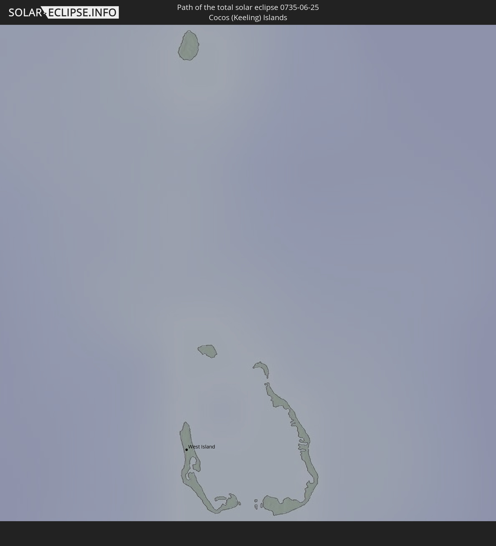 Cocos Islands
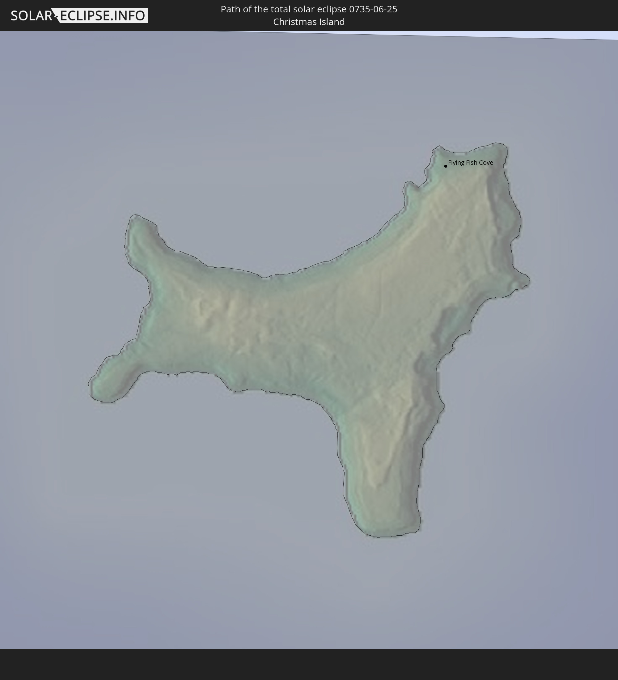 Christmas Island
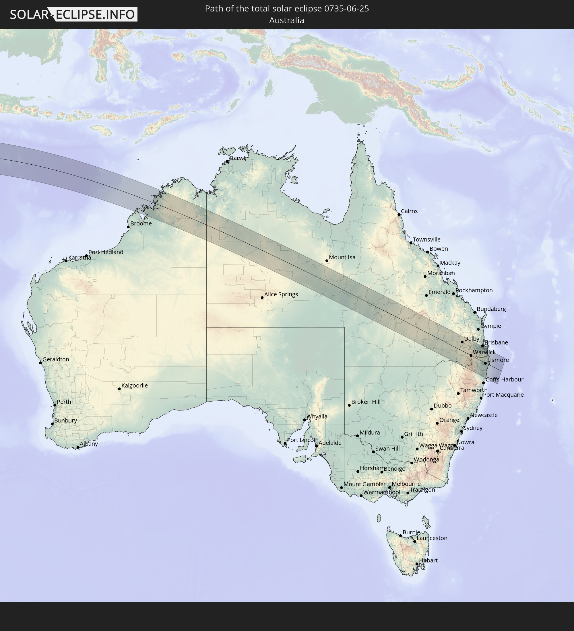 Australia
In den folgenden Ländern ist die Sonnenfinsternis partiell zu sehen
 Antarctica
 Tanzania
 Mozambique
 Kenya
Kenya
 French Southern and Antarctic Lands
 Madagascar
 Comoros
 Mayotte
 Seychelles
 Réunion
 Mauritius
 India
India
 British Indian Ocean Territory
 Heard Island and McDonald Islands
 Maldives
 China
China
 Sri Lanka
 Myanmar
 Indonesia
 Cocos Islands
 Thailand
 Malaysia
 Laos
Laos
 Vietnam
 Cambodia
 Singapore
 Christmas Island
 Australia
 Brunei
 Philippines
 East Timor
 Palau
Palau
 Federated States of Micronesia
 Papua New Guinea
 Solomon Islands
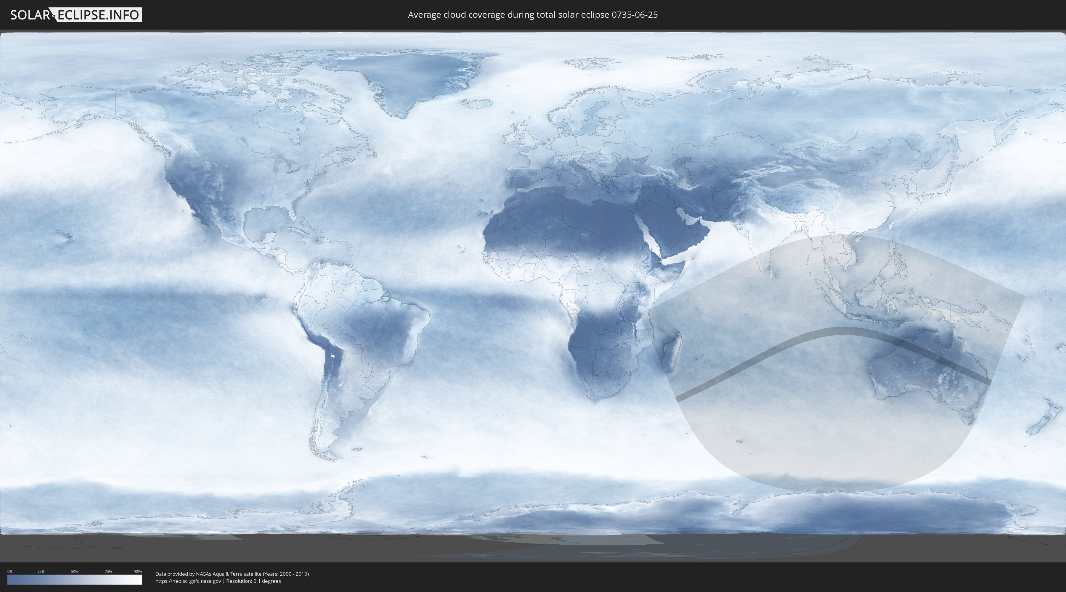
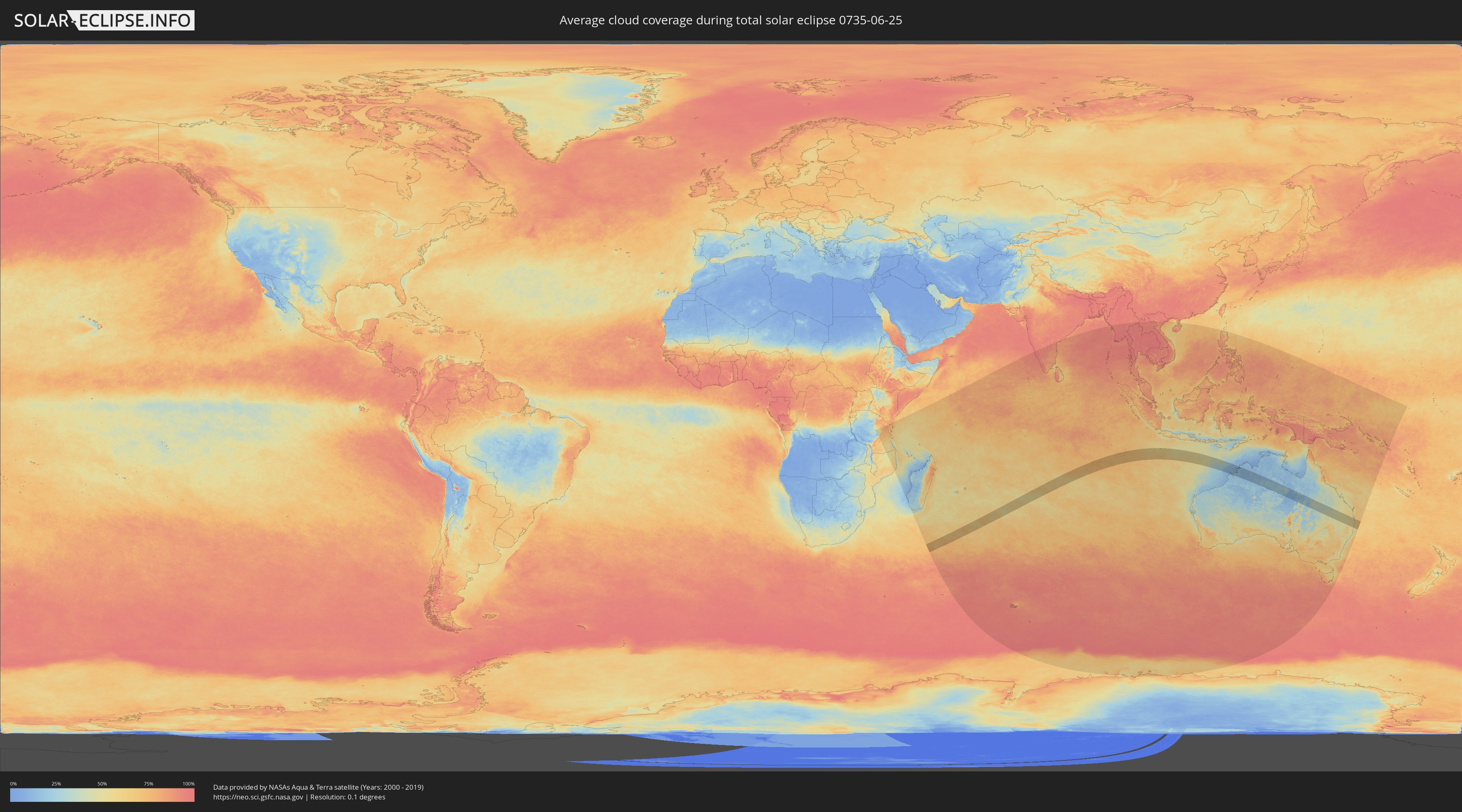
How will be the weather during the total solar eclipse on 06/25/0735?
Where is the best place to see the total solar eclipse of 06/25/0735?
The following maps show the average cloud coverage for the day of the total solar eclipse.
With the help of these maps, it is possible to find the place along the eclipse path, which has the best
chance of a cloudless sky.
Nevertheless, you should consider local circumstances and inform about the weather of your chosen
observation site.
The data is provided by NASAs satellites
AQUA and TERRA.
The cloud maps are averaged over a period of 19 years (2000 - 2019).
Detailed country maps
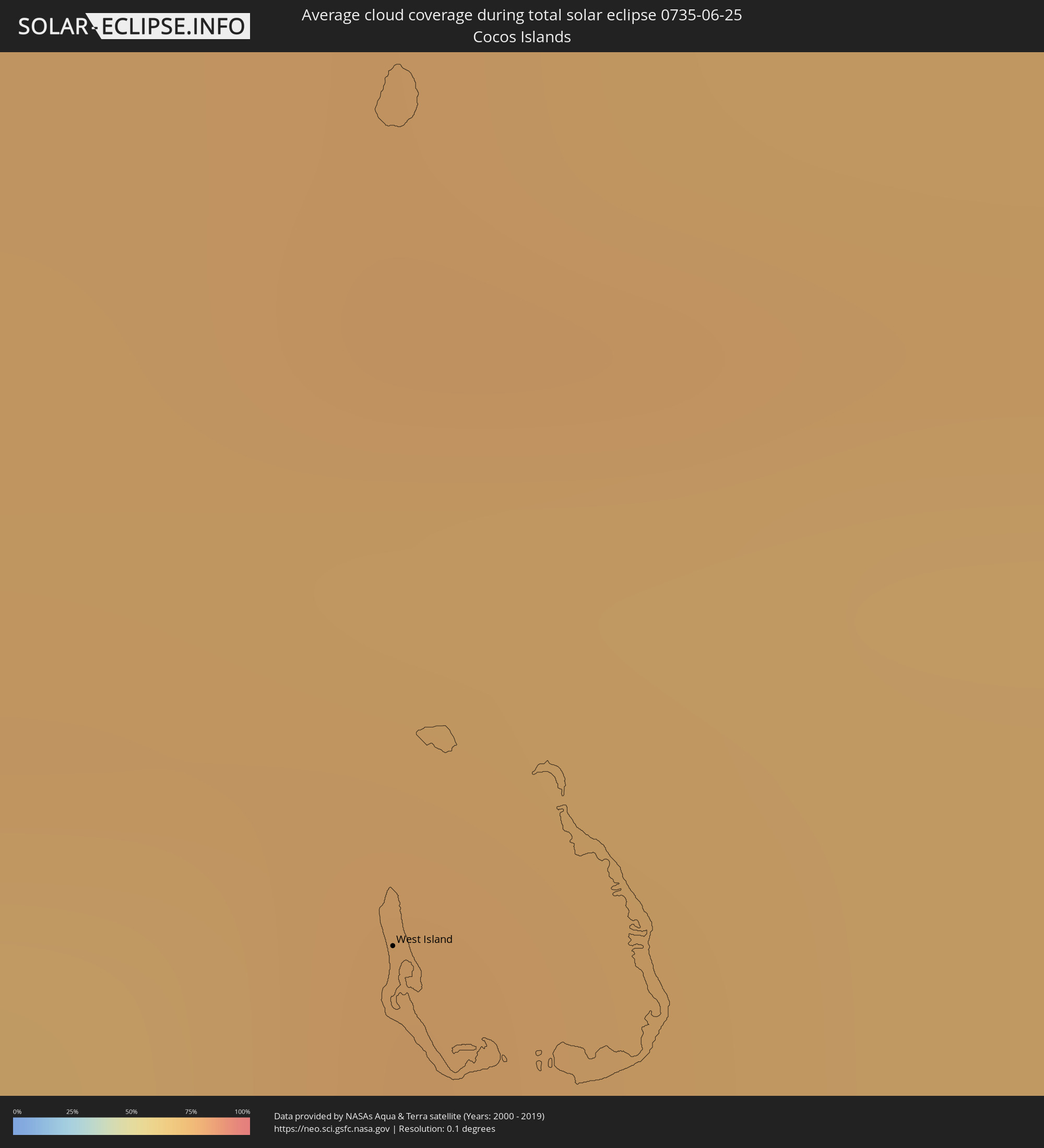 Cocos Islands
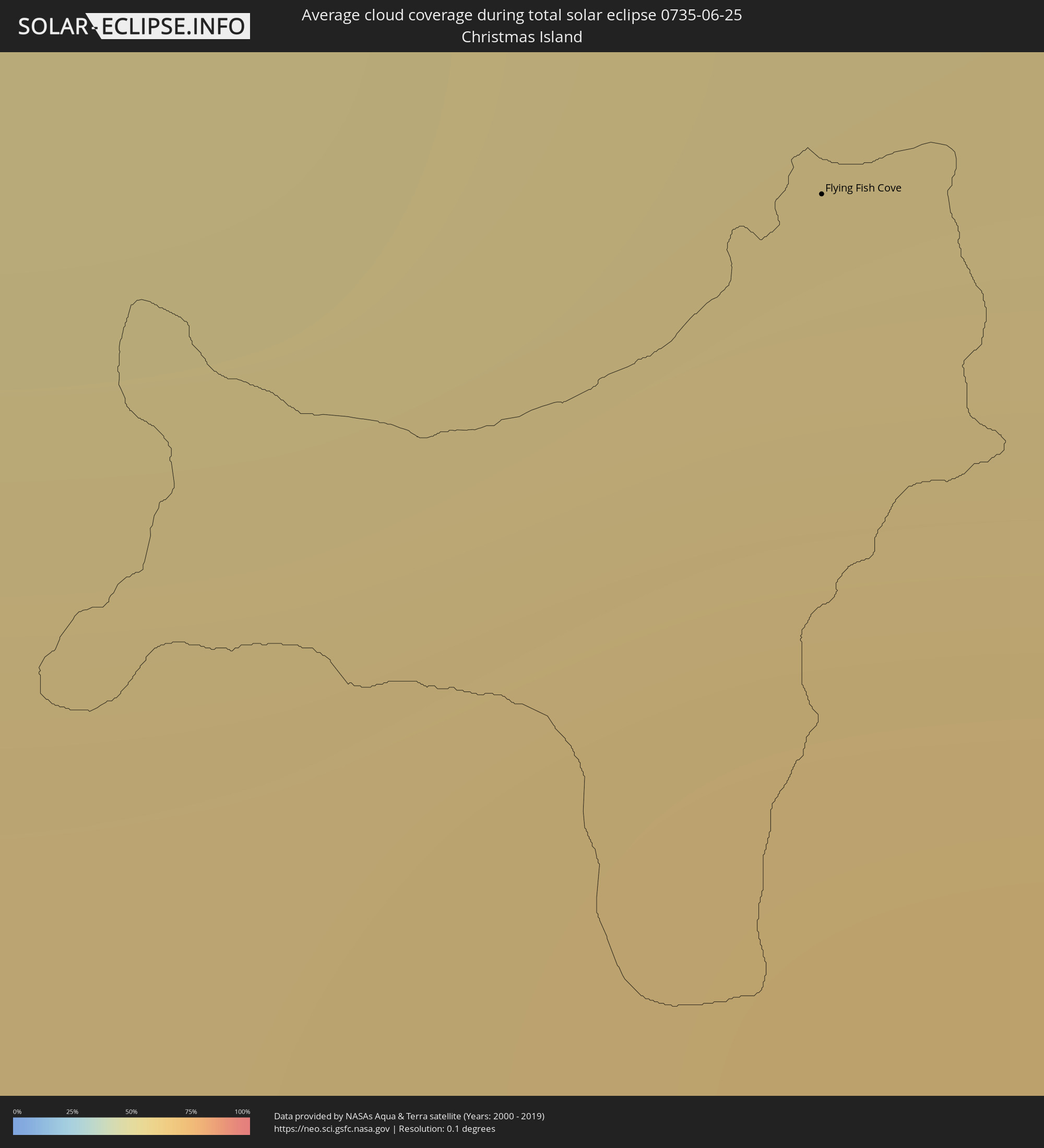 Christmas Island
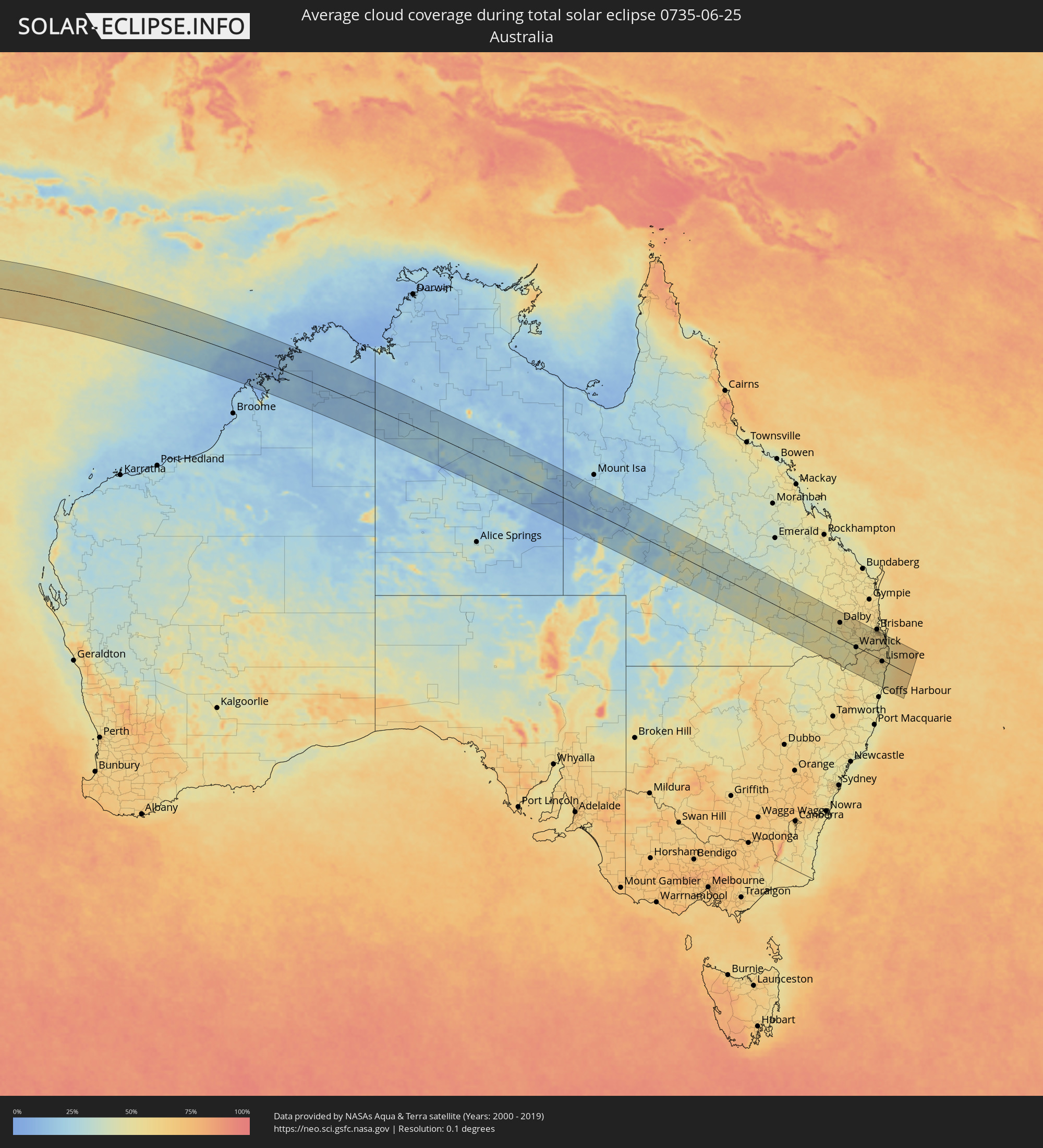 Australia
Cities inside the path of the eclipse
The following table shows all locations with a population of more than 5,000 inside the eclipse path. Cities which have more than 100,000 inhabitants are marked bold. A click at the locations opens a detailed map.
| City | Type | Eclipse duration | Local time of max. eclipse | Distance to central line | Ø Cloud coverage |
|
West Island
|
total | - | 11:36:14 UTC+06:30 | 50 km | 72% |
|
Flying Fish Cove
|
total | - | 12:34:03 UTC+07:00 | 144 km | 62% |
|
Roma, Queensland
|
total | - | 16:44:25 UTC+10:00 | 14 km | 48% |
|
Goondiwindi, Queensland
|
total | - | 16:43:47 UTC+10:00 | 113 km | 51% |
|
Dalby, Queensland
|
total | - | 16:45:15 UTC+10:00 | 65 km | 55% |
|
Darling Heights, Queensland
|
total | - | 16:45:15 UTC+10:00 | 55 km | 54% |
|
Toowoomba, Queensland
|
total | - | 16:45:18 UTC+10:00 | 59 km | 54% |
|
East Toowoomba, Queensland
|
total | - | 16:45:18 UTC+10:00 | 59 km | 54% |
|
Rangeville, Queensland
|
total | - | 16:45:17 UTC+10:00 | 58 km | 54% |
|
Warwick, Queensland
|
total | - | 16:44:51 UTC+10:00 | 2 km | 52% |
|
Gatton, Queensland
|
total | - | 16:45:26 UTC+10:00 | 74 km | 57% |
|
Gordon, New South Wales
|
total | - | 16:44:19 UTC+10:00 | 78 km | 54% |
|
Brassall, Queensland
|
total | - | 16:45:36 UTC+10:00 | 91 km | 59% |
|
Flinders View, Queensland
|
total | - | 16:45:35 UTC+10:00 | 87 km | 57% |
|
Raceview, Queensland
|
total | - | 16:45:35 UTC+10:00 | 89 km | 59% |
|
Booval, Queensland
|
total | - | 16:45:36 UTC+10:00 | 92 km | 59% |
|
Bundamba, Queensland
|
total | - | 16:45:37 UTC+10:00 | 93 km | 59% |
|
Redbank Plains, Queensland
|
total | - | 16:45:37 UTC+10:00 | 92 km | 60% |
|
Collingwood Park, Queensland
|
total | - | 16:45:38 UTC+10:00 | 95 km | 60% |
|
Goodna, Queensland
|
total | - | 16:45:39 UTC+10:00 | 97 km | 60% |
|
Springfield, Queensland
|
total | - | 16:45:38 UTC+10:00 | 93 km | 56% |
|
South Grafton, New South Wales
|
total | - | 16:44:05 UTC+10:00 | 109 km | 55% |
|
Grafton, New South Wales
|
total | - | 16:44:06 UTC+10:00 | 106 km | 55% |
|
Forest Lake, Queensland
|
total | - | 16:45:40 UTC+10:00 | 98 km | 62% |
|
Inala, Queensland
|
total | - | 16:45:42 UTC+10:00 | 102 km | 62% |
|
Tarragindi, Queensland
|
total | - | 16:45:46 UTC+10:00 | 110 km | 60% |
|
Casino, New South Wales
|
total | - | 16:44:48 UTC+10:00 | 20 km | 58% |
|
Sunnybank, Queensland
|
total | - | 16:45:44 UTC+10:00 | 106 km | 61% |
|
Sunnybank Hills, Queensland
|
total | - | 16:45:43 UTC+10:00 | 104 km | 61% |
|
Upper Mount Gravatt, Queensland
|
total | - | 16:45:46 UTC+10:00 | 110 km | 61% |
|
Woodridge, Queensland
|
total | - | 16:45:43 UTC+10:00 | 104 km | 61% |
|
Logan City, Queensland
|
total | - | 16:45:43 UTC+10:00 | 103 km | 61% |
|
Rochedale South, Queensland
|
total | - | 16:45:45 UTC+10:00 | 108 km | 61% |
|
Springwood, Queensland
|
total | - | 16:45:45 UTC+10:00 | 107 km | 61% |
|
Waterford West, Queensland
|
total | - | 16:45:41 UTC+10:00 | 99 km | 59% |
|
Slacks Creek, Queensland
|
total | - | 16:45:44 UTC+10:00 | 104 km | 60% |
|
Tamborine Mountain, Queensland
|
total | - | 16:45:31 UTC+10:00 | 75 km | 54% |
|
Beenleigh, Queensland
|
total | - | 16:45:42 UTC+10:00 | 100 km | 60% |
|
Lismore, New South Wales
|
total | - | 16:44:55 UTC+10:00 | 5 km | 60% |
|
East Lismore, New South Wales
|
total | - | 16:44:55 UTC+10:00 | 6 km | 60% |
|
Upper Coomera, Queensland
|
total | - | 16:45:36 UTC+10:00 | 86 km | 56% |
|
Oxenford, Queensland
|
total | - | 16:45:37 UTC+10:00 | 88 km | 56% |
|
Goonellabah, New South Wales
|
total | - | 16:44:56 UTC+10:00 | 4 km | 60% |
|
Nerang, Queensland
|
total | - | 16:45:33 UTC+10:00 | 79 km | 54% |
|
Murwillumbah, New South Wales
|
total | - | 16:45:20 UTC+10:00 | 48 km | 57% |
|
Southport, Queensland
|
total | - | 16:45:36 UTC+10:00 | 84 km | 58% |
|
Varsity Lakes, Queensland
|
total | - | 16:45:31 UTC+10:00 | 72 km | 55% |
|
Burleigh Waters, Queensland
|
total | - | 16:45:31 UTC+10:00 | 72 km | 55% |
|
Surfers Paradise, Queensland
|
total | - | 16:45:35 UTC+10:00 | 82 km | 58% |
|
Gold Coast, Queensland
|
total | - | 16:45:35 UTC+10:00 | 82 km | 58% |
|
Palm Beach, Queensland
|
total | - | 16:45:31 UTC+10:00 | 72 km | 55% |
|
Tweed Heads West, New South Wales
|
total | - | 16:45:29 UTC+10:00 | 68 km | 56% |
|
Banora Point, New South Wales
|
total | - | 16:45:28 UTC+10:00 | 66 km | 56% |
|
Ballina, New South Wales
|
total | - | 16:45:00 UTC+10:00 | 3 km | 54% |
|
Kingscliff, New South Wales
|
total | - | 16:45:27 UTC+10:00 | 63 km | 53% |
|
East Ballina, New South Wales
|
total | - | 16:45:00 UTC+10:00 | 3 km | 54% |
|
Byron Bay, New South Wales
|
total | - | 16:45:11 UTC+10:00 | 27 km | 56% |