Totale Sonnenfinsternis vom 14.05.0812
| Wochentag: | Montag |
| Maximale Dauer der Verfinsterung: | 04m00s |
| Maximale Breite des Finsternispfades: | 157 km |
| Saroszyklus: | 99 |
| Bedeckungsgrad: | 100% |
| Magnitude: | 1.0464 |
| Gamma: | 0.1939 |
Wo kann man die Sonnenfinsternis vom 14.05.0812 sehen?
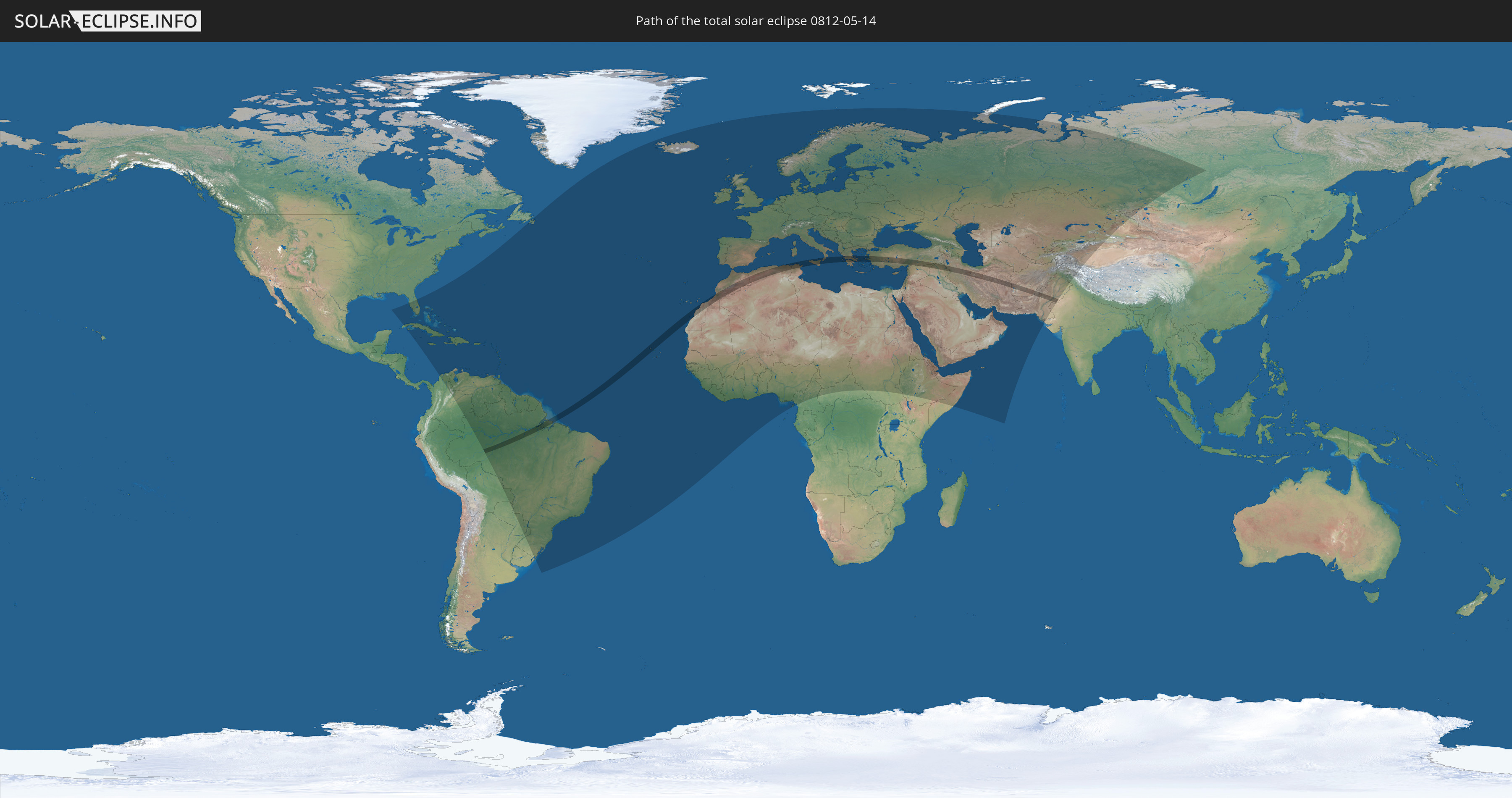
Die Sonnenfinsternis am 14.05.0812 kann man in 148 Ländern als partielle Sonnenfinsternis beobachten.
Der Finsternispfad verläuft durch 13 Länder. Nur in diesen Ländern ist sie als totale Sonnenfinsternis zu sehen.
In den folgenden Ländern ist die Sonnenfinsternis total zu sehen
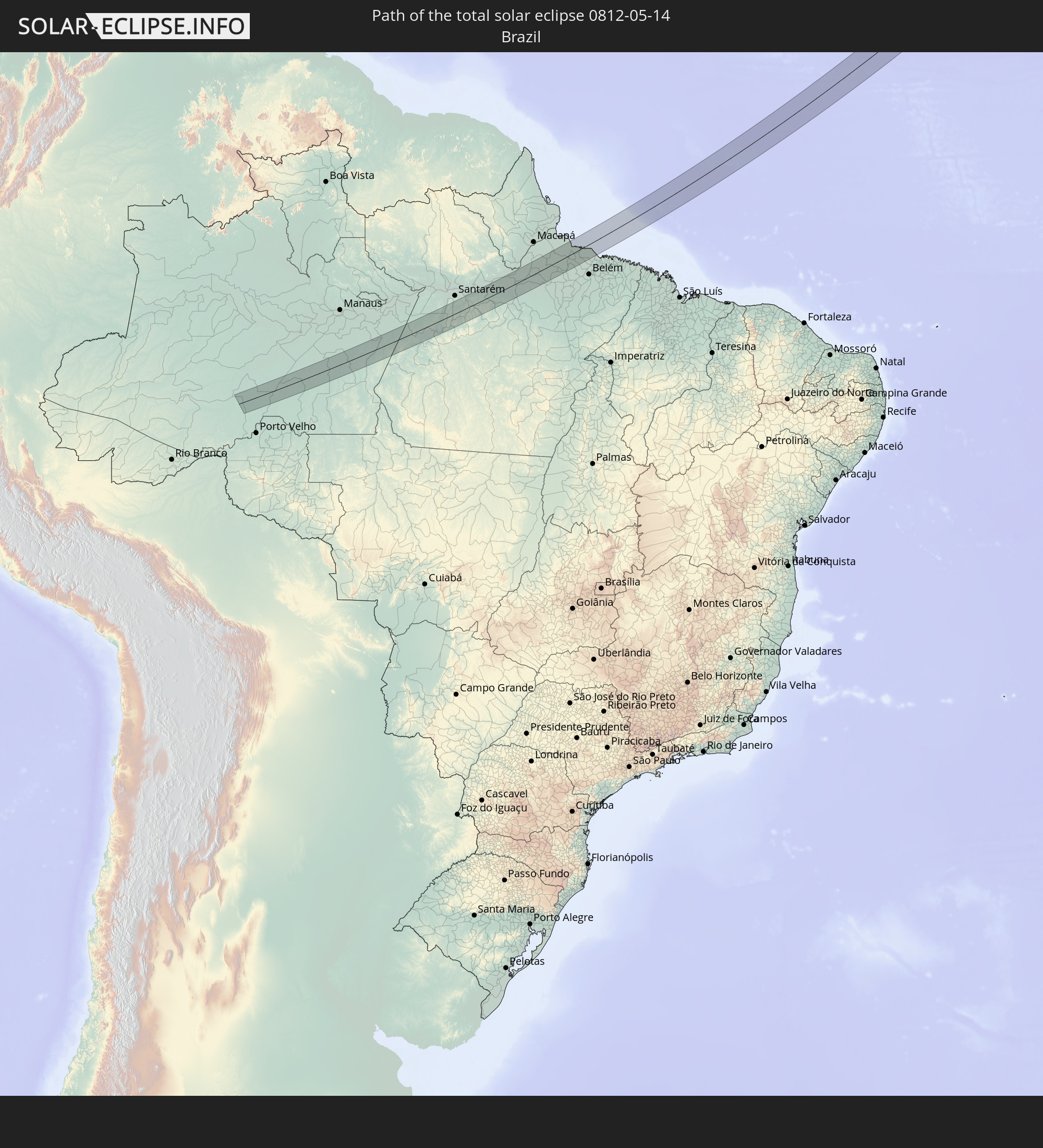 Brasilien
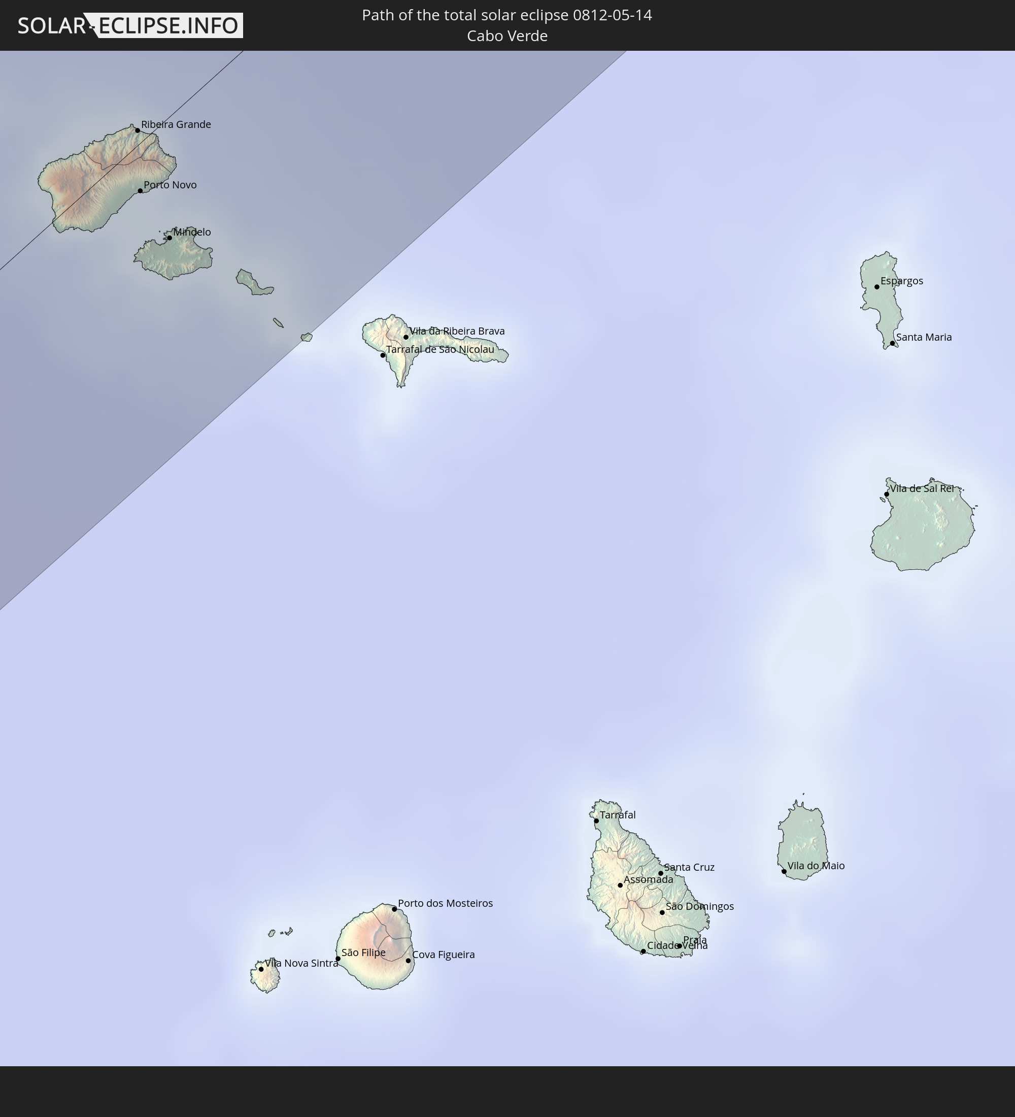 Kap Verde
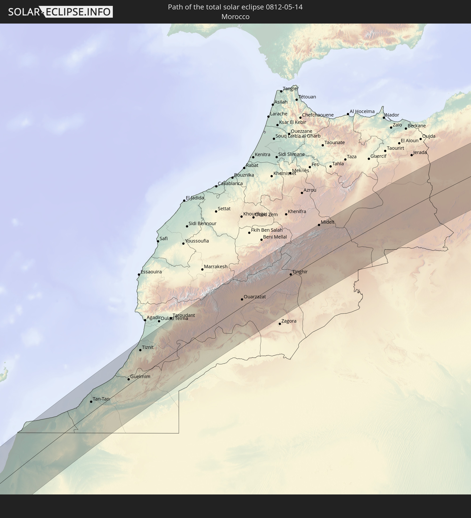 Marokko
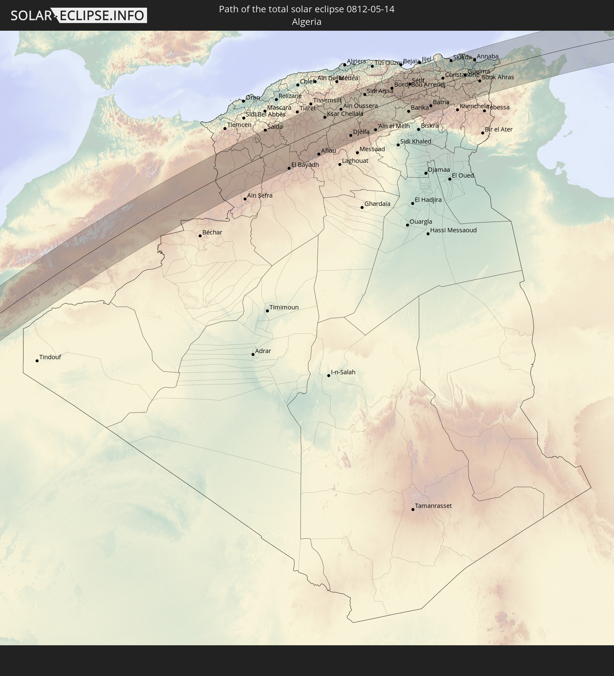 Algerien
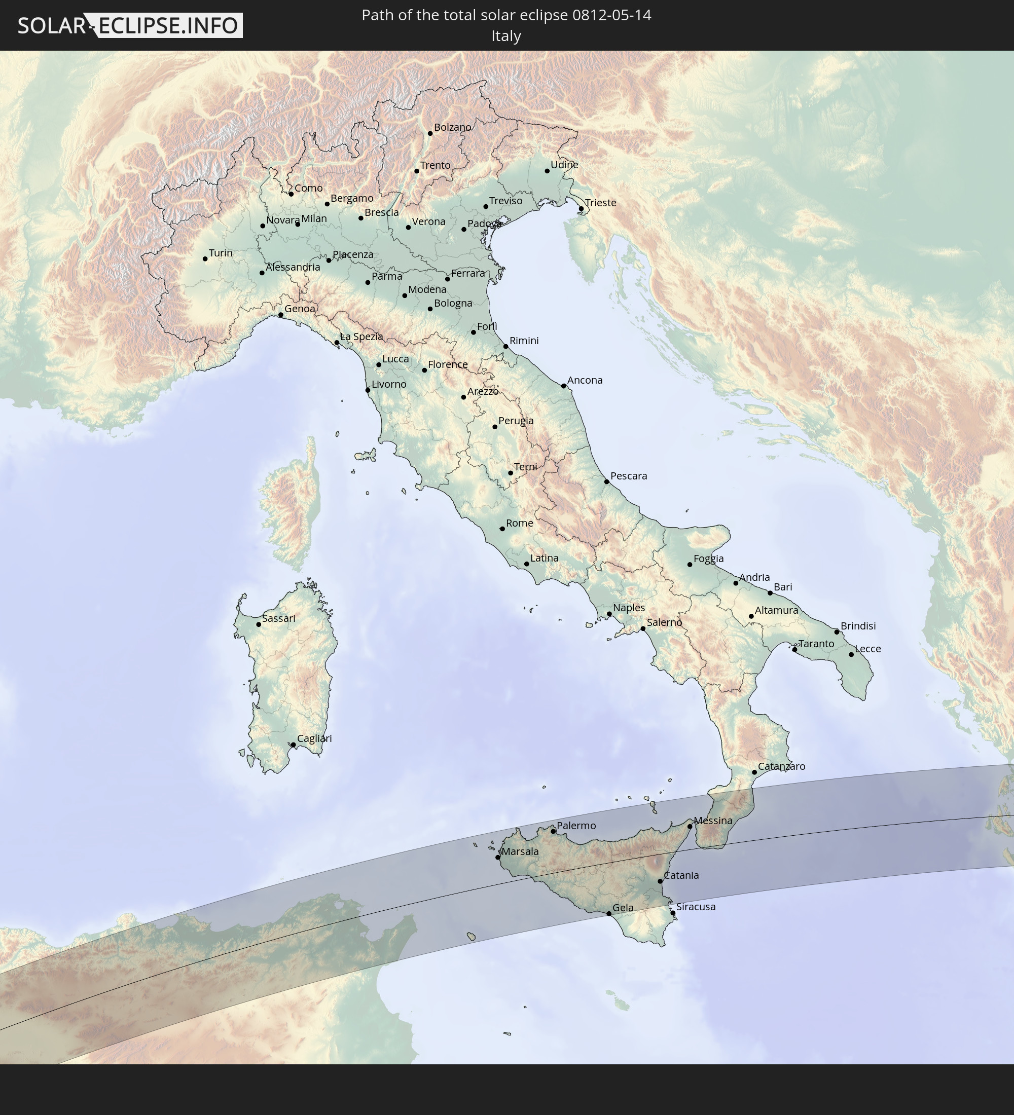 Italien
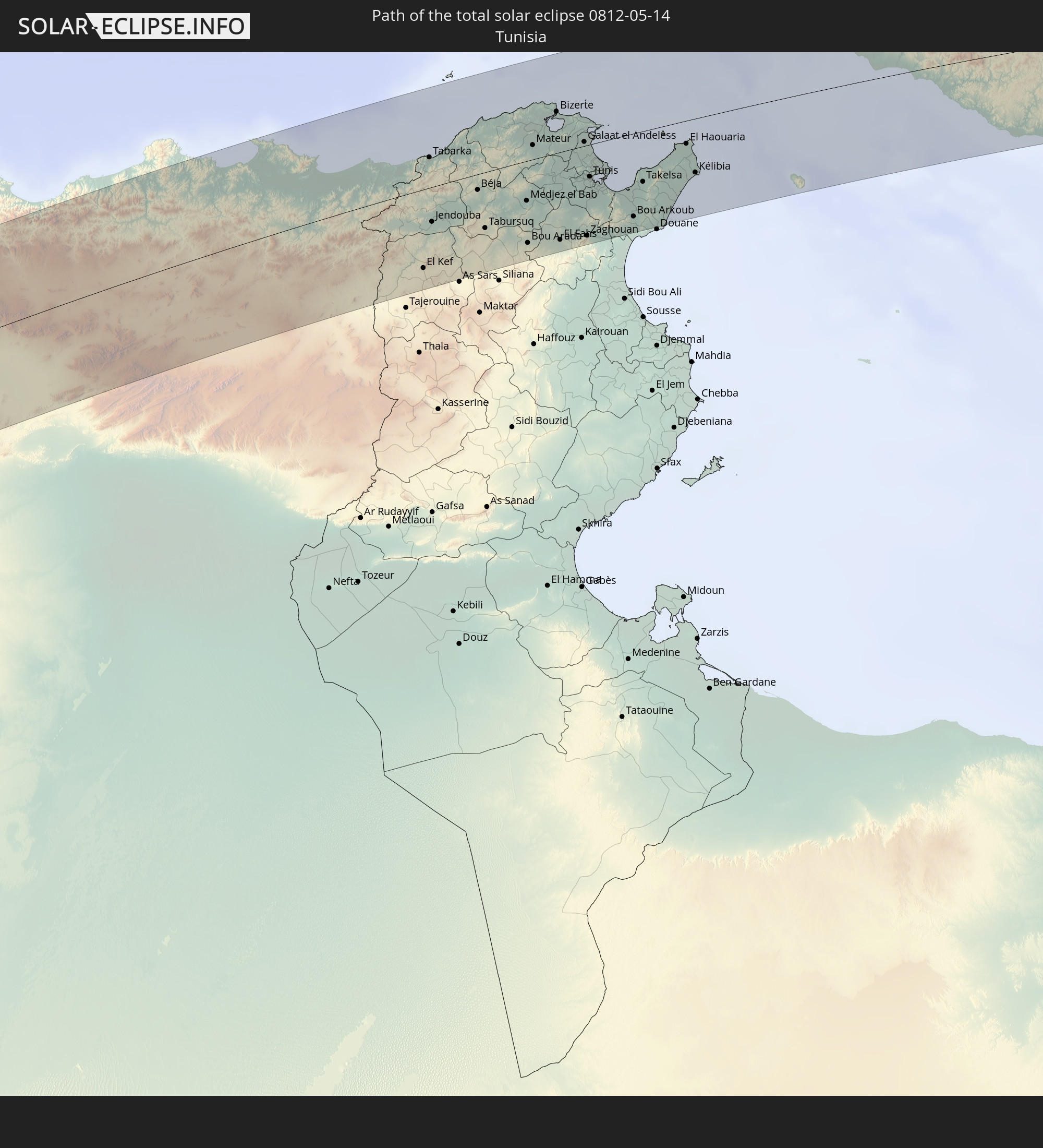 Tunesien
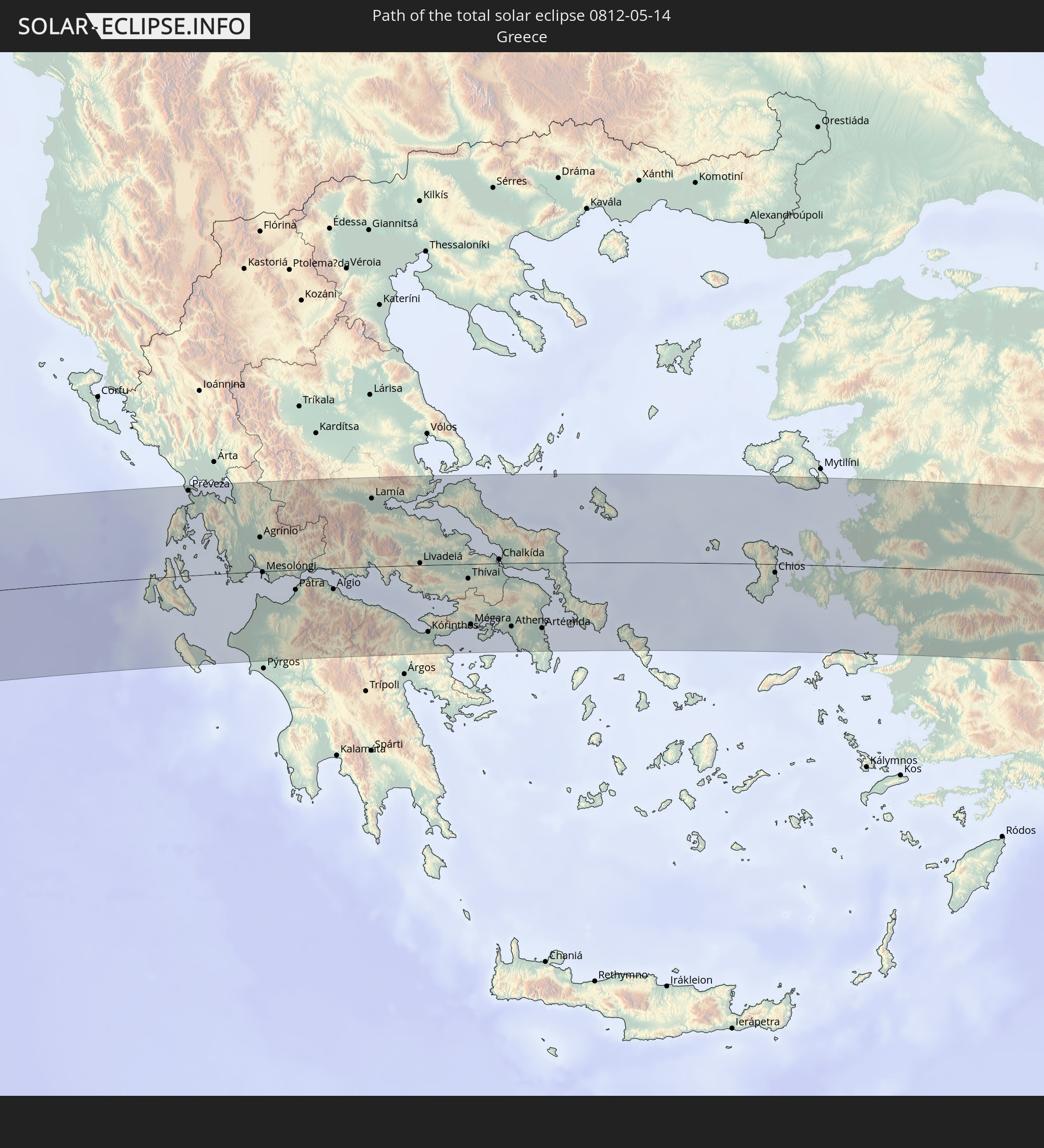 Griechenland
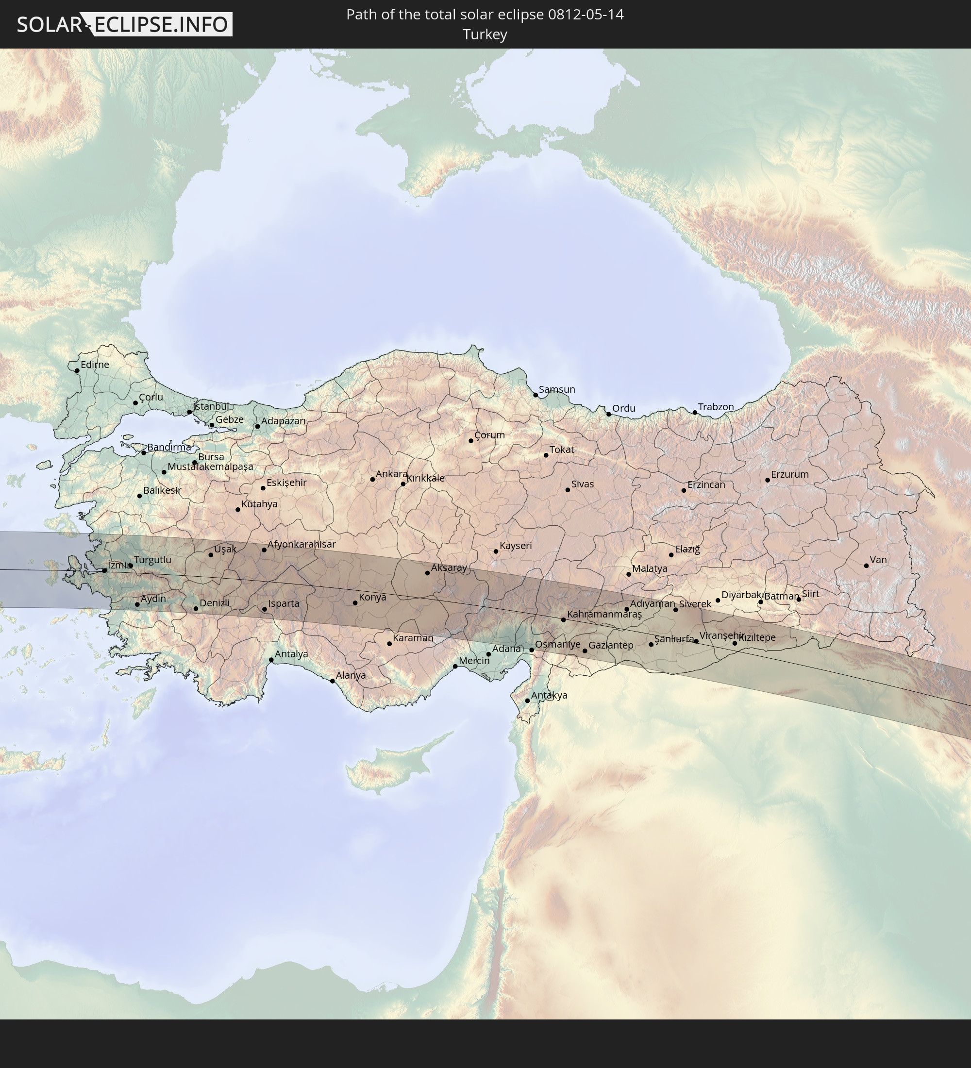 Türkei
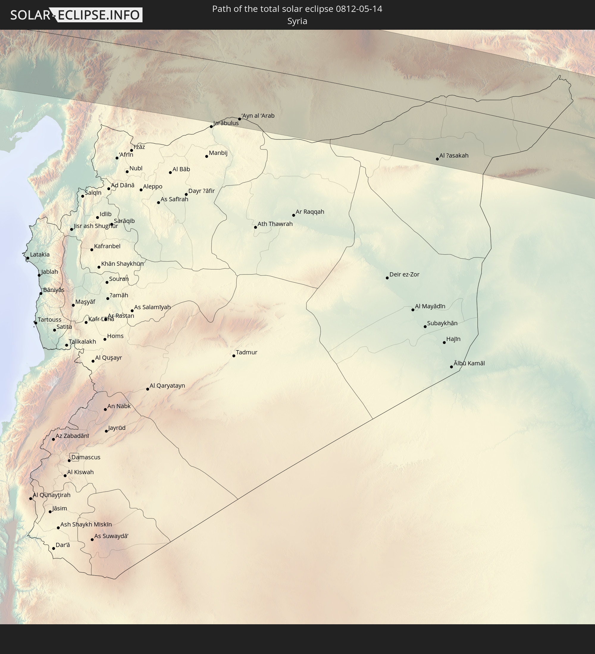 Syrien
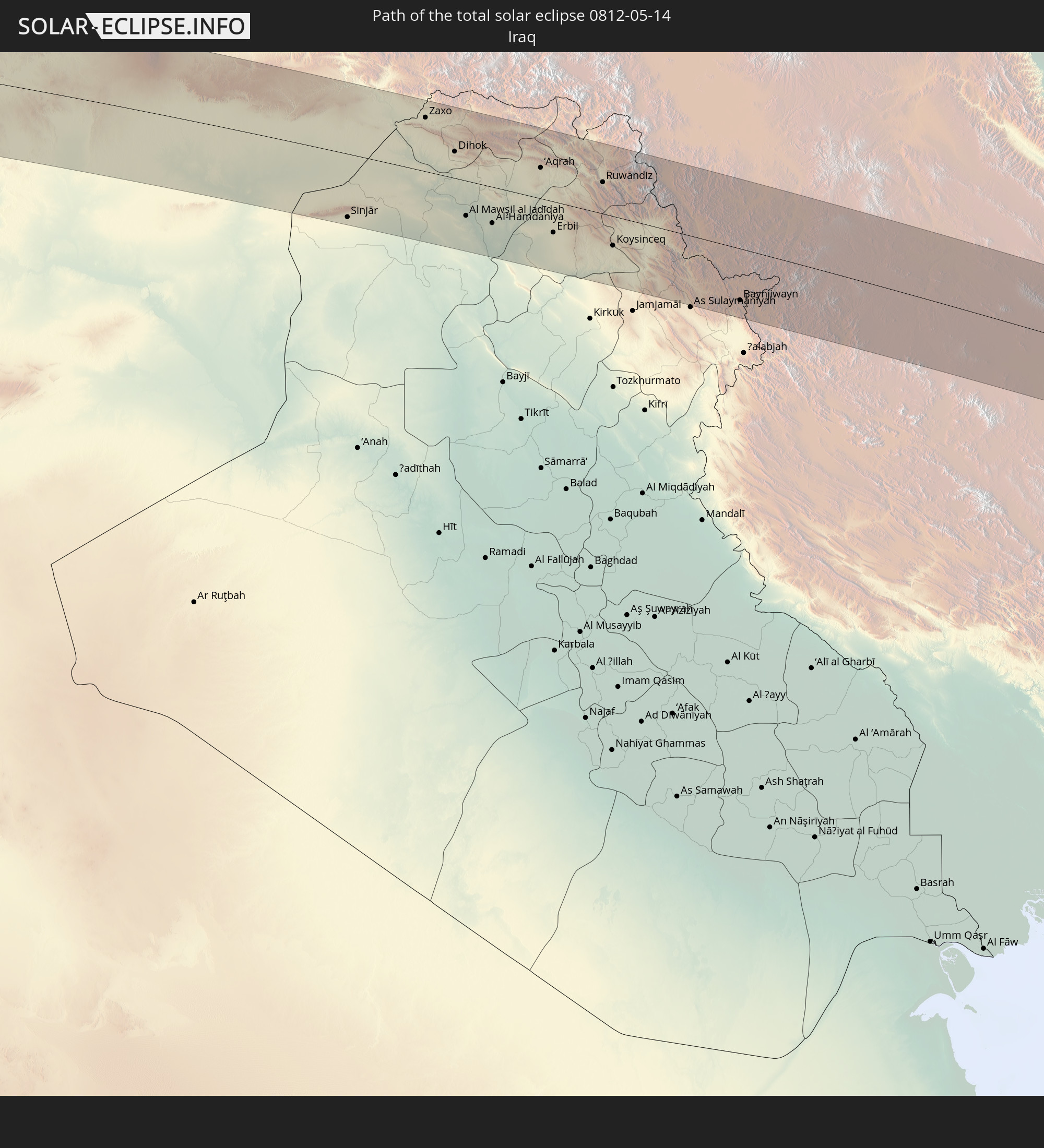 Irak
Irak
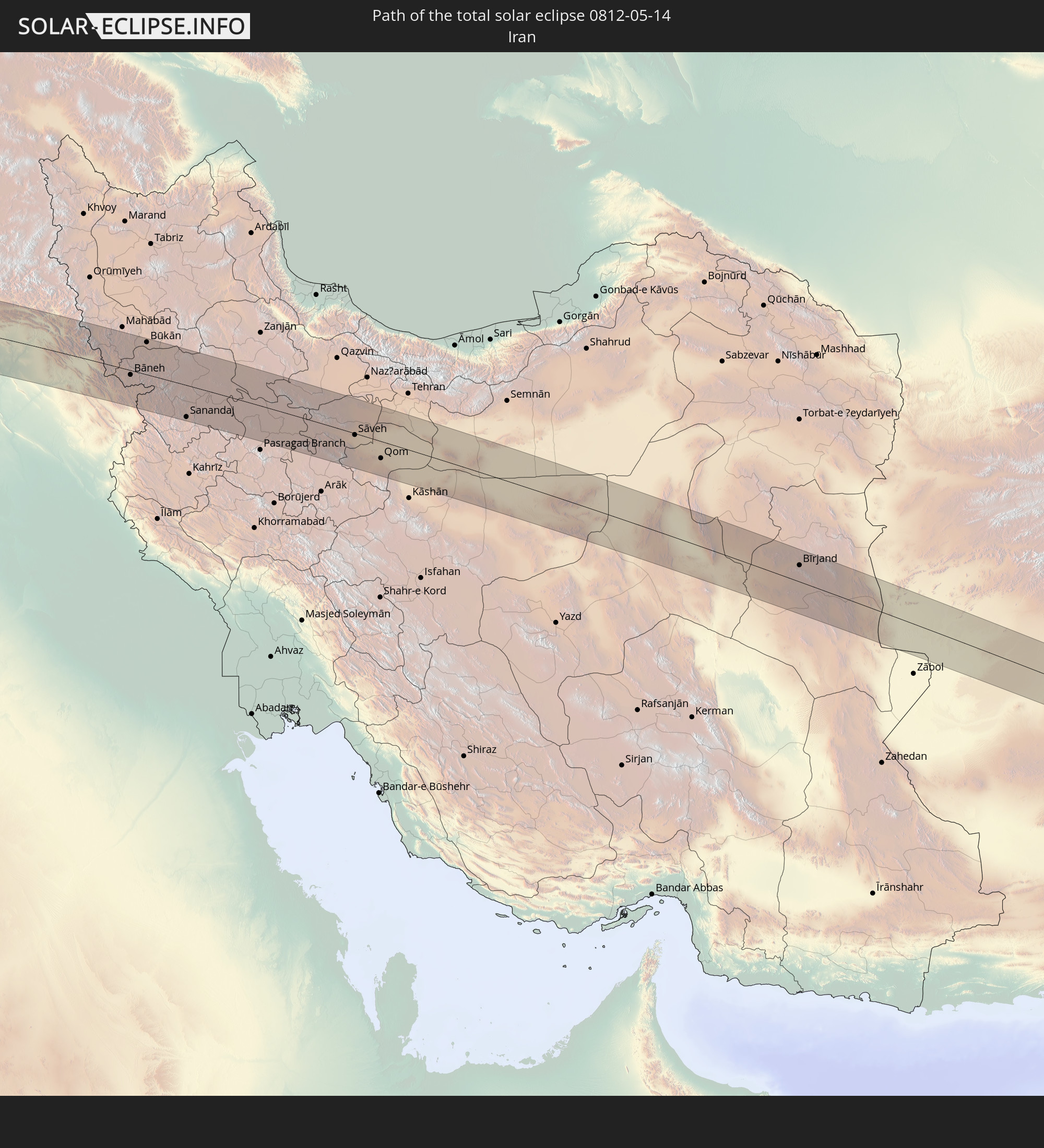 Iran
Iran
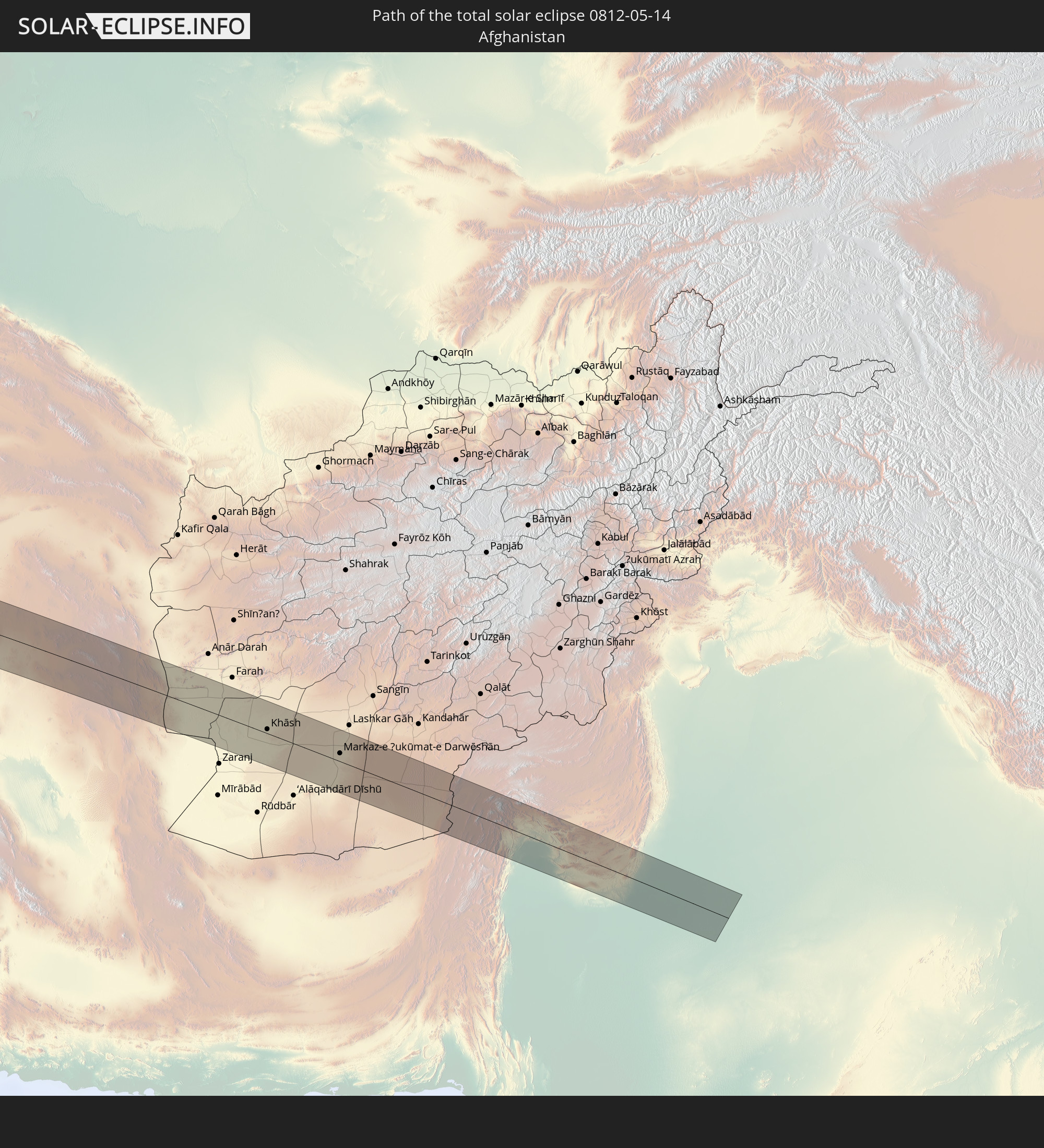 Afghanistan
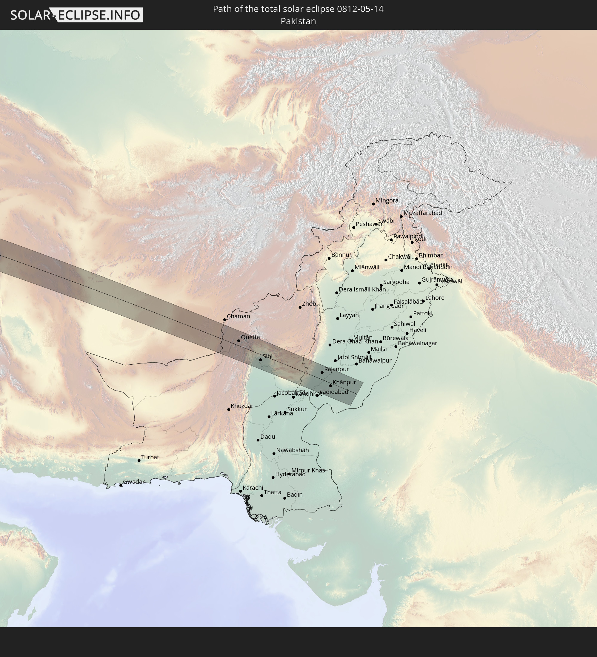 Pakistan
In den folgenden Ländern ist die Sonnenfinsternis partiell zu sehen
 Russland
 Vereinigte Staaten
 United States Minor Outlying Islands
 Kanada
 Kuba
Kuba
 Kolumbien
 Kaimaninseln
 Bahamas
 Jamaika
 Haiti
Haiti
 Brasilien
 Argentinien
 Venezuela
 Turks- und Caicosinseln
 Dominikanische Republik
 Aruba
Aruba
 Bolivien
 Puerto Rico
 Amerikanische Jungferninseln
 Bermuda
 Britische Jungferninseln
 Anguilla
 Saint-Martin
 Saint-Barthélemy
 St. Kitts und Nevis
 Paraguay
 Antigua und Barbuda
 Montserrat
 Trinidad und Tobago
 Guadeloupe
 Grenada
 Dominica
 St. Vincent und die Grenadinen
 Guyana
 Martinique
 St. Lucia
 Barbados
 Suriname
 Französisch-Guayana
 Portugal
 Kap Verde
 Island
 Spanien
 Senegal
 Mauretanien
 Gambia
 Guinea-Bissau
 Guinea
 St. Helena
 Sierra Leone
 Marokko
 Mali
Mali
 Liberia
 Irland
 Algerien
 Vereinigtes Königreich
 Elfenbeinküste
 Färöer
 Burkina Faso
 Gibraltar
 Frankreich
 Isle of Man
 Ghana
Ghana
 Guernsey
 Jersey
 Togo
Togo
 Niger
Niger
 Benin
Benin
 Andorra
 Belgien
 Nigeria
 Niederlande
 Norwegen
 Äquatorialguinea
 Luxemburg
 Deutschland
 Schweiz
 Italien
 Monaco
 Tunesien
 Dänemark
 Kamerun
 Libyen
 Liechtenstein
 Österreich
 Schweden
 Tschechien
 San Marino
 Vatikanstadt
 Slowenien
 Tschad
 Kroatien
 Polen
Polen
 Malta
Malta
 Zentralafrikanische Republik
 Bosnien und Herzegowina
 Ungarn
 Slowakei
 Montenegro
 Serbien
 Albanien
 Åland Islands
 Griechenland
 Rumänien
 Mazedonien
 Finnland
 Litauen
 Lettland
 Estland
 Sudan
Sudan
 Ukraine
 Bulgarien
 Weißrussland
 Ägypten
 Türkei
 Moldawien
 Republik Zypern
 Äthiopien
 Staat Palästina
 Israel
 Saudi-Arabien
 Jordanien
 Libanon
 Syrien
 Eritrea
 Irak
Irak
 Georgien
 Somalia
 Dschibuti
 Jemen
Jemen
 Armenien
 Iran
Iran
 Aserbaidschan
 Kasachstan
 Kuwait
 Bahrain
 Katar
Katar
 Vereinigte Arabische Emirate
 Oman
Oman
 Turkmenistan
 Usbekistan
 Afghanistan
 Pakistan
 Tadschikistan
 Indien
 Kirgisistan
 Volksrepublik China
 Mongolei
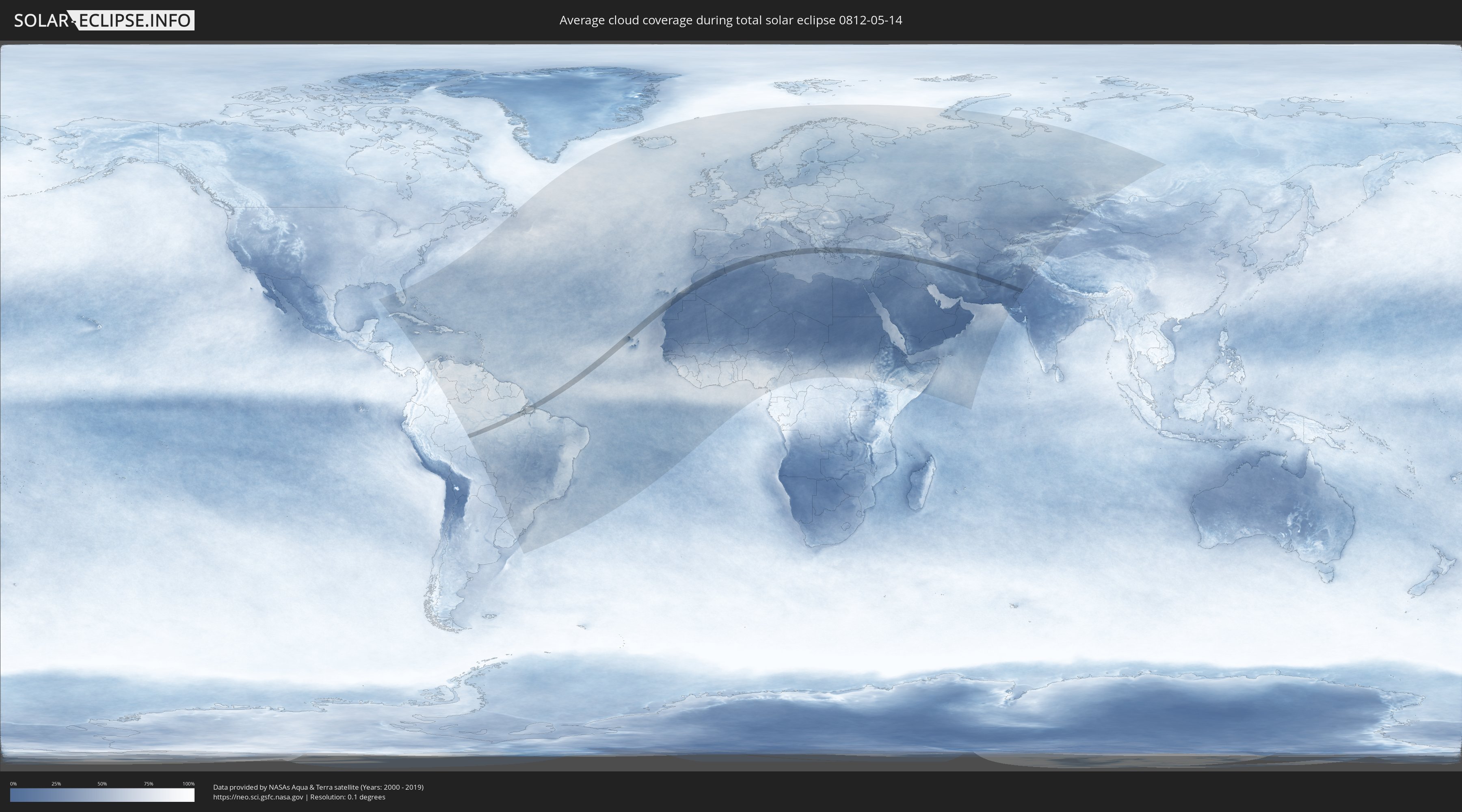
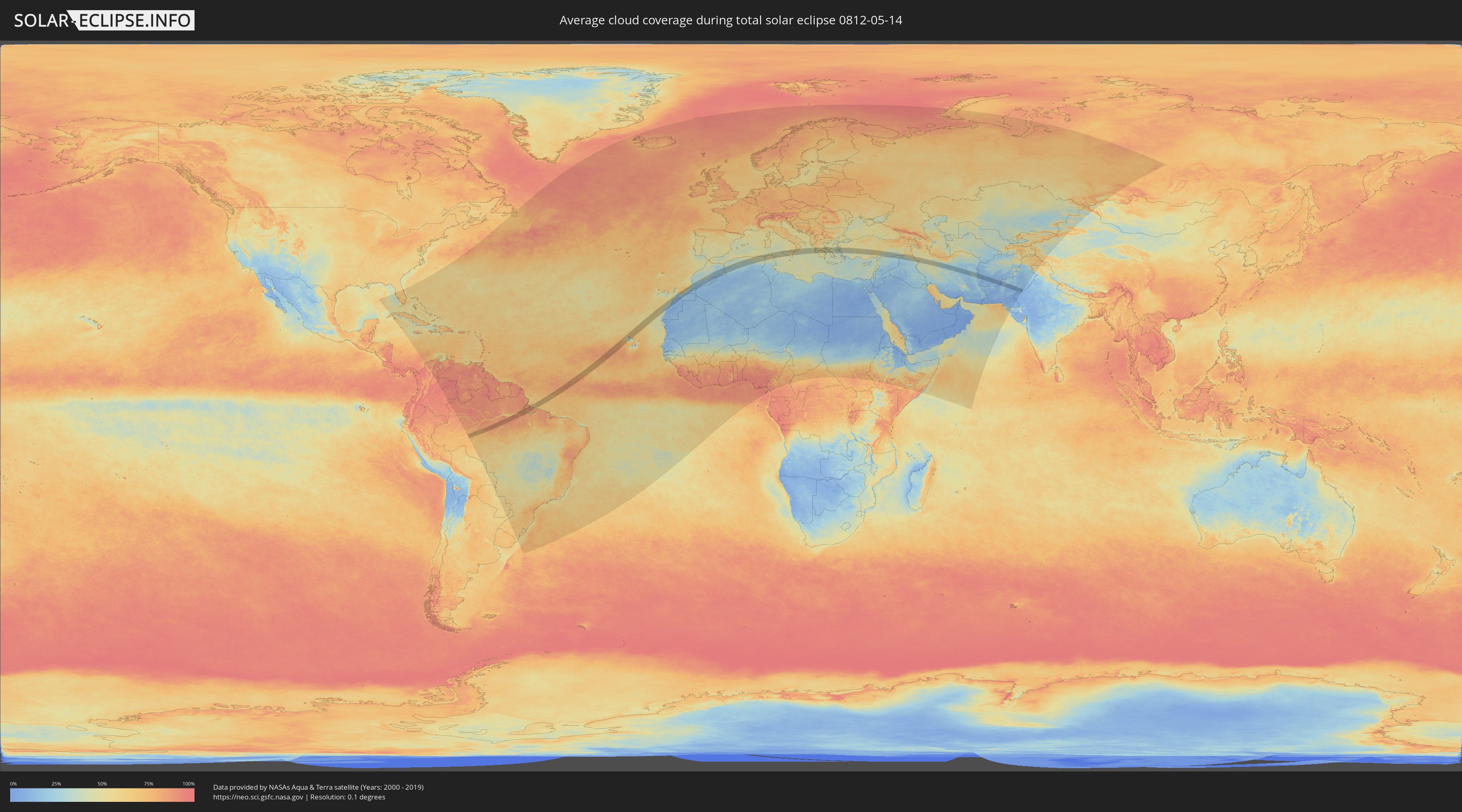
Wie wird das Wetter während der totalen Sonnenfinsternis am 14.05.0812?
Wo ist der beste Ort, um die totale Sonnenfinsternis vom 14.05.0812 zu beobachten?
Die folgenden Karten zeigen die durchschnittliche Bewölkung für den Tag, an dem die totale Sonnenfinsternis
stattfindet. Mit Hilfe der Karten lässt sich der Ort entlang des Finsternispfades eingrenzen,
der die besten Aussichen auf einen klaren wolkenfreien Himmel bietet.
Trotzdem muss man immer lokale Gegenenheiten beachten und sollte sich genau über das Wetter an seinem
gewählten Beobachtungsort informieren.
Die Daten stammen von den beiden NASA-Satelliten
AQUA und TERRA
und wurden über einen Zeitraum von 19 Jahren (2000 - 2019) gemittelt.
Detaillierte Länderkarten
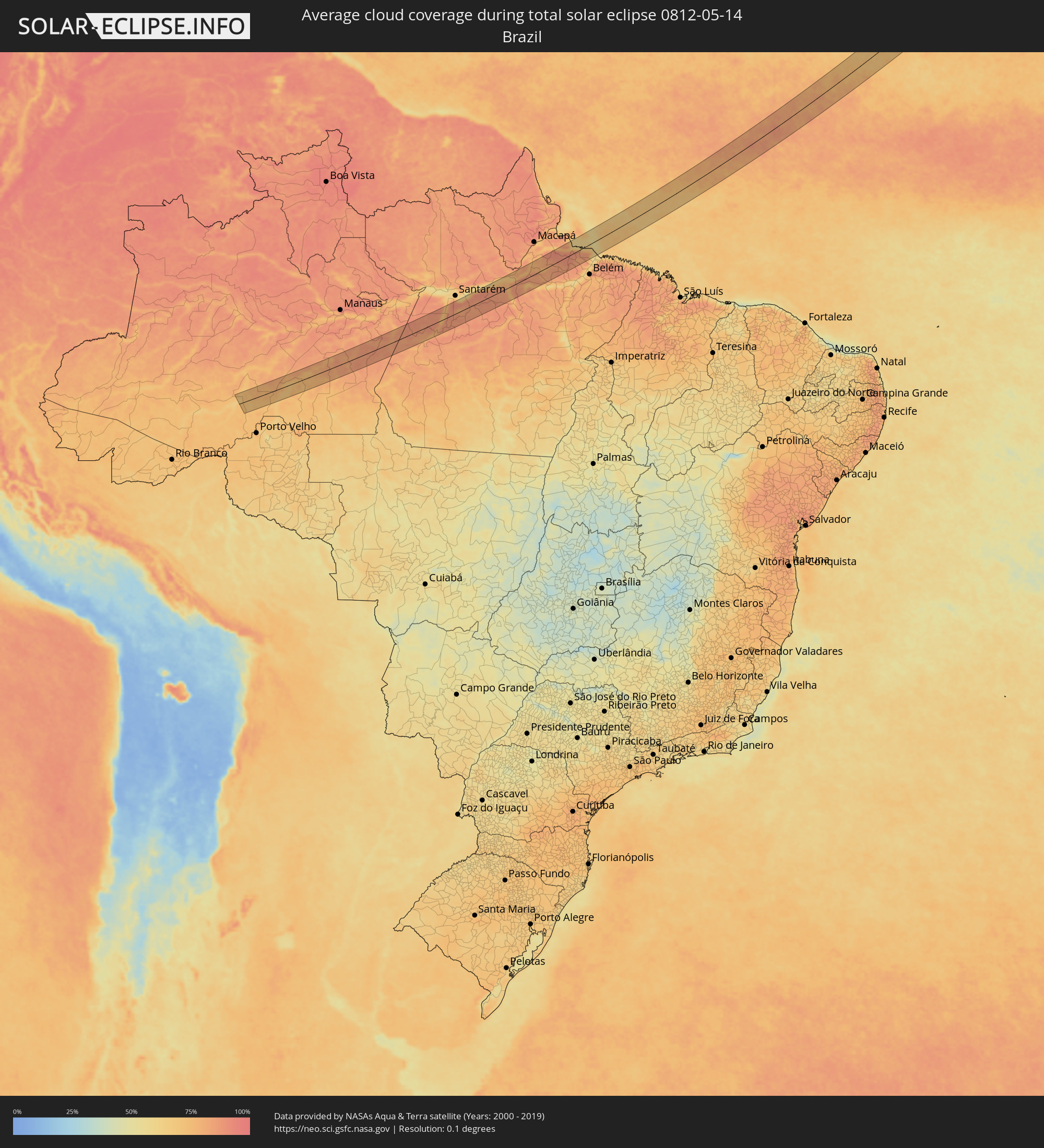 Brasilien
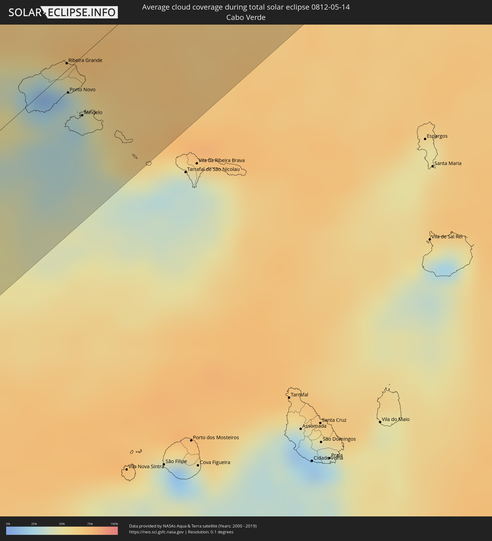 Kap Verde
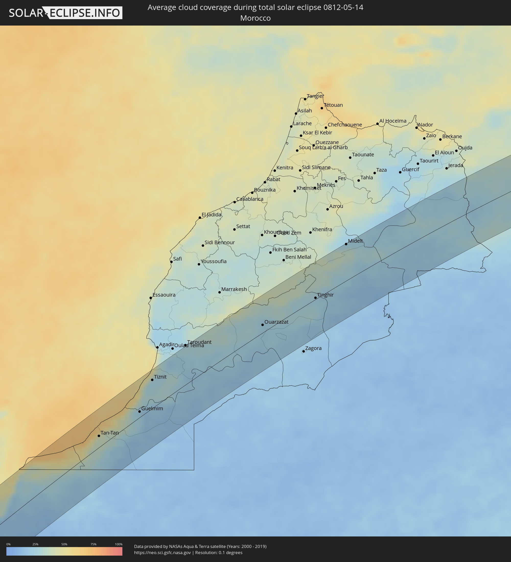 Marokko
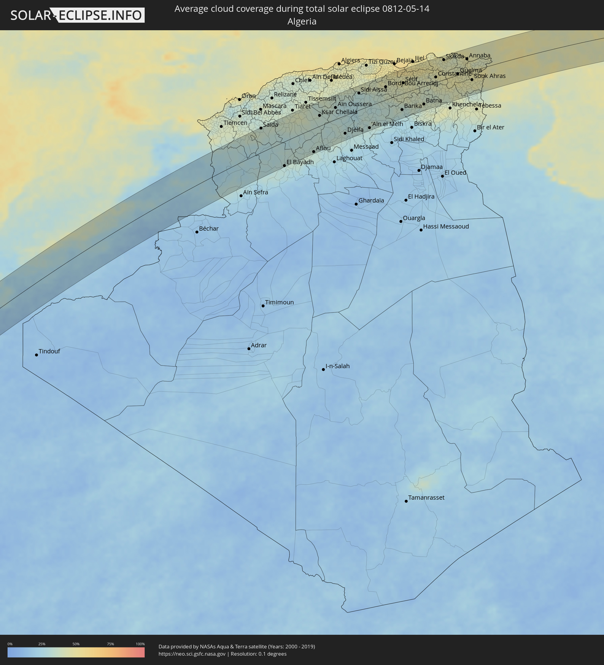 Algerien
 Italien
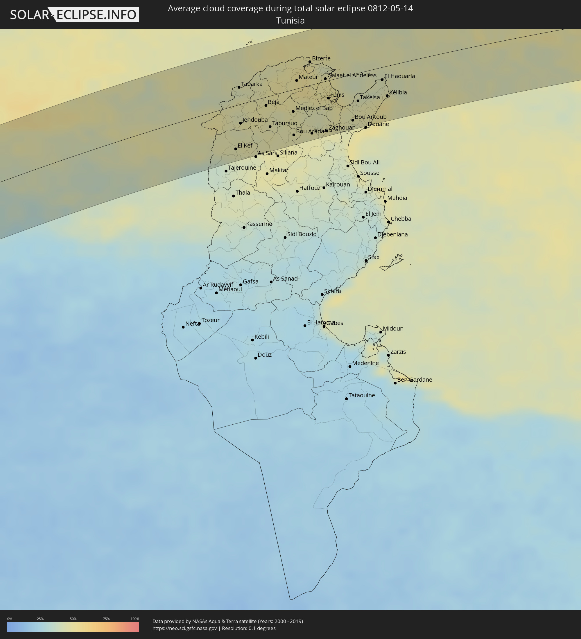 Tunesien
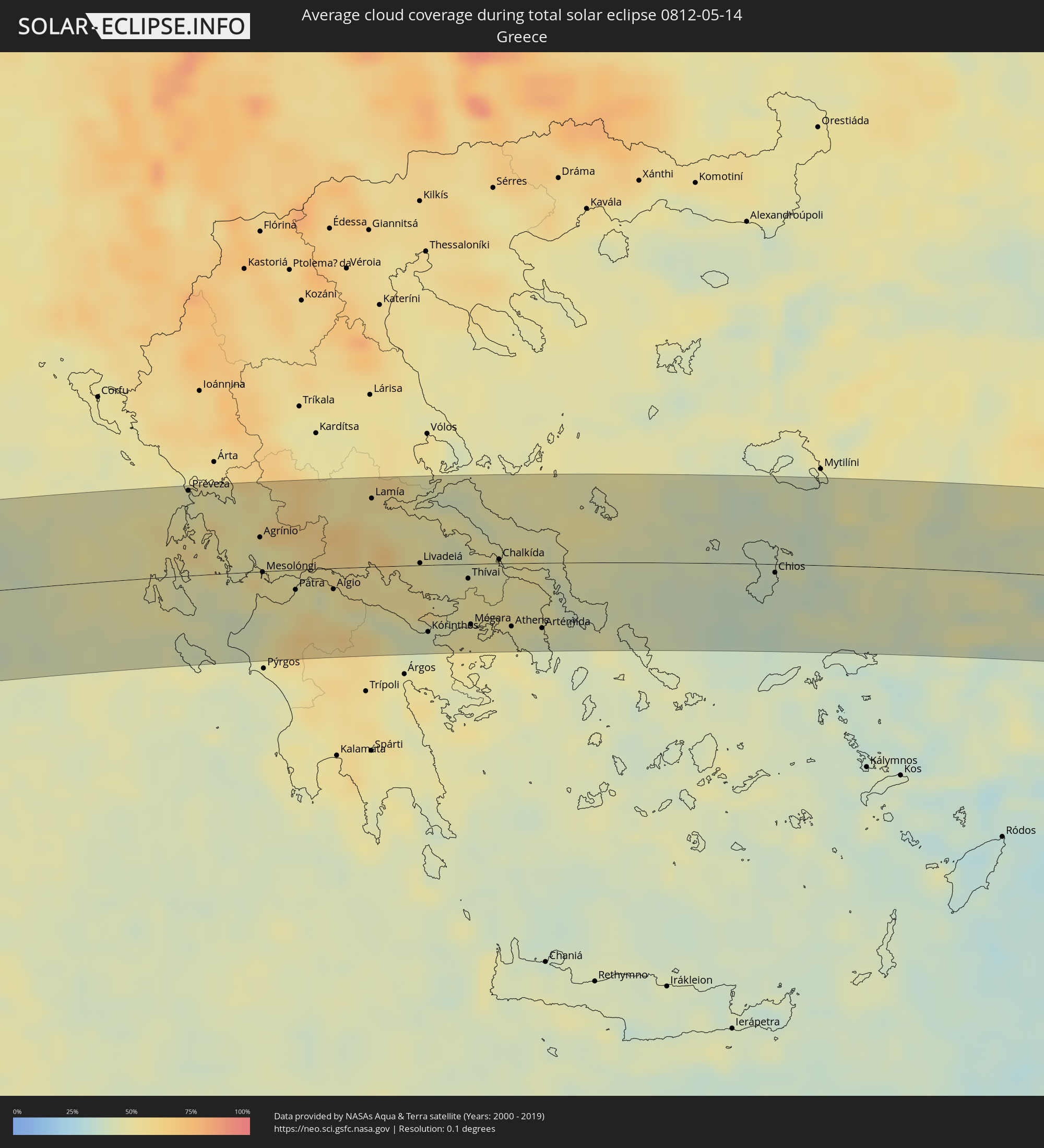 Griechenland
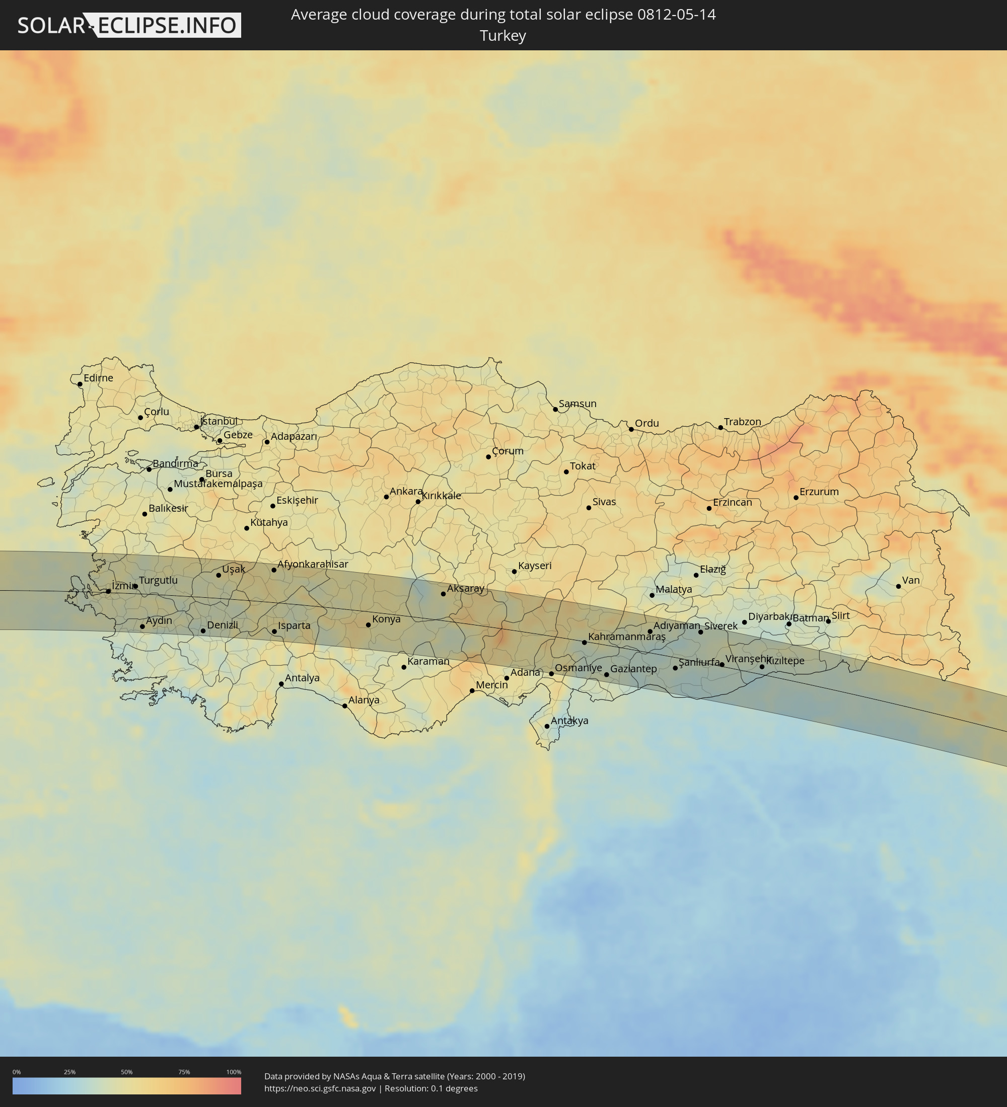 Türkei
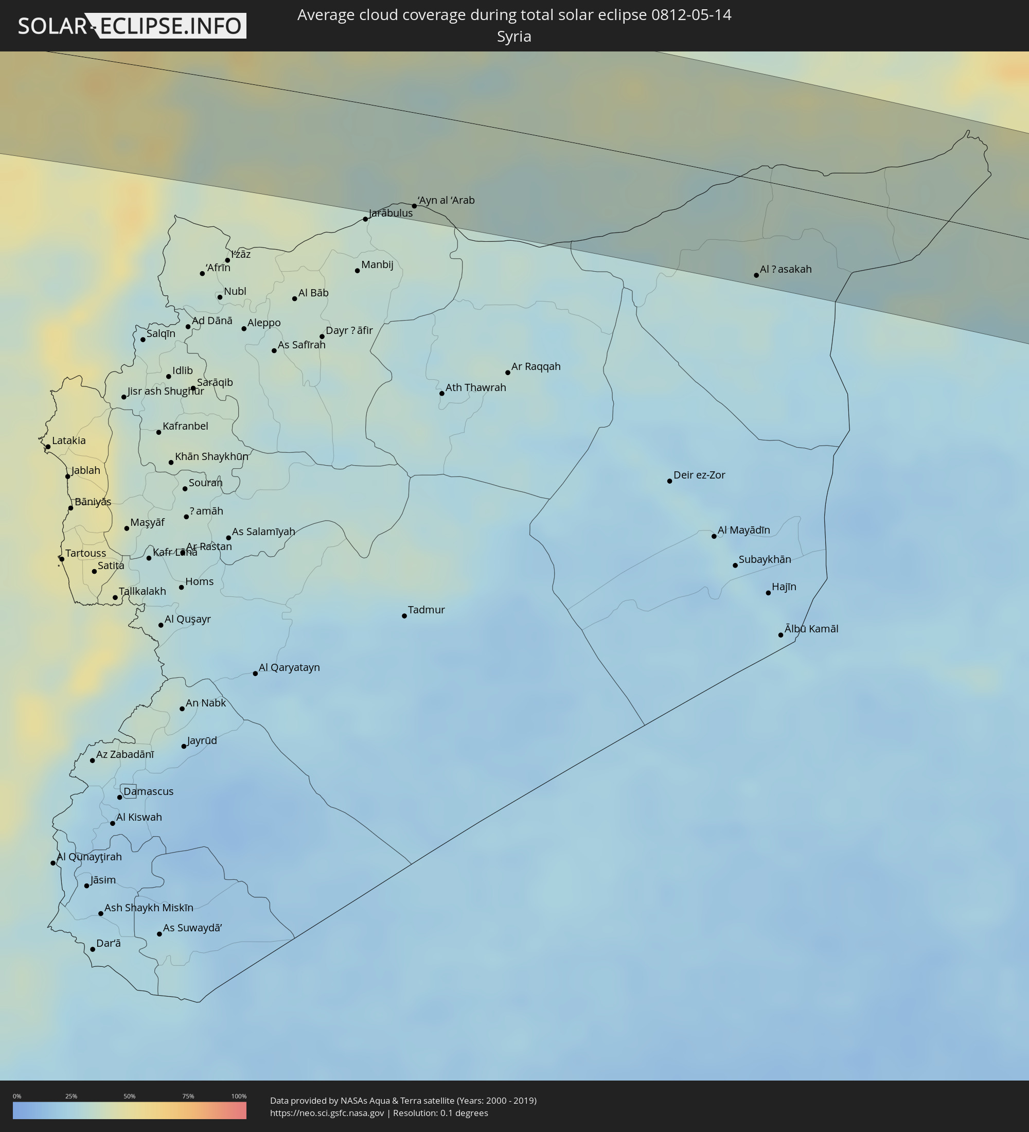 Syrien
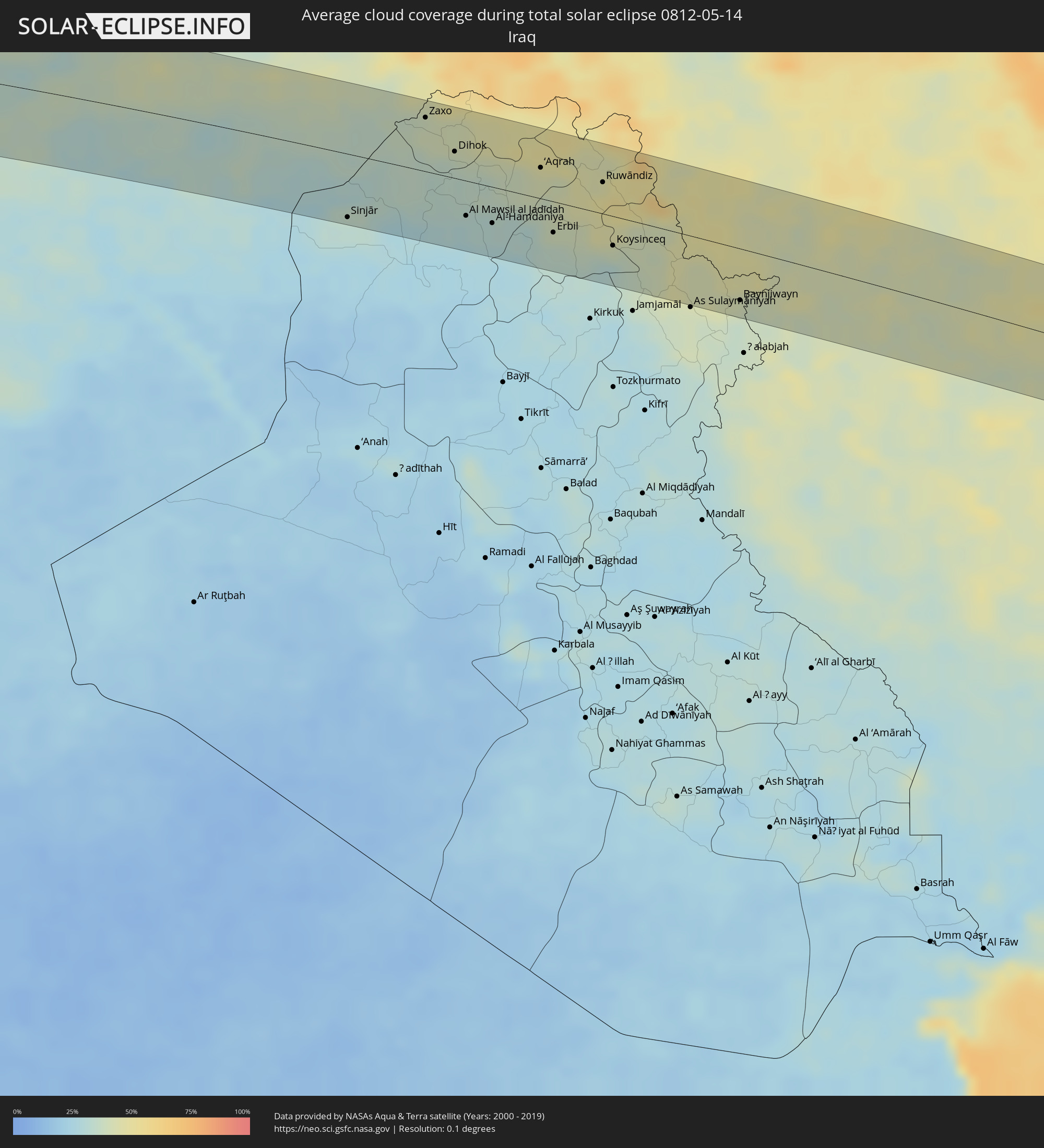 Irak
Irak
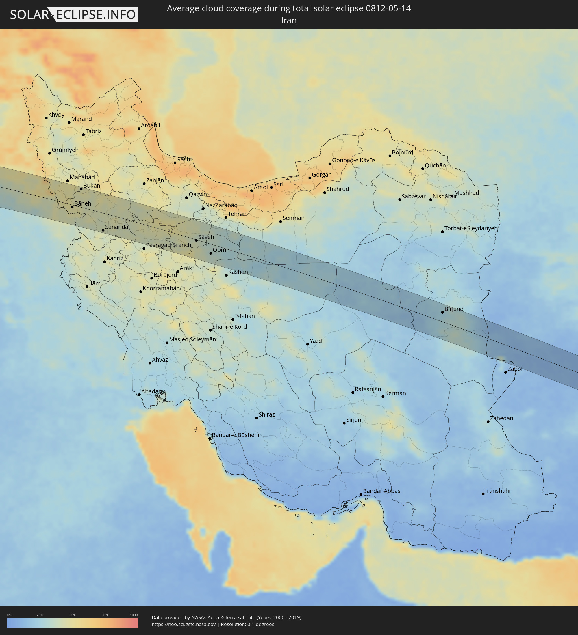 Iran
Iran
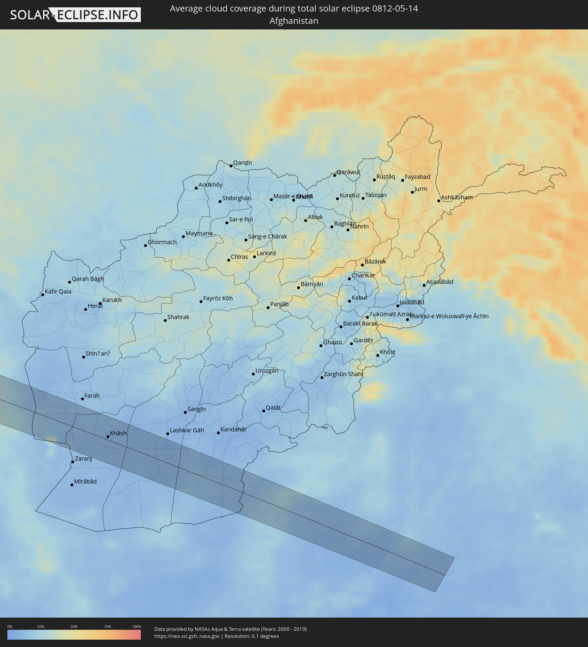 Afghanistan
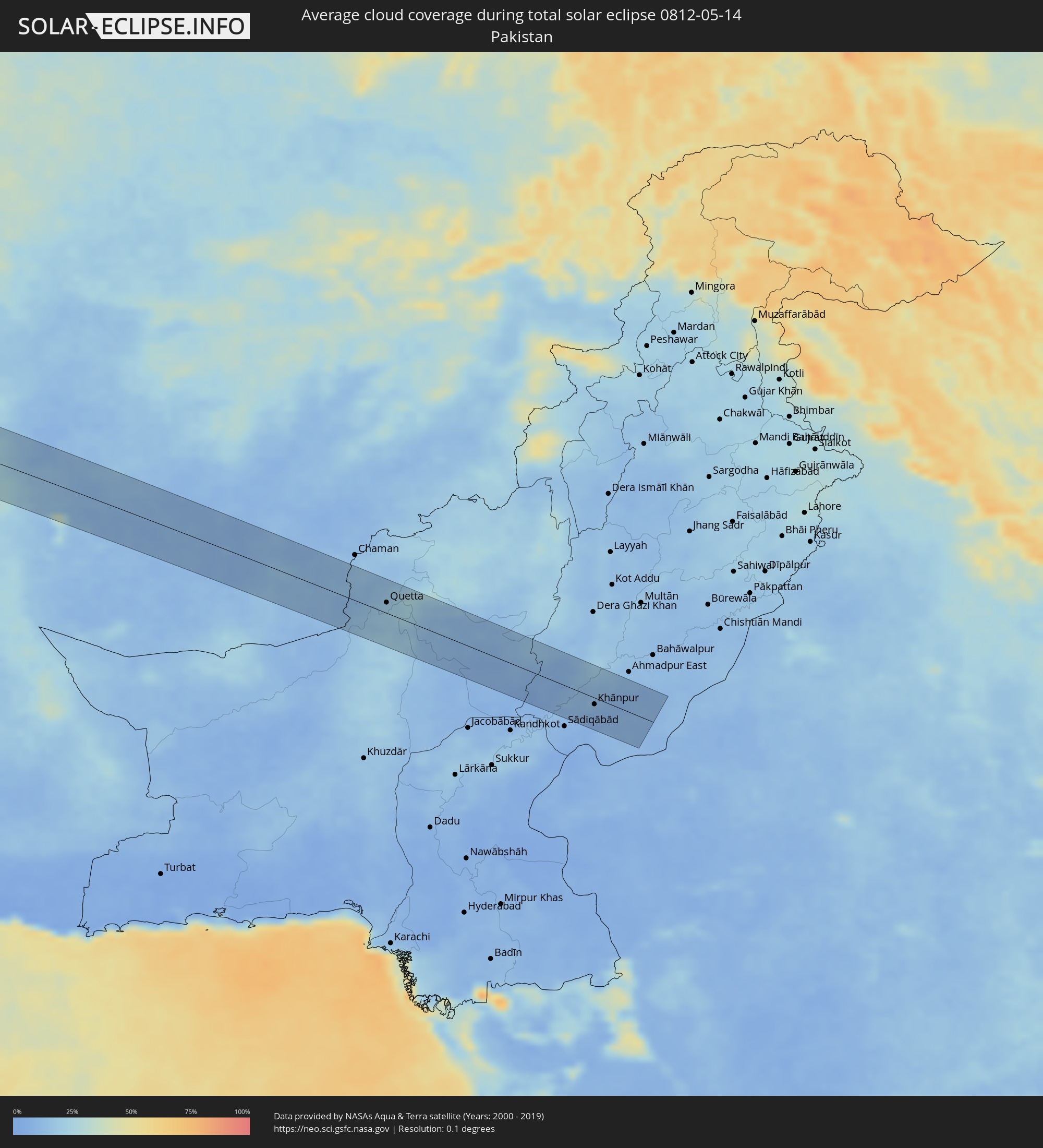 Pakistan
Orte im Finsternispfad
Die nachfolgene Tabelle zeigt Städte und Orte mit mehr als 5.000 Einwohnern, die sich im Finsternispfad befinden. Städte mit mehr als 100.000 Einwohnern sind dick gekennzeichnet. Mit einem Klick auf den Ort öffnet sich eine Detailkarte die die Lage des jeweiligen Ortes zusammen mit dem Verlauf der zentralen Finsternis präsentiert.
| Ort | Typ | Dauer der Verfinsterung | Ortszeit bei maximaler Verfinsterung | Entfernung zur Zentrallinie | Ø Bewölkung |
|
Manicoré, Amazonas
|
total | - | 06:21:33 UTC-04:02 | 33 km | 79% |
|
Itaituba, Pará
|
total | - | 07:11:06 UTC-03:13 | 42 km | 82% |
|
Porto de Moz, Pará
|
total | - | 07:13:28 UTC-03:13 | 31 km | 81% |
|
Gurupá, Pará
|
total | - | 07:13:52 UTC-03:13 | 34 km | 86% |
|
Portel, Pará
|
total | - | 07:13:33 UTC-03:13 | 60 km | 69% |
|
Breves, Pará
|
total | - | 07:13:50 UTC-03:13 | 53 km | 74% |
|
Soure, Pará
|
total | - | 07:15:11 UTC-03:13 | 62 km | 68% |
|
Ribeira Grande, Ribeira Grande
|
total | - | 09:38:47 UTC-01:34 | 3 km | 42% |
|
Porto Novo, Porto Novo
|
total | - | 09:38:30 UTC-01:34 | 11 km | 31% |
|
Pombas, Paul
|
total | - | 09:38:48 UTC-01:34 | 3 km | 58% |
|
Mindelo, São Vicente
|
total | - | 09:38:23 UTC-01:34 | 28 km | 27% |
 Laayoune Plage
|
total | - | 10:57:56 UTC-00:52 | 44 km | 27% |
|
Laâyoune / El Aaiún, Oued Ed-Dahab-Lagouira
|
total | - | 10:58:27 UTC-00:52 | 34 km | 21% |
|
Tan-Tan, Guelmim-Es Smara
|
total | - | 11:27:18 UTC-00:30 | 23 km | 36% |
|
Sidi Ifni, Souss-Massa-Drâa
|
total | - | 11:30:46 UTC-00:30 | 53 km | 54% |
|
Guelmim, Guelmim-Es Smara
|
total | - | 11:30:21 UTC-00:30 | 11 km | 24% |
|
Tiznit, Souss-Massa-Drâa
|
total | - | 11:32:11 UTC-00:30 | 57 km | 26% |
|
Ouarzazat, Souss-Massa-Drâa
|
total | - | 11:39:59 UTC-00:30 | 16 km | 22% |
|
Ifrane, Tadla-Azilal
|
total | - | 11:42:18 UTC-00:30 | 61 km | 36% |
|
Tinghir, Souss-Massa-Drâa
|
total | - | 11:43:45 UTC-00:30 | 3 km | 25% |
|
Midelt, Meknès-Tafilalet
|
total | - | 11:47:04 UTC-00:30 | 76 km | 31% |
|
Saïda, Saida
|
total | - | 12:39:41 UTC+00:09 | 74 km | 36% |
|
Aïn Oussera, Djelfa
|
total | - | 12:46:04 UTC+00:09 | 36 km | 32% |
|
Djelfa, Djelfa
|
total | - | 12:46:07 UTC+00:09 | 56 km | 31% |
|
M’Sila, M'Sila
|
total | - | 12:49:42 UTC+00:09 | 9 km | 34% |
|
Bordj Bou Arreridj, Bordj Bou Arréridj
|
total | - | 12:50:26 UTC+00:09 | 40 km | 40% |
|
Sétif, Sétif
|
total | - | 12:51:52 UTC+00:09 | 33 km | 43% |
|
El Eulma, Sétif
|
total | - | 12:52:24 UTC+00:09 | 20 km | 43% |
|
Batna, Batna
|
total | - | 12:52:59 UTC+00:09 | 57 km | 38% |
|
Constantine, Constantine
|
total | - | 12:54:27 UTC+00:09 | 16 km | 43% |
|
Skikda, Skikda
|
total | - | 12:55:22 UTC+00:09 | 62 km | 44% |
|
Oum el Bouaghi, Oum el Bouaghi
|
total | - | 12:55:09 UTC+00:09 | 50 km | 38% |
|
Aïn Beïda, Oum el Bouaghi
|
total | - | 12:55:41 UTC+00:09 | 66 km | 41% |
|
Guelma, Guelma
|
total | - | 12:56:09 UTC+00:09 | 4 km | 46% |
|
Annaba, Annaba
|
total | - | 12:57:06 UTC+00:09 | 42 km | 47% |
|
Souk Ahras, Souk Ahras
|
total | - | 12:57:07 UTC+00:09 | 28 km | 45% |
|
El Kef, Kef
|
total | - | 12:58:35 UTC+00:09 | 59 km | 44% |
|
Jendouba, Jundūbah
|
total | - | 12:58:55 UTC+00:09 | 26 km | 44% |
|
Béja, Bājah
|
total | - | 12:59:50 UTC+00:09 | 12 km | 46% |
|
Medjez el Bab, Bājah
|
total | - | 13:00:39 UTC+00:09 | 30 km | 46% |
|
Mateur, Banzart
|
total | - | 13:00:56 UTC+00:09 | 11 km | 52% |
|
Menzel Bourguiba, Banzart
|
total | - | 13:01:14 UTC+00:09 | 20 km | 52% |
|
Bizerte, Banzart
|
total | - | 13:01:27 UTC+00:09 | 31 km | 49% |
|
La Mohammedia, Tūnis
|
total | - | 13:01:45 UTC+00:09 | 40 km | 46% |
|
Tunis, Tūnis
|
total | - | 13:01:50 UTC+00:09 | 24 km | 47% |
|
Al Marsá, Tūnis
|
total | - | 13:02:10 UTC+00:09 | 21 km | 51% |
|
Hammam-Lif, Tūnis
|
total | - | 13:02:08 UTC+00:09 | 38 km | 48% |
|
Takelsa, Nābul
|
total | - | 13:02:44 UTC+00:09 | 38 km | 44% |
|
Dar Chabanne, Nābul
|
total | - | 13:02:51 UTC+00:09 | 75 km | 51% |
|
Korba, Nābul
|
total | - | 13:03:06 UTC+00:09 | 65 km | 52% |
|
Kélibia, Nābul
|
total | - | 13:03:40 UTC+00:09 | 41 km | 50% |
|
Marsala, Sicily
|
total | - | 13:57:13 UTC+01:00 | 36 km | 46% |
|
Trapani, Sicily
|
total | - | 13:57:27 UTC+01:00 | 59 km | 44% |
|
Mazara del Vallo, Sicily
|
total | - | 13:57:28 UTC+01:00 | 18 km | 49% |
|
Alcamo, Sicily
|
total | - | 13:58:15 UTC+01:00 | 47 km | 43% |
|
Sciacca, Sicily
|
total | - | 13:58:21 UTC+01:00 | 7 km | 47% |
|
Palermo, Sicily
|
total | - | 13:58:58 UTC+01:00 | 57 km | 49% |
|
Bagheria, Sicily
|
total | - | 13:59:17 UTC+01:00 | 49 km | 43% |
|
Licata, Sicily
|
total | - | 13:59:53 UTC+01:00 | 65 km | 43% |
|
Caltanissetta, Sicily
|
total | - | 14:00:11 UTC+01:00 | 25 km | 48% |
|
Gela, Sicily
|
total | - | 14:00:26 UTC+01:00 | 73 km | 48% |
|
Caltagirone, Sicily
|
total | - | 14:00:59 UTC+01:00 | 59 km | 48% |
|
Paternò, Sicily
|
total | - | 14:01:45 UTC+01:00 | 29 km | 45% |
|
Catania, Sicily
|
total | - | 14:02:03 UTC+01:00 | 39 km | 49% |
|
Acireale, Sicily
|
total | - | 14:02:14 UTC+01:00 | 28 km | 50% |
|
Messina, Sicily
|
total | - | 14:03:00 UTC+01:00 | 31 km | 62% |
|
Préveza, Epirus
|
total | - | 14:46:38 UTC+01:34 | 68 km | 45% |
|
Agrínio, West Greece
|
total | - | 14:47:45 UTC+01:34 | 27 km | 46% |
|
Pátra, West Greece
|
total | - | 14:48:20 UTC+01:34 | 16 km | 49% |
|
Aígio, West Greece
|
total | - | 14:48:53 UTC+01:34 | 17 km | 50% |
|
Lamía, Central Greece
|
total | - | 14:49:17 UTC+01:34 | 54 km | 53% |
|
Livadeiá, Central Greece
|
total | - | 14:50:05 UTC+01:34 | 2 km | 52% |
|
Kórinthos, Peloponnese
|
total | - | 14:50:19 UTC+01:34 | 54 km | 43% |
|
Thívai, Central Greece
|
total | - | 14:50:47 UTC+01:34 | 12 km | 49% |
|
Salamína, Attica
|
total | - | 14:51:10 UTC+01:34 | 52 km | 50% |
|
Chalkída, Central Greece
|
total | - | 14:51:11 UTC+01:34 | 3 km | 45% |
|
Athens, Attica
|
total | - | 14:51:30 UTC+01:34 | 51 km | 46% |
|
Voúla, Attica
|
total | - | 14:51:37 UTC+01:34 | 66 km | 53% |
|
Néa Erythraía, Attica
|
total | - | 14:51:37 UTC+01:34 | 38 km | 49% |
|
Artémida, Attica
|
total | - | 14:51:55 UTC+01:34 | 52 km | 43% |
|
Chios, North Aegean
|
total | - | 14:54:55 UTC+01:34 | 7 km | 37% |
|
İzmir, İzmir
|
total | - | 15:18:22 UTC+01:56 | 1 km | 45% |
|
Manisa, Manisa
|
total | - | 15:18:40 UTC+01:56 | 24 km | 47% |
|
Aydın, Aydın
|
total | - | 15:19:34 UTC+01:56 | 60 km | 38% |
|
Denizli, Denizli
|
total | - | 15:21:17 UTC+01:56 | 62 km | 40% |
|
Uşak, Uşak
|
total | - | 15:21:15 UTC+01:56 | 40 km | 45% |
|
Isparta, Isparta
|
total | - | 15:23:10 UTC+01:56 | 53 km | 49% |
|
Konya, Konya
|
total | - | 15:25:26 UTC+01:56 | 25 km | 49% |
|
Aksaray, Aksaray
|
total | - | 15:26:52 UTC+01:56 | 47 km | 44% |
|
Kahramanmaraş, Kahramanmaraş
|
total | - | 15:30:24 UTC+01:56 | 3 km | 36% |
|
Gaziantep, Gaziantep
|
total | - | 15:31:11 UTC+01:56 | 54 km | 41% |
|
Adıyaman, Adıyaman
|
total | - | 15:31:33 UTC+01:56 | 37 km | 37% |
|
‘Ayn al ‘Arab, Aleppo
|
total | - | 16:00:30 UTC+02:25 | 57 km | 33% |
|
Şanlıurfa, Şanlıurfa
|
total | - | 15:32:27 UTC+01:56 | 20 km | 36% |
|
Siverek, Şanlıurfa
|
total | - | 15:32:30 UTC+01:56 | 53 km | 37% |
|
Viranşehir, Şanlıurfa
|
total | - | 15:33:16 UTC+01:56 | 2 km | 32% |
|
Kızıltepe, Mardin
|
total | - | 15:34:00 UTC+01:56 | 13 km | 31% |
|
Ad Darbāsīyah, Al-Hasakah
|
total | - | 16:02:24 UTC+02:25 | 2 km | 33% |
|
Al Ḩasakah, Al-Hasakah
|
total | - | 16:02:54 UTC+02:25 | 59 km | 28% |
|
Sinjār, Nīnawá
|
total | - | 16:36:21 UTC+02:57 | 57 km | 32% |
|
Zaxo, Dahūk
|
total | - | 16:36:22 UTC+02:57 | 48 km | 40% |
|
Dihok, Dahūk
|
total | - | 16:36:48 UTC+02:57 | 24 km | 38% |
|
Sīnah, Dahūk
|
total | - | 16:36:53 UTC+02:57 | 18 km | 35% |
|
Al Mawşil al Jadīdah, Nīnawá
|
total | - | 16:37:17 UTC+02:57 | 32 km | 30% |
|
Mosul, Nīnawá
|
total | - | 16:37:17 UTC+02:57 | 31 km | 30% |
|
Tallkayf, Nīnawá
|
total | - | 16:37:11 UTC+02:57 | 14 km | 32% |
|
Al-Hamdaniya, Nīnawá
|
total | - | 16:37:32 UTC+02:57 | 33 km | 32% |
|
‘Aqrah, Nīnawá
|
total | - | 16:37:33 UTC+02:57 | 28 km | 43% |
|
Erbil, Arbīl
|
total | - | 16:38:03 UTC+02:57 | 28 km | 35% |
|
Ruwāndiz, Arbīl
|
total | - | 16:38:05 UTC+02:57 | 28 km | 50% |
|
Koysinceq, Arbīl
|
total | - | 16:38:33 UTC+02:57 | 27 km | 38% |
|
Piranshahr, Āz̄ārbāyjān-e Gharbī
|
total | - | 17:06:34 UTC+03:25 | 51 km | 48% |
|
Bāneh, Kordestān
|
total | - | 17:07:35 UTC+03:25 | 8 km | 47% |
|
Baynjiwayn, As Sulaymānīyah
|
total | - | 16:39:46 UTC+02:57 | 47 km | 39% |
|
Būkān, Āz̄ārbāyjān-e Gharbī
|
total | - | 17:07:23 UTC+03:25 | 56 km | 48% |
|
Saqqez, Kordestān
|
total | - | 17:07:38 UTC+03:25 | 28 km | 42% |
|
Sanandaj, Kordestān
|
total | - | 17:08:47 UTC+03:25 | 55 km | 42% |
|
Bījār, Kordestān
|
total | - | 17:08:43 UTC+03:25 | 18 km | 43% |
|
Qorveh, Kordestān
|
total | - | 17:09:22 UTC+03:25 | 52 km | 42% |
|
Tafresh, Markazi
|
total | - | 17:10:53 UTC+03:25 | 47 km | 50% |
|
Sāveh, Markazi
|
total | - | 17:10:48 UTC+03:25 | 3 km | 40% |
|
Qom, Qom
|
total | - | 17:11:19 UTC+03:25 | 30 km | 34% |
|
Eqbālīyeh, Tehrān
|
total | - | 17:11:06 UTC+03:25 | 59 km | 33% |
|
Tabas, Yazd
|
total | - | 17:14:11 UTC+03:25 | 34 km | 21% |
|
Bīrjand, Khorāsān-e Jonūbī
|
total | - | 17:15:11 UTC+03:25 | 29 km | 24% |
|
Khāsh, Nimroz
|
total | - | 17:50:46 UTC+04:00 | 7 km | 9% |
|
Markaz-e Ḩukūmat-e Darwēshān, Helmand
|
total | - | 17:51:05 UTC+04:00 | 14 km | 11% |
|
Mastung, Balochistān
|
total | - | 18:20:03 UTC+04:28 | 31 km | 20% |
|
Kot Malik Barkhurdār, Balochistān
|
total | - | 18:19:47 UTC+04:28 | 16 km | 19% |
|
Quetta, Balochistān
|
total | - | 18:19:47 UTC+04:28 | 16 km | 19% |
|
Mach, Balochistān
|
total | - | 18:19:58 UTC+04:28 | 7 km | 16% |
|
Dādhar, Balochistān
|
total | - | 18:20:11 UTC+04:28 | 35 km | 12% |
|
Sibi, Balochistān
|
total | - | 18:20:07 UTC+04:28 | 20 km | 11% |
|
Harnai, Balochistān
|
total | - | 18:19:46 UTC+04:28 | 40 km | 12% |
|
Dera Bugti, Balochistān
|
total | - | 18:20:16 UTC+04:28 | 26 km | 8% |
|
Rojhān, Punjab
|
total | - | 18:20:21 UTC+04:28 | 32 km | 10% |
|
Rājanpur, Punjab
|
total | - | 18:20:03 UTC+04:28 | 24 km | 12% |
|
Kot Samāba, Punjab
|
total | - | 18:20:21 UTC+04:28 | 27 km | 8% |
|
Zāhir Pīr, Punjab
|
total | - | 18:20:11 UTC+04:28 | 2 km | 11% |
|
Khānpur, Punjab
|
total | - | 18:20:16 UTC+04:28 | 10 km | 9% |