Total solar eclipse of 05/14/0812
| Day of week: | Monday |
| Maximum duration of eclipse: | 04m00s |
| Maximum width of eclipse path: | 157 km |
| Saros cycle: | 99 |
| Coverage: | 100% |
| Magnitude: | 1.0464 |
| Gamma: | 0.1939 |
Wo kann man die Sonnenfinsternis vom 05/14/0812 sehen?
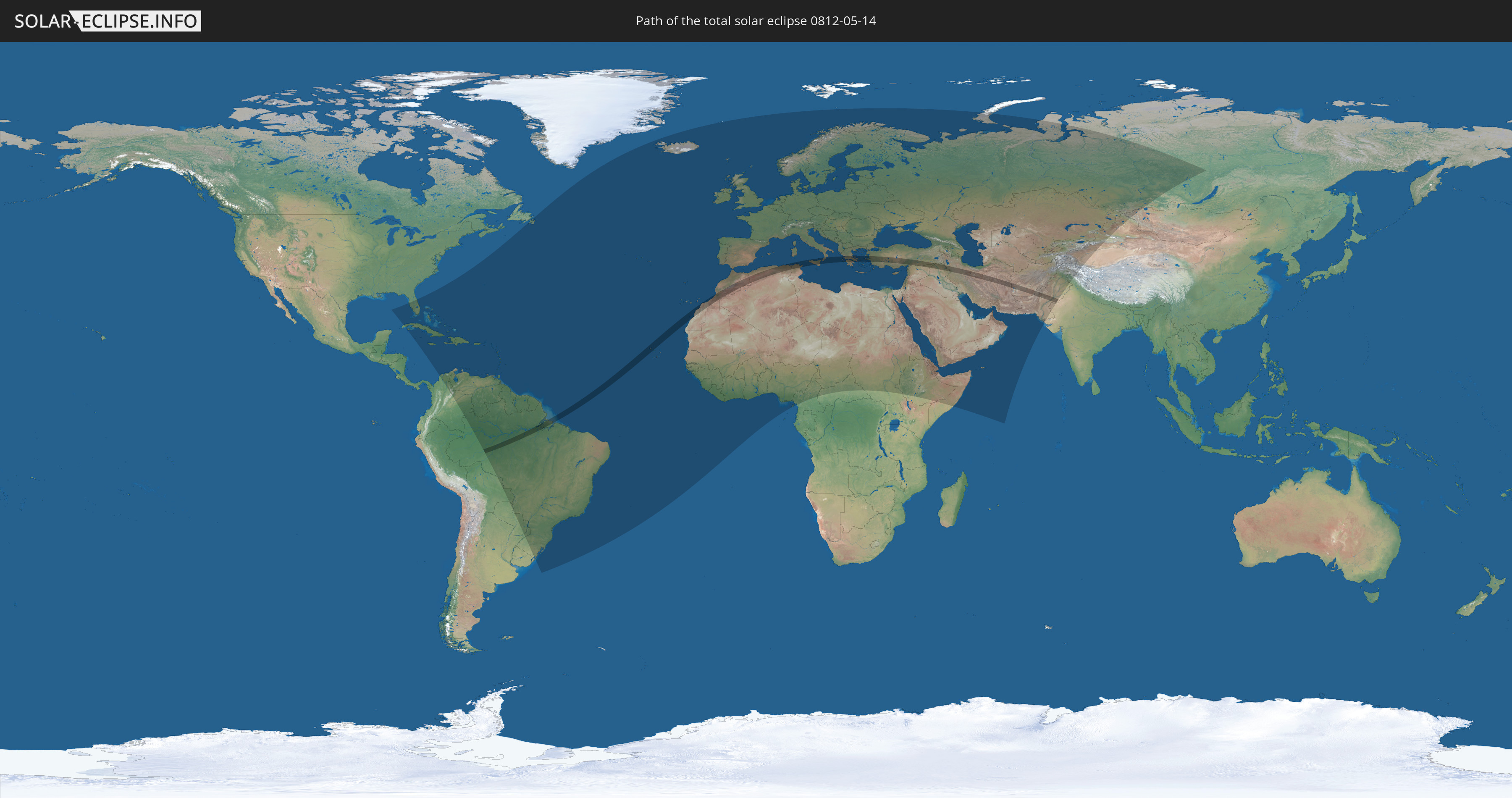
Die Sonnenfinsternis am 05/14/0812 kann man in 148 Ländern als partielle Sonnenfinsternis beobachten.
Der Finsternispfad verläuft durch 13 Länder. Nur in diesen Ländern ist sie als total Sonnenfinsternis zu sehen.
In den folgenden Ländern ist die Sonnenfinsternis total zu sehen
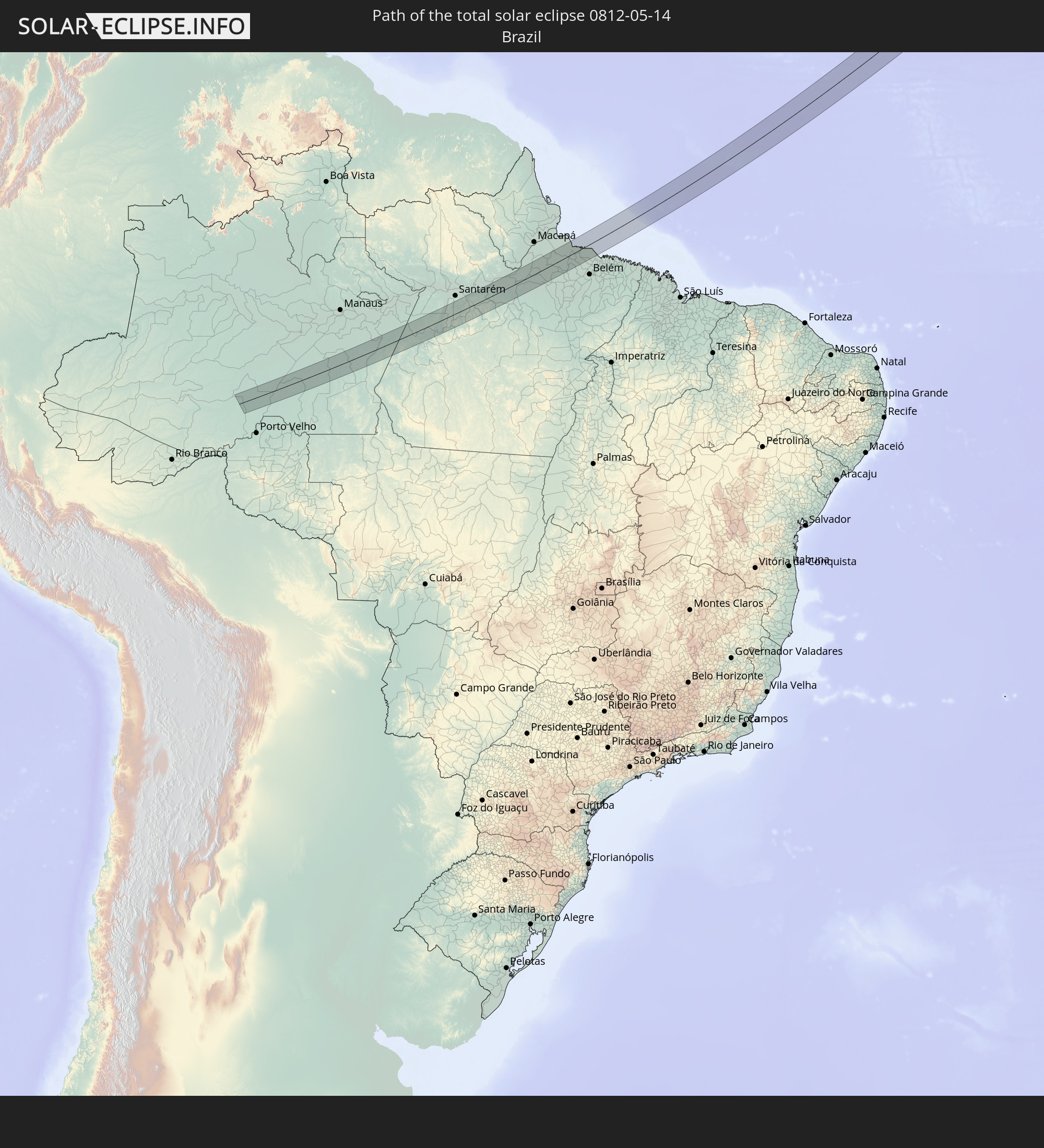 Brazil
 Cabo Verde
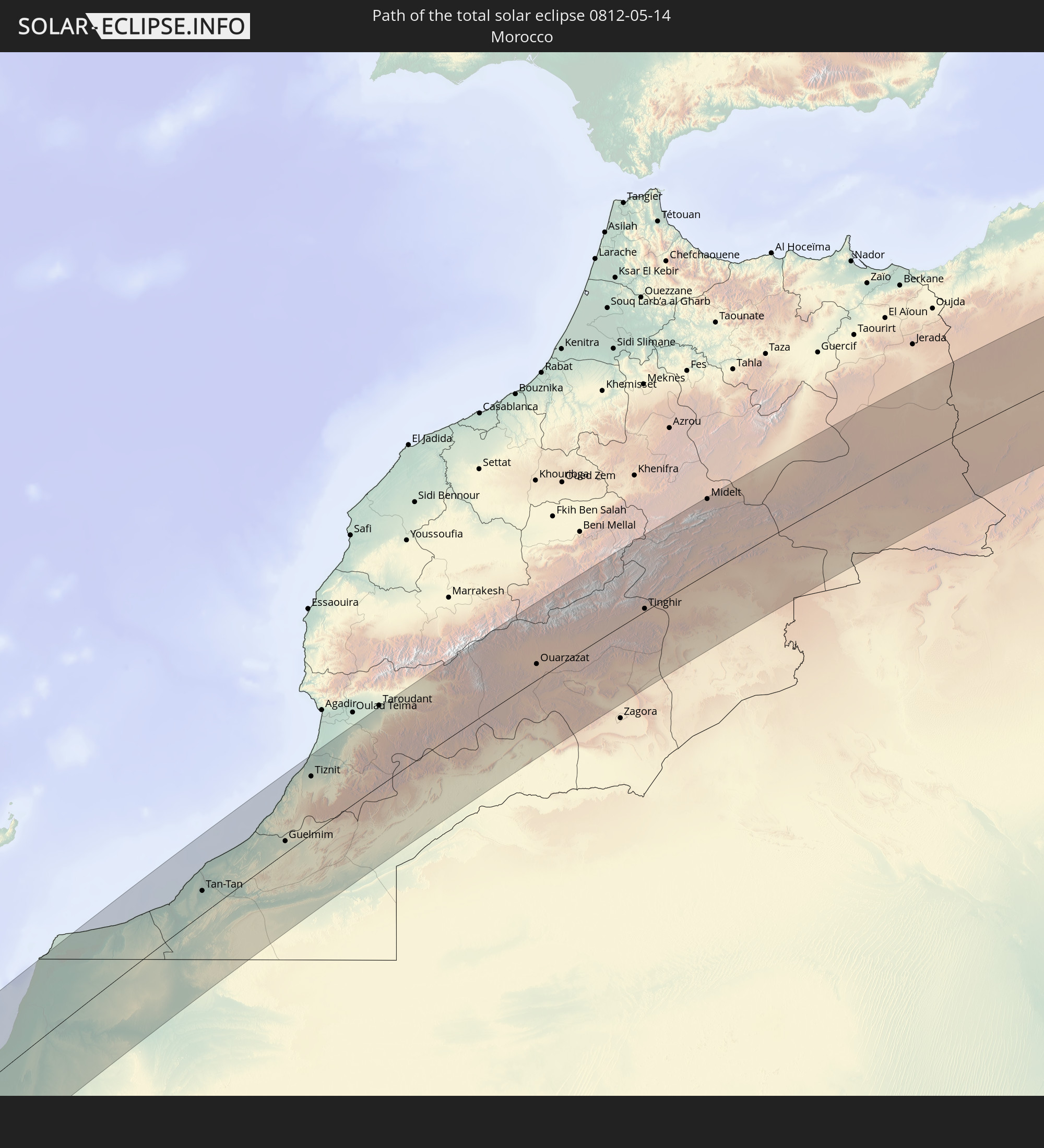 Morocco
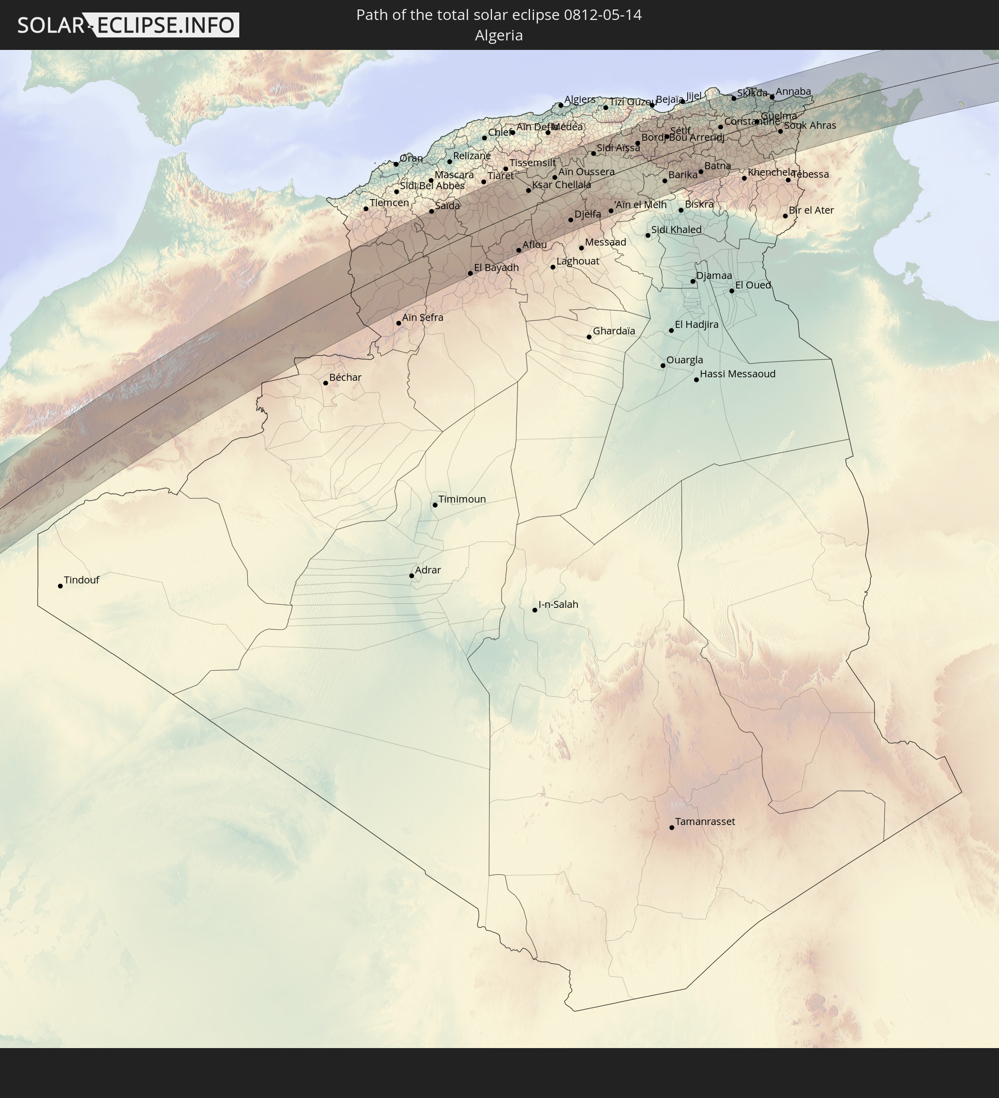 Algeria
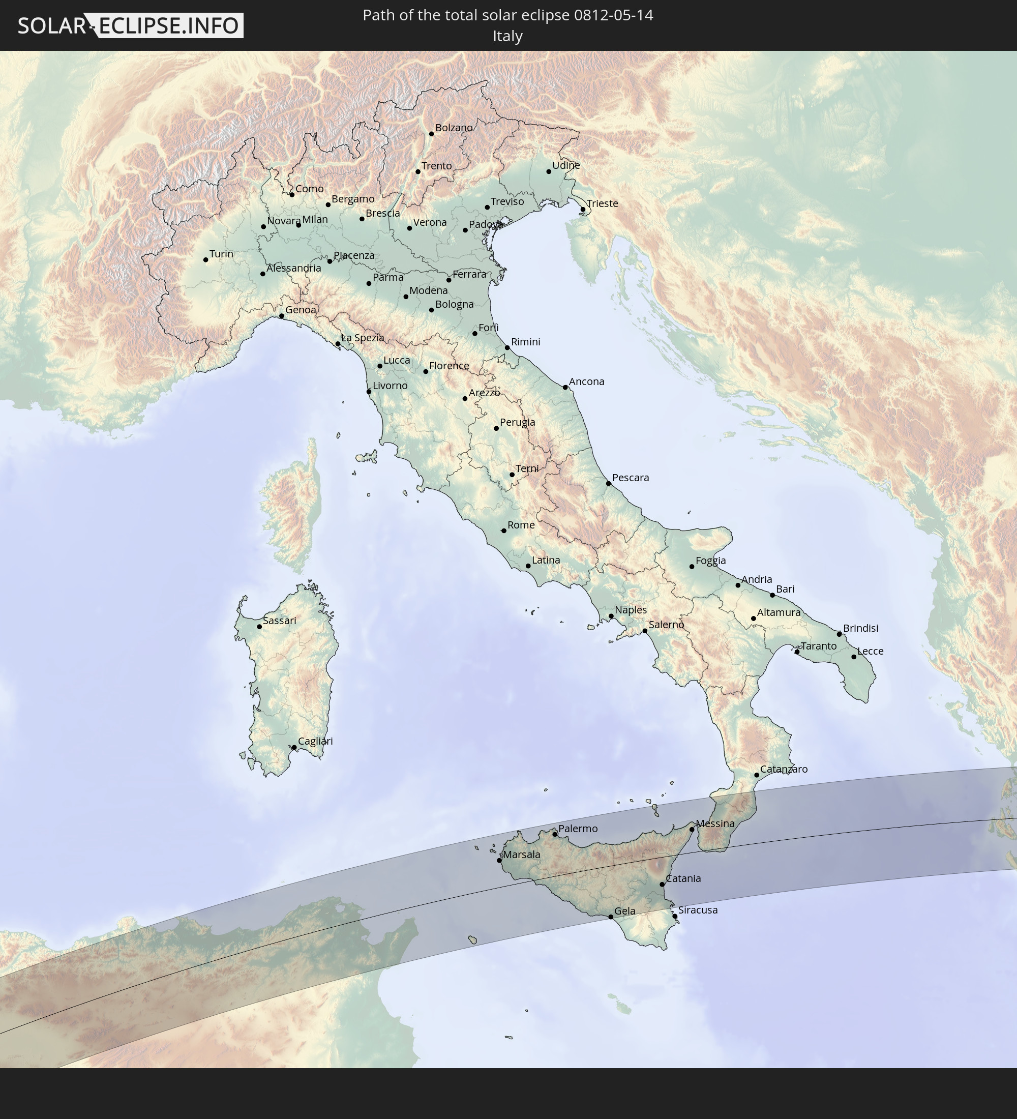 Italy
Italy
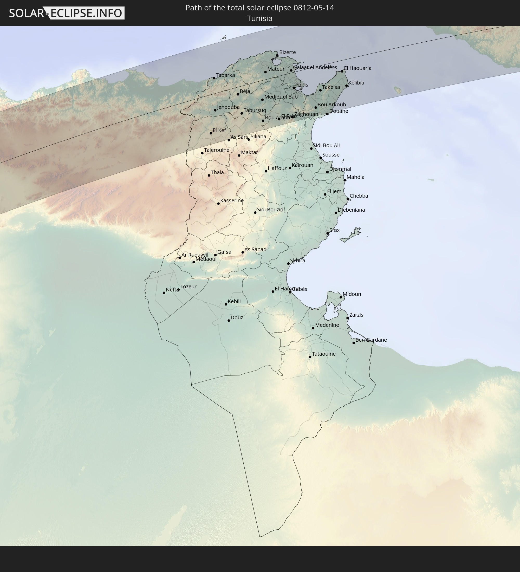 Tunisia
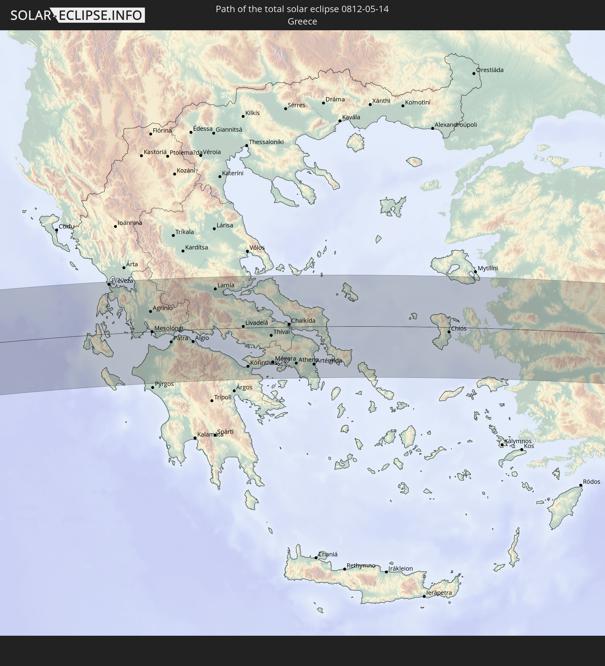 Greece
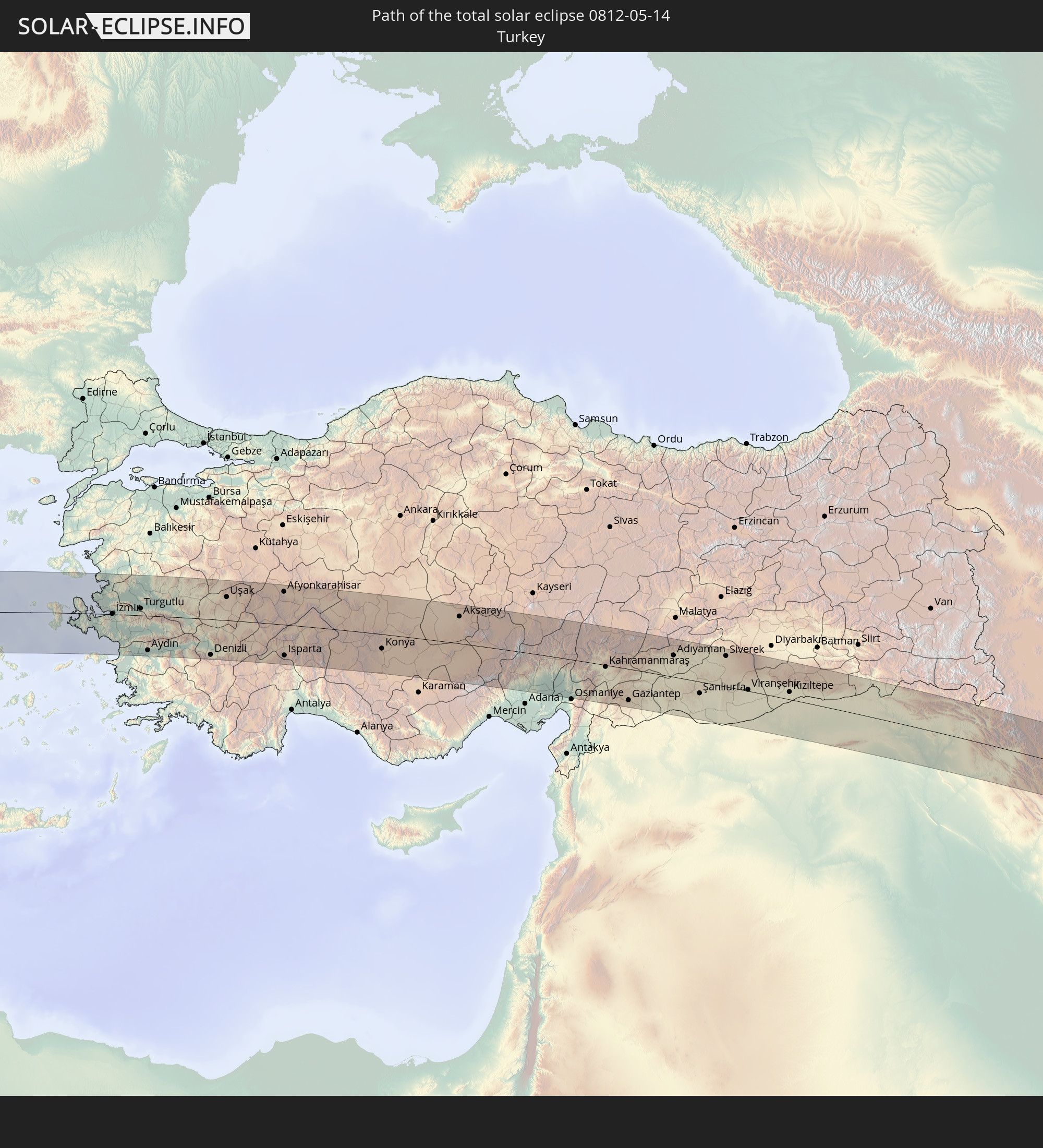 Turkey
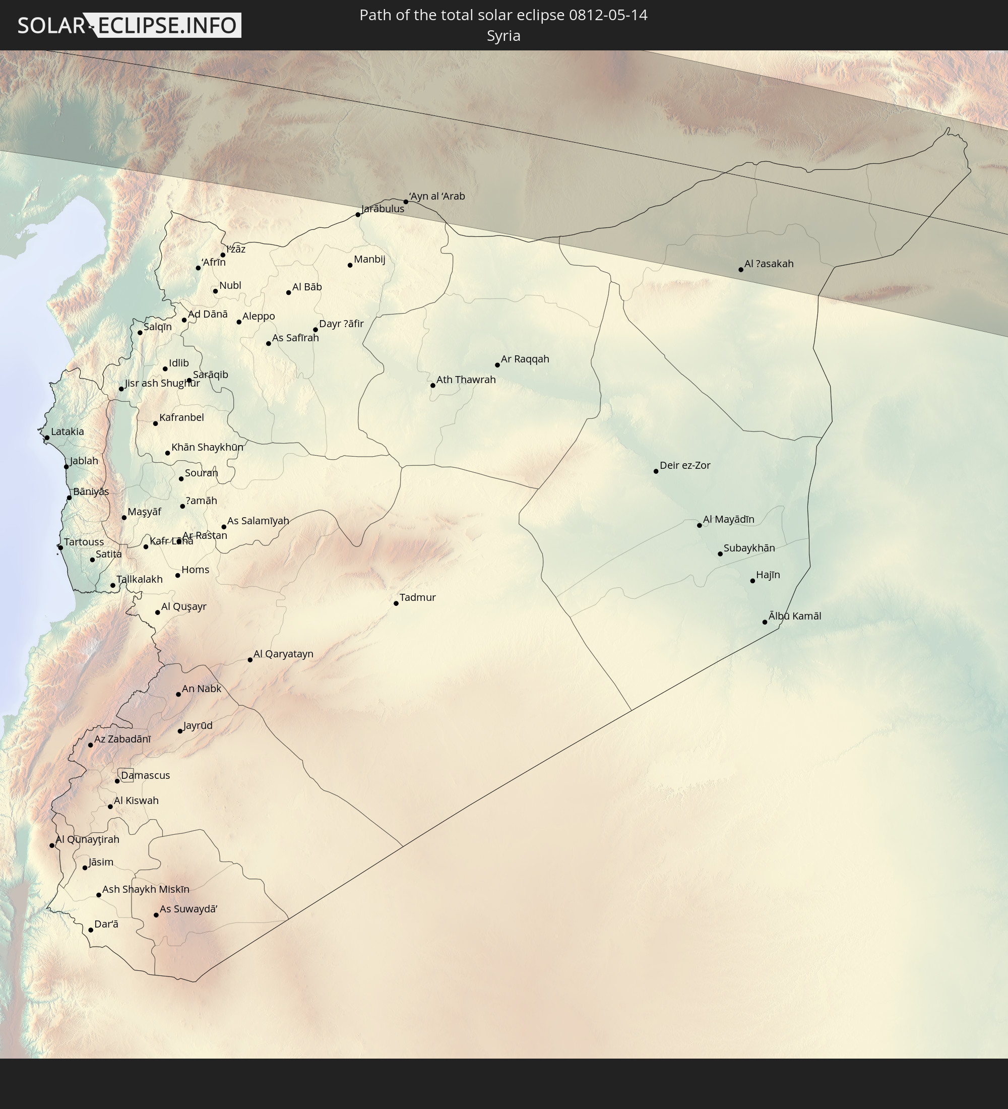 Syria
Syria
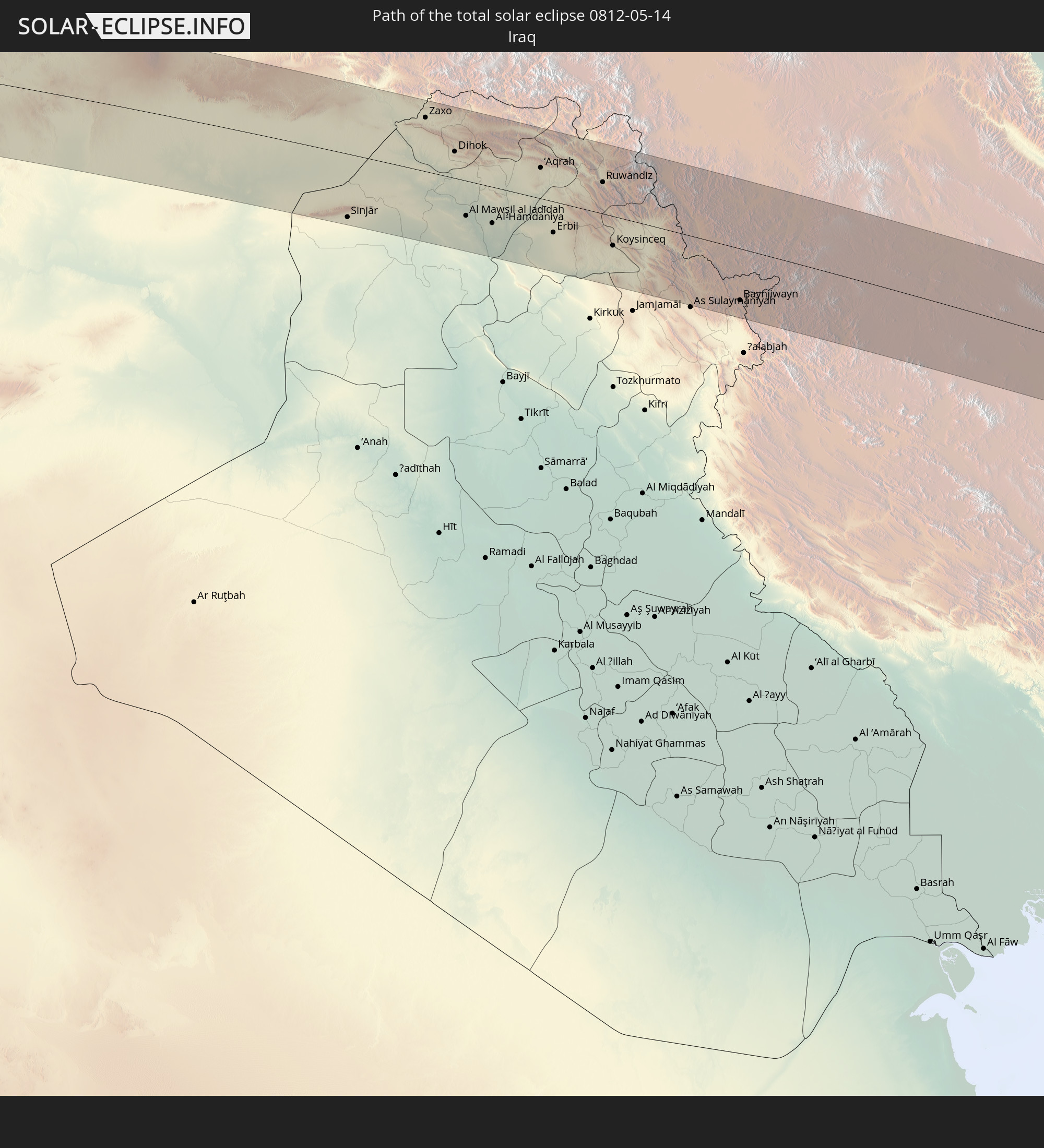 Iraq
Iraq
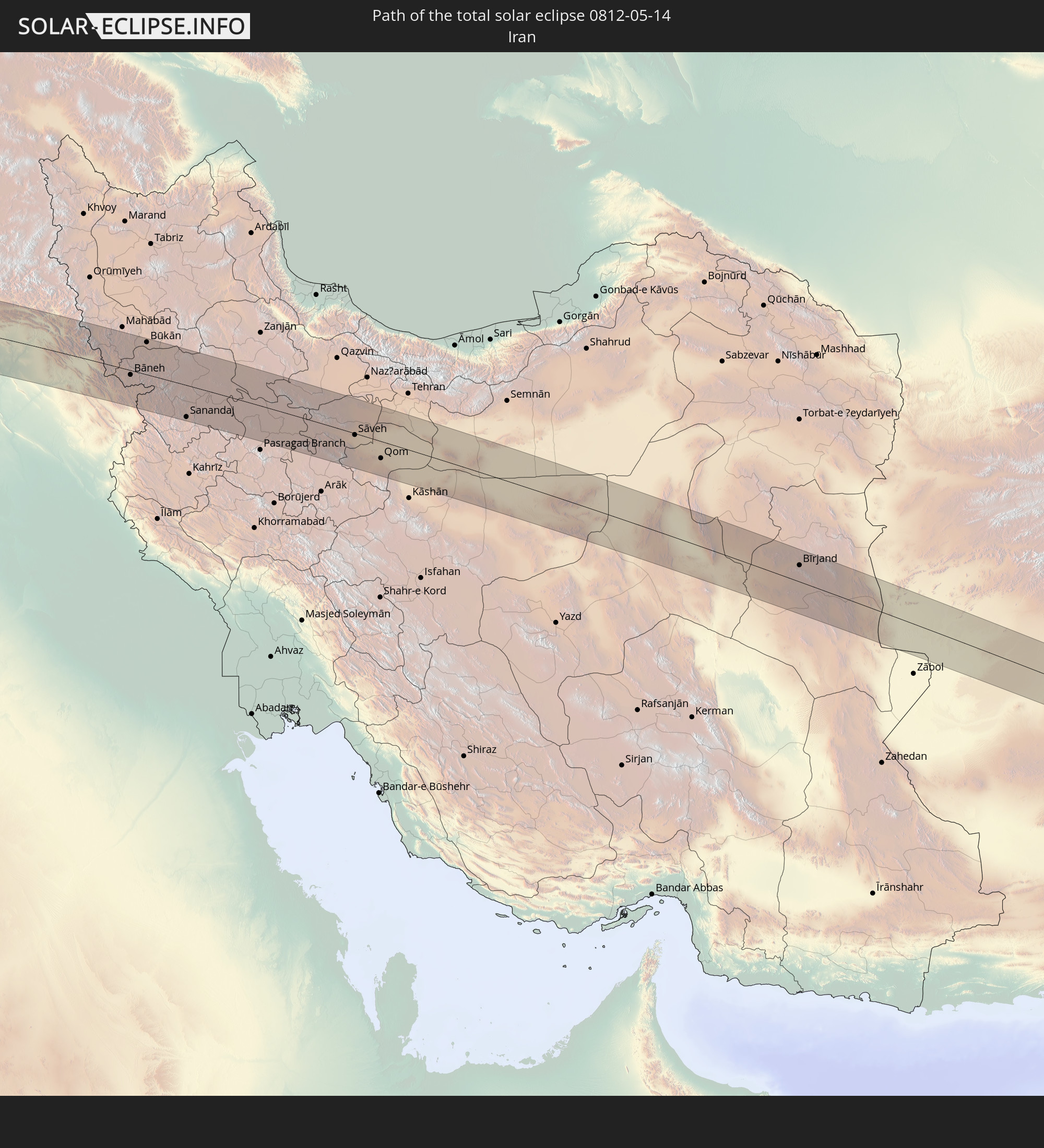 Iran
Iran
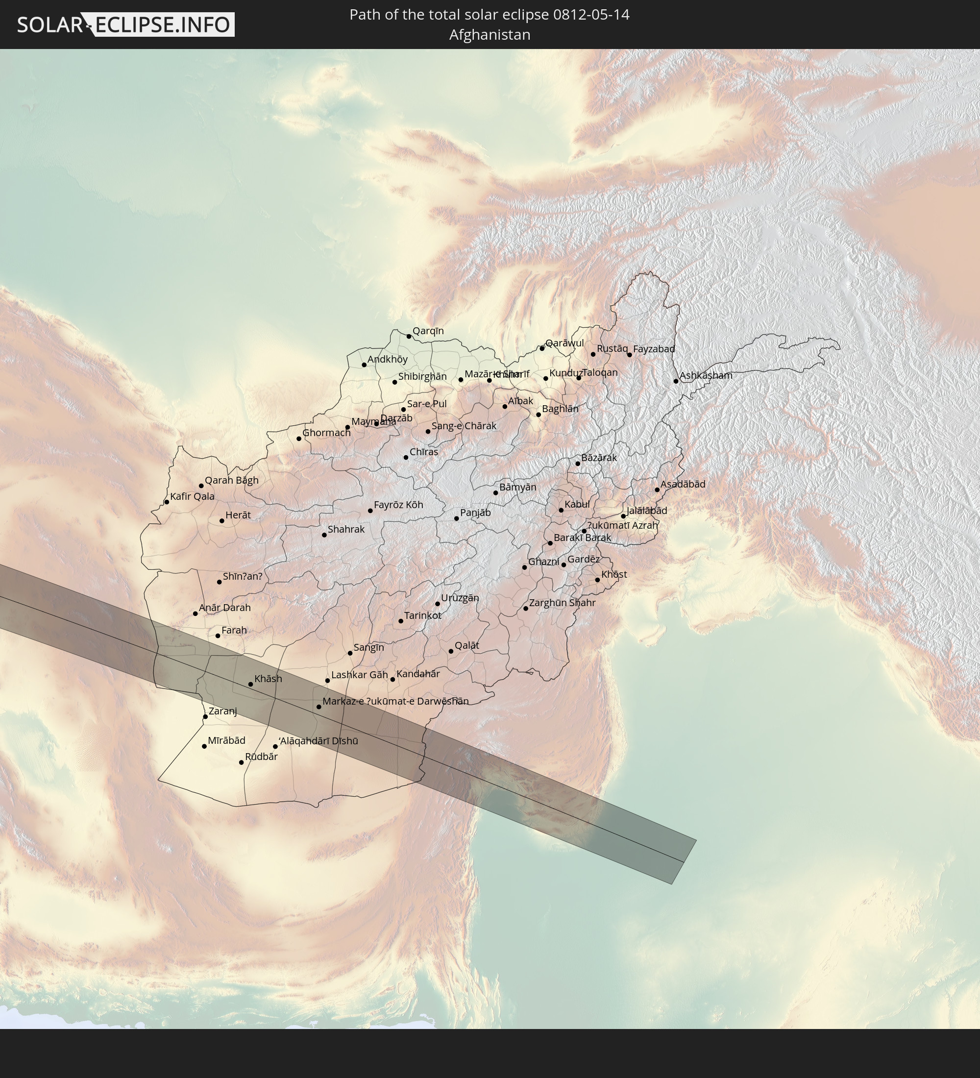 Afghanistan
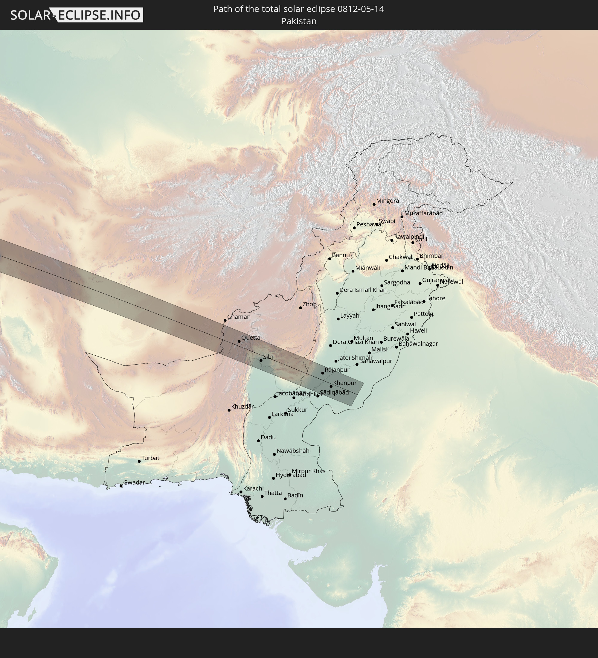 Pakistan
In den folgenden Ländern ist die Sonnenfinsternis partiell zu sehen
 Russia
 United States
 United States Minor Outlying Islands
 Canada
 Cuba
Cuba
 Colombia
 Cayman Islands
 The Bahamas
 Jamaica
 Haiti
Haiti
 Brazil
 Argentina
 Venezuela
 Turks and Caicos Islands
 Dominican Republic
 Aruba
Aruba
 Bolivia
 Puerto Rico
 United States Virgin Islands
 Bermuda
 British Virgin Islands
 Anguilla
 Collectivity of Saint Martin
 Saint Barthélemy
 Saint Kitts and Nevis
 Paraguay
 Antigua and Barbuda
 Montserrat
 Trinidad and Tobago
 Guadeloupe
 Grenada
 Dominica
 Saint Vincent and the Grenadines
 Guyana
 Martinique
 Saint Lucia
 Barbados
 Suriname
 French Guiana
 Portugal
 Cabo Verde
 Iceland
 Spain
Spain
 Senegal
 Mauritania
 The Gambia
 Guinea-Bissau
 Guinea
 Saint Helena, Ascension and Tristan da Cunha
 Sierra Leone
 Morocco
 Mali
Mali
 Liberia
 Republic of Ireland
 Algeria
 United Kingdom
 Ivory Coast
 Faroe Islands
 Burkina Faso
 Gibraltar
 France
 Isle of Man
 Ghana
Ghana
 Guernsey
 Jersey
 Togo
Togo
 Niger
Niger
 Benin
Benin
 Andorra
 Belgium
 Nigeria
 Netherlands
 Norway
 Equatorial Guinea
 Luxembourg
 Germany
 Switzerland
 Italy
Italy
 Monaco
 Tunisia
 Denmark
 Cameroon
 Libya
Libya
 Liechtenstein
 Austria
 Sweden
 Czechia
 San Marino
 Vatican City
 Slovenia
 Chad
Chad
 Croatia
 Poland
 Malta
Malta
 Central African Republic
 Bosnia and Herzegovina
 Hungary
 Slovakia
 Montenegro
 Serbia
 Albania
 Åland Islands
 Greece
 Romania
 Republic of Macedonia
 Finland
 Lithuania
 Latvia
 Estonia
 Sudan
Sudan
 Ukraine
 Bulgaria
 Belarus
 Egypt
Egypt
 Turkey
 Moldova
 Cyprus
 Ethiopia
 State of Palestine
 Israel
 Saudi Arabia
 Jordan
 Lebanon
 Syria
Syria
 Eritrea
 Iraq
Iraq
 Georgia
 Somalia
 Djibouti
 Yemen
Yemen
 Armenia
 Iran
Iran
 Azerbaijan
 Kazakhstan
 Kuwait
 Bahrain
 Qatar
Qatar
 United Arab Emirates
 Oman
Oman
 Turkmenistan
 Uzbekistan
 Afghanistan
 Pakistan
 Tajikistan
 India
India
 Kyrgyzstan
 China
China
 Mongolia
How will be the weather during the total solar eclipse on 05/14/0812?
Where is the best place to see the total solar eclipse of 05/14/0812?
The following maps show the average cloud coverage for the day of the total solar eclipse.
With the help of these maps, it is possible to find the place along the eclipse path, which has the best
chance of a cloudless sky.
Nevertheless, you should consider local circumstances and inform about the weather of your chosen
observation site.
The data is provided by NASAs satellites
AQUA and TERRA.
The cloud maps are averaged over a period of 19 years (2000 - 2019).
Detailed country maps
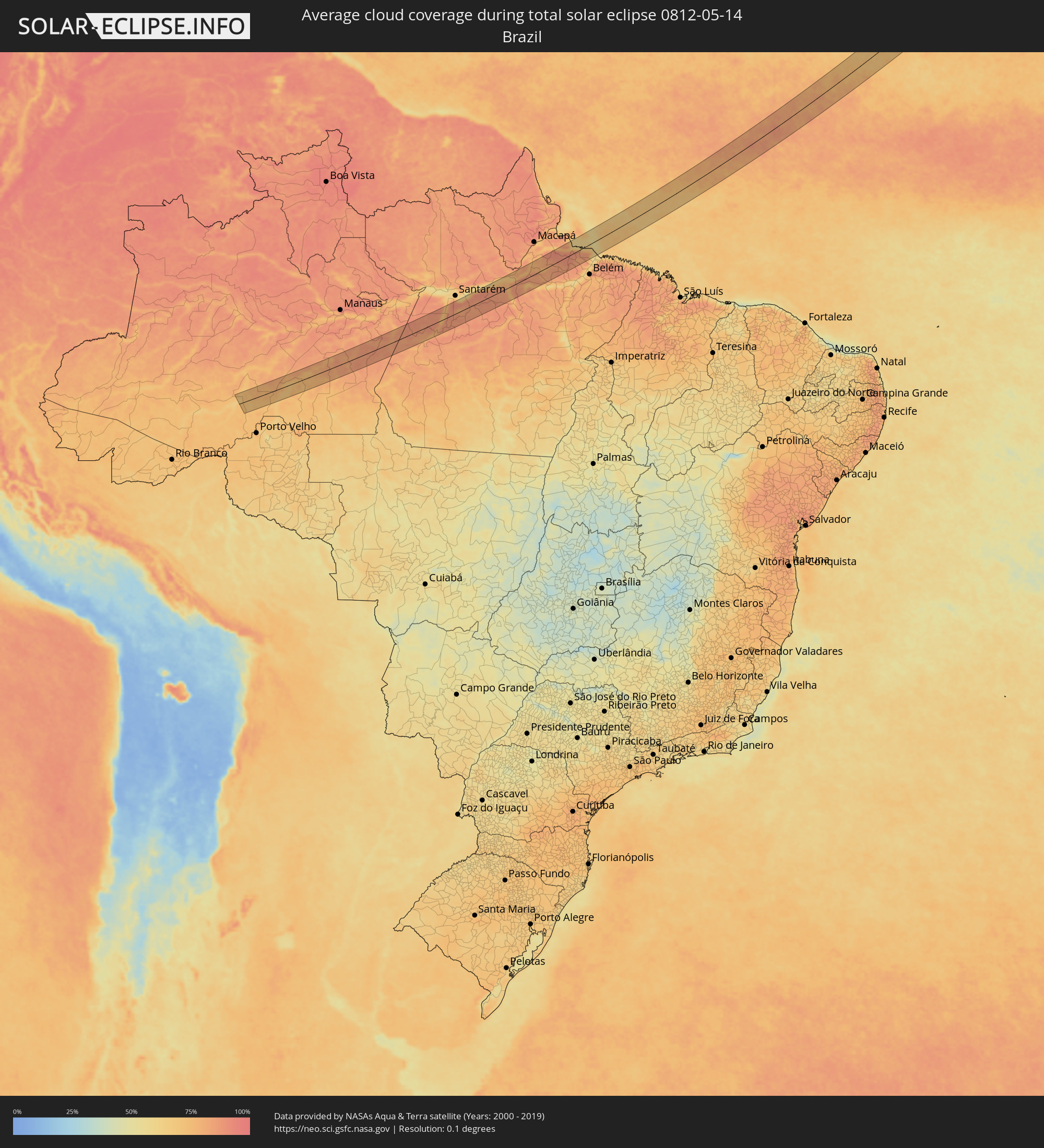 Brazil
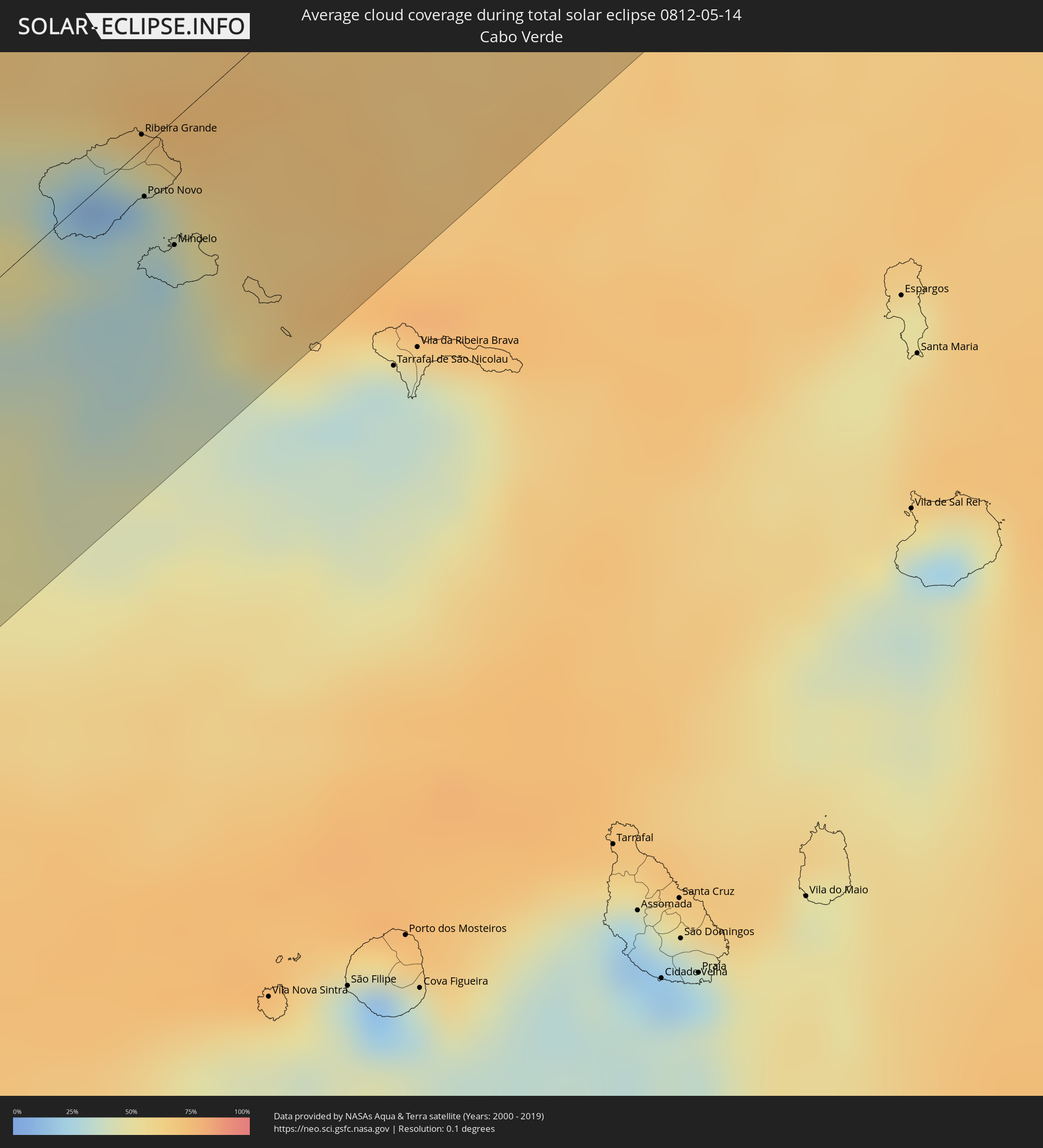 Cabo Verde
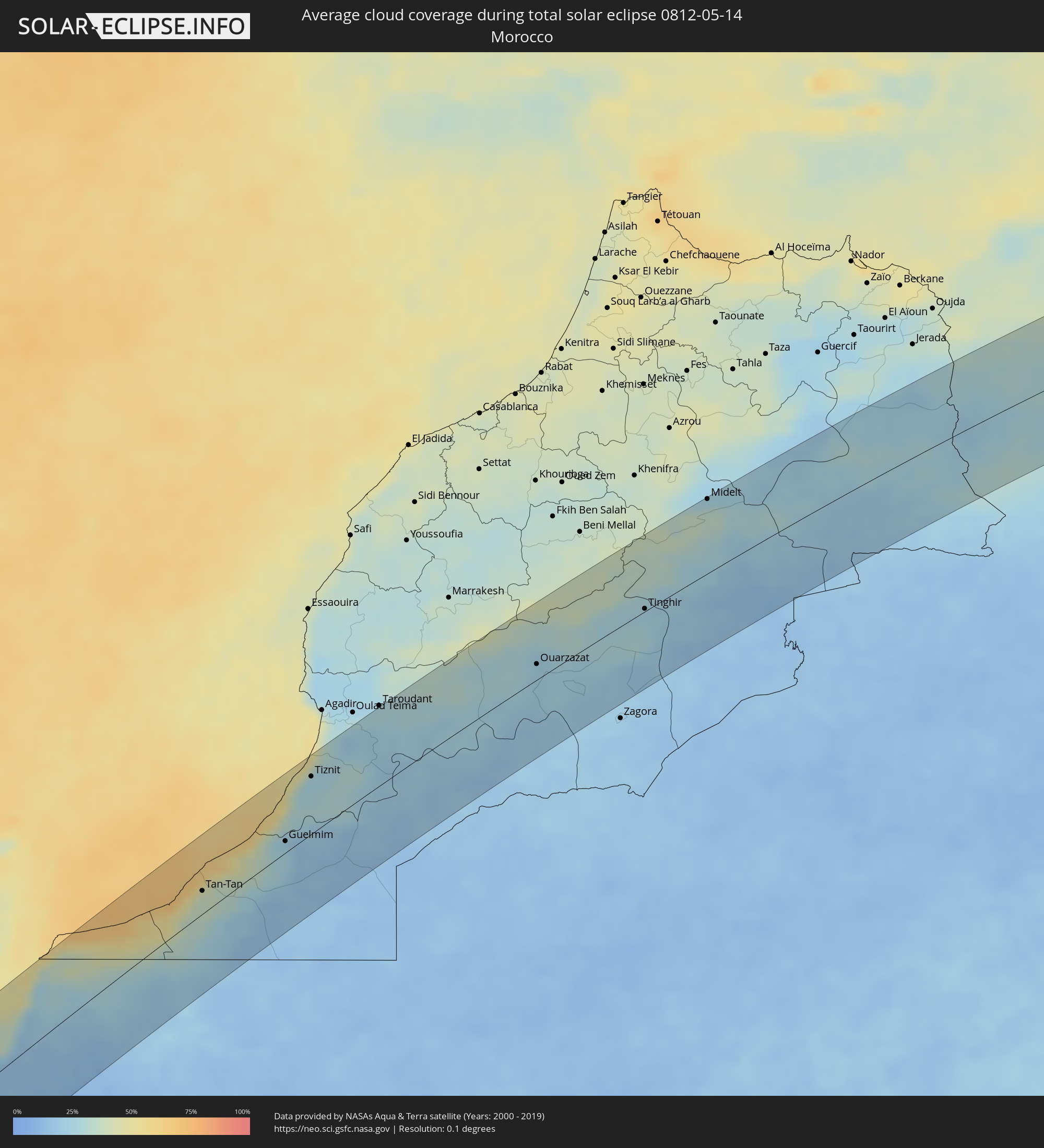 Morocco
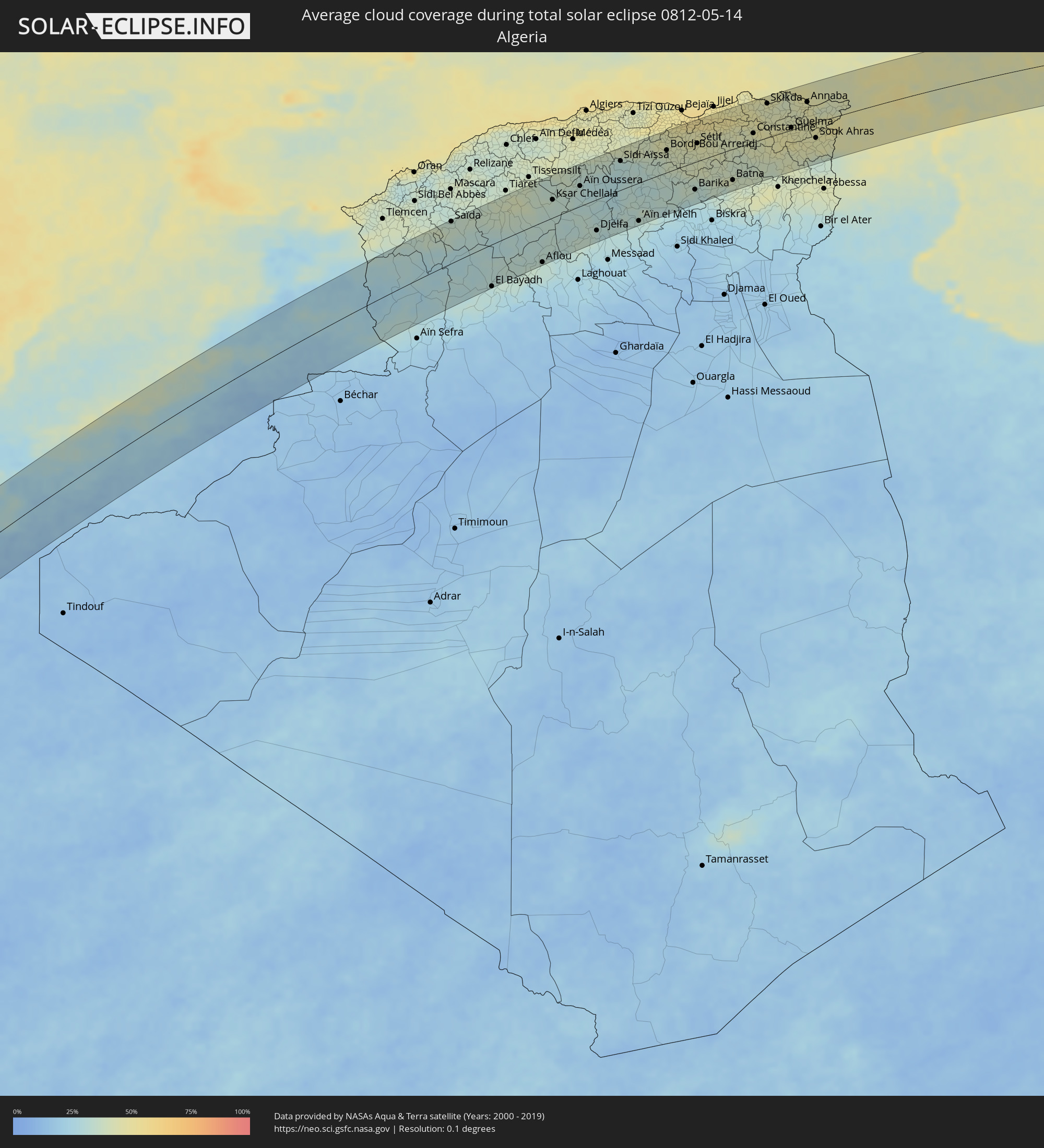 Algeria
 Italy
Italy
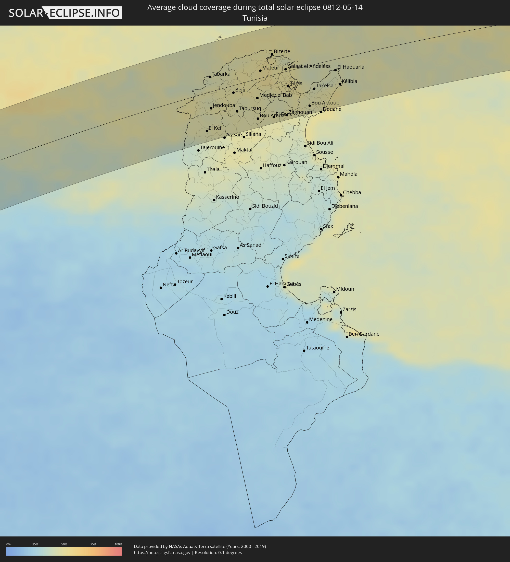 Tunisia
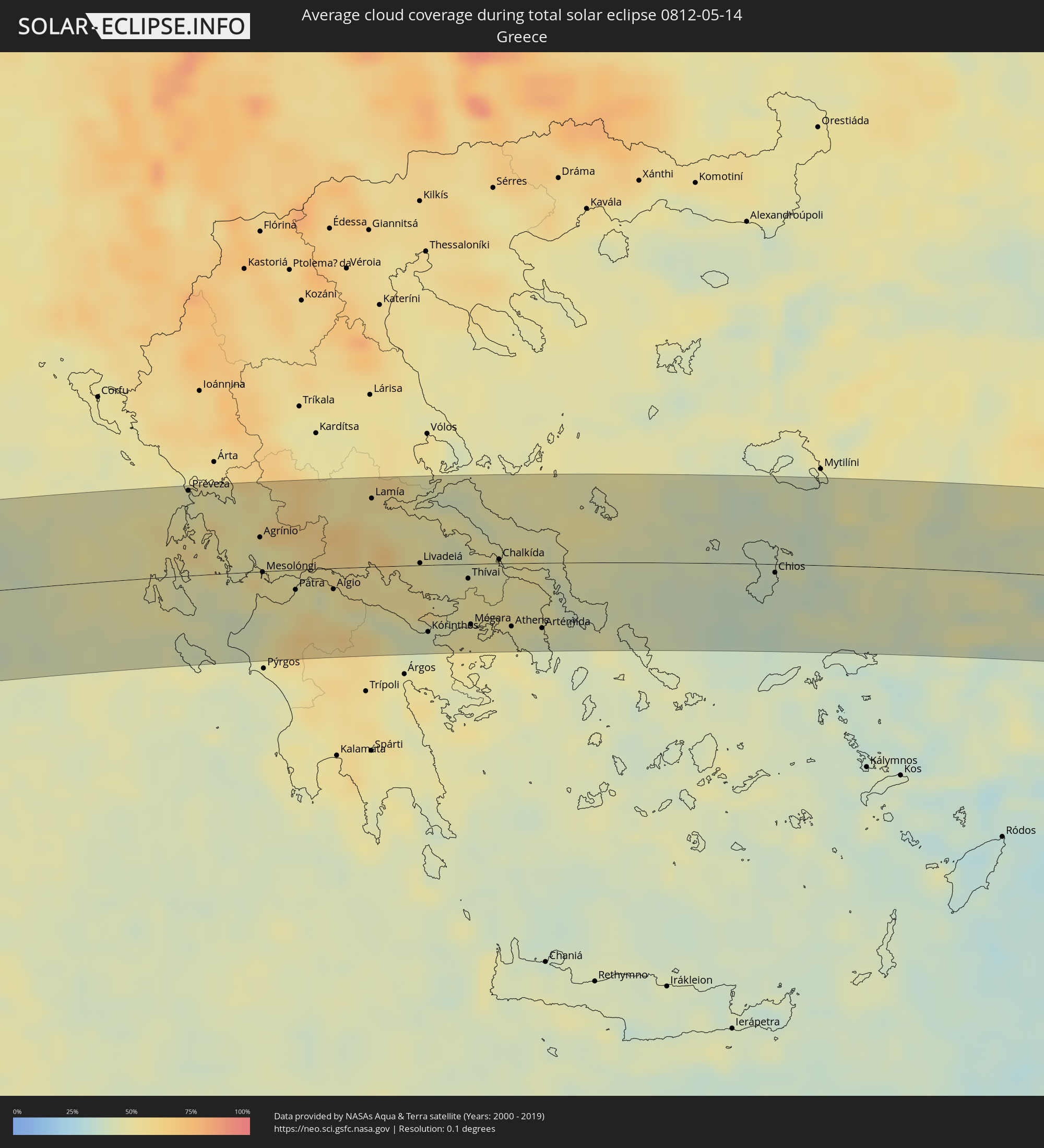 Greece
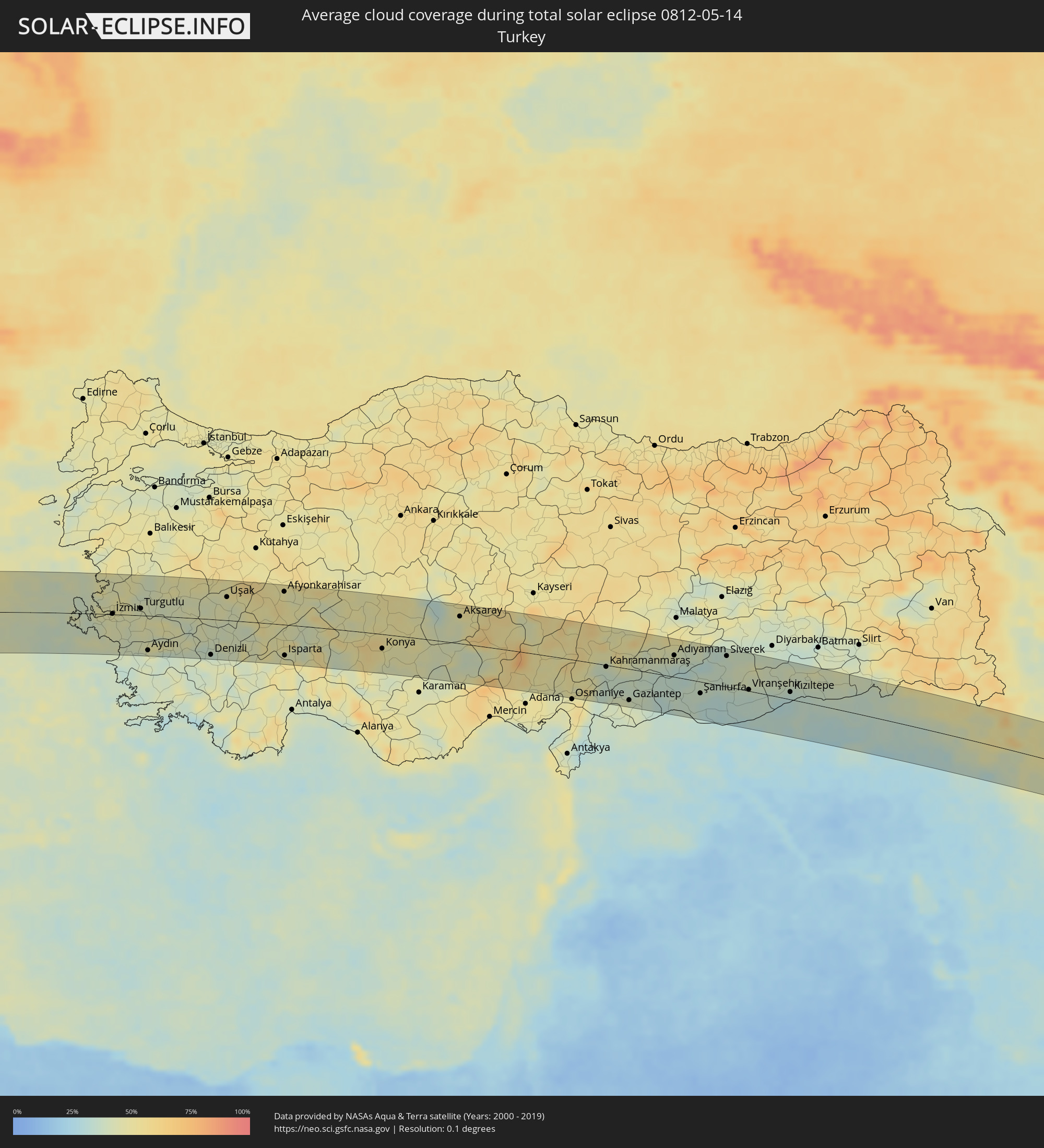 Turkey
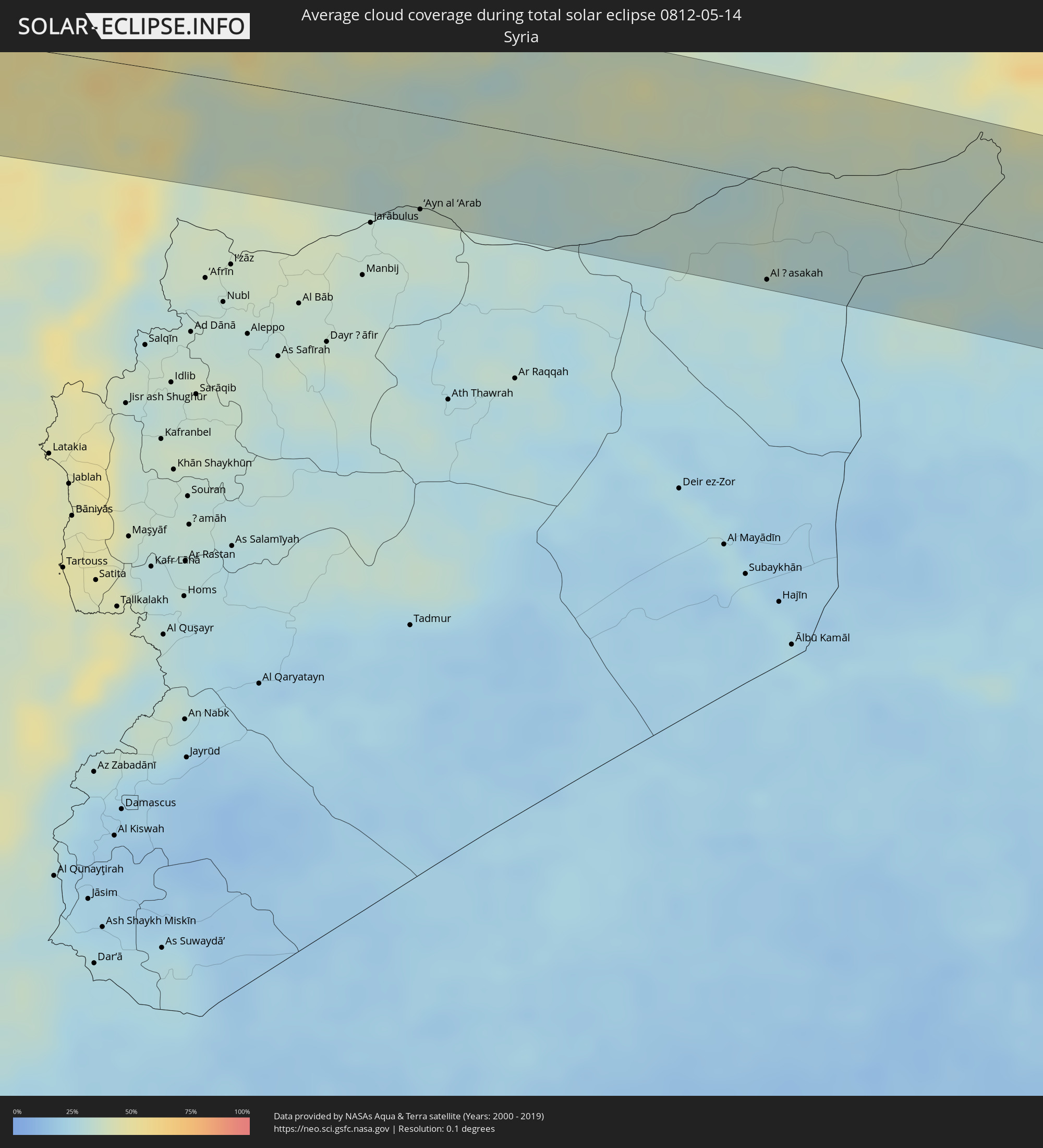 Syria
Syria
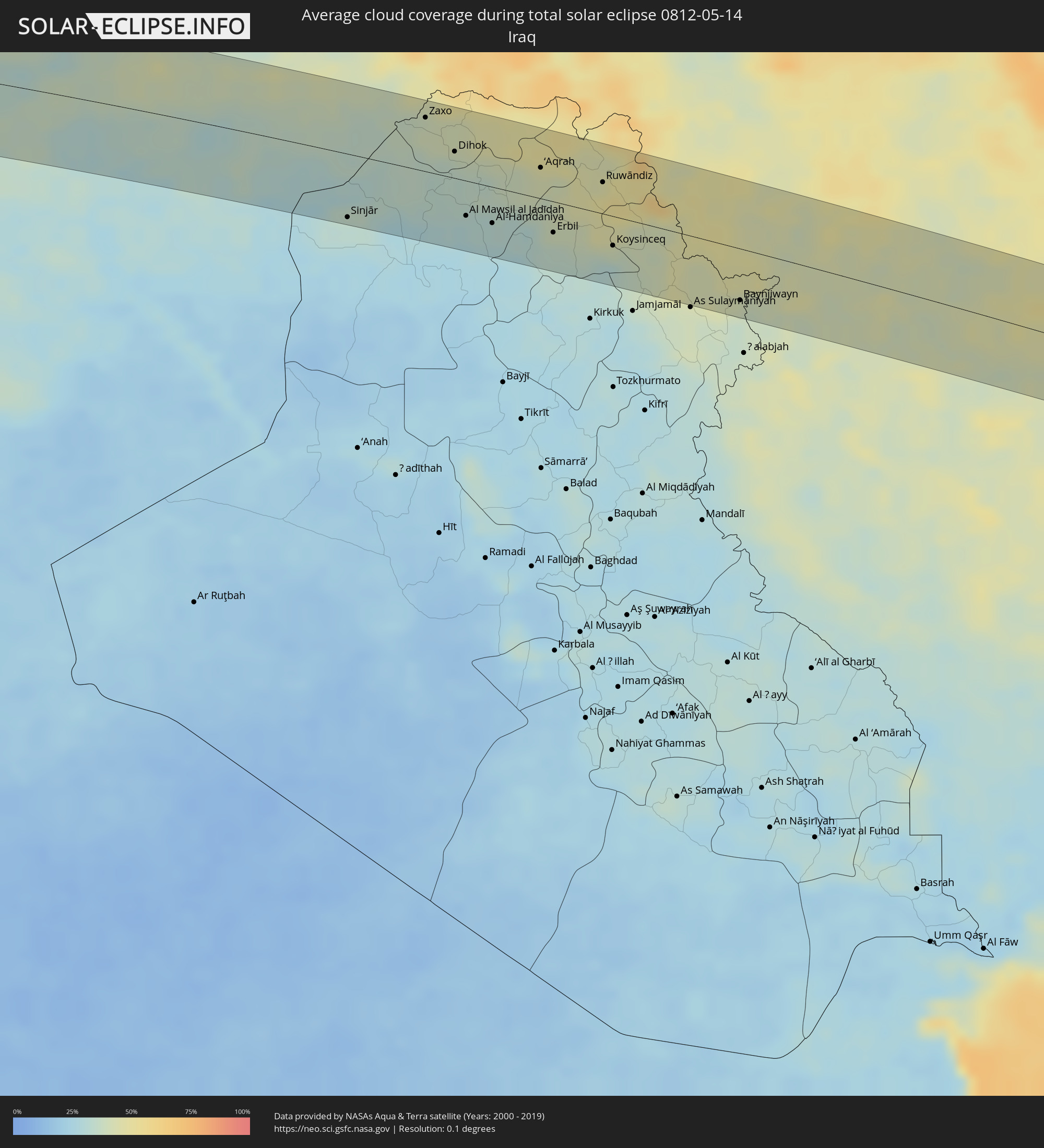 Iraq
Iraq
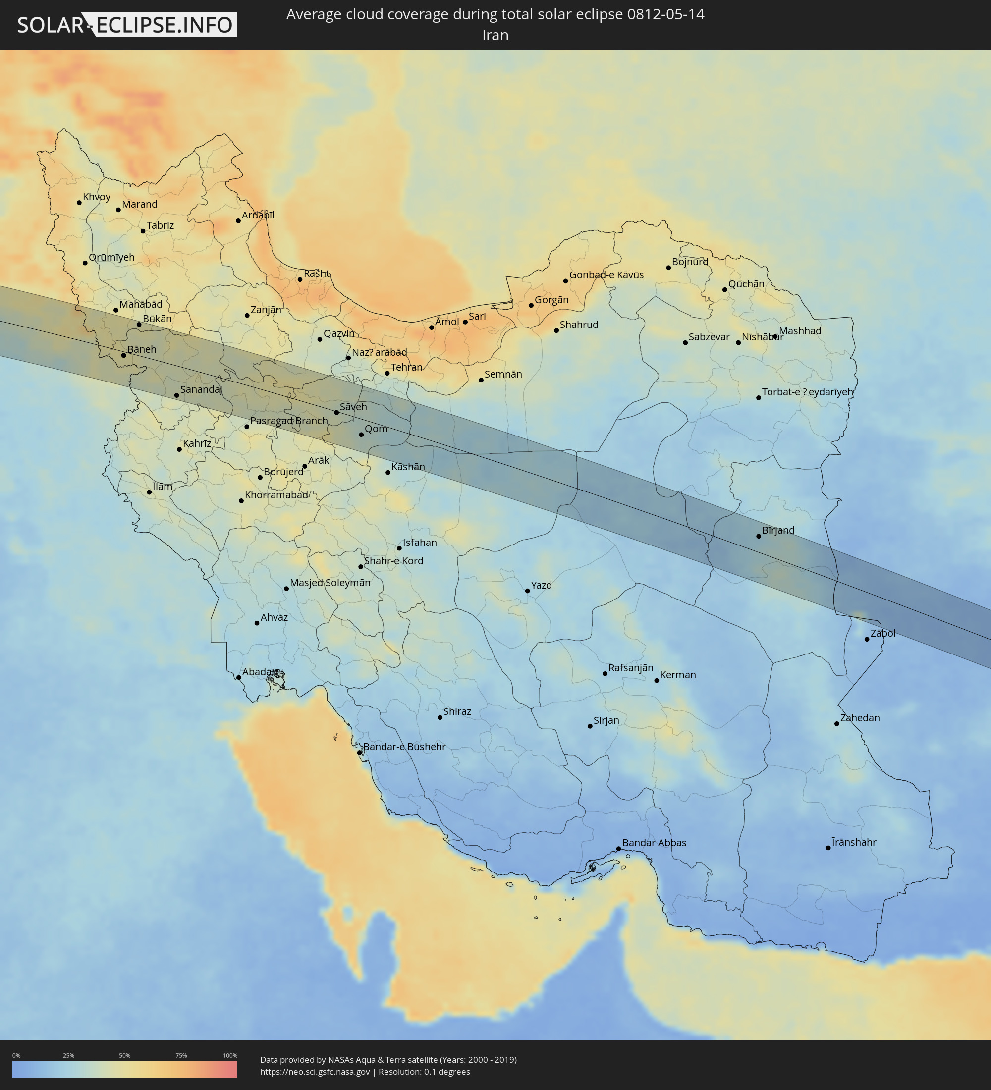 Iran
Iran
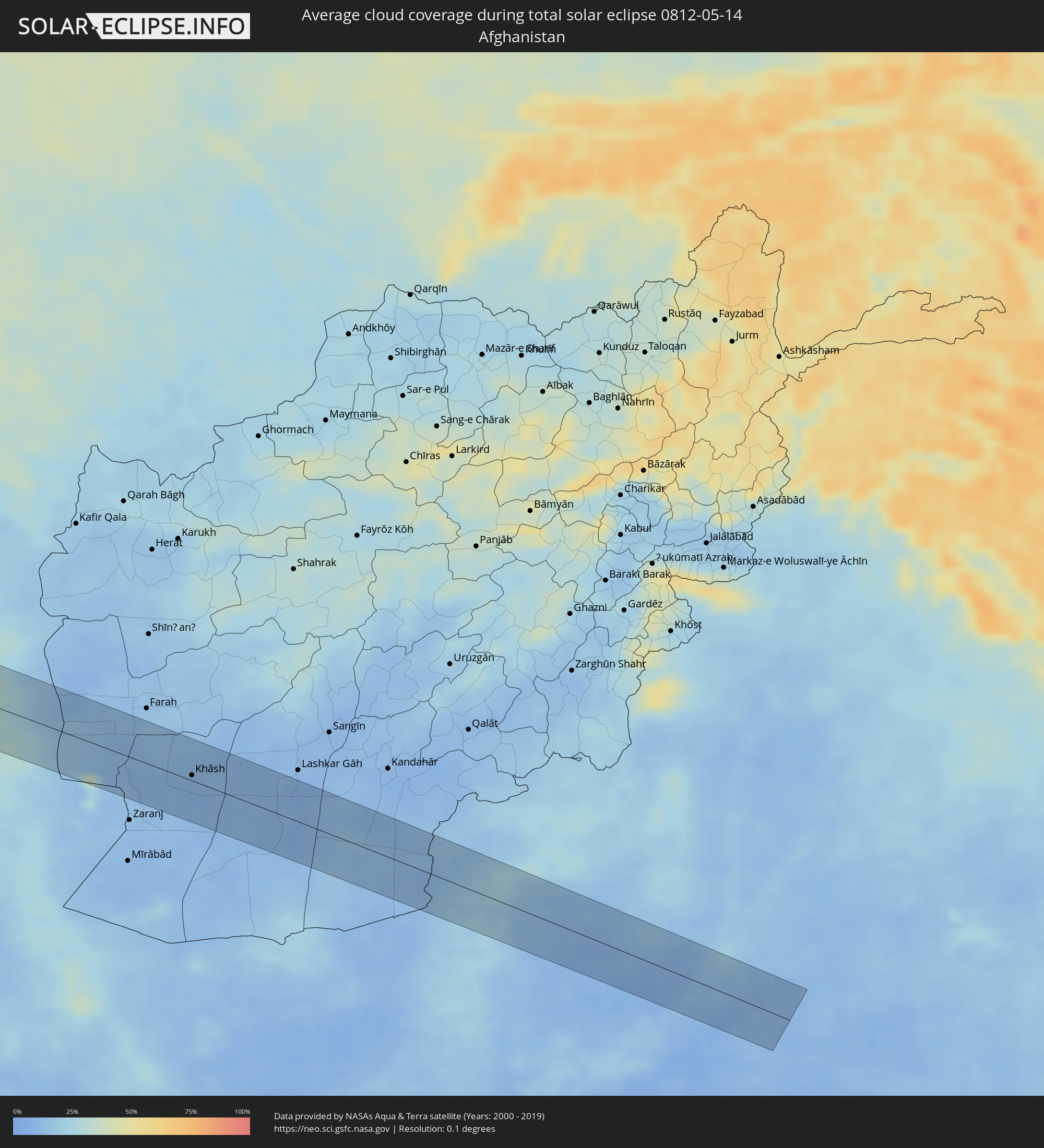 Afghanistan
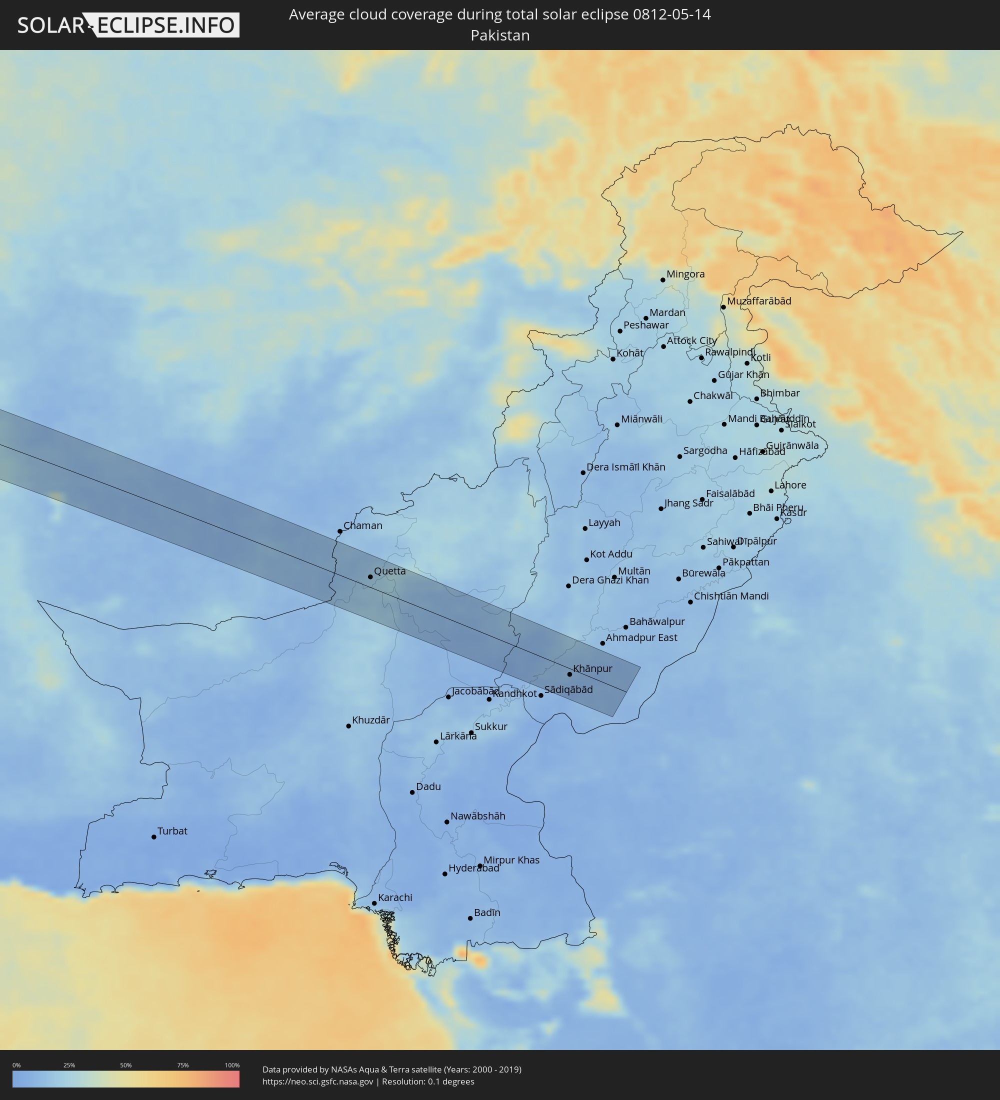 Pakistan
Cities inside the path of the eclipse
The following table shows all locations with a population of more than 5,000 inside the eclipse path. Cities which have more than 100,000 inhabitants are marked bold. A click at the locations opens a detailed map.
| City | Type | Eclipse duration | Local time of max. eclipse | Distance to central line | Ø Cloud coverage |
|
Manicoré, Amazonas
|
total | - | 06:21:33 UTC-04:02 | 33 km | 79% |
|
Itaituba, Pará
|
total | - | 07:11:06 UTC-03:13 | 42 km | 82% |
|
Porto de Moz, Pará
|
total | - | 07:13:28 UTC-03:13 | 31 km | 81% |
|
Gurupá, Pará
|
total | - | 07:13:52 UTC-03:13 | 34 km | 86% |
|
Portel, Pará
|
total | - | 07:13:33 UTC-03:13 | 60 km | 69% |
|
Breves, Pará
|
total | - | 07:13:50 UTC-03:13 | 53 km | 74% |
|
Soure, Pará
|
total | - | 07:15:11 UTC-03:13 | 62 km | 68% |
|
Ribeira Grande, Ribeira Grande
|
total | - | 09:38:47 UTC-01:34 | 3 km | 42% |
|
Porto Novo, Porto Novo
|
total | - | 09:38:30 UTC-01:34 | 11 km | 31% |
|
Pombas, Paul
|
total | - | 09:38:48 UTC-01:34 | 3 km | 58% |
|
Mindelo, São Vicente
|
total | - | 09:38:23 UTC-01:34 | 28 km | 27% |
 Laayoune Plage
|
total | - | 10:57:56 UTC-00:52 | 44 km | 27% |
|
Laâyoune / El Aaiún, Oued Ed-Dahab-Lagouira
|
total | - | 10:58:27 UTC-00:52 | 34 km | 21% |
|
Tan-Tan, Guelmim-Es Smara
|
total | - | 11:27:18 UTC-00:30 | 23 km | 36% |
|
Sidi Ifni, Souss-Massa-Drâa
|
total | - | 11:30:46 UTC-00:30 | 53 km | 54% |
|
Guelmim, Guelmim-Es Smara
|
total | - | 11:30:21 UTC-00:30 | 11 km | 24% |
|
Tiznit, Souss-Massa-Drâa
|
total | - | 11:32:11 UTC-00:30 | 57 km | 26% |
|
Ouarzazat, Souss-Massa-Drâa
|
total | - | 11:39:59 UTC-00:30 | 16 km | 22% |
|
Ifrane, Tadla-Azilal
|
total | - | 11:42:18 UTC-00:30 | 61 km | 36% |
|
Tinghir, Souss-Massa-Drâa
|
total | - | 11:43:45 UTC-00:30 | 3 km | 25% |
|
Midelt, Meknès-Tafilalet
|
total | - | 11:47:04 UTC-00:30 | 76 km | 31% |
|
Saïda, Saida
|
total | - | 12:39:41 UTC+00:09 | 74 km | 36% |
|
Aïn Oussera, Djelfa
|
total | - | 12:46:04 UTC+00:09 | 36 km | 32% |
|
Djelfa, Djelfa
|
total | - | 12:46:07 UTC+00:09 | 56 km | 31% |
|
M’Sila, M'Sila
|
total | - | 12:49:42 UTC+00:09 | 9 km | 34% |
|
Bordj Bou Arreridj, Bordj Bou Arréridj
|
total | - | 12:50:26 UTC+00:09 | 40 km | 40% |
|
Sétif, Sétif
|
total | - | 12:51:52 UTC+00:09 | 33 km | 43% |
|
El Eulma, Sétif
|
total | - | 12:52:24 UTC+00:09 | 20 km | 43% |
|
Batna, Batna
|
total | - | 12:52:59 UTC+00:09 | 57 km | 38% |
|
Constantine, Constantine
|
total | - | 12:54:27 UTC+00:09 | 16 km | 43% |
|
Skikda, Skikda
|
total | - | 12:55:22 UTC+00:09 | 62 km | 44% |
|
Oum el Bouaghi, Oum el Bouaghi
|
total | - | 12:55:09 UTC+00:09 | 50 km | 38% |
|
Aïn Beïda, Oum el Bouaghi
|
total | - | 12:55:41 UTC+00:09 | 66 km | 41% |
|
Guelma, Guelma
|
total | - | 12:56:09 UTC+00:09 | 4 km | 46% |
|
Annaba, Annaba
|
total | - | 12:57:06 UTC+00:09 | 42 km | 47% |
|
Souk Ahras, Souk Ahras
|
total | - | 12:57:07 UTC+00:09 | 28 km | 45% |
|
El Kef, Kef
|
total | - | 12:58:35 UTC+00:09 | 59 km | 44% |
|
Jendouba, Jundūbah
|
total | - | 12:58:55 UTC+00:09 | 26 km | 44% |
|
Béja, Bājah
|
total | - | 12:59:50 UTC+00:09 | 12 km | 46% |
|
Medjez el Bab, Bājah
|
total | - | 13:00:39 UTC+00:09 | 30 km | 46% |
|
Mateur, Banzart
|
total | - | 13:00:56 UTC+00:09 | 11 km | 52% |
|
Menzel Bourguiba, Banzart
|
total | - | 13:01:14 UTC+00:09 | 20 km | 52% |
|
Bizerte, Banzart
|
total | - | 13:01:27 UTC+00:09 | 31 km | 49% |
|
La Mohammedia, Tūnis
|
total | - | 13:01:45 UTC+00:09 | 40 km | 46% |
|
Tunis, Tūnis
|
total | - | 13:01:50 UTC+00:09 | 24 km | 47% |
|
Al Marsá, Tūnis
|
total | - | 13:02:10 UTC+00:09 | 21 km | 51% |
|
Hammam-Lif, Tūnis
|
total | - | 13:02:08 UTC+00:09 | 38 km | 48% |
|
Takelsa, Nābul
|
total | - | 13:02:44 UTC+00:09 | 38 km | 44% |
|
Dar Chabanne, Nābul
|
total | - | 13:02:51 UTC+00:09 | 75 km | 51% |
|
Korba, Nābul
|
total | - | 13:03:06 UTC+00:09 | 65 km | 52% |
|
Kélibia, Nābul
|
total | - | 13:03:40 UTC+00:09 | 41 km | 50% |
|
Marsala, Sicily
|
total | - | 13:57:13 UTC+01:00 | 36 km | 46% |
|
Trapani, Sicily
|
total | - | 13:57:27 UTC+01:00 | 59 km | 44% |
|
Mazara del Vallo, Sicily
|
total | - | 13:57:28 UTC+01:00 | 18 km | 49% |
|
Alcamo, Sicily
|
total | - | 13:58:15 UTC+01:00 | 47 km | 43% |
|
Sciacca, Sicily
|
total | - | 13:58:21 UTC+01:00 | 7 km | 47% |
|
Palermo, Sicily
|
total | - | 13:58:58 UTC+01:00 | 57 km | 49% |
|
Bagheria, Sicily
|
total | - | 13:59:17 UTC+01:00 | 49 km | 43% |
|
Licata, Sicily
|
total | - | 13:59:53 UTC+01:00 | 65 km | 43% |
|
Caltanissetta, Sicily
|
total | - | 14:00:11 UTC+01:00 | 25 km | 48% |
|
Gela, Sicily
|
total | - | 14:00:26 UTC+01:00 | 73 km | 48% |
|
Caltagirone, Sicily
|
total | - | 14:00:59 UTC+01:00 | 59 km | 48% |
|
Paternò, Sicily
|
total | - | 14:01:45 UTC+01:00 | 29 km | 45% |
|
Catania, Sicily
|
total | - | 14:02:03 UTC+01:00 | 39 km | 49% |
|
Acireale, Sicily
|
total | - | 14:02:14 UTC+01:00 | 28 km | 50% |
|
Messina, Sicily
|
total | - | 14:03:00 UTC+01:00 | 31 km | 62% |
|
Préveza, Epirus
|
total | - | 14:46:38 UTC+01:34 | 68 km | 45% |
|
Agrínio, West Greece
|
total | - | 14:47:45 UTC+01:34 | 27 km | 46% |
|
Pátra, West Greece
|
total | - | 14:48:20 UTC+01:34 | 16 km | 49% |
|
Aígio, West Greece
|
total | - | 14:48:53 UTC+01:34 | 17 km | 50% |
|
Lamía, Central Greece
|
total | - | 14:49:17 UTC+01:34 | 54 km | 53% |
|
Livadeiá, Central Greece
|
total | - | 14:50:05 UTC+01:34 | 2 km | 52% |
|
Kórinthos, Peloponnese
|
total | - | 14:50:19 UTC+01:34 | 54 km | 43% |
|
Thívai, Central Greece
|
total | - | 14:50:47 UTC+01:34 | 12 km | 49% |
|
Salamína, Attica
|
total | - | 14:51:10 UTC+01:34 | 52 km | 50% |
|
Chalkída, Central Greece
|
total | - | 14:51:11 UTC+01:34 | 3 km | 45% |
|
Athens, Attica
|
total | - | 14:51:30 UTC+01:34 | 51 km | 46% |
|
Voúla, Attica
|
total | - | 14:51:37 UTC+01:34 | 66 km | 53% |
|
Néa Erythraía, Attica
|
total | - | 14:51:37 UTC+01:34 | 38 km | 49% |
|
Artémida, Attica
|
total | - | 14:51:55 UTC+01:34 | 52 km | 43% |
|
Chios, North Aegean
|
total | - | 14:54:55 UTC+01:34 | 7 km | 37% |
|
İzmir, İzmir
|
total | - | 15:18:22 UTC+01:56 | 1 km | 45% |
|
Manisa, Manisa
|
total | - | 15:18:40 UTC+01:56 | 24 km | 47% |
|
Aydın, Aydın
|
total | - | 15:19:34 UTC+01:56 | 60 km | 38% |
|
Denizli, Denizli
|
total | - | 15:21:17 UTC+01:56 | 62 km | 40% |
|
Uşak, Uşak
|
total | - | 15:21:15 UTC+01:56 | 40 km | 45% |
|
Isparta, Isparta
|
total | - | 15:23:10 UTC+01:56 | 53 km | 49% |
|
Konya, Konya
|
total | - | 15:25:26 UTC+01:56 | 25 km | 49% |
|
Aksaray, Aksaray
|
total | - | 15:26:52 UTC+01:56 | 47 km | 44% |
|
Kahramanmaraş, Kahramanmaraş
|
total | - | 15:30:24 UTC+01:56 | 3 km | 36% |
|
Gaziantep, Gaziantep
|
total | - | 15:31:11 UTC+01:56 | 54 km | 41% |
|
Adıyaman, Adıyaman
|
total | - | 15:31:33 UTC+01:56 | 37 km | 37% |
|
‘Ayn al ‘Arab, Aleppo
|
total | - | 16:00:30 UTC+02:25 | 57 km | 33% |
|
Şanlıurfa, Şanlıurfa
|
total | - | 15:32:27 UTC+01:56 | 20 km | 36% |
|
Siverek, Şanlıurfa
|
total | - | 15:32:30 UTC+01:56 | 53 km | 37% |
|
Viranşehir, Şanlıurfa
|
total | - | 15:33:16 UTC+01:56 | 2 km | 32% |
|
Kızıltepe, Mardin
|
total | - | 15:34:00 UTC+01:56 | 13 km | 31% |
|
Ad Darbāsīyah, Al-Hasakah
|
total | - | 16:02:24 UTC+02:25 | 2 km | 33% |
|
Al Ḩasakah, Al-Hasakah
|
total | - | 16:02:54 UTC+02:25 | 59 km | 28% |
|
Sinjār, Nīnawá
|
total | - | 16:36:21 UTC+02:57 | 57 km | 32% |
|
Zaxo, Dahūk
|
total | - | 16:36:22 UTC+02:57 | 48 km | 40% |
|
Dihok, Dahūk
|
total | - | 16:36:48 UTC+02:57 | 24 km | 38% |
|
Sīnah, Dahūk
|
total | - | 16:36:53 UTC+02:57 | 18 km | 35% |
|
Al Mawşil al Jadīdah, Nīnawá
|
total | - | 16:37:17 UTC+02:57 | 32 km | 30% |
|
Mosul, Nīnawá
|
total | - | 16:37:17 UTC+02:57 | 31 km | 30% |
|
Tallkayf, Nīnawá
|
total | - | 16:37:11 UTC+02:57 | 14 km | 32% |
|
Al-Hamdaniya, Nīnawá
|
total | - | 16:37:32 UTC+02:57 | 33 km | 32% |
|
‘Aqrah, Nīnawá
|
total | - | 16:37:33 UTC+02:57 | 28 km | 43% |
|
Erbil, Arbīl
|
total | - | 16:38:03 UTC+02:57 | 28 km | 35% |
|
Ruwāndiz, Arbīl
|
total | - | 16:38:05 UTC+02:57 | 28 km | 50% |
|
Koysinceq, Arbīl
|
total | - | 16:38:33 UTC+02:57 | 27 km | 38% |
|
Piranshahr, Āz̄ārbāyjān-e Gharbī
|
total | - | 17:06:34 UTC+03:25 | 51 km | 48% |
|
Bāneh, Kordestān
|
total | - | 17:07:35 UTC+03:25 | 8 km | 47% |
|
Baynjiwayn, As Sulaymānīyah
|
total | - | 16:39:46 UTC+02:57 | 47 km | 39% |
|
Būkān, Āz̄ārbāyjān-e Gharbī
|
total | - | 17:07:23 UTC+03:25 | 56 km | 48% |
|
Saqqez, Kordestān
|
total | - | 17:07:38 UTC+03:25 | 28 km | 42% |
|
Sanandaj, Kordestān
|
total | - | 17:08:47 UTC+03:25 | 55 km | 42% |
|
Bījār, Kordestān
|
total | - | 17:08:43 UTC+03:25 | 18 km | 43% |
|
Qorveh, Kordestān
|
total | - | 17:09:22 UTC+03:25 | 52 km | 42% |
|
Tafresh, Markazi
|
total | - | 17:10:53 UTC+03:25 | 47 km | 50% |
|
Sāveh, Markazi
|
total | - | 17:10:48 UTC+03:25 | 3 km | 40% |
|
Qom, Qom
|
total | - | 17:11:19 UTC+03:25 | 30 km | 34% |
|
Eqbālīyeh, Tehrān
|
total | - | 17:11:06 UTC+03:25 | 59 km | 33% |
|
Tabas, Yazd
|
total | - | 17:14:11 UTC+03:25 | 34 km | 21% |
|
Bīrjand, Khorāsān-e Jonūbī
|
total | - | 17:15:11 UTC+03:25 | 29 km | 24% |
|
Khāsh, Nimroz
|
total | - | 17:50:46 UTC+04:00 | 7 km | 9% |
|
Markaz-e Ḩukūmat-e Darwēshān, Helmand
|
total | - | 17:51:05 UTC+04:00 | 14 km | 11% |
|
Mastung, Balochistān
|
total | - | 18:20:03 UTC+04:28 | 31 km | 20% |
|
Kot Malik Barkhurdār, Balochistān
|
total | - | 18:19:47 UTC+04:28 | 16 km | 19% |
|
Quetta, Balochistān
|
total | - | 18:19:47 UTC+04:28 | 16 km | 19% |
|
Mach, Balochistān
|
total | - | 18:19:58 UTC+04:28 | 7 km | 16% |
|
Dādhar, Balochistān
|
total | - | 18:20:11 UTC+04:28 | 35 km | 12% |
|
Sibi, Balochistān
|
total | - | 18:20:07 UTC+04:28 | 20 km | 11% |
|
Harnai, Balochistān
|
total | - | 18:19:46 UTC+04:28 | 40 km | 12% |
|
Dera Bugti, Balochistān
|
total | - | 18:20:16 UTC+04:28 | 26 km | 8% |
|
Rojhān, Punjab
|
total | - | 18:20:21 UTC+04:28 | 32 km | 10% |
|
Rājanpur, Punjab
|
total | - | 18:20:03 UTC+04:28 | 24 km | 12% |
|
Kot Samāba, Punjab
|
total | - | 18:20:21 UTC+04:28 | 27 km | 8% |
|
Zāhir Pīr, Punjab
|
total | - | 18:20:11 UTC+04:28 | 2 km | 11% |
|
Khānpur, Punjab
|
total | - | 18:20:16 UTC+04:28 | 10 km | 9% |