Totale Sonnenfinsternis vom 29.10.0878
| Wochentag: | Samstag |
| Maximale Dauer der Verfinsterung: | 01m50s |
| Maximale Breite des Finsternispfades: | 250 km |
| Saroszyklus: | 115 |
| Bedeckungsgrad: | 100% |
| Magnitude: | 1.0246 |
| Gamma: | 0.9411 |
Wo kann man die Sonnenfinsternis vom 29.10.0878 sehen?
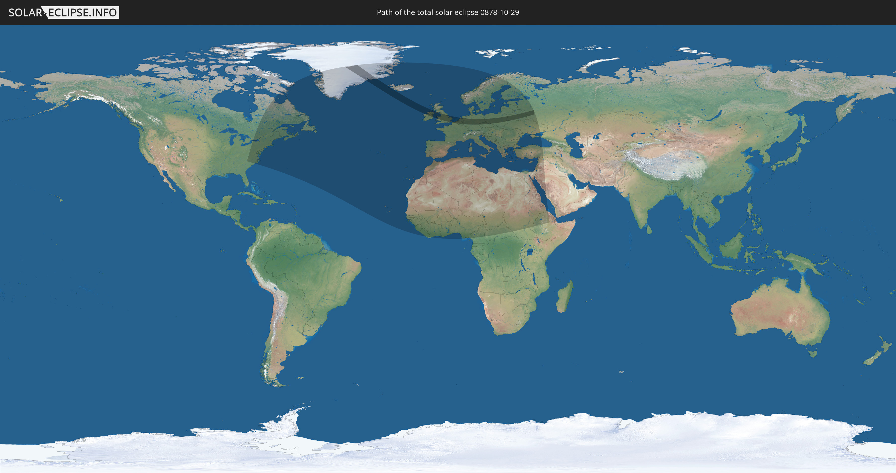
Die Sonnenfinsternis am 29.10.0878 kann man in 91 Ländern als partielle Sonnenfinsternis beobachten.
Der Finsternispfad verläuft durch 14 Länder. Nur in diesen Ländern ist sie als totale Sonnenfinsternis zu sehen.
In den folgenden Ländern ist die Sonnenfinsternis total zu sehen
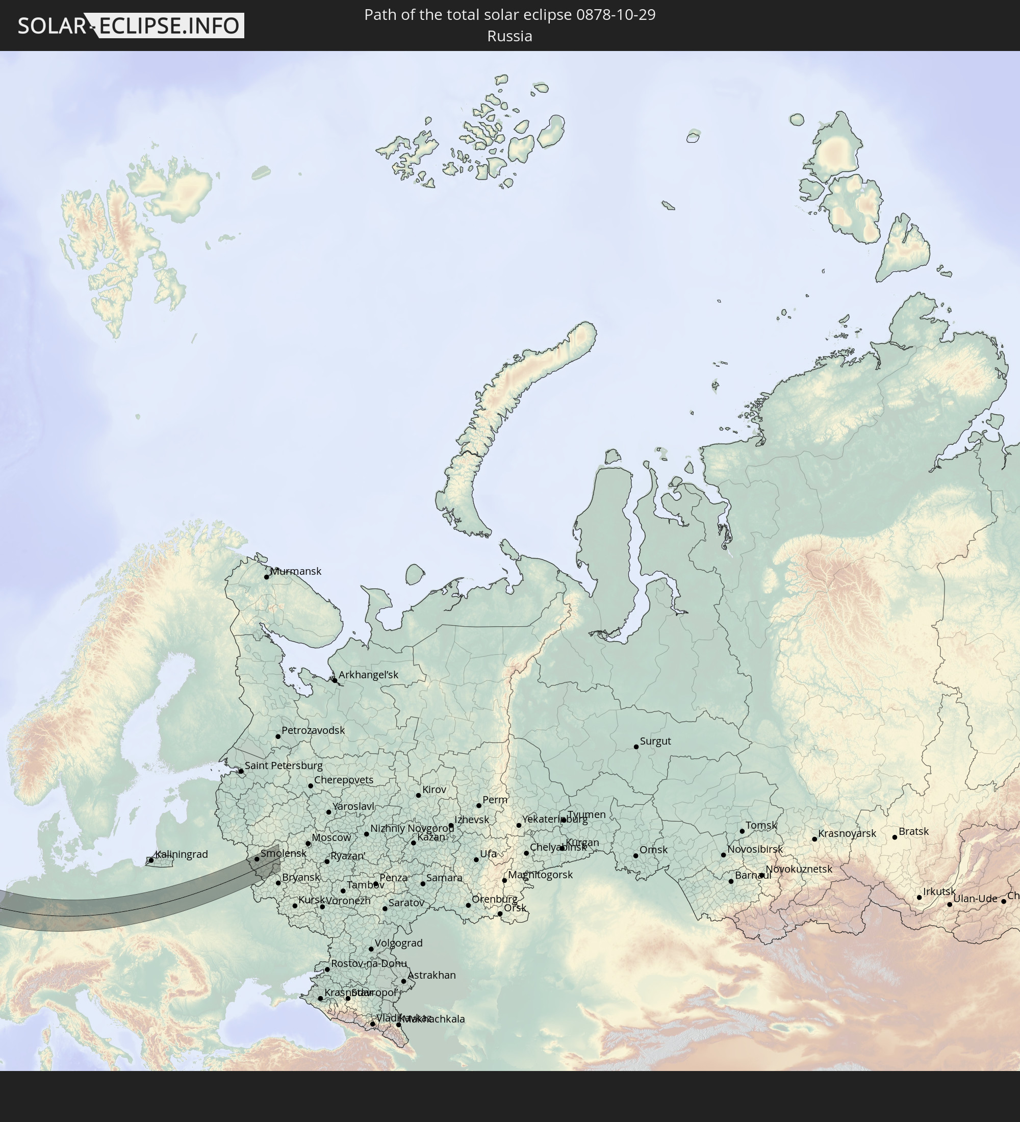 Russland
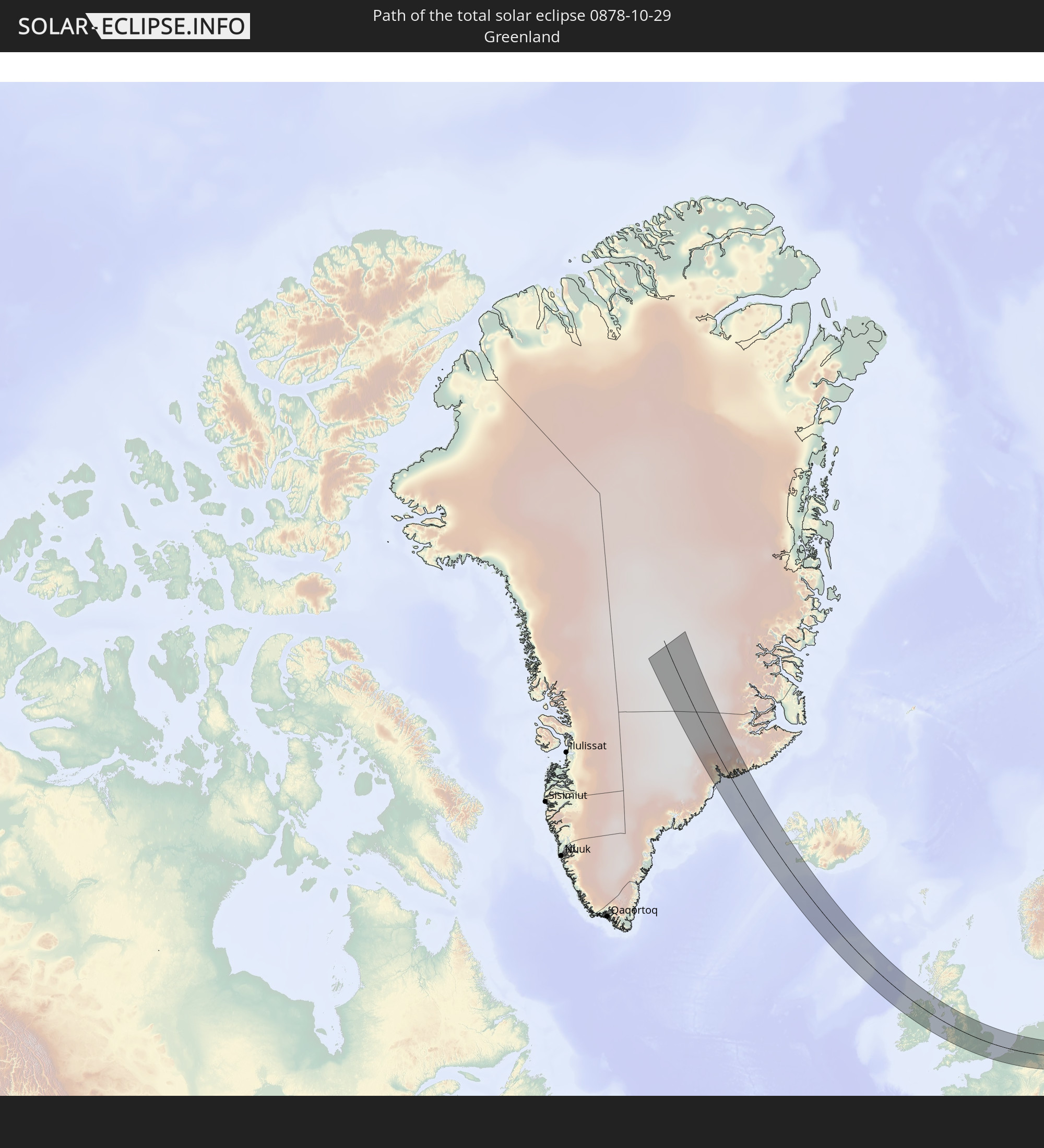 Grönland
 Island
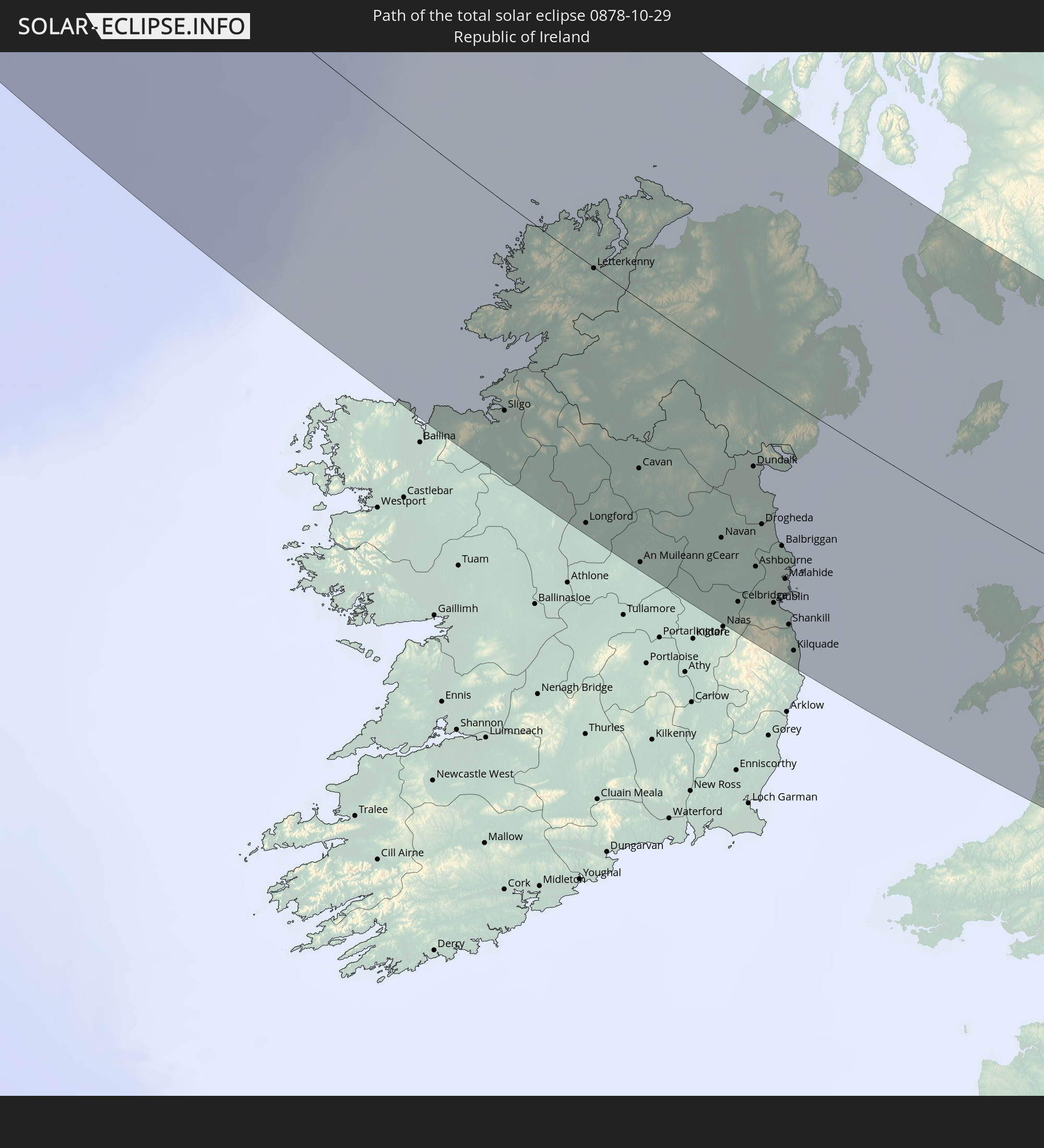 Irland
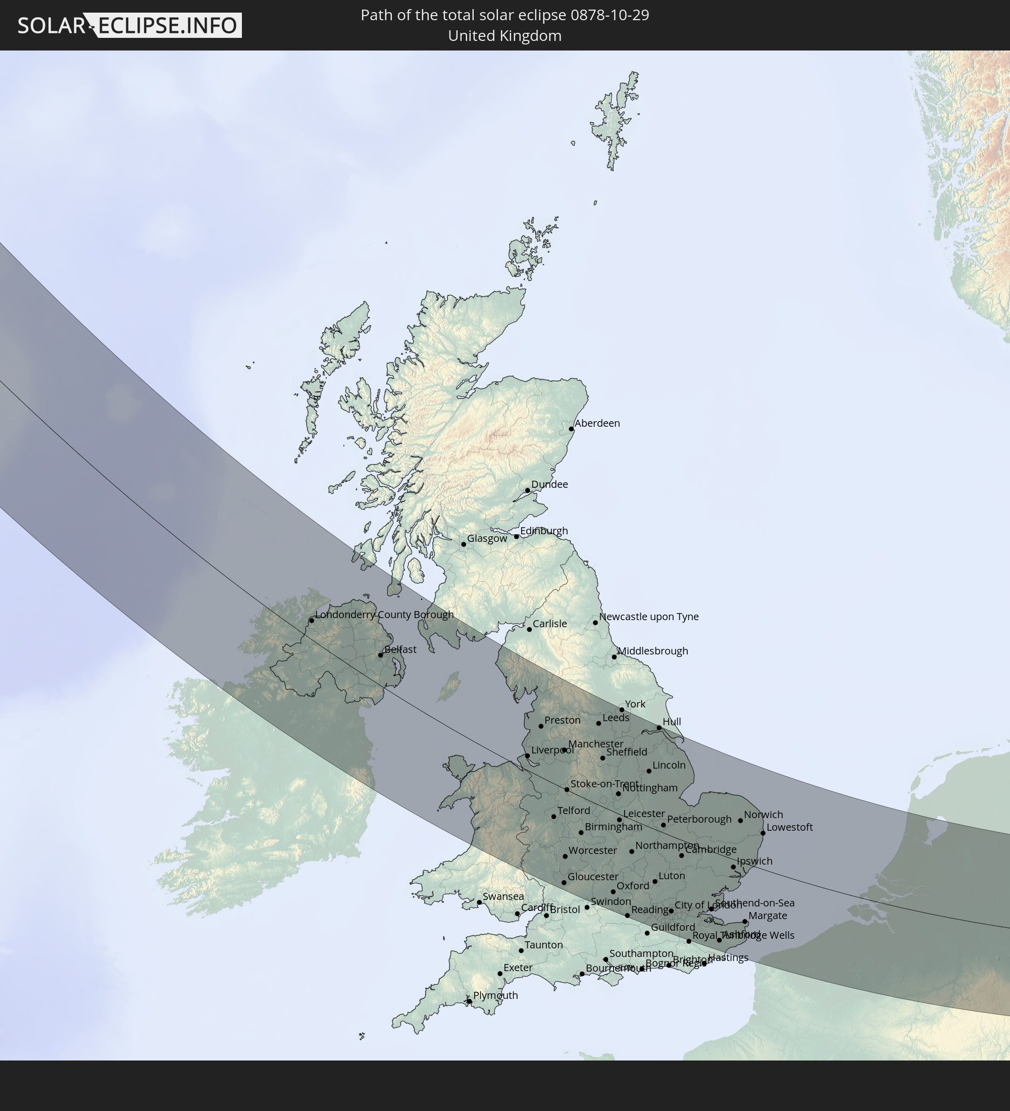 Vereinigtes Königreich
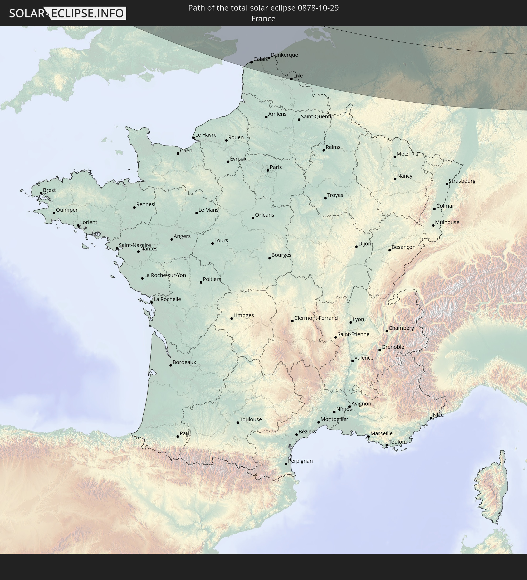 Frankreich
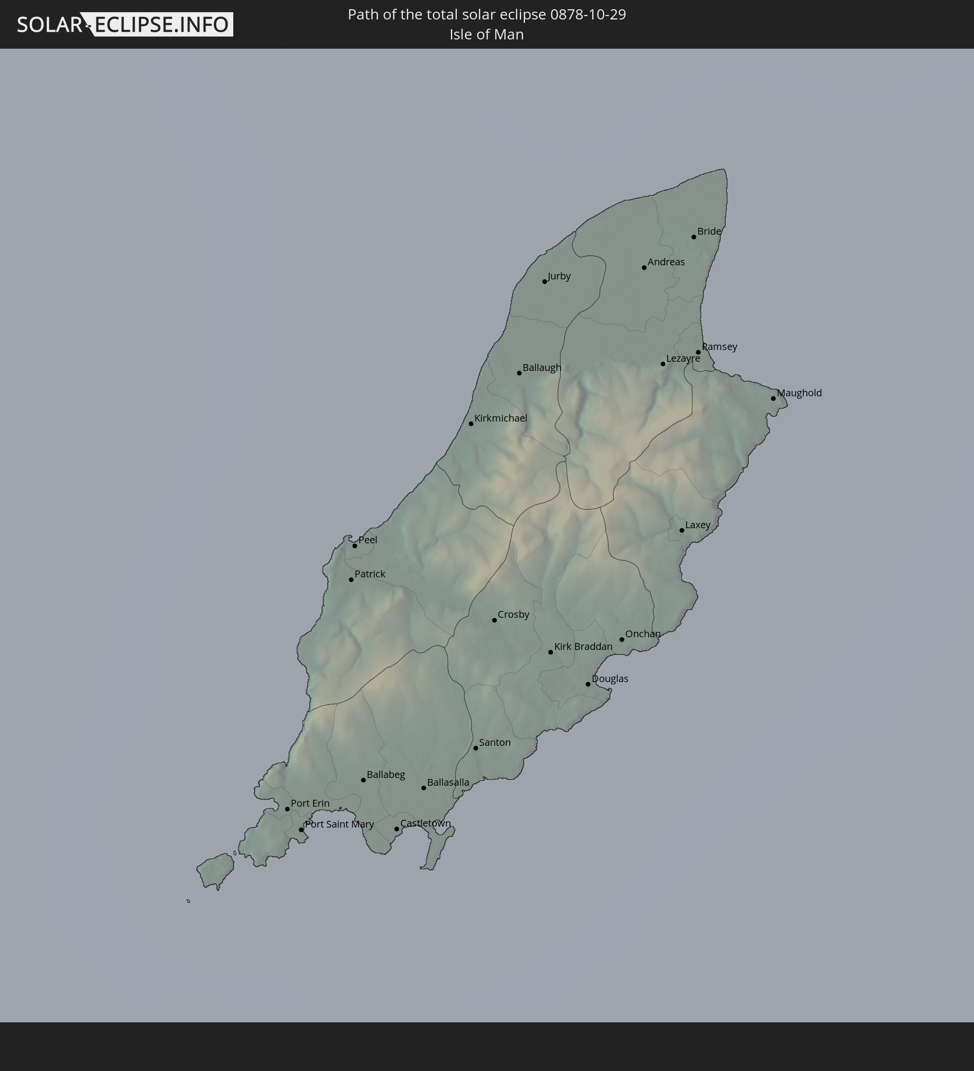 Isle of Man
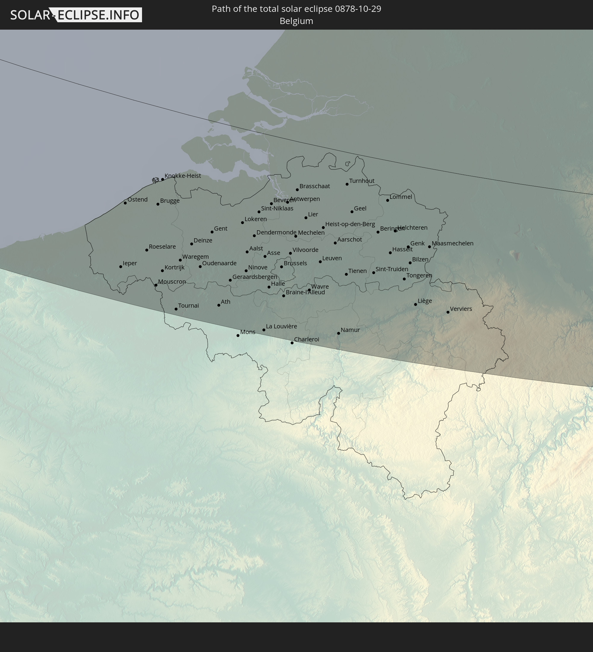 Belgien
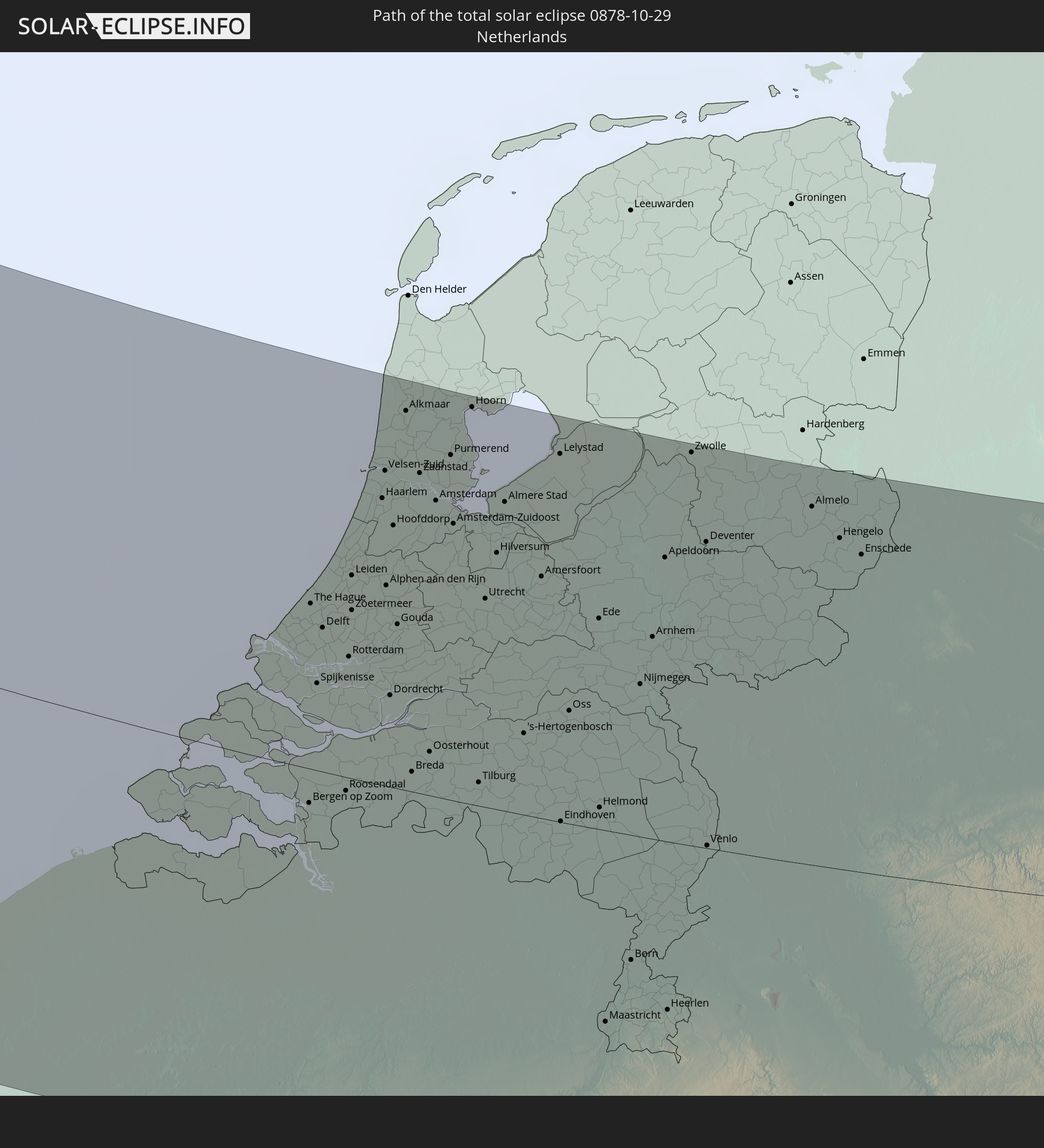 Niederlande
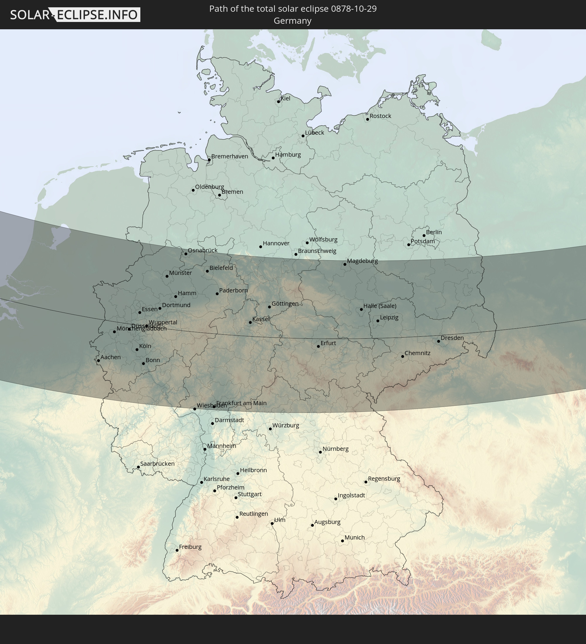 Deutschland
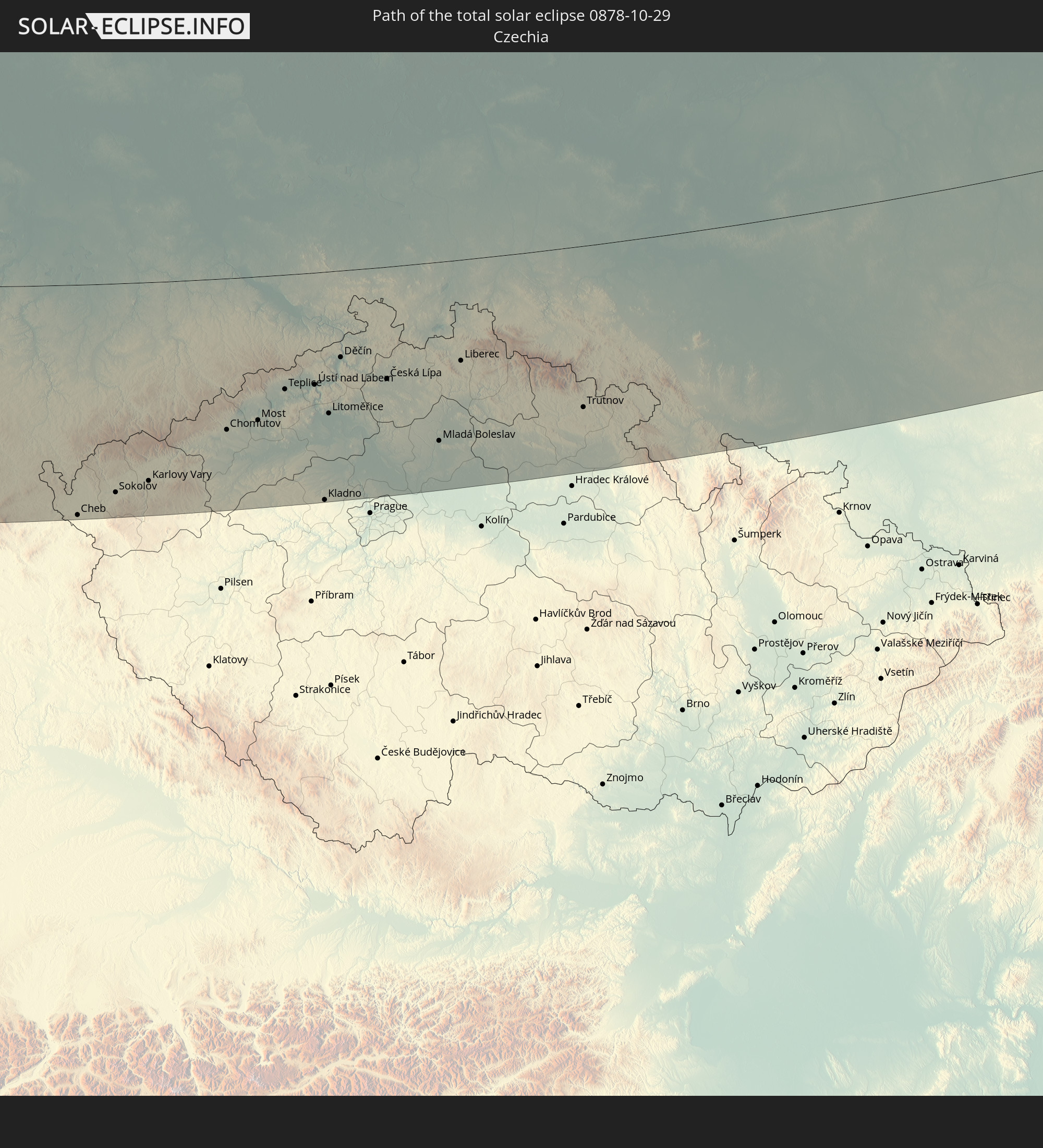 Tschechien
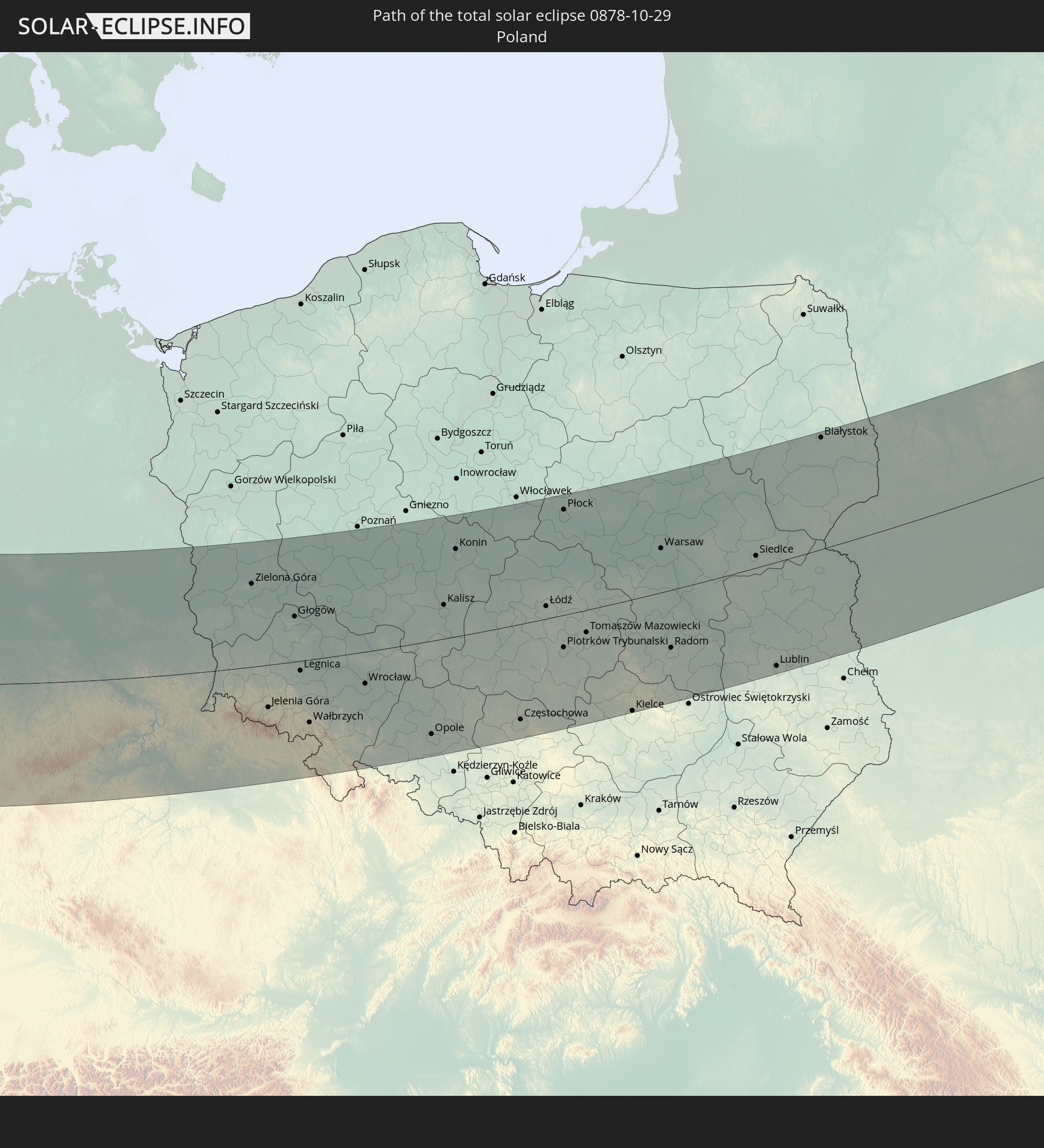 Polen
Polen
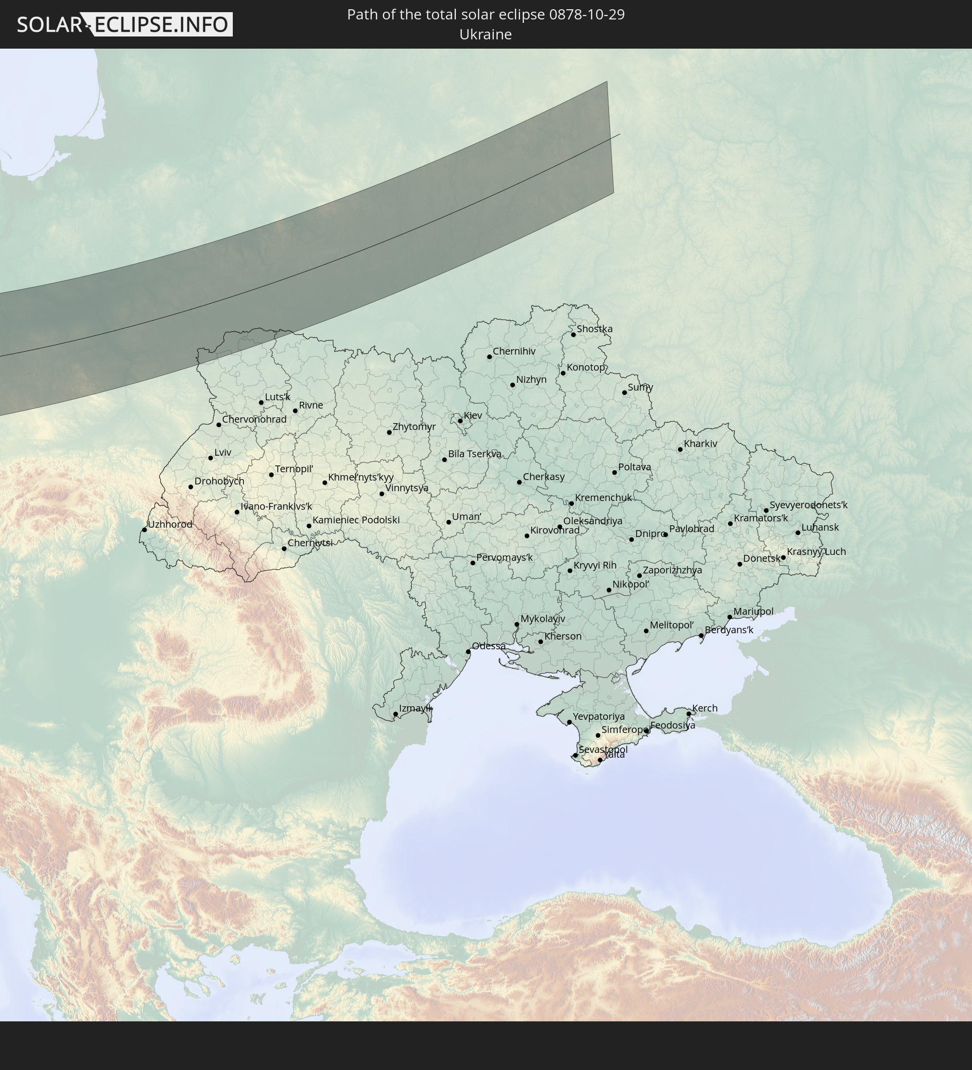 Ukraine
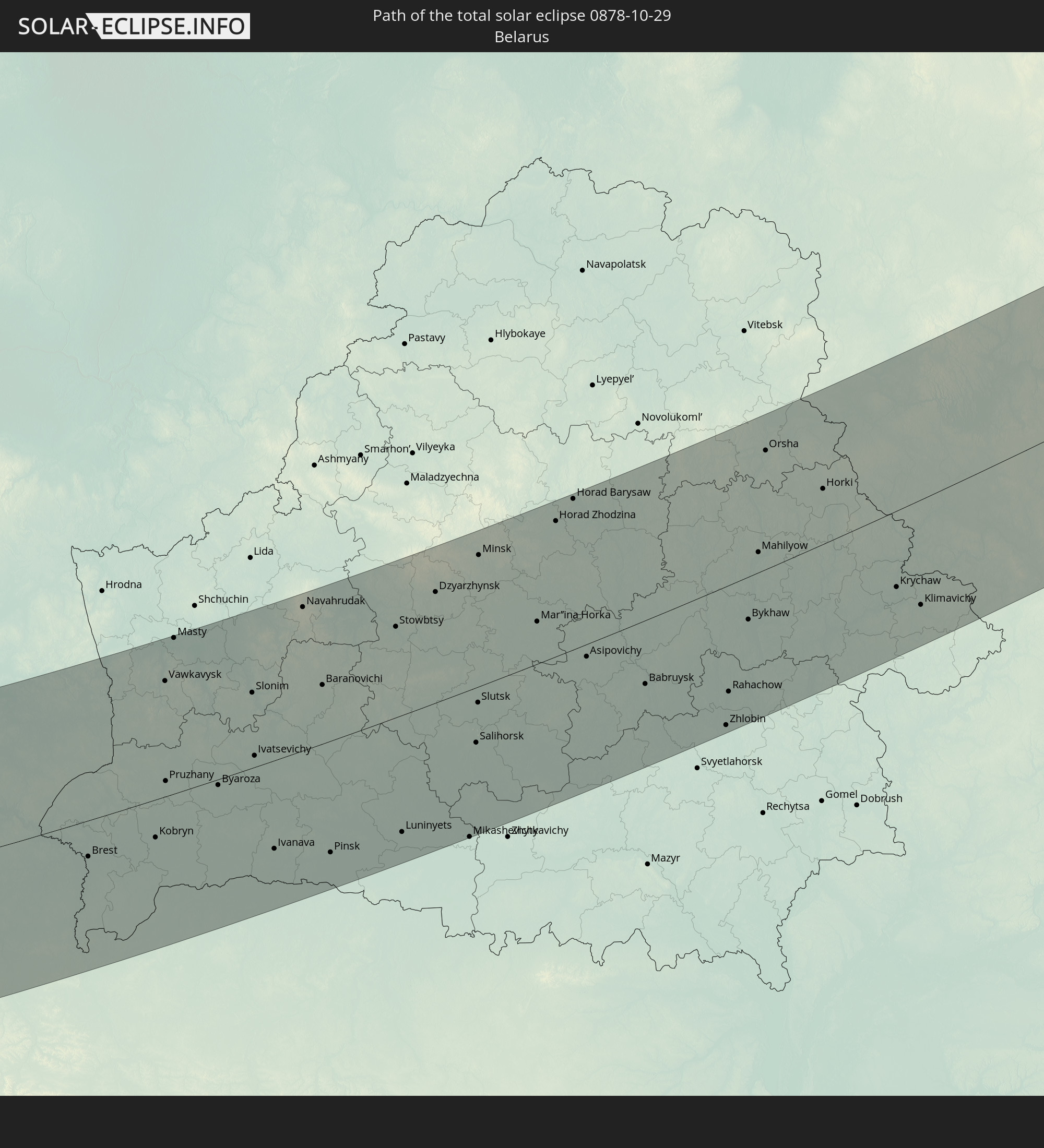 Weißrussland
In den folgenden Ländern ist die Sonnenfinsternis partiell zu sehen
 Russland
 Vereinigte Staaten
 Kanada
 Grönland
 Bermuda
 Saint-Pierre und Miquelon
 Portugal
 Kap Verde
 Island
 Spanien
 Senegal
 Mauretanien
 Gambia
 Guinea-Bissau
 Guinea
 Sierra Leone
 Marokko
 Mali
Mali
 Liberia
 Irland
 Spitzbergen
 Algerien
 Vereinigtes Königreich
 Elfenbeinküste
 Färöer
 Burkina Faso
 Gibraltar
 Frankreich
 Isle of Man
 Ghana
Ghana
 Guernsey
 Jersey
 Togo
Togo
 Niger
Niger
 Benin
Benin
 Andorra
 Belgien
 Nigeria
 Niederlande
 Norwegen
 Luxemburg
 Deutschland
 Schweiz
 Italien
 Monaco
 Tunesien
 Dänemark
 Kamerun
 Libyen
 Liechtenstein
 Österreich
 Schweden
 Tschechien
 San Marino
 Vatikanstadt
 Slowenien
 Tschad
 Kroatien
 Polen
Polen
 Malta
Malta
 Zentralafrikanische Republik
 Bosnien und Herzegowina
 Ungarn
 Slowakei
 Montenegro
 Serbien
 Albanien
 Åland Islands
 Griechenland
 Rumänien
 Mazedonien
 Finnland
 Litauen
 Lettland
 Estland
 Sudan
Sudan
 Ukraine
 Bulgarien
 Weißrussland
 Ägypten
 Türkei
 Moldawien
 Republik Zypern
 Äthiopien
 Staat Palästina
 Israel
 Saudi-Arabien
 Jordanien
 Libanon
 Syrien
 Eritrea
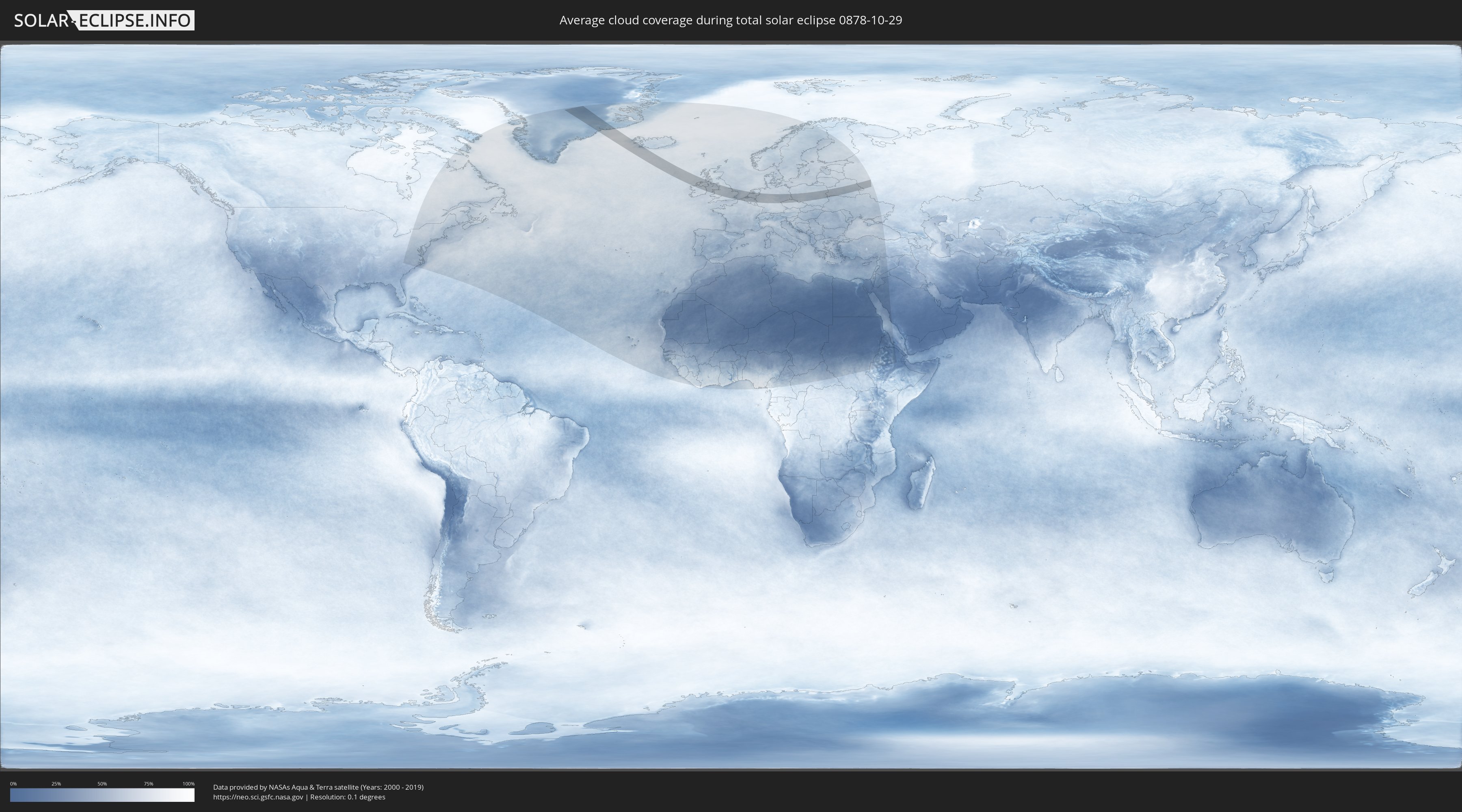
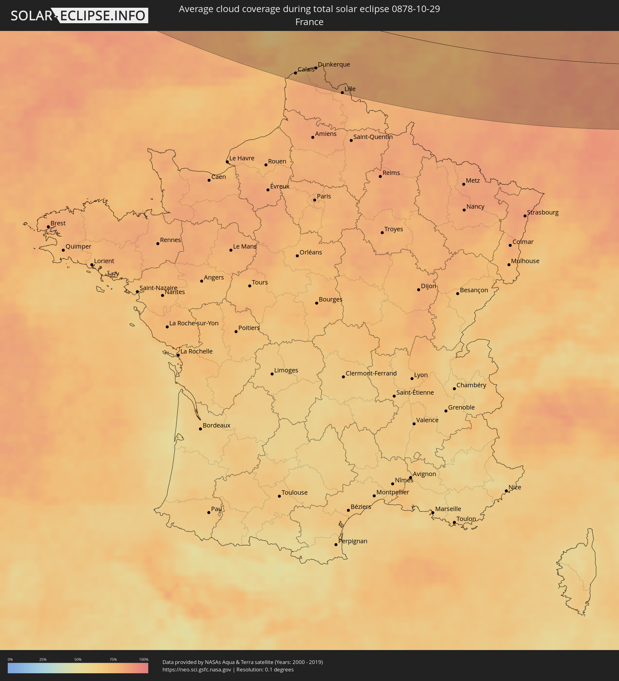
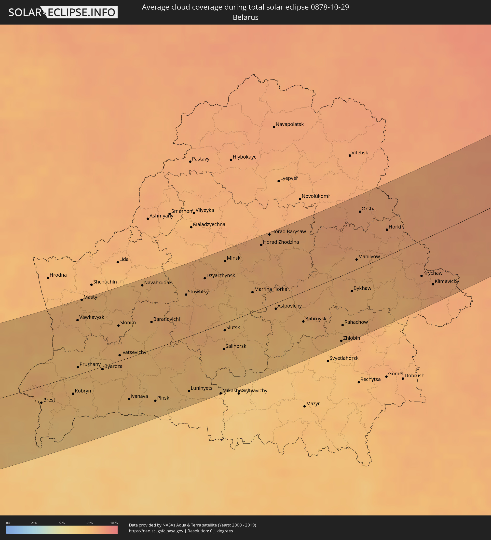
Wie wird das Wetter während der totalen Sonnenfinsternis am 29.10.0878?
Wo ist der beste Ort, um die totale Sonnenfinsternis vom 29.10.0878 zu beobachten?
Die folgenden Karten zeigen die durchschnittliche Bewölkung für den Tag, an dem die totale Sonnenfinsternis
stattfindet. Mit Hilfe der Karten lässt sich der Ort entlang des Finsternispfades eingrenzen,
der die besten Aussichen auf einen klaren wolkenfreien Himmel bietet.
Trotzdem muss man immer lokale Gegenenheiten beachten und sollte sich genau über das Wetter an seinem
gewählten Beobachtungsort informieren.
Die Daten stammen von den beiden NASA-Satelliten
AQUA und TERRA
und wurden über einen Zeitraum von 19 Jahren (2000 - 2019) gemittelt.

Detaillierte Länderkarten
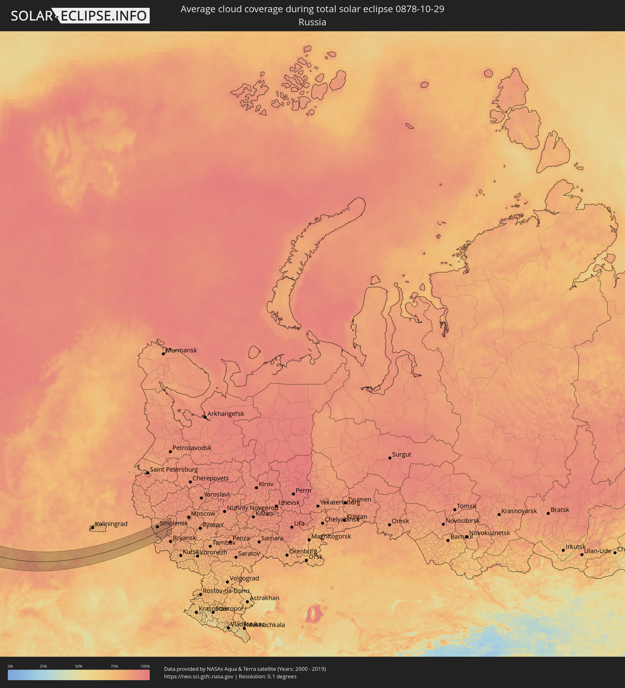 Russland
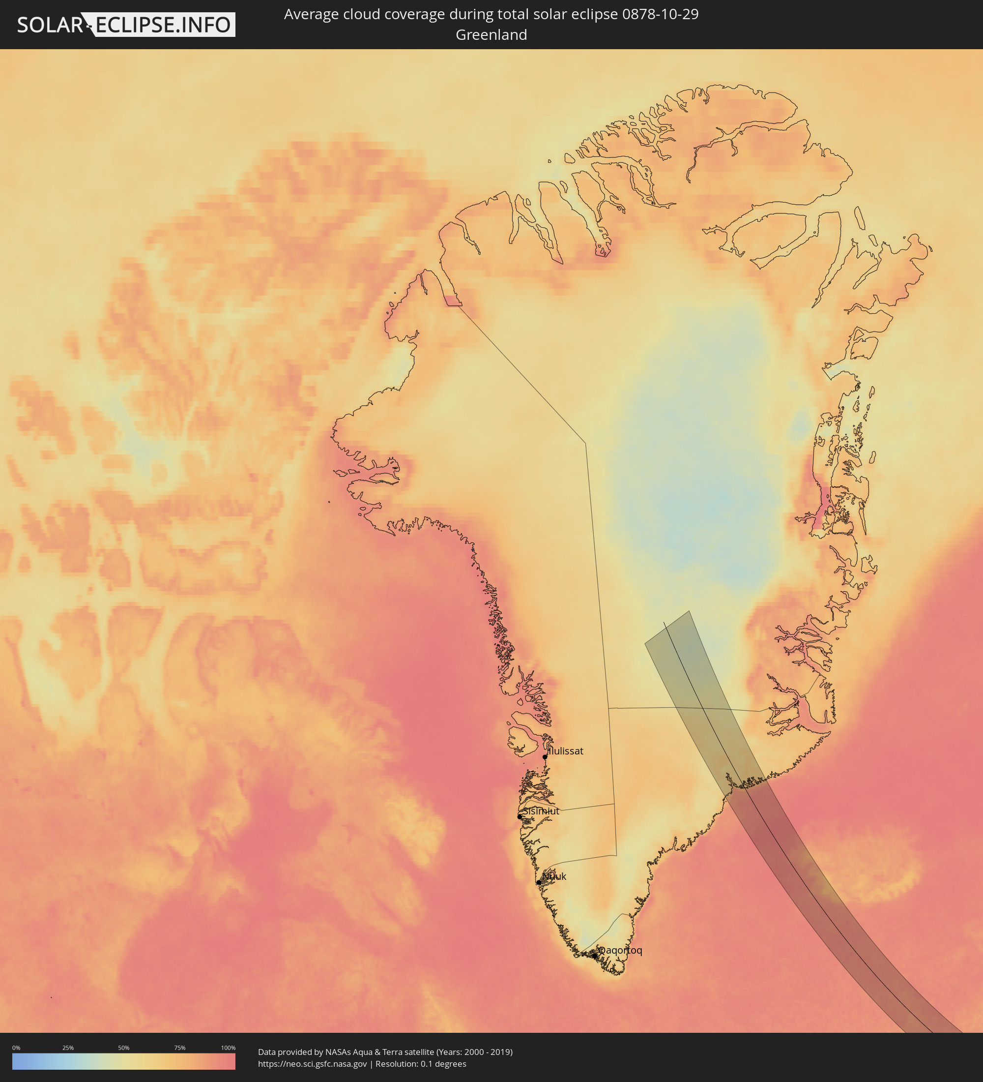 Grönland
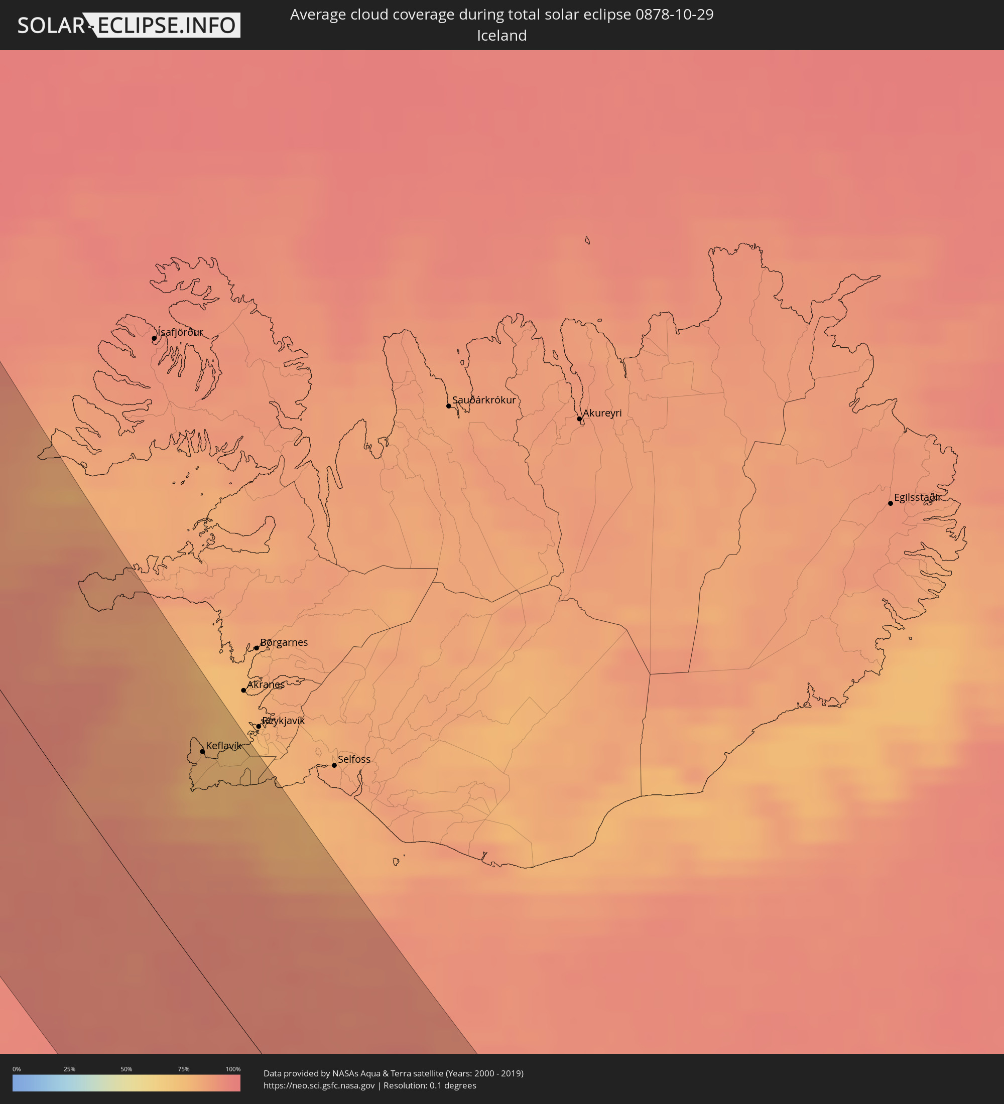 Island
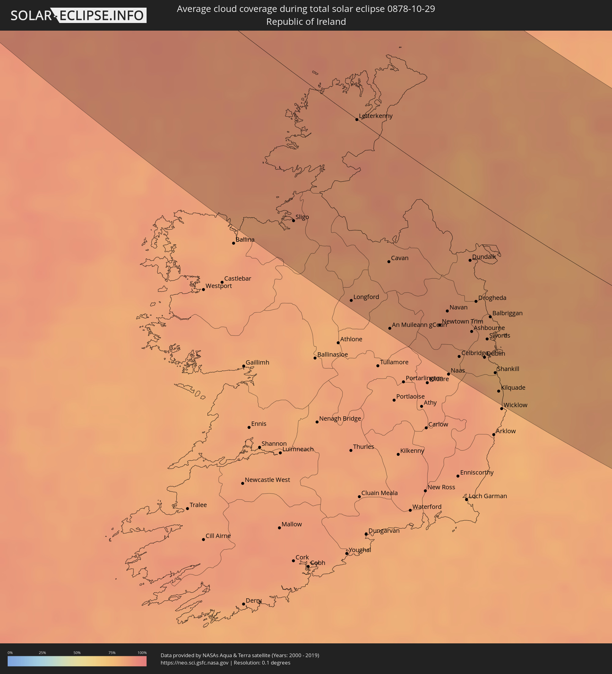 Irland
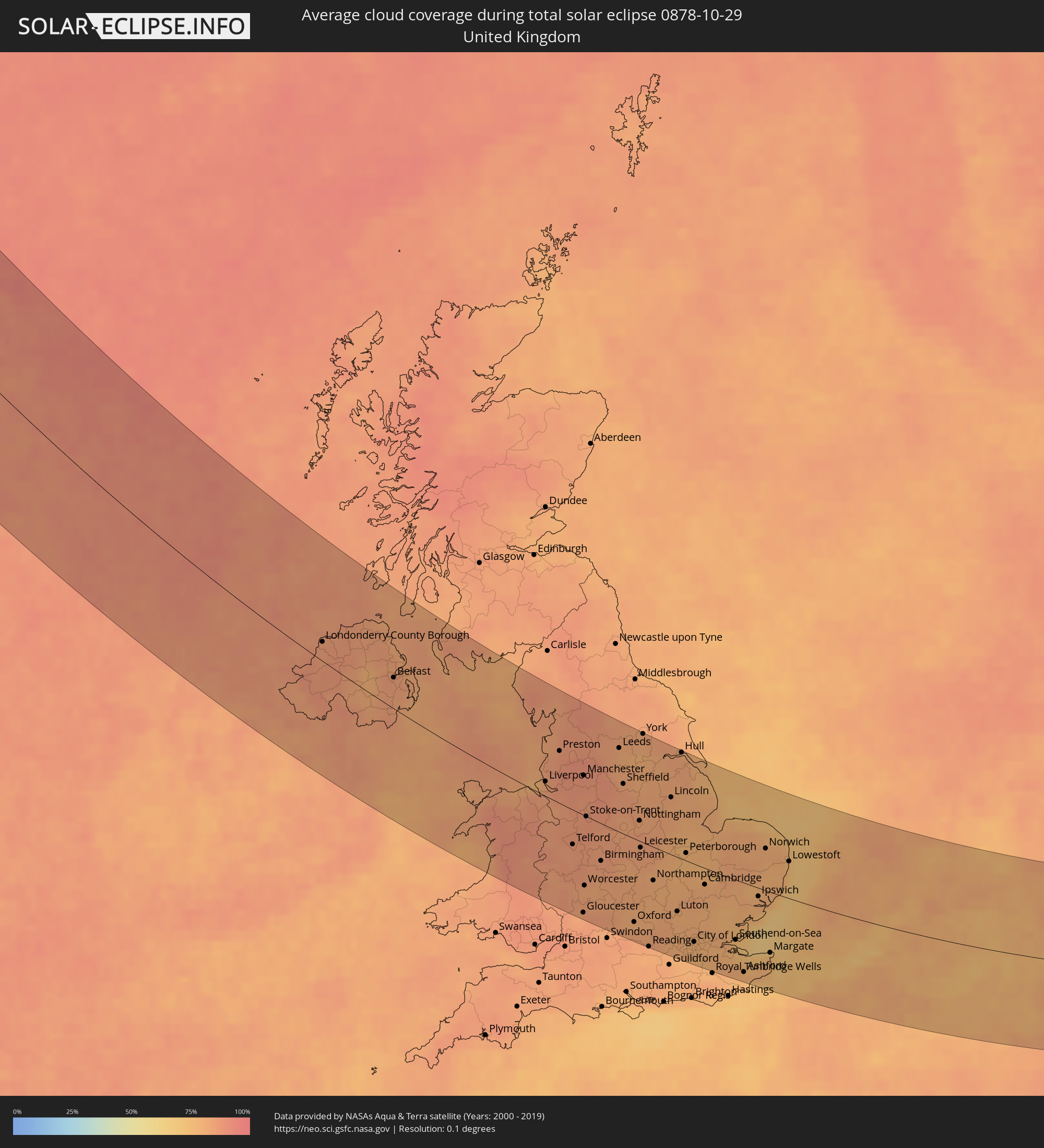 Vereinigtes Königreich
 Frankreich
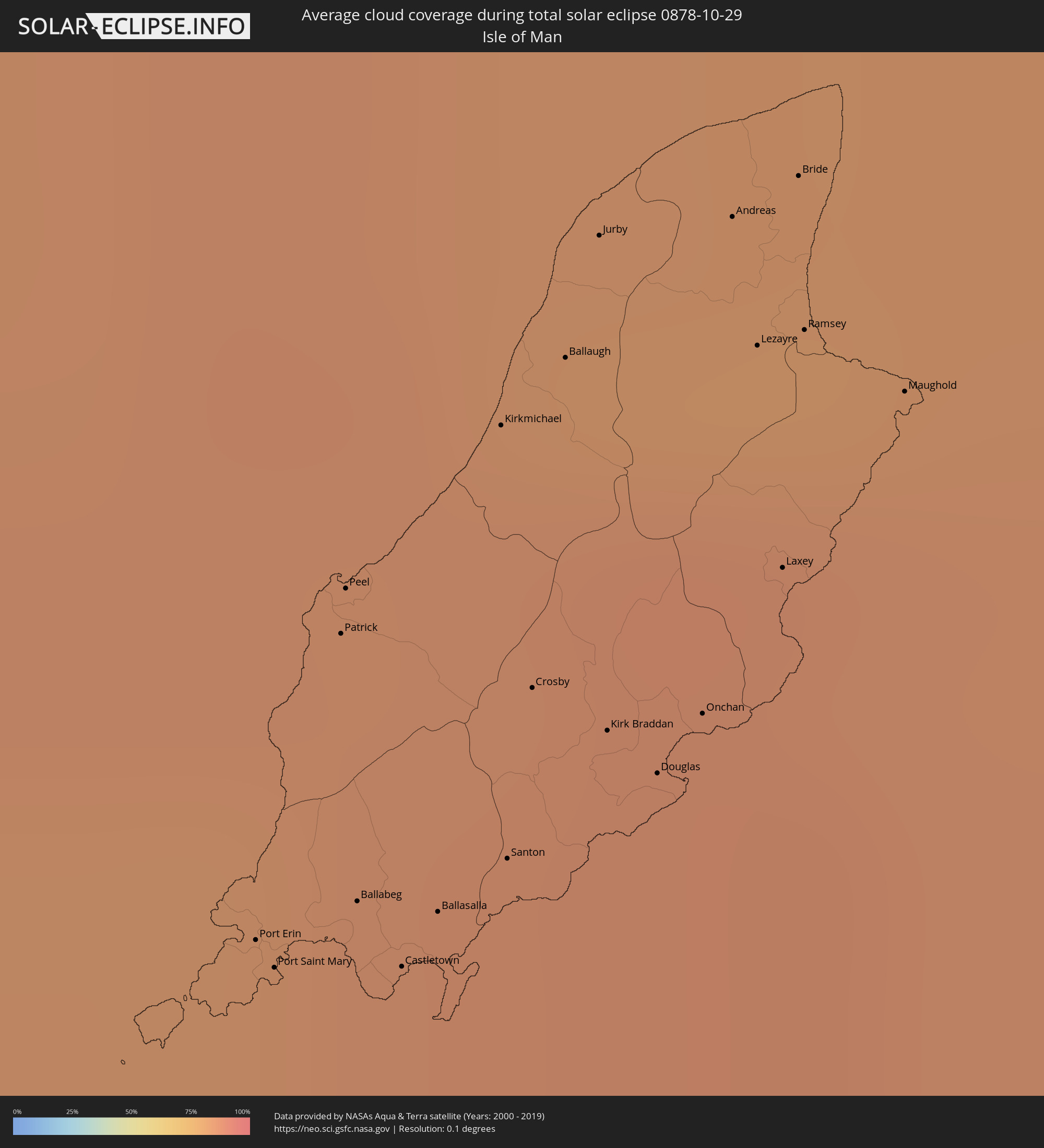 Isle of Man
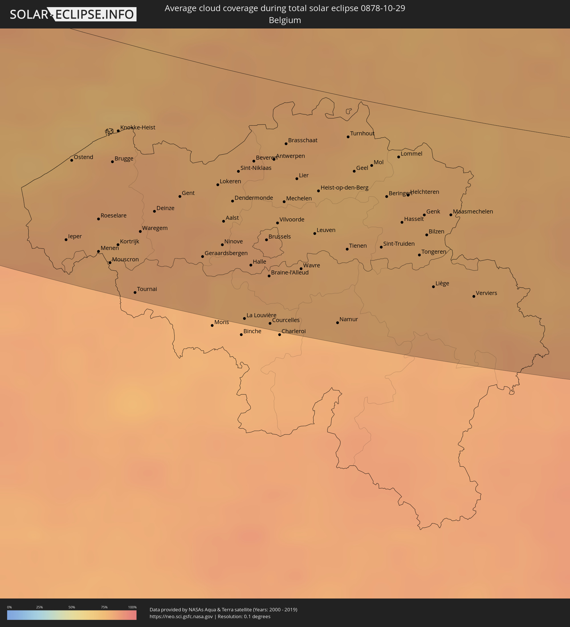 Belgien
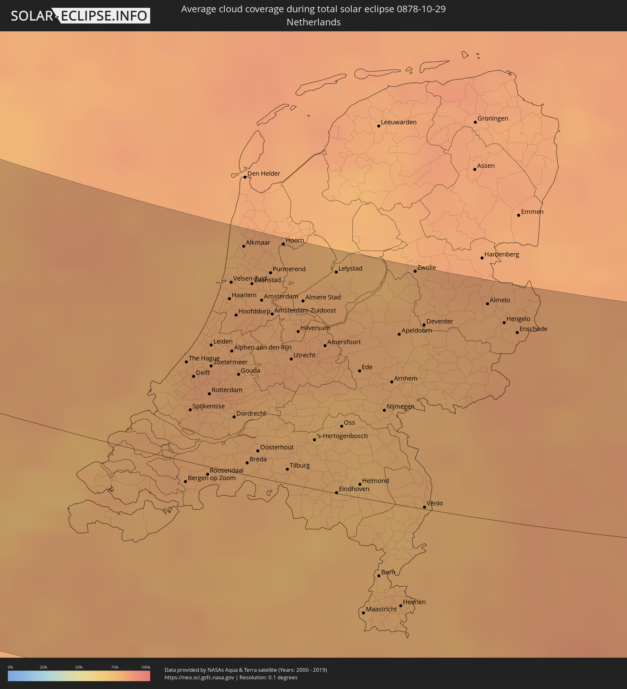 Niederlande
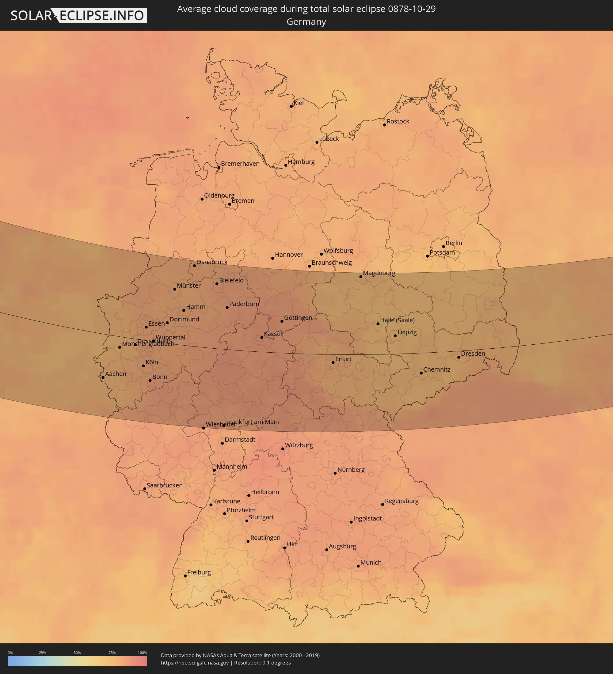 Deutschland
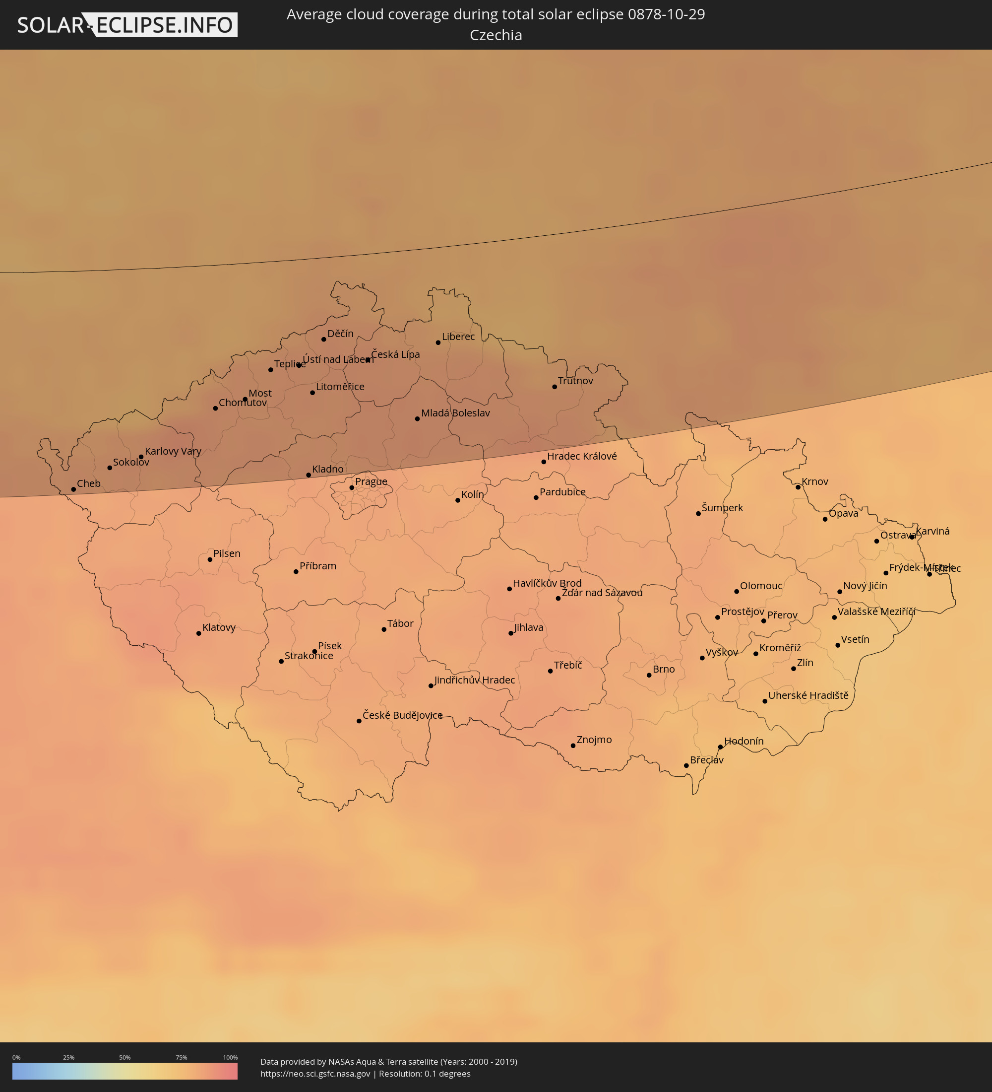 Tschechien
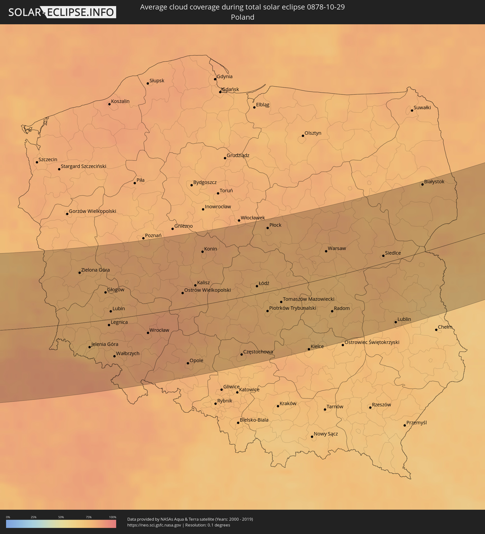 Polen
Polen
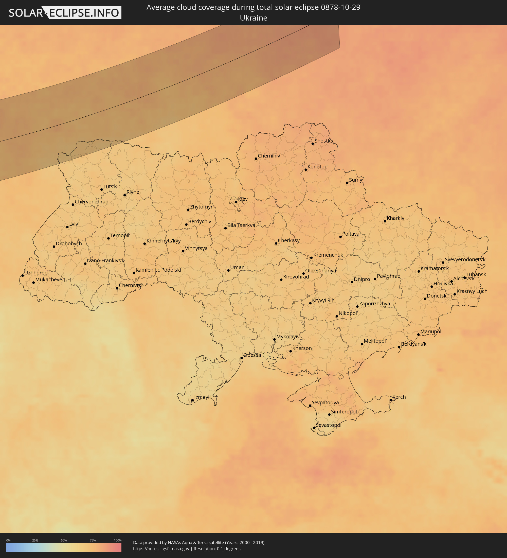 Ukraine
 Weißrussland
Orte im Finsternispfad
Die nachfolgene Tabelle zeigt Städte und Orte mit mehr als 5.000 Einwohnern, die sich im Finsternispfad befinden. Städte mit mehr als 100.000 Einwohnern sind dick gekennzeichnet. Mit einem Klick auf den Ort öffnet sich eine Detailkarte die die Lage des jeweiligen Ortes zusammen mit dem Verlauf der zentralen Finsternis präsentiert.
| Ort | Typ | Dauer der Verfinsterung | Ortszeit bei maximaler Verfinsterung | Entfernung zur Zentrallinie | Ø Bewölkung |
|
Keflavík, Southern Peninsula
|
total | - | 11:26:27 UTC-01:28 | 76 km | 76% |
|
Sligo, Connaught
|
total | - | 12:48:33 UTC-00:25 | 90 km | 84% |
|
Longford, Leinster
|
total | - | 12:49:52 UTC-00:25 | 115 km | 83% |
|
Letterkenny, Ulster
|
total | - | 12:49:04 UTC-00:25 | 0 km | 84% |
|
Cavan, Ulster
|
total | - | 12:50:16 UTC-00:25 | 75 km | 83% |
|
An Muileann gCearr, Leinster
|
total | - | 12:50:38 UTC-00:25 | 117 km | 81% |
|
Monaghan, Ulster
|
total | - | 12:50:37 UTC-00:25 | 37 km | 87% |
|
Navan, Leinster
|
total | - | 12:51:28 UTC-00:25 | 82 km | 86% |
|
Celbridge, Leinster
|
total | - | 12:51:54 UTC-00:25 | 107 km | 82% |
|
Hartstown, Leinster
|
total | - | 12:52:01 UTC-00:25 | 98 km | 82% |
|
Dundalk, Leinster
|
total | - | 12:51:33 UTC-00:25 | 40 km | 83% |
|
Ashbourne, Leinster
|
total | - | 12:51:58 UTC-00:25 | 86 km | 83% |
|
Drogheda, Leinster
|
total | - | 12:51:52 UTC-00:25 | 64 km | 83% |
|
Ballymun, Leinster
|
total | - | 12:52:14 UTC-00:25 | 92 km | 81% |
|
Dublin, Leinster
|
total | - | 12:52:18 UTC-00:25 | 98 km | 78% |
|
Balbriggan, Leinster
|
total | - | 12:52:11 UTC-00:25 | 69 km | 82% |
|
Kilquade
|
total | - | 12:52:44 UTC-00:25 | 114 km | 82% |
|
Belfast, Northern Ireland
|
total | - | 13:17:05 UTC+00:00 | 33 km | 83% |
|
Port Erin, Port Erin
|
total | - | 13:19:05 UTC+00:00 | 25 km | 83% |
|
Port Saint Mary, Port St Mary
|
total | - | 13:19:06 UTC+00:00 | 24 km | 84% |
|
Peel, Peel
|
total | - | 13:19:02 UTC+00:00 | 40 km | 84% |
|
Ballasalla, Malew
|
total | - | 13:19:14 UTC+00:00 | 30 km | 85% |
|
Kirkmichael, Michael
|
total | - | 13:19:07 UTC+00:00 | 50 km | 85% |
|
Santon, Santon
|
total | - | 13:19:16 UTC+00:00 | 34 km | 85% |
|
Crosby, Marown
|
total | - | 13:19:14 UTC+00:00 | 41 km | 85% |
|
Ballaugh, Ballaugh
|
total | - | 13:19:10 UTC+00:00 | 54 km | 86% |
|
Jurby, Jurby
|
total | - | 13:19:09 UTC+00:00 | 59 km | 81% |
|
Kirk Braddan, Braddan
|
total | - | 13:19:19 UTC+00:00 | 41 km | 86% |
|
Douglas, Douglas
|
total | - | 13:19:23 UTC+00:00 | 40 km | 86% |
|
Onchan, Onchan
|
total | - | 13:19:24 UTC+00:00 | 43 km | 86% |
|
Andreas, Andreas
|
total | - | 13:19:16 UTC+00:00 | 63 km | 81% |
|
Lezayre, Lezayre
|
total | - | 13:19:20 UTC+00:00 | 58 km | 85% |
|
Bride, Bride
|
total | - | 13:19:18 UTC+00:00 | 66 km | 81% |
|
Ramsey, Ramsey
|
total | - | 13:19:22 UTC+00:00 | 60 km | 85% |
|
Liverpool, England
|
total | - | 13:22:04 UTC+00:00 | 17 km | 83% |
|
Manchester, England
|
total | - | 13:22:59 UTC+00:00 | 46 km | 87% |
|
Stoke-on-Trent, England
|
total | - | 13:23:31 UTC+00:00 | 0 km | 87% |
|
Wolverhampton, England
|
total | - | 13:24:00 UTC+00:00 | 40 km | 85% |
|
Birmingham, England
|
total | - | 13:24:25 UTC+00:00 | 45 km | 84% |
|
Leeds, England
|
total | - | 13:23:36 UTC+00:00 | 98 km | 79% |
|
Coventry, England
|
total | - | 13:25:01 UTC+00:00 | 41 km | 82% |
|
Derby, England
|
total | - | 13:24:33 UTC+00:00 | 12 km | 82% |
|
Sheffield, England
|
total | - | 13:24:07 UTC+00:00 | 59 km | 85% |
|
Nottingham, England
|
total | - | 13:24:58 UTC+00:00 | 24 km | 81% |
|
Leicester, England
|
total | - | 13:25:18 UTC+00:00 | 7 km | 84% |
|
Reading, England
|
total | - | 13:26:44 UTC+00:00 | 125 km | 80% |
|
Hull, England
|
total | - | 13:25:14 UTC+00:00 | 127 km | 83% |
|
London, England
|
total | - | 13:27:51 UTC+00:00 | 98 km | 77% |
|
Bexley, England
|
total | - | 13:28:18 UTC+00:00 | 99 km | 78% |
|
Calais, Hauts-de-France
|
total | - | 13:40:31 UTC+00:09 | 113 km | 76% |
|
Grand-Fort-Philippe, Hauts-de-France
|
total | - | 13:40:48 UTC+00:09 | 103 km | 78% |
|
Gravelines, Hauts-de-France
|
total | - | 13:40:51 UTC+00:09 | 104 km | 78% |
|
Bourbourg, Hauts-de-France
|
total | - | 13:40:59 UTC+00:09 | 107 km | 80% |
|
Loon-Plage, Hauts-de-France
|
total | - | 13:40:58 UTC+00:09 | 101 km | 79% |
|
Cappelle-la-Grande, Hauts-de-France
|
total | - | 13:41:09 UTC+00:09 | 98 km | 80% |
|
Dunkerque, Hauts-de-France
|
total | - | 13:41:08 UTC+00:09 | 94 km | 80% |
|
Téteghem, Hauts-de-France
|
total | - | 13:41:14 UTC+00:09 | 94 km | 80% |
|
Hazebrouck, Hauts-de-France
|
total | - | 13:41:42 UTC+00:09 | 124 km | 81% |
|
Nieppe, Hauts-de-France
|
total | - | 13:42:08 UTC+00:09 | 121 km | 80% |
|
Houplines, Hauts-de-France
|
total | - | 13:42:15 UTC+00:09 | 120 km | 80% |
|
Ostend, Flanders
|
total | - | 13:32:19 UTC+00:00 | 64 km | 77% |
|
Pérenchies, Hauts-de-France
|
total | - | 13:42:21 UTC+00:09 | 122 km | 79% |
|
Quesnoy-sur-Deûle, Hauts-de-France
|
total | - | 13:42:21 UTC+00:09 | 117 km | 79% |
|
Lille, Hauts-de-France
|
total | - | 13:42:31 UTC+00:09 | 125 km | 80% |
|
Linselles, Hauts-de-France
|
total | - | 13:42:25 UTC+00:09 | 113 km | 79% |
|
Roeselare, Flanders
|
total | - | 13:32:53 UTC+00:00 | 90 km | 79% |
|
Halluin, Hauts-de-France
|
total | - | 13:33:05 UTC+00:00 | 107 km | 78% |
|
Brugge, Flanders
|
total | - | 13:32:43 UTC+00:00 | 60 km | 79% |
|
Kortrijk, Flanders
|
total | - | 13:33:13 UTC+00:00 | 100 km | 79% |
|
Tournai, Wallonia
|
total | - | 13:33:39 UTC+00:00 | 122 km | 79% |
|
Gent, Flanders
|
total | - | 13:33:33 UTC+00:00 | 68 km | 80% |
|
Aalst, Flanders
|
total | - | 13:34:07 UTC+00:00 | 76 km | 79% |
|
Sint-Niklaas, Flanders
|
total | - | 13:33:59 UTC+00:00 | 49 km | 77% |
|
La Louvière, Wallonia
|
total | - | 13:34:51 UTC+00:00 | 122 km | 78% |
|
The Hague, South Holland
|
total | - | 13:52:37 UTC+00:19 | 52 km | 80% |
|
Brussels, Brussels Capital
|
total | - | 13:34:38 UTC+00:00 | 80 km | 80% |
|
Antwerpen, Flanders
|
total | - | 13:34:15 UTC+00:00 | 39 km | 76% |
|
Mechelen, Flanders
|
total | - | 13:34:35 UTC+00:00 | 59 km | 76% |
|
Rotterdam, South Holland
|
total | - | 13:53:02 UTC+00:19 | 38 km | 79% |
|
Haarlem, North Holland
|
total | - | 13:52:41 UTC+00:19 | 90 km | 79% |
|
Leuven, Flanders
|
total | - | 13:35:03 UTC+00:00 | 72 km | 77% |
|
Breda, North Brabant
|
total | - | 13:53:49 UTC+00:19 | 6 km | 76% |
|
Namur, Wallonia
|
total | - | 13:35:47 UTC+00:00 | 114 km | 78% |
|
Amsterdam, North Holland
|
total | - | 13:53:00 UTC+00:19 | 94 km | 80% |
|
Tilburg, North Brabant
|
total | - | 13:54:16 UTC+00:19 | 8 km | 78% |
|
Utrecht, Utrecht
|
total | - | 13:53:39 UTC+00:19 | 66 km | 80% |
|
Almere Stad, Flevoland
|
total | - | 13:53:25 UTC+00:19 | 98 km | 79% |
|
's-Hertogenbosch, North Brabant
|
total | - | 13:54:21 UTC+00:19 | 26 km | 76% |
|
Hasselt, Flanders
|
total | - | 13:35:49 UTC+00:00 | 57 km | 77% |
|
Amersfoort, Utrecht
|
total | - | 13:53:54 UTC+00:19 | 77 km | 81% |
|
Eindhoven, North Brabant
|
total | - | 13:54:54 UTC+00:19 | 0 km | 74% |
|
Liège, Wallonia
|
total | - | 13:36:29 UTC+00:00 | 87 km | 78% |
|
Maastricht, Limburg
|
total | - | 13:55:54 UTC+00:19 | 62 km | 76% |
|
Nijmegen, Gelderland
|
total | - | 13:54:52 UTC+00:19 | 49 km | 77% |
|
Arnhem, Gelderland
|
total | - | 13:54:46 UTC+00:19 | 65 km | 78% |
|
Apeldoorn, Gelderland
|
total | - | 13:54:33 UTC+00:19 | 91 km | 77% |
|
Aachen, North Rhine-Westphalia
|
total | - | 14:36:58 UTC+01:00 | 65 km | 77% |
|
Mönchengladbach, North Rhine-Westphalia
|
total | - | 14:36:54 UTC+01:00 | 16 km | 76% |
|
Krefeld, North Rhine-Westphalia
|
total | - | 14:36:53 UTC+01:00 | 2 km | 77% |
|
Duisburg, North Rhine-Westphalia
|
total | - | 14:37:00 UTC+01:00 | 14 km | 80% |
|
Düsseldorf, North Rhine-Westphalia
|
total | - | 14:37:17 UTC+01:00 | 9 km | 79% |
|
Enschede, Overijssel
|
total | - | 13:55:41 UTC+00:19 | 102 km | 80% |
|
Köln, North Rhine-Westphalia
|
total | - | 14:37:52 UTC+01:00 | 39 km | 82% |
|
Essen, North Rhine-Westphalia
|
total | - | 14:37:16 UTC+01:00 | 19 km | 80% |
|
Bonn, North Rhine-Westphalia
|
total | - | 14:38:18 UTC+01:00 | 60 km | 83% |
|
Wuppertal, North Rhine-Westphalia
|
total | - | 14:37:42 UTC+01:00 | 0 km | 81% |
|
Dortmund, North Rhine-Westphalia
|
total | - | 14:37:45 UTC+01:00 | 30 km | 83% |
|
Münster, North Rhine-Westphalia
|
total | - | 14:37:22 UTC+01:00 | 81 km | 79% |
|
Bielefeld, North Rhine-Westphalia
|
total | - | 14:38:22 UTC+01:00 | 95 km | 83% |
|
Frankfurt am Main, Hesse
|
total | - | 14:41:06 UTC+01:00 | 116 km | 83% |
|
Leipzig, Saxony
|
total | - | 14:43:44 UTC+01:00 | 27 km | 75% |
|
Cheb, Karlovarský
|
total | - | 14:45:32 UTC+01:00 | 114 km | 83% |
|
Sokolov, Karlovarský
|
total | - | 14:45:41 UTC+01:00 | 103 km | 82% |
|
Karlovy Vary, Karlovarský
|
total | - | 14:45:53 UTC+01:00 | 98 km | 83% |
|
Chemnitz, Saxony
|
total | - | 14:45:05 UTC+01:00 | 31 km | 76% |
|
Chomutov, Ústecký
|
total | - | 14:46:10 UTC+01:00 | 74 km | 84% |
|
Žatec, Ústecký
|
total | - | 14:46:30 UTC+01:00 | 90 km | 83% |
|
Most, Ústecký
|
total | - | 14:46:20 UTC+01:00 | 70 km | 83% |
|
Dresden, Saxony
|
total | - | 14:45:39 UTC+01:00 | 10 km | 75% |
|
Ústí nad Labem, Ústecký
|
total | - | 14:46:32 UTC+01:00 | 55 km | 84% |
|
Kladno, Central Bohemia
|
total | - | 14:47:22 UTC+01:00 | 112 km | 83% |
|
Litoměřice, Ústecký
|
total | - | 14:46:50 UTC+01:00 | 69 km | 82% |
|
Děčín, Ústecký
|
total | - | 14:46:34 UTC+01:00 | 42 km | 83% |
|
Mělník, Central Bohemia
|
total | - | 14:47:28 UTC+01:00 | 92 km | 85% |
|
Česká Lípa, Liberecký
|
total | - | 14:47:03 UTC+01:00 | 55 km | 84% |
|
Mladá Boleslav, Central Bohemia
|
total | - | 14:47:51 UTC+01:00 | 88 km | 86% |
|
Liberec, Liberecký
|
total | - | 14:47:29 UTC+01:00 | 49 km | 82% |
|
Zielona Góra, Lubusz
|
total | - | 15:10:13 UTC+01:24 | 77 km | 78% |
|
Jelenia Góra, Lower Silesian Voivodeship
|
total | - | 15:11:59 UTC+01:24 | 40 km | 72% |
|
Trutnov, Královéhradecký
|
total | - | 14:48:41 UTC+01:00 | 79 km | 83% |
|
Legnica, Lower Silesian Voivodeship
|
total | - | 15:11:58 UTC+01:24 | 9 km | 79% |
|
Náchod, Královéhradecký
|
total | - | 14:49:09 UTC+01:00 | 97 km | 83% |
|
Wałbrzych, Lower Silesian Voivodeship
|
total | - | 15:12:45 UTC+01:24 | 59 km | 78% |
|
Wrocław, Lower Silesian Voivodeship
|
total | - | 15:13:00 UTC+01:24 | 30 km | 81% |
|
Opole, Opole Voivodeship
|
total | - | 15:14:32 UTC+01:24 | 86 km | 81% |
|
Kalisz, Greater Poland Voivodeship
|
total | - | 15:13:02 UTC+01:24 | 31 km | 79% |
|
Konin, Greater Poland Voivodeship
|
total | - | 15:12:29 UTC+01:24 | 80 km | 78% |
|
Częstochowa, Silesian Voivodeship
|
total | - | 15:15:30 UTC+01:24 | 88 km | 75% |
|
Łódź, Łódź Voivodeship
|
total | - | 15:14:20 UTC+01:24 | 11 km | 73% |
|
Płock, Masovian Voivodeship
|
total | - | 15:13:19 UTC+01:24 | 95 km | 76% |
|
Kielce, Świętokrzyskie
|
total | - | 15:16:46 UTC+01:24 | 102 km | 74% |
|
Warsaw, Masovian Voivodeship
|
total | - | 15:14:58 UTC+01:24 | 40 km | 76% |
|
Radom, Masovian Voivodeship
|
total | - | 15:16:23 UTC+01:24 | 52 km | 72% |
|
Lublin, Lublin Voivodeship
|
total | - | 15:17:51 UTC+01:24 | 93 km | 75% |
|
Białystok, Podlasie
|
total | - | 15:15:20 UTC+01:24 | 97 km | 75% |
|
Brest, Brest
|
total | - | 15:43:25 UTC+01:50 | 23 km | 71% |
|
Shats’k, Volyn
|
total | - | 15:56:38 UTC+02:02 | 92 km | 67% |
|
Kobryn, Brest
|
total | - | 15:43:45 UTC+01:50 | 24 km | 73% |
|
Vawkavysk, Grodnenskaya
|
total | - | 15:42:19 UTC+01:50 | 73 km | 77% |
|
Ratne, Volyn
|
total | - | 15:56:50 UTC+02:02 | 86 km | 70% |
|
Slonim, Grodnenskaya
|
total | - | 15:43:05 UTC+01:50 | 48 km | 76% |
|
Baranovichi, Brest
|
total | - | 15:43:31 UTC+01:50 | 37 km | 74% |
|
Pinsk, Brest
|
total | - | 15:45:13 UTC+01:50 | 71 km | 70% |
|
Salihorsk, Minsk
|
total | - | 15:45:10 UTC+01:50 | 34 km | 72% |
|
Slutsk, Minsk
|
total | - | 15:44:47 UTC+01:50 | 10 km | 75% |
|
Minsk, Minsk City
|
total | - | 15:43:21 UTC+01:50 | 81 km | 77% |
|
Horad Zhodzina, Minsk
|
total | - | 15:43:32 UTC+01:50 | 82 km | 78% |
|
Horad Barysaw, Minsk
|
total | - | 15:43:26 UTC+01:50 | 91 km | 79% |
|
Babruysk, Mogilev
|
total | - | 15:45:42 UTC+01:50 | 39 km | 72% |
|
Zhlobin, Gomel
|
total | - | 15:46:37 UTC+01:50 | 85 km | 75% |
|
Rahachow, Gomel
|
total | - | 15:46:18 UTC+01:50 | 65 km | 74% |
|
Mahilyow, Mogilev
|
total | - | 15:45:07 UTC+01:50 | 12 km | 79% |
|
Orsha, Vitebsk
|
total | - | 15:44:10 UTC+01:50 | 70 km | 82% |
|
Smolensk, Smolensk
|
total | - | 16:24:56 UTC+02:30 | 54 km | 82% |
|
Pochinok, Smolensk
|
total | - | 16:25:47 UTC+02:30 | 5 km | 85% |
|
Yartsevo, Smolensk
|
total | - | 16:24:49 UTC+02:30 | 64 km | 85% |
|
Roslavl’, Smolensk
|
total | - | 16:26:47 UTC+02:30 | 52 km | 82% |
|
Yel’nya, Smolensk
|
total | - | 16:25:54 UTC+02:30 | 2 km | 85% |
|
Safonovo, Smolensk
|
total | - | 16:24:57 UTC+02:30 | 58 km | 85% |
|
Desnogorsk, Smolensk
|
total | - | 16:26:41 UTC+02:30 | 44 km | 83% |
|
Dorogobuzh, Smolensk
|
total | - | 16:25:24 UTC+02:30 | 32 km | 84% |
|
Verkhnedneprovskiy, Smolensk
|
total | - | 16:25:19 UTC+02:30 | 37 km | 86% |
|
Spas-Demensk, Kaluga
|
total | - | 16:26:38 UTC+02:30 | 39 km | 85% |
|
Vyaz’ma, Smolensk
|
total | - | 16:25:25 UTC+02:30 | 33 km | 86% |
|
Kirov, Kaluga
|
total | - | 16:27:21 UTC+02:30 | 81 km | 84% |