Totale Sonnenfinsternis vom 15.02.1059
| Wochentag: | Dienstag |
| Maximale Dauer der Verfinsterung: | 03m26s |
| Maximale Breite des Finsternispfades: | 287 km |
| Saroszyklus: | 115 |
| Bedeckungsgrad: | 100% |
| Magnitude: | 1.0465 |
| Gamma: | 0.8492 |
Wo kann man die Sonnenfinsternis vom 15.02.1059 sehen?
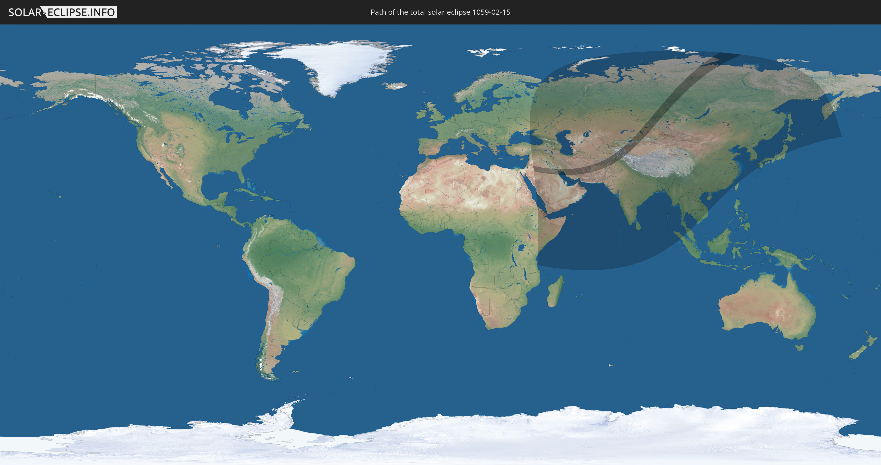
Die Sonnenfinsternis am 15.02.1059 kann man in 53 Ländern als partielle Sonnenfinsternis beobachten.
Der Finsternispfad verläuft durch 12 Länder. Nur in diesen Ländern ist sie als totale Sonnenfinsternis zu sehen.
In den folgenden Ländern ist die Sonnenfinsternis total zu sehen
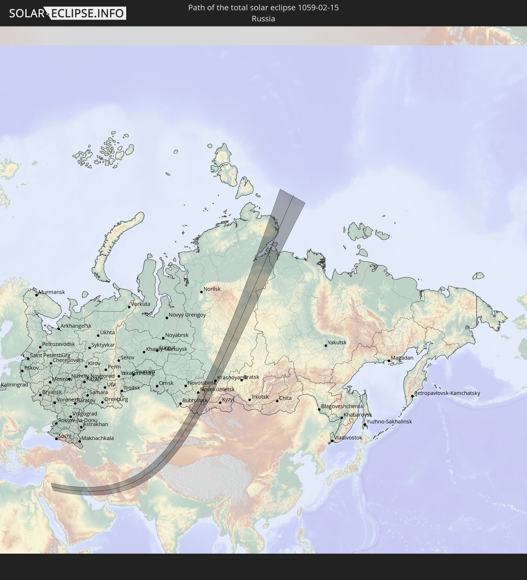 Russland
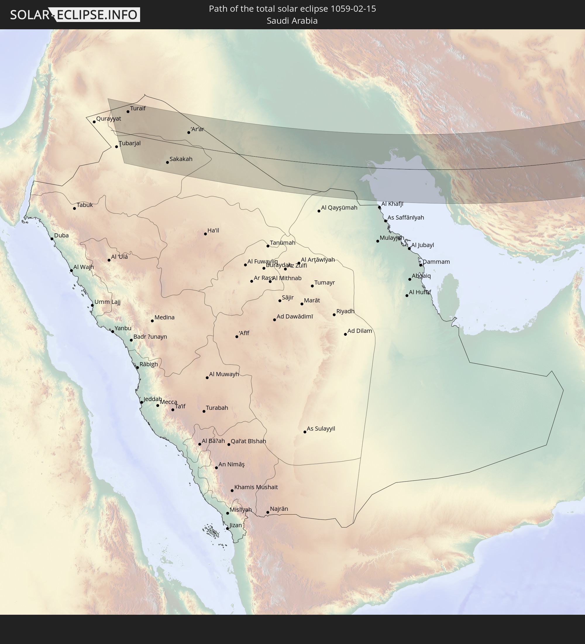 Saudi-Arabien
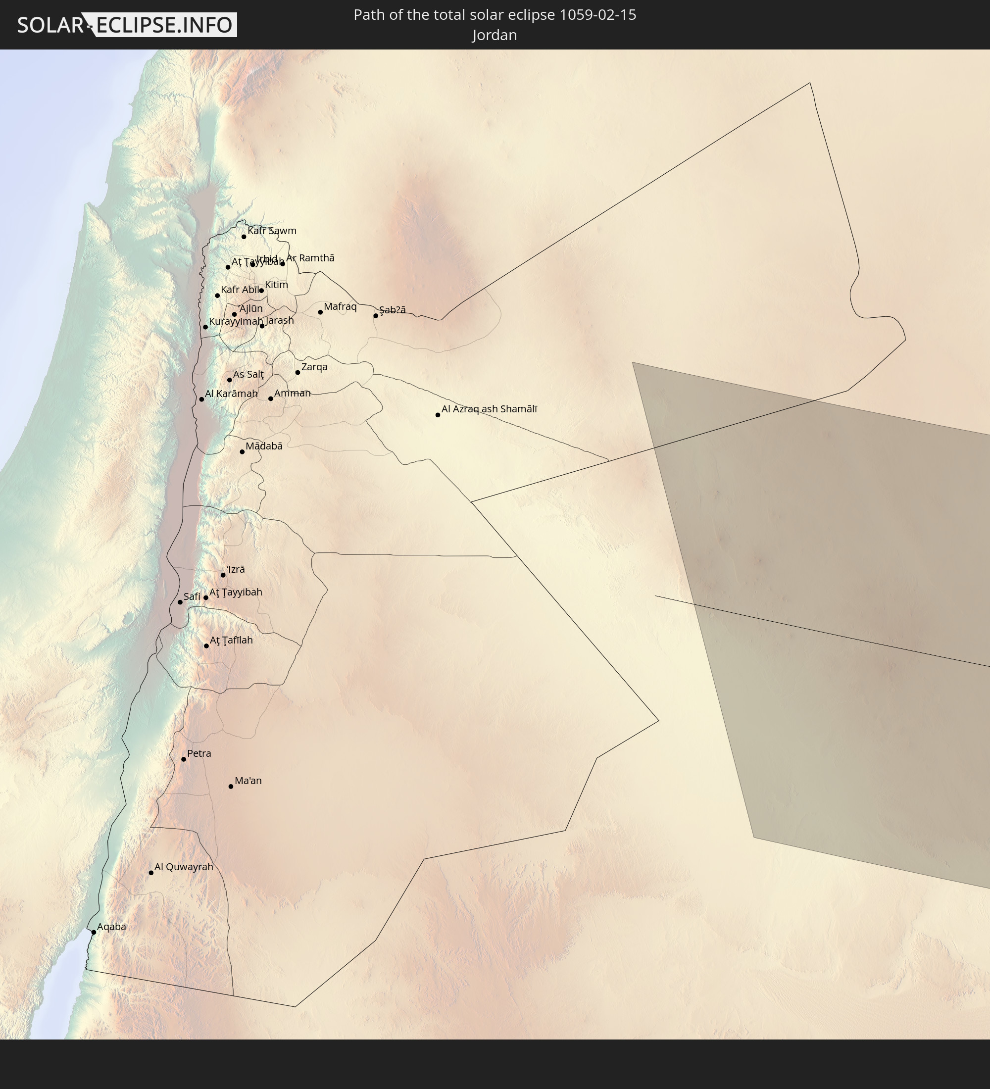 Jordanien
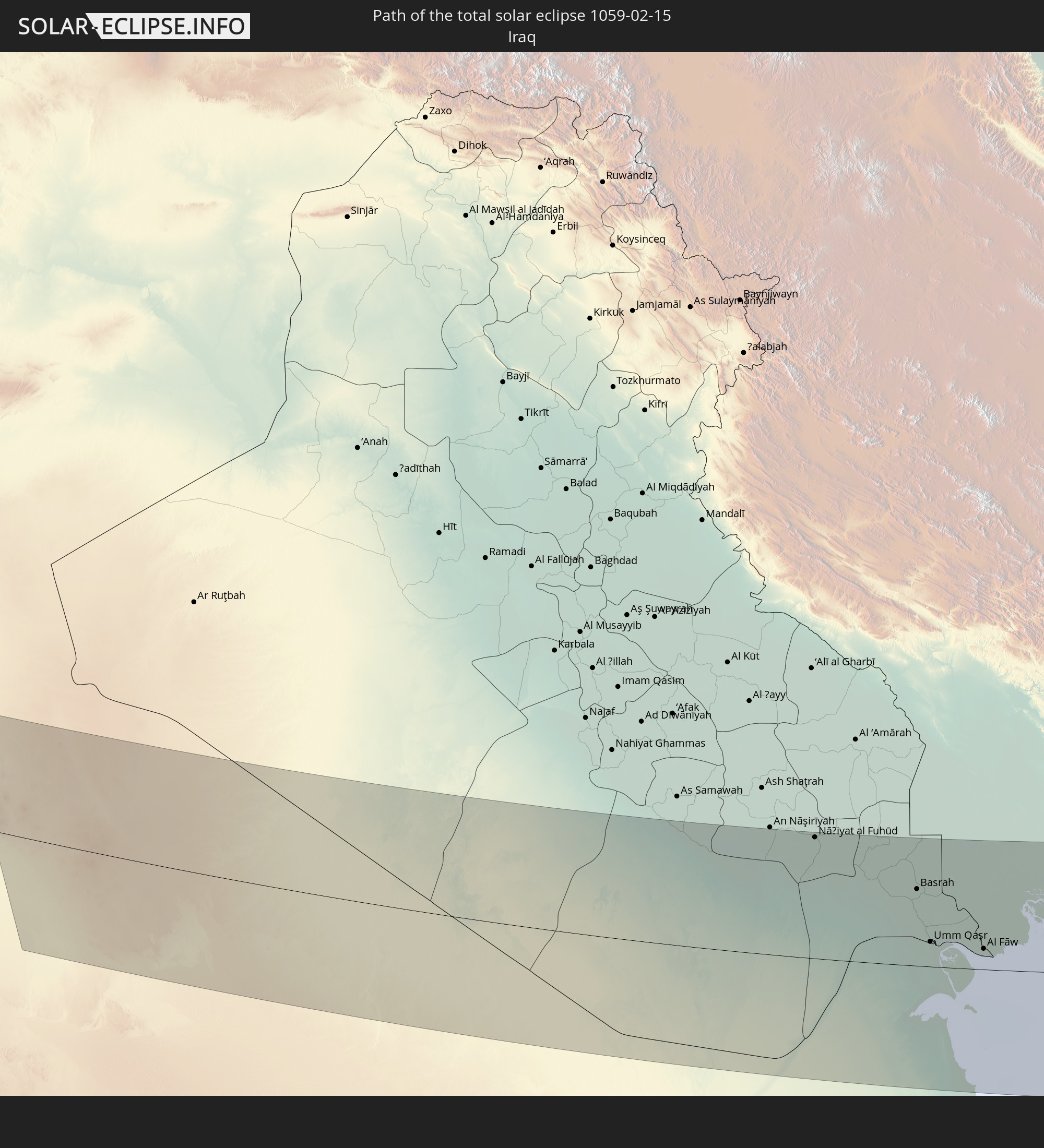 Irak
Irak
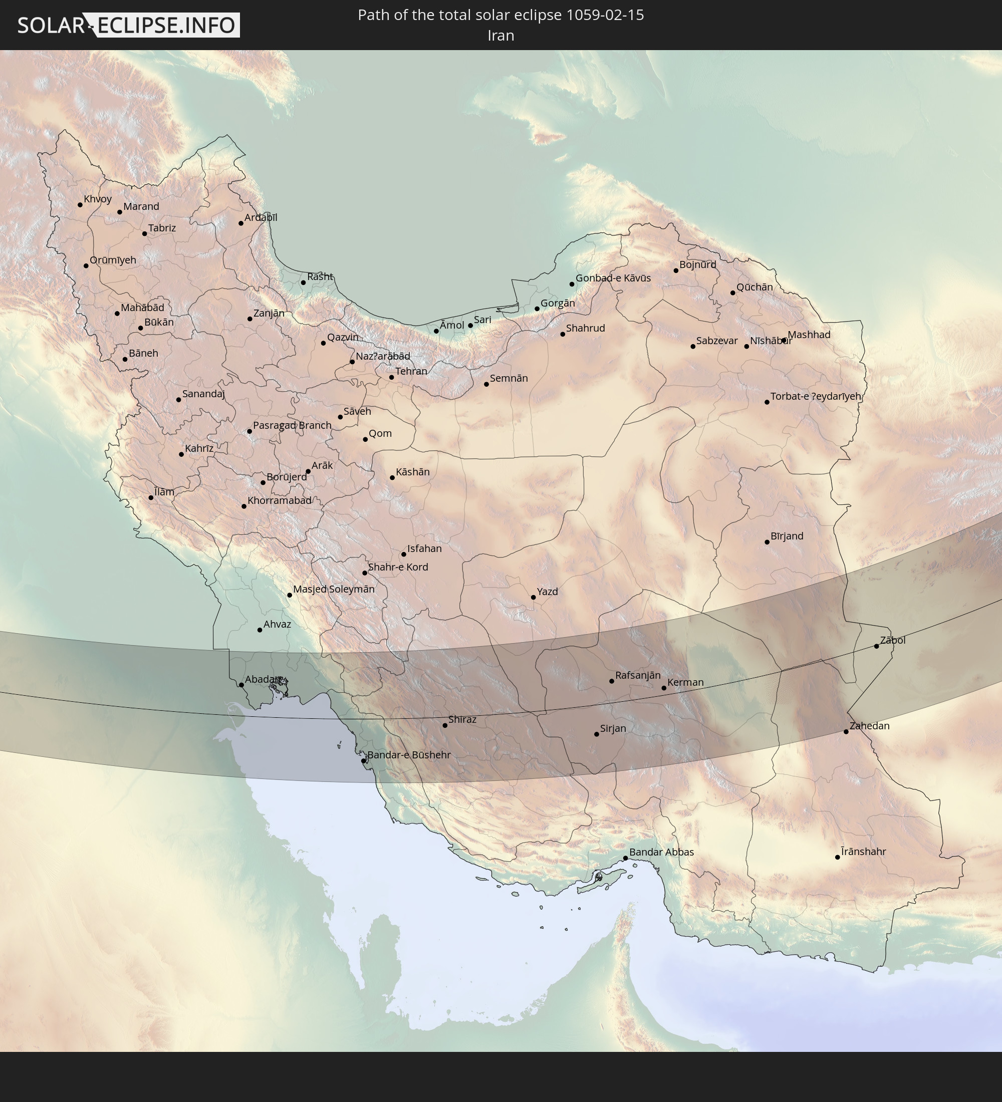 Iran
Iran
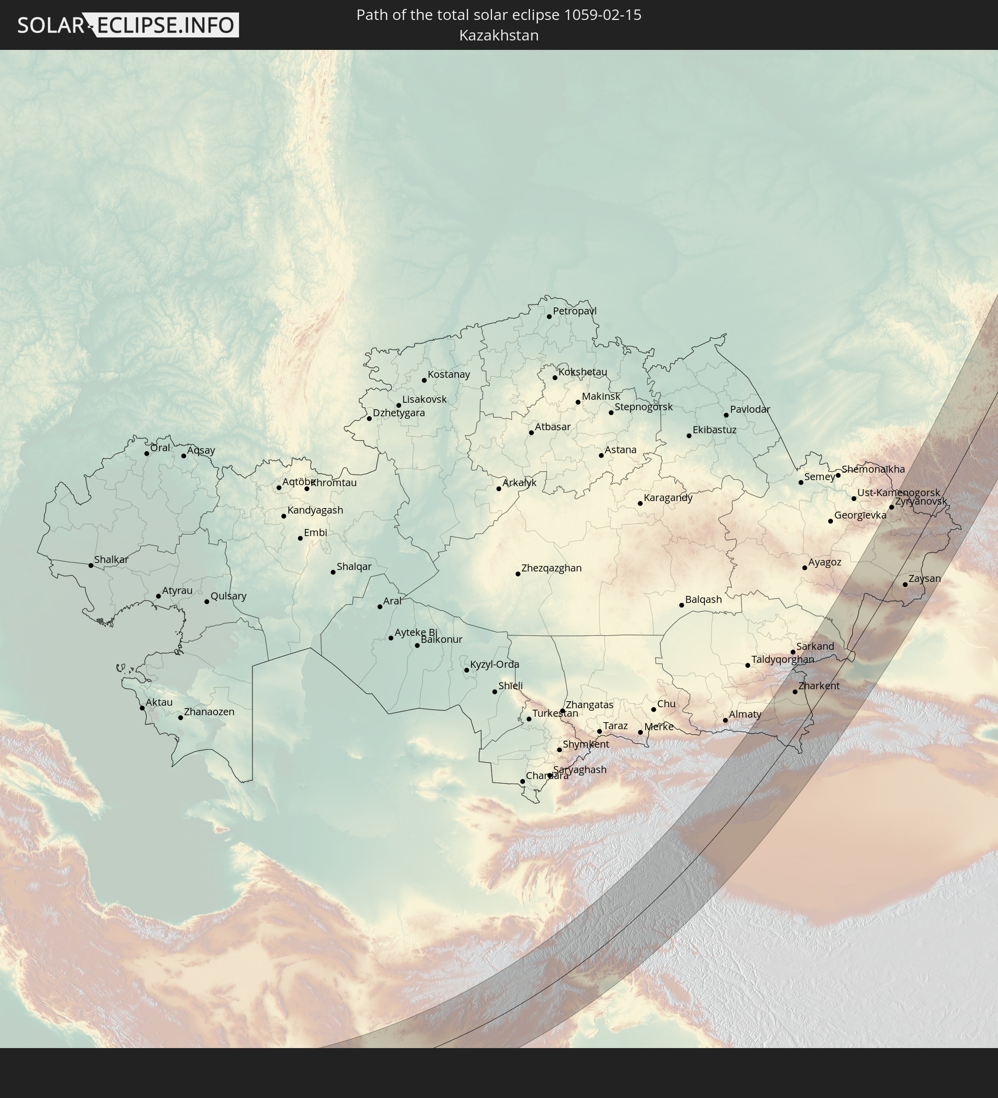 Kasachstan
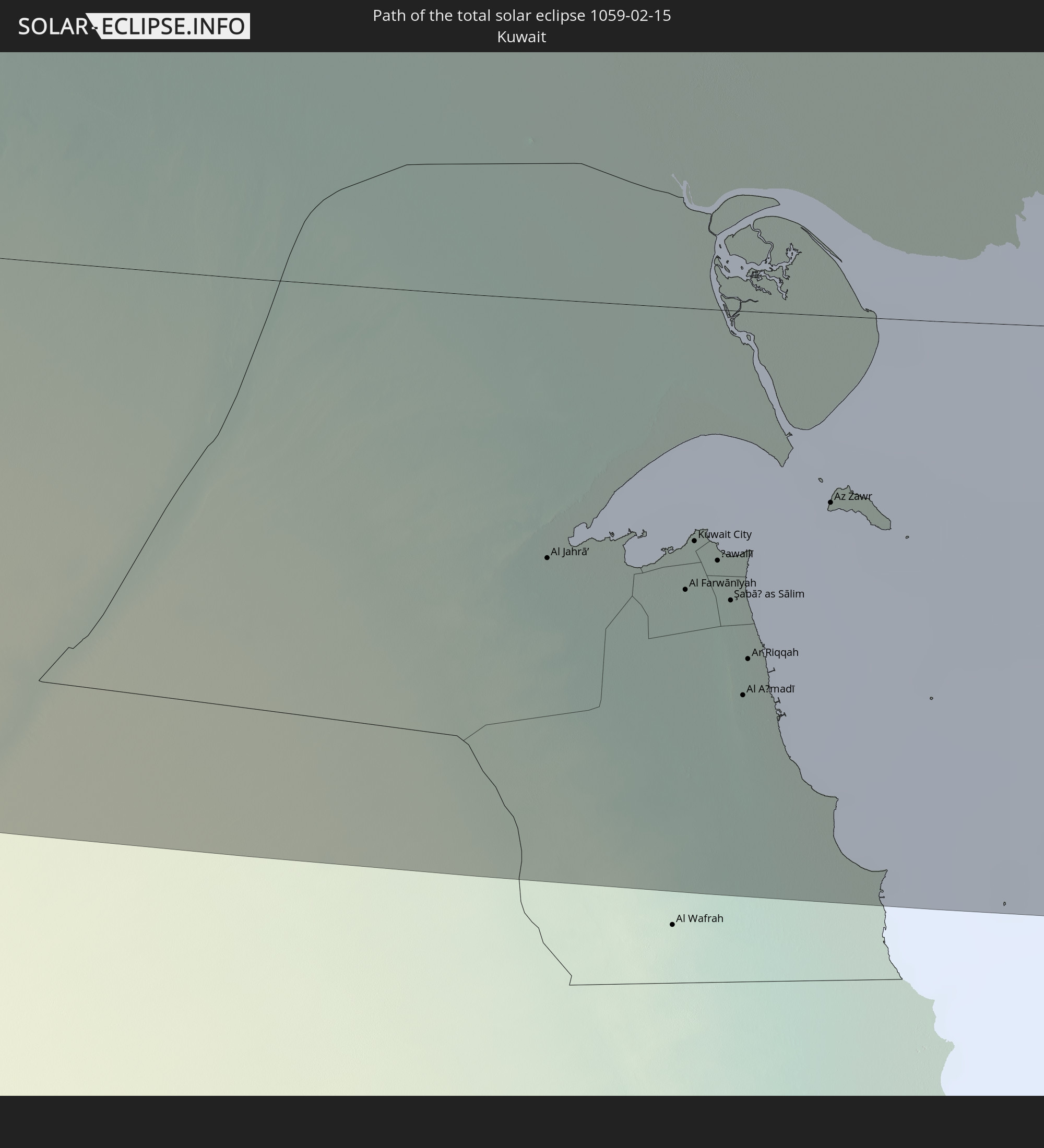 Kuwait
 Afghanistan
 Pakistan
 Tadschikistan
 Kirgisistan
 Volksrepublik China
In den folgenden Ländern ist die Sonnenfinsternis partiell zu sehen
 Russland
 Ukraine
 Türkei
 Tansania
 Äthiopien
 Kenia
Kenia
 Saudi-Arabien
 Jordanien
 Syrien
 Eritrea
 Irak
Irak
 Georgien
 Somalia
 Dschibuti
 Jemen
Jemen
 Armenien
 Iran
Iran
 Aserbaidschan
 Seychellen
 Kasachstan
 Kuwait
 Bahrain
 Katar
Katar
 Vereinigte Arabische Emirate
 Oman
Oman
 Turkmenistan
 Usbekistan
 Afghanistan
 Pakistan
 Tadschikistan
 Indien
 Kirgisistan
 Britisches Territorium im Indischen Ozean
 Malediven
 Volksrepublik China
 Sri Lanka
 Nepal
Nepal
 Mongolei
 Bangladesch
 Bhutan
 Myanmar
 Indonesien
 Thailand
 Malaysia
 Laos
Laos
 Vietnam
 Kambodscha
 Macau
Macau
 Hongkong
 Taiwan
 Japan
Japan
 Nordkorea
 Südkorea
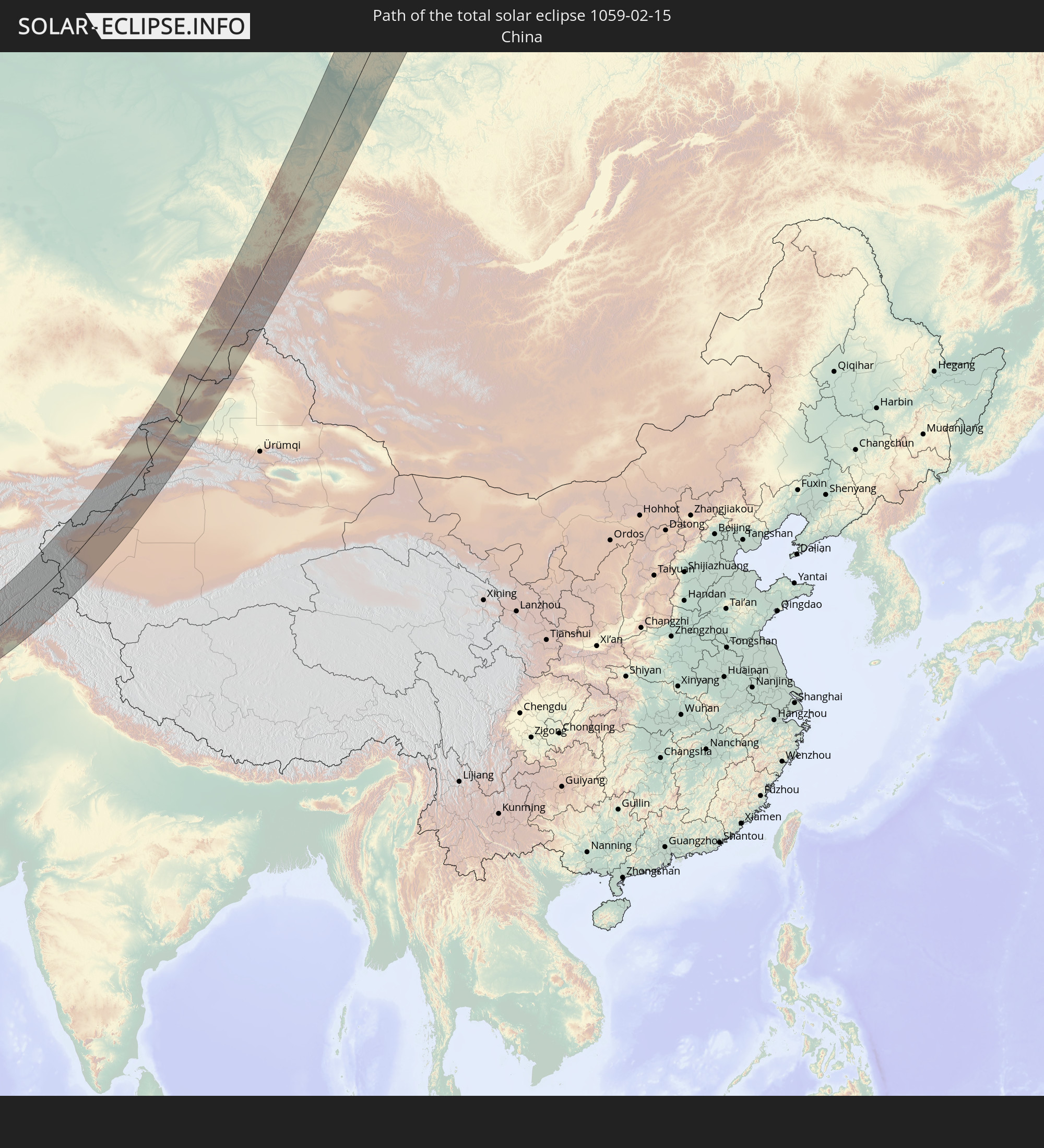
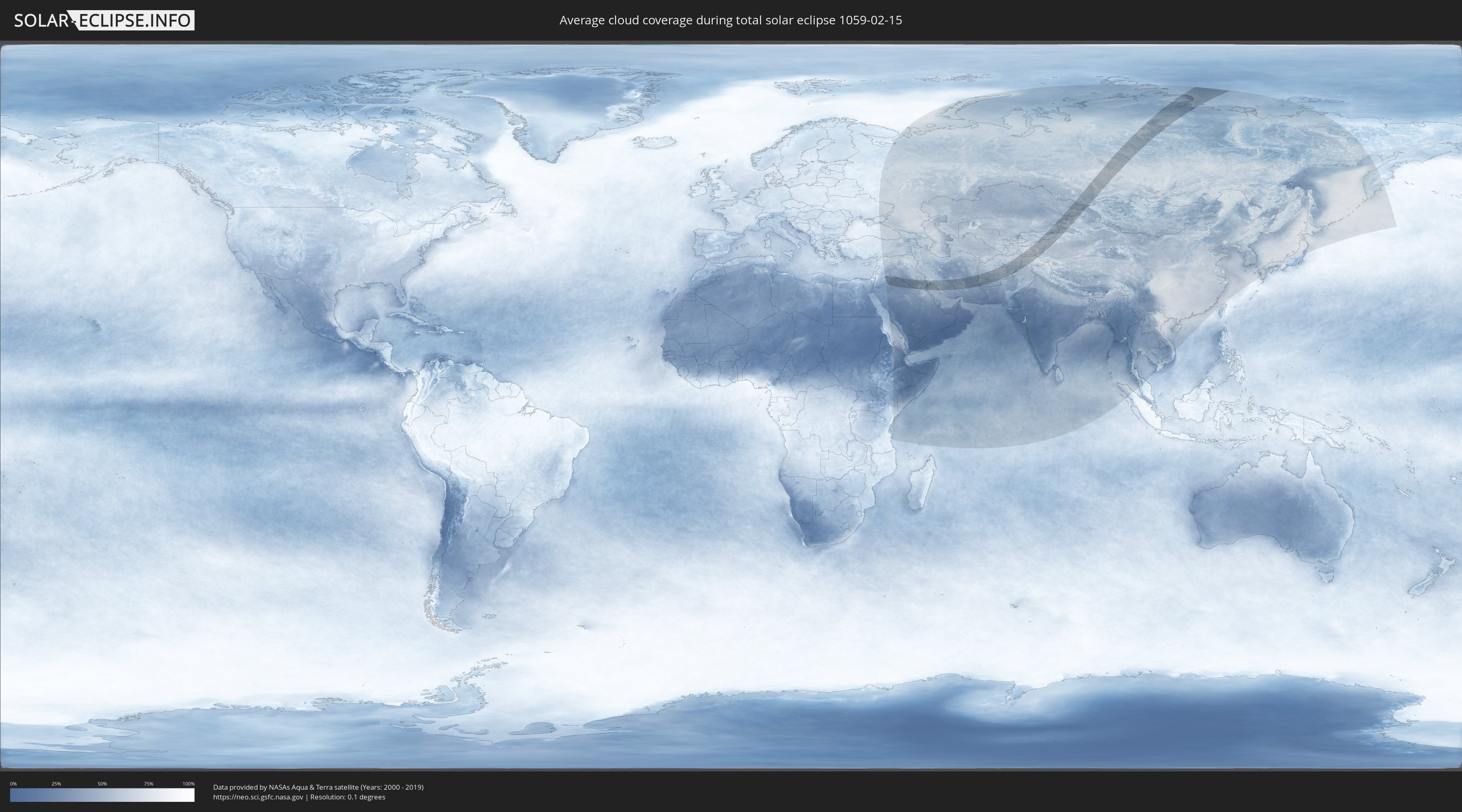
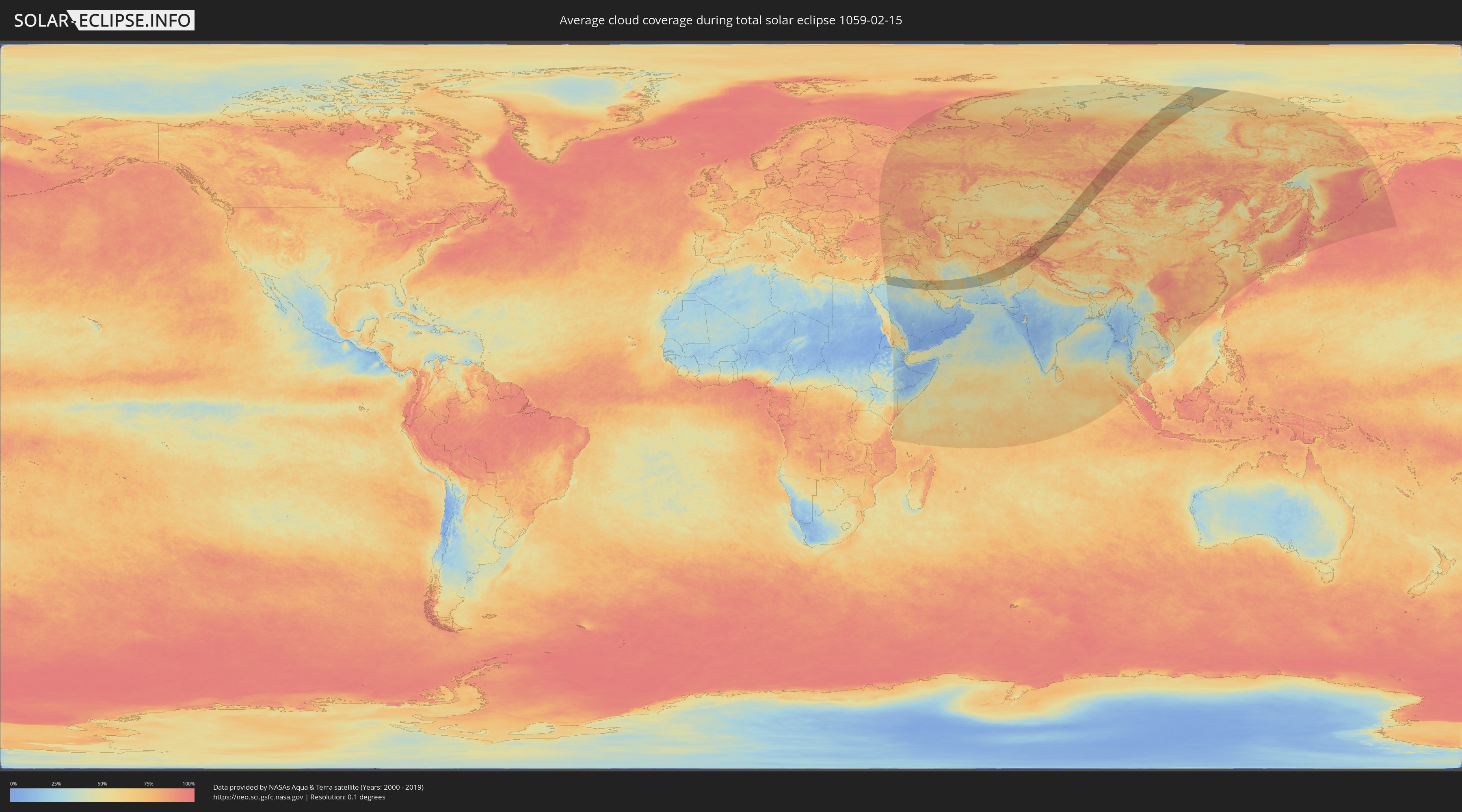
Wie wird das Wetter während der totalen Sonnenfinsternis am 15.02.1059?
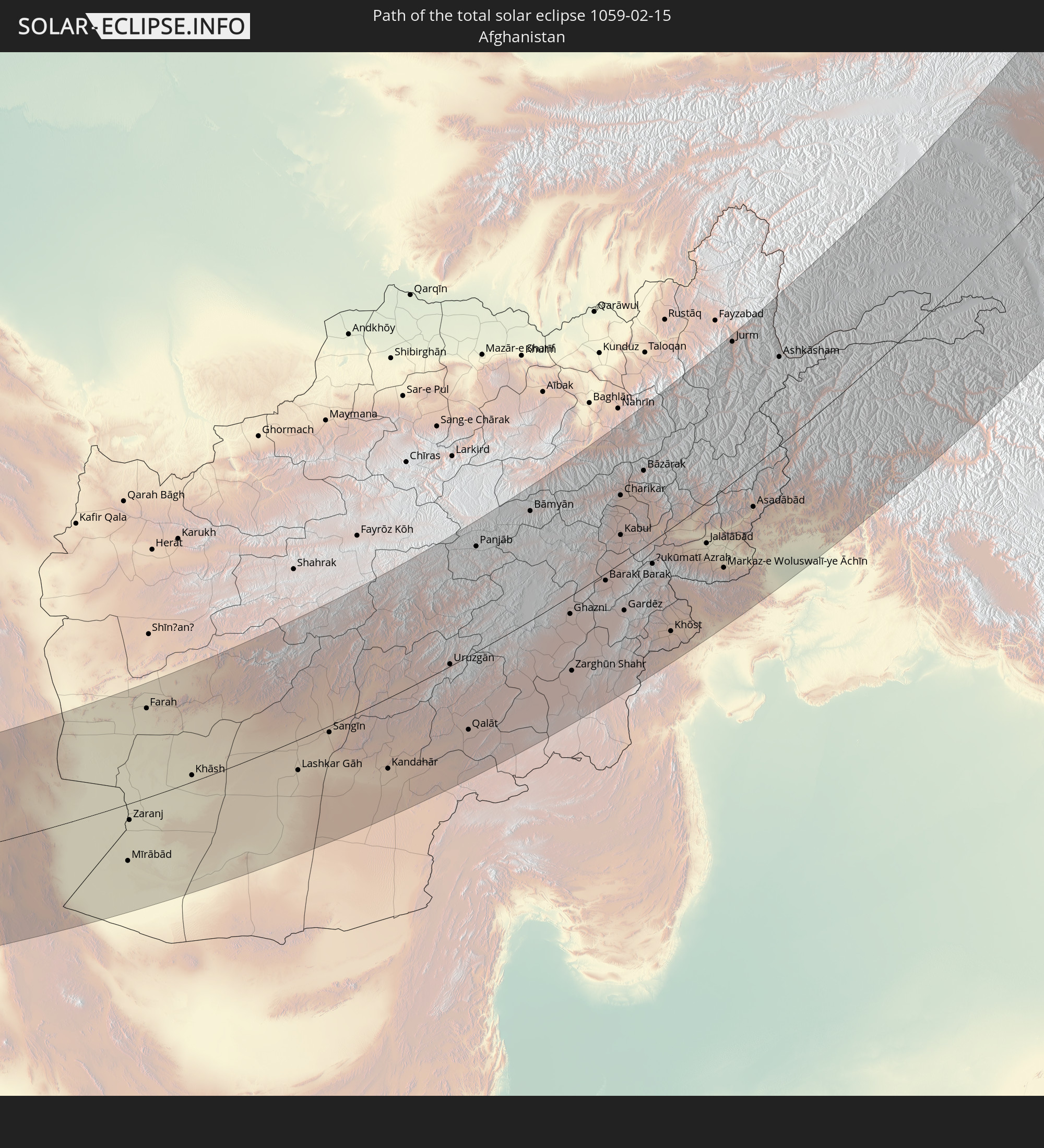
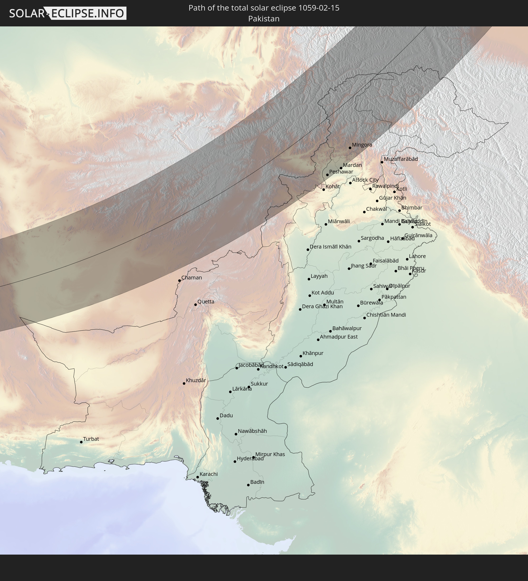
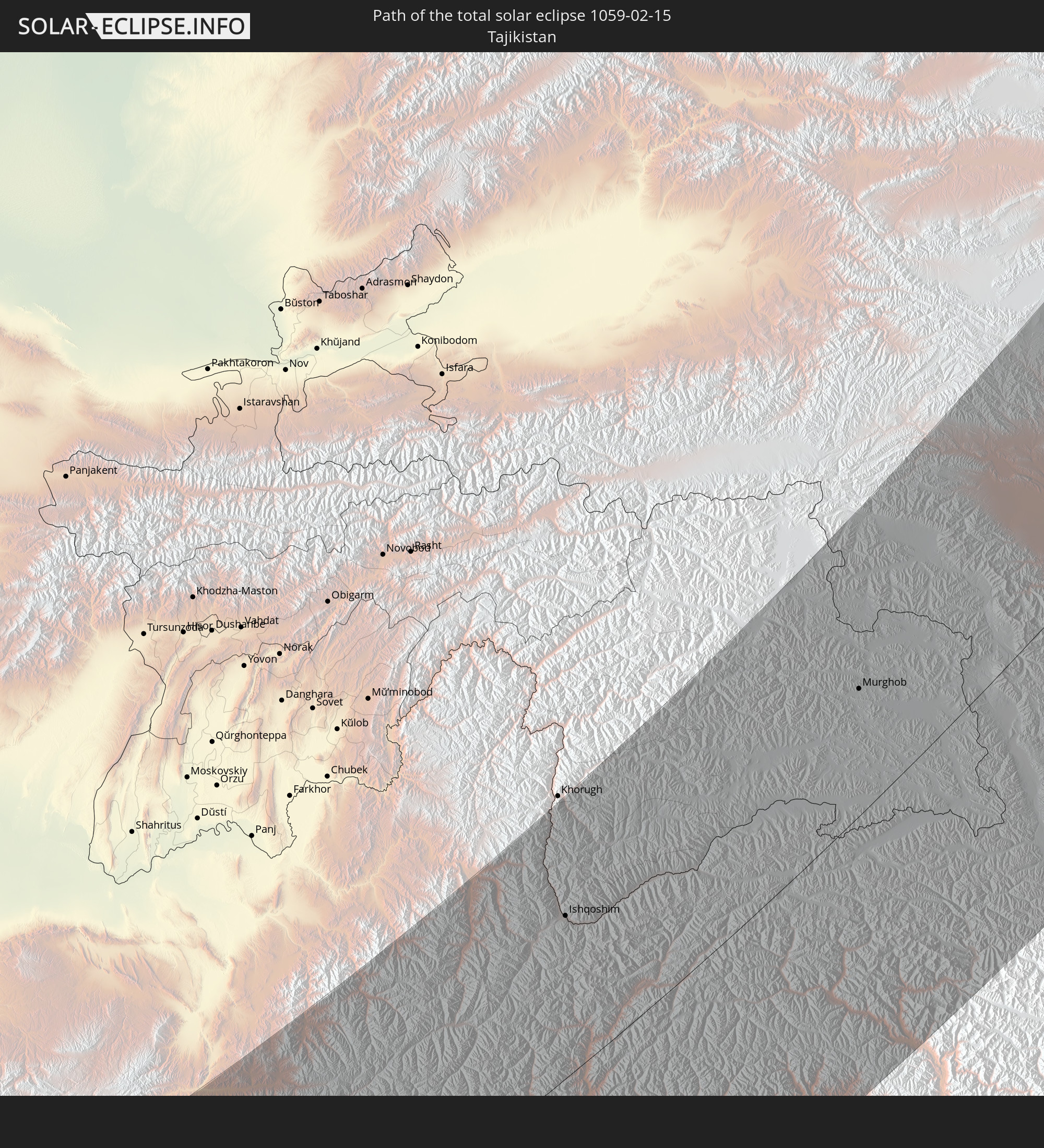
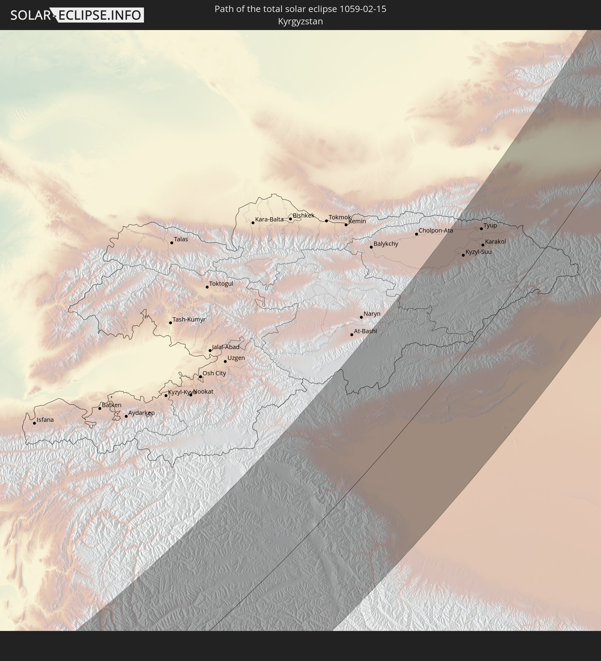
Wo ist der beste Ort, um die totale Sonnenfinsternis vom 15.02.1059 zu beobachten?
Die folgenden Karten zeigen die durchschnittliche Bewölkung für den Tag, an dem die totale Sonnenfinsternis
stattfindet. Mit Hilfe der Karten lässt sich der Ort entlang des Finsternispfades eingrenzen,
der die besten Aussichen auf einen klaren wolkenfreien Himmel bietet.
Trotzdem muss man immer lokale Gegenenheiten beachten und sollte sich genau über das Wetter an seinem
gewählten Beobachtungsort informieren.
Die Daten stammen von den beiden NASA-Satelliten
AQUA und TERRA
und wurden über einen Zeitraum von 19 Jahren (2000 - 2019) gemittelt.
Detaillierte Länderkarten
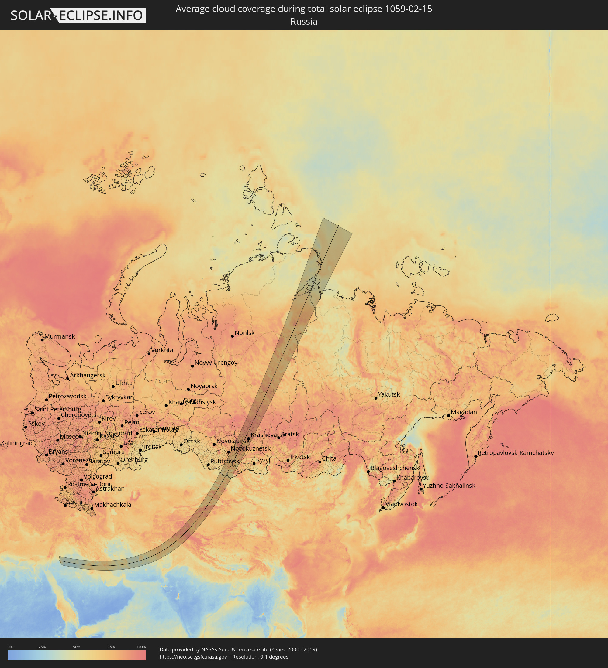 Russland
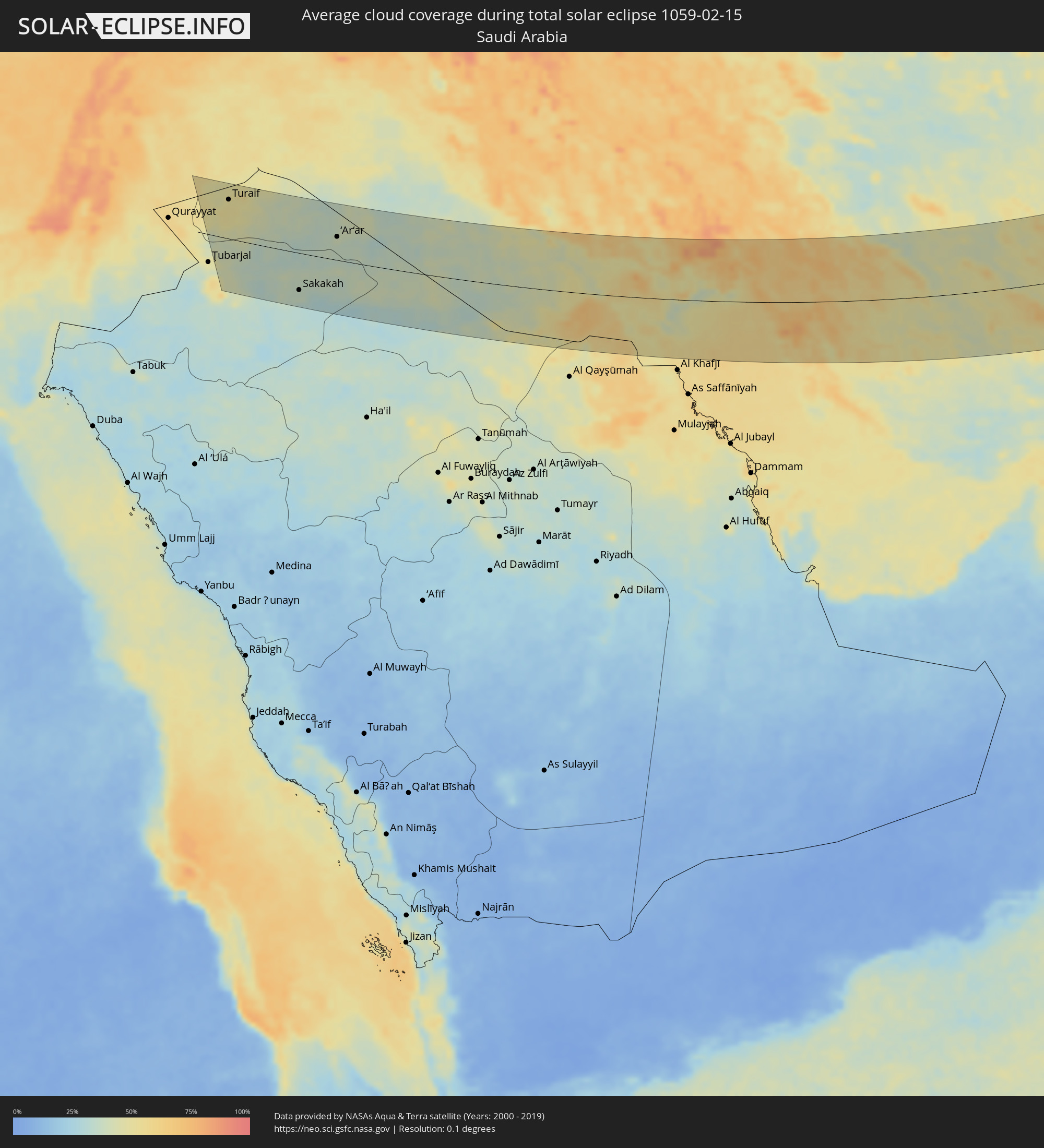 Saudi-Arabien
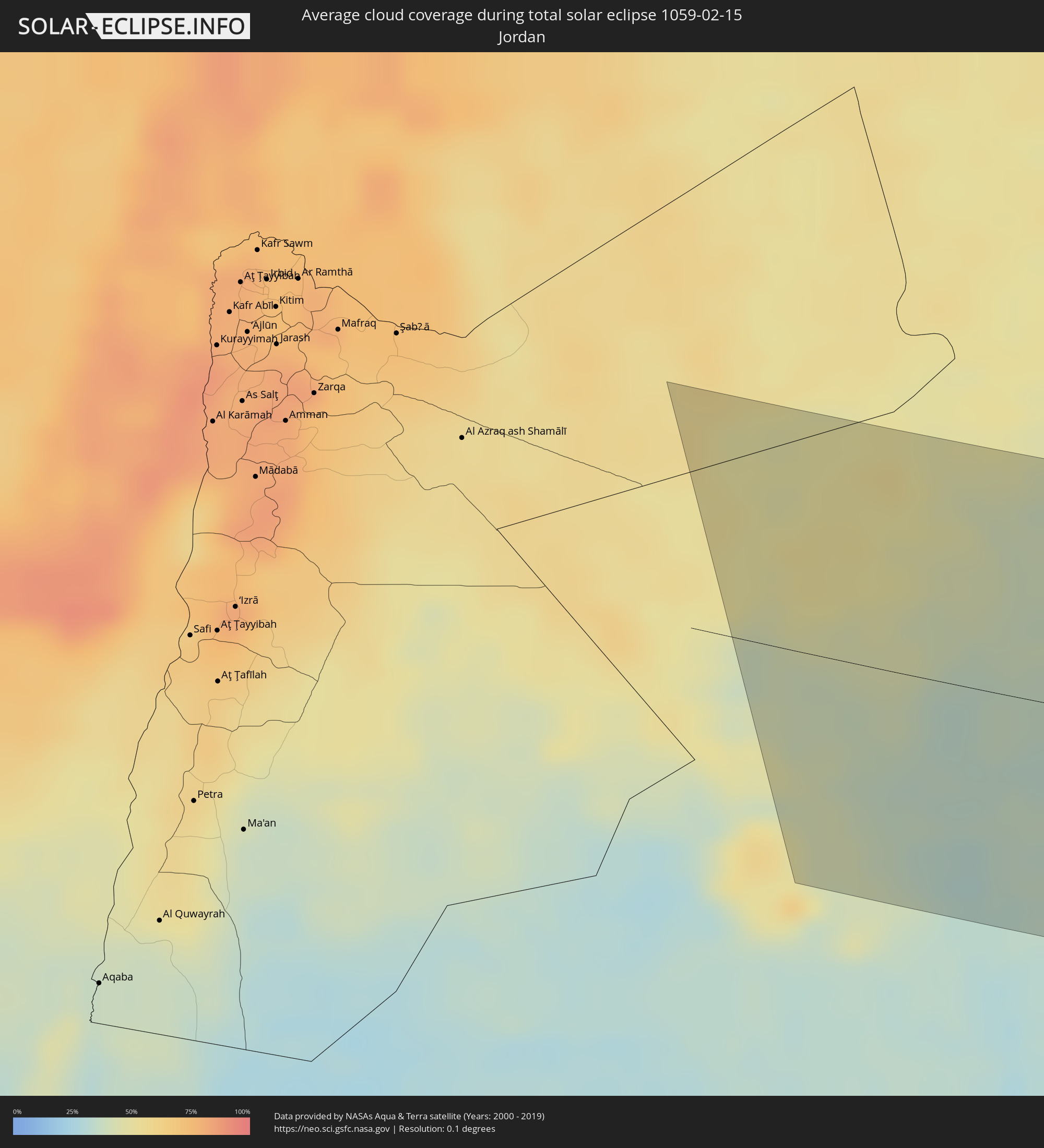 Jordanien
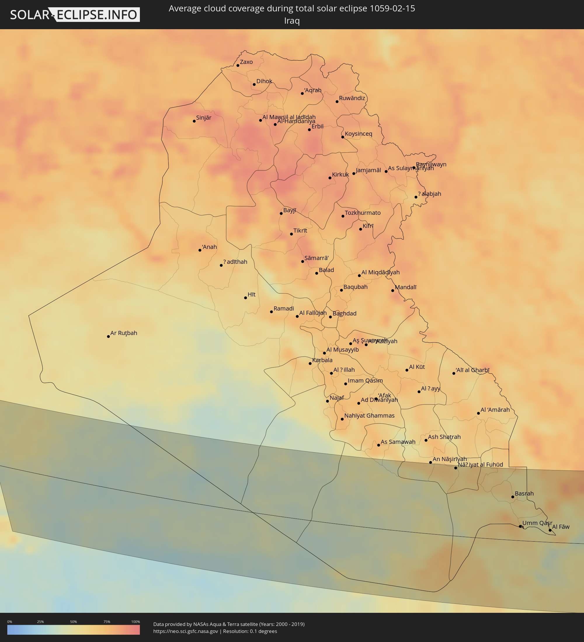 Irak
Irak
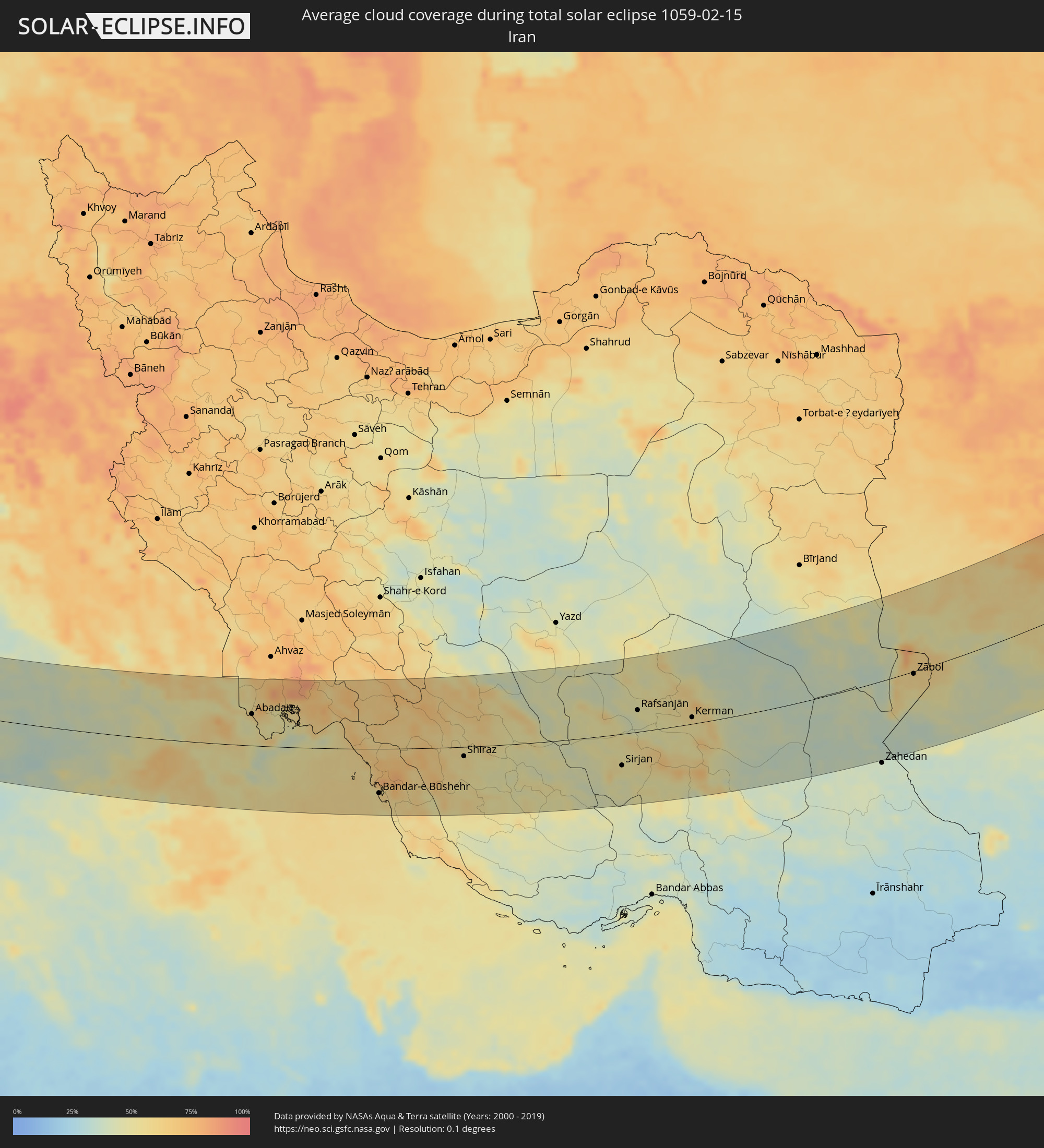 Iran
Iran
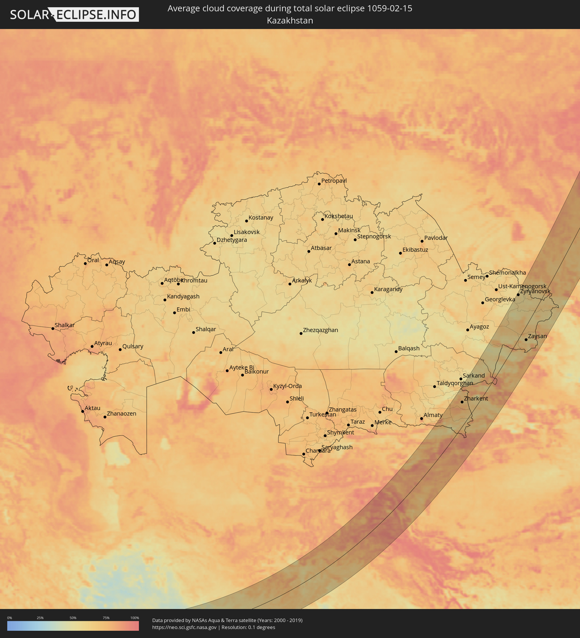 Kasachstan
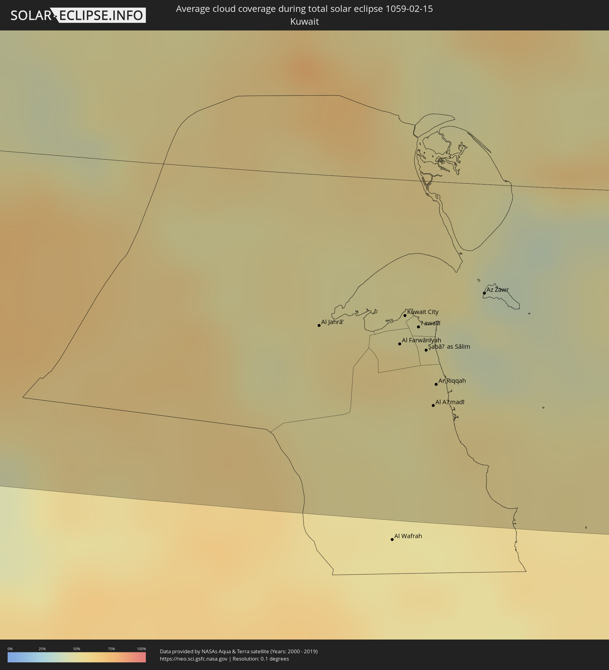 Kuwait
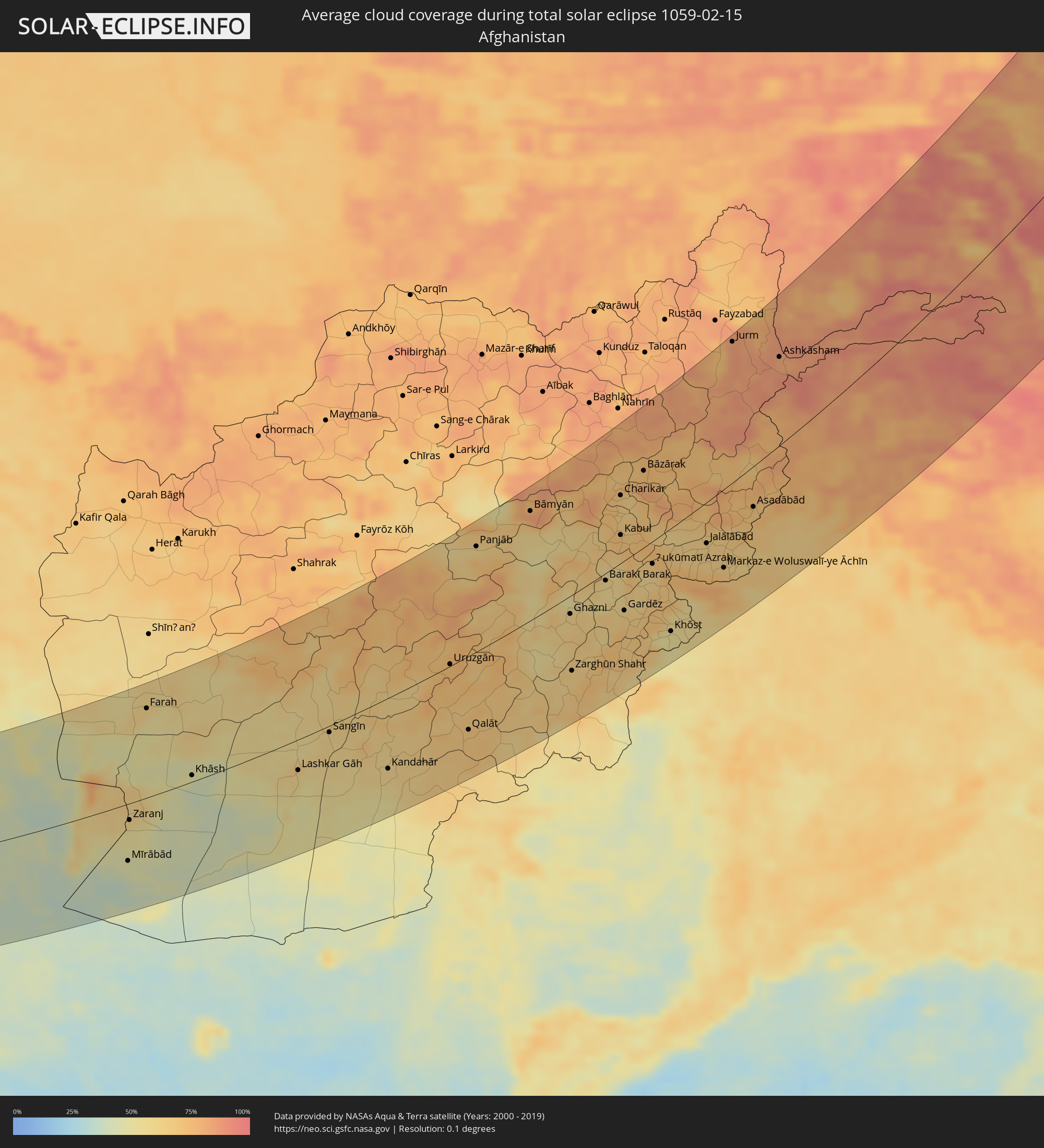 Afghanistan
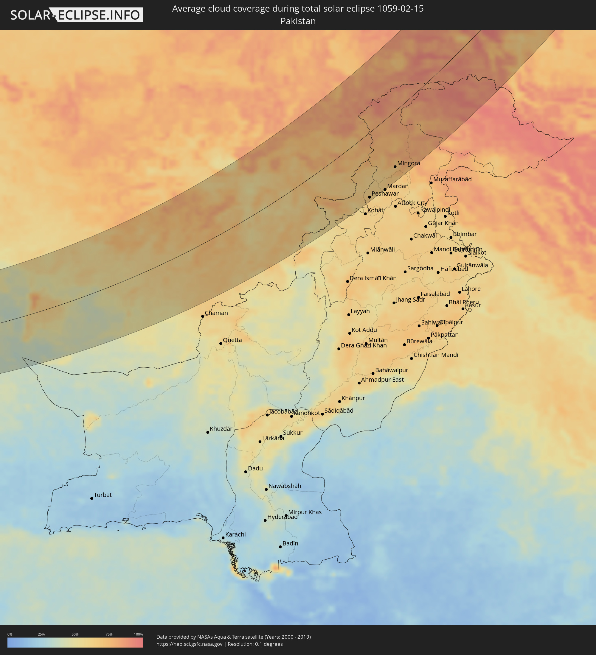 Pakistan
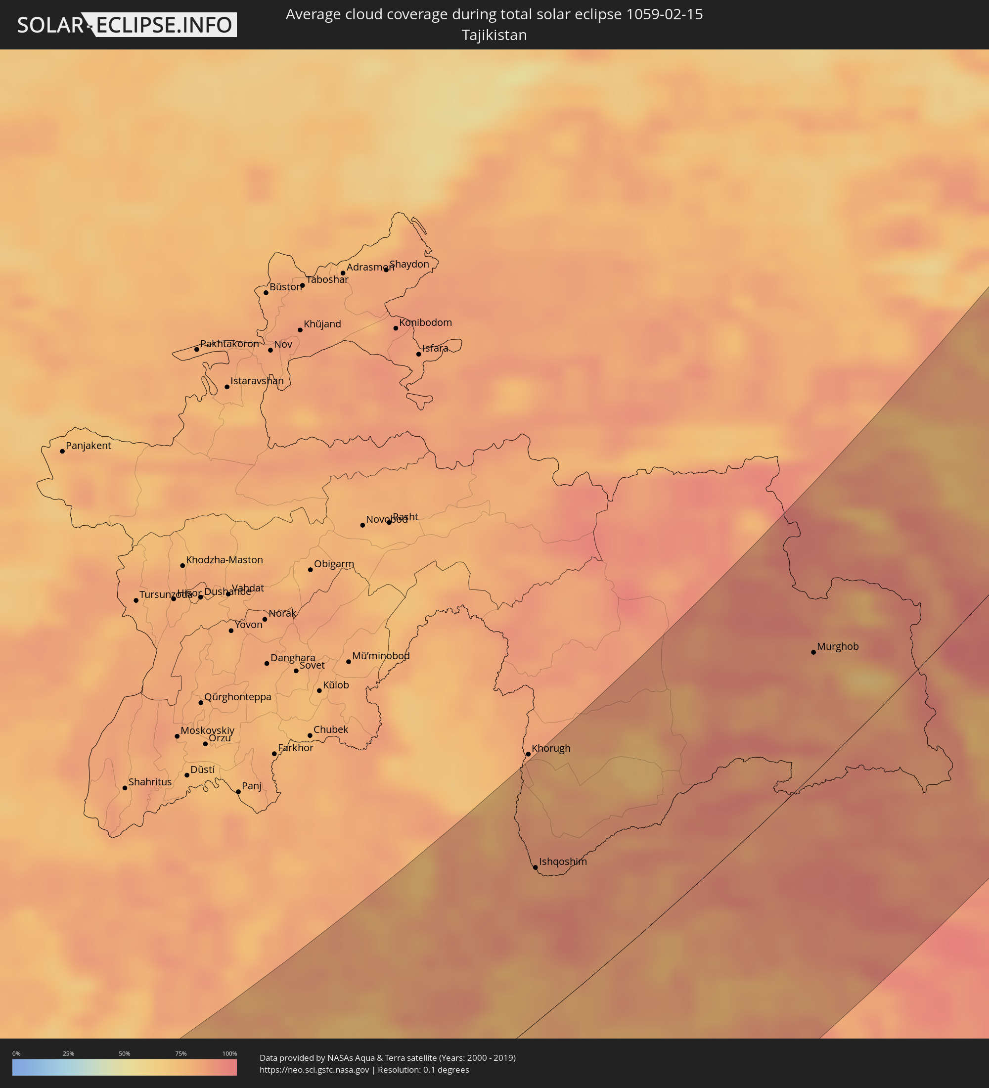 Tadschikistan
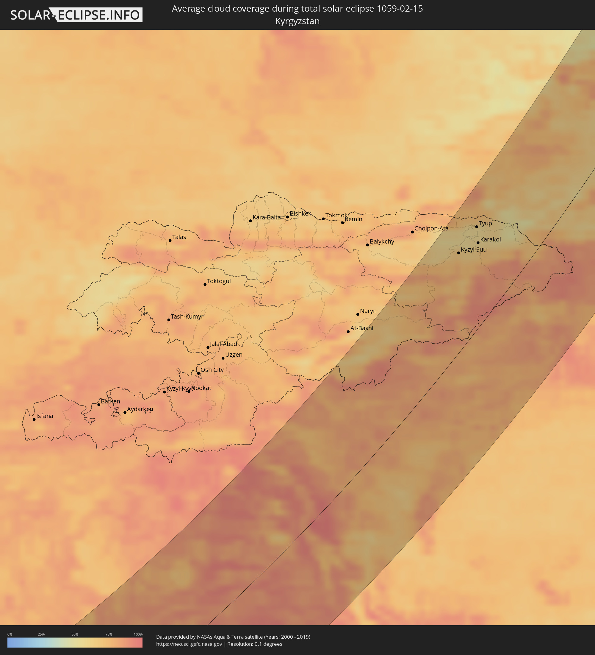 Kirgisistan
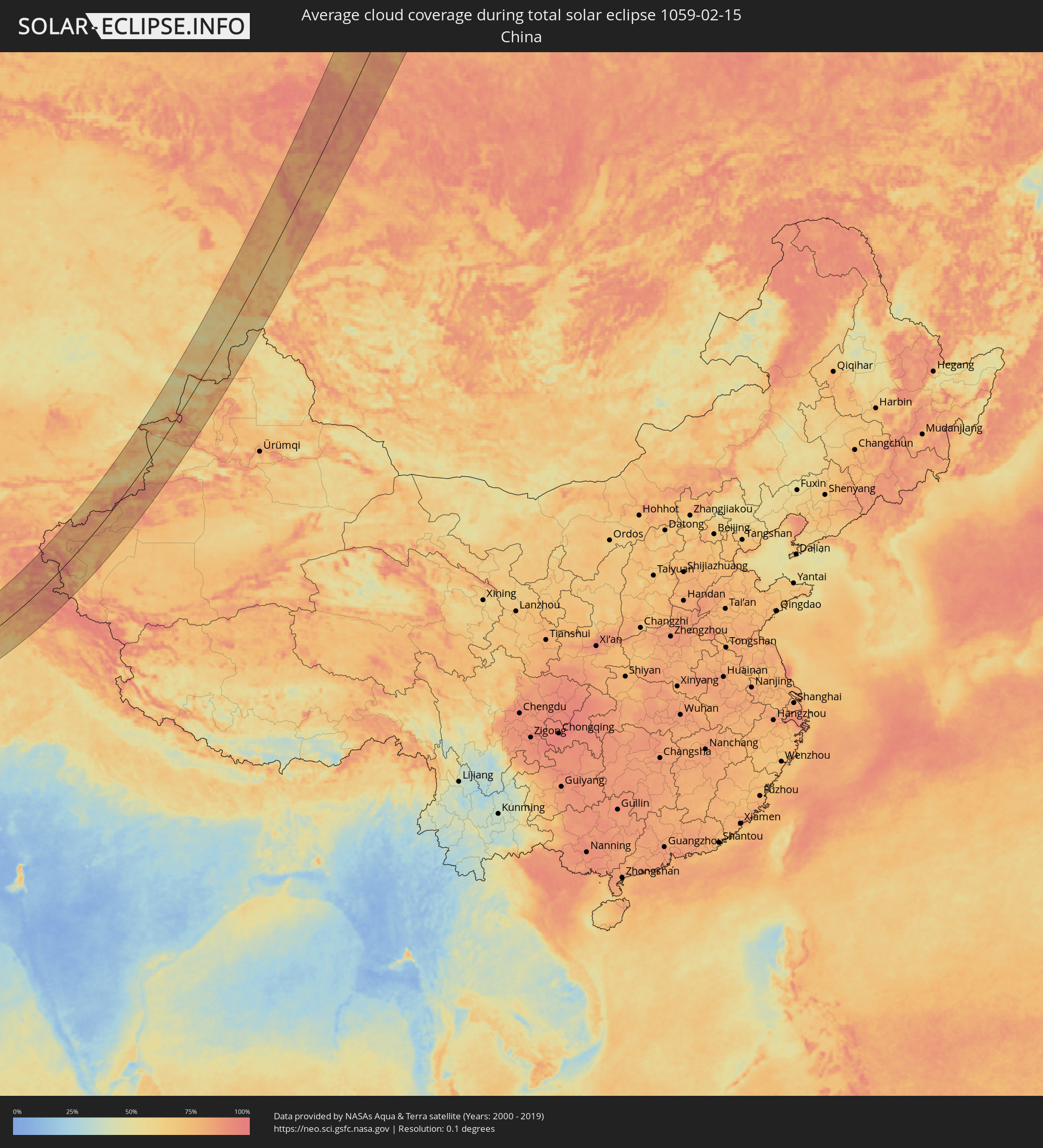 Volksrepublik China
Orte im Finsternispfad
Die nachfolgene Tabelle zeigt Städte und Orte mit mehr als 5.000 Einwohnern, die sich im Finsternispfad befinden. Städte mit mehr als 100.000 Einwohnern sind dick gekennzeichnet. Mit einem Klick auf den Ort öffnet sich eine Detailkarte die die Lage des jeweiligen Ortes zusammen mit dem Verlauf der zentralen Finsternis präsentiert.
| Ort | Typ | Dauer der Verfinsterung | Ortszeit bei maximaler Verfinsterung | Entfernung zur Zentrallinie | Ø Bewölkung |
|
Turaif, Northern Borders
|
total | - | 07:17:37 UTC+03:06 | 80 km | 50% |
|
Sakakah, Al Jawf
|
total | - | 07:15:29 UTC+03:06 | 77 km | 35% |
|
Şuwayr, Al Jawf
|
total | - | 07:15:47 UTC+03:06 | 57 km | 35% |
|
‘Ar‘ar, Northern Borders
|
total | - | 07:17:22 UTC+03:06 | 48 km | 40% |
|
Nāḩiyat al Fuhūd, Dhi Qar
|
total | - | 07:10:53 UTC+02:57 | 120 km | 59% |
|
Al Jahrā’, Al Jahrāʼ
|
total | - | 07:18:03 UTC+03:06 | 54 km | 54% |
|
Az Zubayr, Basra Governorate
|
total | - | 07:10:32 UTC+02:57 | 63 km | 58% |
|
Al Hārithah, Basra Governorate
|
total | - | 07:10:53 UTC+02:57 | 85 km | 60% |
|
Basrah, Basra Governorate
|
total | - | 07:10:46 UTC+02:57 | 76 km | 54% |
|
Al Başrah al Qadīmah, Basra Governorate
|
total | - | 07:10:47 UTC+02:57 | 76 km | 54% |
|
Umm Qaşr, Basra Governorate
|
total | - | 07:10:05 UTC+02:57 | 25 km | 57% |
|
Ar Rābiyah, Al Asimah
|
total | - | 07:18:09 UTC+03:06 | 58 km | 58% |
|
Al Farwānīyah, Al Farwaniyah
|
total | - | 07:18:08 UTC+03:06 | 59 km | 55% |
|
Ash Shāmīyah, Al Asimah
|
total | - | 07:18:15 UTC+03:06 | 52 km | 55% |
|
Janūb as Surrah, Al Farwaniyah
|
total | - | 07:18:08 UTC+03:06 | 60 km | 55% |
|
Kuwait City, Al Asimah
|
total | - | 07:18:18 UTC+03:06 | 49 km | 54% |
|
Ad Dasmah, Al Asimah
|
total | - | 07:18:18 UTC+03:06 | 49 km | 54% |
|
Ḩawallī, Hawalli
|
total | - | 07:18:16 UTC+03:06 | 53 km | 55% |
|
Bayān, Hawalli
|
total | - | 07:18:14 UTC+03:06 | 56 km | 55% |
|
Şabāḩ as Sālim, Mubārak al Kabīr
|
total | - | 07:18:10 UTC+03:06 | 61 km | 53% |
|
Ar Rumaythīyah, Hawalli
|
total | - | 07:18:16 UTC+03:06 | 55 km | 53% |
|
Salwá, Hawalli
|
total | - | 07:18:15 UTC+03:06 | 57 km | 53% |
|
Al Aḩmadī, Al Aḩmadī
|
total | - | 07:17:53 UTC+03:06 | 81 km | 53% |
|
Ar Riqqah, Al Aḩmadī
|
total | - | 07:18:01 UTC+03:06 | 73 km | 53% |
|
Al Finţās, Al Aḩmadī
|
total | - | 07:18:04 UTC+03:06 | 70 km | 52% |
|
Al Faḩāḩīl, Al Aḩmadī
|
total | - | 07:17:56 UTC+03:06 | 80 km | 53% |
|
Al Mahbūlah, Al Aḩmadī
|
total | - | 07:18:02 UTC+03:06 | 73 km | 53% |
|
Al Manqaf, Al Aḩmadī
|
total | - | 07:17:57 UTC+03:06 | 79 km | 53% |
|
Khorramshahr, Khuzestan
|
total | - | 07:39:03 UTC+03:25 | 71 km | 59% |
|
Az Zawr, Al Asimah
|
total | - | 07:18:36 UTC+03:06 | 39 km | 41% |
|
Abadan, Khuzestan
|
total | - | 07:38:57 UTC+03:25 | 60 km | 54% |
|
Al Fāw, Basra Governorate
|
total | - | 07:10:20 UTC+02:57 | 21 km | 60% |
|
Behbahān, Khuzestan
|
total | - | 07:40:41 UTC+03:25 | 95 km | 71% |
|
Dehdasht, Kohgīlūyeh va Būyer Aḩmad
|
total | - | 07:41:15 UTC+03:25 | 117 km | 62% |
|
Dogonbadan, Kohgīlūyeh va Būyer Aḩmad
|
total | - | 07:40:41 UTC+03:25 | 69 km | 66% |
|
Bandar-e Būshehr, Bushehr
|
total | - | 07:38:25 UTC+03:25 | 86 km | 59% |
|
Borāzjān, Bushehr
|
total | - | 07:39:11 UTC+03:25 | 53 km | 77% |
|
Nūrābād, Fars
|
total | - | 07:40:49 UTC+03:25 | 41 km | 69% |
|
Yasuj, Kohgīlūyeh va Būyer Aḩmad
|
total | - | 07:41:48 UTC+03:25 | 102 km | 70% |
|
Kāzerūn, Fars
|
total | - | 07:40:06 UTC+03:25 | 14 km | 72% |
|
Shiraz, Fars
|
total | - | 07:40:45 UTC+03:25 | 18 km | 56% |
|
Fīrūzābād, Fars
|
total | - | 07:39:30 UTC+03:25 | 103 km | 57% |
|
Akbarābād, Fars
|
total | - | 07:40:20 UTC+03:25 | 60 km | 50% |
|
Fasā, Fars
|
total | - | 07:40:31 UTC+03:25 | 99 km | 49% |
|
Sirjan, Kerman
|
total | - | 07:43:08 UTC+03:25 | 60 km | 51% |
|
Rafsanjān, Kerman
|
total | - | 07:45:02 UTC+03:25 | 41 km | 49% |
|
Kerman, Kerman
|
total | - | 07:45:51 UTC+03:25 | 12 km | 57% |
|
Bam, Kerman
|
total | - | 07:45:04 UTC+03:25 | 139 km | 39% |
|
Zābol, Sistan and Baluchestan
|
total | - | 07:51:43 UTC+03:25 | 4 km | 58% |
|
Zaranj, Nimroz
|
total | - | 08:26:16 UTC+04:00 | 22 km | 59% |
|
Farah, Farah
|
total | - | 08:29:02 UTC+04:00 | 119 km | 59% |
|
Khāsh, Nimroz
|
total | - | 08:28:19 UTC+04:00 | 9 km | 44% |
|
Lashkar Gāh, Helmand
|
total | - | 08:30:19 UTC+04:00 | 40 km | 59% |
|
Gereshk, Helmand
|
total | - | 08:30:57 UTC+04:00 | 24 km | 58% |
|
Kandahār, Kandahar
|
total | - | 08:32:00 UTC+04:00 | 89 km | 59% |
|
Bāmyān, Bamyan
|
total | - | 08:40:22 UTC+04:00 | 127 km | 77% |
|
Ghazni, Ghazni
|
total | - | 08:38:55 UTC+04:00 | 21 km | 61% |
|
Barakī Barak, Logar
|
total | - | 08:40:21 UTC+04:00 | 9 km | 59% |
|
Paghmān, Kabul
|
total | - | 08:41:26 UTC+04:00 | 49 km | 68% |
|
Charikar, Parwan
|
total | - | 08:42:29 UTC+04:00 | 76 km | 66% |
|
Kabul, Kabul
|
total | - | 08:41:38 UTC+04:00 | 32 km | 70% |
|
Gardēz, Paktia
|
total | - | 08:40:04 UTC+04:00 | 57 km | 64% |
|
Bāzārak, Panjshir
|
total | - | 08:43:28 UTC+04:00 | 85 km | 74% |
|
Khōst, Khowst
|
total | - | 08:40:34 UTC+04:00 | 116 km | 53% |
|
Parachinar, Federally Administered Tribal Areas
|
total | - | 09:10:00 UTC+04:28 | 74 km | 58% |
|
Mehtar Lām, Laghman
|
total | - | 08:43:17 UTC+04:00 | 10 km | 67% |
|
Jalālābād, Nangarhar
|
total | - | 08:43:12 UTC+04:00 | 45 km | 65% |
|
Doāba, Khyber Pakhtunkhwa
|
total | - | 09:10:02 UTC+04:28 | 151 km | 59% |
|
Asadābād, Kunar
|
total | - | 08:44:56 UTC+04:00 | 43 km | 69% |
|
Āsmār, Kunar
|
total | - | 08:45:30 UTC+04:00 | 41 km | 74% |
|
Shabqadar, Khyber Pakhtunkhwa
|
total | - | 09:12:34 UTC+04:28 | 124 km | 63% |
|
Peshawar, Khyber Pakhtunkhwa
|
total | - | 09:12:14 UTC+04:28 | 144 km | 65% |
|
Ishqoshim, Gorno-Badakhshan
|
total | - | 09:23:59 UTC+04:35 | 90 km | 81% |
|
Tangi, Khyber Pakhtunkhwa
|
total | - | 09:12:51 UTC+04:28 | 122 km | 62% |
|
Chārsadda, Khyber Pakhtunkhwa
|
total | - | 09:12:42 UTC+04:28 | 141 km | 61% |
|
Utmānzai, Khyber Pakhtunkhwa
|
total | - | 09:12:48 UTC+04:28 | 138 km | 62% |
|
Upper Dir, Khyber Pakhtunkhwa
|
total | - | 09:14:44 UTC+04:28 | 55 km | 74% |
|
Bat Khela, Khyber Pakhtunkhwa
|
total | - | 09:13:51 UTC+04:28 | 112 km | 63% |
|
Tāl, Khyber Pakhtunkhwa
|
total | - | 09:15:43 UTC+04:28 | 53 km | 76% |
|
Mingora, Khyber Pakhtunkhwa
|
total | - | 09:14:41 UTC+04:28 | 120 km | 70% |
|
Murghob, Gorno-Badakhshan
|
total | - | 09:29:43 UTC+04:35 | 64 km | 82% |
|
Gilgit, Gilgit-Baltistan
|
total | - | 09:19:26 UTC+04:28 | 138 km | 83% |
|
Kashgar, Xinjiang Uyghur Autonomous Region
|
total | - | 12:59:32 UTC+08:00 | 33 km | 84% |
|
Shache, Xinjiang Uyghur Autonomous Region
|
total | - | 12:59:38 UTC+08:00 | 126 km | 85% |
|
Kyzyl-Suu, Issyk-Kul Region
|
total | - | 10:05:17 UTC+04:58 | 100 km | 73% |
|
Tyup, Issyk-Kul Region
|
total | - | 10:06:22 UTC+04:58 | 102 km | 56% |
|
Karakol, Issyk-Kul Region
|
total | - | 10:06:03 UTC+04:58 | 84 km | 59% |
|
Ak-Suu, Issyk-Kul Region
|
total | - | 10:06:15 UTC+04:58 | 76 km | 60% |
|
Kegen, Almaty Oblysy
|
total | - | 09:31:28 UTC+04:21 | 64 km | 56% |
|
Zharkent, Almaty Oblysy
|
total | - | 09:34:13 UTC+04:21 | 84 km | 71% |
|
Aykol, Xinjiang Uyghur Autonomous Region
|
total | - | 13:07:50 UTC+08:00 | 134 km | 86% |
|
Aksu, Xinjiang Uyghur Autonomous Region
|
total | - | 13:08:23 UTC+08:00 | 128 km | 83% |
|
Kurchum, East Kazakhstan
|
total | - | 09:44:53 UTC+04:21 | 98 km | 59% |
|
Aksuat
|
total | - | 09:45:07 UTC+04:21 | 104 km | 57% |
|
Tūghyl, East Kazakhstan
|
total | - | 09:44:35 UTC+04:21 | 17 km | 57% |
|
Zyryanovsk, East Kazakhstan
|
total | - | 09:47:02 UTC+04:21 | 122 km | 59% |
|
Zaysan, East Kazakhstan
|
total | - | 09:45:09 UTC+04:21 | 41 km | 54% |
|
Myski, Kemerovo
|
total | - | 11:44:57 UTC+06:11 | 106 km | 82% |
|
Tashtagol, Kemerovo
|
total | - | 11:44:10 UTC+06:11 | 54 km | 73% |
|
Mezhdurechensk, Kemerovo
|
total | - | 11:45:14 UTC+06:11 | 90 km | 78% |
|
Sharypovo, Krasnoyarskiy
|
total | - | 11:48:05 UTC+06:11 | 113 km | 81% |
|
Uzhur, Krasnoyarskiy
|
total | - | 11:48:35 UTC+06:11 | 66 km | 81% |
|
Abaza, Khakasiya
|
total | - | 11:46:40 UTC+06:11 | 83 km | 85% |
|
Sorsk, Khakasiya
|
total | - | 11:47:59 UTC+06:11 | 23 km | 81% |
|
Nazarovo, Krasnoyarskiy
|
total | - | 11:49:45 UTC+06:11 | 67 km | 82% |
|
Achinsk, Krasnoyarskiy
|
total | - | 11:50:02 UTC+06:11 | 74 km | 88% |
|
Chernogorsk, Khakasiya
|
total | - | 11:49:01 UTC+06:11 | 92 km | 86% |
|
Abakan, Khakasiya
|
total | - | 11:49:06 UTC+06:11 | 106 km | 88% |
|
Yeniseysk, Krasnoyarskiy
|
total | - | 11:53:15 UTC+06:11 | 84 km | 89% |
|
Divnogorsk, Krasnoyarskiy
|
total | - | 11:51:49 UTC+06:11 | 46 km | 86% |
|
Lesosibirsk, Krasnoyarskiy
|
total | - | 11:53:25 UTC+06:11 | 58 km | 87% |
|
Yemel’yanovo, Krasnoyarskiy
|
total | - | 11:52:17 UTC+06:11 | 52 km | 83% |
|
Krasnoyarsk, Krasnoyarskiy
|
total | - | 11:52:23 UTC+06:11 | 70 km | 87% |
|
Berëzovka, Krasnoyarskiy
|
total | - | 11:52:39 UTC+06:11 | 83 km | 85% |
|
Sosnovoborsk, Krasnoyarskiy
|
total | - | 11:52:58 UTC+06:11 | 91 km | 87% |
|
Zheleznogorsk, Krasnoyarskiy
|
total | - | 11:53:15 UTC+06:11 | 95 km | 88% |