Totale Sonnenfinsternis vom 01.07.1079
| Wochentag: | Dienstag |
| Maximale Dauer der Verfinsterung: | 05m12s |
| Maximale Breite des Finsternispfades: | 230 km |
| Saroszyklus: | 102 |
| Bedeckungsgrad: | 100% |
| Magnitude: | 1.0663 |
| Gamma: | 0.3381 |
Wo kann man die Sonnenfinsternis vom 01.07.1079 sehen?
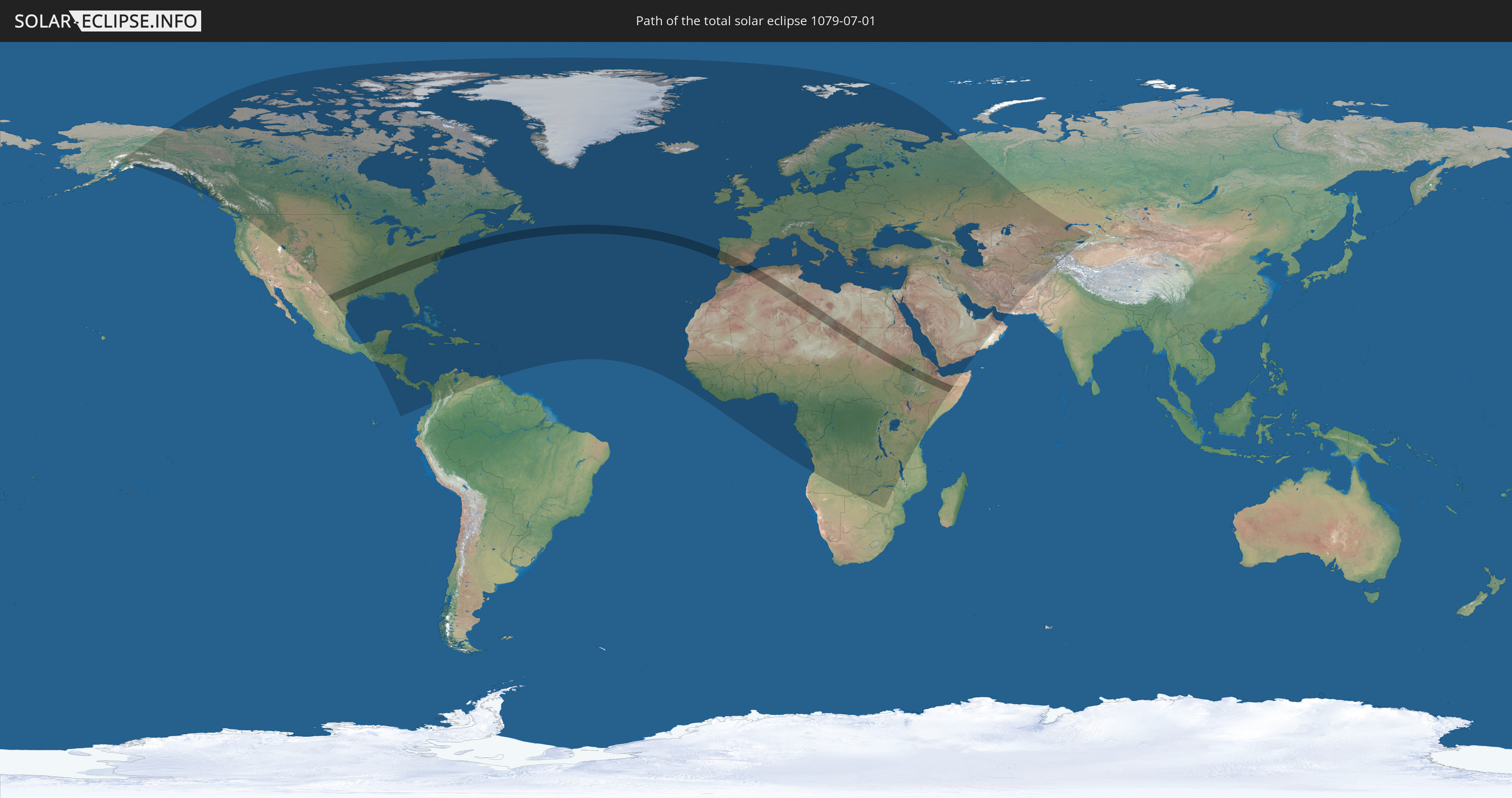
Die Sonnenfinsternis am 01.07.1079 kann man in 165 Ländern als partielle Sonnenfinsternis beobachten.
Der Finsternispfad verläuft durch 11 Länder. Nur in diesen Ländern ist sie als totale Sonnenfinsternis zu sehen.
In den folgenden Ländern ist die Sonnenfinsternis total zu sehen
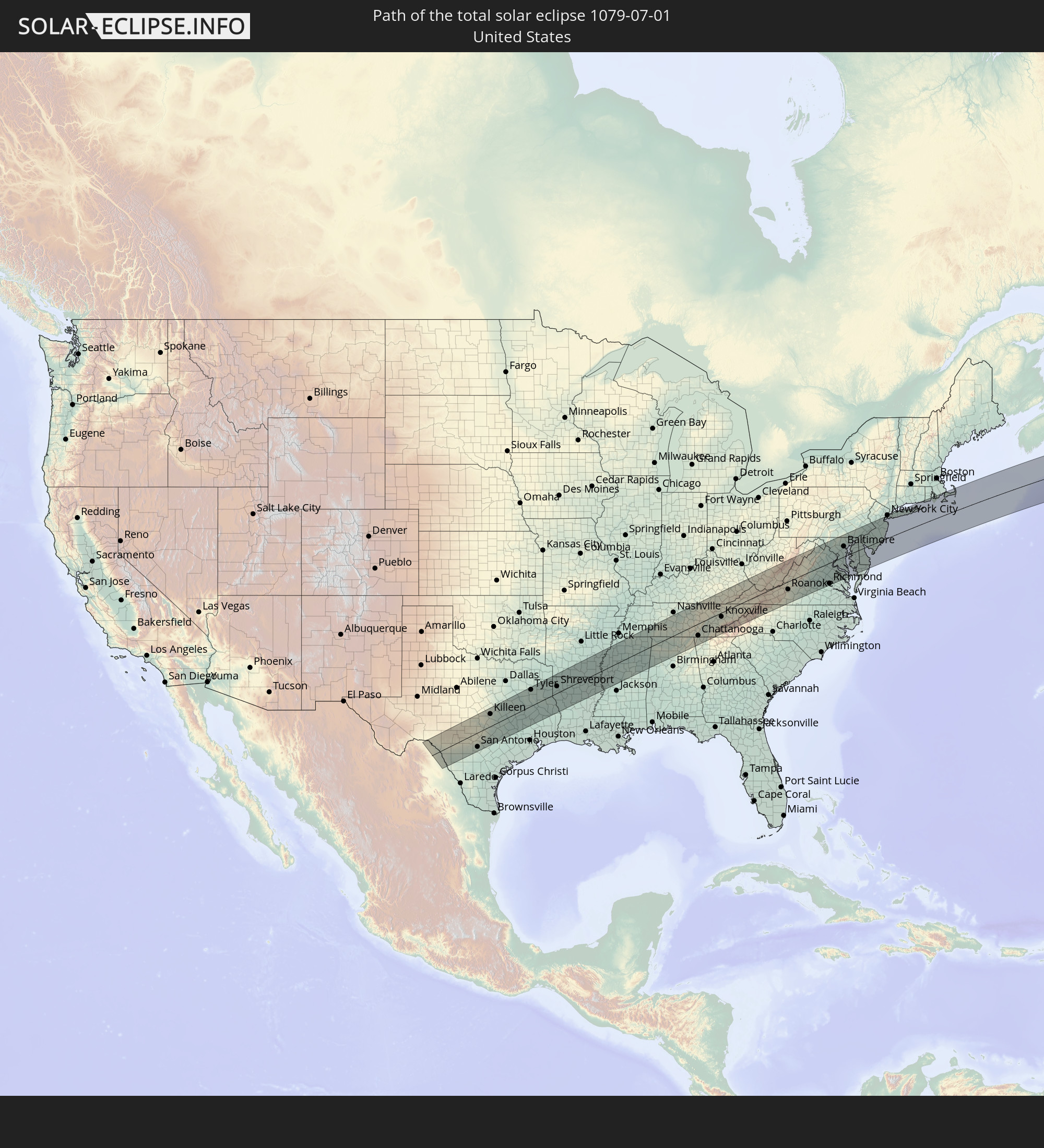 Vereinigte Staaten
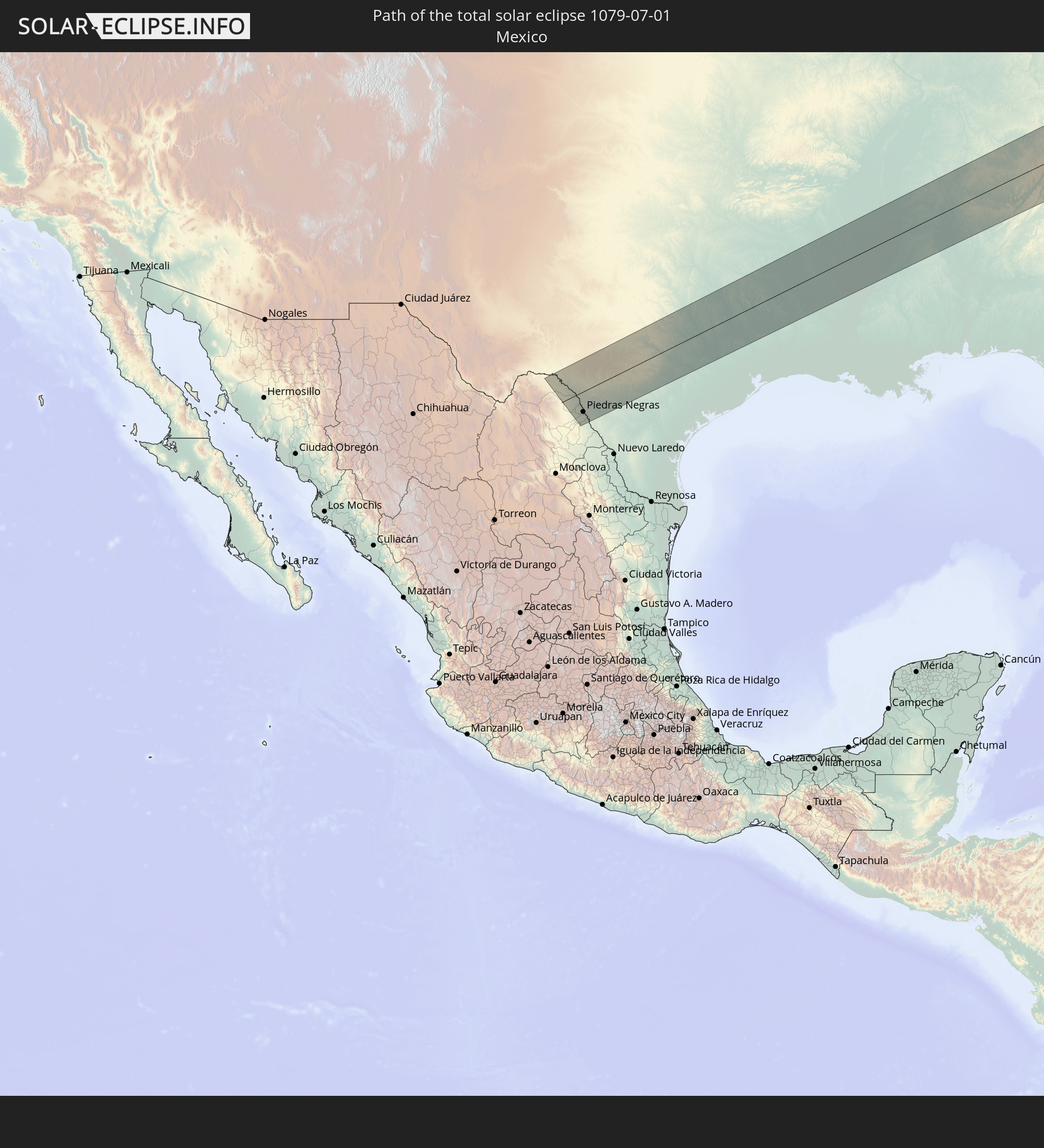 Mexiko
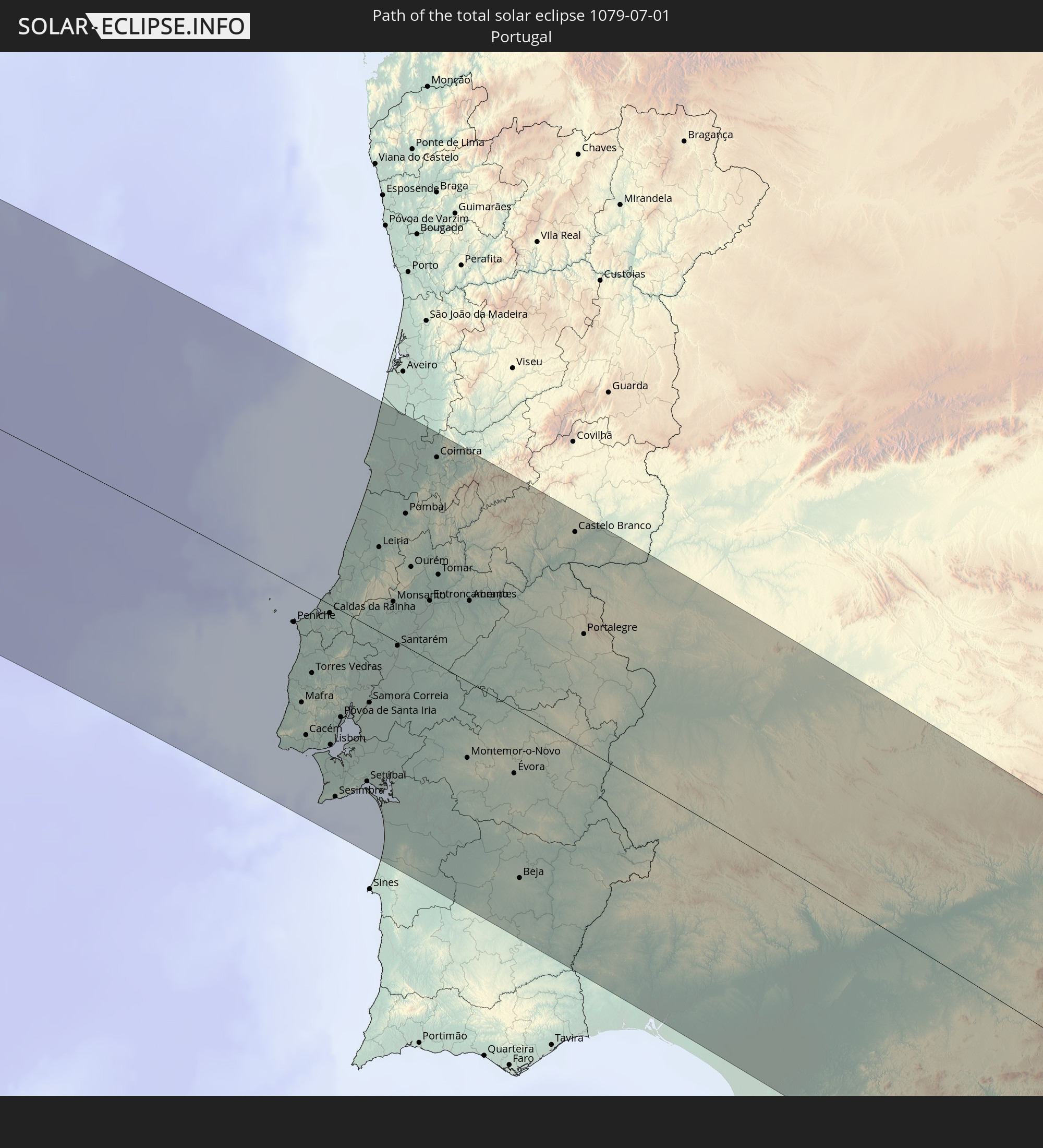 Portugal
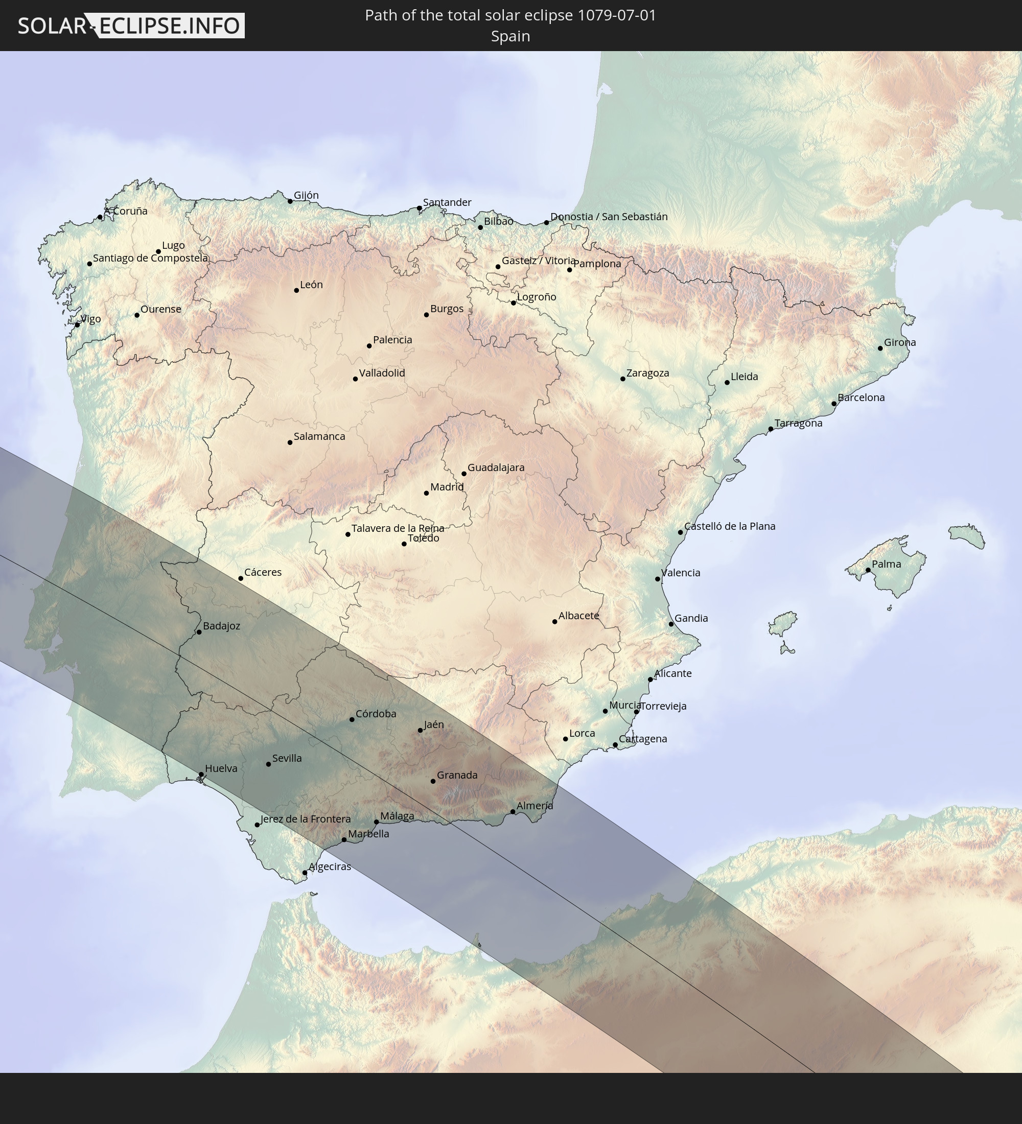 Spanien
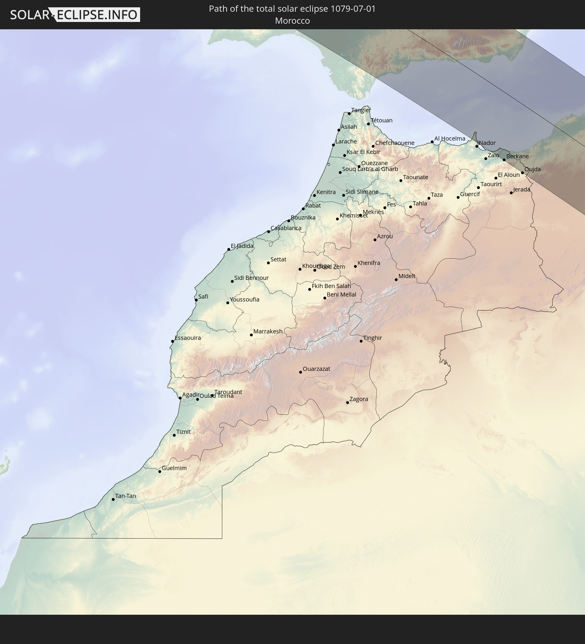 Marokko
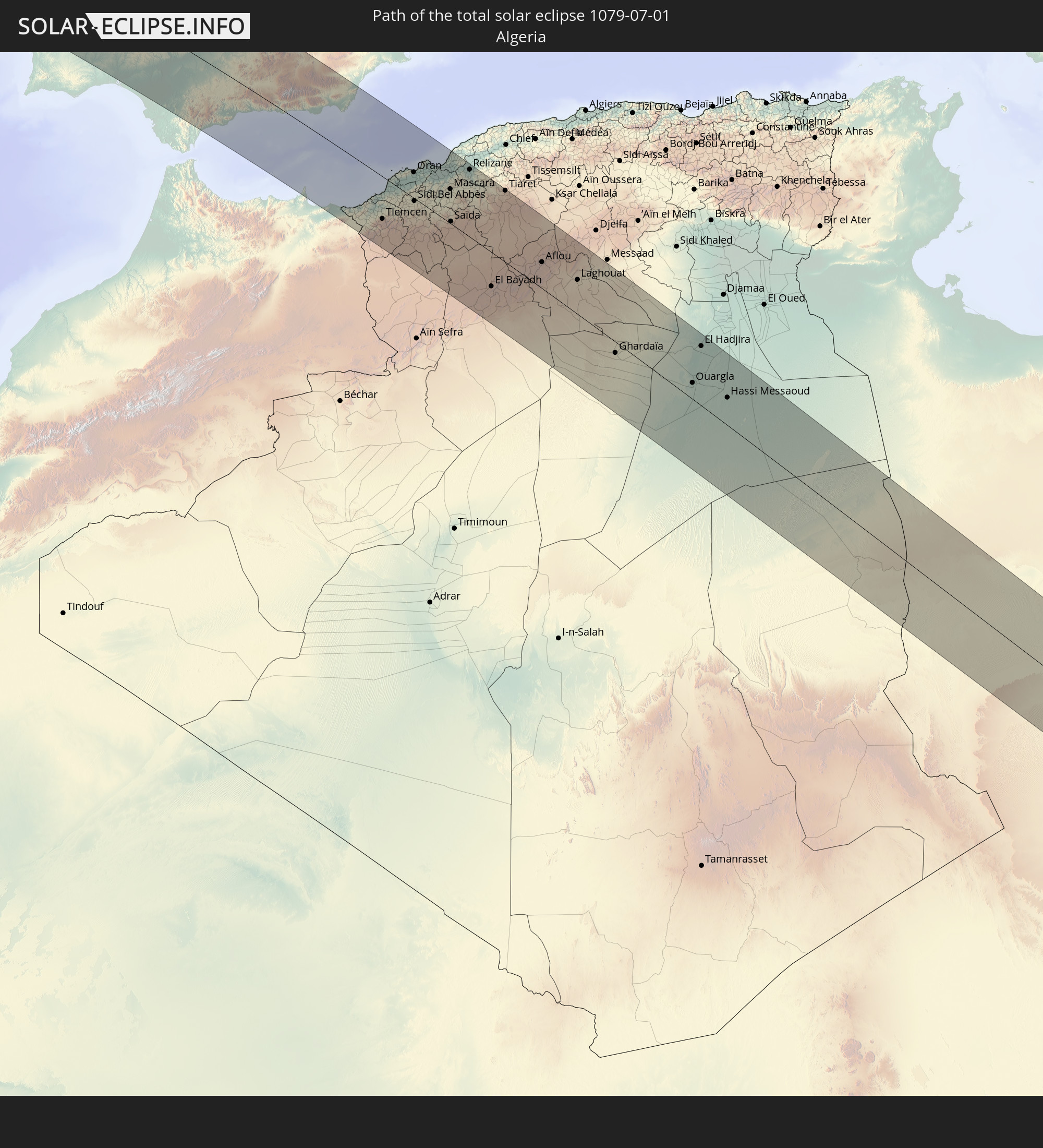 Algerien
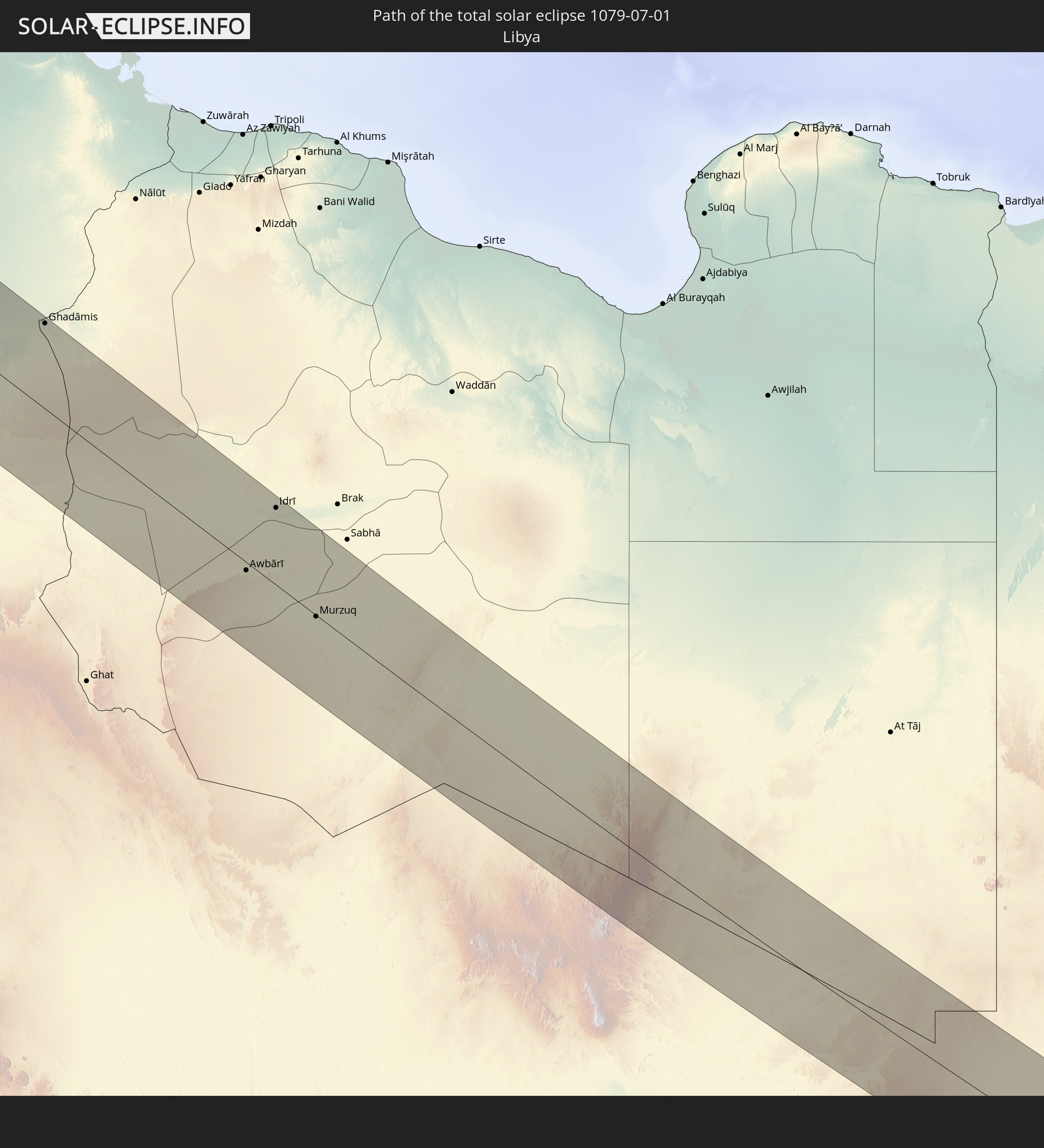 Libyen
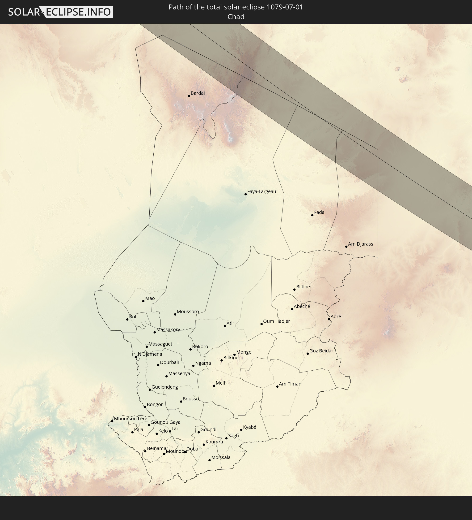 Tschad
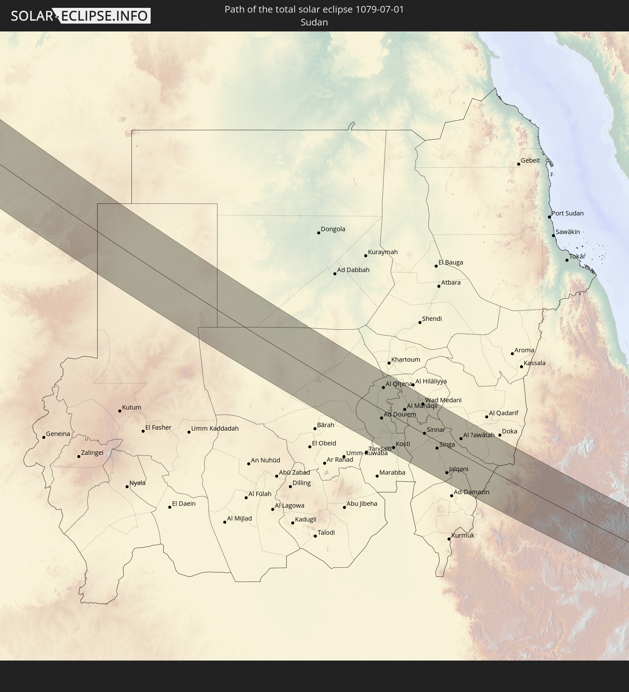 Sudan
Sudan
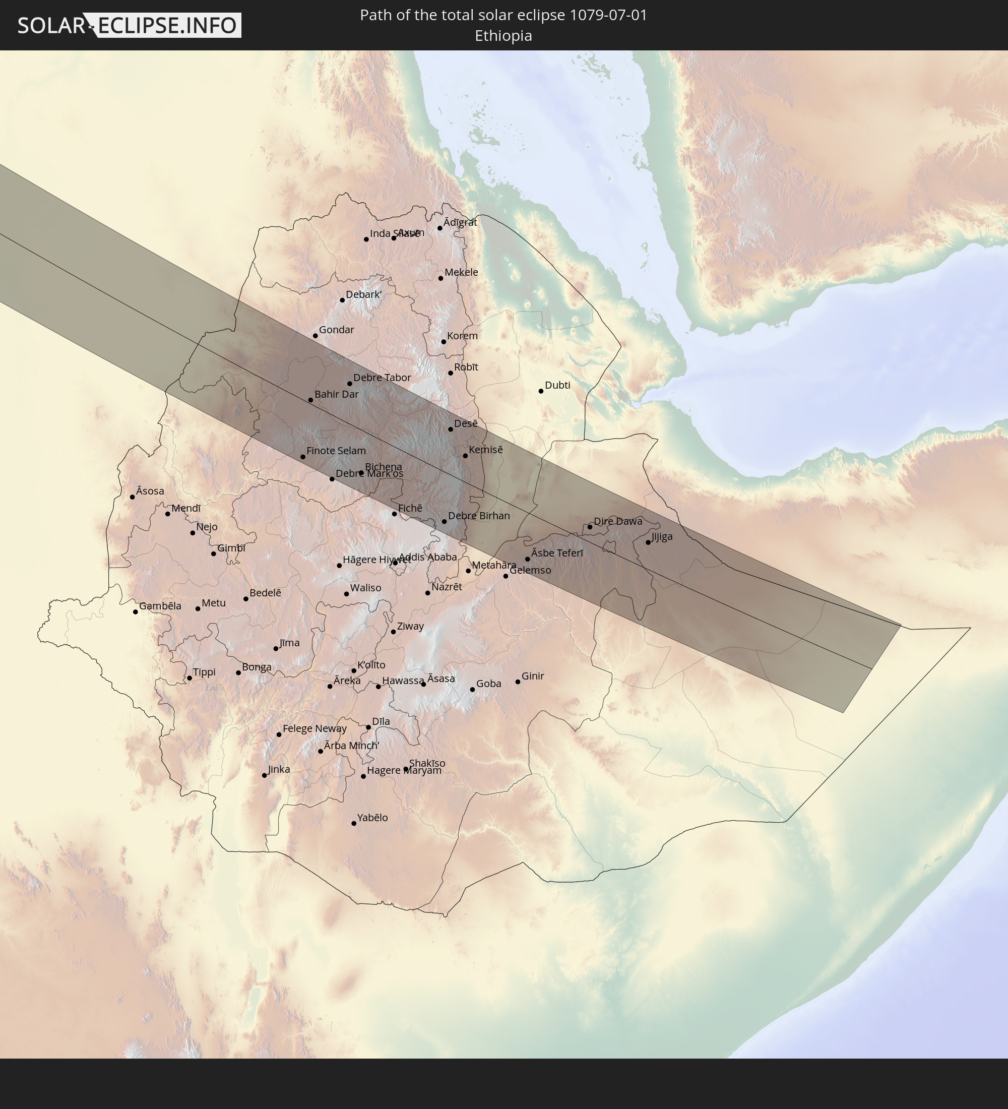 Äthiopien
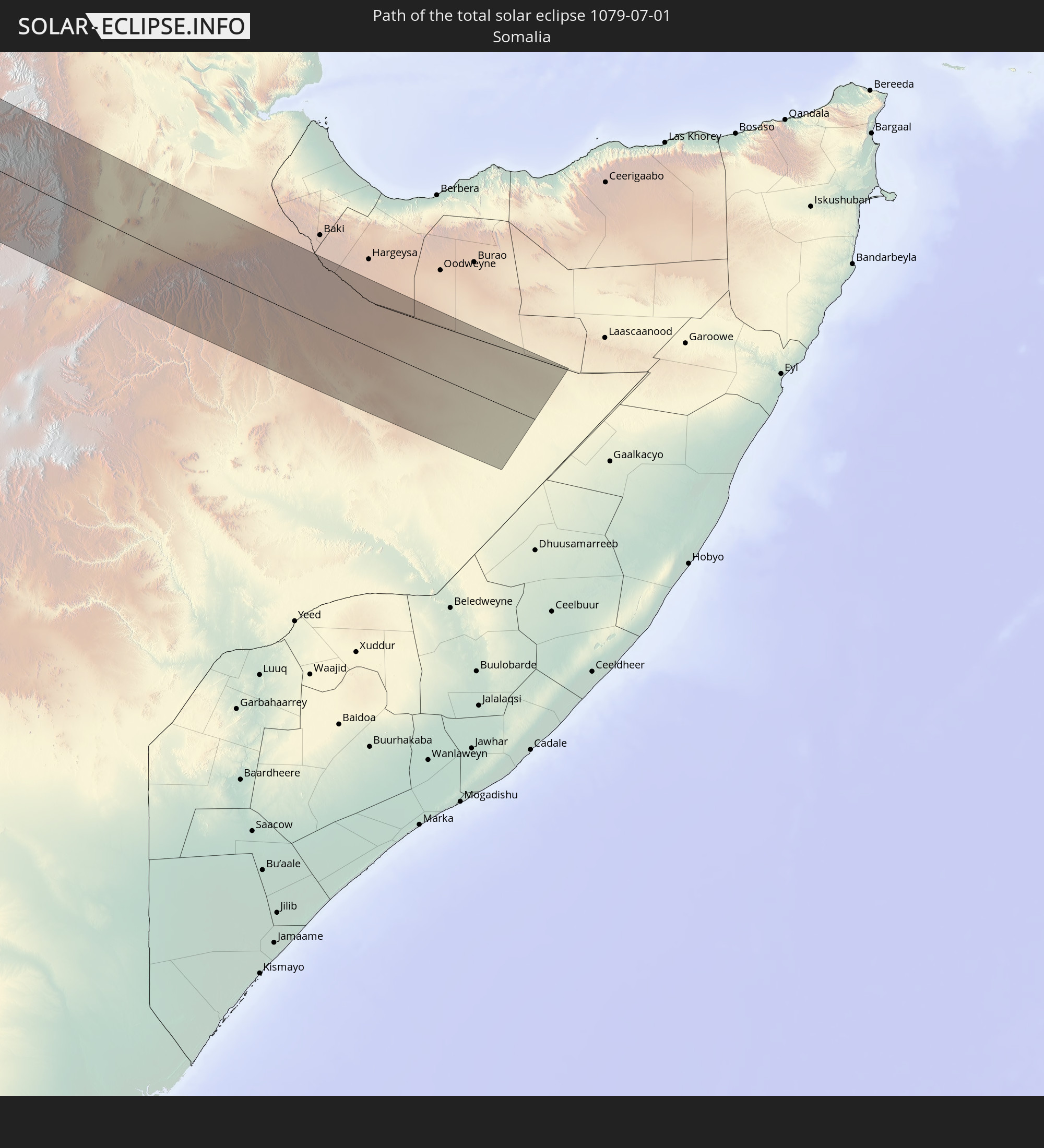 Somalia
In den folgenden Ländern ist die Sonnenfinsternis partiell zu sehen
 Russland
 Vereinigte Staaten
 United States Minor Outlying Islands
 Kanada
 Mexiko
 Grönland
 Guatemala
 El Salvador
 Honduras
 Belize
 Nicaragua
 Costa Rica
 Kuba
Kuba
 Panama
 Kolumbien
 Kaimaninseln
 Bahamas
 Jamaika
 Haiti
Haiti
 Venezuela
 Turks- und Caicosinseln
 Dominikanische Republik
 Aruba
Aruba
 Puerto Rico
 Amerikanische Jungferninseln
 Bermuda
 Britische Jungferninseln
 Anguilla
 Saint-Martin
 Saint-Barthélemy
 St. Kitts und Nevis
 Antigua und Barbuda
 Montserrat
 Trinidad und Tobago
 Guadeloupe
 Grenada
 Dominica
 St. Vincent und die Grenadinen
 Martinique
 St. Lucia
 Barbados
 Saint-Pierre und Miquelon
 Portugal
 Kap Verde
 Island
 Spanien
 Senegal
 Mauretanien
 Gambia
 Guinea-Bissau
 Guinea
 Sierra Leone
 Marokko
 Mali
Mali
 Liberia
 Irland
 Spitzbergen
 Algerien
 Vereinigtes Königreich
 Elfenbeinküste
 Färöer
 Burkina Faso
 Gibraltar
 Frankreich
 Isle of Man
 Ghana
Ghana
 Guernsey
 Jersey
 Togo
Togo
 Niger
Niger
 Benin
Benin
 Andorra
 Belgien
 Nigeria
 Niederlande
 Norwegen
 Äquatorialguinea
 Luxemburg
 Deutschland
 Schweiz
 São Tomé und Príncipe
 Italien
 Monaco
 Tunesien
 Dänemark
 Kamerun
 Gabun
Gabun
 Libyen
 Liechtenstein
 Österreich
 Schweden
 Republik Kongo
 Angola
 Namibia
 Tschechien
 Demokratische Republik Kongo
 San Marino
 Vatikanstadt
 Slowenien
 Tschad
 Kroatien
 Polen
Polen
 Malta
Malta
 Zentralafrikanische Republik
 Bosnien und Herzegowina
 Ungarn
 Slowakei
 Montenegro
 Serbien
 Albanien
 Åland Islands
 Griechenland
 Botswana
 Rumänien
 Mazedonien
 Finnland
 Litauen
 Lettland
 Estland
 Sudan
Sudan
 Sambia
 Ukraine
 Bulgarien
 Weißrussland
 Ägypten
 Simbabwe
 Türkei
 Moldawien
 Ruanda
 Burundi
 Tansania
 Uganda
 Mosambik
 Republik Zypern
 Malawi
 Äthiopien
 Kenia
Kenia
 Staat Palästina
 Israel
 Saudi-Arabien
 Jordanien
 Libanon
 Syrien
 Eritrea
 Irak
Irak
 Georgien
 Somalia
 Dschibuti
 Jemen
Jemen
 Armenien
 Iran
Iran
 Aserbaidschan
 Kasachstan
 Kuwait
 Bahrain
 Katar
Katar
 Vereinigte Arabische Emirate
 Oman
Oman
 Turkmenistan
 Usbekistan
 Afghanistan
 Pakistan
 Tadschikistan
 Kirgisistan
 Volksrepublik China
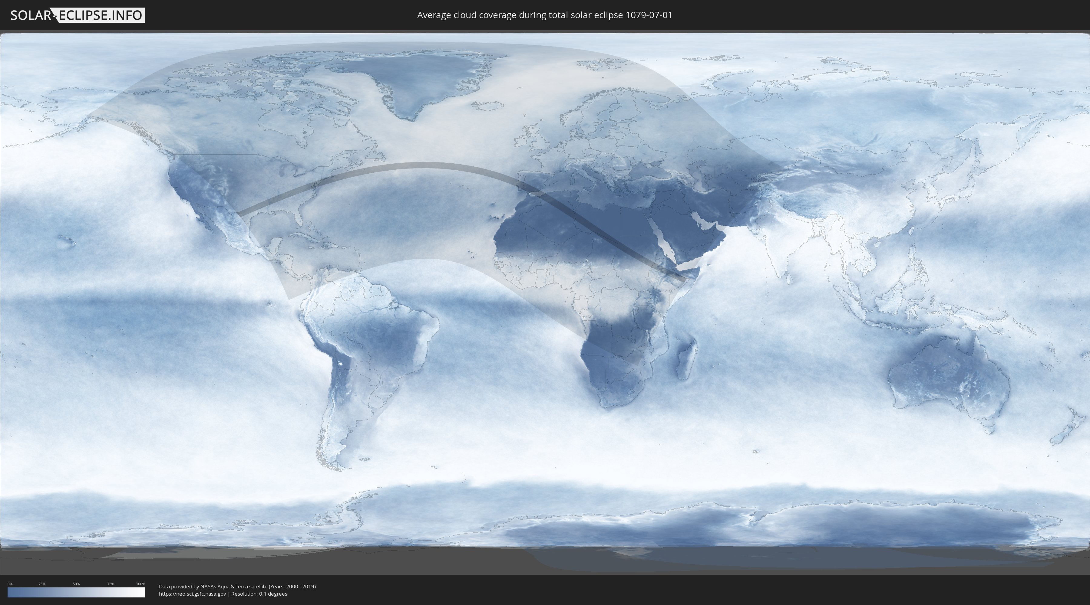
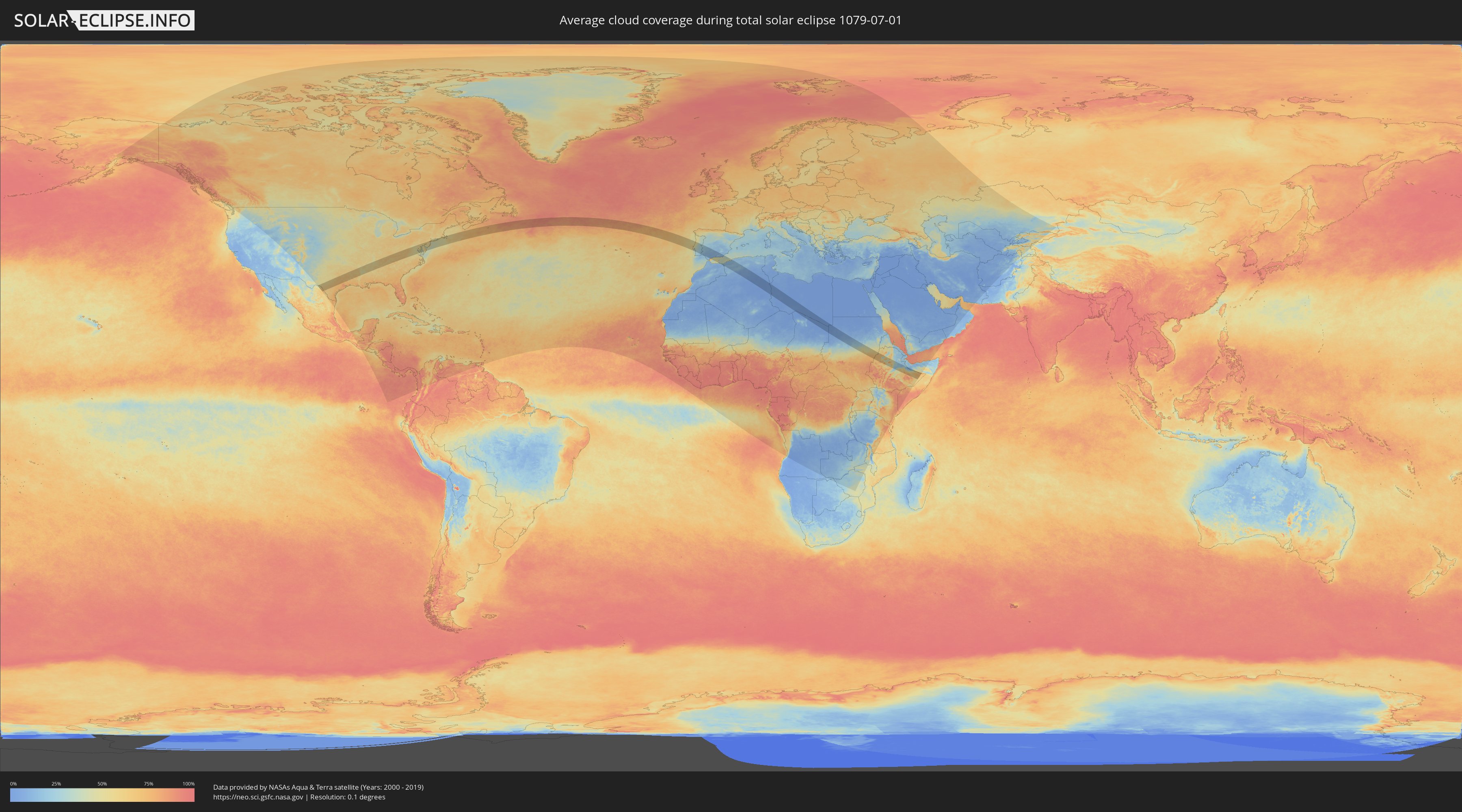
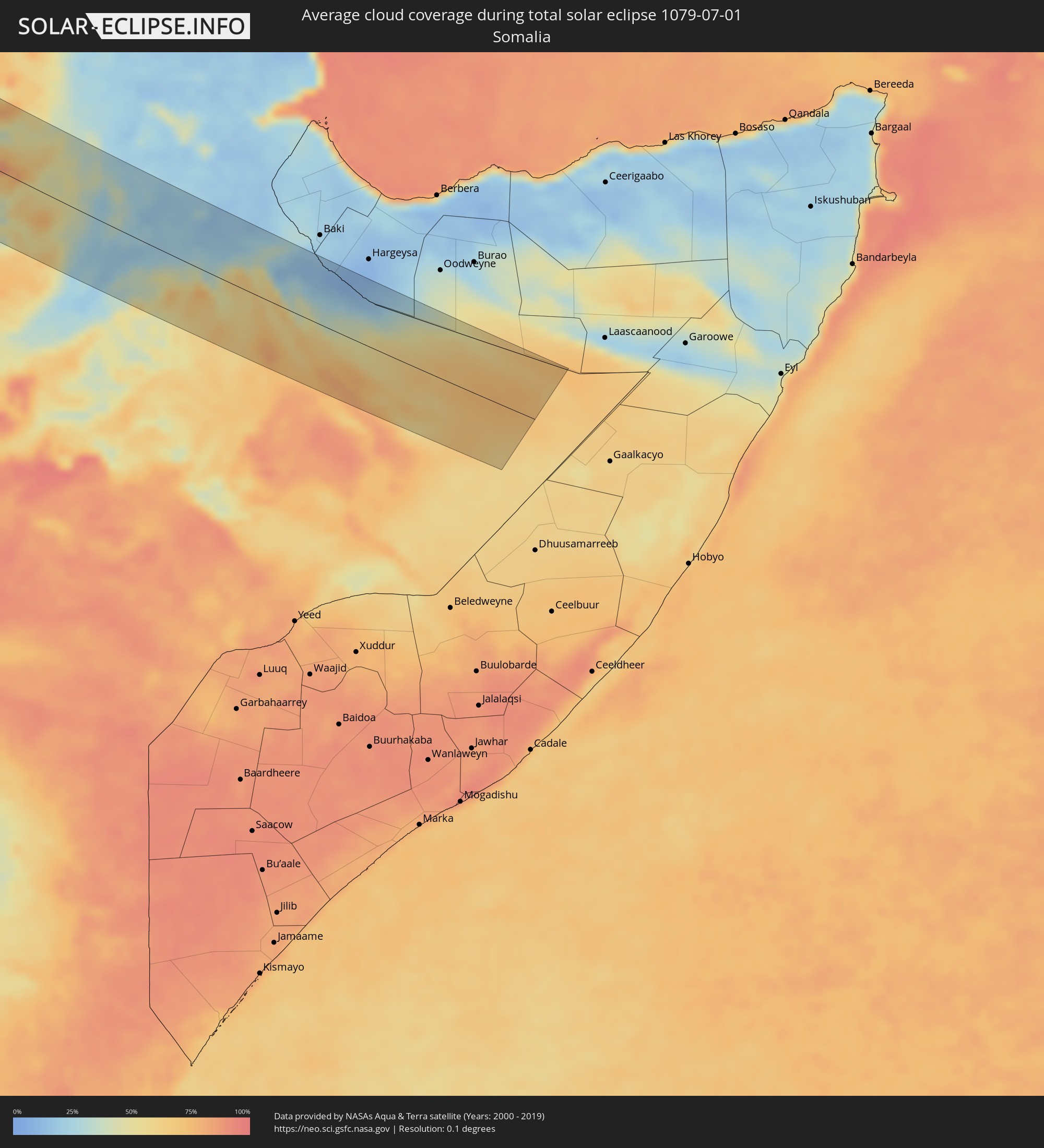
Wie wird das Wetter während der totalen Sonnenfinsternis am 01.07.1079?
Wo ist der beste Ort, um die totale Sonnenfinsternis vom 01.07.1079 zu beobachten?
Die folgenden Karten zeigen die durchschnittliche Bewölkung für den Tag, an dem die totale Sonnenfinsternis
stattfindet. Mit Hilfe der Karten lässt sich der Ort entlang des Finsternispfades eingrenzen,
der die besten Aussichen auf einen klaren wolkenfreien Himmel bietet.
Trotzdem muss man immer lokale Gegenenheiten beachten und sollte sich genau über das Wetter an seinem
gewählten Beobachtungsort informieren.
Die Daten stammen von den beiden NASA-Satelliten
AQUA und TERRA
und wurden über einen Zeitraum von 19 Jahren (2000 - 2019) gemittelt.
Detaillierte Länderkarten
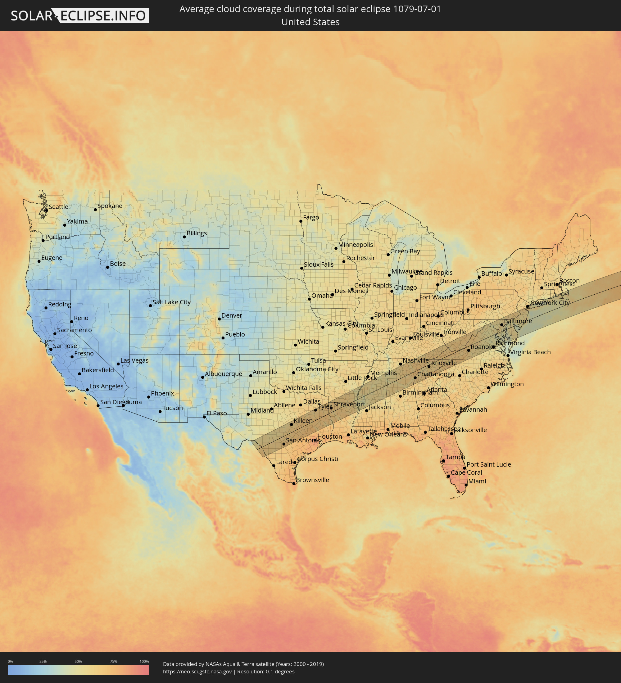 Vereinigte Staaten
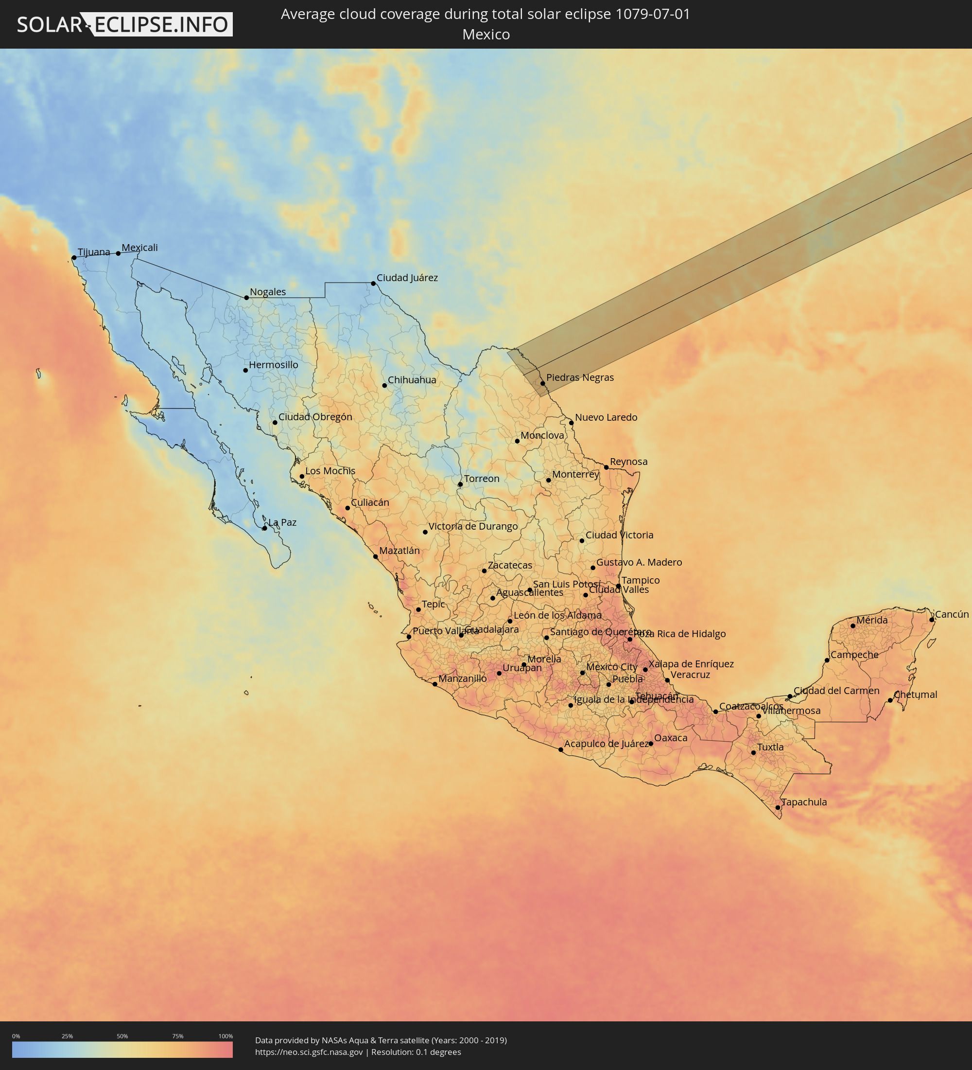 Mexiko
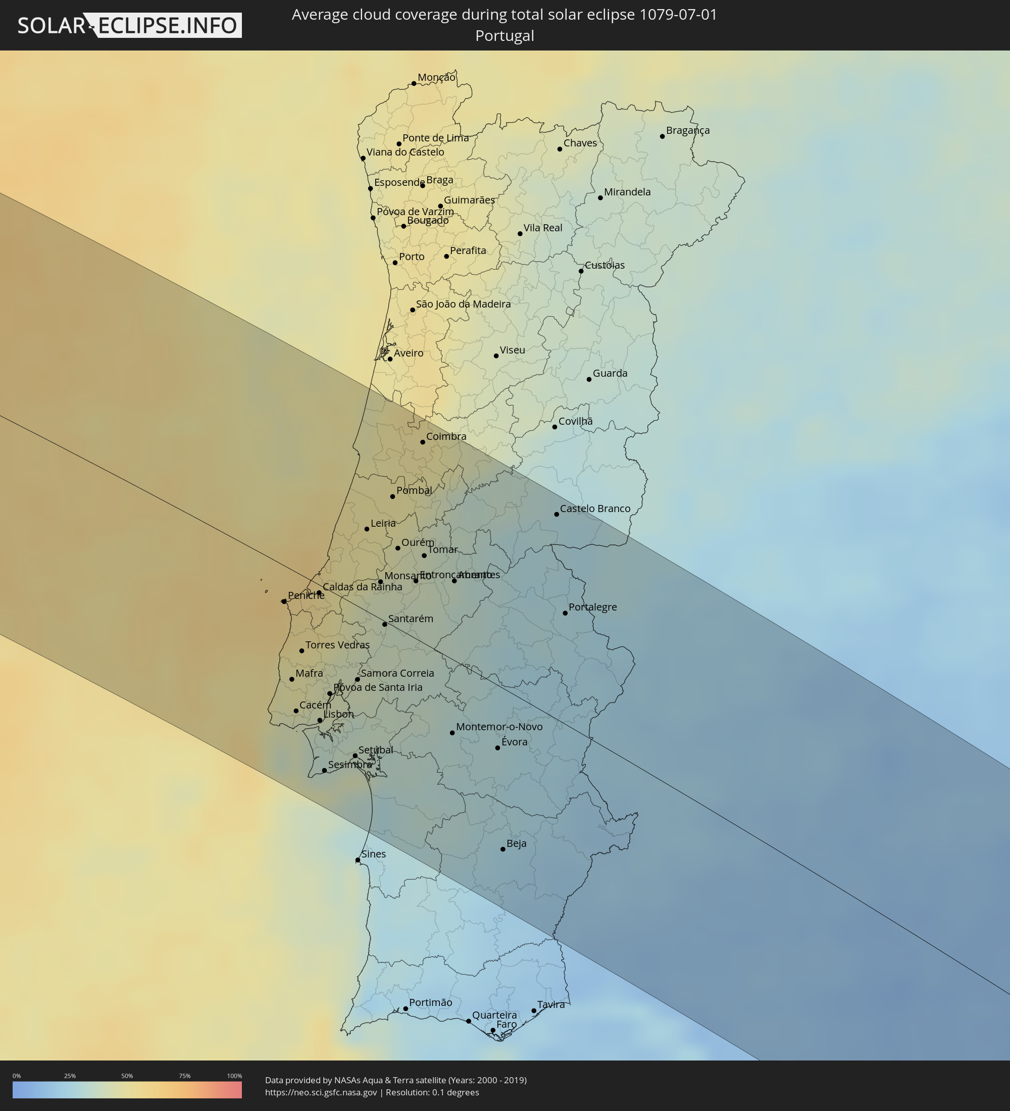 Portugal
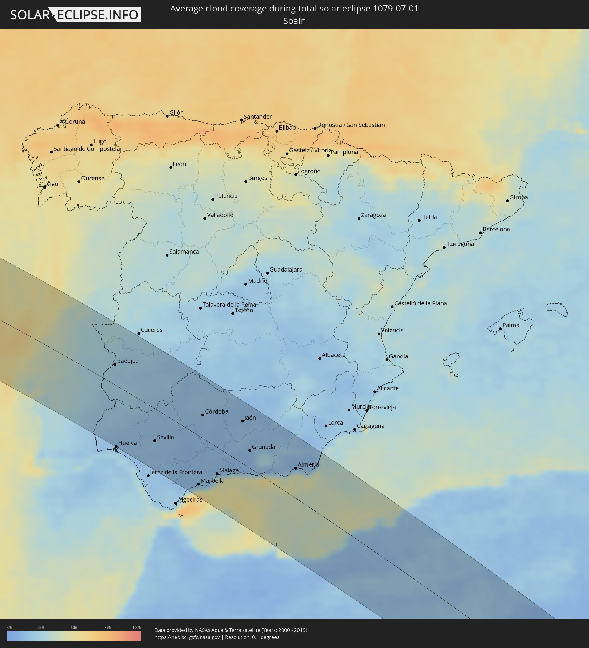 Spanien
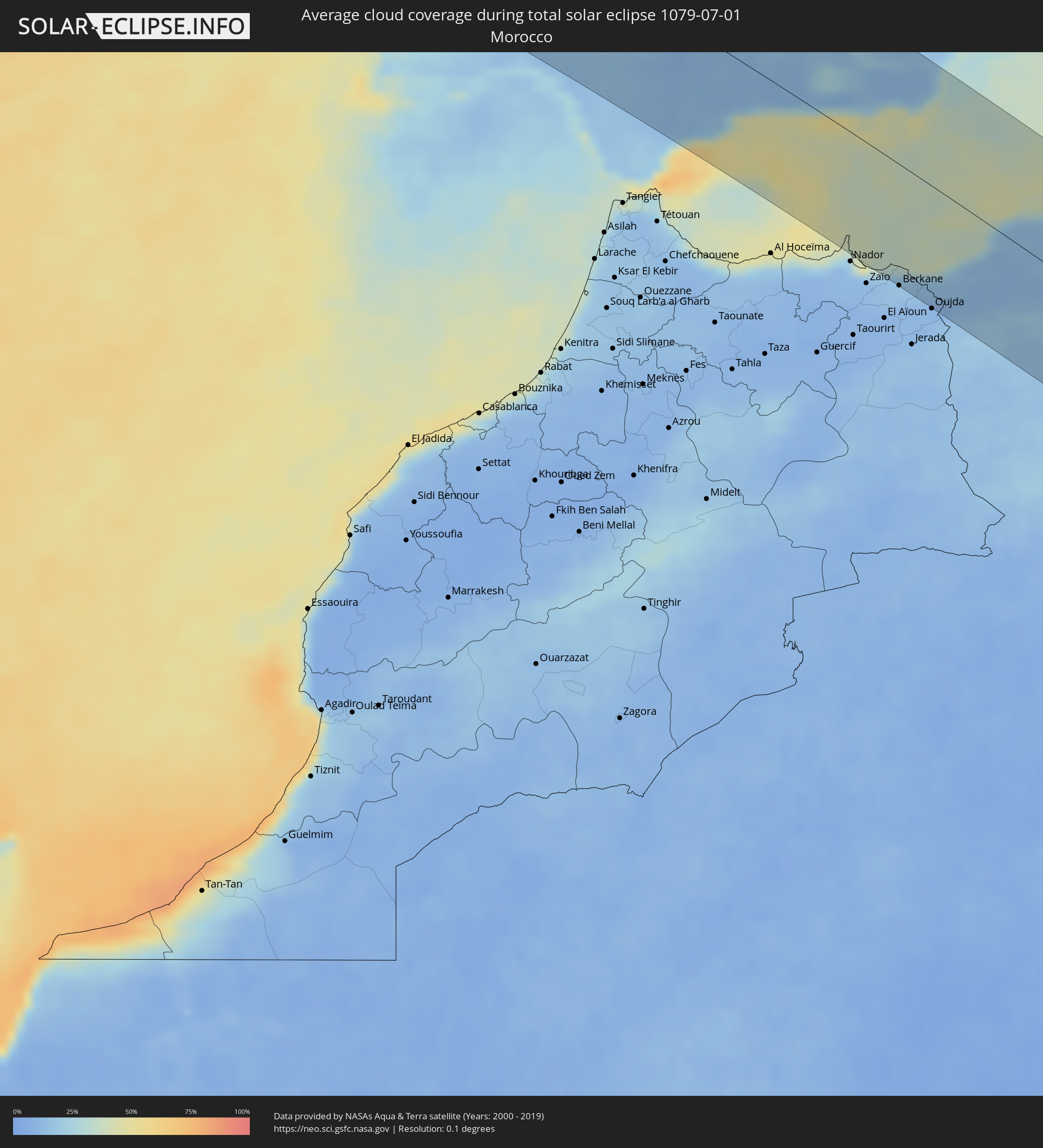 Marokko
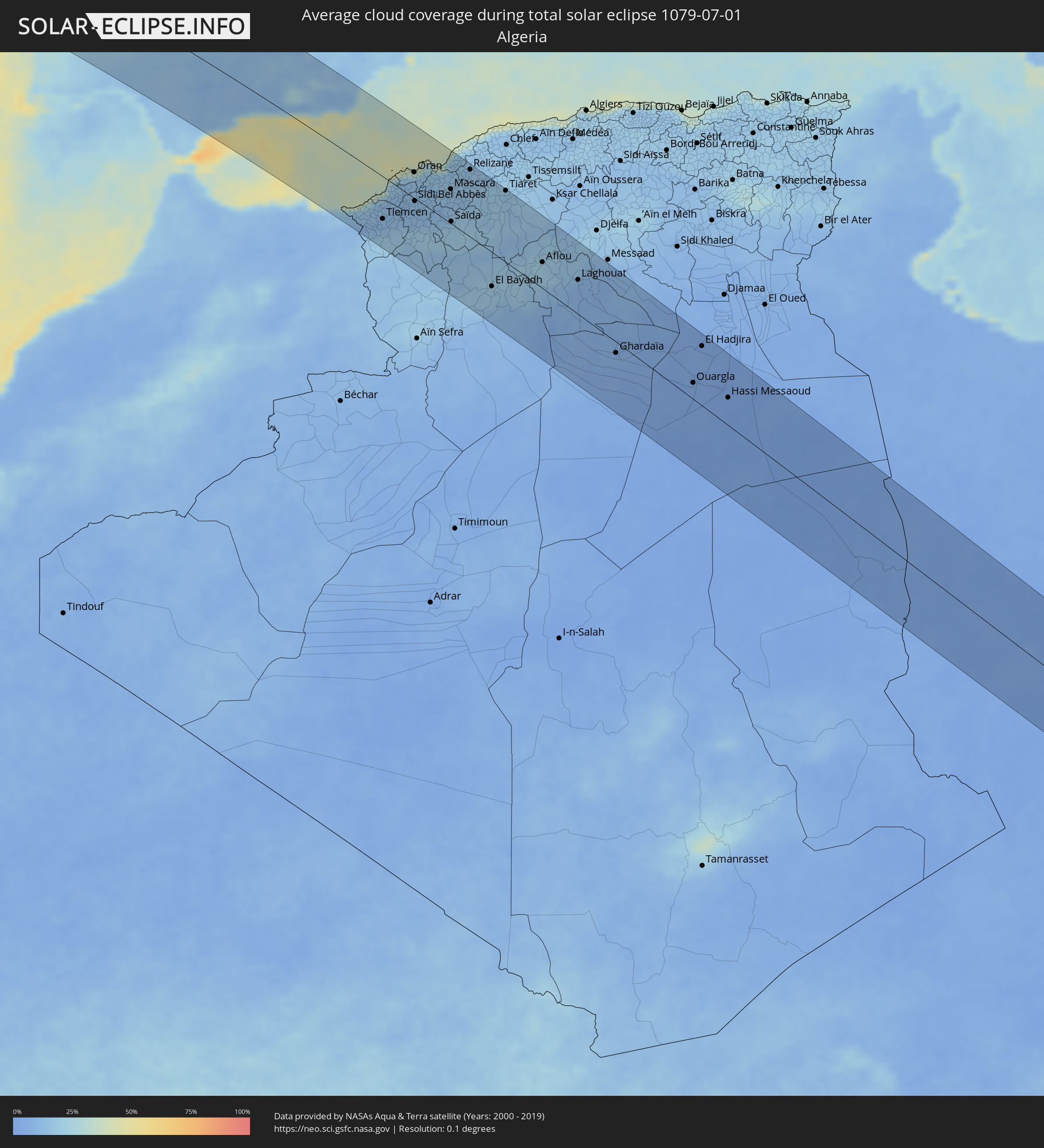 Algerien
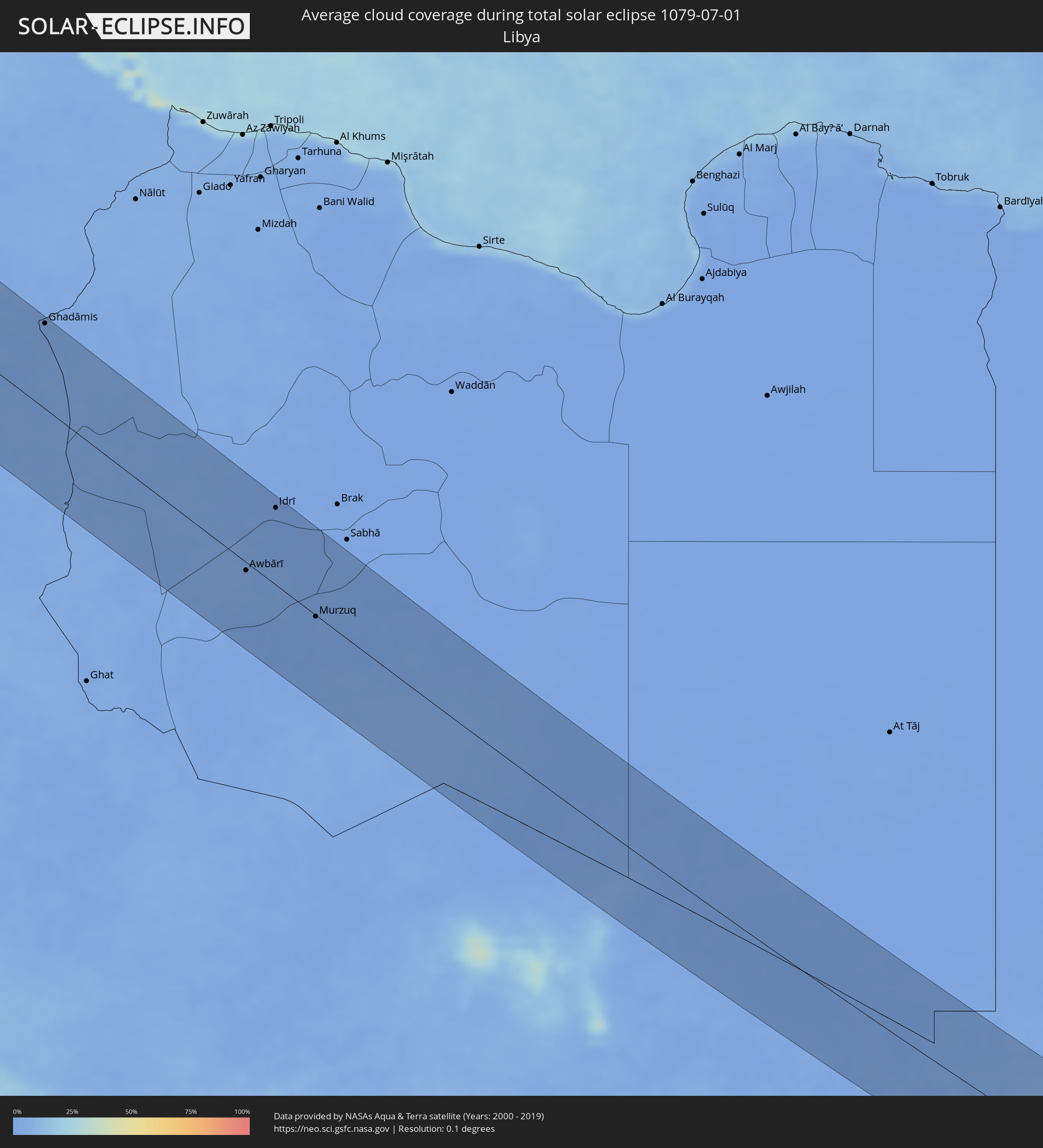 Libyen
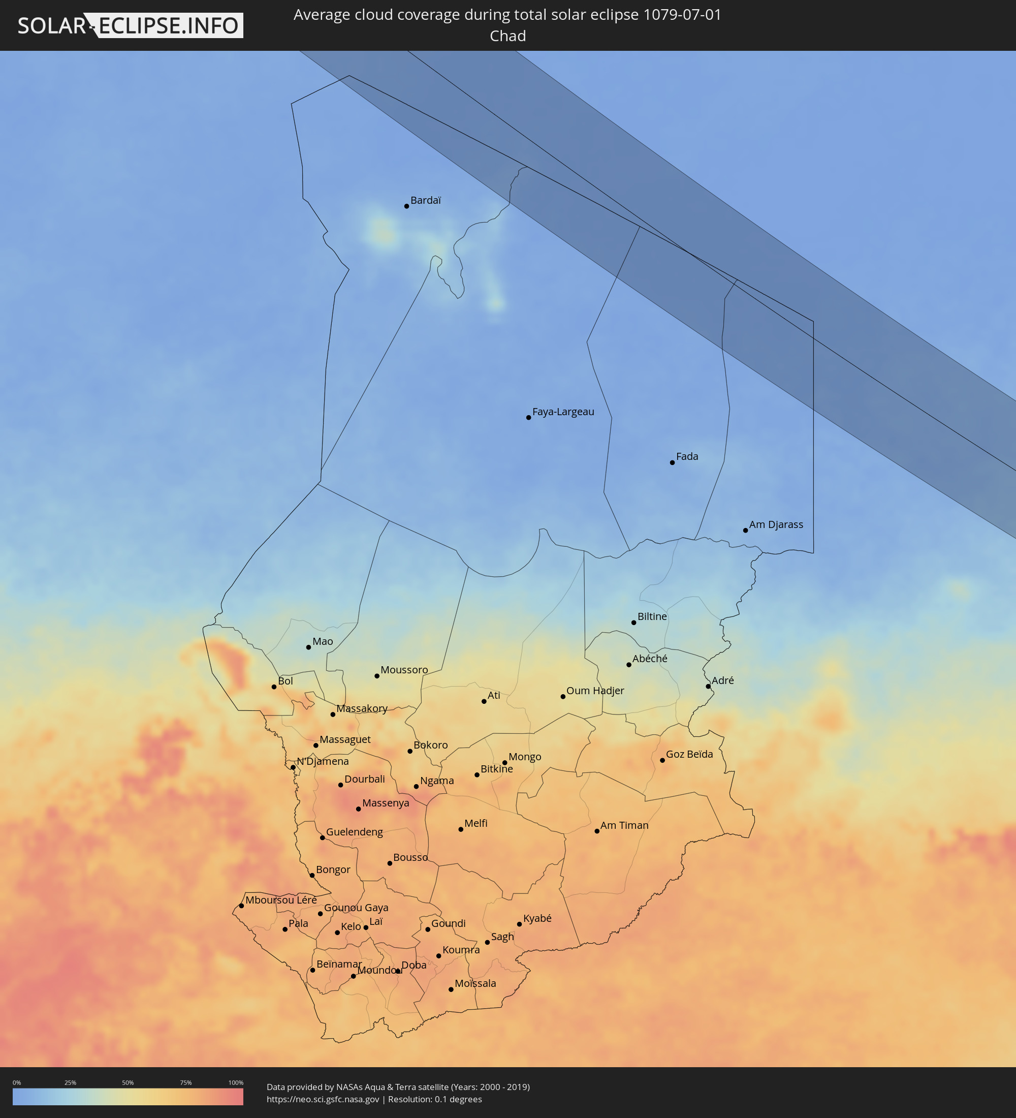 Tschad
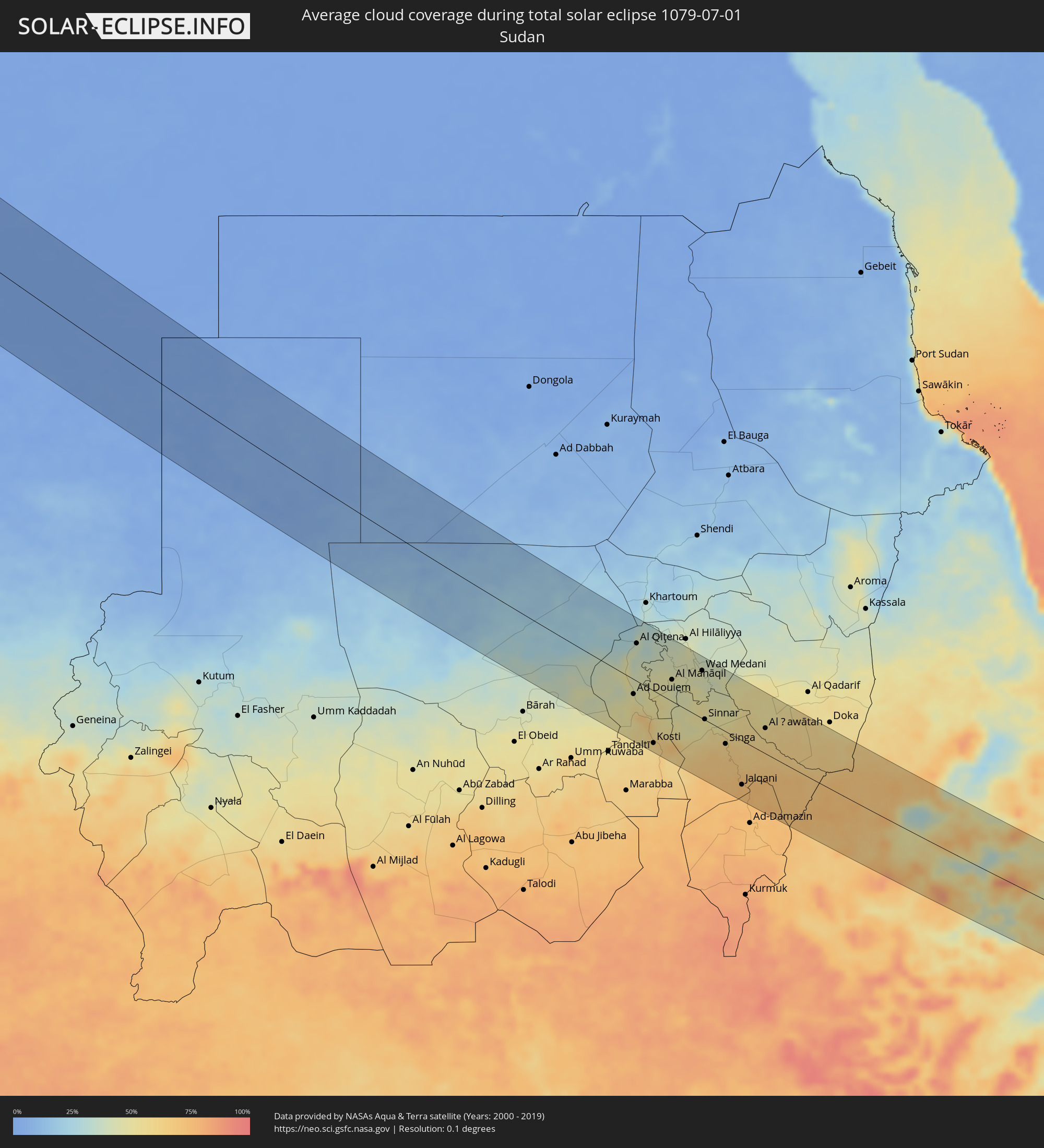 Sudan
Sudan
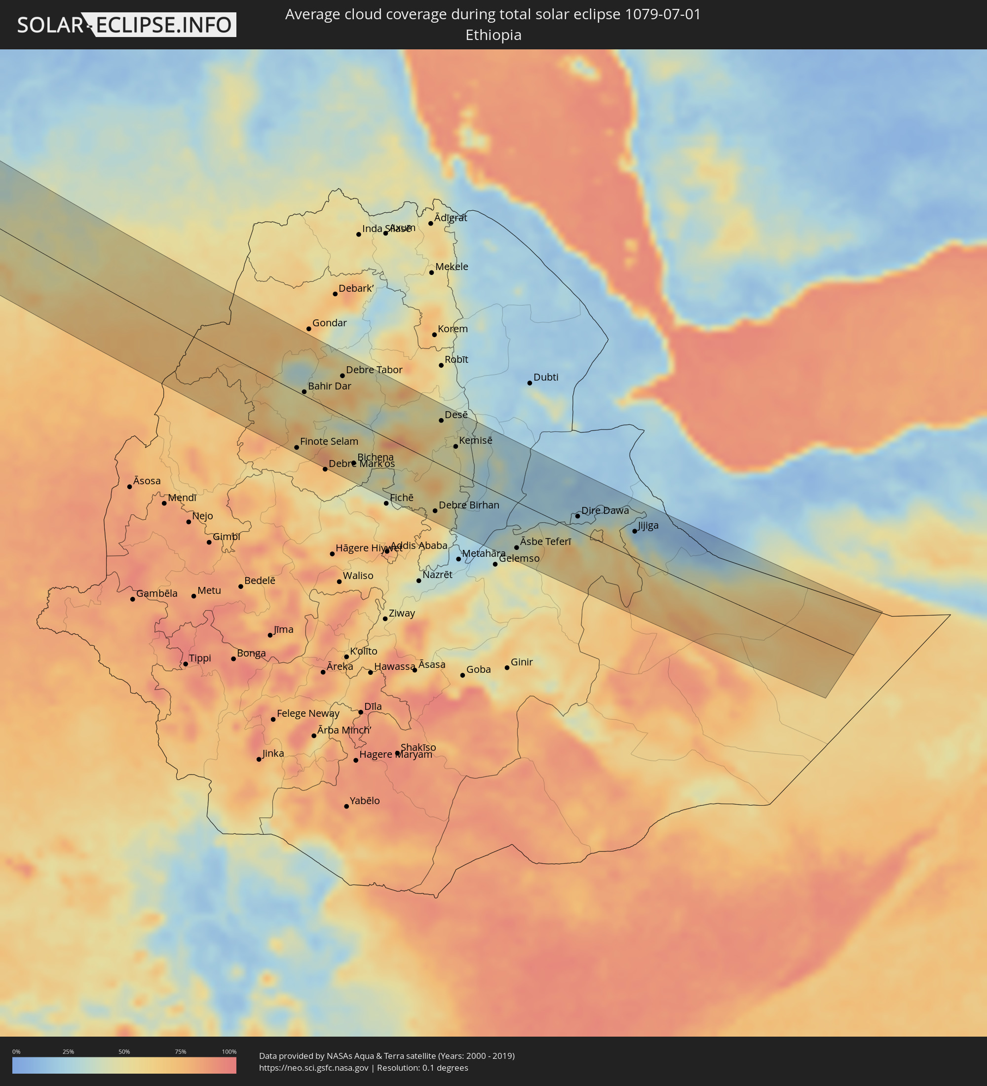 Äthiopien
 Somalia
Orte im Finsternispfad
Die nachfolgene Tabelle zeigt Städte und Orte mit mehr als 5.000 Einwohnern, die sich im Finsternispfad befinden. Städte mit mehr als 100.000 Einwohnern sind dick gekennzeichnet. Mit einem Klick auf den Ort öffnet sich eine Detailkarte die die Lage des jeweiligen Ortes zusammen mit dem Verlauf der zentralen Finsternis präsentiert.
| Ort | Typ | Dauer der Verfinsterung | Ortszeit bei maximaler Verfinsterung | Entfernung zur Zentrallinie | Ø Bewölkung |
|
Ciudad Acuña, Coahuila
|
total | - | 05:17:24 UTC-06:36 | 22 km | 62% |
|
Piedras Negras, Coahuila
|
total | - | 05:16:49 UTC-06:36 | 58 km | 65% |
|
San Antonio, Texas
|
total | - | 05:53:23 UTC-06:00 | 74 km | 69% |
|
Austin, Texas
|
total | - | 05:53:51 UTC-06:00 | 22 km | 67% |
|
Killeen, Texas
|
total | - | 05:54:32 UTC-06:00 | 62 km | 62% |
|
Round Rock, Texas
|
total | - | 05:54:02 UTC-06:00 | 0 km | 65% |
|
Waco, Texas
|
total | - | 05:54:46 UTC-06:00 | 80 km | 64% |
|
College Station, Texas
|
total | - | 05:53:51 UTC-06:00 | 46 km | 73% |
|
Tyler, Texas
|
total | - | 05:55:06 UTC-06:00 | 82 km | 68% |
|
Shreveport, Louisiana
|
total | - | 05:55:03 UTC-06:00 | 34 km | 65% |
|
Huntsville, Alabama
|
total | - | 05:56:59 UTC-06:00 | 39 km | 63% |
|
Murfreesboro, Tennessee
|
total | - | 05:58:06 UTC-06:00 | 65 km | 60% |
|
Chattanooga, Tennessee
|
total | - | 06:57:26 UTC-05:00 | 58 km | 62% |
|
Knoxville, Tennessee
|
total | - | 06:58:34 UTC-05:00 | 20 km | 64% |
|
Roanoke, Virginia
|
total | - | 07:00:53 UTC-05:00 | 38 km | 64% |
|
Richmond, Virginia
|
total | - | 07:02:02 UTC-05:00 | 99 km | 55% |
|
Washington, D.C., Washington, D.C.
|
total | - | 07:03:40 UTC-05:00 | 23 km | 58% |
|
Columbia, Maryland
|
total | - | 07:04:08 UTC-05:00 | 51 km | 59% |
|
Baltimore, Maryland
|
total | - | 07:04:17 UTC-05:00 | 49 km | 58% |
|
Philadelphia, Pennsylvania
|
total | - | 07:05:40 UTC-05:00 | 67 km | 59% |
|
Edison, New Jersey
|
total | - | 07:06:40 UTC-05:00 | 100 km | 61% |
|
Toms River, New Jersey
|
total | - | 07:06:08 UTC-05:00 | 35 km | 57% |
|
Staten Island, New York
|
total | - | 07:06:51 UTC-05:00 | 95 km | 58% |
|
Brooklyn, New York
|
total | - | 07:07:03 UTC-05:00 | 98 km | 60% |
|
New Bedford, Massachusetts
|
total | - | 07:09:51 UTC-05:00 | 104 km | 60% |
|
Peniche, Leiria
|
total | - | 13:11:53 UTC-00:36 | 19 km | 60% |
|
Cacém, Lisbon
|
total | - | 13:12:50 UTC-00:36 | 73 km | 42% |
|
Torres Vedras, Lisbon
|
total | - | 13:12:28 UTC-00:36 | 40 km | 49% |
|
Caldas da Rainha, Leiria
|
total | - | 13:12:15 UTC-00:36 | 4 km | 54% |
|
Lisbon, Lisbon
|
total | - | 13:13:12 UTC-00:36 | 71 km | 35% |
|
Sesimbra, Setúbal
|
total | - | 13:13:38 UTC-00:36 | 96 km | 43% |
|
Póvoa de Santa Iria, Lisbon
|
total | - | 13:13:07 UTC-00:36 | 54 km | 42% |
|
Setúbal, Setúbal
|
total | - | 13:13:53 UTC-00:36 | 79 km | 42% |
|
Samora Correia, Santarém
|
total | - | 13:13:21 UTC-00:36 | 39 km | 38% |
|
Leiria, Leiria
|
total | - | 13:12:22 UTC-00:36 | 43 km | 49% |
|
Monsanto, Santarém
|
total | - | 13:12:54 UTC-00:36 | 19 km | 41% |
|
Santarém, Santarém
|
total | - | 13:13:16 UTC-00:36 | 2 km | 38% |
|
Pombal, Leiria
|
total | - | 13:12:26 UTC-00:36 | 67 km | 49% |
|
Ourém, Santarém
|
total | - | 13:12:52 UTC-00:36 | 42 km | 41% |
|
Entroncamento, Santarém
|
total | - | 13:13:19 UTC-00:36 | 30 km | 39% |
|
Coimbra, Coimbra
|
total | - | 13:12:23 UTC-00:36 | 104 km | 50% |
|
Tomar, Santarém
|
total | - | 13:13:14 UTC-00:36 | 46 km | 39% |
|
Montemor-o-Novo, Évora
|
total | - | 13:14:53 UTC-00:36 | 39 km | 30% |
|
Abrantes, Santarém
|
total | - | 13:13:46 UTC-00:36 | 41 km | 36% |
|
Évora, Évora
|
total | - | 13:15:33 UTC-00:36 | 33 km | 29% |
|
Beja, Beja
|
total | - | 13:16:23 UTC-00:36 | 85 km | 24% |
|
Castelo Branco, Castelo Branco
|
total | - | 13:14:28 UTC-00:36 | 106 km | 29% |
|
Portalegre, Portalegre
|
total | - | 13:15:19 UTC-00:36 | 57 km | 27% |
|
Badajoz, Extremadura
|
total | - | 13:53:25 UTC+00:00 | 38 km | 21% |
|
Huelva, Andalusia
|
total | - | 13:55:49 UTC+00:00 | 116 km | 13% |
|
Mérida, Extremadura
|
total | - | 13:54:24 UTC+00:00 | 69 km | 19% |
|
Sevilla, Andalusia
|
total | - | 13:57:16 UTC+00:00 | 60 km | 16% |
|
Utrera, Andalusia
|
total | - | 13:57:53 UTC+00:00 | 70 km | 14% |
|
Estepona, Andalusia
|
total | - | 14:00:05 UTC+00:00 | 112 km | 55% |
|
Écija, Andalusia
|
total | - | 13:58:30 UTC+00:00 | 4 km | 12% |
|
Marbella, Andalusia
|
total | - | 14:00:23 UTC+00:00 | 92 km | 44% |
|
Córdoba, Andalusia
|
total | - | 13:58:28 UTC+00:00 | 43 km | 13% |
|
Mijas, Andalusia
|
total | - | 14:00:40 UTC+00:00 | 72 km | 32% |
|
Antequera, Andalusia
|
total | - | 14:00:08 UTC+00:00 | 29 km | 12% |
|
Lucena, Andalusia
|
total | - | 13:59:40 UTC+00:00 | 11 km | 12% |
|
Málaga, Andalusia
|
total | - | 14:00:49 UTC+00:00 | 50 km | 39% |
|
Vélez-Málaga, Andalusia
|
total | - | 14:01:14 UTC+00:00 | 29 km | 28% |
|
Andújar, Andalusia
|
total | - | 13:59:24 UTC+00:00 | 91 km | 12% |
|
Jaén, Andalusia
|
total | - | 14:00:13 UTC+00:00 | 78 km | 14% |
|
Linares, Andalusia
|
total | - | 13:59:58 UTC+00:00 | 116 km | 11% |
|
Granada, Andalusia
|
total | - | 14:01:24 UTC+00:00 | 33 km | 11% |
|
Motril, Andalusia
|
total | - | 14:02:13 UTC+00:00 | 4 km | 25% |
|
Melilla, Melilla
|
total | - | 14:05:25 UTC+00:00 | 112 km | 40% |
|
El Ejido, Andalusia
|
total | - | 14:03:16 UTC+00:00 | 32 km | 23% |
|
Roquetas de Mar, Andalusia
|
total | - | 14:03:36 UTC+00:00 | 41 km | 34% |
|
Almería, Andalusia
|
total | - | 14:03:43 UTC+00:00 | 56 km | 41% |
|
Berkane, Oriental
|
total | - | 13:36:39 UTC-00:30 | 115 km | 12% |
|
Ahfir, Oriental
|
total | - | 13:36:56 UTC-00:30 | 101 km | 14% |
|
Remchi, Tlemcen
|
total | - | 14:17:28 UTC+00:09 | 57 km | 13% |
|
Beni Saf, Aïn Témouchent
|
total | - | 14:17:09 UTC+00:09 | 32 km | 17% |
|
Sebdou, Tlemcen
|
total | - | 14:18:18 UTC+00:09 | 91 km | 19% |
|
Tlemcen, Tlemcen
|
total | - | 14:17:56 UTC+00:09 | 68 km | 12% |
|
Aïn Temouchent, Aïn Témouchent
|
total | - | 14:17:31 UTC+00:09 | 20 km | 11% |
|
Oran, Oran
|
total | - | 14:17:38 UTC+00:09 | 41 km | 18% |
|
Sidi Bel Abbès, Sidi Bel Abbès
|
total | - | 14:18:27 UTC+00:09 | 4 km | 14% |
|
Sig, Mascara
|
total | - | 14:18:33 UTC+00:09 | 49 km | 14% |
|
Mostaganem, Mostaganem
|
total | - | 14:18:18 UTC+00:09 | 101 km | 19% |
|
Mascara, Mascara
|
total | - | 14:19:15 UTC+00:09 | 55 km | 15% |
|
Saïda, Saida
|
total | - | 14:20:11 UTC+00:09 | 4 km | 18% |
|
Relizane, Relizane
|
total | - | 14:19:17 UTC+00:09 | 107 km | 15% |
|
El Bayadh, El Bayadh
|
total | - | 14:23:18 UTC+00:09 | 55 km | 18% |
|
Frenda, Tiaret
|
total | - | 14:21:05 UTC+00:09 | 72 km | 18% |
|
Tiaret, Tiaret
|
total | - | 14:20:57 UTC+00:09 | 114 km | 15% |
|
Sougueur, Tiaret
|
total | - | 14:21:30 UTC+00:09 | 107 km | 17% |
|
Aflou, Laghouat
|
total | - | 14:24:06 UTC+00:09 | 42 km | 20% |
|
Laghouat, Laghouat
|
total | - | 14:25:39 UTC+00:09 | 55 km | 8% |
|
Metlili Chaamba, Ghardaia
|
total | - | 14:29:13 UTC+00:09 | 40 km | 5% |
|
Ghardaïa, Ghardaia
|
total | - | 14:28:54 UTC+00:09 | 18 km | 7% |
|
Berriane, Ghardaia
|
total | - | 14:28:27 UTC+00:09 | 18 km | 6% |
|
Ouargla, Ouargla
|
total | - | 14:31:53 UTC+00:09 | 26 km | 3% |
|
Hassi Messaoud, Ouargla
|
total | - | 14:33:15 UTC+00:09 | 45 km | 3% |
|
Ghadāmis, Sha‘bīyat Nālūt
|
total | - | 15:23:03 UTC+00:52 | 107 km | 2% |
|
Awbārī, Sha‘bīyat Wādī al Ḩayāt
|
total | - | 15:32:00 UTC+00:52 | 10 km | 2% |
|
Idrī, Ash Shāţiʼ
|
total | - | 15:30:58 UTC+00:52 | 99 km | 1% |
|
Murzuq, Murzuq
|
total | - | 15:34:03 UTC+00:52 | 2 km | 1% |
|
Wad az Zāki, White Nile
|
total | - | 17:14:59 UTC+02:10 | 14 km | 49% |
|
Ad Douiem, White Nile
|
total | - | 17:15:29 UTC+02:10 | 24 km | 50% |
|
Al Qiţena, White Nile
|
total | - | 17:14:33 UTC+02:10 | 62 km | 38% |
|
Um Jar Al Gharbiyya, White Nile
|
total | - | 17:15:42 UTC+02:10 | 39 km | 55% |
|
Al Kawa, White Nile
|
total | - | 17:15:46 UTC+02:10 | 39 km | 66% |
|
Kosti, White Nile
|
total | - | 17:16:24 UTC+02:10 | 87 km | 60% |
|
Rabak, White Nile
|
total | - | 17:16:23 UTC+02:10 | 81 km | 60% |
|
Al Kiremit al ‘Arakiyyīn, Al Jazīrah
|
total | - | 17:15:10 UTC+02:10 | 43 km | 47% |
|
Al Manāqil, Al Jazīrah
|
total | - | 17:15:16 UTC+02:10 | 36 km | 44% |
|
Kināna, Sinnār
|
total | - | 17:15:31 UTC+02:10 | 25 km | 44% |
|
Al Hasaheisa, Al Jazīrah
|
total | - | 17:14:45 UTC+02:10 | 101 km | 45% |
|
Al Masallamiyya, Al Jazīrah
|
total | - | 17:14:57 UTC+02:10 | 86 km | 44% |
|
Wad Medani, Al Jazīrah
|
total | - | 17:15:08 UTC+02:10 | 79 km | 44% |
|
Sinnar, Sinnār
|
total | - | 17:16:01 UTC+02:10 | 1 km | 50% |
|
Maiurno, Sinnār
|
total | - | 17:16:11 UTC+02:10 | 9 km | 57% |
|
As Sūkī, Sinnār
|
total | - | 17:16:18 UTC+02:10 | 7 km | 59% |
|
Singa, Sinnār
|
total | - | 17:16:28 UTC+02:10 | 21 km | 61% |
|
Ad Dindar, Sinnār
|
total | - | 17:16:26 UTC+02:10 | 3 km | 61% |
|
Jalqani, Sinnār
|
total | - | 17:17:12 UTC+02:10 | 74 km | 72% |
|
Al Ḩawātah, Al Qaḑārif
|
total | - | 17:16:13 UTC+02:10 | 42 km | 57% |
|
Finote Selam, Amhara
|
total | - | 17:35:55 UTC+02:27 | 89 km | 62% |
|
Bahir Dar, Amhara
|
total | - | 17:35:04 UTC+02:27 | 5 km | 52% |
|
Addiet Canna, Amhara
|
total | - | 17:35:22 UTC+02:27 | 22 km | 57% |
|
Werota, Amhara
|
total | - | 17:34:44 UTC+02:27 | 53 km | 48% |
|
Ādīs Zemen, Amhara
|
total | - | 17:34:32 UTC+02:27 | 77 km | 45% |
|
Debre Tabor, Amhara
|
total | - | 17:34:46 UTC+02:27 | 62 km | 64% |
|
Debre Werk’, Amhara
|
total | - | 17:35:52 UTC+02:27 | 48 km | 57% |
|
Bichena, Amhara
|
total | - | 17:36:03 UTC+02:27 | 67 km | 61% |
|
Were Īlu, Amhara
|
total | - | 17:35:47 UTC+02:27 | 7 km | 54% |
|
Debre Birhan, Amhara
|
total | - | 17:36:34 UTC+02:27 | 79 km | 64% |
|
Desē, Amhara
|
total | - | 17:35:16 UTC+02:27 | 71 km | 61% |
|
Kombolcha, Amhara
|
total | - | 17:35:18 UTC+02:27 | 71 km | 56% |
|
Debre Sīna, Amhara
|
total | - | 17:36:23 UTC+02:27 | 51 km | 49% |
|
Kemisē, Amhara
|
total | - | 17:35:36 UTC+02:27 | 41 km | 50% |
|
Abomsa, Amhara
|
total | - | 17:36:14 UTC+02:27 | 27 km | 36% |
|
Batī, Amhara
|
total | - | 17:35:09 UTC+02:27 | 95 km | 38% |
|
Gewanē, Āfar
|
total | - | 17:35:58 UTC+02:27 | 23 km | 36% |
|
Āsbe Teferī, Oromiya
|
total | - | 17:36:52 UTC+02:27 | 75 km | 45% |
|
Hīrna, Oromiya
|
total | - | 17:36:43 UTC+02:27 | 50 km | 42% |
|
Deder, Oromiya
|
total | - | 17:36:34 UTC+02:27 | 25 km | 54% |
|
Dire Dawa, Dire Dawa
|
total | - | 17:36:15 UTC+02:27 | 24 km | 26% |
|
Harar, Harari
|
total | - | 17:36:26 UTC+02:27 | 7 km | 58% |
|
Jijiga, Somali
|
total | - | 17:36:15 UTC+02:27 | 43 km | 17% |