Totale Sonnenfinsternis vom 22.06.1126
| Wochentag: | Dienstag |
| Maximale Dauer der Verfinsterung: | 02m09s |
| Maximale Breite des Finsternispfades: | 69 km |
| Saroszyklus: | 103 |
| Bedeckungsgrad: | 100% |
| Magnitude: | 1.0193 |
| Gamma: | -0.3161 |
Wo kann man die Sonnenfinsternis vom 22.06.1126 sehen?
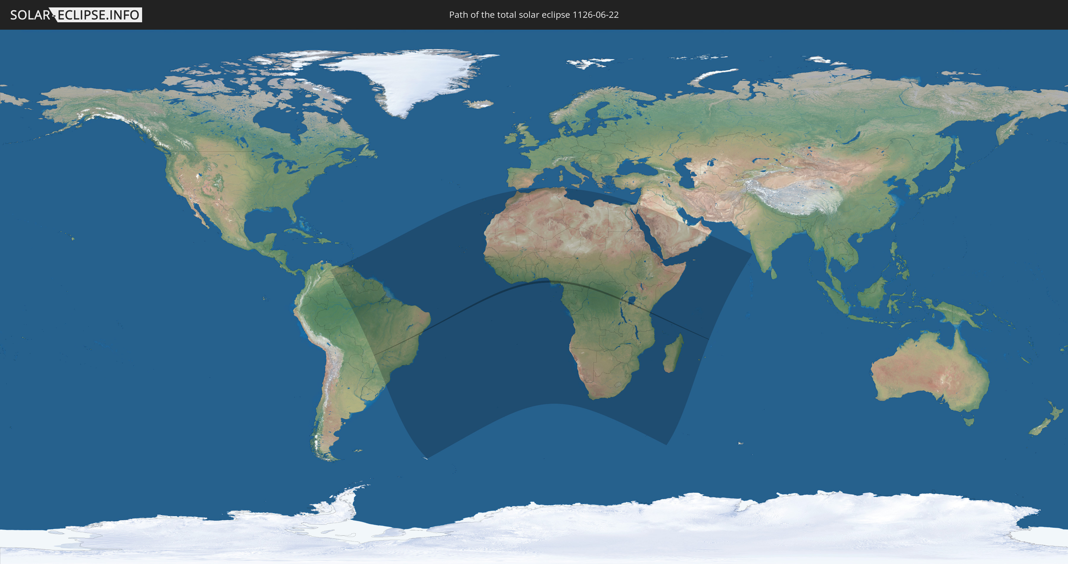
Die Sonnenfinsternis am 22.06.1126 kann man in 77 Ländern als partielle Sonnenfinsternis beobachten.
Der Finsternispfad verläuft durch 9 Länder. Nur in diesen Ländern ist sie als totale Sonnenfinsternis zu sehen.
In den folgenden Ländern ist die Sonnenfinsternis total zu sehen
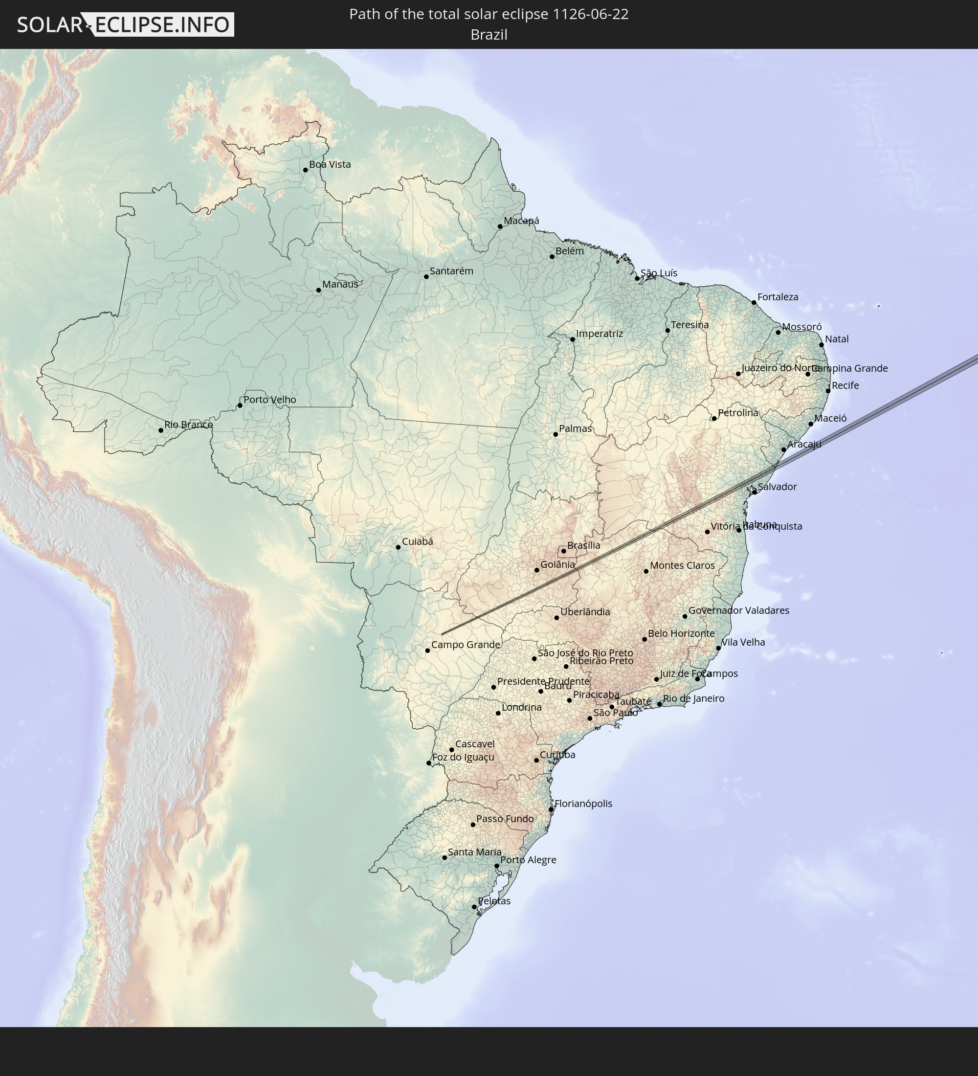 Brasilien
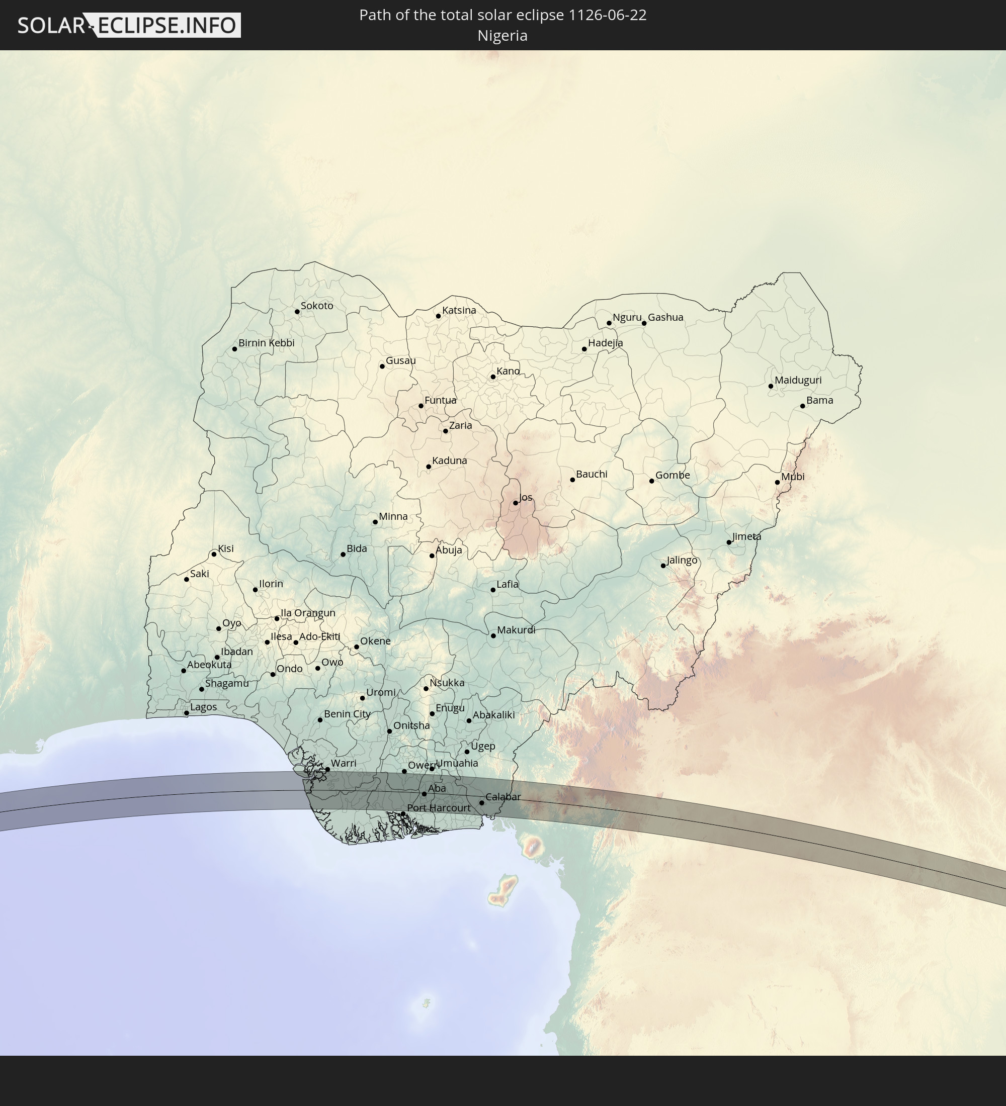 Nigeria
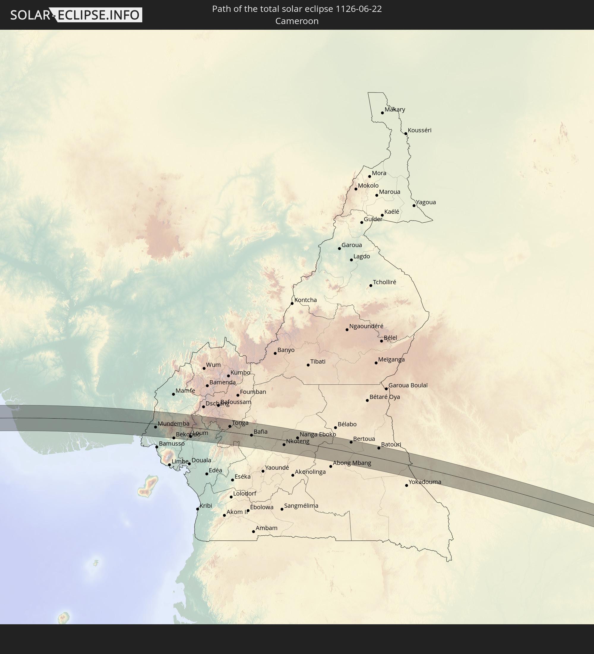 Kamerun
 Republik Kongo
 Demokratische Republik Kongo
 Zentralafrikanische Republik
 Ruanda
 Tansania
 Uganda
In den folgenden Ländern ist die Sonnenfinsternis partiell zu sehen
 Brasilien
 Venezuela
 Trinidad und Tobago
 Grenada
 Guyana
 Barbados
 Suriname
 Französisch-Guayana
 Portugal
 Kap Verde
 Spanien
 Senegal
 Mauretanien
 Gambia
 Guinea-Bissau
 Guinea
 St. Helena
 Sierra Leone
 Marokko
 Mali
Mali
 Liberia
 Algerien
 Elfenbeinküste
 Burkina Faso
 Ghana
Ghana
 Togo
Togo
 Niger
Niger
 Benin
Benin
 Nigeria
 Äquatorialguinea
 São Tomé und Príncipe
 Italien
 Tunesien
 Kamerun
 Gabun
Gabun
 Libyen
 Republik Kongo
 Angola
 Namibia
 Demokratische Republik Kongo
 Tschad
 Malta
Malta
 Zentralafrikanische Republik
 Südafrika
 Botswana
 Sudan
Sudan
 Sambia
 Ägypten
 Simbabwe
 Lesotho
 Ruanda
 Burundi
 Tansania
 Uganda
 Mosambik
 Swasiland
 Malawi
 Äthiopien
 Kenia
Kenia
 Staat Palästina
 Israel
 Saudi-Arabien
 Jordanien
 Eritrea
 Französische Süd- und Antarktisgebiete
 Somalia
 Dschibuti
 Jemen
Jemen
 Madagaskar
 Komoren
 Mayotte
 Seychellen
 Katar
Katar
 Vereinigte Arabische Emirate
 Oman
Oman
 Réunion
 Mauritius
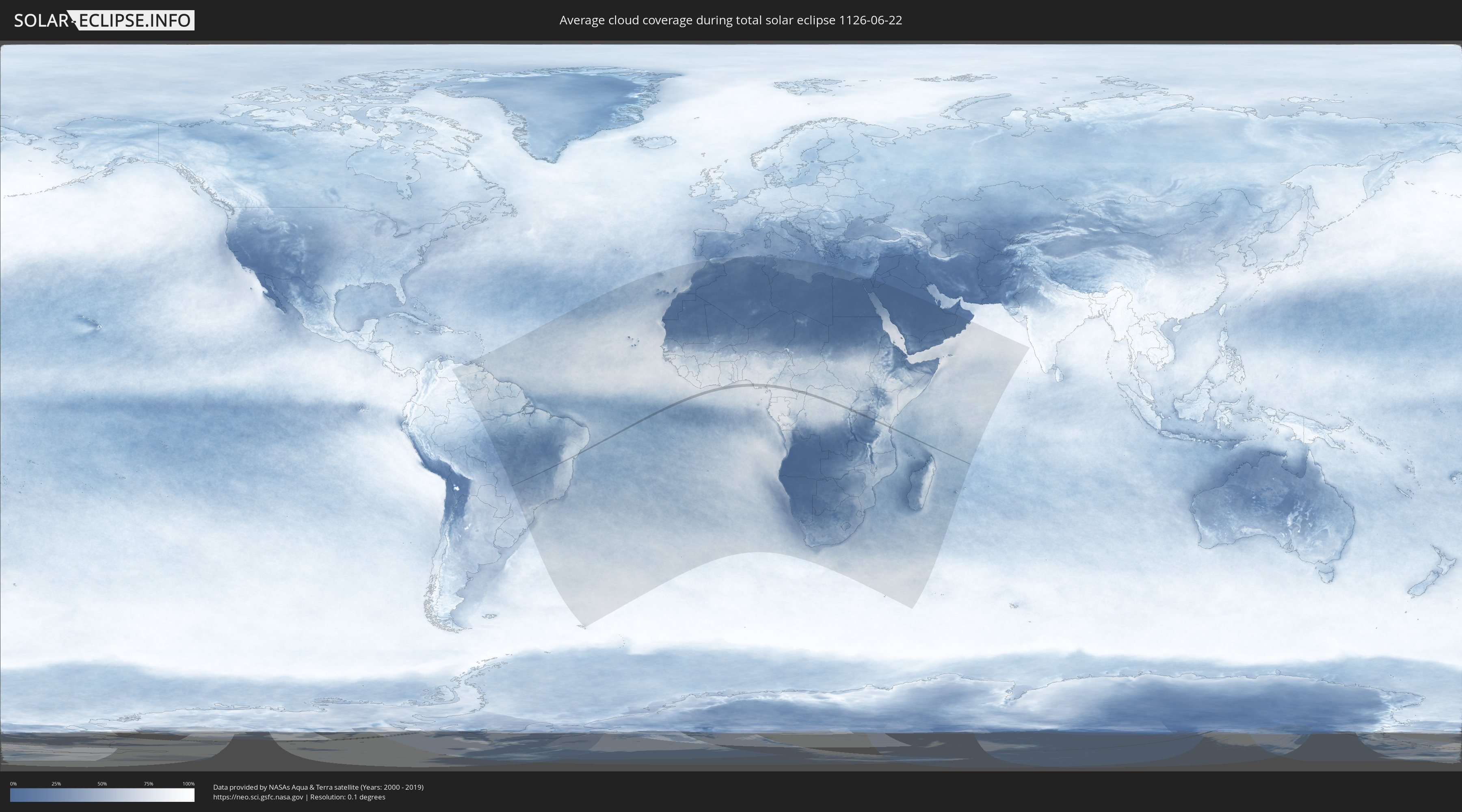
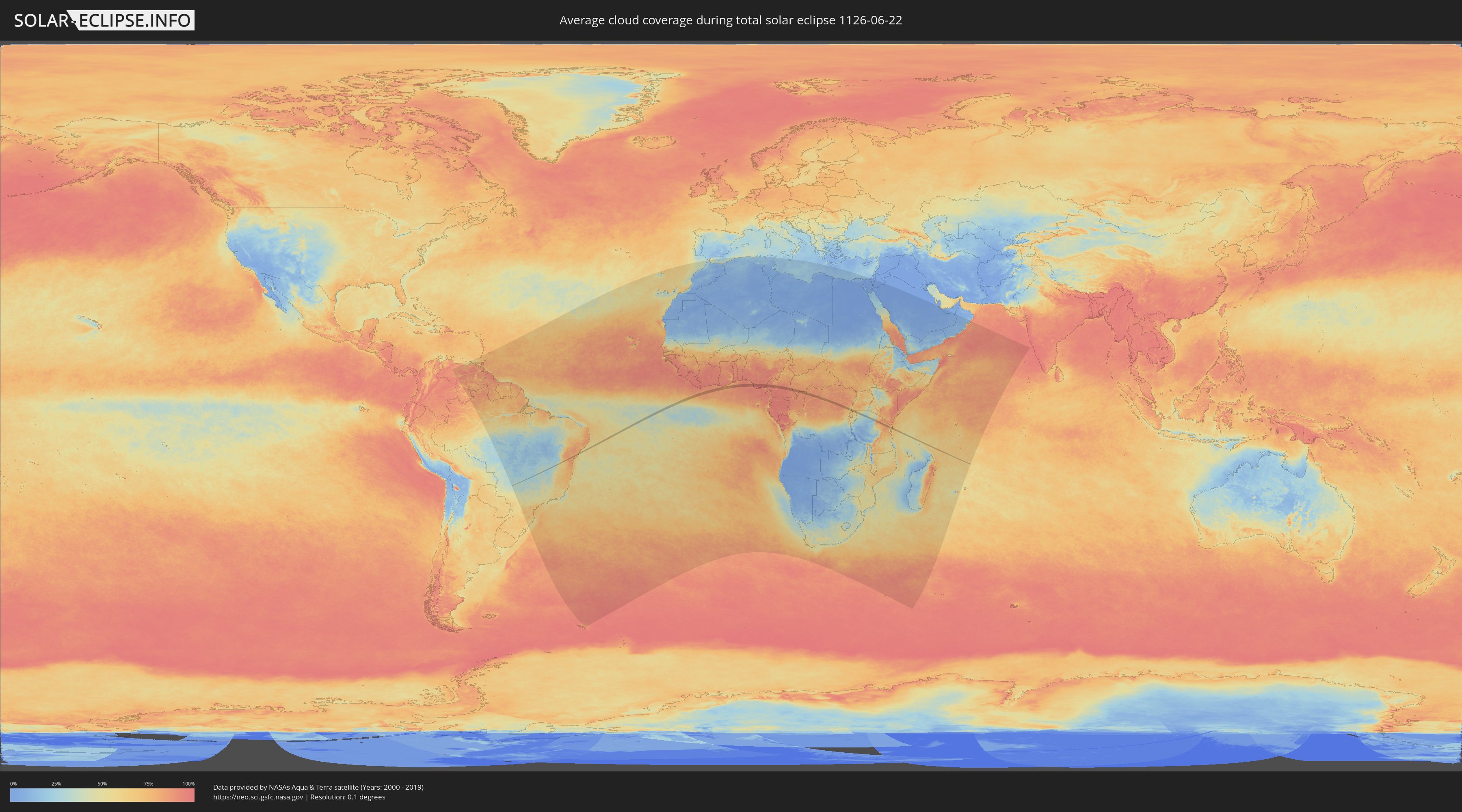
Wie wird das Wetter während der totalen Sonnenfinsternis am 22.06.1126?
Wo ist der beste Ort, um die totale Sonnenfinsternis vom 22.06.1126 zu beobachten?
Die folgenden Karten zeigen die durchschnittliche Bewölkung für den Tag, an dem die totale Sonnenfinsternis
stattfindet. Mit Hilfe der Karten lässt sich der Ort entlang des Finsternispfades eingrenzen,
der die besten Aussichen auf einen klaren wolkenfreien Himmel bietet.
Trotzdem muss man immer lokale Gegenenheiten beachten und sollte sich genau über das Wetter an seinem
gewählten Beobachtungsort informieren.
Die Daten stammen von den beiden NASA-Satelliten
AQUA und TERRA
und wurden über einen Zeitraum von 19 Jahren (2000 - 2019) gemittelt.
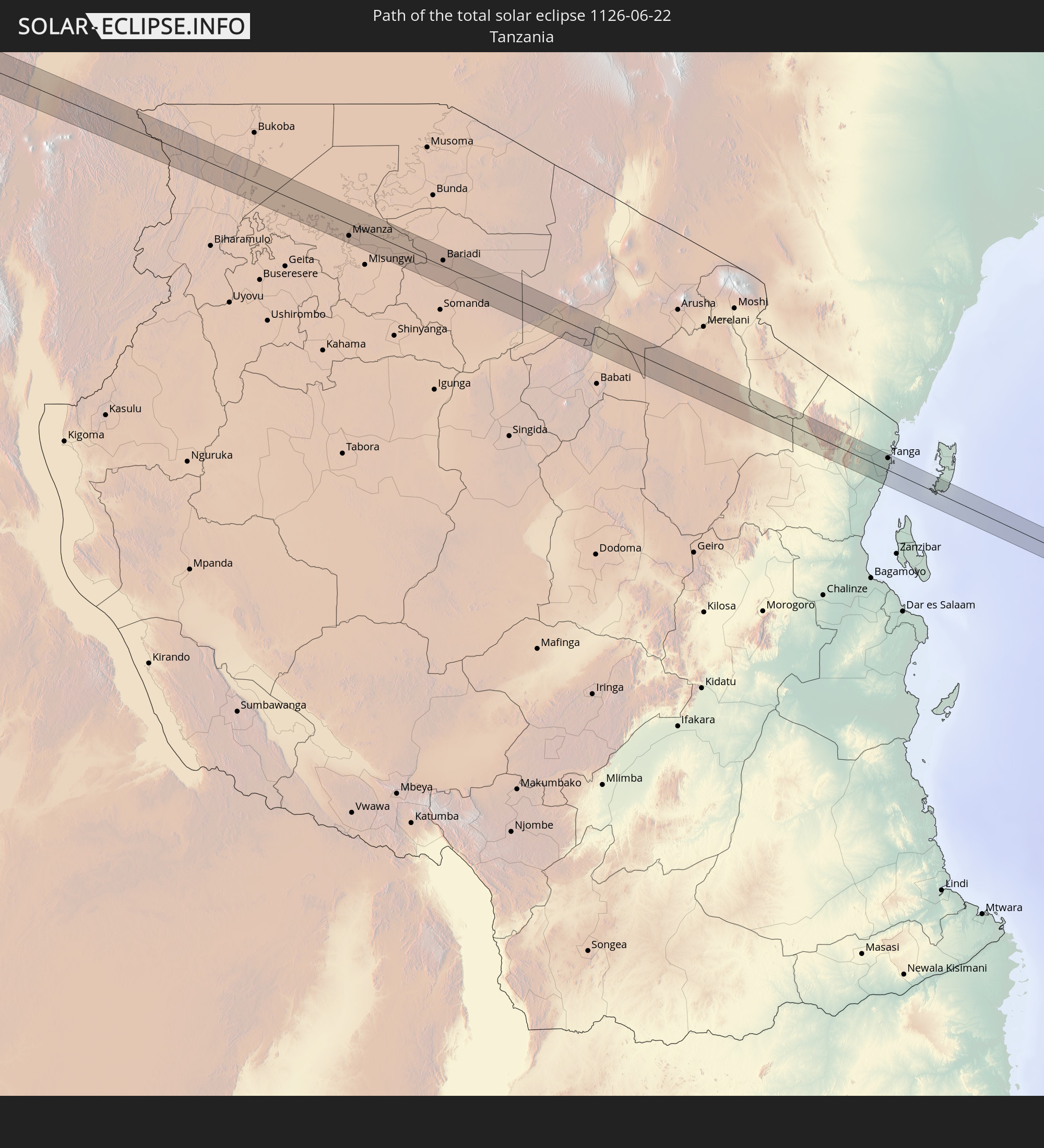
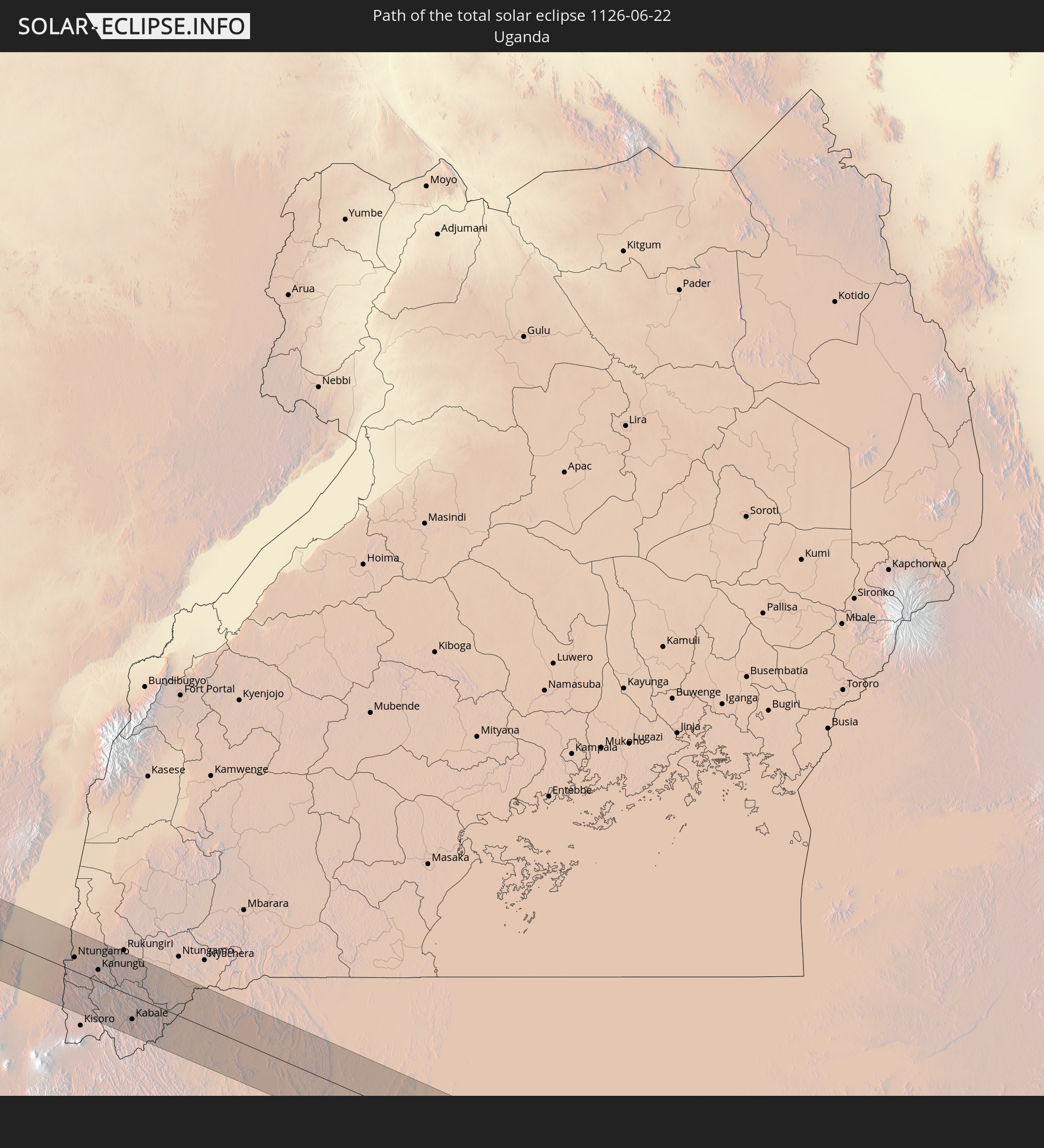
Detaillierte Länderkarten
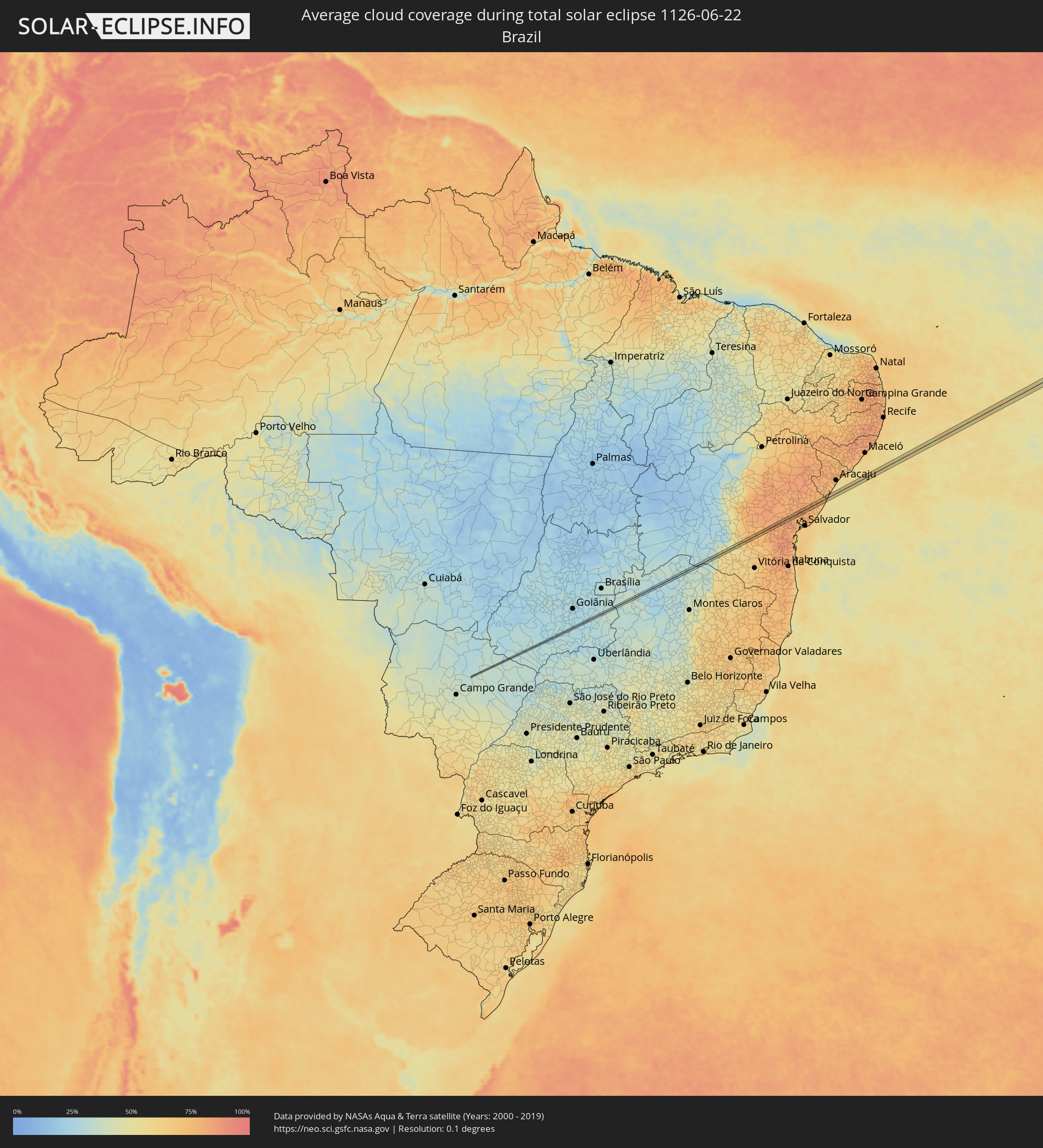 Brasilien
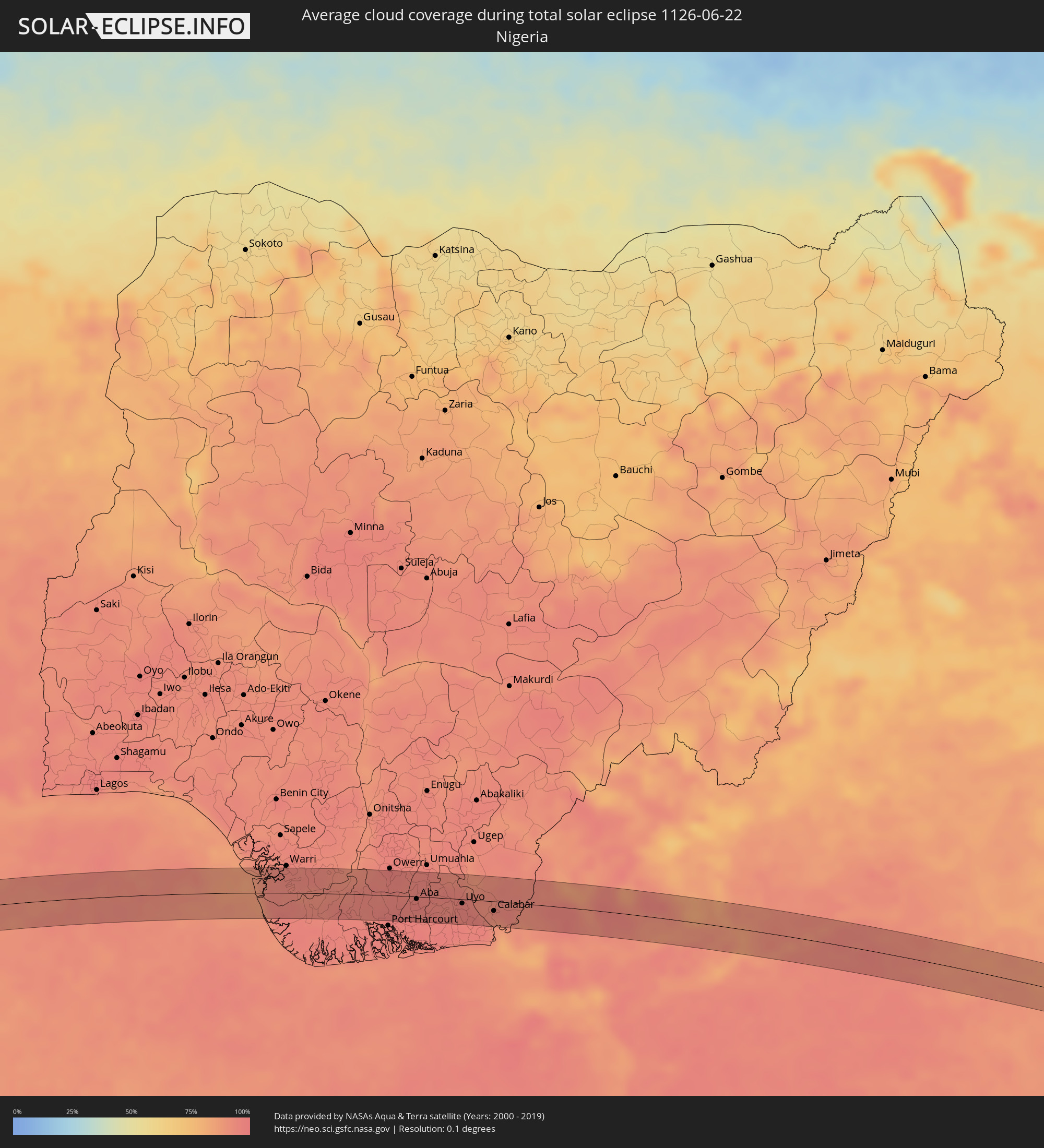 Nigeria
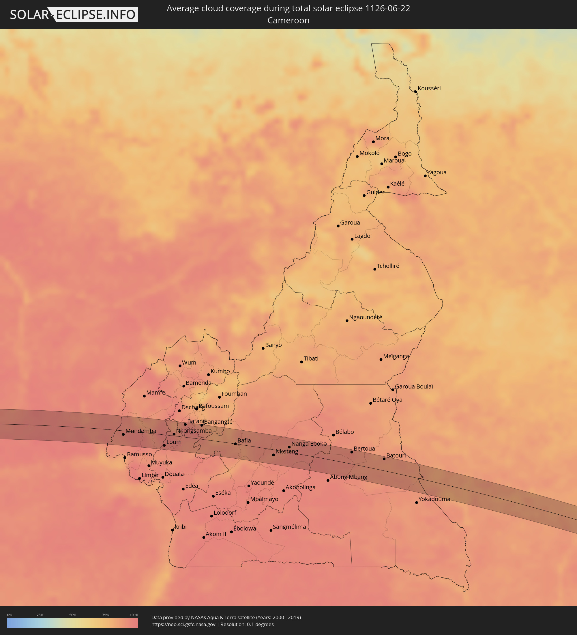 Kamerun
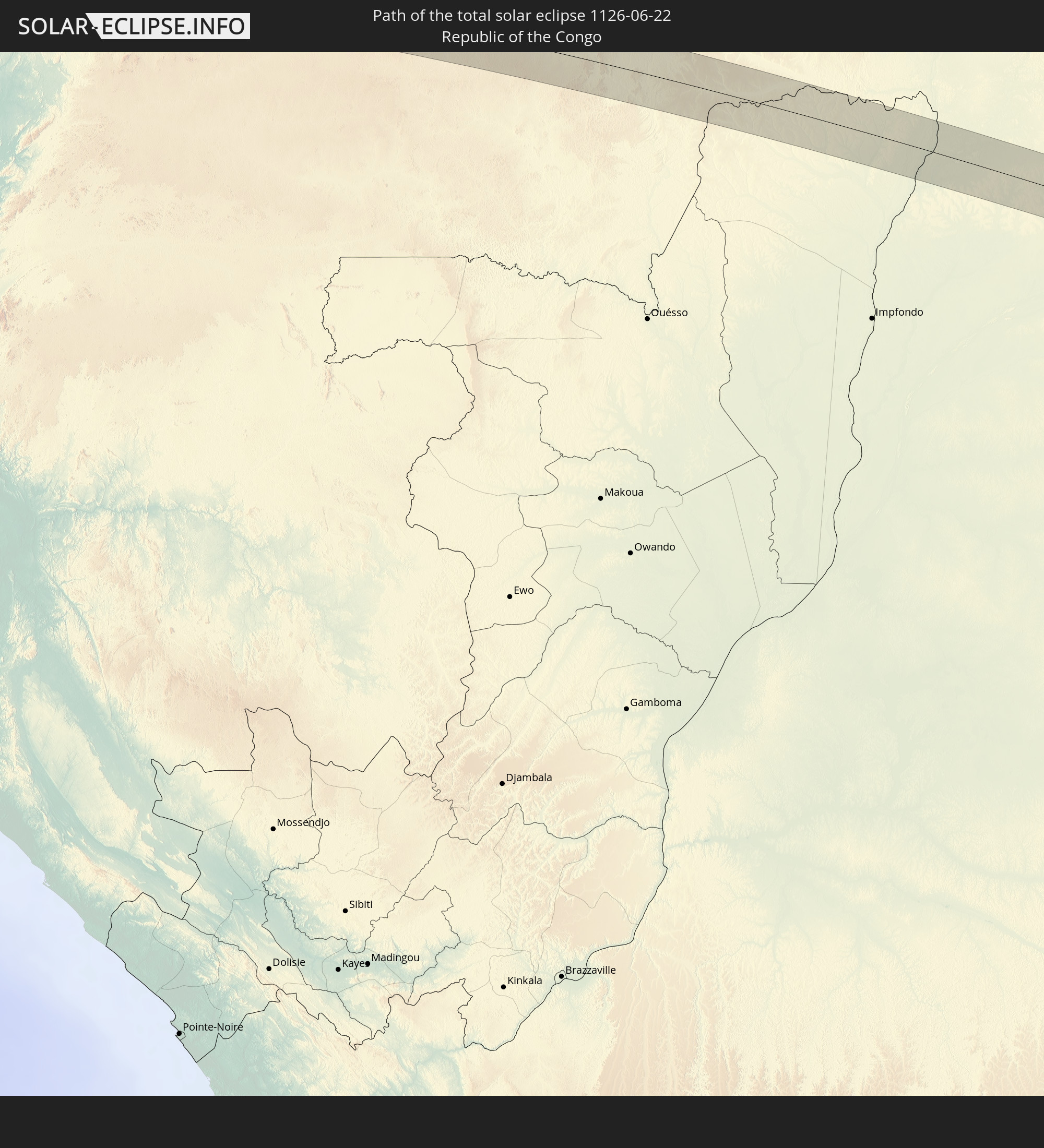
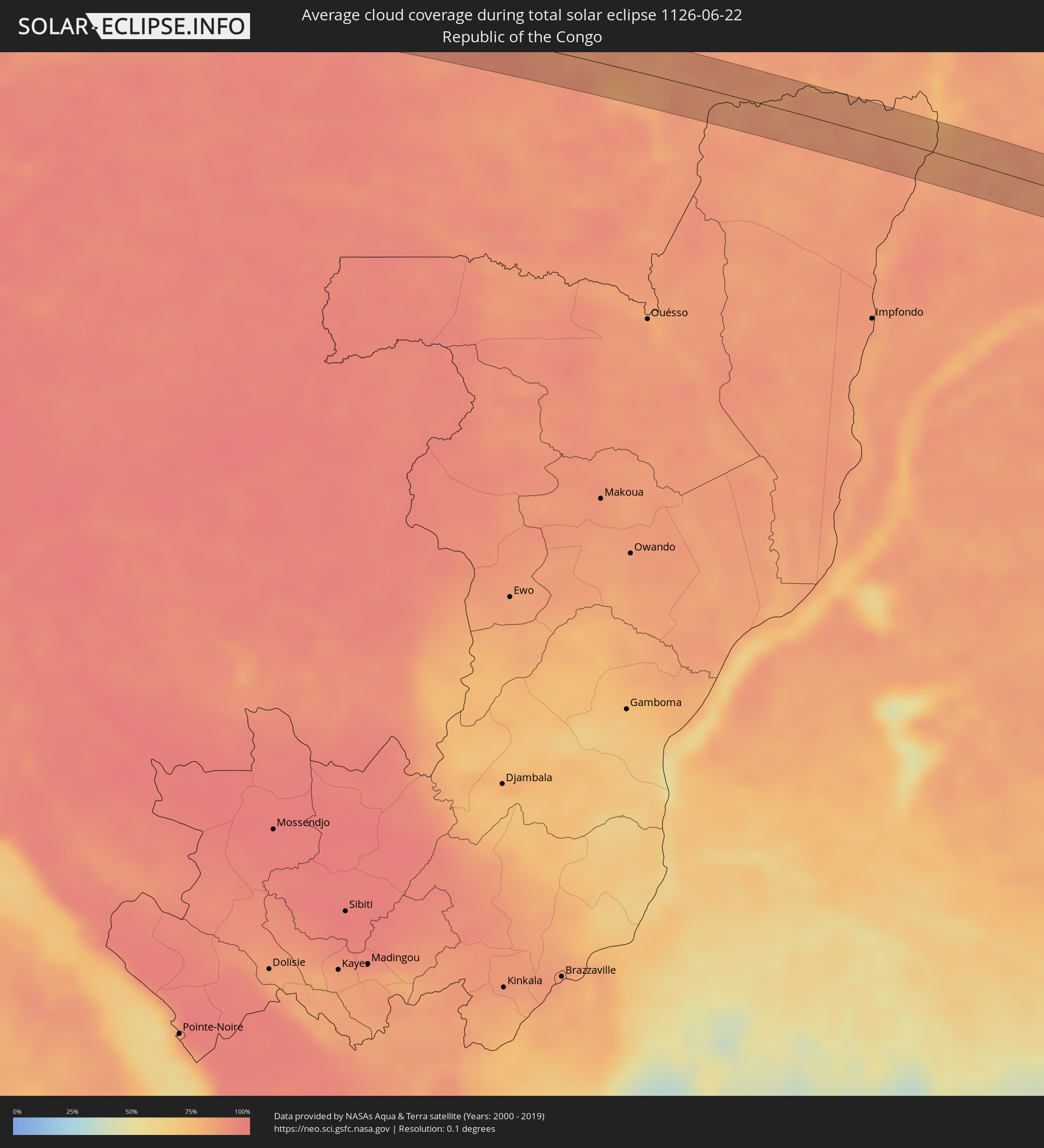 Republik Kongo
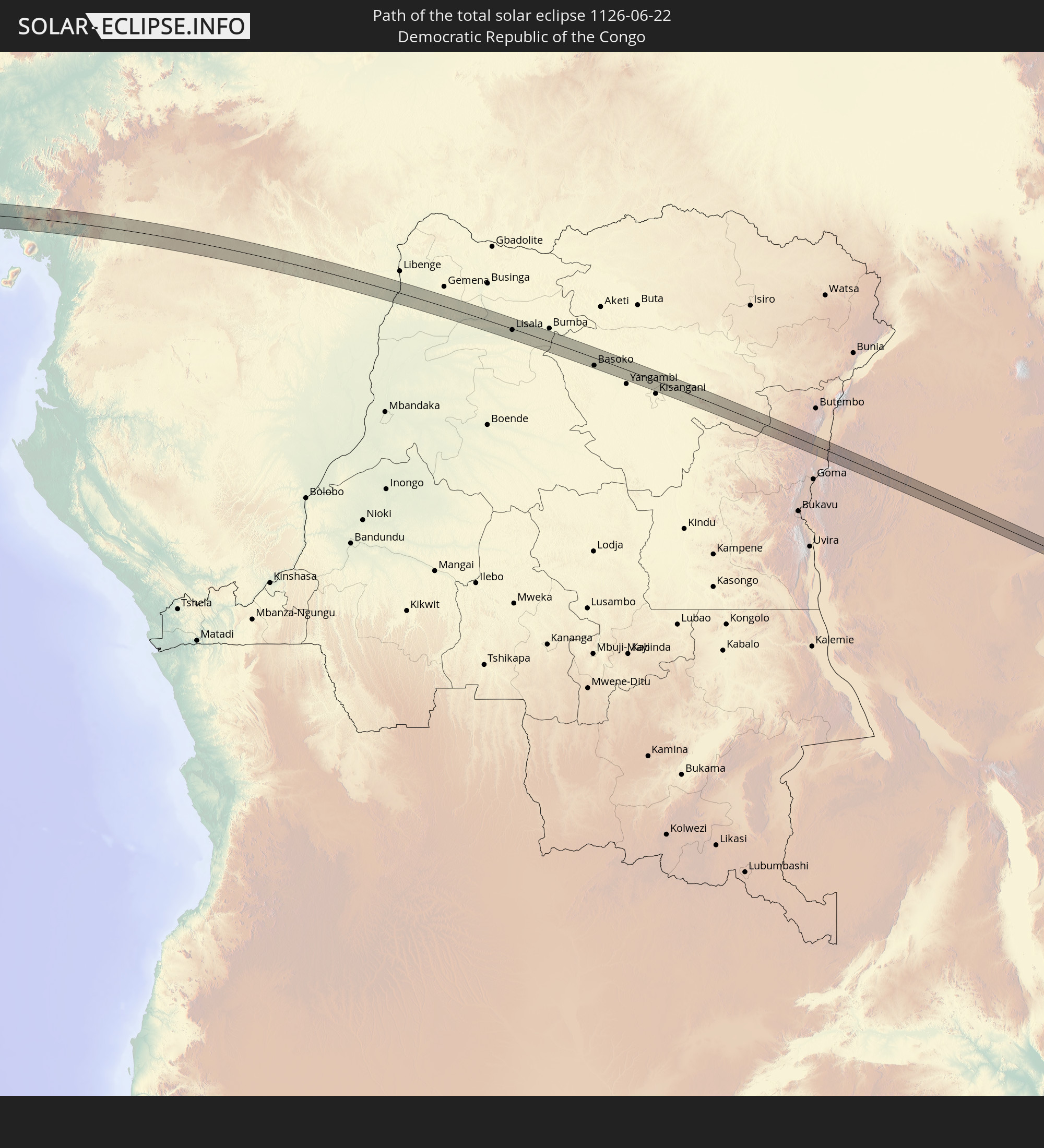
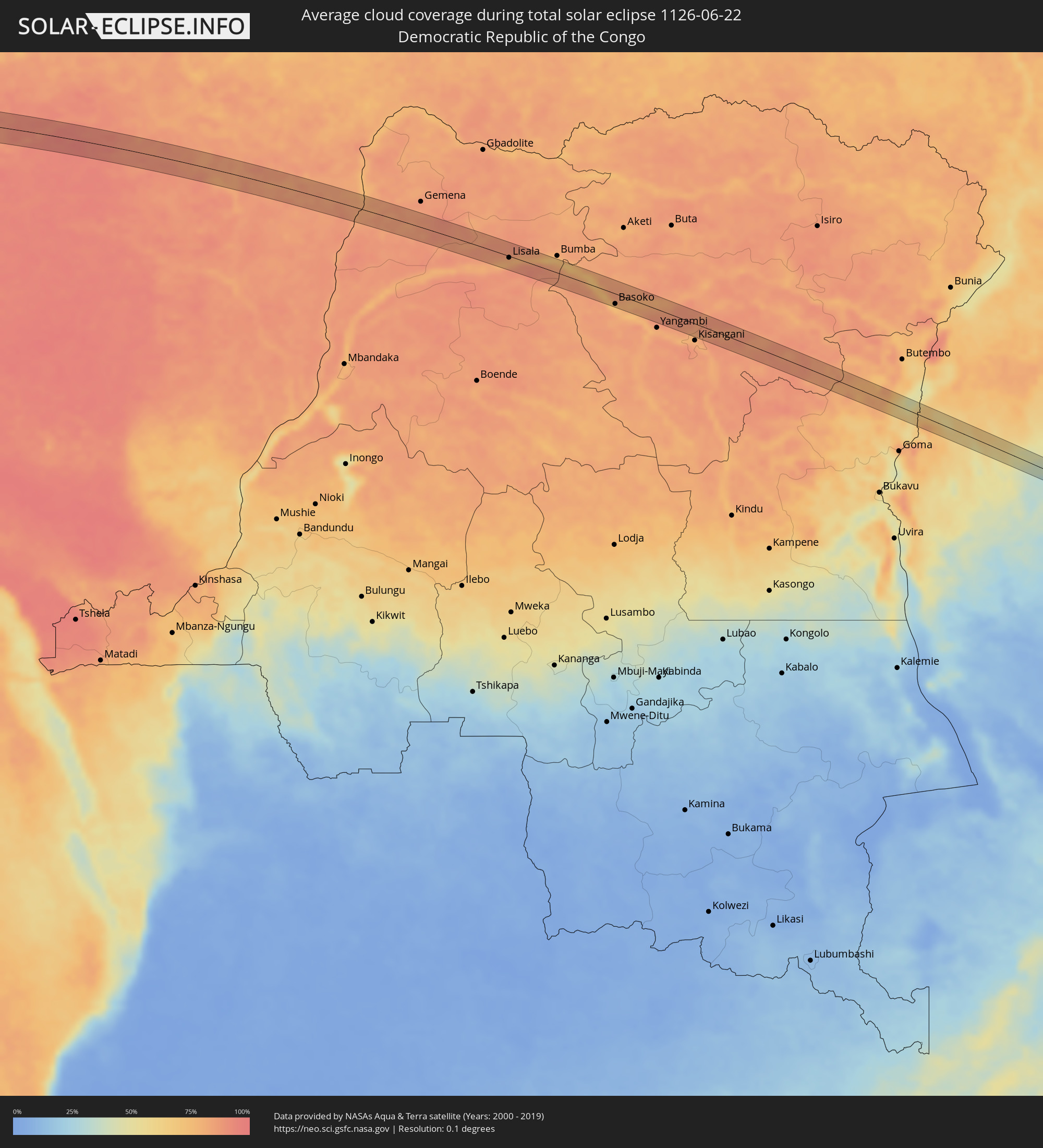 Demokratische Republik Kongo
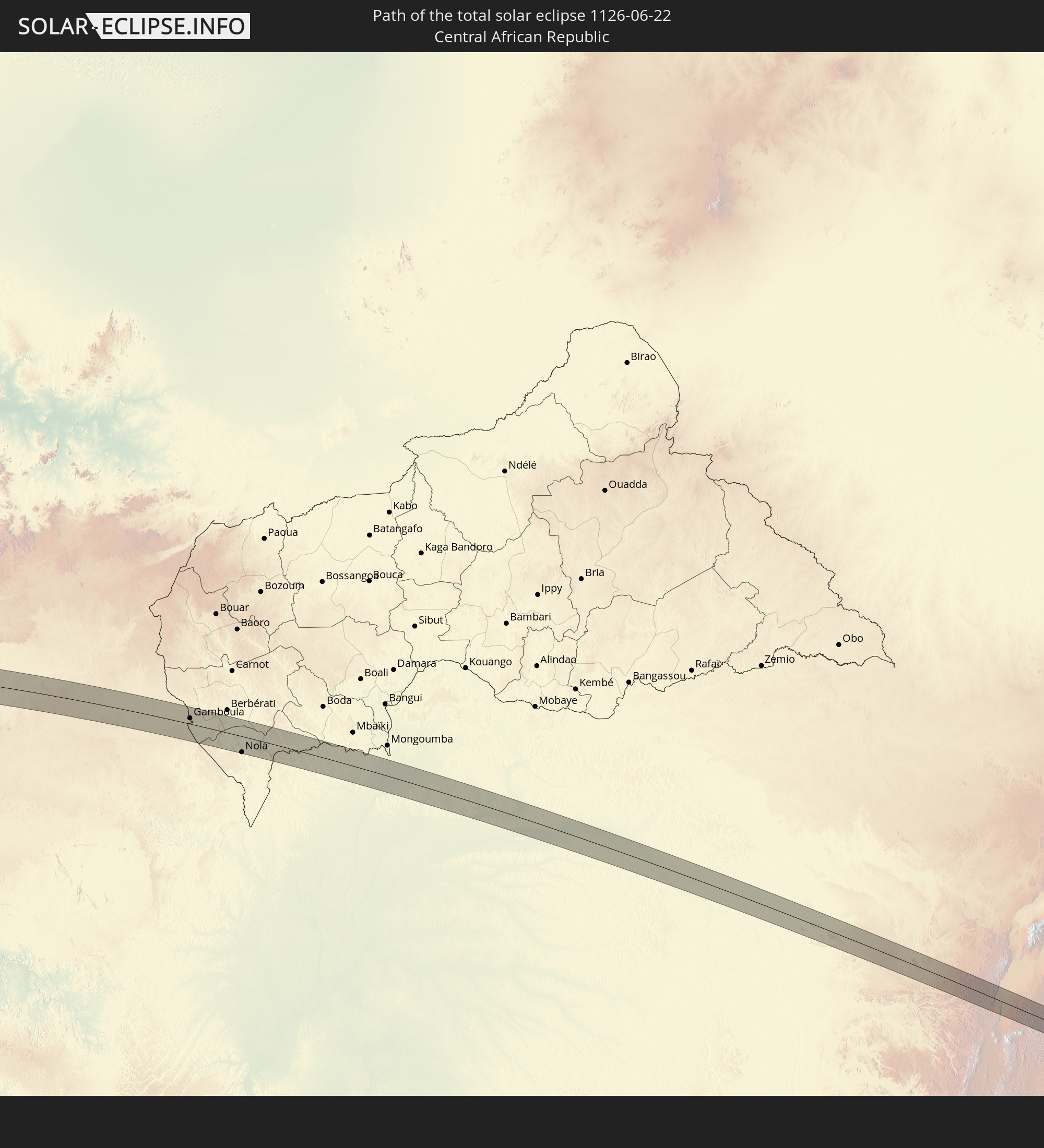
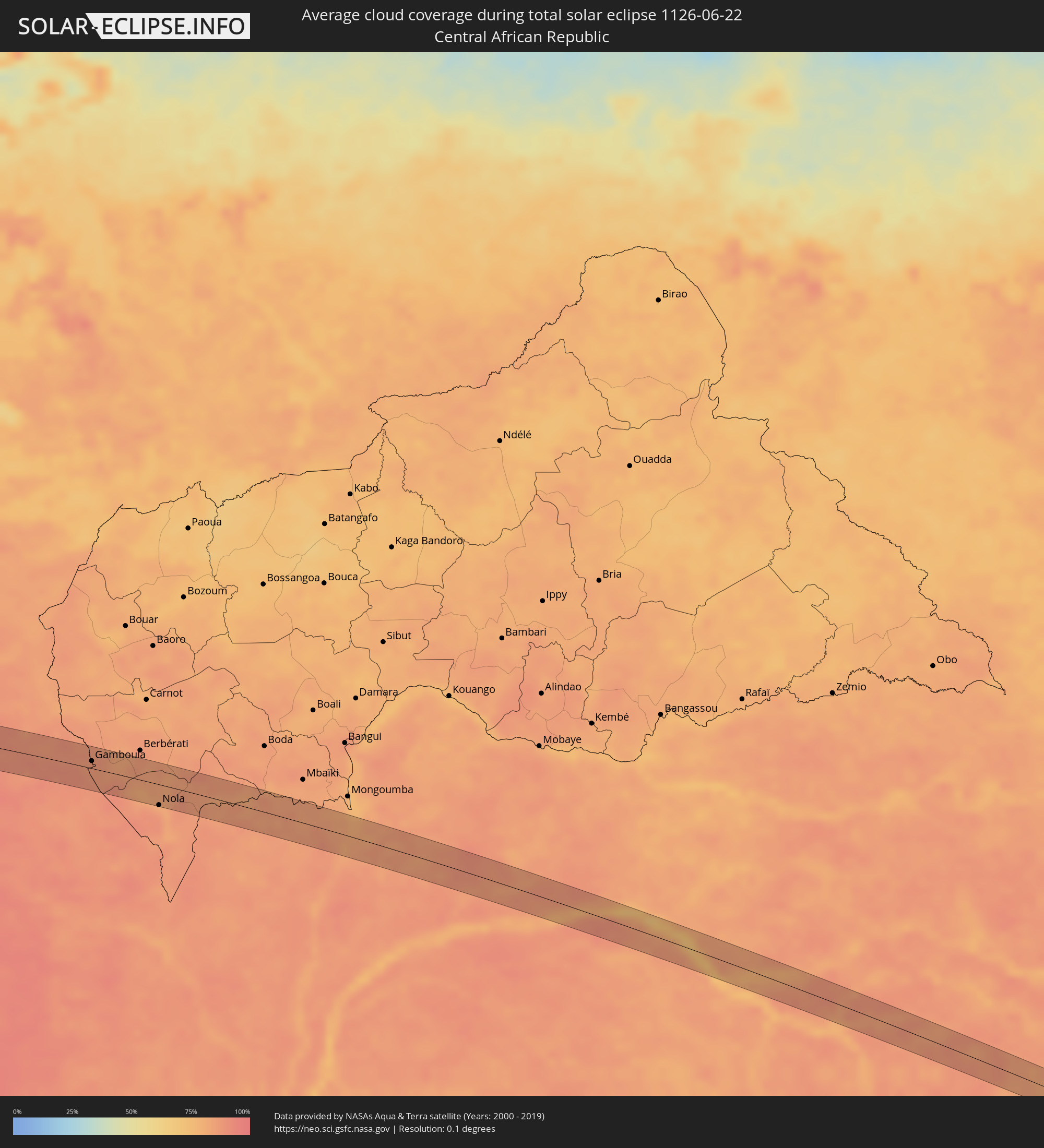 Zentralafrikanische Republik
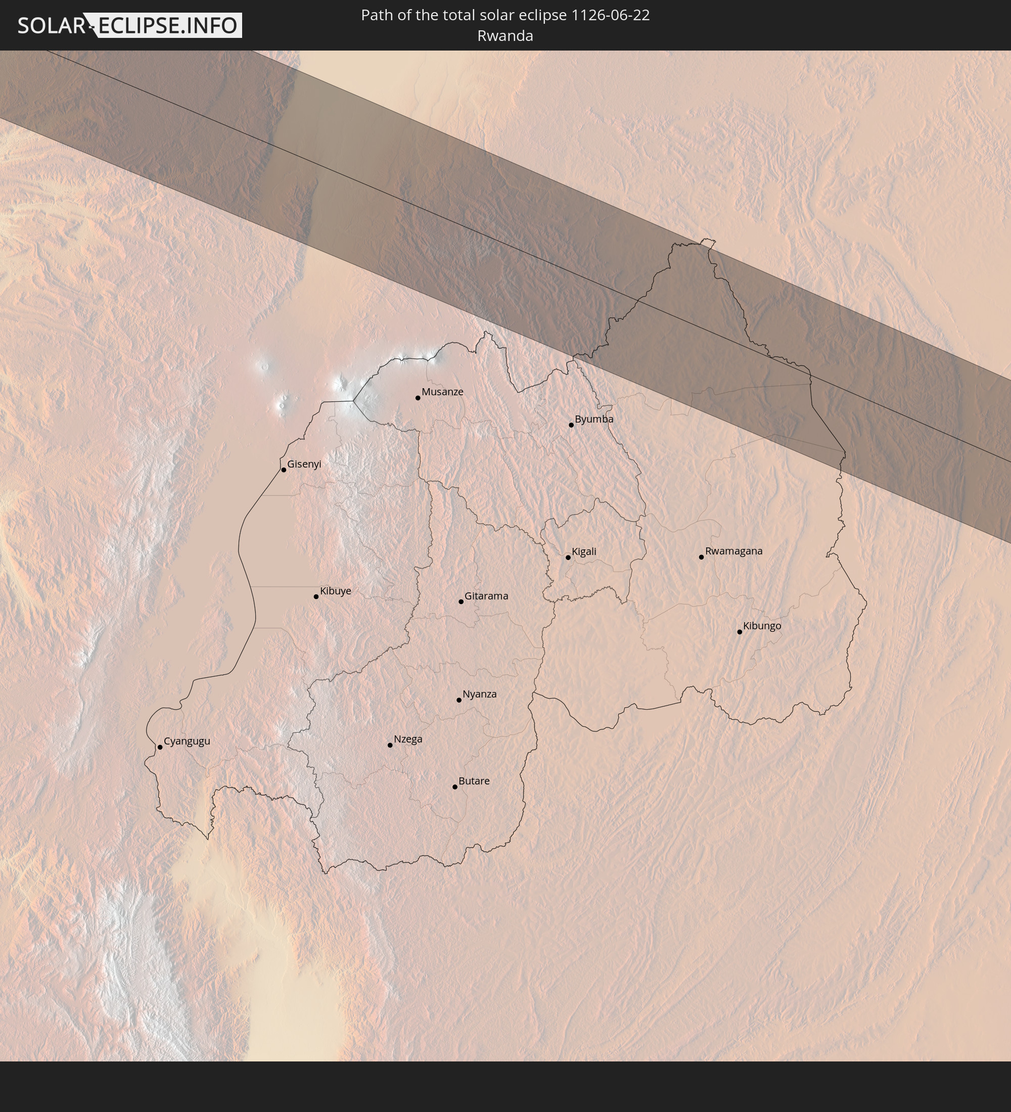
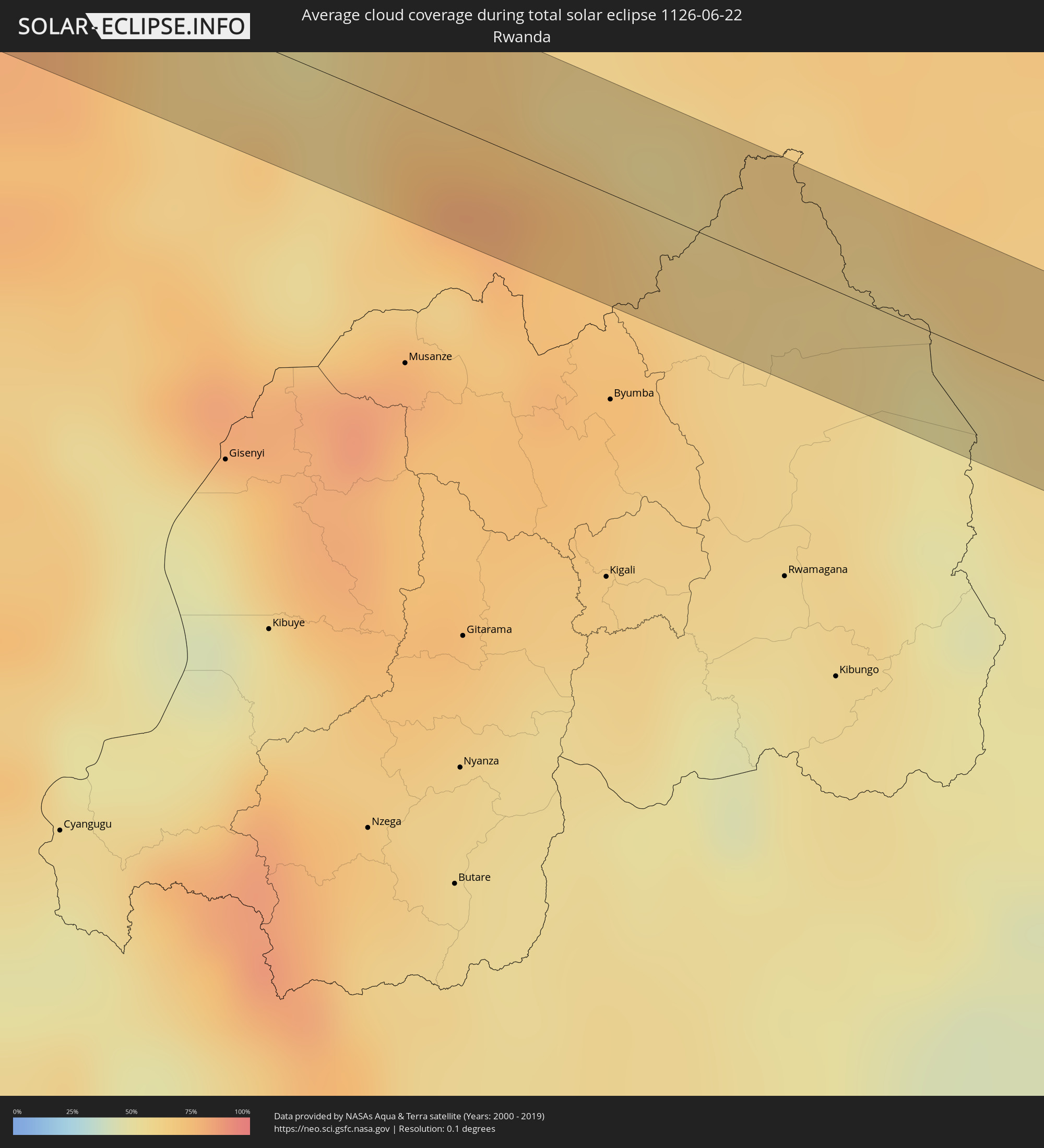 Ruanda
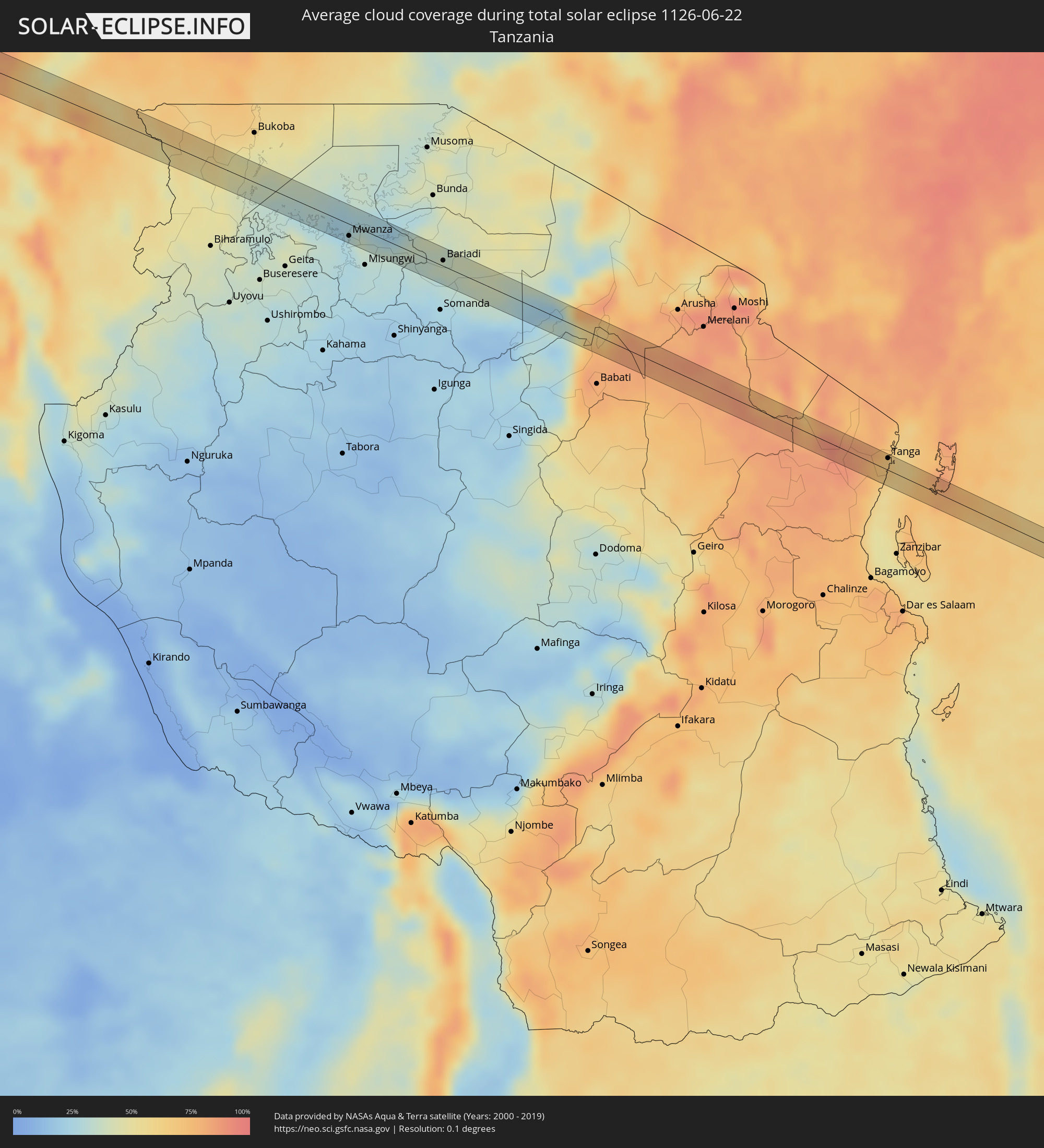 Tansania
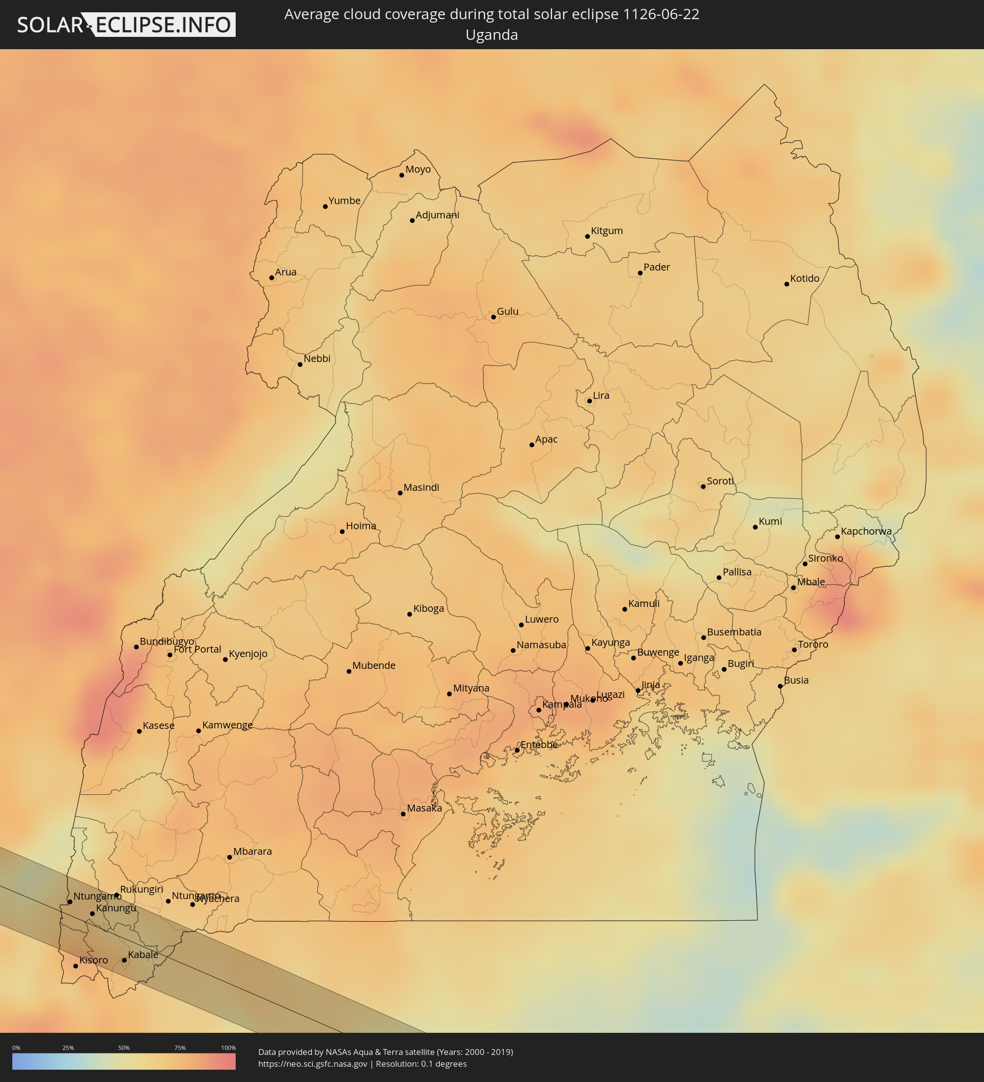 Uganda
Orte im Finsternispfad
Die nachfolgene Tabelle zeigt Städte und Orte mit mehr als 5.000 Einwohnern, die sich im Finsternispfad befinden. Städte mit mehr als 100.000 Einwohnern sind dick gekennzeichnet. Mit einem Klick auf den Ort öffnet sich eine Detailkarte die die Lage des jeweiligen Ortes zusammen mit dem Verlauf der zentralen Finsternis präsentiert.
| Ort | Typ | Dauer der Verfinsterung | Ortszeit bei maximaler Verfinsterung | Entfernung zur Zentrallinie | Ø Bewölkung |
|
Orizona, Goiás
|
total | - | 07:06:55 UTC-03:06 | 3 km | 30% |
|
Cristalina, Goiás
|
total | - | 07:07:06 UTC-03:06 | 3 km | 35% |
|
Unaí, Minas Gerais
|
total | - | 07:07:17 UTC-03:06 | 5 km | 34% |
|
Itacarambi, Minas Gerais
|
total | - | 07:08:22 UTC-03:06 | 6 km | 32% |
|
Barra da Estiva, Bahia
|
total | - | 07:42:17 UTC-02:34 | 4 km | 68% |
|
Castro Alves, Bahia
|
total | - | 07:43:33 UTC-02:34 | 6 km | 83% |
|
Cruz das Almas, Bahia
|
total | - | 07:43:47 UTC-02:34 | 13 km | 83% |
|
Conceição da Feira, Bahia
|
total | - | 07:43:52 UTC-02:34 | 2 km | 72% |
|
São Gonçalo dos Campos, Bahia
|
total | - | 07:43:54 UTC-02:34 | 4 km | 76% |
|
Cachoeira, Bahia
|
total | - | 07:43:53 UTC-02:34 | 13 km | 73% |
|
Conceição do Jacuípe, Bahia
|
total | - | 07:44:03 UTC-02:34 | 5 km | 81% |
|
Coração de Maria, Bahia
|
total | - | 07:44:05 UTC-02:34 | 12 km | 82% |
|
Alagoinhas, Bahia
|
total | - | 07:44:20 UTC-02:34 | 5 km | 80% |
|
Entre Rios, Bahia
|
total | - | 07:44:36 UTC-02:34 | 7 km | 80% |
|
Conde, Bahia
|
total | - | 07:44:59 UTC-02:34 | 4 km | 62% |
|
Burutu, Delta
|
total | - | 12:22:16 UTC+00:13 | 19 km | 92% |
|
Bomadi, Delta
|
total | - | 12:23:43 UTC+00:13 | 2 km | 91% |
|
Ughelli, Delta
|
total | - | 12:24:03 UTC+00:13 | 35 km | 95% |
|
Amassoma, Bayelsa
|
total | - | 12:24:22 UTC+00:13 | 23 km | 93% |
|
Patani, Delta
|
total | - | 12:24:41 UTC+00:13 | 6 km | 92% |
|
Yenagoa, Bayelsa
|
total | - | 12:24:55 UTC+00:13 | 27 km | 95% |
|
Ahoada, Rivers
|
total | - | 12:26:18 UTC+00:13 | 9 km | 95% |
|
Omoku, Rivers
|
total | - | 12:26:20 UTC+00:13 | 20 km | 94% |
|
Elele, Rivers
|
total | - | 12:26:53 UTC+00:13 | 6 km | 94% |
|
Aba, Abia
|
total | - | 12:28:50 UTC+00:13 | 3 km | 96% |
|
Ikot Ekpene, Akwa Ibom
|
total | - | 12:30:03 UTC+00:13 | 7 km | 96% |
|
Abak, Akwa Ibom
|
total | - | 12:30:18 UTC+00:13 | 14 km | 94% |
|
Etinan, Akwa Ibom
|
total | - | 12:30:32 UTC+00:13 | 30 km | 96% |
|
Arochukwu, Abia
|
total | - | 12:30:44 UTC+00:13 | 32 km | 92% |
|
Uyo, Akwa Ibom
|
total | - | 12:30:49 UTC+00:13 | 6 km | 96% |
|
Itu, Akwa Ibom
|
total | - | 12:30:59 UTC+00:13 | 11 km | 94% |
|
Akankpa, Cross River
|
total | - | 12:31:42 UTC+00:13 | 5 km | 92% |
|
Esuk Oron, Akwa Ibom
|
total | - | 12:31:56 UTC+00:13 | 31 km | 90% |
|
Calabar, Cross River
|
total | - | 12:32:11 UTC+00:13 | 13 km | 93% |
|
Ikang, Cross River
|
total | - | 12:32:54 UTC+00:13 | 30 km | 89% |
|
Mundemba, South-West
|
total | - | 12:34:04 UTC+00:13 | 9 km | 92% |
|
Bekondo, South-West
|
total | - | 12:35:38 UTC+00:13 | 34 km | 93% |
|
Loum, Littoral
|
total | - | 12:37:02 UTC+00:13 | 25 km | 93% |
|
Manjo, Littoral
|
total | - | 12:37:19 UTC+00:13 | 11 km | 94% |
|
Nkongsamba, Littoral
|
total | - | 12:37:43 UTC+00:13 | 3 km | 95% |
|
Melong, Littoral
|
total | - | 12:37:46 UTC+00:13 | 22 km | 90% |
|
Bafang, West
|
total | - | 12:38:30 UTC+00:13 | 29 km | 95% |
|
Bana, West
|
total | - | 12:38:50 UTC+00:13 | 29 km | 95% |
|
Bazou, West
|
total | - | 12:39:29 UTC+00:13 | 22 km | 92% |
|
Bangangté, West
|
total | - | 12:39:40 UTC+00:13 | 32 km | 92% |
|
Tonga, West
|
total | - | 12:40:16 UTC+00:13 | 15 km | 84% |
|
Ndikiniméki, Centre
|
total | - | 12:40:44 UTC+00:13 | 5 km | 90% |
|
Bafia, Centre
|
total | - | 12:42:04 UTC+00:13 | 1 km | 88% |
|
Ntui, Centre
|
total | - | 12:43:25 UTC+00:13 | 27 km | 90% |
|
Mbandjok, Centre
|
total | - | 12:44:18 UTC+00:13 | 23 km | 91% |
|
Nkoteng, Centre
|
total | - | 12:44:43 UTC+00:13 | 13 km | 92% |
|
Nanga Eboko, Centre
|
total | - | 12:45:46 UTC+00:13 | 12 km | 93% |
|
Doumé, East
|
total | - | 12:49:18 UTC+00:13 | 16 km | 94% |
|
Dimako, East
|
total | - | 12:49:38 UTC+00:13 | 3 km | 94% |
|
Bertoua, East
|
total | - | 12:49:57 UTC+00:13 | 27 km | 92% |
|
Batouri, East
|
total | - | 12:52:06 UTC+00:13 | 26 km | 87% |
|
Ndelele, East
|
total | - | 12:53:53 UTC+00:13 | 3 km | 90% |
|
Gamboula, Mambéré-Kadéï
|
total | - | 12:54:31 UTC+00:13 | 11 km | 86% |
|
Nola, Sangha-Mbaéré
|
total | - | 12:57:22 UTC+00:13 | 30 km | 87% |
|
Lisala, Équateur
|
total | - | 13:12:27 UTC+00:13 | 3 km | 81% |
|
Basoko, Orientale
|
total | - | 15:14:25 UTC+02:10 | 21 km | 76% |
|
Ntungamo, Western Region
|
total | - | 15:43:54 UTC+02:27 | 8 km | 75% |
|
Kanungu, Western Region
|
total | - | 15:44:10 UTC+02:27 | 7 km | 80% |
|
Kabale, Western Region
|
total | - | 15:44:35 UTC+02:27 | 14 km | 71% |
|
Bugene, Kagera
|
total | - | 15:46:34 UTC+02:27 | 2 km | 52% |
|
Nyakahanga, Kagera
|
total | - | 15:46:34 UTC+02:27 | 0 km | 52% |
|
Nshamba, Kagera
|
total | - | 15:47:16 UTC+02:27 | 1 km | 44% |
|
Kamachumu, Kagera
|
total | - | 15:47:20 UTC+02:27 | 20 km | 49% |
|
Muleba, Kagera
|
total | - | 15:47:27 UTC+02:27 | 1 km | 42% |
|
Mwanza, Mwanza
|
total | - | 15:49:29 UTC+02:27 | 14 km | 30% |
|
Nyanguge, Mwanza
|
total | - | 15:49:56 UTC+02:27 | 4 km | 34% |
|
Kihangara, Mwanza
|
total | - | 15:50:09 UTC+02:27 | 0 km | 33% |
|
Bariadi, Simiyu
|
total | - | 15:51:05 UTC+02:27 | 7 km | 38% |
|
Maswa, Simiyu
|
total | - | 15:51:03 UTC+02:27 | 18 km | 36% |
|
Kisesa, Simiyu
|
total | - | 15:51:23 UTC+02:27 | 15 km | 32% |
|
Naberera, Manyara
|
total | - | 15:55:07 UTC+02:27 | 1 km | 81% |
|
Hedaru, Kilimanjaro
|
total | - | 15:56:16 UTC+02:27 | 15 km | 80% |
|
Makuyuni, Tanga
|
total | - | 15:56:31 UTC+02:27 | 1 km | 78% |
|
Mwanga, Tanga
|
total | - | 15:56:38 UTC+02:27 | 1 km | 82% |
|
Mazinde, Tanga
|
total | - | 15:56:39 UTC+02:27 | 0 km | 82% |
|
Matui, Tanga
|
total | - | 15:56:41 UTC+02:27 | 1 km | 88% |
|
Lushoto, Tanga
|
total | - | 15:56:43 UTC+02:27 | 4 km | 88% |
|
Soni, Tanga
|
total | - | 15:56:49 UTC+02:27 | 2 km | 90% |
|
Maramba, Tanga
|
total | - | 15:57:07 UTC+02:27 | 7 km | 88% |
|
Muheza, Tanga
|
total | - | 15:57:19 UTC+02:27 | 11 km | 78% |
|
Majengo, Tanga
|
total | - | 15:57:31 UTC+02:27 | 0 km | 65% |
|
Tanga, Tanga
|
total | - | 15:57:37 UTC+02:27 | 14 km | 66% |
|
Mtambile, Pemba South
|
total | - | 15:58:16 UTC+02:27 | 10 km | 77% |