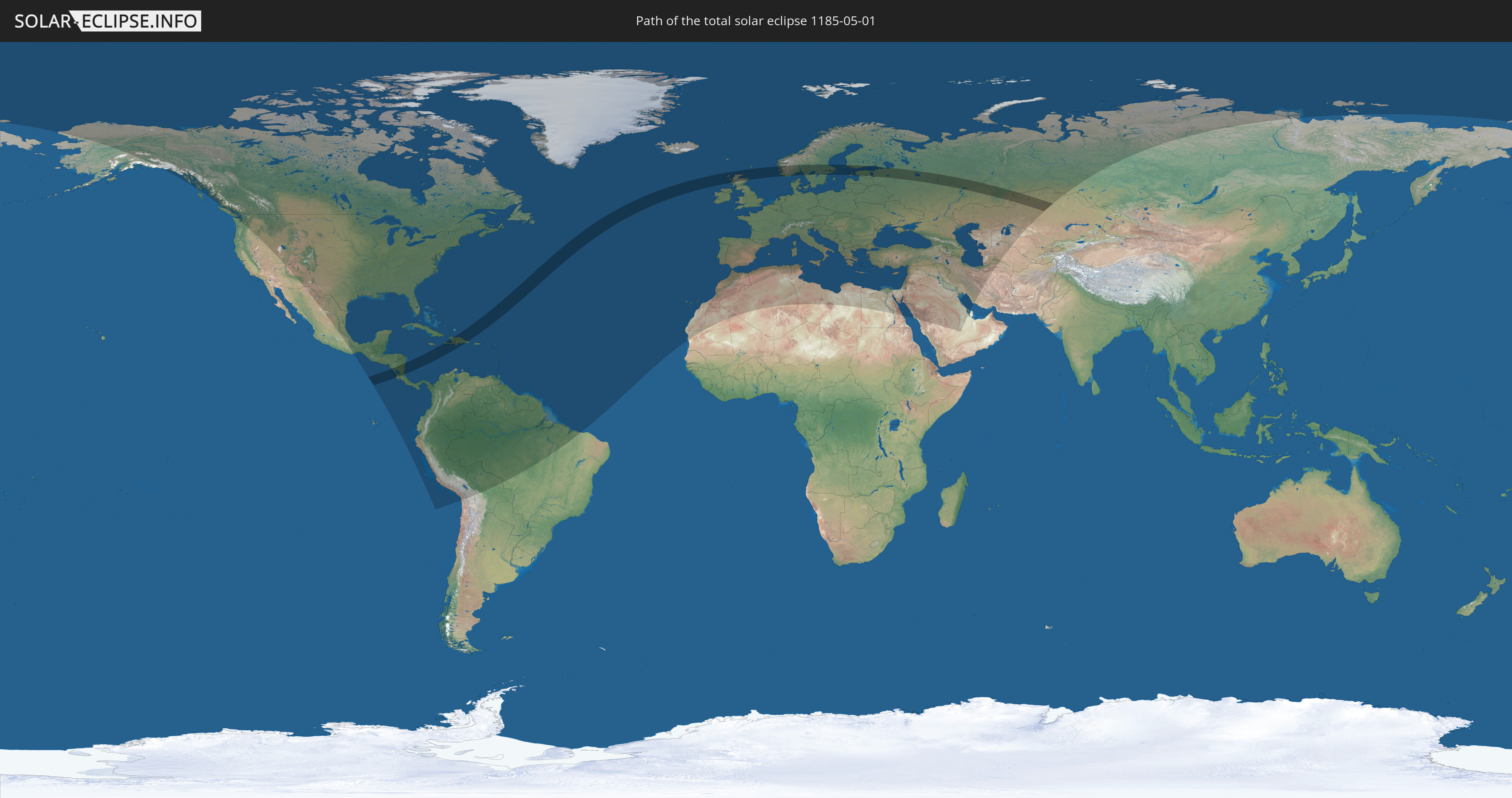
Totale Sonnenfinsternis vom 01.05.1185
| Wochentag: | Mittwoch |
| Maximale Dauer der Verfinsterung: | 05m10s |
| Maximale Breite des Finsternispfades: | 280 km |
| Saroszyklus: | 115 |
| Bedeckungsgrad: | 100% |
| Magnitude: | 1.0736 |
| Gamma: | 0.5264 |
Wo kann man die Sonnenfinsternis vom 01.05.1185 sehen?
Die Sonnenfinsternis am 01.05.1185 kann man in 126 Ländern als partielle Sonnenfinsternis beobachten.
Der Finsternispfad verläuft durch 13 Länder. Nur in diesen Ländern ist sie als totale Sonnenfinsternis zu sehen.
In den folgenden Ländern ist die Sonnenfinsternis total zu sehen
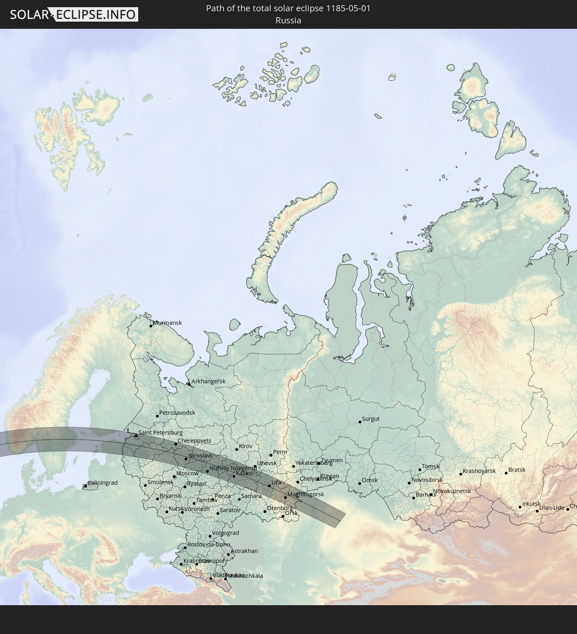 Russland
 Nicaragua
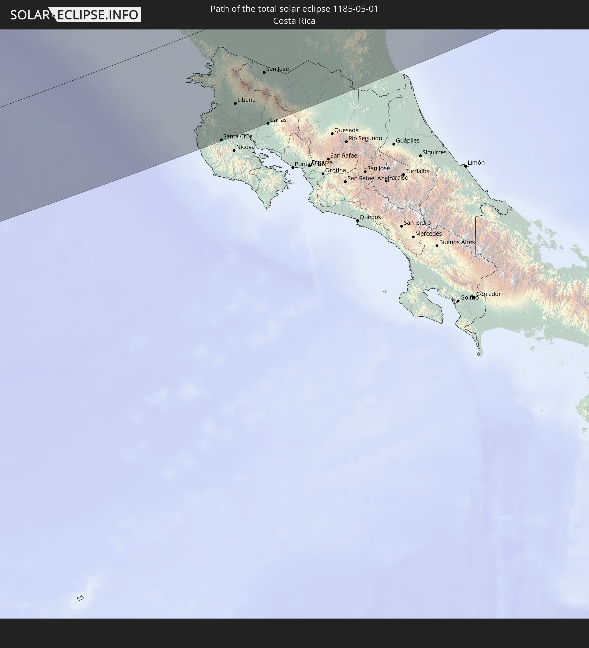 Costa Rica
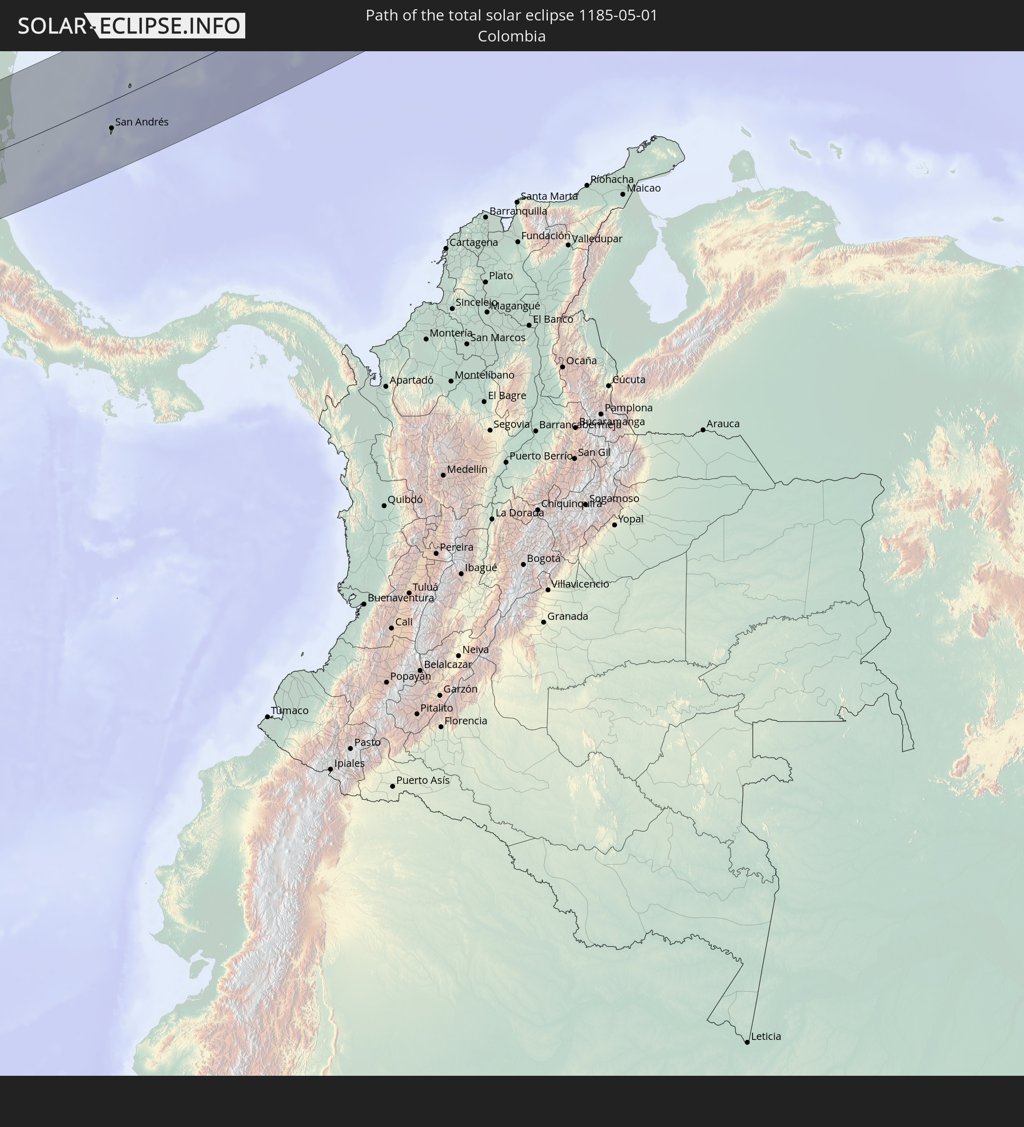 Kolumbien
 Haiti
Haiti
 Dominikanische Republik
 Vereinigtes Königreich
 Norwegen
 Schweden
 Åland Islands
 Finnland
 Estland
 Kasachstan
In den folgenden Ländern ist die Sonnenfinsternis partiell zu sehen
 Russland
 Vereinigte Staaten
 United States Minor Outlying Islands
 Kanada
 Mexiko
 Chile
Chile
 Grönland
 Guatemala
 Ecuador
 El Salvador
 Honduras
 Belize
 Nicaragua
 Costa Rica
 Kuba
Kuba
 Panama
 Kolumbien
 Kaimaninseln
 Peru
Peru
 Bahamas
 Jamaika
 Haiti
Haiti
 Brasilien
 Venezuela
 Turks- und Caicosinseln
 Dominikanische Republik
 Aruba
Aruba
 Bolivien
 Puerto Rico
 Amerikanische Jungferninseln
 Bermuda
 Britische Jungferninseln
 Anguilla
 Saint-Martin
 Saint-Barthélemy
 St. Kitts und Nevis
 Antigua und Barbuda
 Montserrat
 Trinidad und Tobago
 Guadeloupe
 Grenada
 Dominica
 St. Vincent und die Grenadinen
 Guyana
 Martinique
 St. Lucia
 Barbados
 Suriname
 Saint-Pierre und Miquelon
 Französisch-Guayana
 Portugal
 Kap Verde
 Island
 Spanien
 Mauretanien
 Marokko
 Mali
Mali
 Irland
 Spitzbergen
 Algerien
 Vereinigtes Königreich
 Färöer
 Gibraltar
 Frankreich
 Isle of Man
 Guernsey
 Jersey
 Andorra
 Belgien
 Niederlande
 Norwegen
 Luxemburg
 Deutschland
 Schweiz
 Italien
 Monaco
 Tunesien
 Dänemark
 Libyen
 Liechtenstein
 Österreich
 Schweden
 Tschechien
 San Marino
 Vatikanstadt
 Slowenien
 Kroatien
 Polen
Polen
 Malta
Malta
 Bosnien und Herzegowina
 Ungarn
 Slowakei
 Montenegro
 Serbien
 Albanien
 Åland Islands
 Griechenland
 Rumänien
 Mazedonien
 Finnland
 Litauen
 Lettland
 Estland
 Ukraine
 Bulgarien
 Weißrussland
 Ägypten
 Türkei
 Moldawien
 Republik Zypern
 Staat Palästina
 Israel
 Saudi-Arabien
 Jordanien
 Libanon
 Syrien
 Irak
Irak
 Georgien
 Armenien
 Iran
Iran
 Aserbaidschan
 Kasachstan
 Kuwait
 Bahrain
 Turkmenistan
 Usbekistan
Wie wird das Wetter während der totalen Sonnenfinsternis am 01.05.1185?
Wo ist der beste Ort, um die totale Sonnenfinsternis vom 01.05.1185 zu beobachten?
Die folgenden Karten zeigen die durchschnittliche Bewölkung für den Tag, an dem die totale Sonnenfinsternis
stattfindet. Mit Hilfe der Karten lässt sich der Ort entlang des Finsternispfades eingrenzen,
der die besten Aussichen auf einen klaren wolkenfreien Himmel bietet.
Trotzdem muss man immer lokale Gegenenheiten beachten und sollte sich genau über das Wetter an seinem
gewählten Beobachtungsort informieren.
Die Daten stammen von den beiden NASA-Satelliten
AQUA und TERRA
und wurden über einen Zeitraum von 19 Jahren (2000 - 2019) gemittelt.
Detaillierte Länderkarten
 Russland
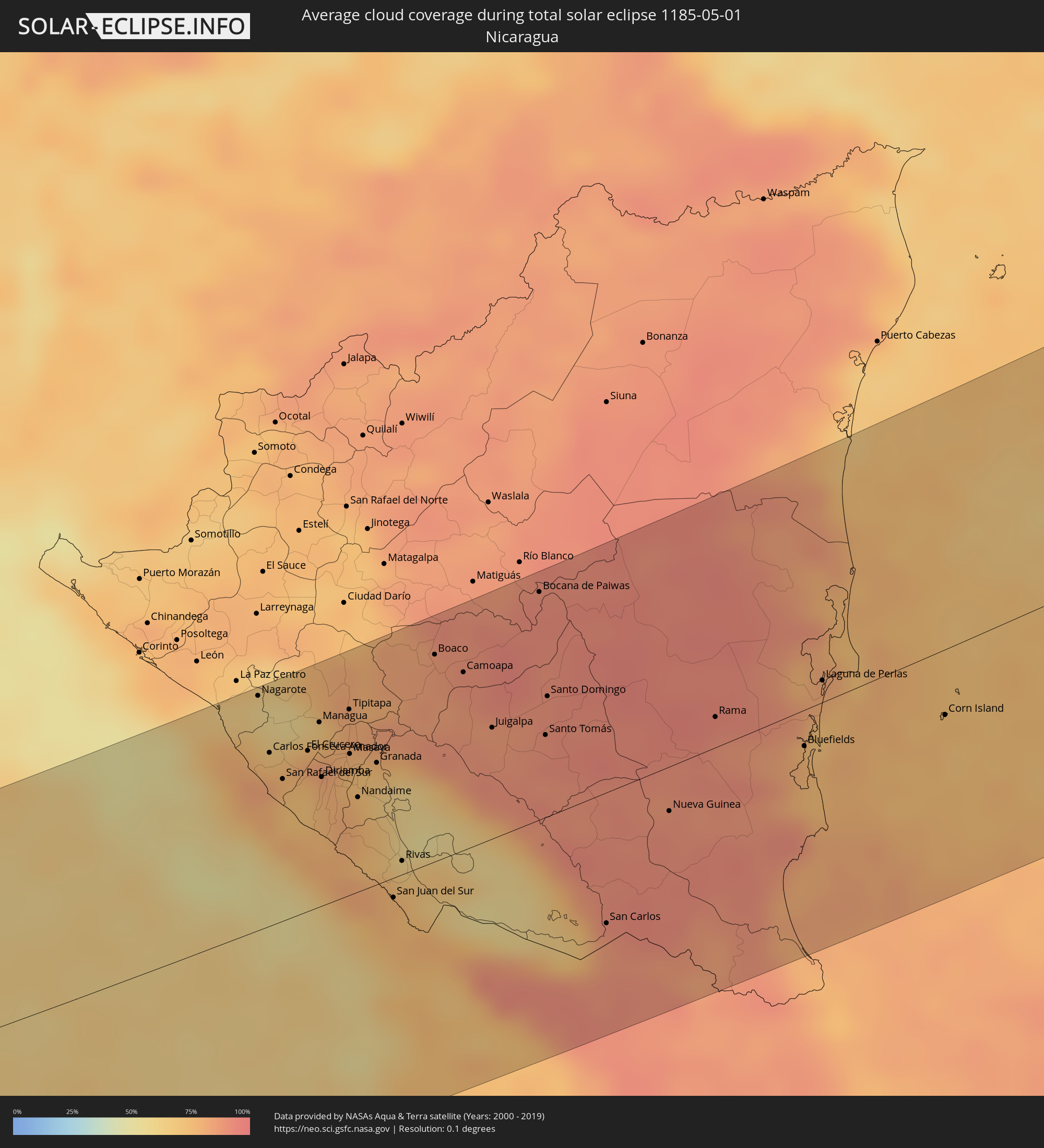 Nicaragua
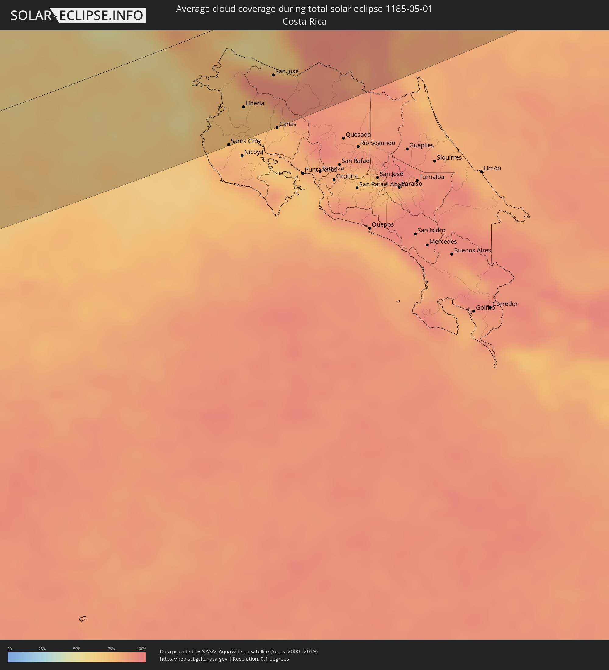 Costa Rica
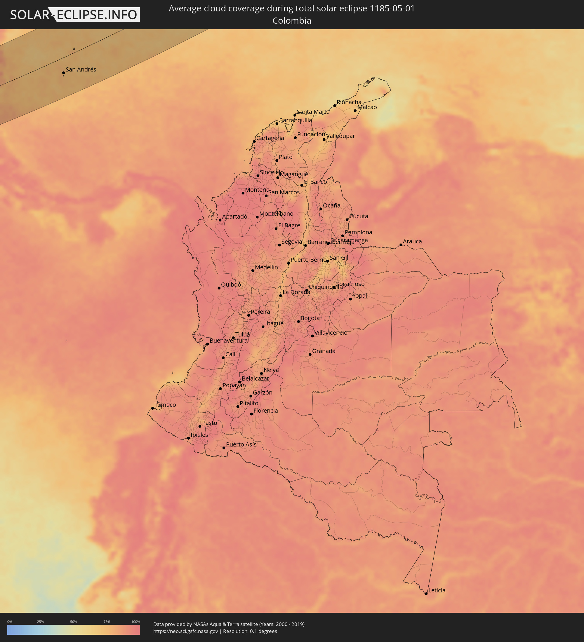 Kolumbien
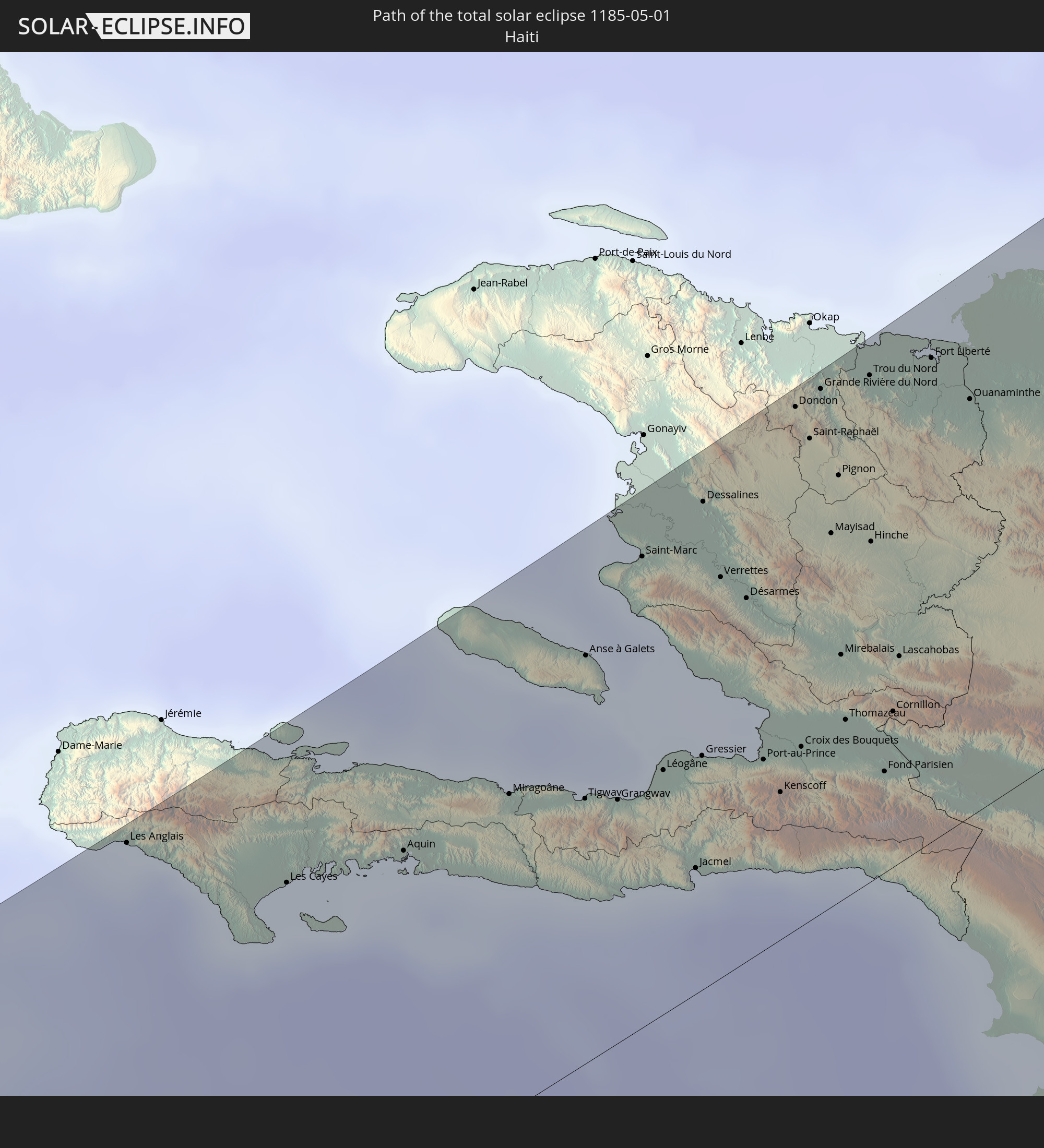
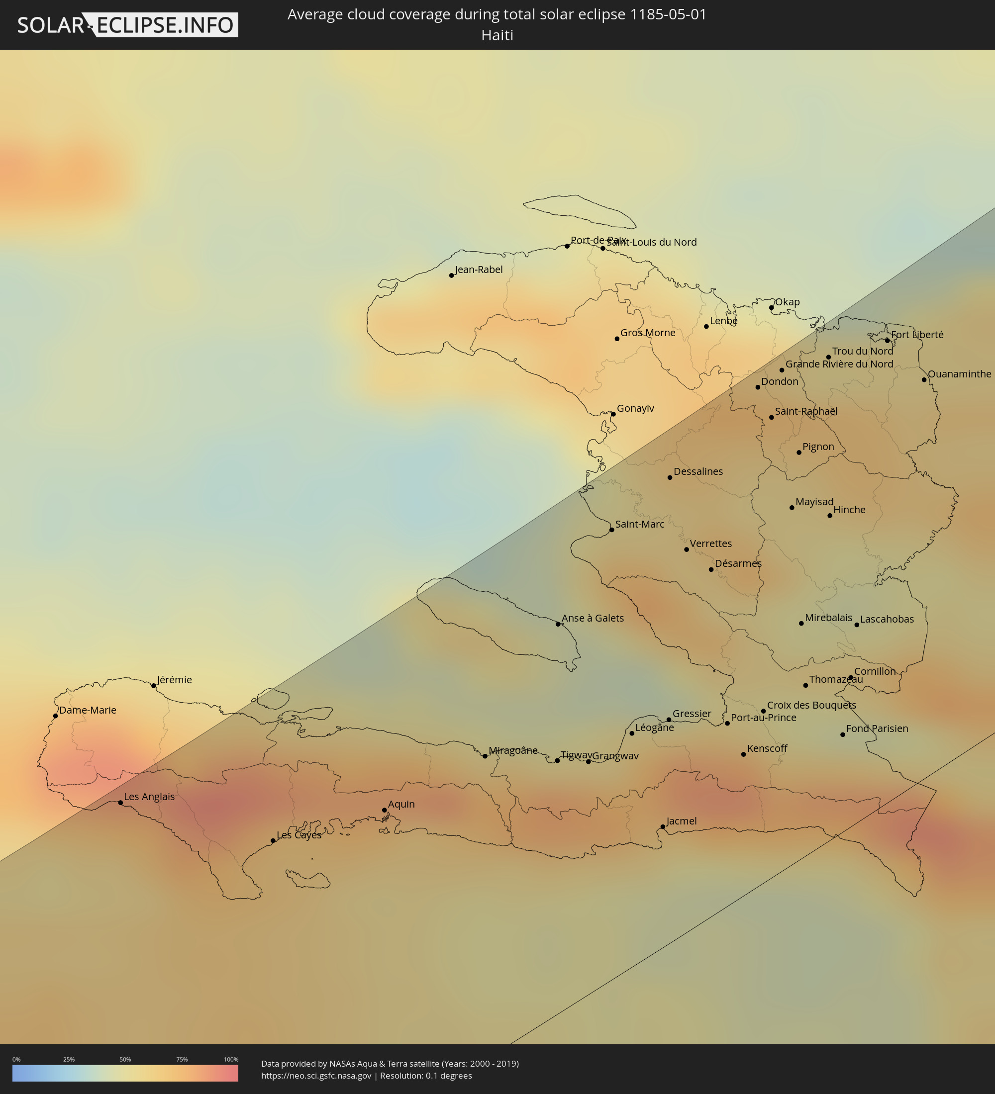 Haiti
Haiti
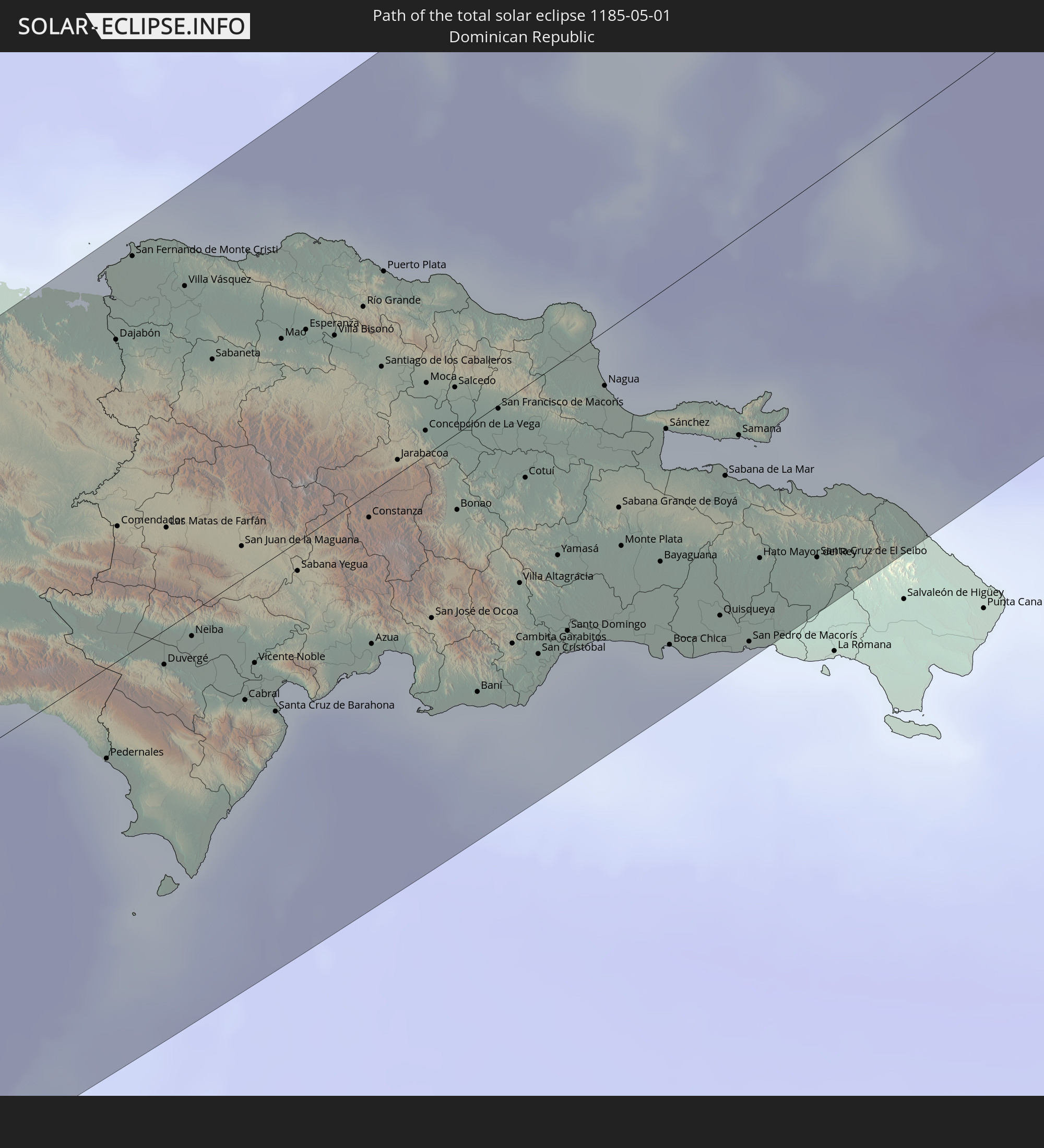
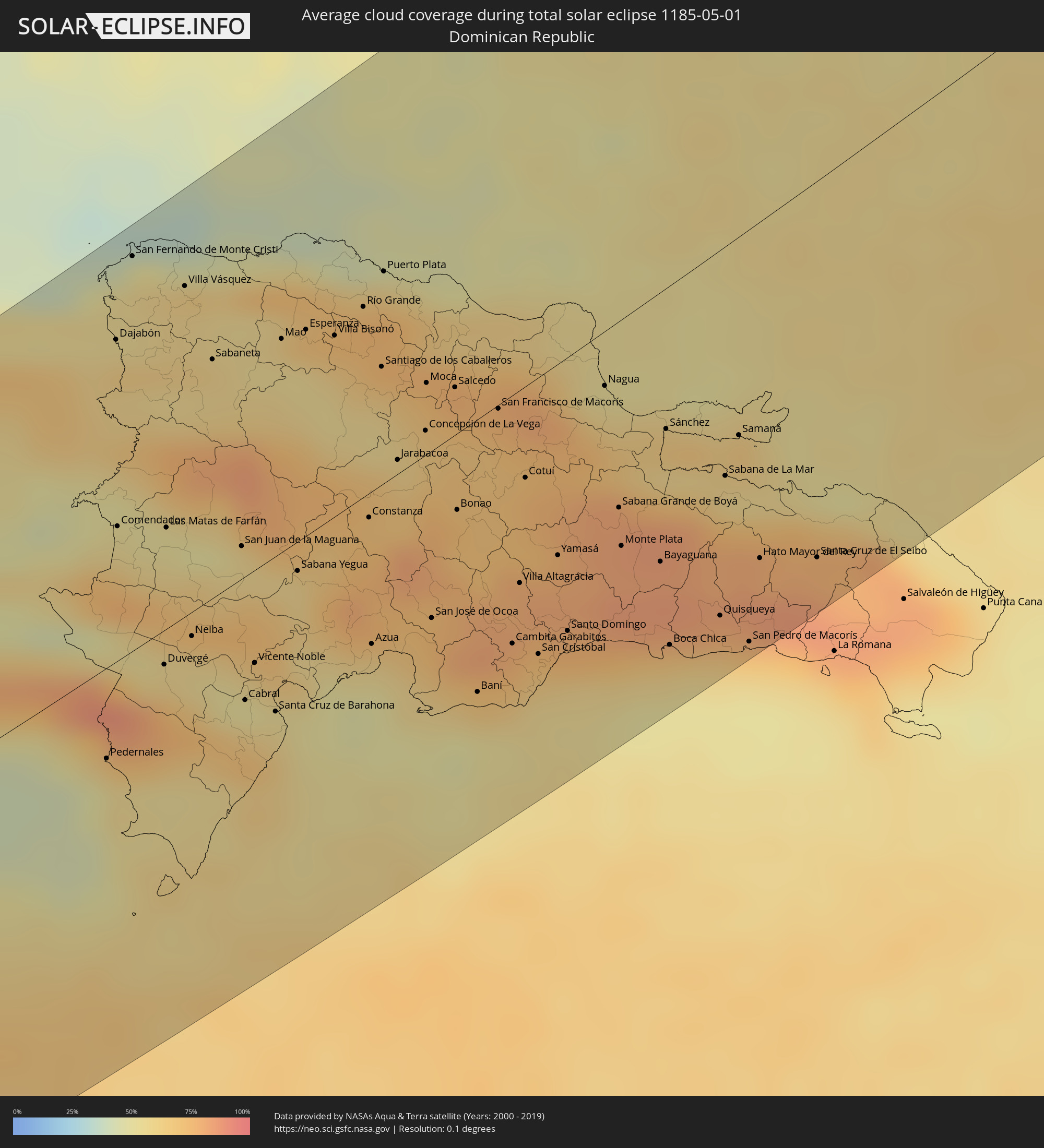 Dominikanische Republik
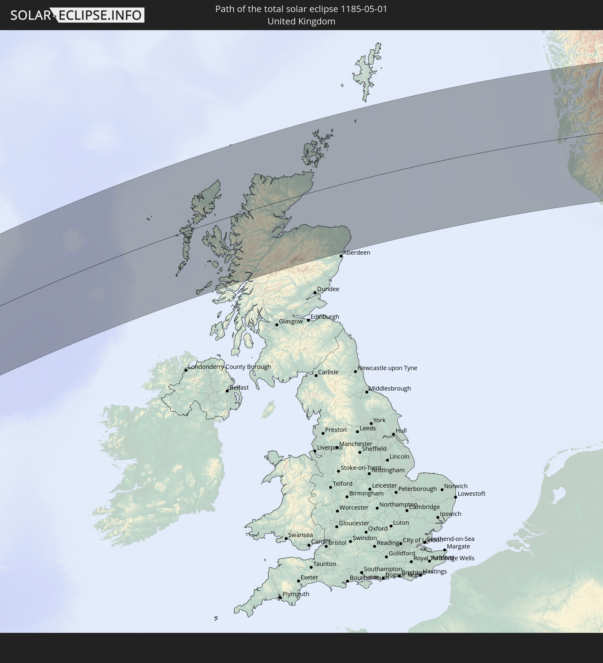
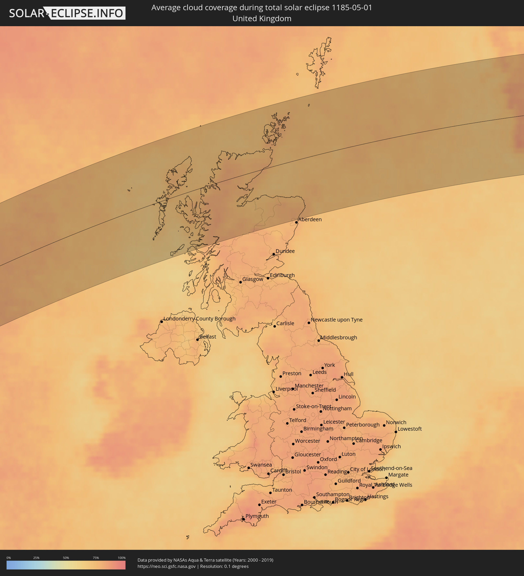 Vereinigtes Königreich
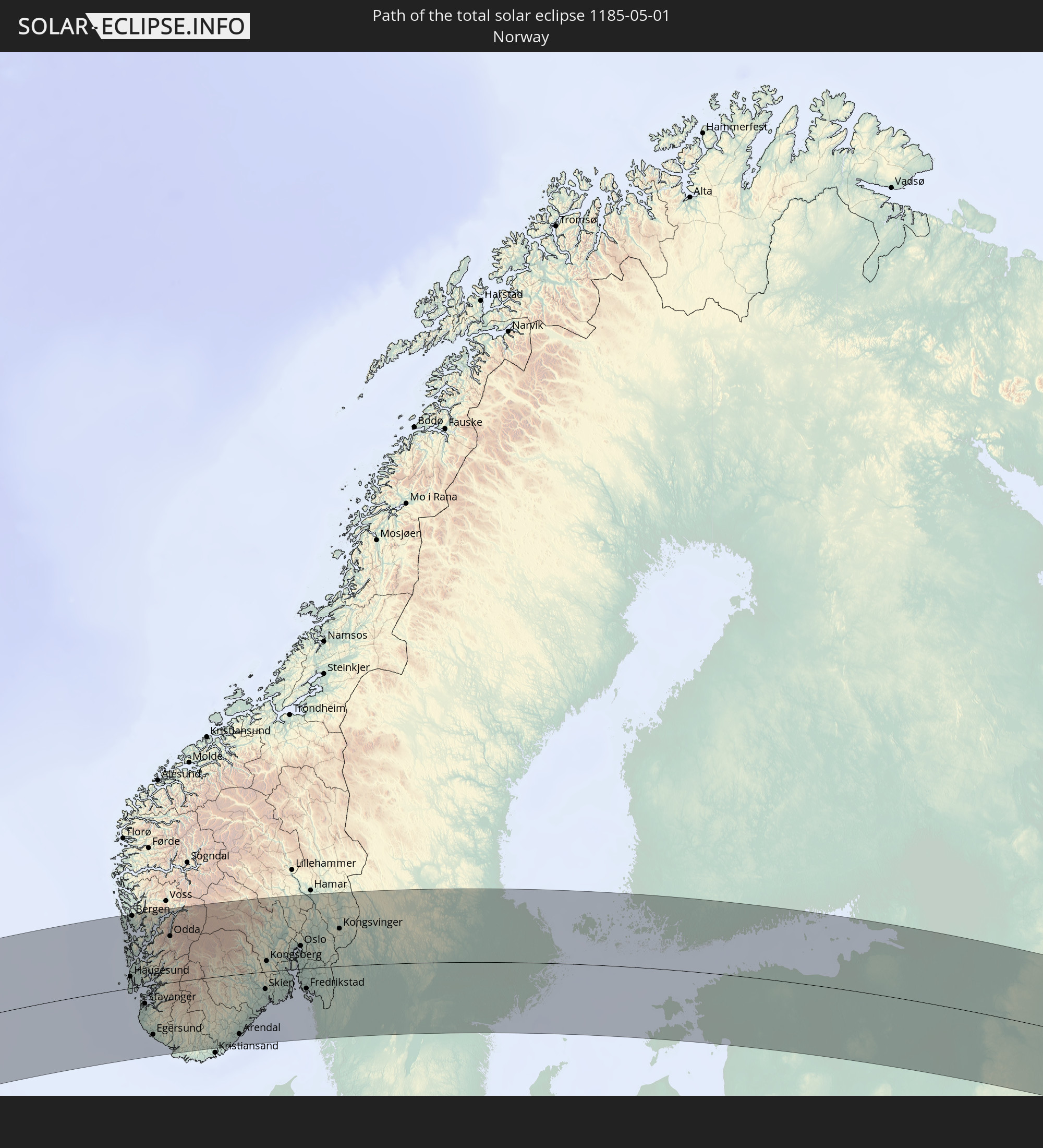
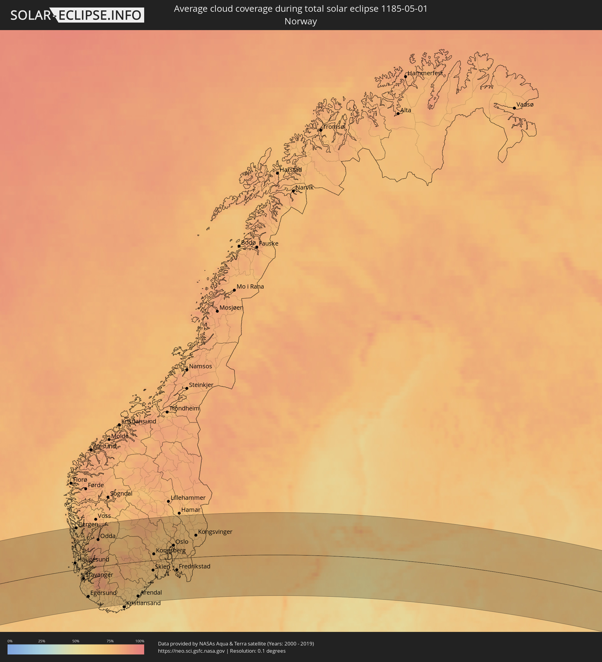 Norwegen
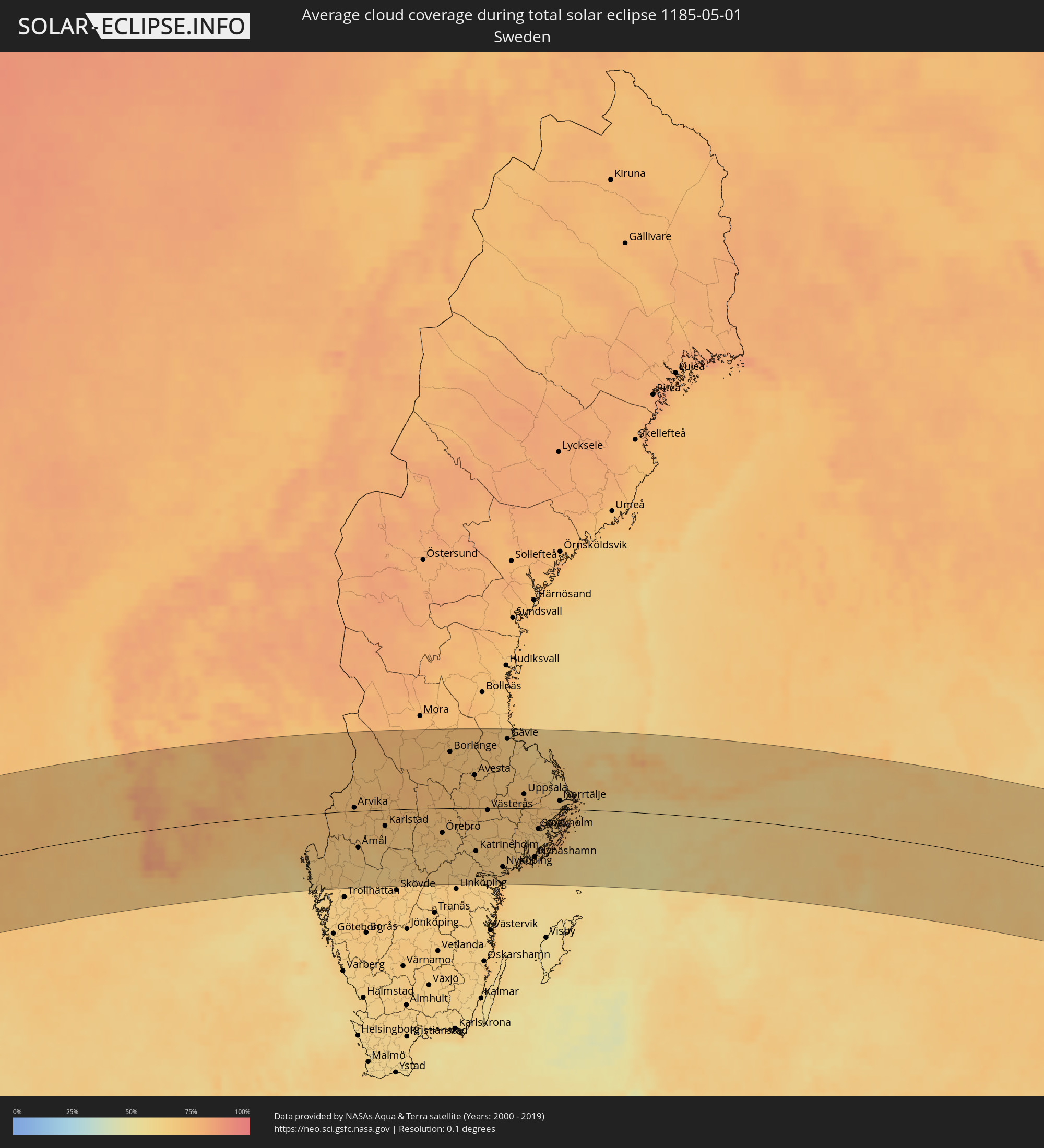 Schweden
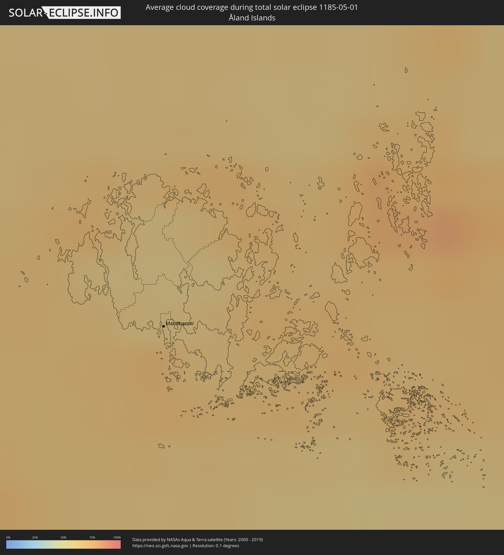 Åland Islands
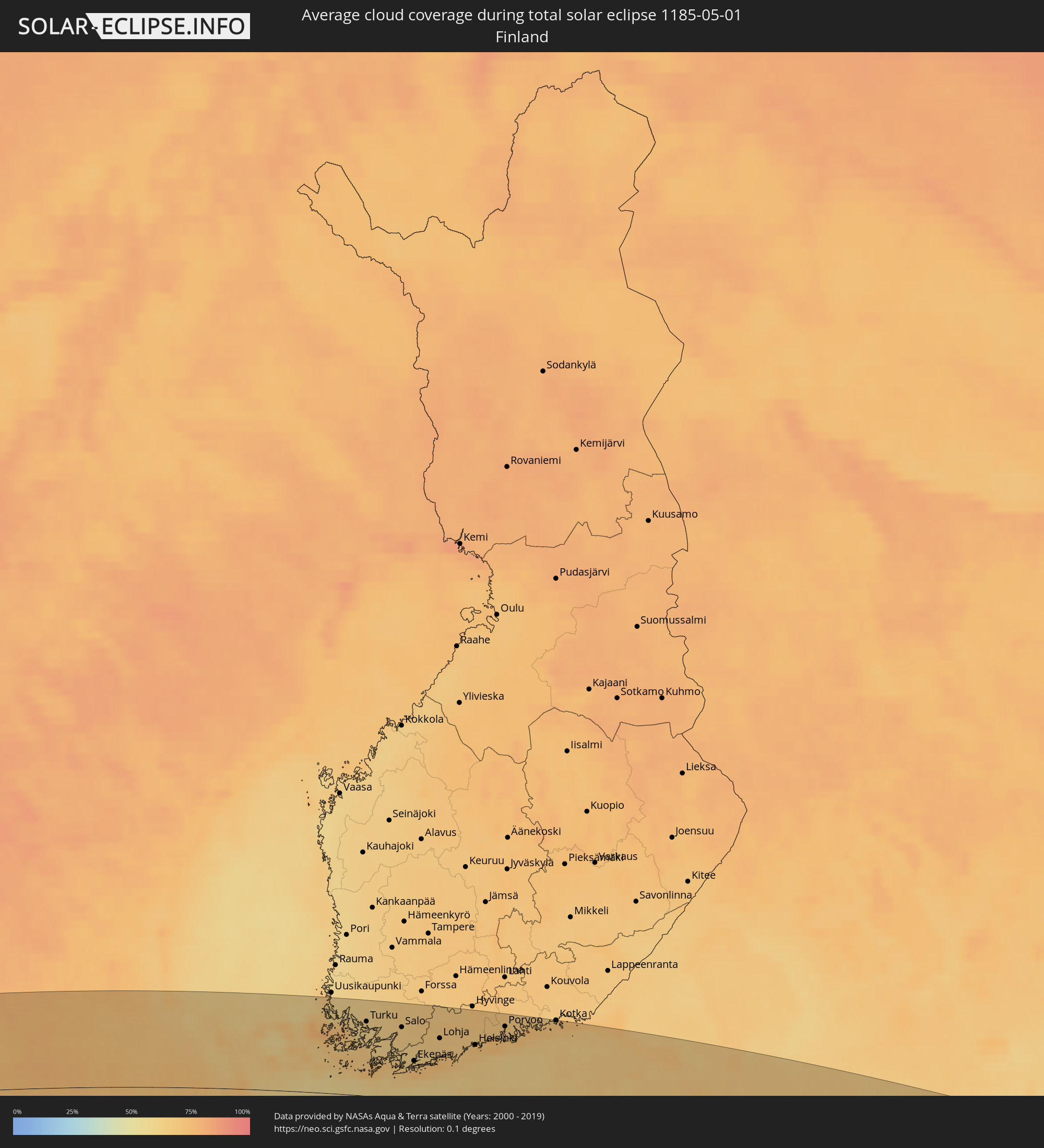 Finnland
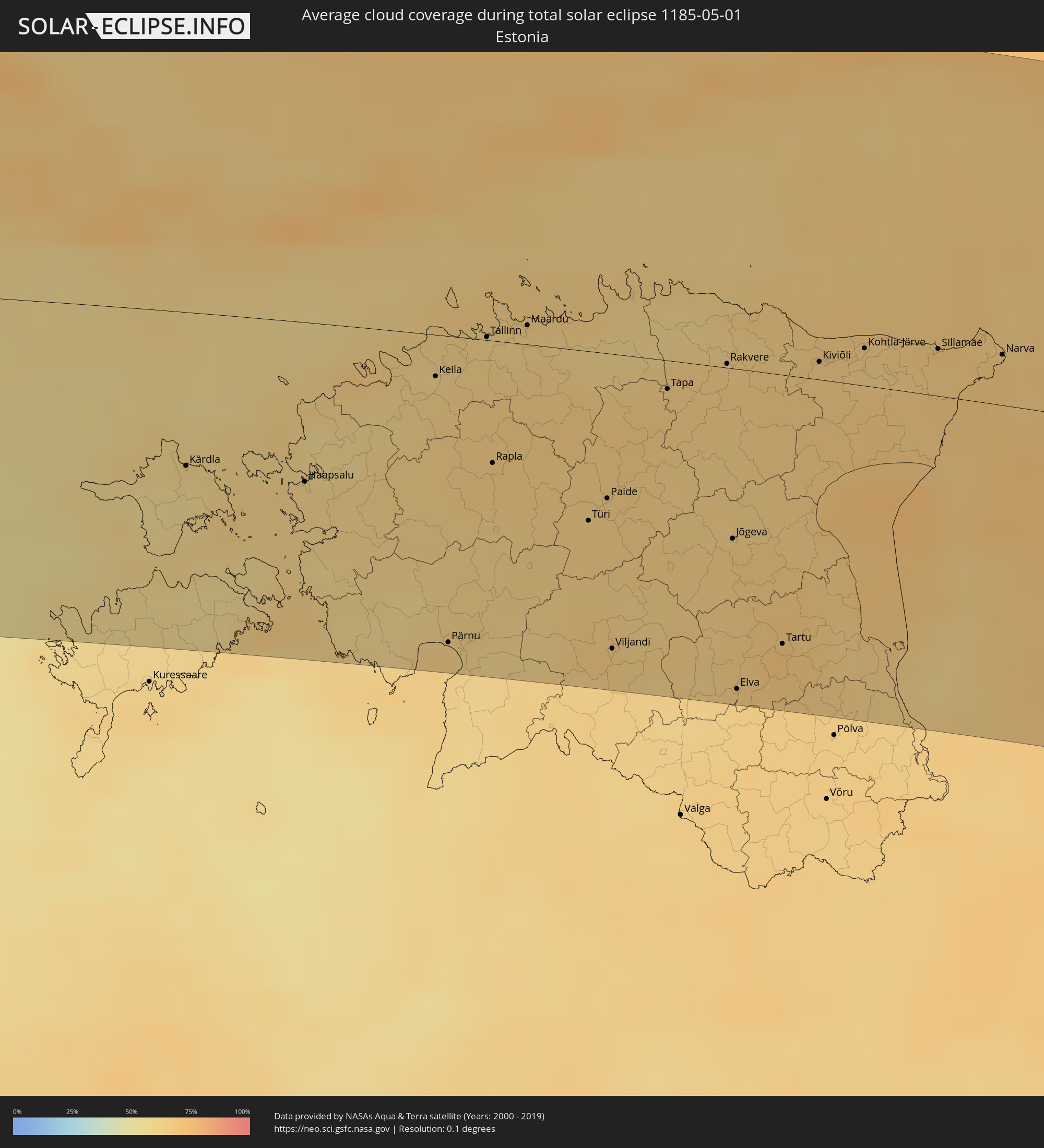 Estland
 Kasachstan
Orte im Finsternispfad
Die nachfolgene Tabelle zeigt Städte und Orte mit mehr als 5.000 Einwohnern, die sich im Finsternispfad befinden. Städte mit mehr als 100.000 Einwohnern sind dick gekennzeichnet. Mit einem Klick auf den Ort öffnet sich eine Detailkarte die die Lage des jeweiligen Ortes zusammen mit dem Verlauf der zentralen Finsternis präsentiert.
| Ort | Typ | Dauer der Verfinsterung | Ortszeit bei maximaler Verfinsterung | Entfernung zur Zentrallinie | Ø Bewölkung |
|
Nagarote, León
|
total | - | 06:07:20 UTC-05:45 | 122 km | 65% |
|
San Rafael del Sur, Managua
|
total | - | 06:06:51 UTC-05:45 | 74 km | 74% |
|
El Crucero, Managua
|
total | - | 06:06:59 UTC-05:45 | 84 km | 75% |
|
Managua, Managua
|
total | - | 06:07:08 UTC-05:45 | 96 km | 80% |
|
Diriamba, Carazo
|
total | - | 06:06:49 UTC-05:45 | 67 km | 77% |
|
Tipitapa, Managua
|
total | - | 06:07:11 UTC-05:45 | 97 km | 79% |
|
Masaya, Masaya
|
total | - | 06:06:56 UTC-05:45 | 73 km | 75% |
|
Nandaime, Granada
|
total | - | 06:06:41 UTC-05:45 | 49 km | 80% |
|
Granada, Granada
|
total | - | 06:06:51 UTC-05:45 | 63 km | 73% |
|
Rivas, Rivas
|
total | - | 06:06:18 UTC-05:45 | 7 km | 75% |
|
Boaco, Boaco
|
total | - | 06:07:25 UTC-05:45 | 107 km | 84% |
|
Santa Cruz, Guanacaste
|
total | - | 06:13:59 UTC-05:36 | 124 km | 75% |
|
Camoapa, Boaco
|
total | - | 06:07:18 UTC-05:45 | 92 km | 86% |
|
Liberia, Guanacaste
|
total | - | 06:14:21 UTC-05:36 | 92 km | 76% |
|
Juigalpa, Chontales
|
total | - | 06:06:58 UTC-05:45 | 58 km | 89% |
|
San José, Alajuela
|
total | - | 06:14:39 UTC-05:36 | 71 km | 90% |
|
Nueva Guinea, Atlántico Sur
|
total | - | 06:06:23 UTC-05:45 | 23 km | 92% |
|
Rama, Atlántico Sur
|
total | - | 06:06:53 UTC-05:45 | 16 km | 88% |
|
Bluefields, Atlántico Sur
|
total | - | 06:06:40 UTC-05:45 | 19 km | 78% |
|
San Andrés, Archipiélago de San Andrés, Providencia y Santa Catalina
|
total | - | 06:56:04 UTC-04:56 | 51 km | 75% |
|
Les Cayes, Sud
|
total | - | 07:11:08 UTC-04:49 | 98 km | 65% |
|
Miragoâne, Nippes
|
total | - | 07:11:37 UTC-04:49 | 84 km | 75% |
|
Tigwav, Ouest
|
total | - | 07:11:39 UTC-04:49 | 70 km | 79% |
|
Saint-Marc, Artibonite
|
total | - | 07:12:40 UTC-04:49 | 124 km | 69% |
|
Léogâne, Ouest
|
total | - | 07:11:49 UTC-04:49 | 64 km | 71% |
|
Jacmel, Sud-Est
|
total | - | 07:11:27 UTC-04:49 | 33 km | 51% |
|
Dessalines, Artibonite
|
total | - | 07:12:56 UTC-04:49 | 128 km | 59% |
|
Verrettes, Artibonite
|
total | - | 07:12:39 UTC-04:49 | 105 km | 60% |
|
Désarmes, Artibonite
|
total | - | 07:12:35 UTC-04:49 | 95 km | 58% |
|
Port-au-Prince, Ouest
|
total | - | 07:11:56 UTC-04:49 | 50 km | 78% |
|
Saint-Raphaël, Nord
|
total | - | 07:13:17 UTC-04:49 | 126 km | 57% |
|
Thomazeau, Ouest
|
total | - | 07:12:09 UTC-04:49 | 47 km | 49% |
|
Trou du Nord, Nord-Est
|
total | - | 07:13:35 UTC-04:49 | 132 km | 67% |
|
Hinche, Centre
|
total | - | 07:12:54 UTC-04:49 | 89 km | 51% |
|
Fond Parisien, Ouest
|
total | - | 07:11:58 UTC-04:49 | 26 km | 63% |
|
Fort Liberté, Nord-Est
|
total | - | 07:13:42 UTC-04:49 | 126 km | 55% |
|
San Juan de la Maguana, San Juan
|
total | - | 07:21:36 UTC-04:40 | 11 km | 59% |
|
Santa Cruz de Barahona, Barahona
|
total | - | 07:20:46 UTC-04:40 | 52 km | 59% |
|
Mao, Valverde
|
total | - | 07:22:45 UTC-04:40 | 71 km | 55% |
|
Azua, Azua
|
total | - | 07:21:13 UTC-04:40 | 51 km | 62% |
|
Santiago de los Caballeros, Santiago
|
total | - | 07:22:42 UTC-04:40 | 39 km | 63% |
|
Puerto Plata, Puerto Plata
|
total | - | 07:23:13 UTC-04:40 | 70 km | 63% |
|
Concepción de La Vega, La Vega
|
total | - | 07:22:25 UTC-04:40 | 8 km | 67% |
|
Moca, Espaillat
|
total | - | 07:22:40 UTC-04:40 | 24 km | 70% |
|
Bonao, Monseñor Nouel
|
total | - | 07:22:02 UTC-04:40 | 25 km | 71% |
|
Baní, Peravia
|
total | - | 07:21:05 UTC-04:40 | 91 km | 65% |
|
San Francisco de Macorís, Duarte
|
total | - | 07:22:37 UTC-04:40 | 1 km | 69% |
|
Villa Altagracia, San Cristóbal
|
total | - | 07:21:43 UTC-04:40 | 64 km | 78% |
|
Cotuí, Sánchez Ramírez
|
total | - | 07:22:17 UTC-04:40 | 30 km | 75% |
|
Santo Domingo, Nacional
|
total | - | 07:21:30 UTC-04:40 | 90 km | 75% |
|
Boca Chica, Santo Domingo
|
total | - | 07:21:33 UTC-04:40 | 118 km | 68% |
|
San Pedro de Macorís, San Pedro de Macorís
|
total | - | 07:21:40 UTC-04:40 | 135 km | 68% |
|
Isle of Lewis, Scotland
|
total | - | 14:06:16 UTC+00:00 | 48 km | 72% |
|
Isle of Skye, Scotland
|
total | - | 14:06:27 UTC+00:00 | 45 km | 76% |
|
Fort William, Scotland
|
total | - | 14:07:42 UTC+00:00 | 124 km | 79% |
|
Inverness, Scotland
|
total | - | 14:08:35 UTC+00:00 | 69 km | 74% |
|
Nairn, Scotland
|
total | - | 14:08:55 UTC+00:00 | 64 km | 71% |
|
Forres, Scotland
|
total | - | 14:09:11 UTC+00:00 | 65 km | 73% |
|
Thurso, Scotland
|
total | - | 14:09:07 UTC+00:00 | 39 km | 74% |
|
Elgin, Scotland
|
total | - | 14:09:29 UTC+00:00 | 65 km | 74% |
|
Wick, Scotland
|
total | - | 14:09:34 UTC+00:00 | 16 km | 77% |
|
Buckie, Scotland
|
total | - | 14:09:51 UTC+00:00 | 68 km | 73% |
|
Orkney, Scotland
|
total | - | 14:09:35 UTC+00:00 | 72 km | 76% |
|
Kirkwall, Scotland
|
total | - | 14:09:35 UTC+00:00 | 72 km | 76% |
|
Inverurie, Scotland
|
total | - | 14:10:31 UTC+00:00 | 120 km | 78% |
|
Ellon, Scotland
|
total | - | 14:10:49 UTC+00:00 | 116 km | 79% |
|
Fraserburgh, Scotland
|
total | - | 14:10:48 UTC+00:00 | 82 km | 73% |
|
Peterhead, Scotland
|
total | - | 14:11:04 UTC+00:00 | 104 km | 77% |
|
Haugesund, Rogaland
|
total | - | 15:16:58 UTC+01:00 | 21 km | 66% |
|
Bergen, Hordaland
|
total | - | 15:16:29 UTC+01:00 | 128 km | 66% |
|
Stavanger, Rogaland
|
total | - | 15:17:36 UTC+01:00 | 32 km | 70% |
|
Arendal, Aust-Agder
|
total | - | 15:20:28 UTC+01:00 | 110 km | 64% |
|
Skien, Telemark
|
total | - | 15:20:41 UTC+01:00 | 31 km | 69% |
|
Kongsberg, Buskerud
|
total | - | 15:20:24 UTC+01:00 | 19 km | 72% |
|
Drammen, Buskerud
|
total | - | 15:20:47 UTC+01:00 | 25 km | 72% |
|
Sandefjord, Vestfold
|
total | - | 15:21:13 UTC+01:00 | 43 km | 69% |
|
Hønefoss, Buskerud
|
total | - | 15:20:32 UTC+01:00 | 72 km | 70% |
|
Tønsberg, Vestfold
|
total | - | 15:21:16 UTC+01:00 | 29 km | 70% |
|
Moss, Østfold
|
total | - | 15:21:21 UTC+01:00 | 12 km | 72% |
|
Oslo, Oslo
|
total | - | 15:21:05 UTC+01:00 | 41 km | 74% |
|
Ski, Akershus
|
total | - | 15:21:17 UTC+01:00 | 19 km | 72% |
|
Fredrikstad, Østfold
|
total | - | 15:21:43 UTC+01:00 | 37 km | 72% |
|
Lillestrøm, Akershus
|
total | - | 15:21:17 UTC+01:00 | 45 km | 73% |
|
Halden, Østfold
|
total | - | 15:22:08 UTC+01:00 | 49 km | 69% |
|
Karlstad, Värmland
|
total | - | 15:23:32 UTC+01:00 | 27 km | 69% |
|
Karlskoga, Örebro
|
total | - | 15:24:19 UTC+01:00 | 35 km | 70% |
|
Motala, Östergötland
|
total | - | 15:25:19 UTC+01:00 | 123 km | 66% |
|
Örebro, Örebro
|
total | - | 15:24:50 UTC+01:00 | 41 km | 72% |
|
Borlänge, Dalarna
|
total | - | 15:23:59 UTC+01:00 | 93 km | 73% |
|
Falun, Dalarna
|
total | - | 15:24:01 UTC+01:00 | 106 km | 72% |
|
Norrköping, Östergötland
|
total | - | 15:26:06 UTC+01:00 | 118 km | 67% |
|
Eskilstuna, Södermanland
|
total | - | 15:25:40 UTC+01:00 | 32 km | 69% |
|
Västerås, Västmanland
|
total | - | 15:25:29 UTC+01:00 | 4 km | 71% |
|
Nyköping, Södermanland
|
total | - | 15:26:32 UTC+01:00 | 100 km | 67% |
|
Gävle, Gävleborg
|
total | - | 15:24:56 UTC+01:00 | 114 km | 68% |
|
Södertälje, Stockholm
|
total | - | 15:26:34 UTC+01:00 | 50 km | 68% |
|
Uppsala, Uppsala
|
total | - | 15:25:59 UTC+01:00 | 24 km | 71% |
|
Upplands Väsby, Stockholm
|
total | - | 15:26:28 UTC+01:00 | 14 km | 70% |
|
Stockholm, Stockholm
|
total | - | 15:26:44 UTC+01:00 | 34 km | 66% |
|
Haninge, Stockholm
|
total | - | 15:26:56 UTC+01:00 | 53 km | 66% |
|
Mariehamn, Mariehamns stad
|
total | - | 16:07:01 UTC+01:39 | 54 km | 71% |
|
Turku, Southwest Finland
|
total | - | 16:08:01 UTC+01:39 | 101 km | 61% |
|
Länsi-Turunmaa, Southwest Finland
|
total | - | 16:08:11 UTC+01:39 | 84 km | 61% |
|
Pargas, Southwest Finland
|
total | - | 16:08:11 UTC+01:39 | 85 km | 61% |
|
Paimio, Southwest Finland
|
total | - | 16:08:15 UTC+01:39 | 104 km | 64% |
|
Salo, Southwest Finland
|
total | - | 16:08:34 UTC+01:39 | 97 km | 65% |
|
Ekenäs, Uusimaa
|
total | - | 16:09:08 UTC+01:39 | 53 km | 67% |
|
Haapsalu, Lääne
|
total | - | 16:09:25 UTC+01:39 | 60 km | 62% |
|
Lohja, Uusimaa
|
total | - | 16:09:12 UTC+01:39 | 87 km | 66% |
|
Vihti, Uusimaa
|
total | - | 16:09:09 UTC+01:39 | 107 km | 68% |
|
Keila, Harjumaa
|
total | - | 16:09:32 UTC+01:39 | 16 km | 63% |
|
Pärnu, Pärnumaa
|
total | - | 16:10:31 UTC+01:39 | 117 km | 64% |
|
Espoo, Uusimaa
|
total | - | 16:09:33 UTC+01:39 | 86 km | 69% |
|
Tallinn, Harjumaa
|
total | - | 16:09:35 UTC+01:39 | 1 km | 64% |
|
Nurmijärvi, Uusimaa
|
total | - | 16:09:21 UTC+01:39 | 115 km | 69% |
|
Helsinki, Uusimaa
|
total | - | 16:09:44 UTC+01:39 | 83 km | 70% |
|
Maardu, Harjumaa
|
total | - | 16:09:41 UTC+01:39 | 7 km | 62% |
|
Vantaa, Uusimaa
|
total | - | 16:09:39 UTC+01:39 | 98 km | 66% |
|
Järvenpää, Uusimaa
|
total | - | 16:09:29 UTC+01:39 | 118 km | 68% |
|
Paide, Järvamaa
|
total | - | 16:10:34 UTC+01:39 | 55 km | 65% |
|
Viljandi, Viljandimaa
|
total | - | 16:11:08 UTC+01:39 | 112 km | 65% |
|
Porvoo, Uusimaa
|
total | - | 16:09:52 UTC+01:39 | 112 km | 66% |
|
Tapa, Lääne-Virumaa
|
total | - | 16:10:23 UTC+01:39 | 11 km | 66% |
|
Lovisa, Uusimaa
|
total | - | 16:10:04 UTC+01:39 | 123 km | 68% |
|
Rakvere, Lääne-Virumaa
|
total | - | 16:10:30 UTC+01:39 | 2 km | 65% |
|
Jõgeva, Jõgevamaa
|
total | - | 16:11:09 UTC+01:39 | 64 km | 65% |
|
Tartu, Tartu
|
total | - | 16:11:42 UTC+01:39 | 102 km | 70% |
|
Kotka, Kymenlaakso
|
total | - | 16:10:23 UTC+01:39 | 129 km | 71% |
|
Kiviõli, Ida-Virumaa
|
total | - | 16:10:47 UTC+01:39 | 7 km | 66% |
|
Kohtla-Järve, Ida-Virumaa
|
total | - | 16:10:53 UTC+01:39 | 14 km | 64% |
|
Jõhvi, Ida-Virumaa
|
total | - | 16:11:00 UTC+01:39 | 11 km | 63% |
|
Sillamäe, Ida-Virumaa
|
total | - | 16:11:07 UTC+01:39 | 18 km | 65% |
|
Narva, Ida-Virumaa
|
total | - | 16:11:21 UTC+01:39 | 19 km | 68% |
|
Saint Petersburg, St.-Petersburg
|
total | - | 17:02:57 UTC+02:30 | 100 km | 65% |
|
Cherepovets, Vologda
|
total | - | 17:06:32 UTC+02:30 | 103 km | 66% |
|
Rybinsk, Jaroslavl
|
total | - | 17:08:04 UTC+02:30 | 0 km | 64% |
|
Yaroslavl, Jaroslavl
|
total | - | 17:08:50 UTC+02:30 | 28 km | 65% |
|
Kostroma, Kostroma
|
total | - | 17:08:55 UTC+02:30 | 3 km | 67% |
|
Ivanovo, Ivanovo
|
total | - | 17:09:50 UTC+02:30 | 78 km | 64% |
|
Dzerzhinsk, Nizjnij Novgorod
|
total | - | 17:11:14 UTC+02:30 | 114 km | 63% |
|
Nizhniy Novgorod, Nizjnij Novgorod
|
total | - | 17:11:14 UTC+02:30 | 95 km | 62% |
|
Cheboksary, Chuvashia
|
total | - | 17:11:56 UTC+02:30 | 51 km | 62% |
|
Yoshkar-Ola, Mariy-El
|
total | - | 17:11:25 UTC+02:30 | 15 km | 65% |
|
Kazan, Tatarstan
|
total | - | 17:12:30 UTC+02:30 | 47 km | 65% |
|
Nizhnekamsk, Tatarstan
|
total | - | 17:12:50 UTC+02:30 | 2 km | 66% |
|
Naberezhnyye Chelny, Tatarstan
|
total | - | 17:12:44 UTC+02:30 | 21 km | 66% |
|
Sterlitamak, Bashkortostan
|
total | - | 18:47:16 UTC+04:02 | 107 km | 67% |
|
Ufa, Bashkortostan
|
total | - | 18:46:03 UTC+04:02 | 8 km | 69% |
|
Magnitogorsk, Chelyabinsk
|
total | - | 18:47:14 UTC+04:02 | 44 km | 71% |
|
Dzhetygara, Qostanay
|
total | - | 19:07:32 UTC+04:21 | 108 km | 64% |
|
Komsomolets, Qostanay
|
total | - | 19:05:48 UTC+04:21 | 74 km | 65% |
|
Lisakovsk, Qostanay
|
total | - | 19:06:58 UTC+04:21 | 34 km | 56% |
|
Tobol, Qostanay
|
total | - | 19:06:48 UTC+04:21 | 16 km | 60% |
|
Fedorovka, Qostanay
|
total | - | 19:05:49 UTC+04:21 | 81 km | 66% |
|
Kachar, Qostanay
|
total | - | 19:06:04 UTC+04:21 | 59 km | 61% |
|
Rudnyy, Qostanay
|
total | - | 19:06:25 UTC+04:21 | 27 km | 62% |
|
Kostanay, Qostanay
|
total | - | 19:06:05 UTC+04:21 | 66 km | 59% |
|
Qusmuryn, Qostanay
|
total | - | 19:06:39 UTC+04:21 | 20 km | 64% |
|
Derzhavīnsk, Aqmola
|
total | - | 19:07:35 UTC+04:21 | 62 km | 55% |
|
Esil, Aqmola
|
total | - | 19:06:44 UTC+04:21 | 26 km | 60% |
|
Zhaqsy, Aqmola
|
total | - | 19:06:33 UTC+04:21 | 50 km | 61% |
|
Atbasar, Aqmola
|
total | - | 19:06:22 UTC+04:21 | 73 km | 61% |
|
Astrakhan, Aqmola
|
total | - | 19:06:13 UTC+04:21 | 92 km | 59% |