Total solar eclipse of 05/01/1185
| Day of week: | Wednesday |
| Maximum duration of eclipse: | 05m10s |
| Maximum width of eclipse path: | 280 km |
| Saros cycle: | 115 |
| Coverage: | 100% |
| Magnitude: | 1.0736 |
| Gamma: | 0.5264 |
Wo kann man die Sonnenfinsternis vom 05/01/1185 sehen?
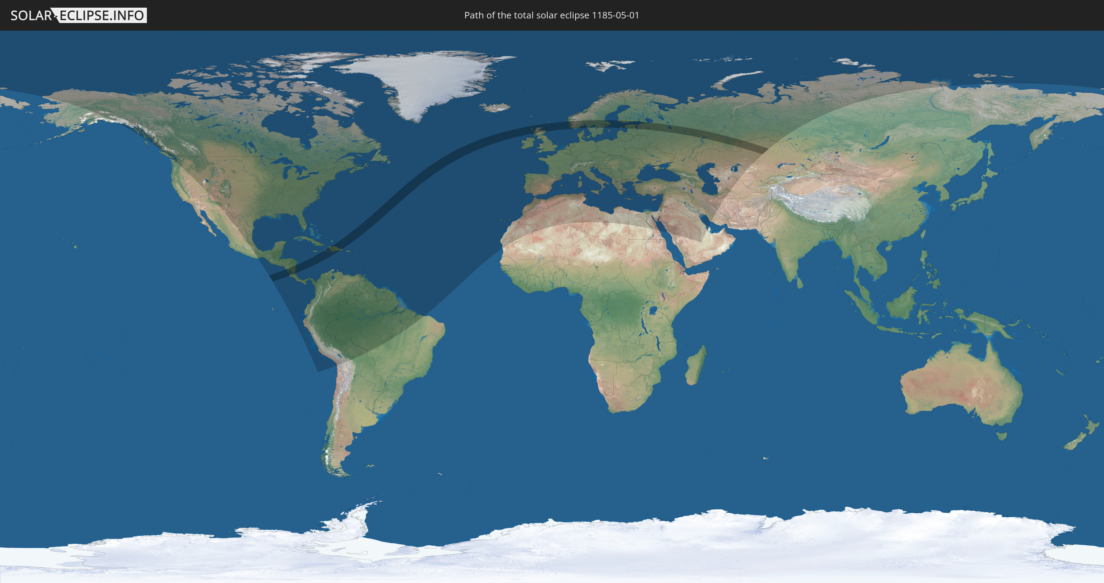
Die Sonnenfinsternis am 05/01/1185 kann man in 126 Ländern als partielle Sonnenfinsternis beobachten.
Der Finsternispfad verläuft durch 13 Länder. Nur in diesen Ländern ist sie als total Sonnenfinsternis zu sehen.
In den folgenden Ländern ist die Sonnenfinsternis total zu sehen
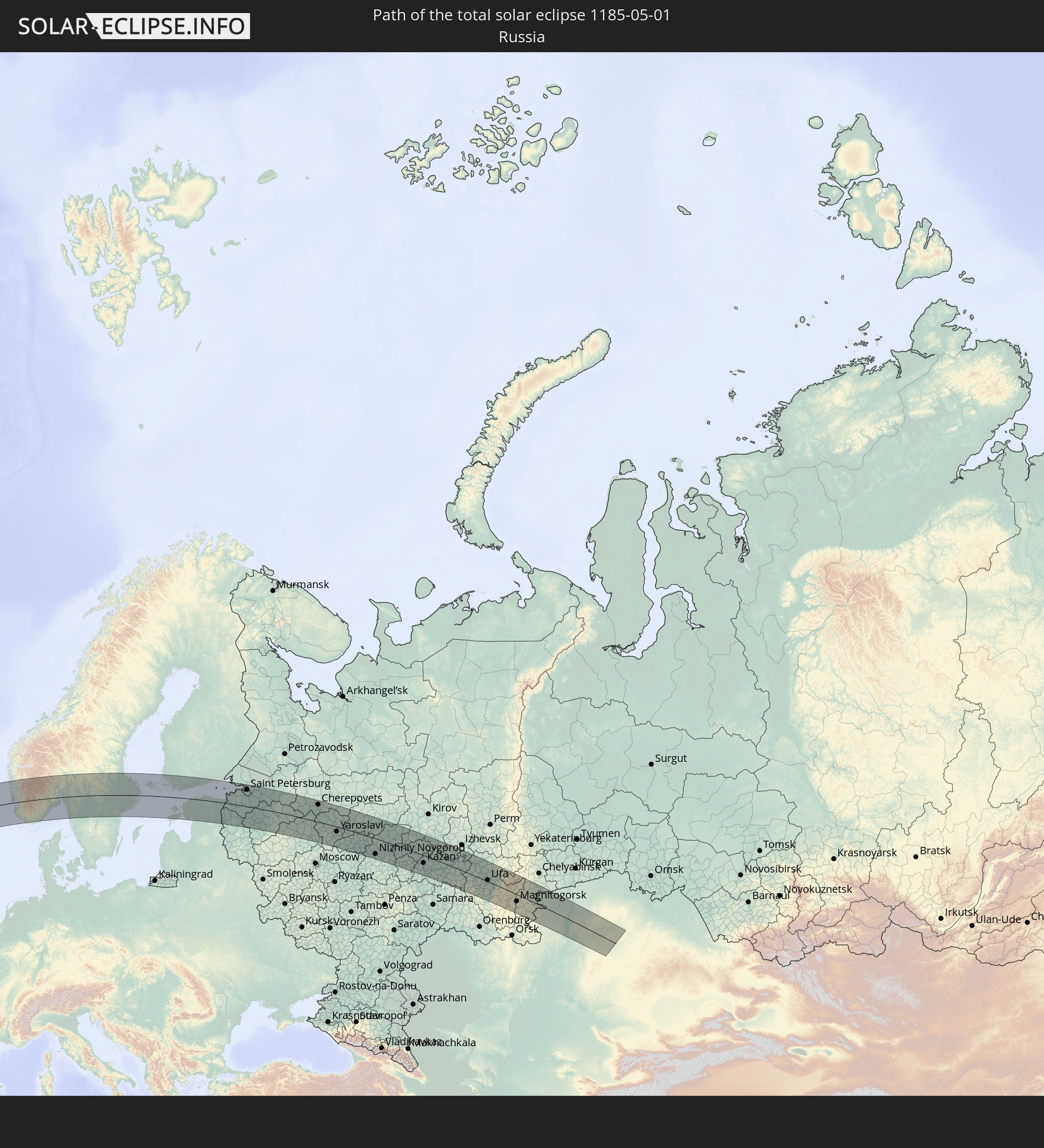 Russia
 Nicaragua
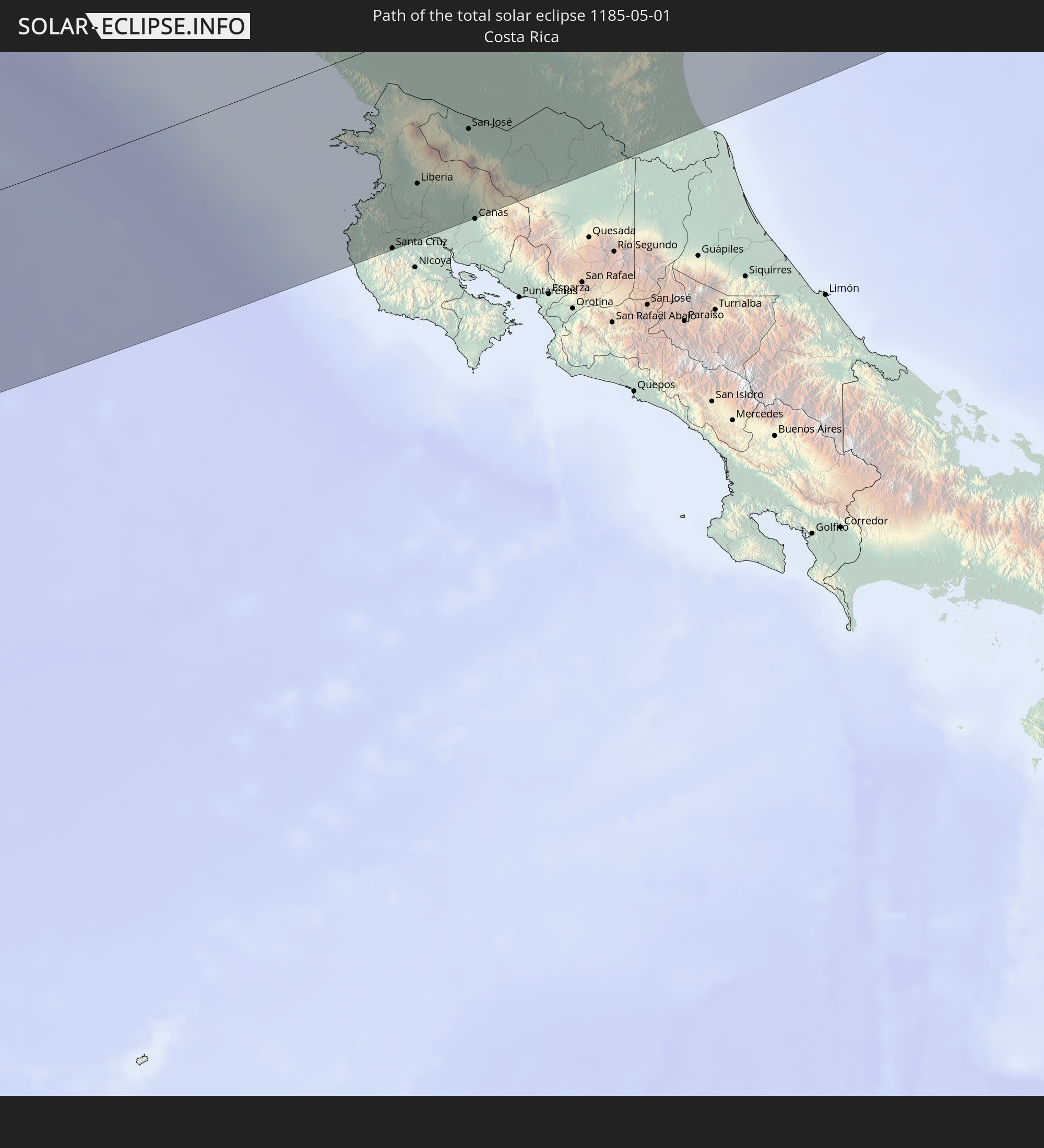 Costa Rica
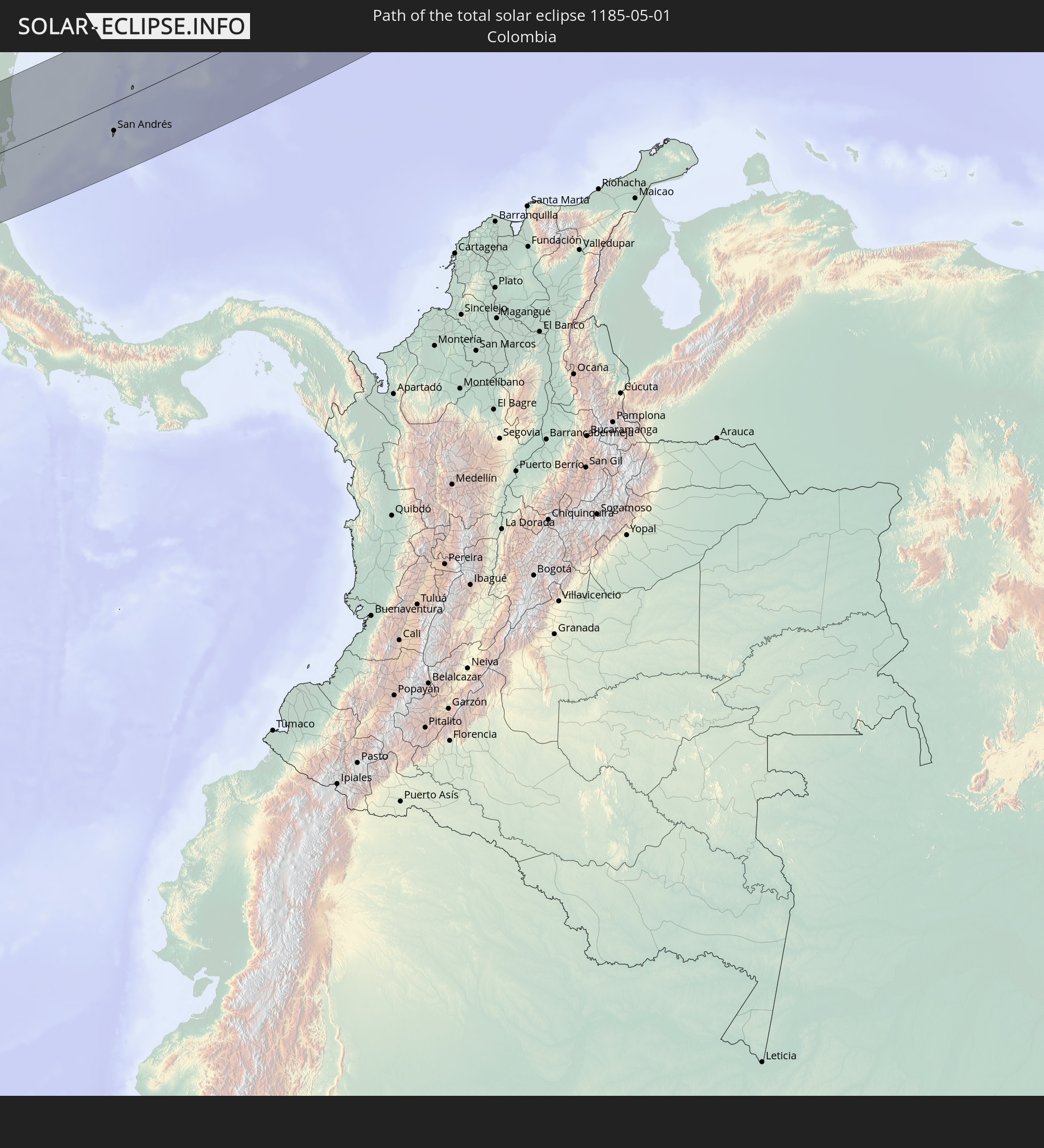 Colombia
 Haiti
Haiti
 Dominican Republic
 United Kingdom
 Norway
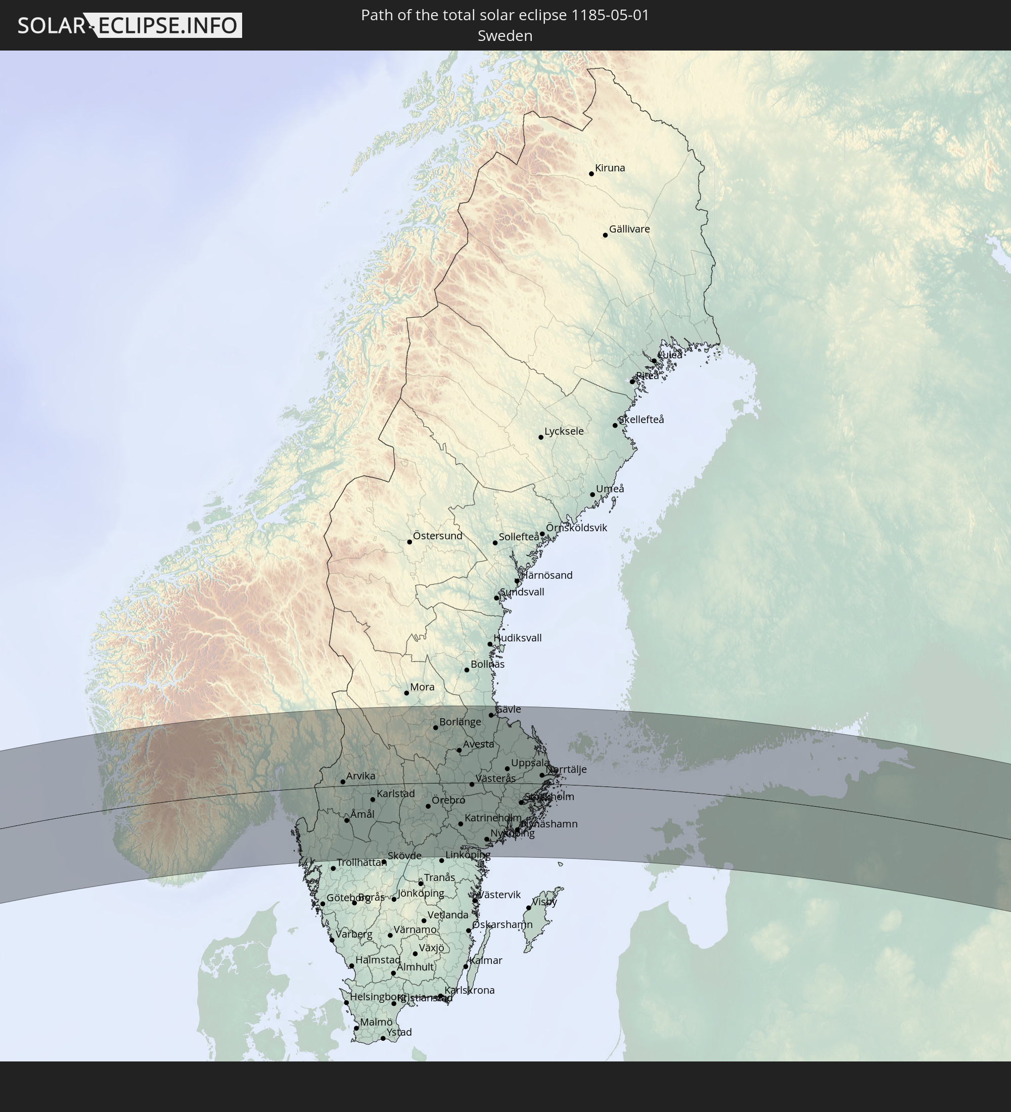 Sweden
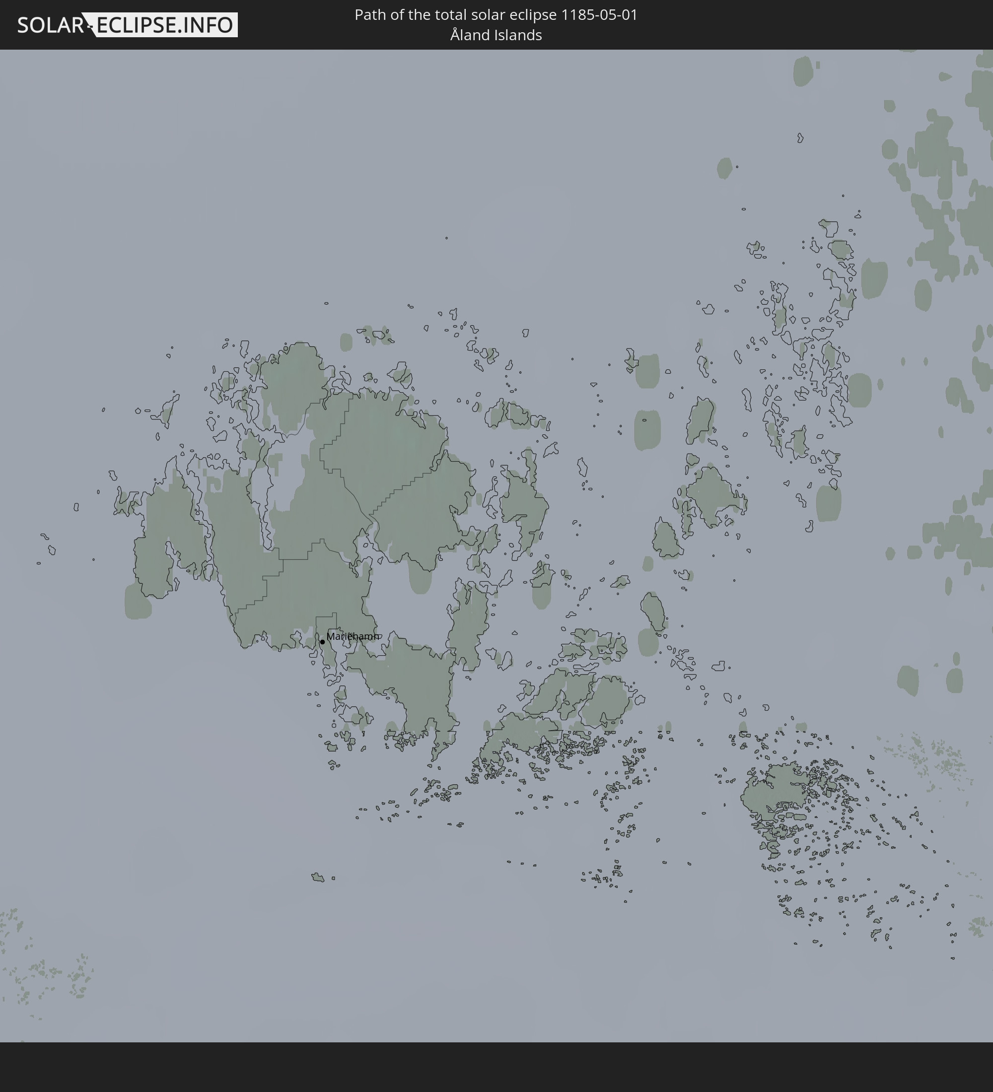 Åland Islands
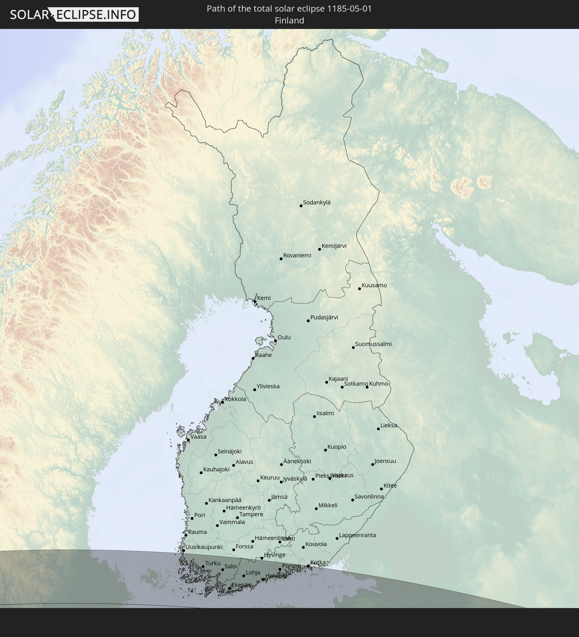 Finland
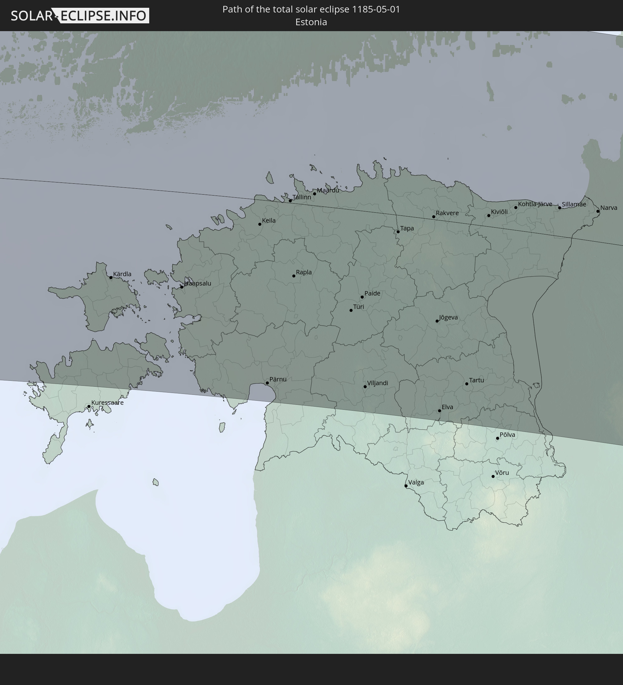 Estonia
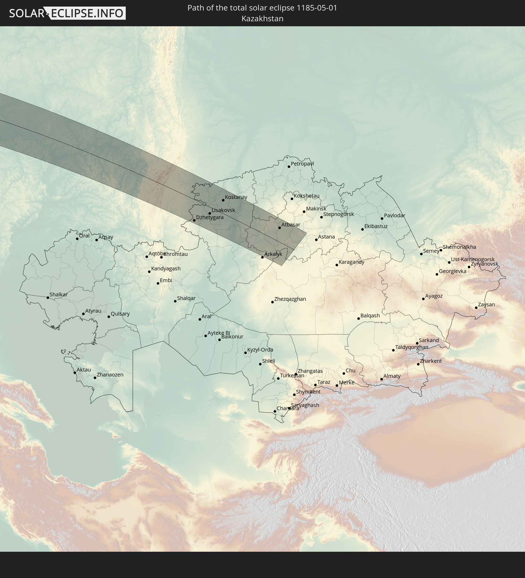 Kazakhstan
In den folgenden Ländern ist die Sonnenfinsternis partiell zu sehen
 Russia
 United States
 United States Minor Outlying Islands
 Canada
 Mexico
 Chile
Chile
 Greenland
 Guatemala
 Ecuador
 El Salvador
 Honduras
 Belize
 Nicaragua
 Costa Rica
 Cuba
Cuba
 Panama
 Colombia
 Cayman Islands
 Peru
Peru
 The Bahamas
 Jamaica
 Haiti
Haiti
 Brazil
 Venezuela
 Turks and Caicos Islands
 Dominican Republic
 Aruba
Aruba
 Bolivia
 Puerto Rico
 United States Virgin Islands
 Bermuda
 British Virgin Islands
 Anguilla
 Collectivity of Saint Martin
 Saint Barthélemy
 Saint Kitts and Nevis
 Antigua and Barbuda
 Montserrat
 Trinidad and Tobago
 Guadeloupe
 Grenada
 Dominica
 Saint Vincent and the Grenadines
 Guyana
 Martinique
 Saint Lucia
 Barbados
 Suriname
 Saint Pierre and Miquelon
 French Guiana
 Portugal
 Cabo Verde
 Iceland
 Spain
Spain
 Mauritania
 Morocco
 Mali
Mali
 Republic of Ireland
 Svalbard and Jan Mayen
 Algeria
 United Kingdom
 Faroe Islands
 Gibraltar
 France
 Isle of Man
 Guernsey
 Jersey
 Andorra
 Belgium
 Netherlands
 Norway
 Luxembourg
 Germany
 Switzerland
 Italy
Italy
 Monaco
 Tunisia
 Denmark
 Libya
Libya
 Liechtenstein
 Austria
 Sweden
 Czechia
 San Marino
 Vatican City
 Slovenia
 Croatia
 Poland
 Malta
Malta
 Bosnia and Herzegovina
 Hungary
 Slovakia
 Montenegro
 Serbia
 Albania
 Åland Islands
 Greece
 Romania
 Republic of Macedonia
 Finland
 Lithuania
 Latvia
 Estonia
 Ukraine
 Bulgaria
 Belarus
 Egypt
Egypt
 Turkey
 Moldova
 Cyprus
 State of Palestine
 Israel
 Saudi Arabia
 Jordan
 Lebanon
 Syria
Syria
 Iraq
Iraq
 Georgia
 Armenia
 Iran
Iran
 Azerbaijan
 Kazakhstan
 Kuwait
 Bahrain
 Turkmenistan
 Uzbekistan
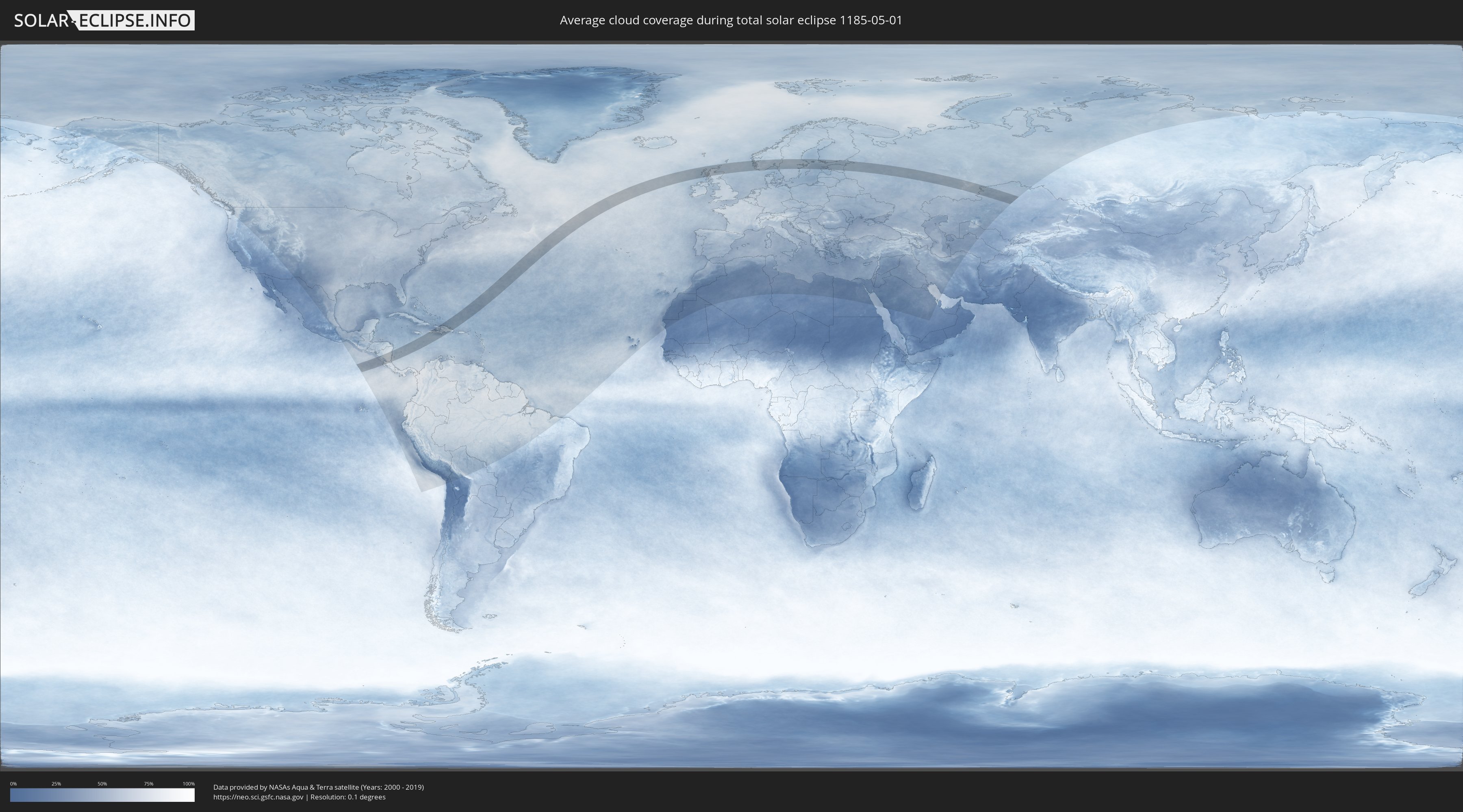
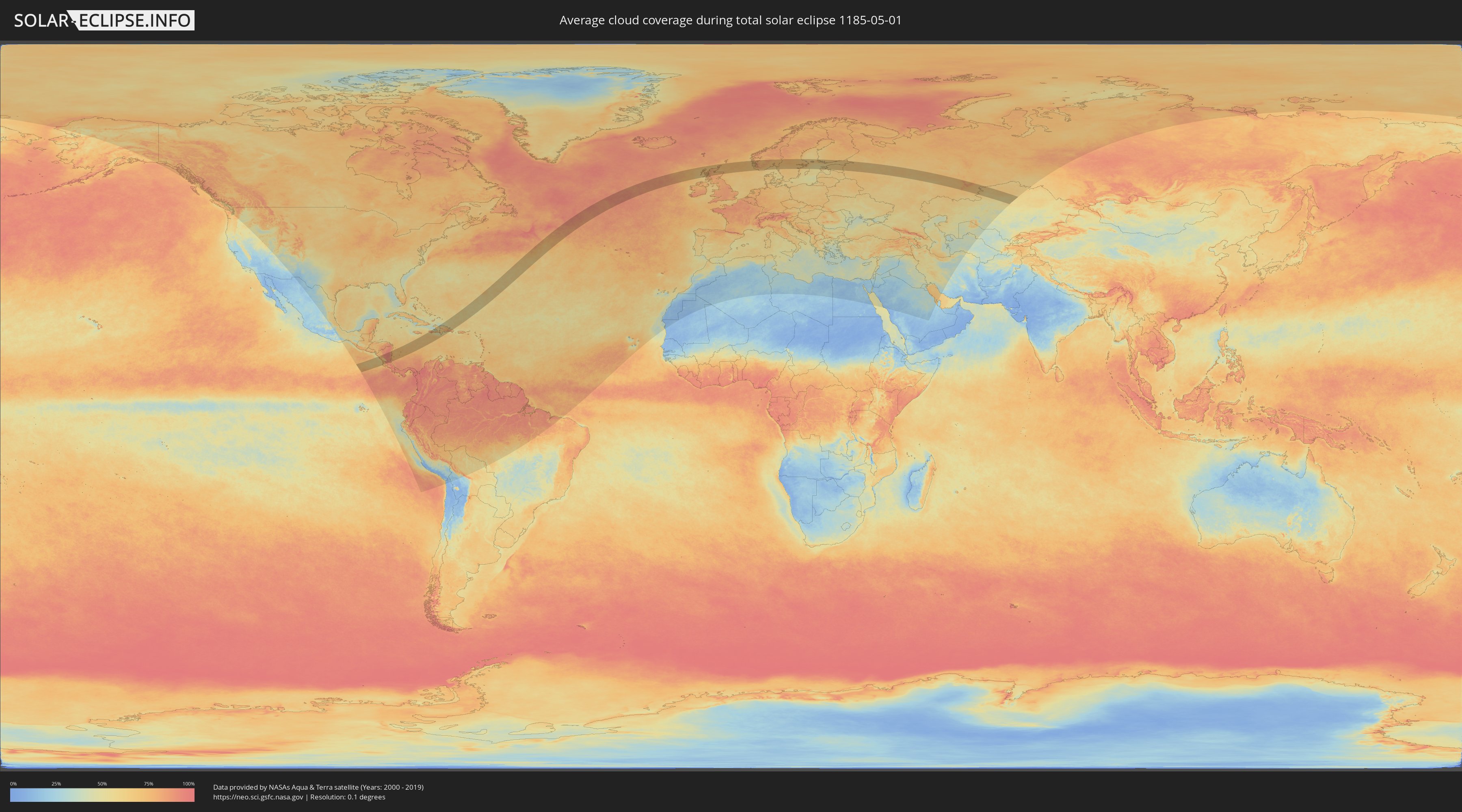
How will be the weather during the total solar eclipse on 05/01/1185?
Where is the best place to see the total solar eclipse of 05/01/1185?
The following maps show the average cloud coverage for the day of the total solar eclipse.
With the help of these maps, it is possible to find the place along the eclipse path, which has the best
chance of a cloudless sky.
Nevertheless, you should consider local circumstances and inform about the weather of your chosen
observation site.
The data is provided by NASAs satellites
AQUA and TERRA.
The cloud maps are averaged over a period of 19 years (2000 - 2019).
Detailed country maps
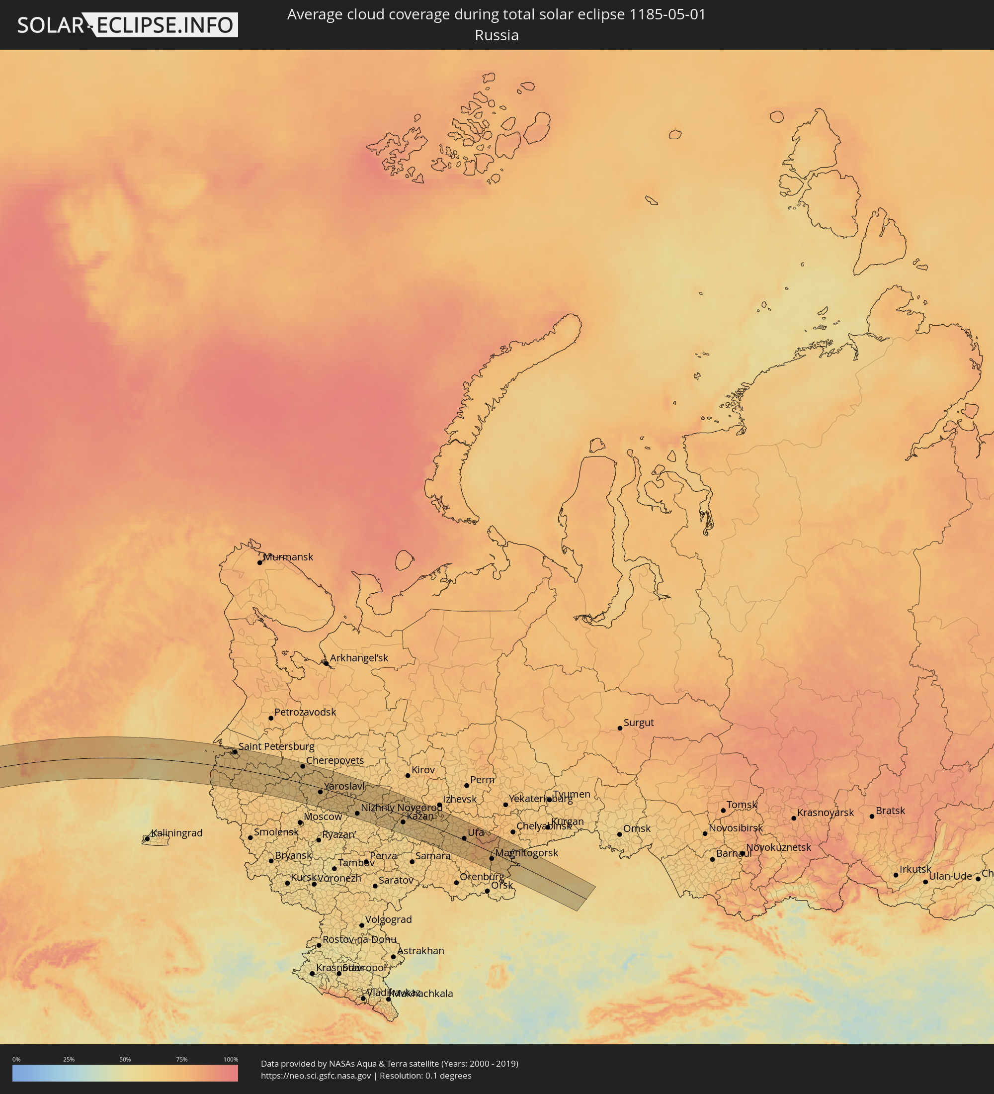 Russia
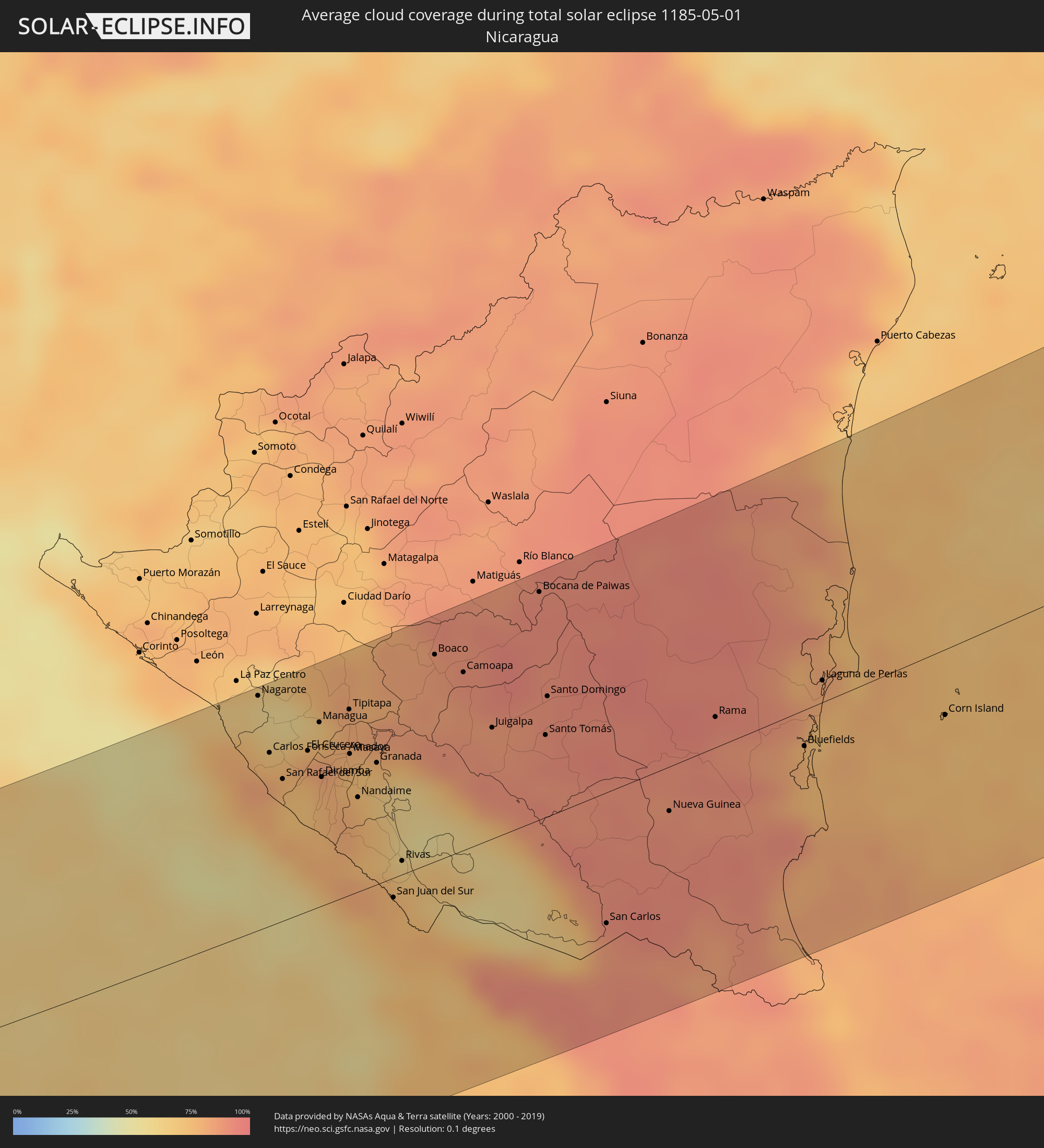 Nicaragua
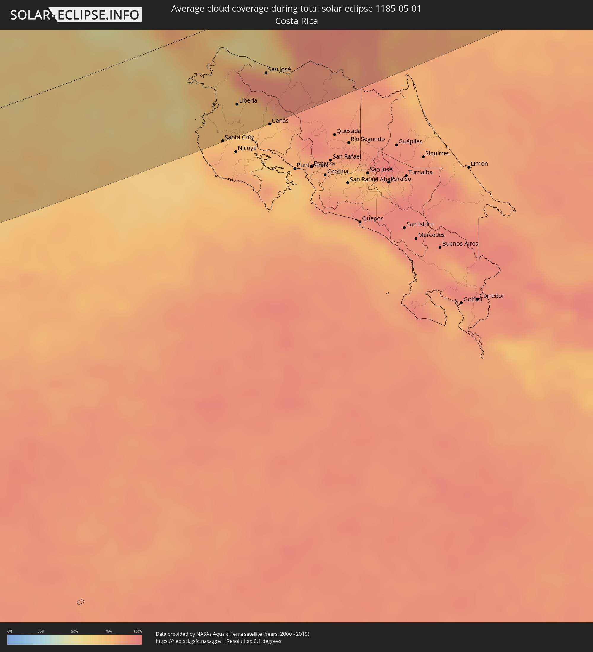 Costa Rica
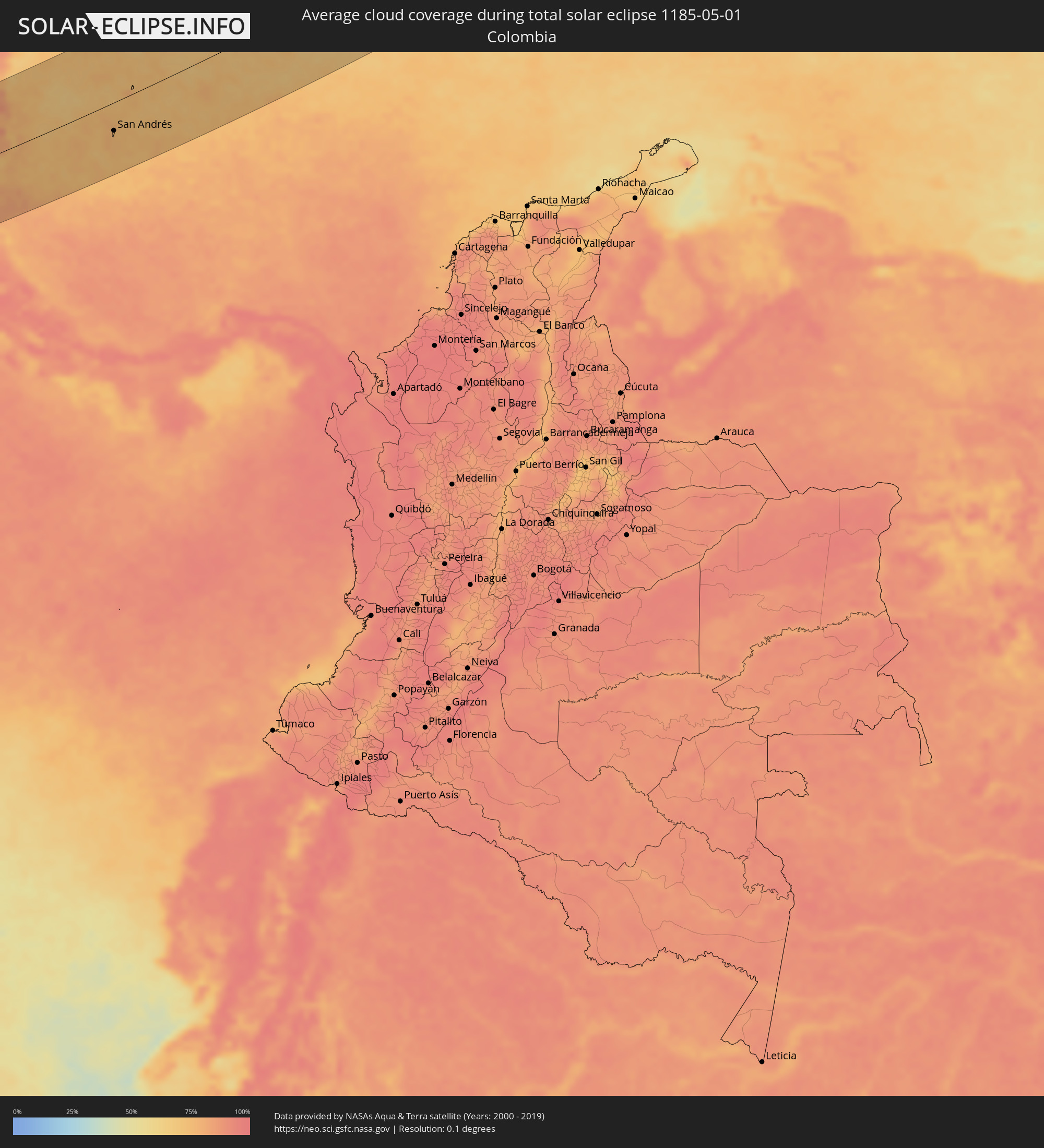 Colombia
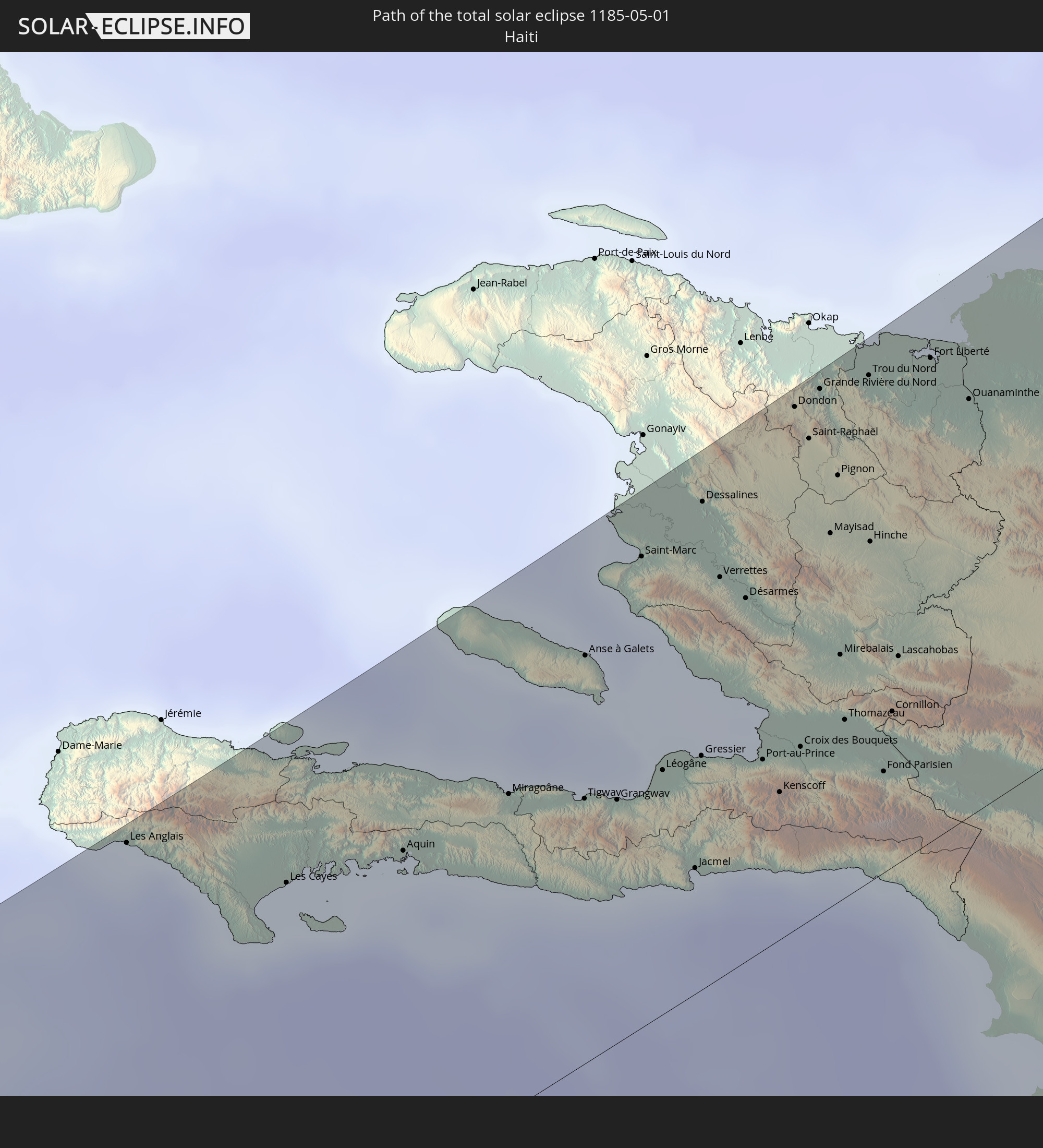
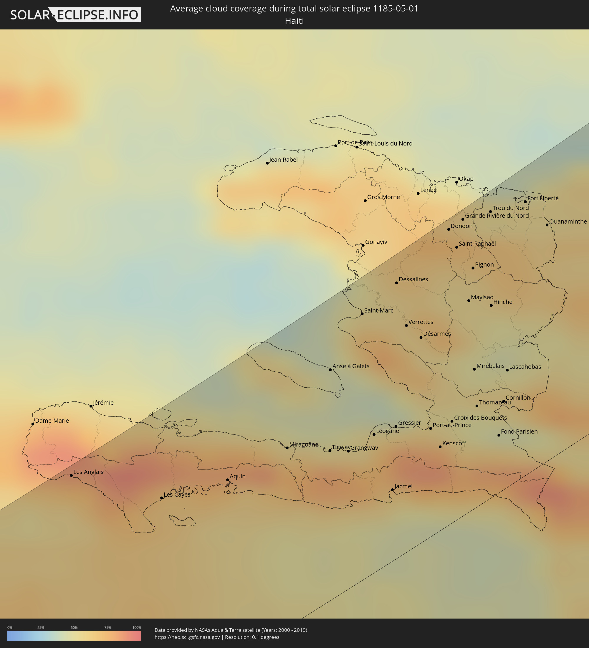 Haiti
Haiti
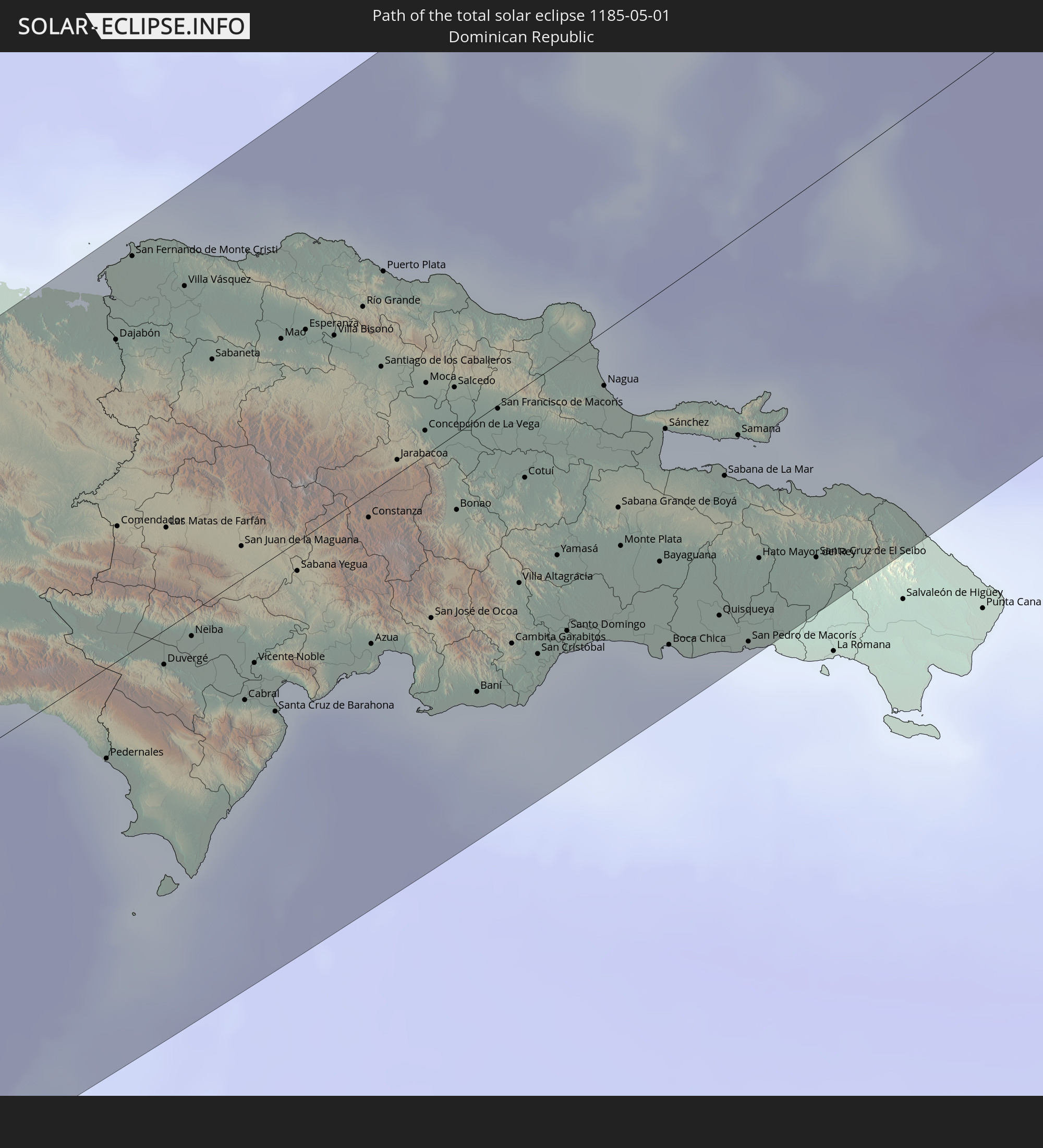
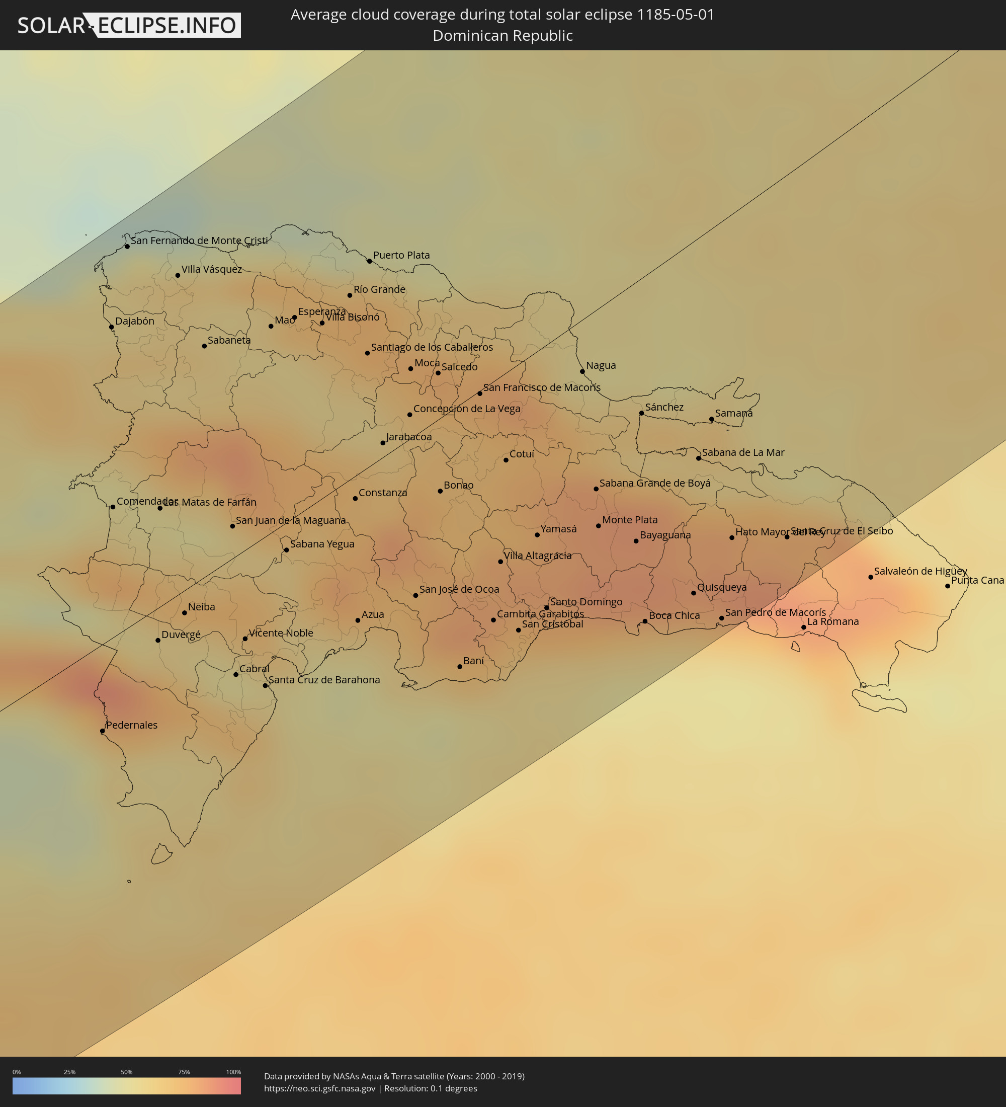 Dominican Republic
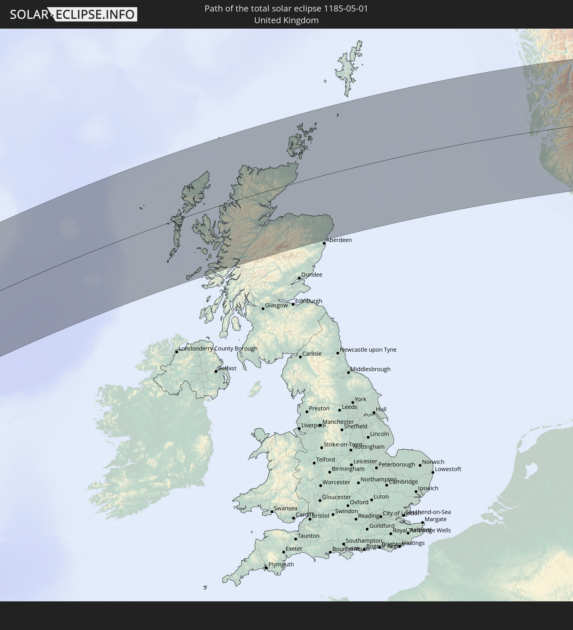
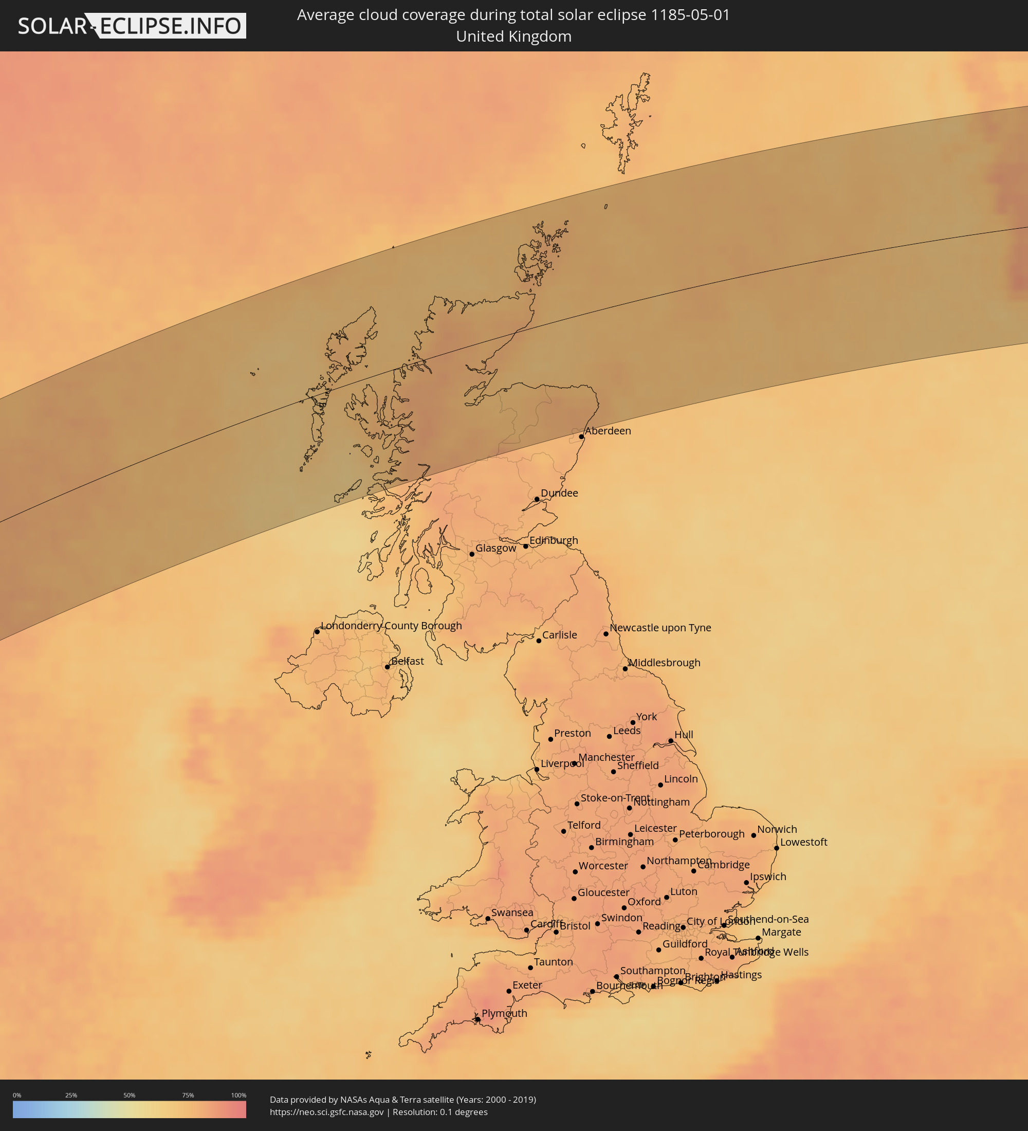 United Kingdom
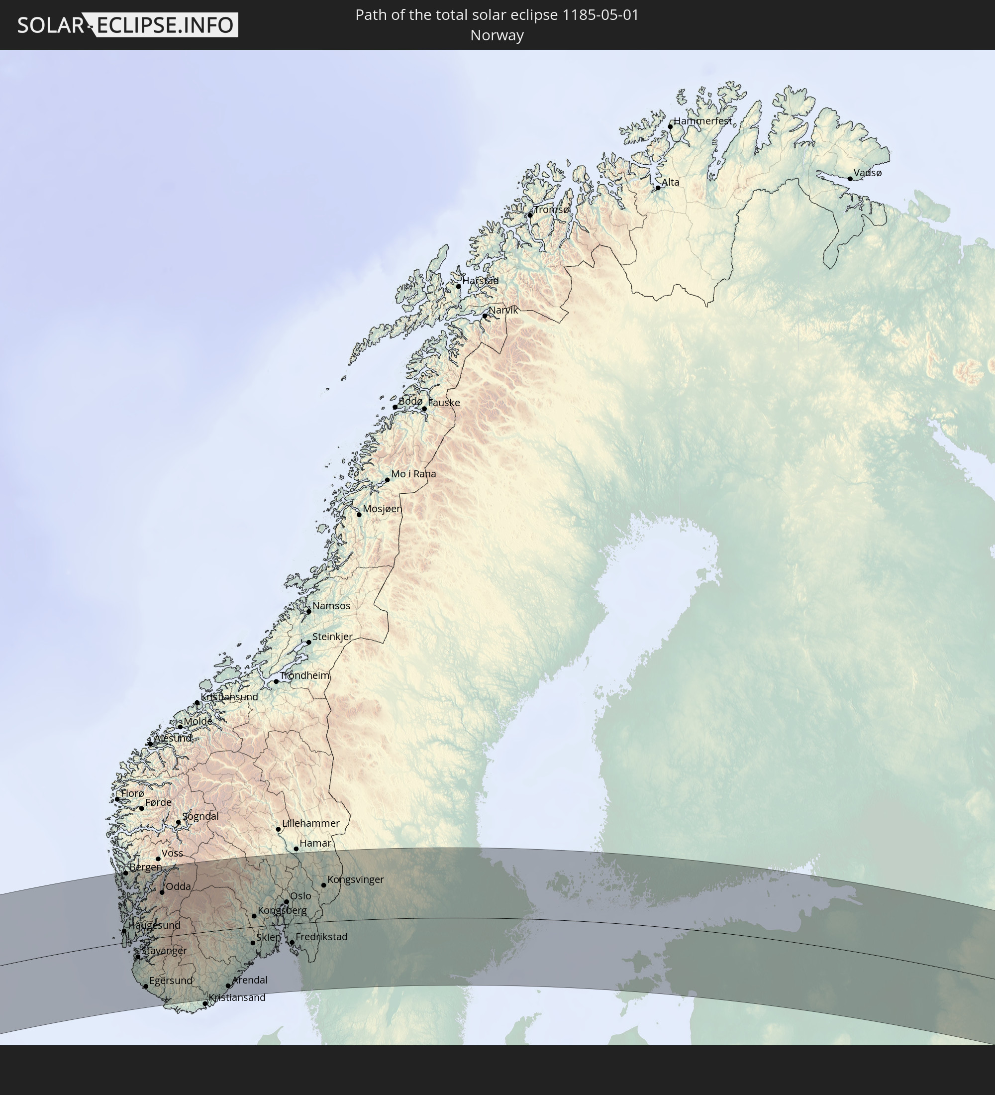
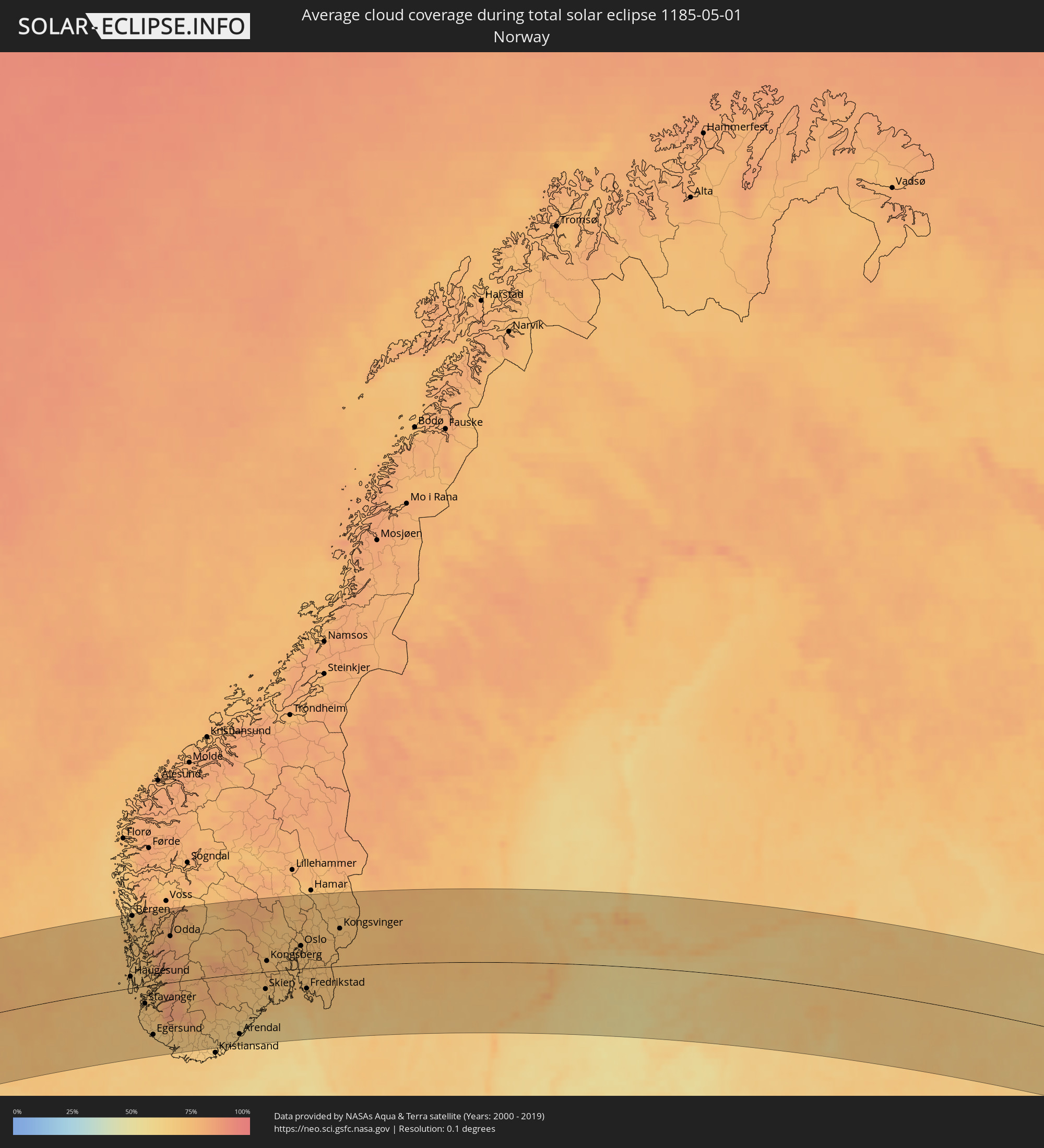 Norway
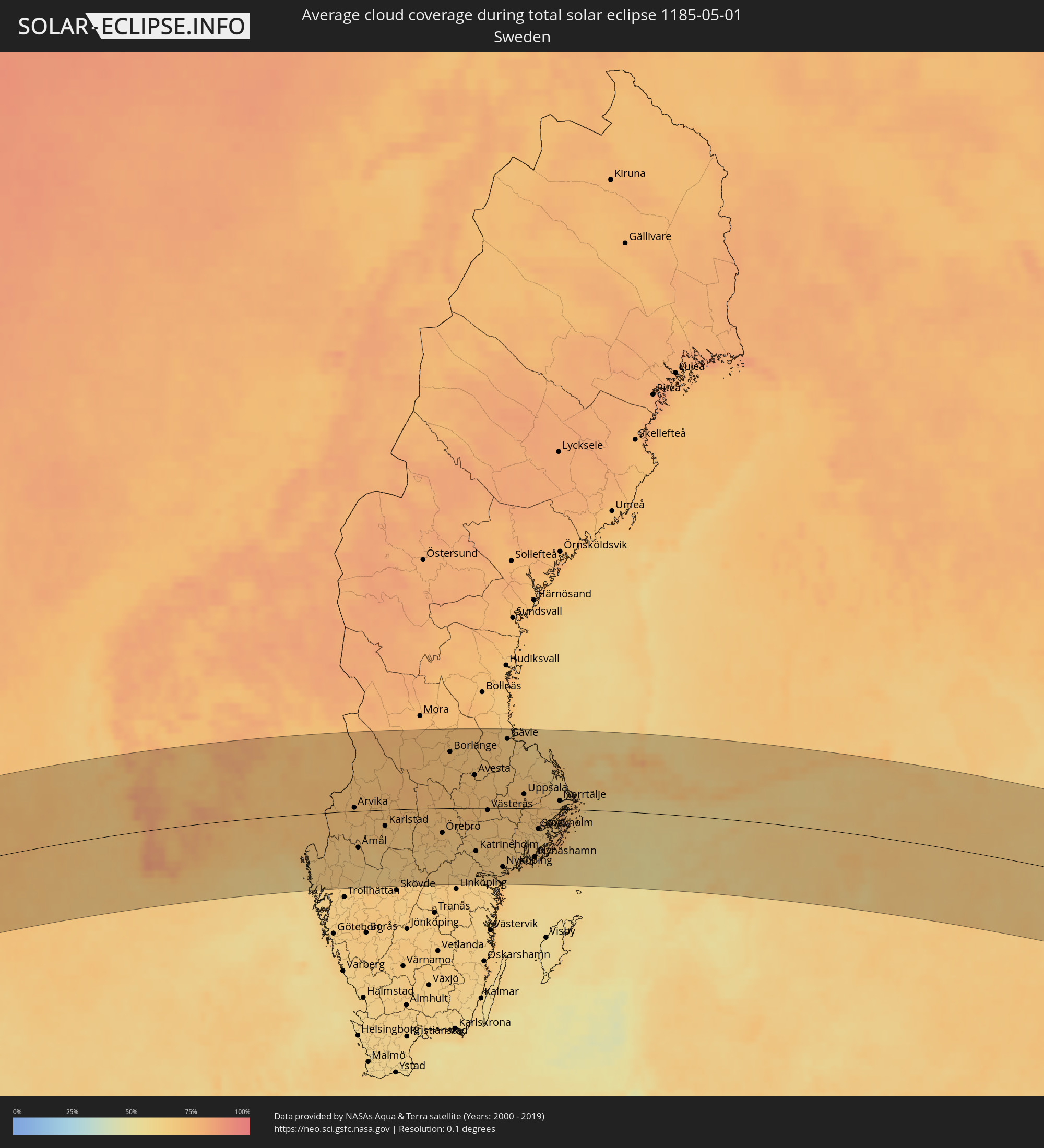 Sweden
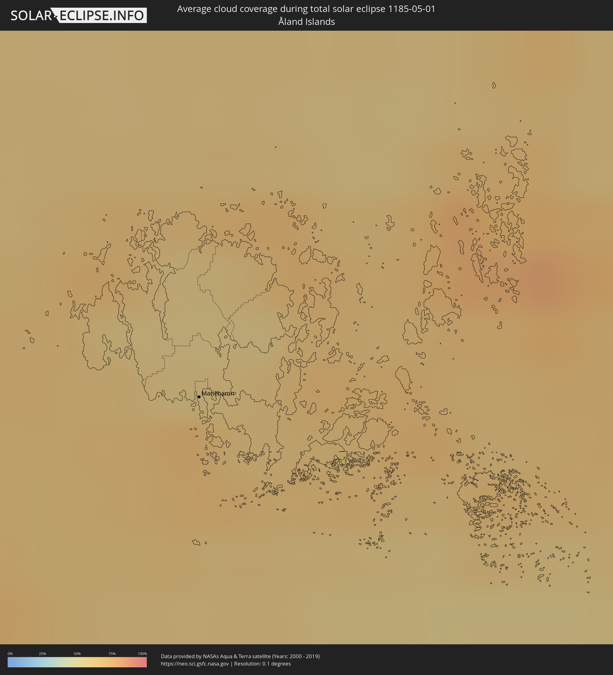 Åland Islands
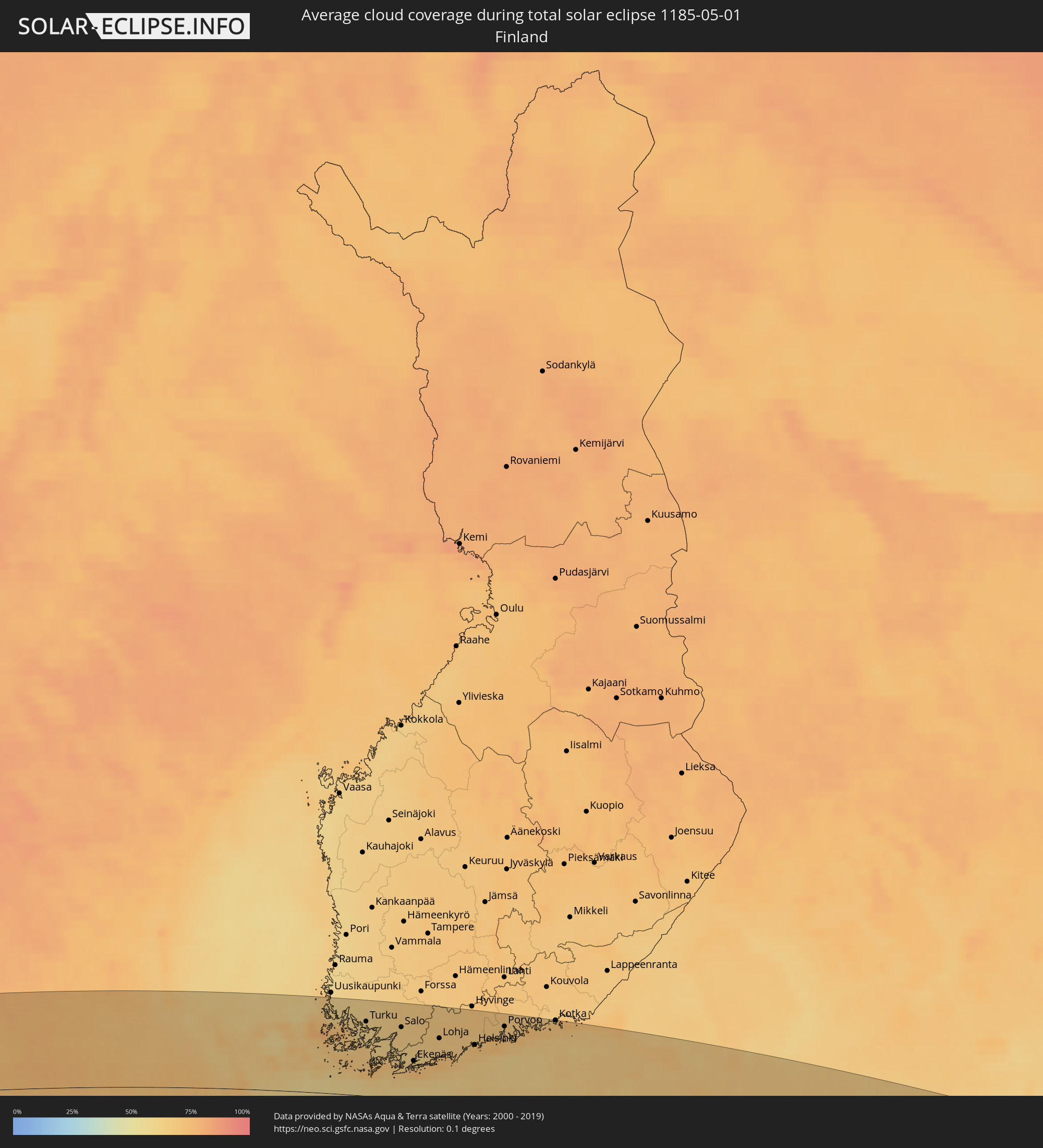 Finland
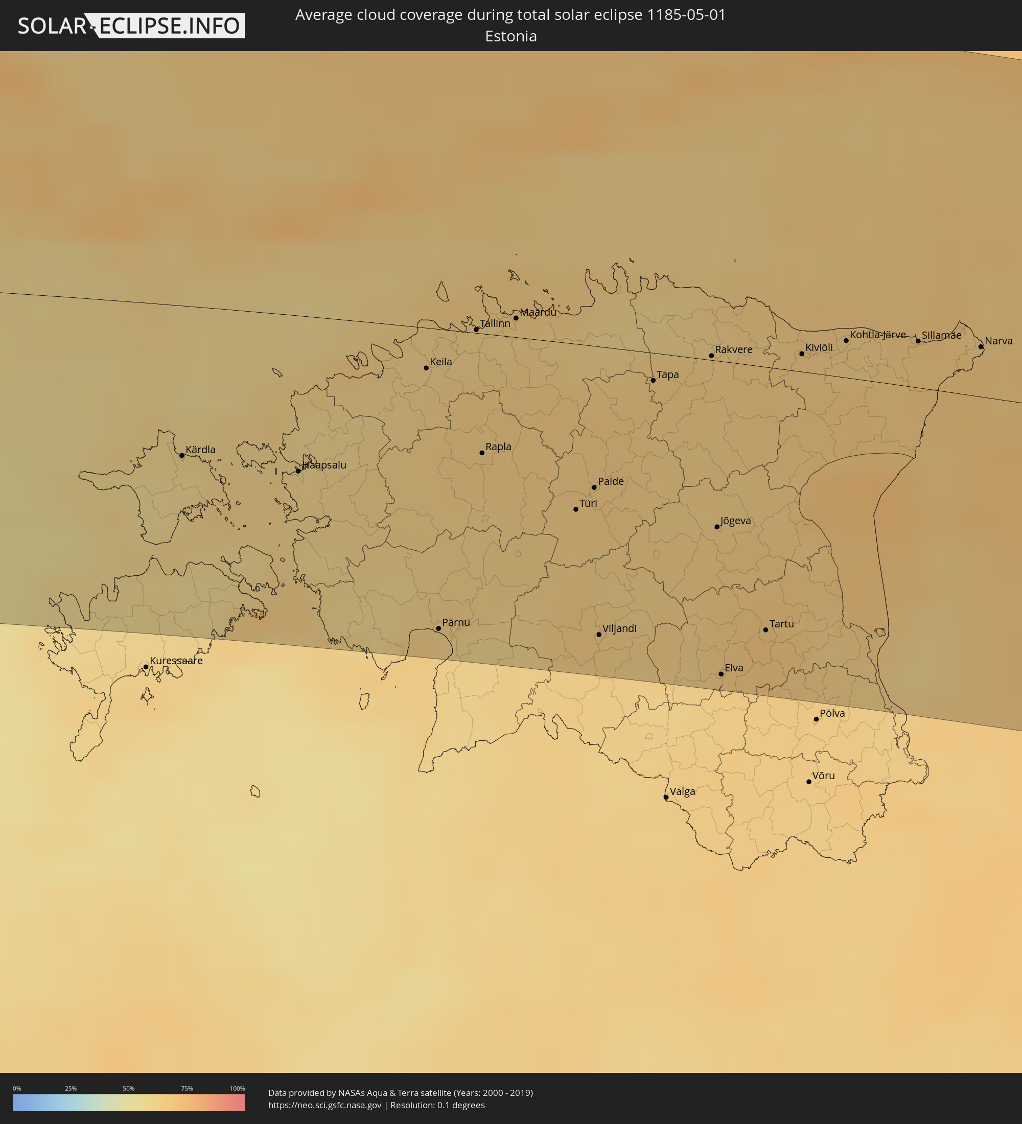 Estonia
 Kazakhstan
Cities inside the path of the eclipse
The following table shows all locations with a population of more than 5,000 inside the eclipse path. Cities which have more than 100,000 inhabitants are marked bold. A click at the locations opens a detailed map.
| City | Type | Eclipse duration | Local time of max. eclipse | Distance to central line | Ø Cloud coverage |
|
Nagarote, León
|
total | - | 06:07:20 UTC-05:45 | 122 km | 65% |
|
San Rafael del Sur, Managua
|
total | - | 06:06:51 UTC-05:45 | 74 km | 74% |
|
El Crucero, Managua
|
total | - | 06:06:59 UTC-05:45 | 84 km | 75% |
|
Managua, Managua
|
total | - | 06:07:08 UTC-05:45 | 96 km | 80% |
|
Diriamba, Carazo
|
total | - | 06:06:49 UTC-05:45 | 67 km | 77% |
|
Tipitapa, Managua
|
total | - | 06:07:11 UTC-05:45 | 97 km | 79% |
|
Masaya, Masaya
|
total | - | 06:06:56 UTC-05:45 | 73 km | 75% |
|
Nandaime, Granada
|
total | - | 06:06:41 UTC-05:45 | 49 km | 80% |
|
Granada, Granada
|
total | - | 06:06:51 UTC-05:45 | 63 km | 73% |
|
Rivas, Rivas
|
total | - | 06:06:18 UTC-05:45 | 7 km | 75% |
|
Boaco, Boaco
|
total | - | 06:07:25 UTC-05:45 | 107 km | 84% |
|
Santa Cruz, Guanacaste
|
total | - | 06:13:59 UTC-05:36 | 124 km | 75% |
|
Camoapa, Boaco
|
total | - | 06:07:18 UTC-05:45 | 92 km | 86% |
|
Liberia, Guanacaste
|
total | - | 06:14:21 UTC-05:36 | 92 km | 76% |
|
Juigalpa, Chontales
|
total | - | 06:06:58 UTC-05:45 | 58 km | 89% |
|
San José, Alajuela
|
total | - | 06:14:39 UTC-05:36 | 71 km | 90% |
|
Nueva Guinea, Atlántico Sur
|
total | - | 06:06:23 UTC-05:45 | 23 km | 92% |
|
Rama, Atlántico Sur
|
total | - | 06:06:53 UTC-05:45 | 16 km | 88% |
|
Bluefields, Atlántico Sur
|
total | - | 06:06:40 UTC-05:45 | 19 km | 78% |
|
San Andrés, Archipiélago de San Andrés, Providencia y Santa Catalina
|
total | - | 06:56:04 UTC-04:56 | 51 km | 75% |
|
Les Cayes, Sud
|
total | - | 07:11:08 UTC-04:49 | 98 km | 65% |
|
Miragoâne, Nippes
|
total | - | 07:11:37 UTC-04:49 | 84 km | 75% |
|
Tigwav, Ouest
|
total | - | 07:11:39 UTC-04:49 | 70 km | 79% |
|
Saint-Marc, Artibonite
|
total | - | 07:12:40 UTC-04:49 | 124 km | 69% |
|
Léogâne, Ouest
|
total | - | 07:11:49 UTC-04:49 | 64 km | 71% |
|
Jacmel, Sud-Est
|
total | - | 07:11:27 UTC-04:49 | 33 km | 51% |
|
Dessalines, Artibonite
|
total | - | 07:12:56 UTC-04:49 | 128 km | 59% |
|
Verrettes, Artibonite
|
total | - | 07:12:39 UTC-04:49 | 105 km | 60% |
|
Désarmes, Artibonite
|
total | - | 07:12:35 UTC-04:49 | 95 km | 58% |
|
Port-au-Prince, Ouest
|
total | - | 07:11:56 UTC-04:49 | 50 km | 78% |
|
Saint-Raphaël, Nord
|
total | - | 07:13:17 UTC-04:49 | 126 km | 57% |
|
Thomazeau, Ouest
|
total | - | 07:12:09 UTC-04:49 | 47 km | 49% |
|
Trou du Nord, Nord-Est
|
total | - | 07:13:35 UTC-04:49 | 132 km | 67% |
|
Hinche, Centre
|
total | - | 07:12:54 UTC-04:49 | 89 km | 51% |
|
Fond Parisien, Ouest
|
total | - | 07:11:58 UTC-04:49 | 26 km | 63% |
|
Fort Liberté, Nord-Est
|
total | - | 07:13:42 UTC-04:49 | 126 km | 55% |
|
San Juan de la Maguana, San Juan
|
total | - | 07:21:36 UTC-04:40 | 11 km | 59% |
|
Santa Cruz de Barahona, Barahona
|
total | - | 07:20:46 UTC-04:40 | 52 km | 59% |
|
Mao, Valverde
|
total | - | 07:22:45 UTC-04:40 | 71 km | 55% |
|
Azua, Azua
|
total | - | 07:21:13 UTC-04:40 | 51 km | 62% |
|
Santiago de los Caballeros, Santiago
|
total | - | 07:22:42 UTC-04:40 | 39 km | 63% |
|
Puerto Plata, Puerto Plata
|
total | - | 07:23:13 UTC-04:40 | 70 km | 63% |
|
Concepción de La Vega, La Vega
|
total | - | 07:22:25 UTC-04:40 | 8 km | 67% |
|
Moca, Espaillat
|
total | - | 07:22:40 UTC-04:40 | 24 km | 70% |
|
Bonao, Monseñor Nouel
|
total | - | 07:22:02 UTC-04:40 | 25 km | 71% |
|
Baní, Peravia
|
total | - | 07:21:05 UTC-04:40 | 91 km | 65% |
|
San Francisco de Macorís, Duarte
|
total | - | 07:22:37 UTC-04:40 | 1 km | 69% |
|
Villa Altagracia, San Cristóbal
|
total | - | 07:21:43 UTC-04:40 | 64 km | 78% |
|
Cotuí, Sánchez Ramírez
|
total | - | 07:22:17 UTC-04:40 | 30 km | 75% |
|
Santo Domingo, Nacional
|
total | - | 07:21:30 UTC-04:40 | 90 km | 75% |
|
Boca Chica, Santo Domingo
|
total | - | 07:21:33 UTC-04:40 | 118 km | 68% |
|
San Pedro de Macorís, San Pedro de Macorís
|
total | - | 07:21:40 UTC-04:40 | 135 km | 68% |
|
Isle of Lewis, Scotland
|
total | - | 14:06:16 UTC+00:00 | 48 km | 72% |
|
Isle of Skye, Scotland
|
total | - | 14:06:27 UTC+00:00 | 45 km | 76% |
|
Fort William, Scotland
|
total | - | 14:07:42 UTC+00:00 | 124 km | 79% |
|
Inverness, Scotland
|
total | - | 14:08:35 UTC+00:00 | 69 km | 74% |
|
Nairn, Scotland
|
total | - | 14:08:55 UTC+00:00 | 64 km | 71% |
|
Forres, Scotland
|
total | - | 14:09:11 UTC+00:00 | 65 km | 73% |
|
Thurso, Scotland
|
total | - | 14:09:07 UTC+00:00 | 39 km | 74% |
|
Elgin, Scotland
|
total | - | 14:09:29 UTC+00:00 | 65 km | 74% |
|
Wick, Scotland
|
total | - | 14:09:34 UTC+00:00 | 16 km | 77% |
|
Buckie, Scotland
|
total | - | 14:09:51 UTC+00:00 | 68 km | 73% |
|
Orkney, Scotland
|
total | - | 14:09:35 UTC+00:00 | 72 km | 76% |
|
Kirkwall, Scotland
|
total | - | 14:09:35 UTC+00:00 | 72 km | 76% |
|
Inverurie, Scotland
|
total | - | 14:10:31 UTC+00:00 | 120 km | 78% |
|
Ellon, Scotland
|
total | - | 14:10:49 UTC+00:00 | 116 km | 79% |
|
Fraserburgh, Scotland
|
total | - | 14:10:48 UTC+00:00 | 82 km | 73% |
|
Peterhead, Scotland
|
total | - | 14:11:04 UTC+00:00 | 104 km | 77% |
|
Haugesund, Rogaland
|
total | - | 15:16:58 UTC+01:00 | 21 km | 66% |
|
Bergen, Hordaland
|
total | - | 15:16:29 UTC+01:00 | 128 km | 66% |
|
Stavanger, Rogaland
|
total | - | 15:17:36 UTC+01:00 | 32 km | 70% |
|
Arendal, Aust-Agder
|
total | - | 15:20:28 UTC+01:00 | 110 km | 64% |
|
Skien, Telemark
|
total | - | 15:20:41 UTC+01:00 | 31 km | 69% |
|
Kongsberg, Buskerud
|
total | - | 15:20:24 UTC+01:00 | 19 km | 72% |
|
Drammen, Buskerud
|
total | - | 15:20:47 UTC+01:00 | 25 km | 72% |
|
Sandefjord, Vestfold
|
total | - | 15:21:13 UTC+01:00 | 43 km | 69% |
|
Hønefoss, Buskerud
|
total | - | 15:20:32 UTC+01:00 | 72 km | 70% |
|
Tønsberg, Vestfold
|
total | - | 15:21:16 UTC+01:00 | 29 km | 70% |
|
Moss, Østfold
|
total | - | 15:21:21 UTC+01:00 | 12 km | 72% |
|
Oslo, Oslo
|
total | - | 15:21:05 UTC+01:00 | 41 km | 74% |
|
Ski, Akershus
|
total | - | 15:21:17 UTC+01:00 | 19 km | 72% |
|
Fredrikstad, Østfold
|
total | - | 15:21:43 UTC+01:00 | 37 km | 72% |
|
Lillestrøm, Akershus
|
total | - | 15:21:17 UTC+01:00 | 45 km | 73% |
|
Halden, Østfold
|
total | - | 15:22:08 UTC+01:00 | 49 km | 69% |
|
Karlstad, Värmland
|
total | - | 15:23:32 UTC+01:00 | 27 km | 69% |
|
Karlskoga, Örebro
|
total | - | 15:24:19 UTC+01:00 | 35 km | 70% |
|
Motala, Östergötland
|
total | - | 15:25:19 UTC+01:00 | 123 km | 66% |
|
Örebro, Örebro
|
total | - | 15:24:50 UTC+01:00 | 41 km | 72% |
|
Borlänge, Dalarna
|
total | - | 15:23:59 UTC+01:00 | 93 km | 73% |
|
Falun, Dalarna
|
total | - | 15:24:01 UTC+01:00 | 106 km | 72% |
|
Norrköping, Östergötland
|
total | - | 15:26:06 UTC+01:00 | 118 km | 67% |
|
Eskilstuna, Södermanland
|
total | - | 15:25:40 UTC+01:00 | 32 km | 69% |
|
Västerås, Västmanland
|
total | - | 15:25:29 UTC+01:00 | 4 km | 71% |
|
Nyköping, Södermanland
|
total | - | 15:26:32 UTC+01:00 | 100 km | 67% |
|
Gävle, Gävleborg
|
total | - | 15:24:56 UTC+01:00 | 114 km | 68% |
|
Södertälje, Stockholm
|
total | - | 15:26:34 UTC+01:00 | 50 km | 68% |
|
Uppsala, Uppsala
|
total | - | 15:25:59 UTC+01:00 | 24 km | 71% |
|
Upplands Väsby, Stockholm
|
total | - | 15:26:28 UTC+01:00 | 14 km | 70% |
|
Stockholm, Stockholm
|
total | - | 15:26:44 UTC+01:00 | 34 km | 66% |
|
Haninge, Stockholm
|
total | - | 15:26:56 UTC+01:00 | 53 km | 66% |
|
Mariehamn, Mariehamns stad
|
total | - | 16:07:01 UTC+01:39 | 54 km | 71% |
|
Turku, Southwest Finland
|
total | - | 16:08:01 UTC+01:39 | 101 km | 61% |
|
Länsi-Turunmaa, Southwest Finland
|
total | - | 16:08:11 UTC+01:39 | 84 km | 61% |
|
Pargas, Southwest Finland
|
total | - | 16:08:11 UTC+01:39 | 85 km | 61% |
|
Paimio, Southwest Finland
|
total | - | 16:08:15 UTC+01:39 | 104 km | 64% |
|
Salo, Southwest Finland
|
total | - | 16:08:34 UTC+01:39 | 97 km | 65% |
|
Ekenäs, Uusimaa
|
total | - | 16:09:08 UTC+01:39 | 53 km | 67% |
|
Haapsalu, Lääne
|
total | - | 16:09:25 UTC+01:39 | 60 km | 62% |
|
Lohja, Uusimaa
|
total | - | 16:09:12 UTC+01:39 | 87 km | 66% |
|
Vihti, Uusimaa
|
total | - | 16:09:09 UTC+01:39 | 107 km | 68% |
|
Keila, Harjumaa
|
total | - | 16:09:32 UTC+01:39 | 16 km | 63% |
|
Pärnu, Pärnumaa
|
total | - | 16:10:31 UTC+01:39 | 117 km | 64% |
|
Espoo, Uusimaa
|
total | - | 16:09:33 UTC+01:39 | 86 km | 69% |
|
Tallinn, Harjumaa
|
total | - | 16:09:35 UTC+01:39 | 1 km | 64% |
|
Nurmijärvi, Uusimaa
|
total | - | 16:09:21 UTC+01:39 | 115 km | 69% |
|
Helsinki, Uusimaa
|
total | - | 16:09:44 UTC+01:39 | 83 km | 70% |
|
Maardu, Harjumaa
|
total | - | 16:09:41 UTC+01:39 | 7 km | 62% |
|
Vantaa, Uusimaa
|
total | - | 16:09:39 UTC+01:39 | 98 km | 66% |
|
Järvenpää, Uusimaa
|
total | - | 16:09:29 UTC+01:39 | 118 km | 68% |
|
Paide, Järvamaa
|
total | - | 16:10:34 UTC+01:39 | 55 km | 65% |
|
Viljandi, Viljandimaa
|
total | - | 16:11:08 UTC+01:39 | 112 km | 65% |
|
Porvoo, Uusimaa
|
total | - | 16:09:52 UTC+01:39 | 112 km | 66% |
|
Tapa, Lääne-Virumaa
|
total | - | 16:10:23 UTC+01:39 | 11 km | 66% |
|
Lovisa, Uusimaa
|
total | - | 16:10:04 UTC+01:39 | 123 km | 68% |
|
Rakvere, Lääne-Virumaa
|
total | - | 16:10:30 UTC+01:39 | 2 km | 65% |
|
Jõgeva, Jõgevamaa
|
total | - | 16:11:09 UTC+01:39 | 64 km | 65% |
|
Tartu, Tartu
|
total | - | 16:11:42 UTC+01:39 | 102 km | 70% |
|
Kotka, Kymenlaakso
|
total | - | 16:10:23 UTC+01:39 | 129 km | 71% |
|
Kiviõli, Ida-Virumaa
|
total | - | 16:10:47 UTC+01:39 | 7 km | 66% |
|
Kohtla-Järve, Ida-Virumaa
|
total | - | 16:10:53 UTC+01:39 | 14 km | 64% |
|
Jõhvi, Ida-Virumaa
|
total | - | 16:11:00 UTC+01:39 | 11 km | 63% |
|
Sillamäe, Ida-Virumaa
|
total | - | 16:11:07 UTC+01:39 | 18 km | 65% |
|
Narva, Ida-Virumaa
|
total | - | 16:11:21 UTC+01:39 | 19 km | 68% |
|
Saint Petersburg, St.-Petersburg
|
total | - | 17:02:57 UTC+02:30 | 100 km | 65% |
|
Cherepovets, Vologda
|
total | - | 17:06:32 UTC+02:30 | 103 km | 66% |
|
Rybinsk, Jaroslavl
|
total | - | 17:08:04 UTC+02:30 | 0 km | 64% |
|
Yaroslavl, Jaroslavl
|
total | - | 17:08:50 UTC+02:30 | 28 km | 65% |
|
Kostroma, Kostroma
|
total | - | 17:08:55 UTC+02:30 | 3 km | 67% |
|
Ivanovo, Ivanovo
|
total | - | 17:09:50 UTC+02:30 | 78 km | 64% |
|
Dzerzhinsk, Nizjnij Novgorod
|
total | - | 17:11:14 UTC+02:30 | 114 km | 63% |
|
Nizhniy Novgorod, Nizjnij Novgorod
|
total | - | 17:11:14 UTC+02:30 | 95 km | 62% |
|
Cheboksary, Chuvashia
|
total | - | 17:11:56 UTC+02:30 | 51 km | 62% |
|
Yoshkar-Ola, Mariy-El
|
total | - | 17:11:25 UTC+02:30 | 15 km | 65% |
|
Kazan, Tatarstan
|
total | - | 17:12:30 UTC+02:30 | 47 km | 65% |
|
Nizhnekamsk, Tatarstan
|
total | - | 17:12:50 UTC+02:30 | 2 km | 66% |
|
Naberezhnyye Chelny, Tatarstan
|
total | - | 17:12:44 UTC+02:30 | 21 km | 66% |
|
Sterlitamak, Bashkortostan
|
total | - | 18:47:16 UTC+04:02 | 107 km | 67% |
|
Ufa, Bashkortostan
|
total | - | 18:46:03 UTC+04:02 | 8 km | 69% |
|
Magnitogorsk, Chelyabinsk
|
total | - | 18:47:14 UTC+04:02 | 44 km | 71% |
|
Dzhetygara, Qostanay
|
total | - | 19:07:32 UTC+04:21 | 108 km | 64% |
|
Komsomolets, Qostanay
|
total | - | 19:05:48 UTC+04:21 | 74 km | 65% |
|
Lisakovsk, Qostanay
|
total | - | 19:06:58 UTC+04:21 | 34 km | 56% |
|
Tobol, Qostanay
|
total | - | 19:06:48 UTC+04:21 | 16 km | 60% |
|
Fedorovka, Qostanay
|
total | - | 19:05:49 UTC+04:21 | 81 km | 66% |
|
Kachar, Qostanay
|
total | - | 19:06:04 UTC+04:21 | 59 km | 61% |
|
Rudnyy, Qostanay
|
total | - | 19:06:25 UTC+04:21 | 27 km | 62% |
|
Kostanay, Qostanay
|
total | - | 19:06:05 UTC+04:21 | 66 km | 59% |
|
Qusmuryn, Qostanay
|
total | - | 19:06:39 UTC+04:21 | 20 km | 64% |
|
Derzhavīnsk, Aqmola
|
total | - | 19:07:35 UTC+04:21 | 62 km | 55% |
|
Esil, Aqmola
|
total | - | 19:06:44 UTC+04:21 | 26 km | 60% |
|
Zhaqsy, Aqmola
|
total | - | 19:06:33 UTC+04:21 | 50 km | 61% |
|
Atbasar, Aqmola
|
total | - | 19:06:22 UTC+04:21 | 73 km | 61% |
|
Astrakhan, Aqmola
|
total | - | 19:06:13 UTC+04:21 | 92 km | 59% |