Totale Sonnenfinsternis vom 14.09.1205
| Wochentag: | Mittwoch |
| Maximale Dauer der Verfinsterung: | 03m55s |
| Maximale Breite des Finsternispfades: | 270 km |
| Saroszyklus: | 102 |
| Bedeckungsgrad: | 100% |
| Magnitude: | 1.0556 |
| Gamma: | 0.7458 |
Wo kann man die Sonnenfinsternis vom 14.09.1205 sehen?
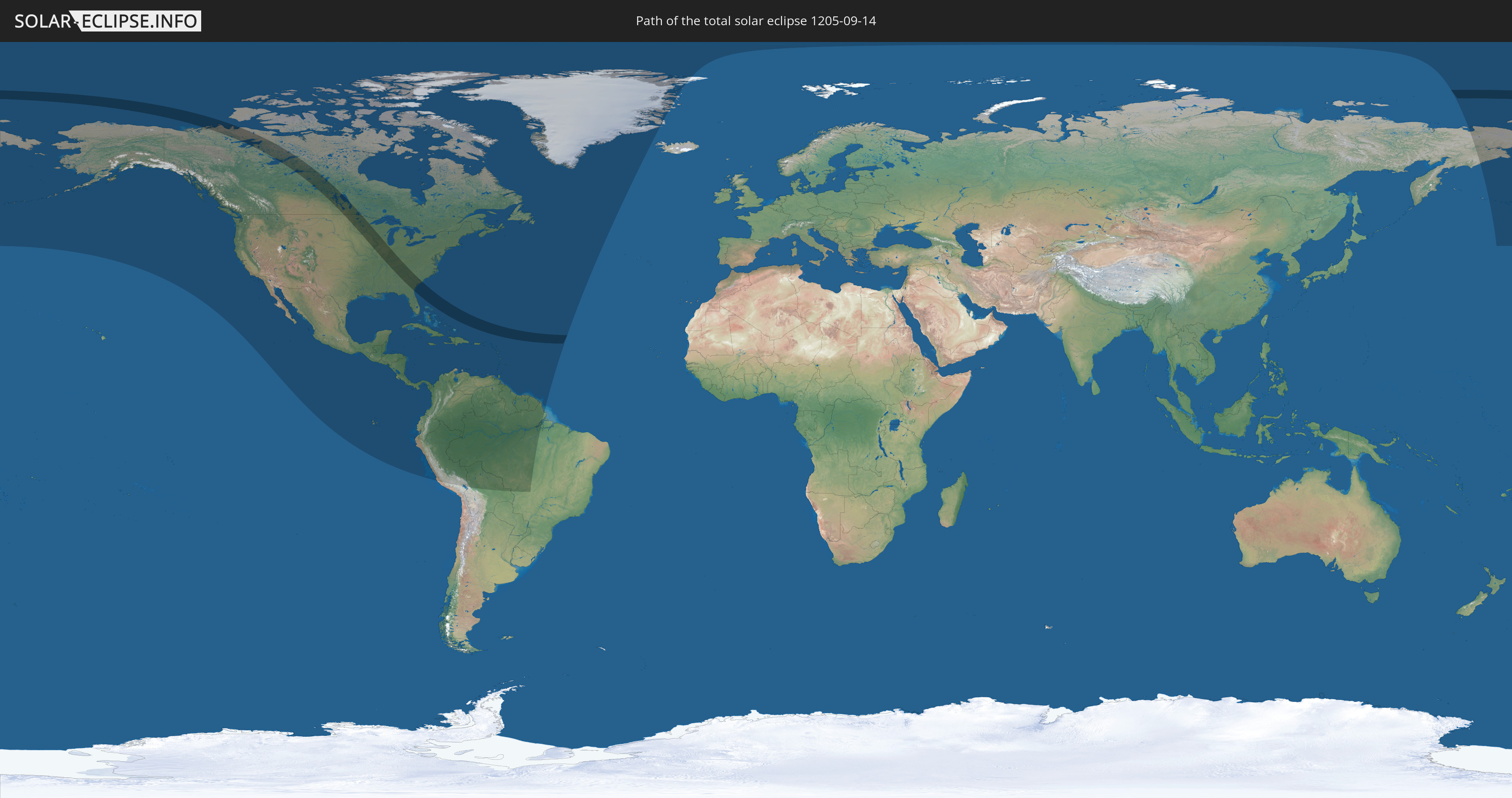
Die Sonnenfinsternis am 14.09.1205 kann man in 49 Ländern als partielle Sonnenfinsternis beobachten.
Der Finsternispfad verläuft durch 2 Länder. Nur in diesen Ländern ist sie als totale Sonnenfinsternis zu sehen.
In den folgenden Ländern ist die Sonnenfinsternis total zu sehen
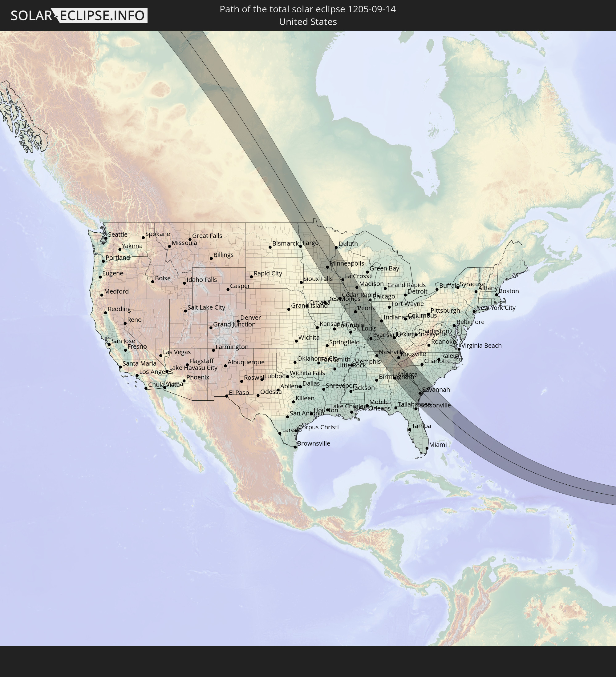 Vereinigte Staaten
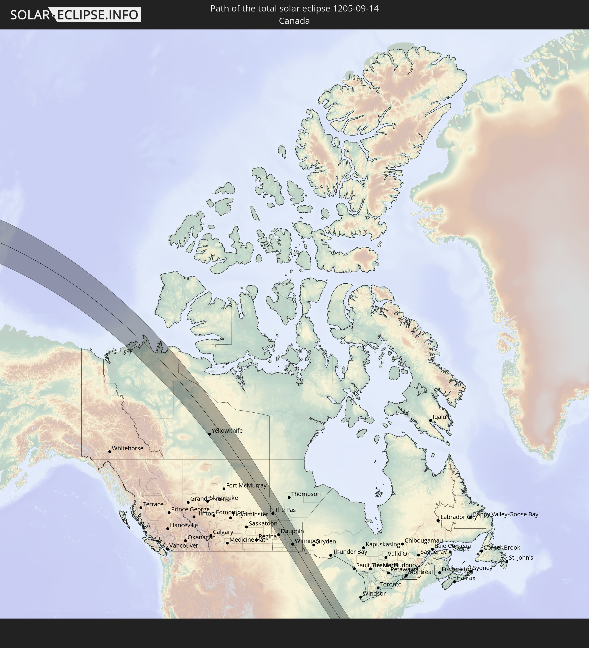 Kanada
In den folgenden Ländern ist die Sonnenfinsternis partiell zu sehen
 Russland
 Vereinigte Staaten
 United States Minor Outlying Islands
 Kanada
 Mexiko
 Grönland
 Guatemala
 Ecuador
 El Salvador
 Honduras
 Belize
 Nicaragua
 Costa Rica
 Kuba
Kuba
 Panama
 Kolumbien
 Kaimaninseln
 Peru
Peru
 Bahamas
 Jamaika
 Haiti
Haiti
 Brasilien
 Venezuela
 Turks- und Caicosinseln
 Dominikanische Republik
 Aruba
Aruba
 Bolivien
 Puerto Rico
 Amerikanische Jungferninseln
 Bermuda
 Britische Jungferninseln
 Anguilla
 Saint-Martin
 Saint-Barthélemy
 St. Kitts und Nevis
 Antigua und Barbuda
 Montserrat
 Trinidad und Tobago
 Guadeloupe
 Grenada
 Dominica
 St. Vincent und die Grenadinen
 Guyana
 Martinique
 St. Lucia
 Barbados
 Suriname
 Saint-Pierre und Miquelon
 Französisch-Guayana
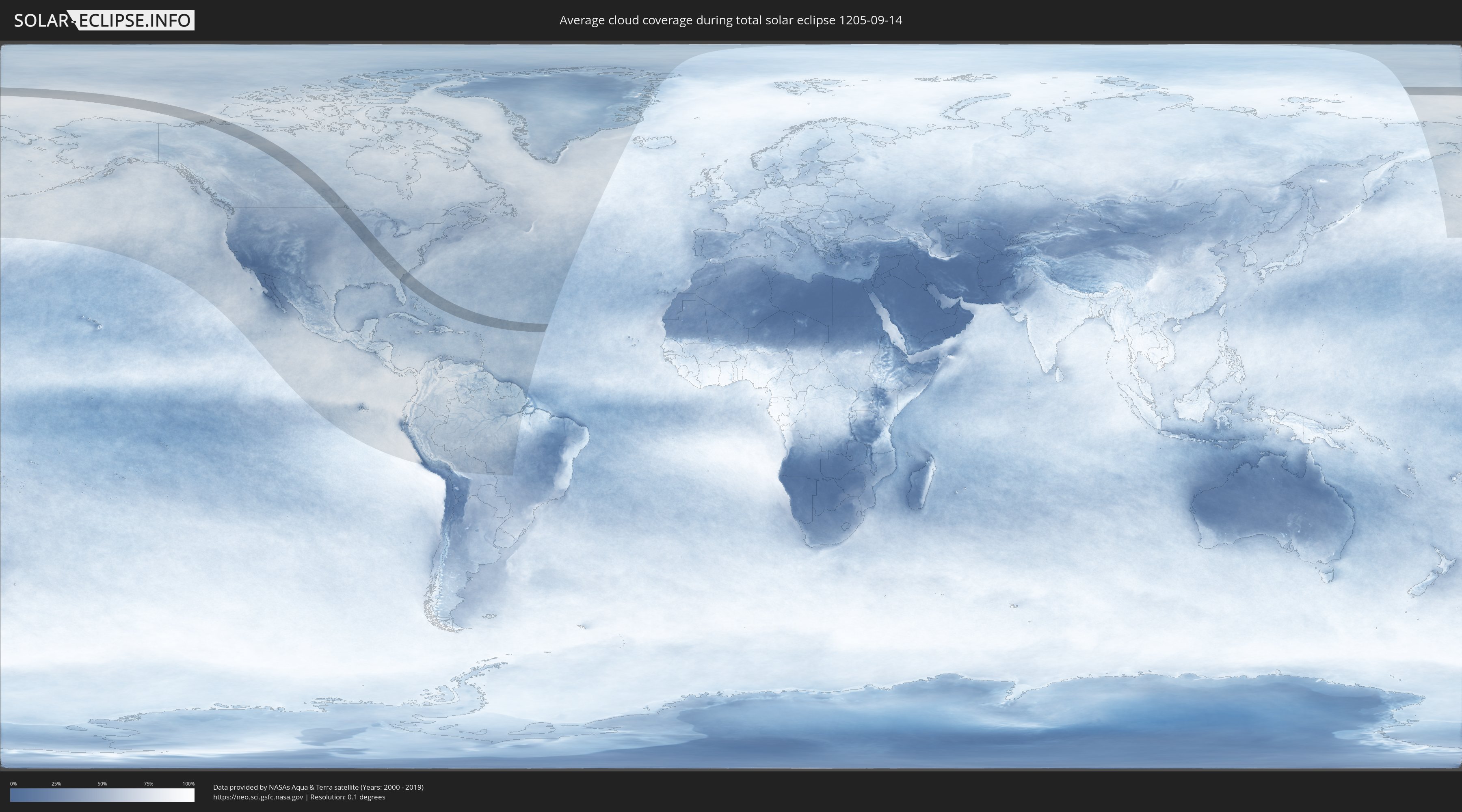
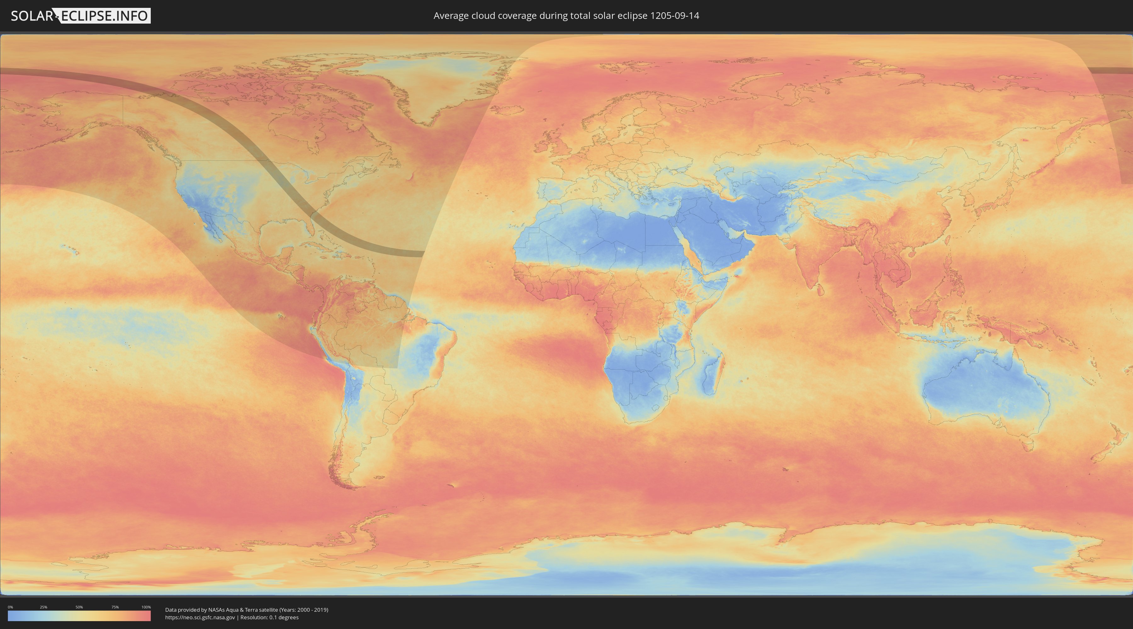
Wie wird das Wetter während der totalen Sonnenfinsternis am 14.09.1205?
Wo ist der beste Ort, um die totale Sonnenfinsternis vom 14.09.1205 zu beobachten?
Die folgenden Karten zeigen die durchschnittliche Bewölkung für den Tag, an dem die totale Sonnenfinsternis
stattfindet. Mit Hilfe der Karten lässt sich der Ort entlang des Finsternispfades eingrenzen,
der die besten Aussichen auf einen klaren wolkenfreien Himmel bietet.
Trotzdem muss man immer lokale Gegenenheiten beachten und sollte sich genau über das Wetter an seinem
gewählten Beobachtungsort informieren.
Die Daten stammen von den beiden NASA-Satelliten
AQUA und TERRA
und wurden über einen Zeitraum von 19 Jahren (2000 - 2019) gemittelt.
Detaillierte Länderkarten
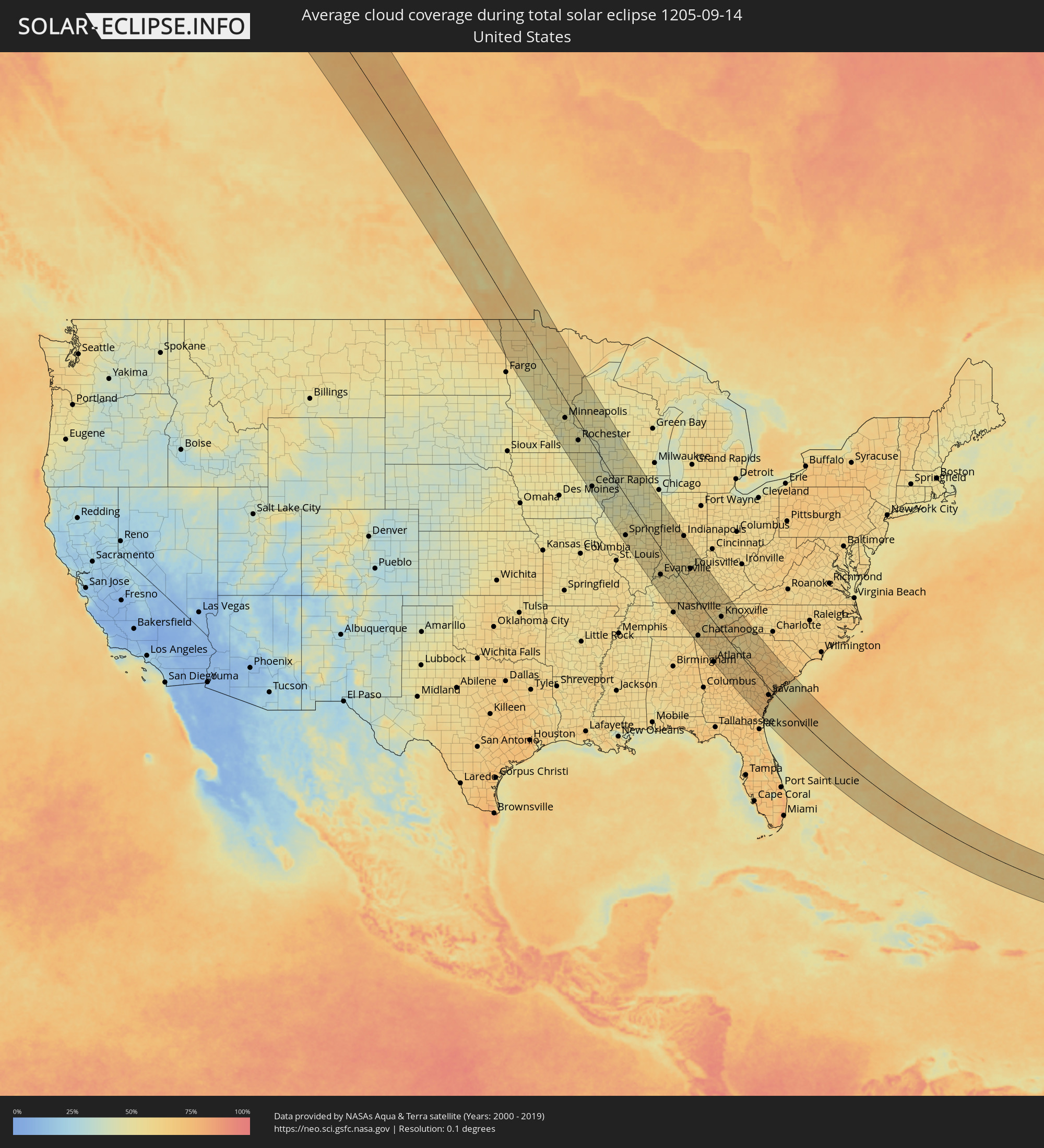 Vereinigte Staaten
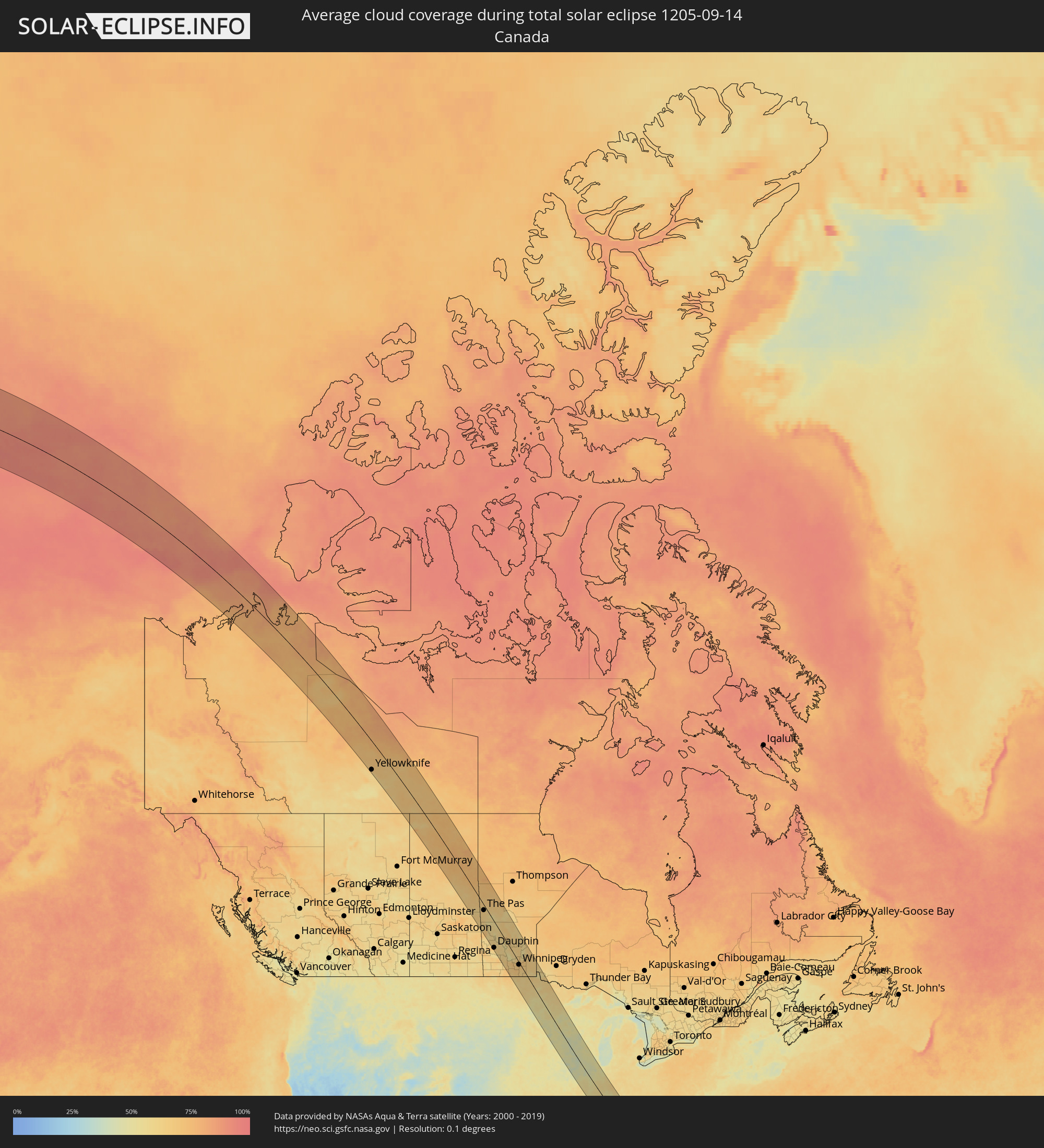 Kanada
Orte im Finsternispfad
Die nachfolgene Tabelle zeigt Städte und Orte mit mehr als 5.000 Einwohnern, die sich im Finsternispfad befinden. Städte mit mehr als 100.000 Einwohnern sind dick gekennzeichnet. Mit einem Klick auf den Ort öffnet sich eine Detailkarte die die Lage des jeweiligen Ortes zusammen mit dem Verlauf der zentralen Finsternis präsentiert.
| Ort | Typ | Dauer der Verfinsterung | Ortszeit bei maximaler Verfinsterung | Entfernung zur Zentrallinie | Ø Bewölkung |
|
Yellowknife, Northwest Territories
|
total | - | 11:22:18 UTC-07:33 | 103 km | 66% |
|
Flin Flon, Manitoba
|
total | - | 13:13:14 UTC-06:00 | 1 km | 68% |
|
The Pas, Manitoba
|
total | - | 13:14:52 UTC-06:00 | 21 km | 68% |
|
Dauphin, Manitoba
|
total | - | 13:19:17 UTC-06:00 | 110 km | 67% |
|
Portage la Prairie, Manitoba
|
total | - | 13:22:44 UTC-06:00 | 75 km | 65% |
|
Morden, Manitoba
|
total | - | 13:24:00 UTC-06:00 | 109 km | 64% |
|
Winkler, Manitoba
|
total | - | 13:24:12 UTC-06:00 | 100 km | 63% |
|
Winnipeg, Manitoba
|
total | - | 13:24:09 UTC-06:00 | 10 km | 67% |
|
Grand Forks, North Dakota
|
total | - | 13:26:58 UTC-06:00 | 117 km | 60% |
|
Selkirk, Manitoba
|
total | - | 13:24:05 UTC-06:00 | 21 km | 63% |
|
Steinbach, Manitoba
|
total | - | 13:25:09 UTC-06:00 | 2 km | 64% |
|
Saint Cloud, Minnesota
|
total | - | 13:33:51 UTC-06:00 | 71 km | 48% |
|
Shakopee, Minnesota
|
total | - | 13:35:48 UTC-06:00 | 73 km | 45% |
|
Plymouth, Minnesota
|
total | - | 13:35:33 UTC-06:00 | 56 km | 47% |
|
West Coon Rapids, Minnesota
|
total | - | 13:35:26 UTC-06:00 | 40 km | 50% |
|
Bloomington, Minnesota
|
total | - | 13:36:00 UTC-06:00 | 56 km | 49% |
|
Minneapolis, Minnesota
|
total | - | 13:35:49 UTC-06:00 | 45 km | 49% |
|
Lakeville, Minnesota
|
total | - | 13:36:22 UTC-06:00 | 63 km | 50% |
|
Owatonna, Minnesota
|
total | - | 13:37:18 UTC-06:00 | 96 km | 49% |
|
White Bear Lake, Minnesota
|
total | - | 13:35:57 UTC-06:00 | 22 km | 46% |
|
Austin, Minnesota
|
total | - | 13:38:16 UTC-06:00 | 104 km | 47% |
|
Woodbury, Minnesota
|
total | - | 13:36:16 UTC-06:00 | 28 km | 47% |
|
Rochester, Minnesota
|
total | - | 13:38:18 UTC-06:00 | 48 km | 47% |
|
Waterloo, Iowa
|
total | - | 13:40:58 UTC-06:00 | 131 km | 49% |
|
Cedar Rapids, Iowa
|
total | - | 13:42:38 UTC-06:00 | 113 km | 43% |
|
Winona, Minnesota
|
total | - | 13:39:14 UTC-06:00 | 10 km | 45% |
|
Iowa City, Iowa
|
total | - | 13:43:22 UTC-06:00 | 126 km | 47% |
|
Eau Claire, Wisconsin
|
total | - | 13:38:10 UTC-06:00 | 64 km | 47% |
|
La Crosse, Wisconsin
|
total | - | 13:40:07 UTC-06:00 | 23 km | 42% |
|
Dubuque, Iowa
|
total | - | 13:42:58 UTC-06:00 | 15 km | 45% |
|
Davenport, Iowa
|
total | - | 13:44:45 UTC-06:00 | 68 km | 40% |
|
Galesburg, Illinois
|
total | - | 13:45:59 UTC-06:00 | 89 km | 45% |
|
Clinton, Iowa
|
total | - | 13:44:40 UTC-06:00 | 21 km | 43% |
|
Springfield, Illinois
|
total | - | 13:48:53 UTC-06:00 | 109 km | 52% |
|
Freeport, Illinois
|
total | - | 13:44:33 UTC-06:00 | 45 km | 47% |
|
Peoria, Illinois
|
total | - | 13:47:22 UTC-06:00 | 50 km | 49% |
|
Madison, Wisconsin
|
total | - | 13:43:30 UTC-06:00 | 106 km | 46% |
|
Sun Prairie, Wisconsin
|
total | - | 13:43:31 UTC-06:00 | 126 km | 52% |
|
Rockford, Illinois
|
total | - | 13:45:13 UTC-06:00 | 80 km | 49% |
|
Beloit, Wisconsin
|
total | - | 13:44:53 UTC-06:00 | 99 km | 49% |
|
Janesville, Wisconsin
|
total | - | 13:44:36 UTC-06:00 | 110 km | 51% |
|
Bloomington, Illinois
|
total | - | 13:48:27 UTC-06:00 | 21 km | 50% |
|
Decatur, Illinois
|
total | - | 13:49:38 UTC-06:00 | 58 km | 54% |
|
Belvidere, Illinois
|
total | - | 13:45:31 UTC-06:00 | 97 km | 48% |
|
DeKalb, Illinois
|
total | - | 13:46:13 UTC-06:00 | 84 km | 45% |
|
Aurora, Illinois
|
total | - | 13:47:01 UTC-06:00 | 104 km | 49% |
|
Crystal Lake, Illinois
|
total | - | 13:46:11 UTC-06:00 | 133 km | 47% |
|
Elgin, Illinois
|
total | - | 13:46:34 UTC-06:00 | 123 km | 48% |
|
Champaign, Illinois
|
total | - | 13:50:00 UTC-06:00 | 10 km | 53% |
|
Wheaton, Illinois
|
total | - | 13:47:04 UTC-06:00 | 125 km | 49% |
|
Joliet, Illinois
|
total | - | 13:47:42 UTC-06:00 | 107 km | 49% |
|
Bolingbrook, Illinois
|
total | - | 13:47:25 UTC-06:00 | 118 km | 50% |
|
Kankakee, Illinois
|
total | - | 13:48:40 UTC-06:00 | 98 km | 51% |
|
Orland Park, Illinois
|
total | - | 13:47:47 UTC-06:00 | 129 km | 51% |
|
Danville, Illinois
|
total | - | 13:50:42 UTC-06:00 | 54 km | 56% |
|
Henderson, Kentucky
|
total | - | 13:54:53 UTC-06:00 | 88 km | 57% |
|
Evansville, Indiana
|
total | - | 13:54:40 UTC-06:00 | 77 km | 51% |
|
Terre Haute, Indiana
|
total | - | 14:52:08 UTC-05:00 | 28 km | 53% |
|
Owensboro, Kentucky
|
total | - | 13:55:34 UTC-06:00 | 58 km | 54% |
|
Lafayette, Indiana
|
total | - | 14:51:04 UTC-05:00 | 125 km | 58% |
|
Hendersonville, Tennessee
|
total | - | 13:58:52 UTC-06:00 | 120 km | 57% |
|
Bloomington, Indiana
|
total | - | 14:53:43 UTC-05:00 | 73 km | 51% |
|
Smyrna, Tennessee
|
total | - | 13:59:35 UTC-06:00 | 134 km | 61% |
|
Gallatin, Tennessee
|
total | - | 13:58:55 UTC-06:00 | 102 km | 55% |
|
Bowling Green, Kentucky
|
total | - | 13:57:48 UTC-06:00 | 61 km | 60% |
|
Plainfield, Indiana
|
total | - | 14:52:54 UTC-05:00 | 115 km | 61% |
|
Murfreesboro, Tennessee
|
total | - | 14:00:00 UTC-06:00 | 134 km | 60% |
|
Lebanon, Tennessee
|
total | - | 13:59:26 UTC-06:00 | 103 km | 61% |
|
Indianapolis, Indiana
|
total | - | 14:53:03 UTC-05:00 | 136 km | 61% |
|
Greenwood, Indiana
|
total | - | 14:53:24 UTC-05:00 | 130 km | 59% |
|
Franklin, Indiana
|
total | - | 14:53:42 UTC-05:00 | 126 km | 59% |
|
Columbus, Indiana
|
total | - | 14:54:21 UTC-05:00 | 118 km | 57% |
|
Elizabethtown, Kentucky
|
total | - | 14:57:11 UTC-05:00 | 26 km | 56% |
|
Louisville, Kentucky
|
total | - | 14:56:16 UTC-05:00 | 70 km | 57% |
|
Jeffersontown, Kentucky
|
total | - | 14:56:37 UTC-05:00 | 80 km | 59% |
|
Cookeville, Tennessee
|
total | - | 14:00:27 UTC-06:00 | 49 km | 63% |
|
Chattanooga, Tennessee
|
total | - | 15:02:46 UTC-05:00 | 112 km | 61% |
|
Dalton, Georgia
|
total | - | 15:03:41 UTC-05:00 | 106 km | 62% |
|
Cleveland, Tennessee
|
total | - | 15:03:03 UTC-05:00 | 73 km | 64% |
|
Frankfort, Kentucky
|
total | - | 14:57:24 UTC-05:00 | 130 km | 60% |
|
Nicholasville, Kentucky
|
total | - | 14:58:20 UTC-05:00 | 131 km | 57% |
|
Marietta, Georgia
|
total | - | 15:05:43 UTC-05:00 | 134 km | 66% |
|
Woodstock, Georgia
|
total | - | 15:05:28 UTC-05:00 | 121 km | 64% |
|
Atlanta, Georgia
|
total | - | 15:06:17 UTC-05:00 | 137 km | 69% |
|
Sandy Springs, Georgia
|
total | - | 15:05:58 UTC-05:00 | 124 km | 67% |
|
Oak Ridge, Tennessee
|
total | - | 15:02:09 UTC-05:00 | 29 km | 56% |
|
Stockbridge, Georgia
|
total | - | 15:06:51 UTC-05:00 | 141 km | 66% |
|
Johns Creek, Georgia
|
total | - | 15:05:59 UTC-05:00 | 104 km | 68% |
|
Redan, Georgia
|
total | - | 15:06:35 UTC-05:00 | 119 km | 66% |
|
Lawrenceville, Georgia
|
total | - | 15:06:21 UTC-05:00 | 94 km | 68% |
|
Maryville, Tennessee
|
total | - | 15:02:59 UTC-05:00 | 33 km | 61% |
|
Knoxville, Tennessee
|
total | - | 15:02:39 UTC-05:00 | 50 km | 58% |
|
Gainesville, Georgia
|
total | - | 15:05:54 UTC-05:00 | 58 km | 59% |
|
Athens, Georgia
|
total | - | 15:07:03 UTC-05:00 | 50 km | 63% |
|
Morristown, Tennessee
|
total | - | 15:02:53 UTC-05:00 | 112 km | 55% |
|
Anderson, South Carolina
|
total | - | 15:06:50 UTC-05:00 | 40 km | 58% |
|
Asheville, North Carolina
|
total | - | 15:04:52 UTC-05:00 | 123 km | 60% |
|
Greenville, South Carolina
|
total | - | 15:06:28 UTC-05:00 | 83 km | 62% |
|
Greer, South Carolina
|
total | - | 15:06:29 UTC-05:00 | 101 km | 62% |
|
Evans, Georgia
|
total | - | 15:09:15 UTC-05:00 | 7 km | 70% |
|
Augusta, Georgia
|
total | - | 15:09:33 UTC-05:00 | 14 km | 67% |
|
Spartanburg, South Carolina
|
total | - | 15:06:47 UTC-05:00 | 122 km | 59% |
|
Statesboro, Georgia
|
total | - | 15:11:42 UTC-05:00 | 48 km | 68% |
|
Aiken, South Carolina
|
total | - | 15:09:40 UTC-05:00 | 38 km | 71% |
|
Hinesville, Georgia
|
total | - | 15:13:04 UTC-05:00 | 80 km | 68% |
|
Savannah, Georgia
|
total | - | 15:13:09 UTC-05:00 | 28 km | 75% |
|
Columbia, South Carolina
|
total | - | 15:09:34 UTC-05:00 | 118 km | 69% |
|
Hilton Head Island, South Carolina
|
total | - | 15:13:17 UTC-05:00 | 6 km | 59% |
|
Summerville, South Carolina
|
total | - | 15:12:22 UTC-05:00 | 106 km | 70% |
|
Charleston, South Carolina
|
total | - | 15:13:05 UTC-05:00 | 105 km | 63% |