Totale Sonnenfinsternis vom 17.11.1286
| Wochentag: | Sonntag |
| Maximale Dauer der Verfinsterung: | 04m17s |
| Maximale Breite des Finsternispfades: | 168 km |
| Saroszyklus: | 121 |
| Bedeckungsgrad: | 100% |
| Magnitude: | 1.0441 |
| Gamma: | 0.4865 |
Wo kann man die Sonnenfinsternis vom 17.11.1286 sehen?
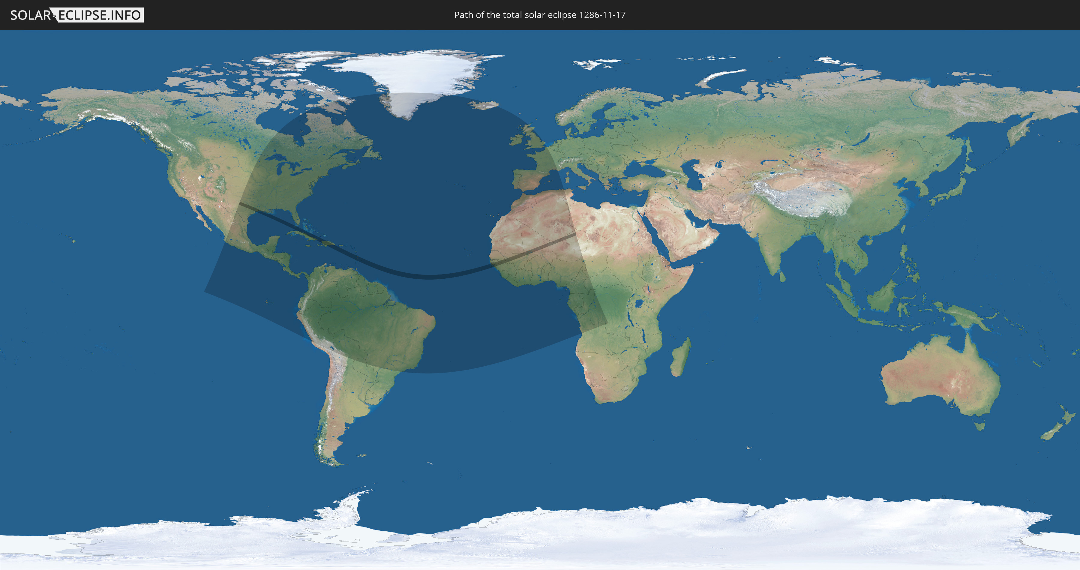
Die Sonnenfinsternis am 17.11.1286 kann man in 90 Ländern als partielle Sonnenfinsternis beobachten.
Der Finsternispfad verläuft durch 16 Länder. Nur in diesen Ländern ist sie als totale Sonnenfinsternis zu sehen.
In den folgenden Ländern ist die Sonnenfinsternis total zu sehen
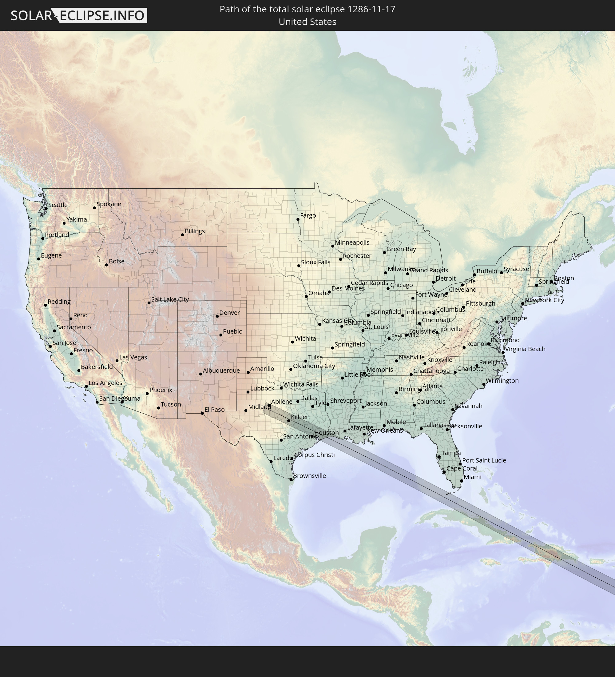 Vereinigte Staaten
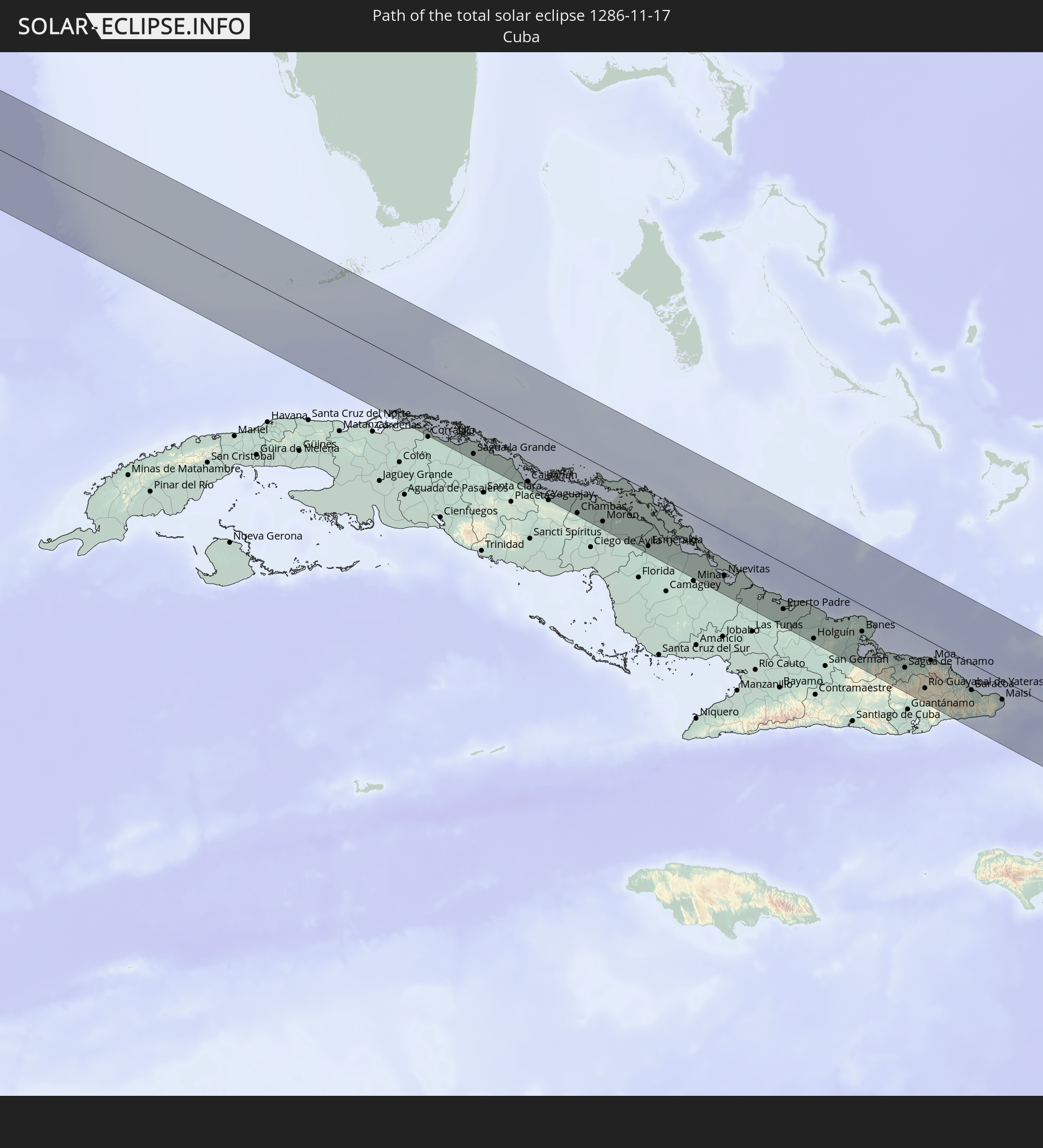 Kuba
Kuba
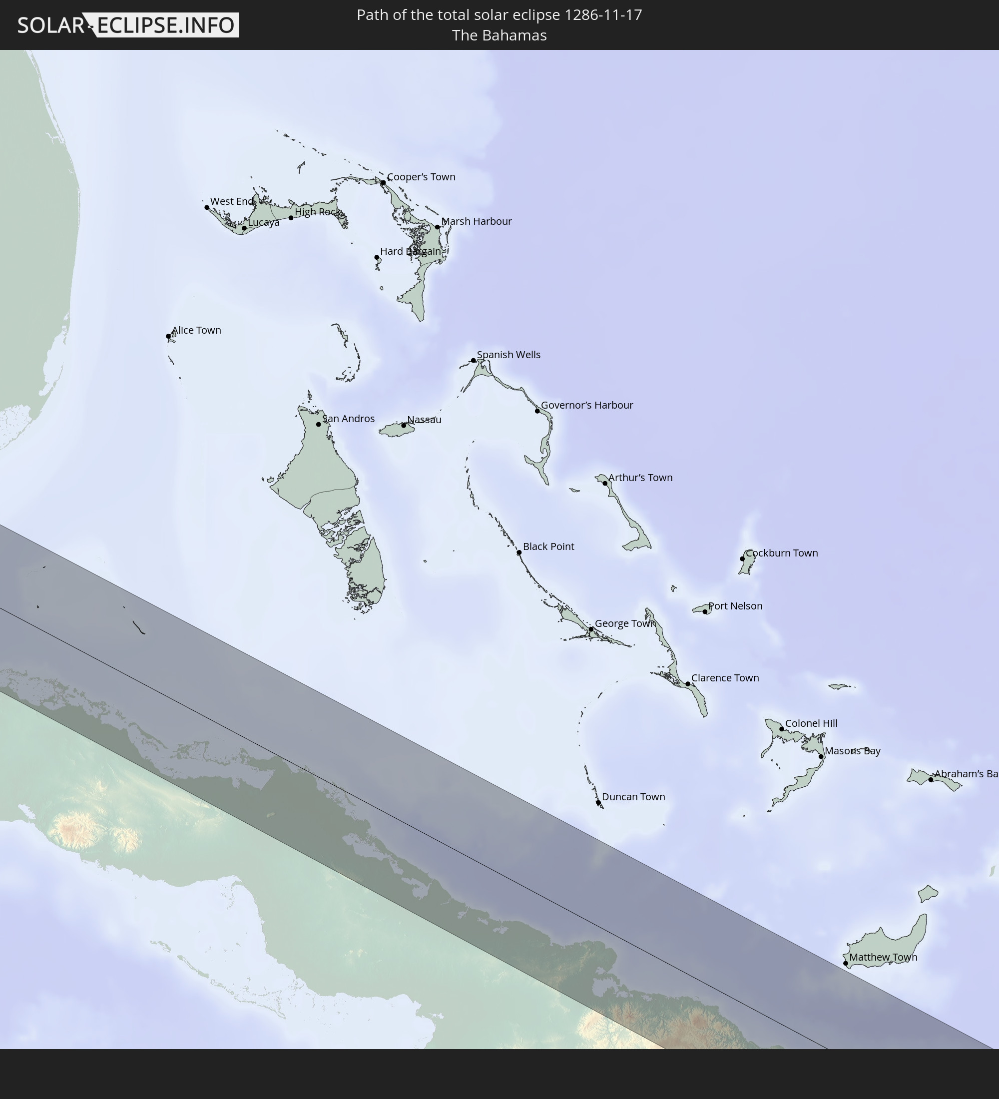 Bahamas
 Haiti
Haiti
 Dominikanische Republik
 St. Vincent und die Grenadinen
 Martinique
 St. Lucia
 Barbados
 Senegal
 Mauretanien
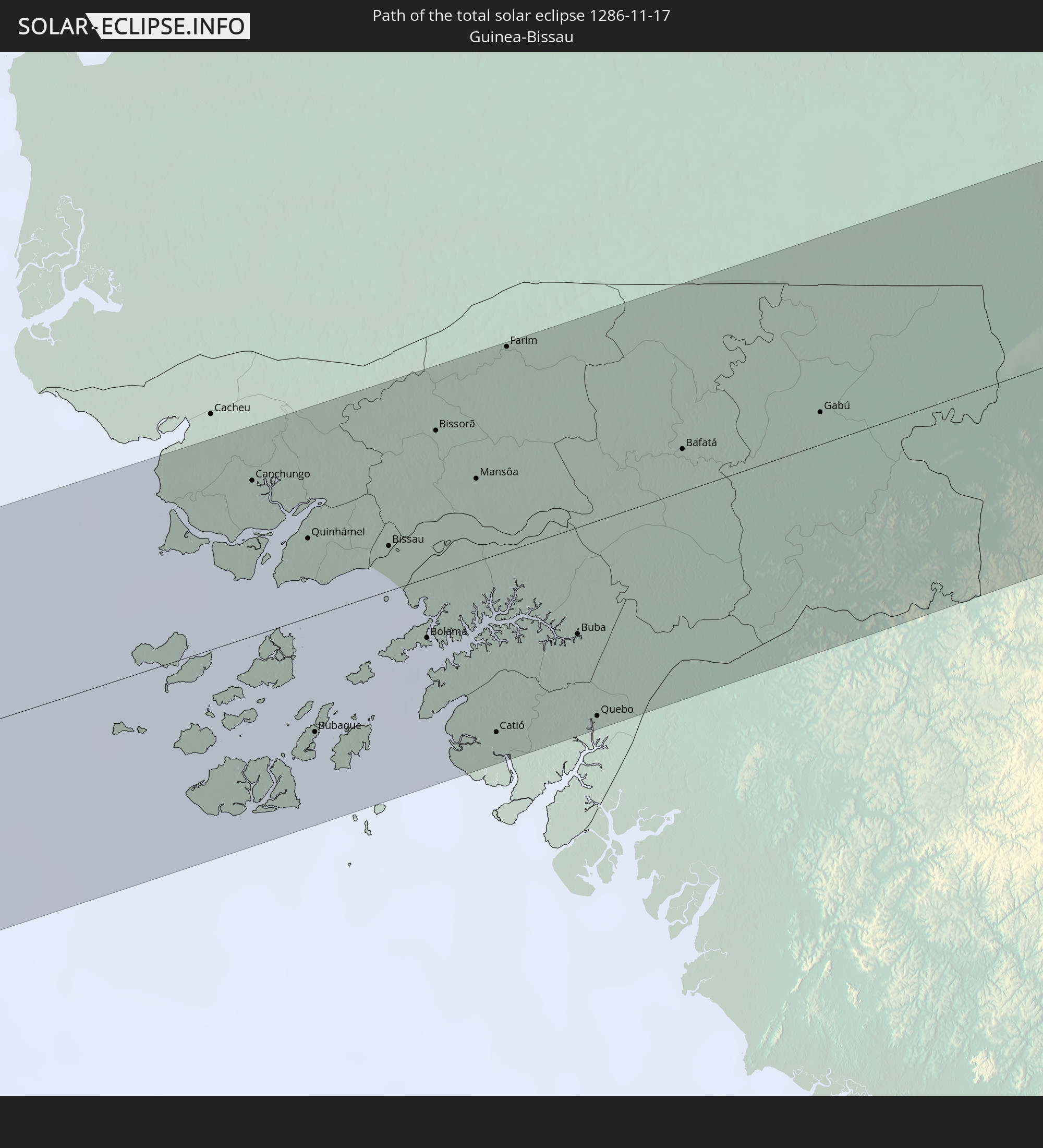 Guinea-Bissau
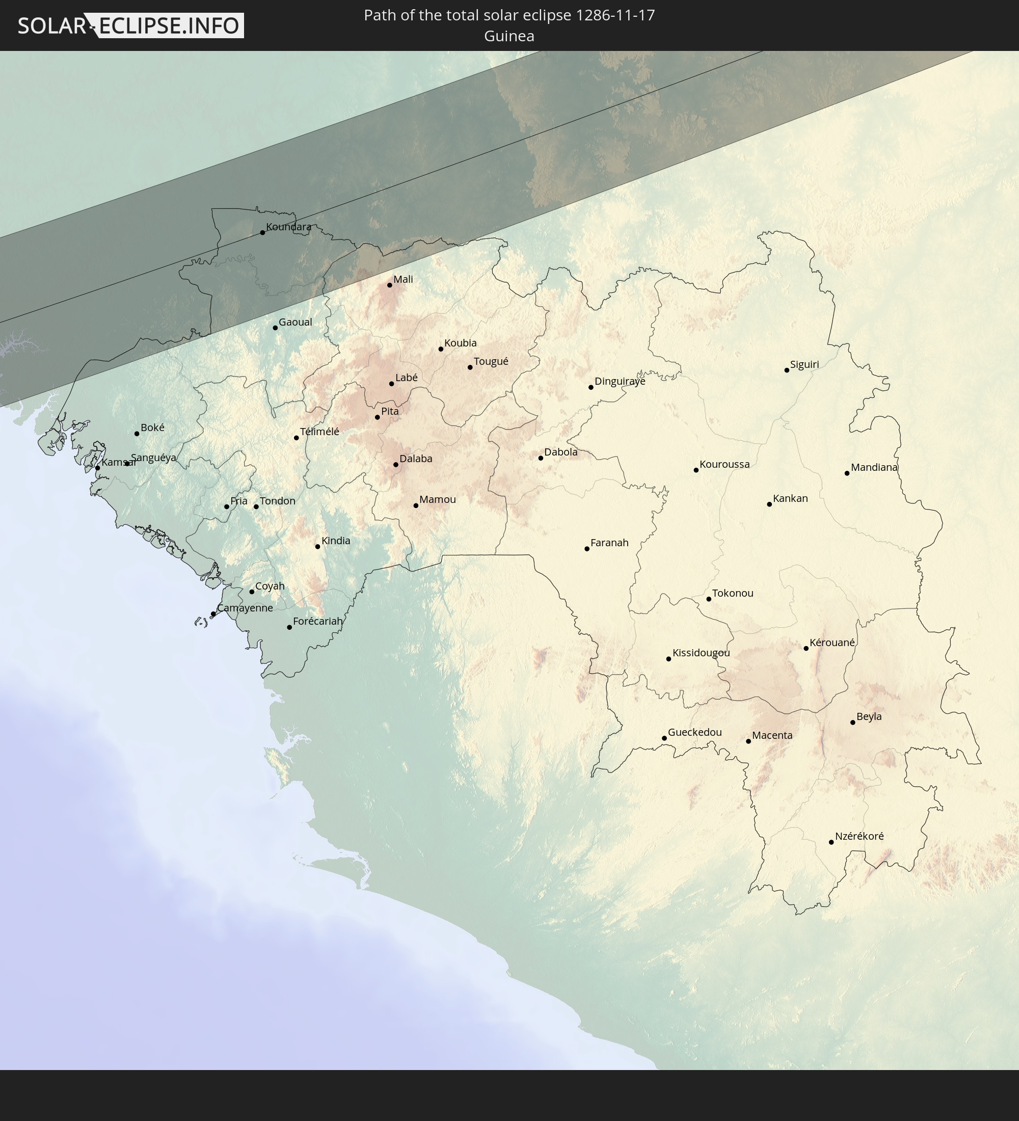 Guinea
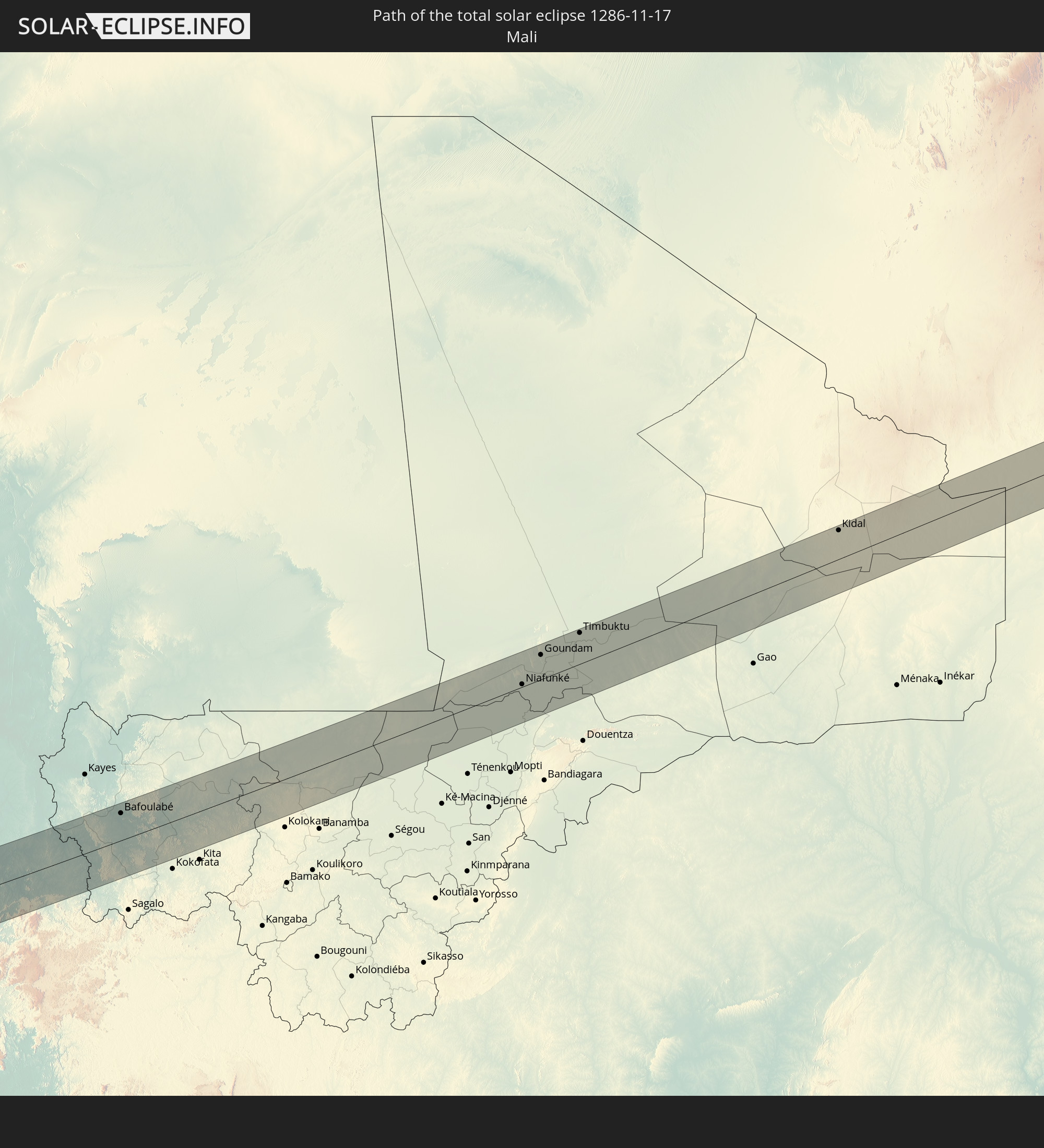 Mali
Mali
 Algerien
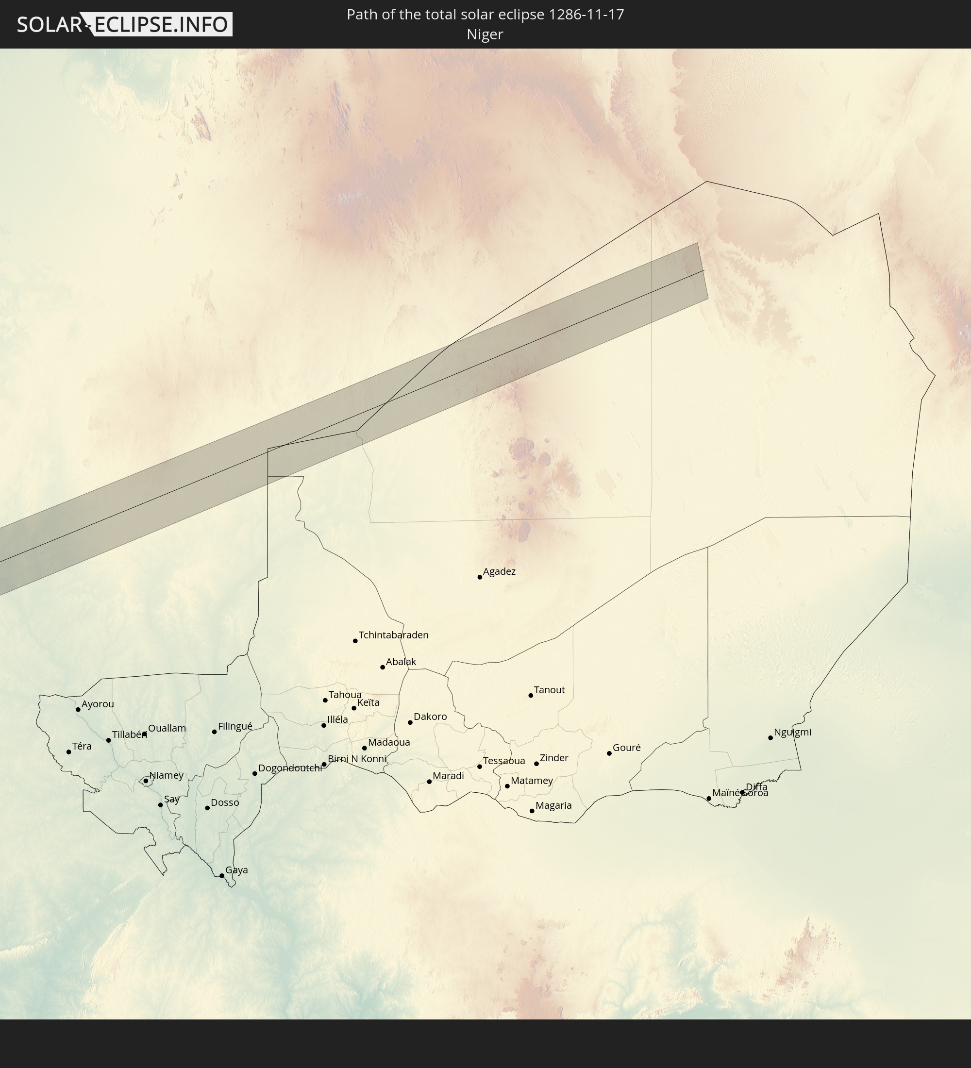 Niger
Niger
In den folgenden Ländern ist die Sonnenfinsternis partiell zu sehen
 Vereinigte Staaten
 United States Minor Outlying Islands
 Kanada
 Mexiko
 Grönland
 Guatemala
 Ecuador
 El Salvador
 Honduras
 Belize
 Nicaragua
 Costa Rica
 Kuba
Kuba
 Panama
 Kolumbien
 Kaimaninseln
 Peru
Peru
 Bahamas
 Jamaika
 Haiti
Haiti
 Brasilien
 Venezuela
 Turks- und Caicosinseln
 Dominikanische Republik
 Aruba
Aruba
 Bolivien
 Puerto Rico
 Amerikanische Jungferninseln
 Bermuda
 Britische Jungferninseln
 Anguilla
 Saint-Martin
 Saint-Barthélemy
 St. Kitts und Nevis
 Paraguay
 Antigua und Barbuda
 Montserrat
 Trinidad und Tobago
 Guadeloupe
 Grenada
 Dominica
 St. Vincent und die Grenadinen
 Guyana
 Martinique
 St. Lucia
 Barbados
 Suriname
 Saint-Pierre und Miquelon
 Französisch-Guayana
 Portugal
 Kap Verde
 Island
 Spanien
 Senegal
 Mauretanien
 Gambia
 Guinea-Bissau
 Guinea
 St. Helena
 Sierra Leone
 Marokko
 Mali
Mali
 Liberia
 Irland
 Algerien
 Vereinigtes Königreich
 Elfenbeinküste
 Burkina Faso
 Gibraltar
 Frankreich
 Isle of Man
 Ghana
Ghana
 Guernsey
 Jersey
 Togo
Togo
 Niger
Niger
 Benin
Benin
 Andorra
 Nigeria
 Äquatorialguinea
 São Tomé und Príncipe
 Tunesien
 Kamerun
 Gabun
Gabun
 Libyen
 Republik Kongo
 Angola
 Demokratische Republik Kongo
 Tschad
 Zentralafrikanische Republik
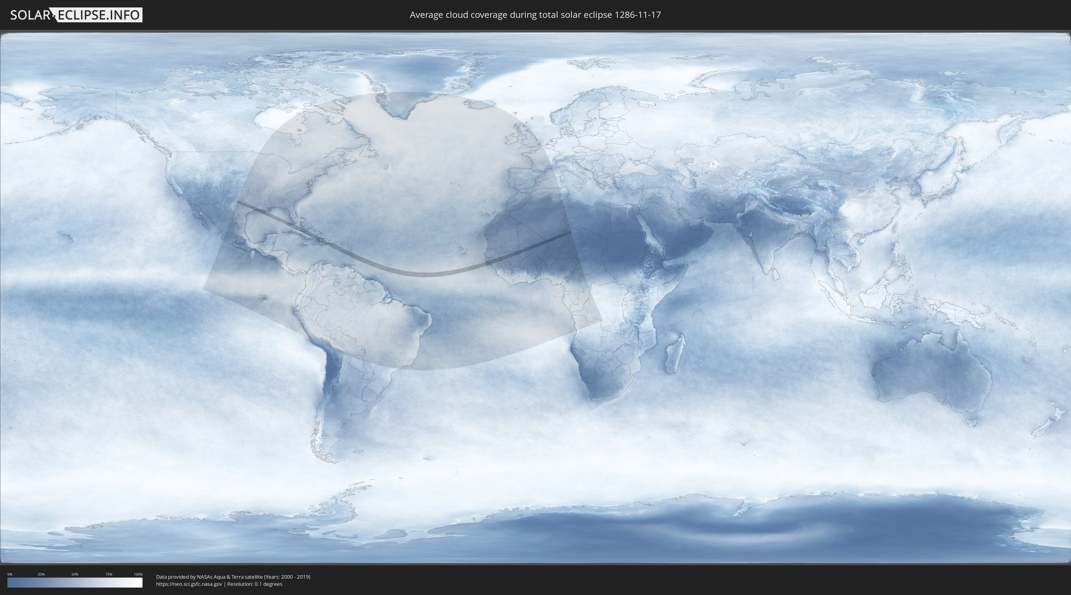
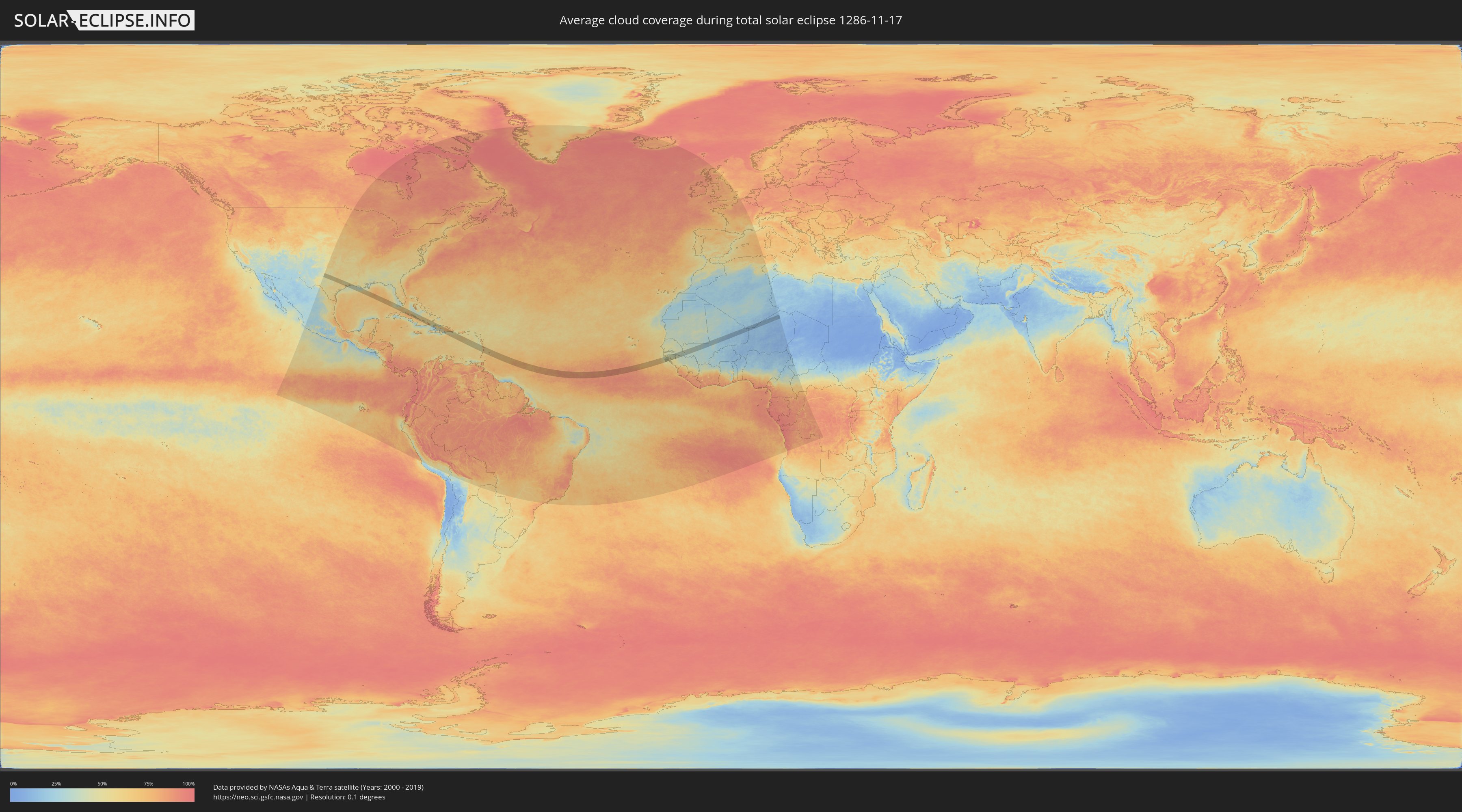
Wie wird das Wetter während der totalen Sonnenfinsternis am 17.11.1286?
Wo ist der beste Ort, um die totale Sonnenfinsternis vom 17.11.1286 zu beobachten?
Die folgenden Karten zeigen die durchschnittliche Bewölkung für den Tag, an dem die totale Sonnenfinsternis
stattfindet. Mit Hilfe der Karten lässt sich der Ort entlang des Finsternispfades eingrenzen,
der die besten Aussichen auf einen klaren wolkenfreien Himmel bietet.
Trotzdem muss man immer lokale Gegenenheiten beachten und sollte sich genau über das Wetter an seinem
gewählten Beobachtungsort informieren.
Die Daten stammen von den beiden NASA-Satelliten
AQUA und TERRA
und wurden über einen Zeitraum von 19 Jahren (2000 - 2019) gemittelt.
Detaillierte Länderkarten
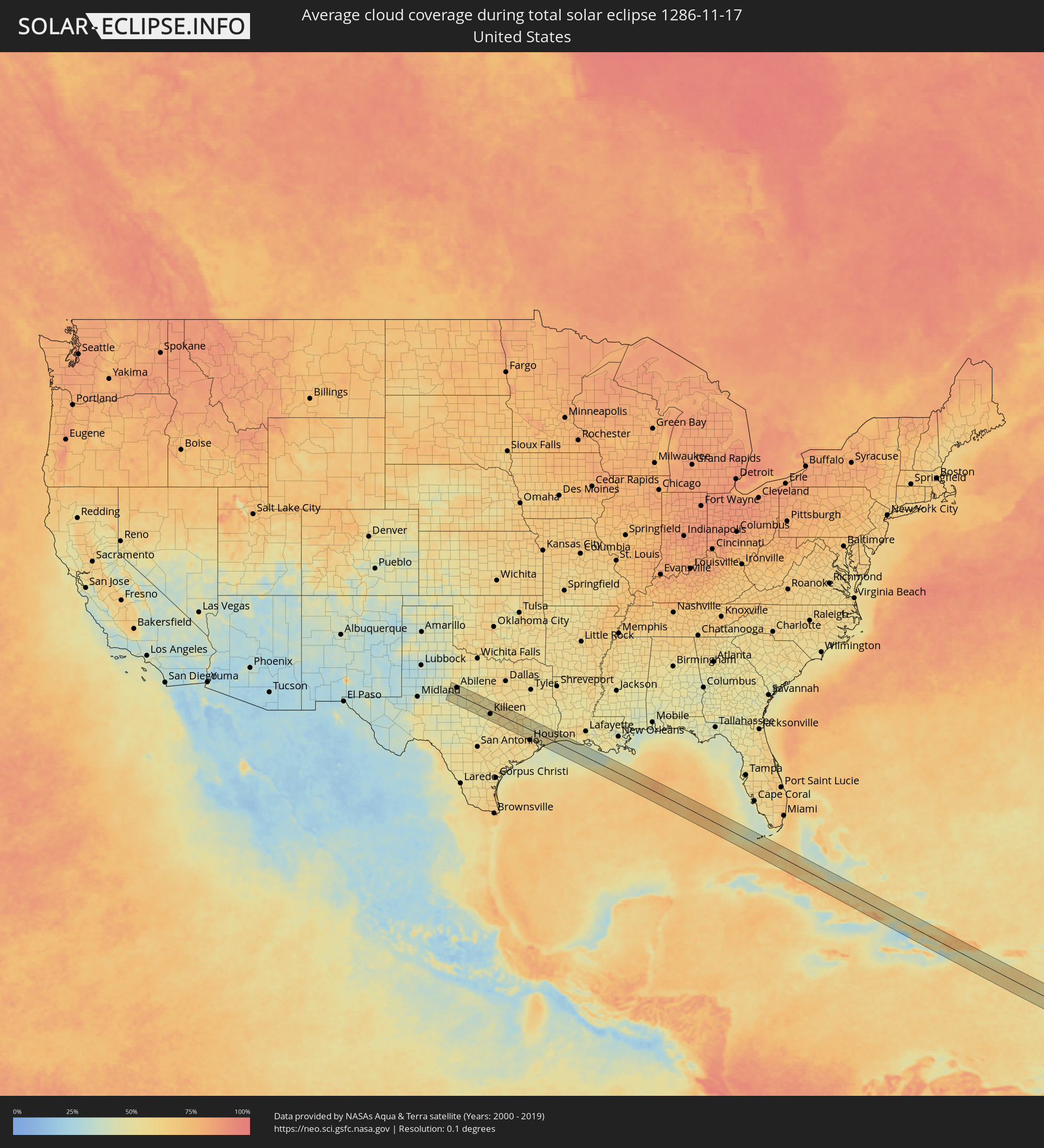 Vereinigte Staaten
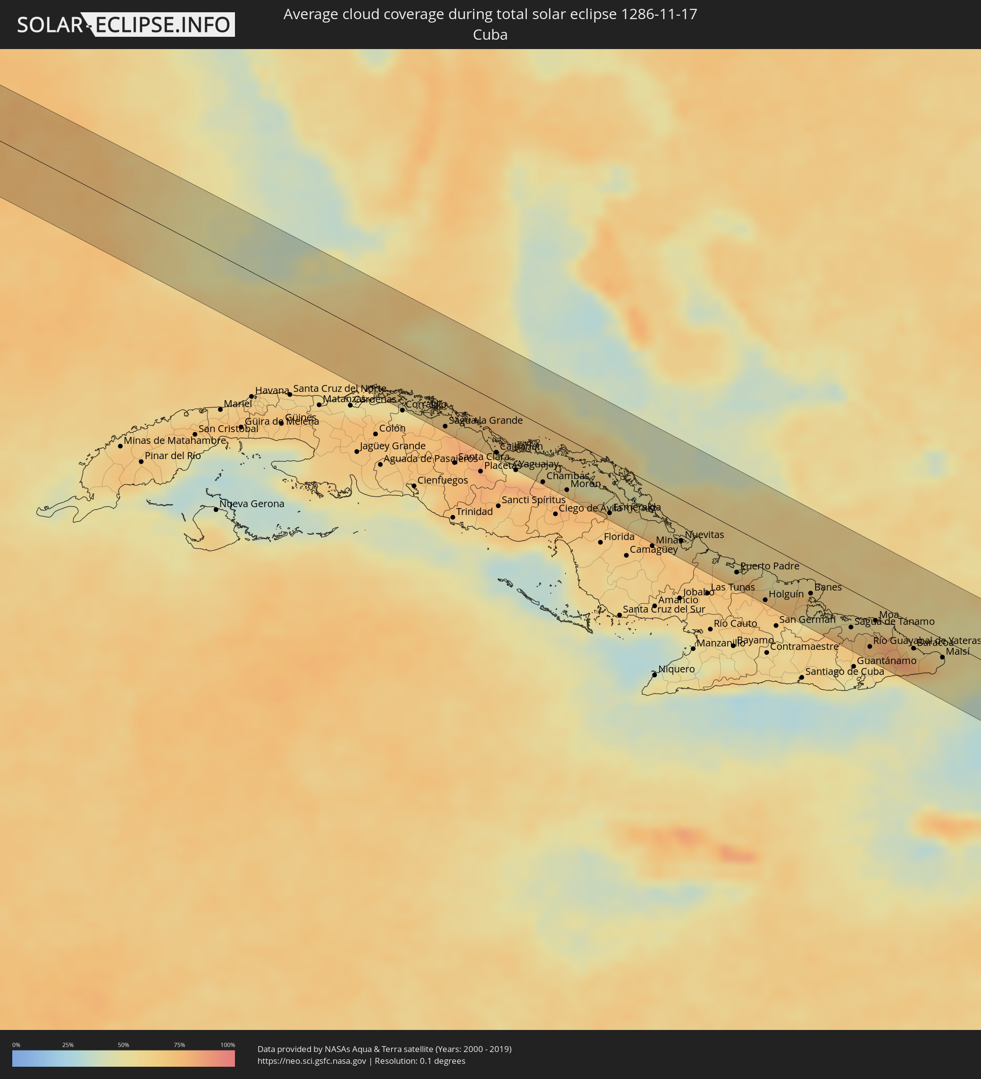 Kuba
Kuba
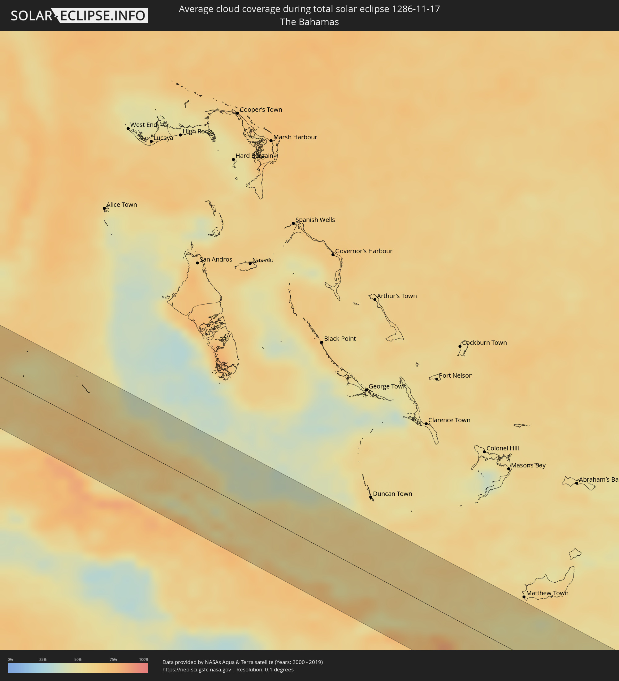 Bahamas
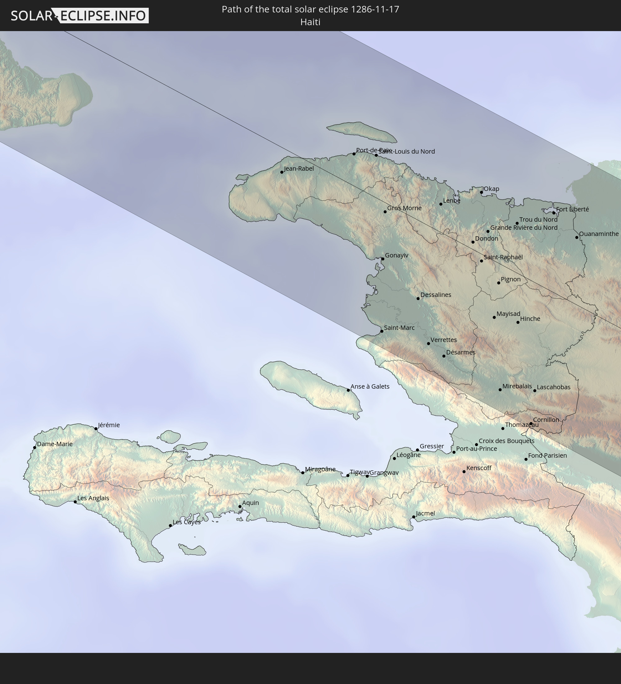
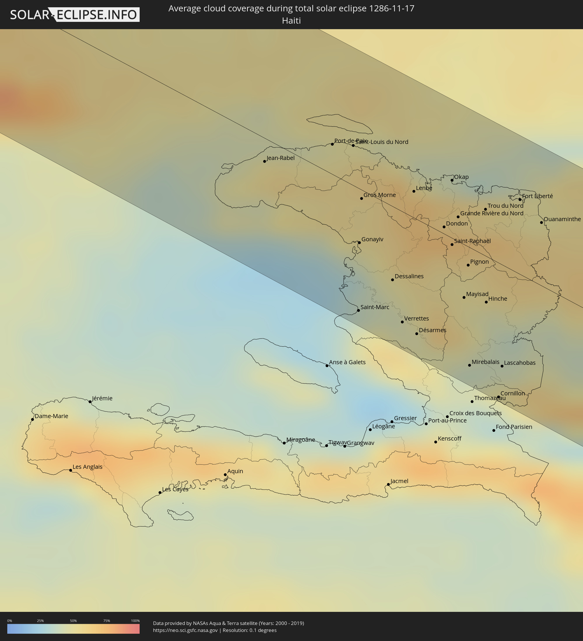 Haiti
Haiti
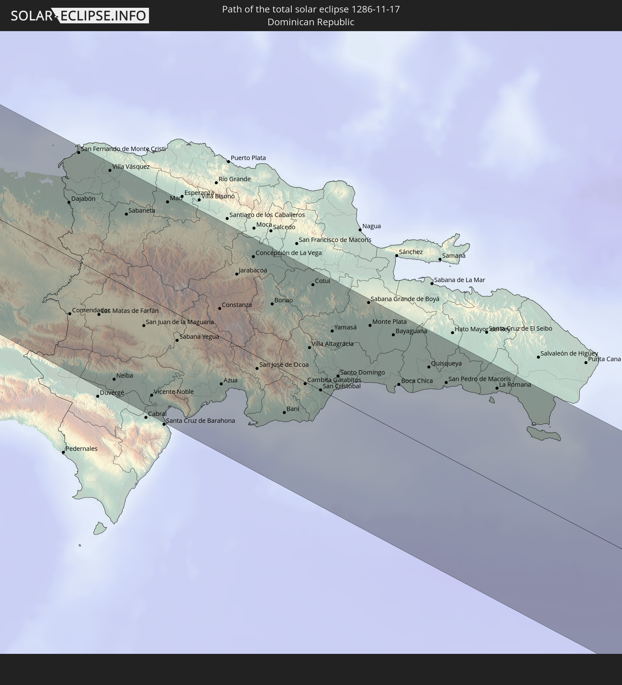
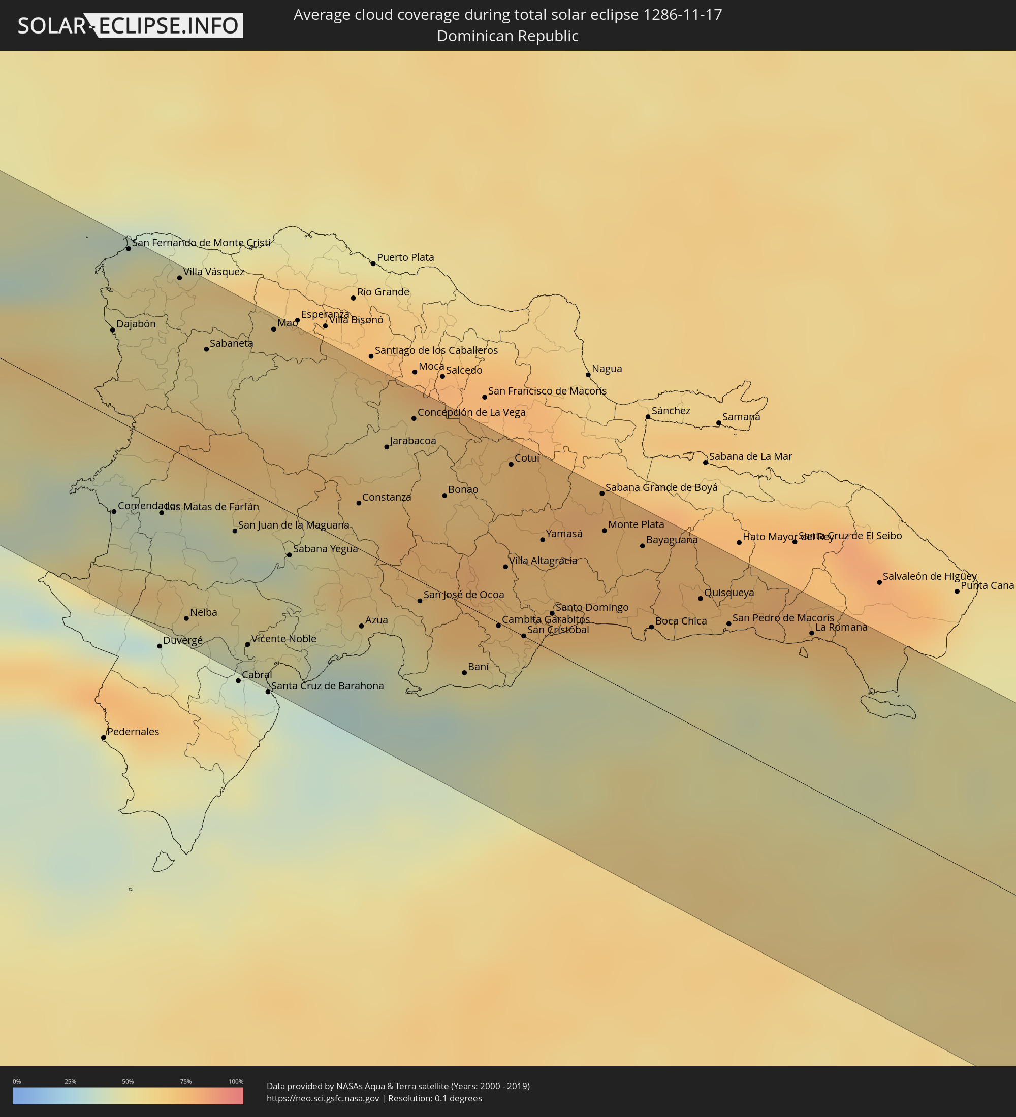 Dominikanische Republik
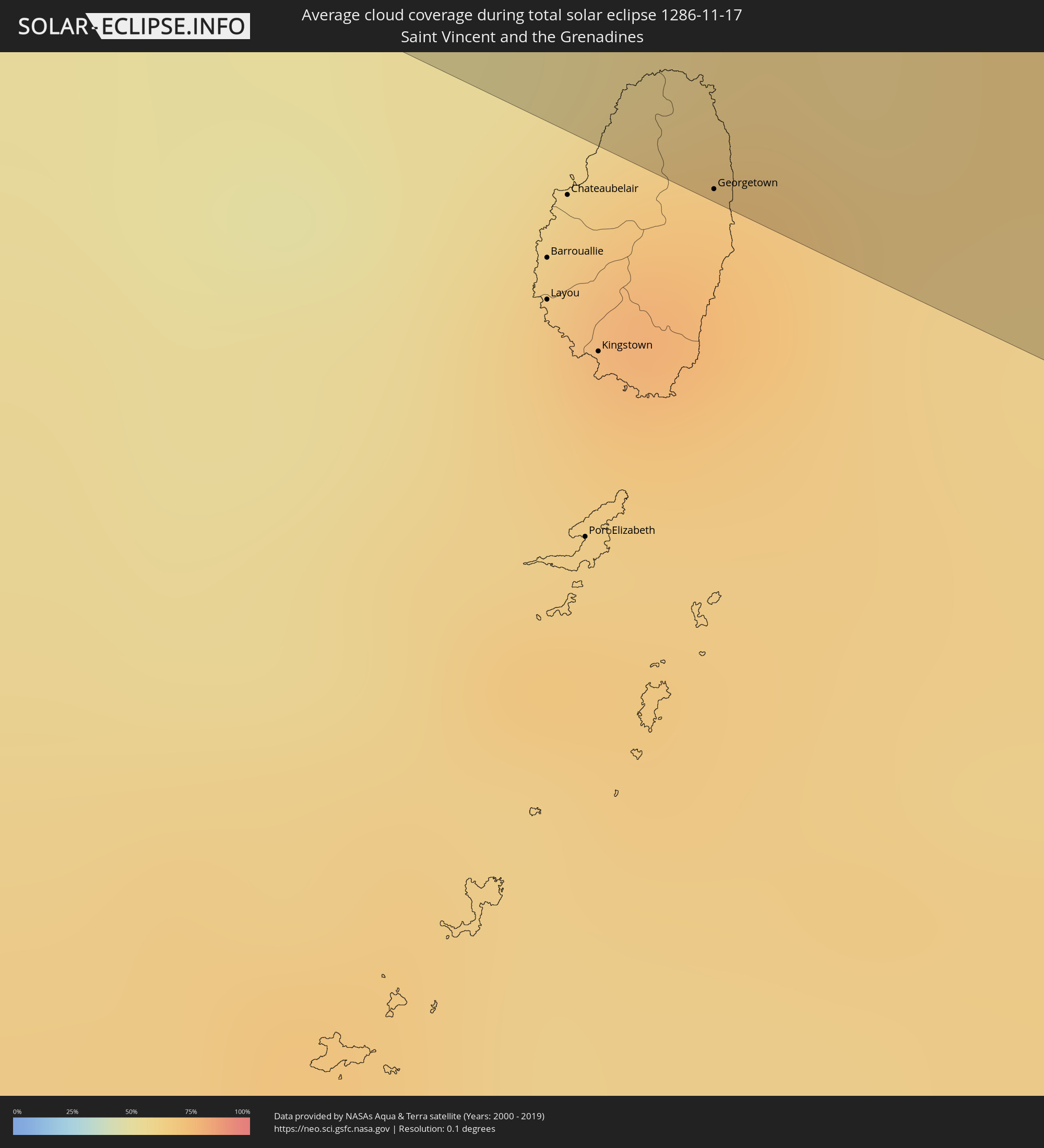 St. Vincent und die Grenadinen
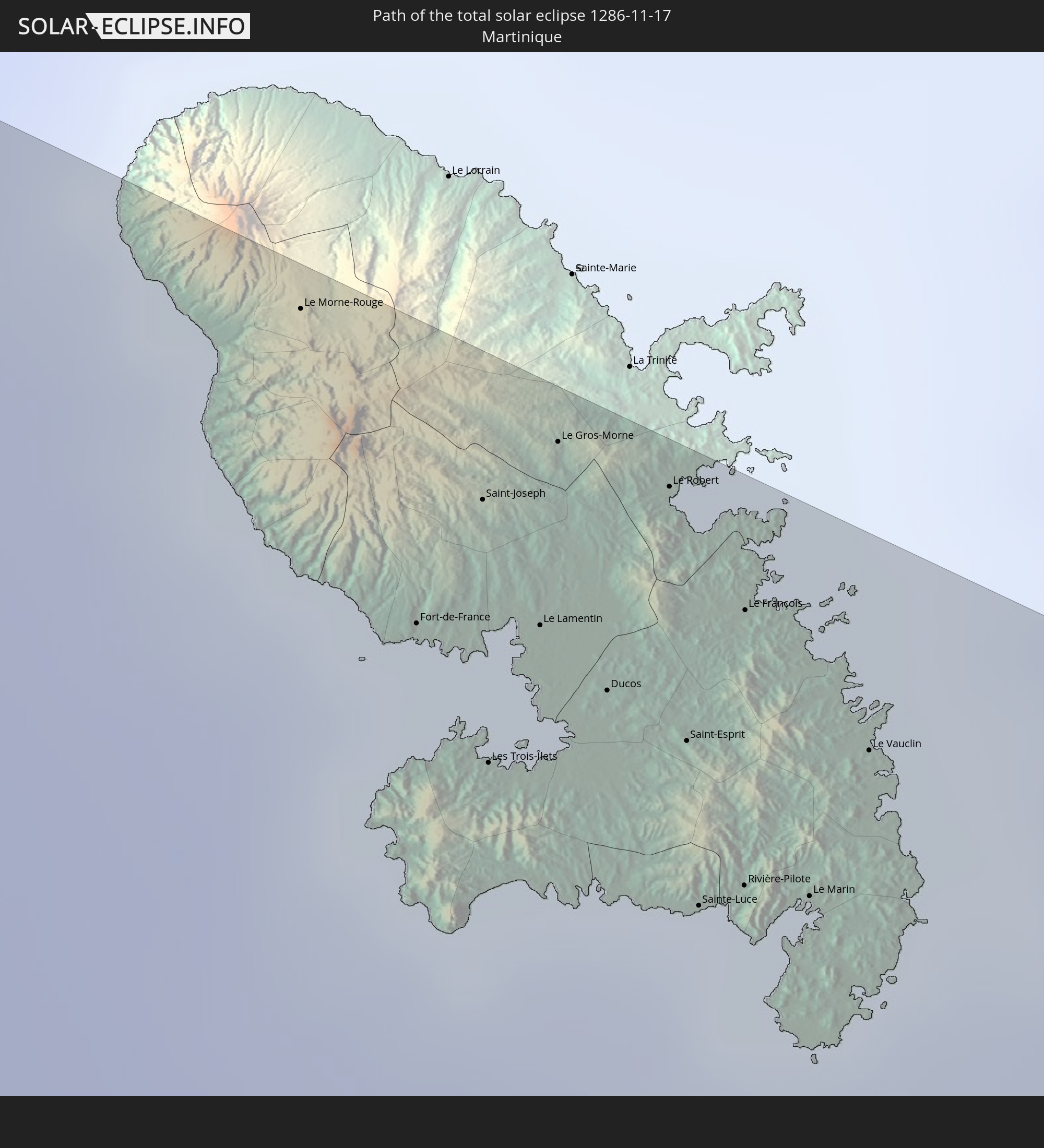
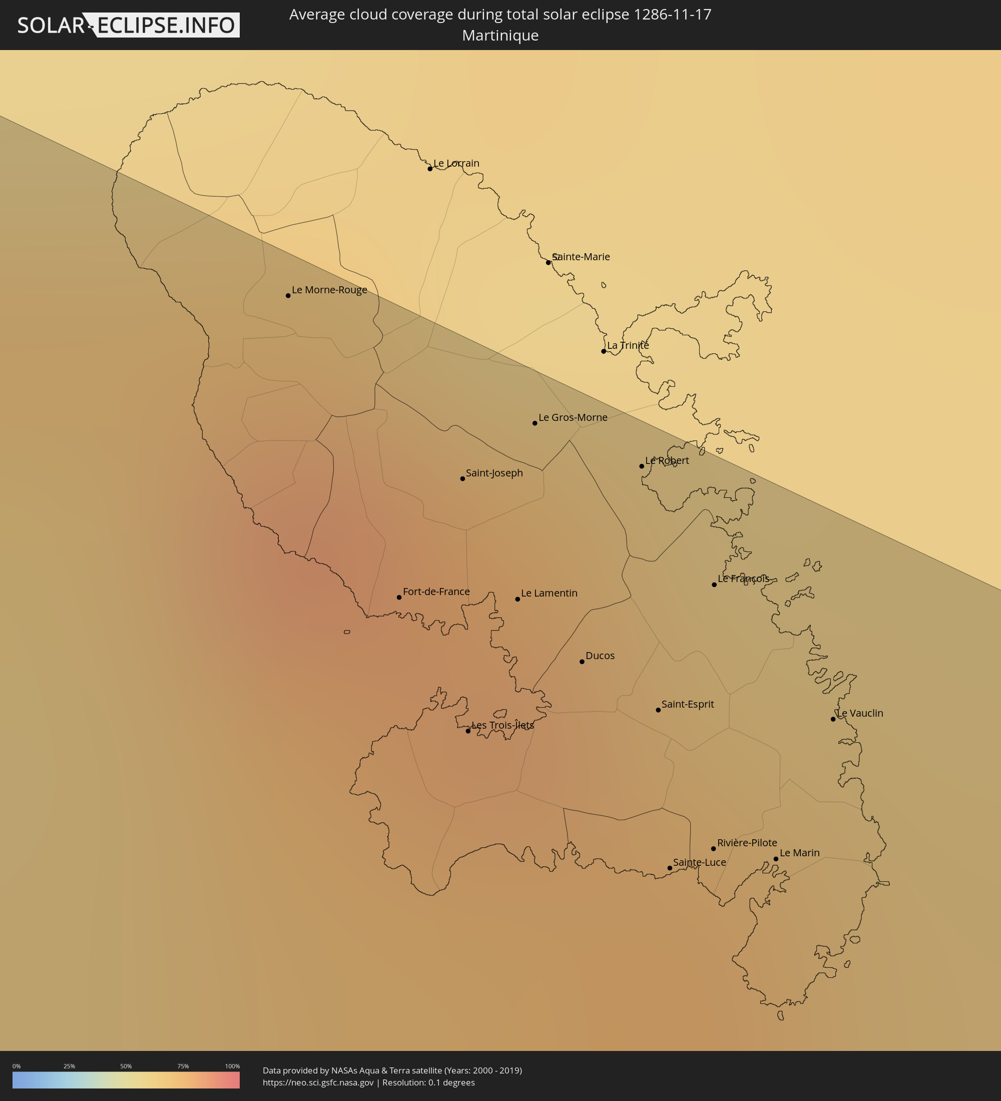 Martinique
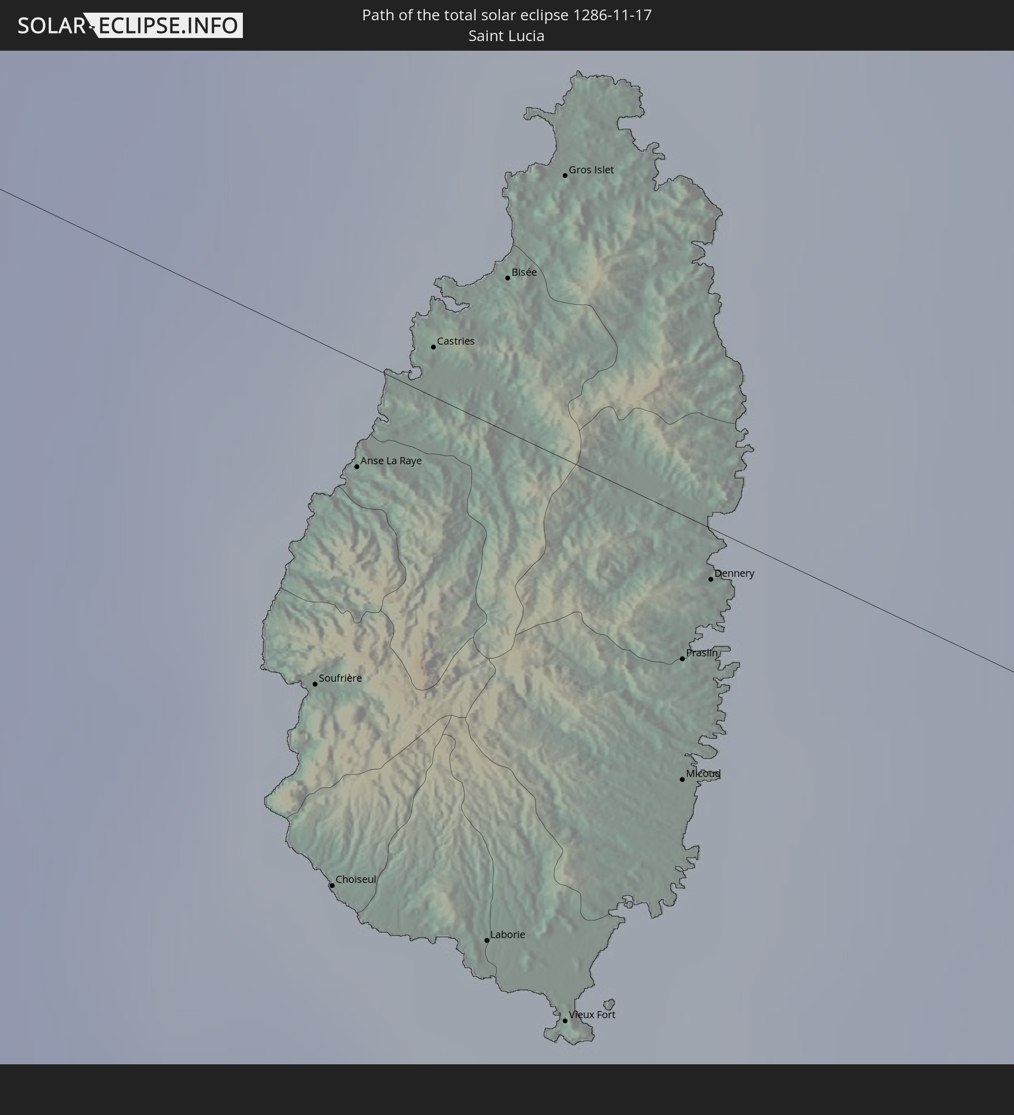
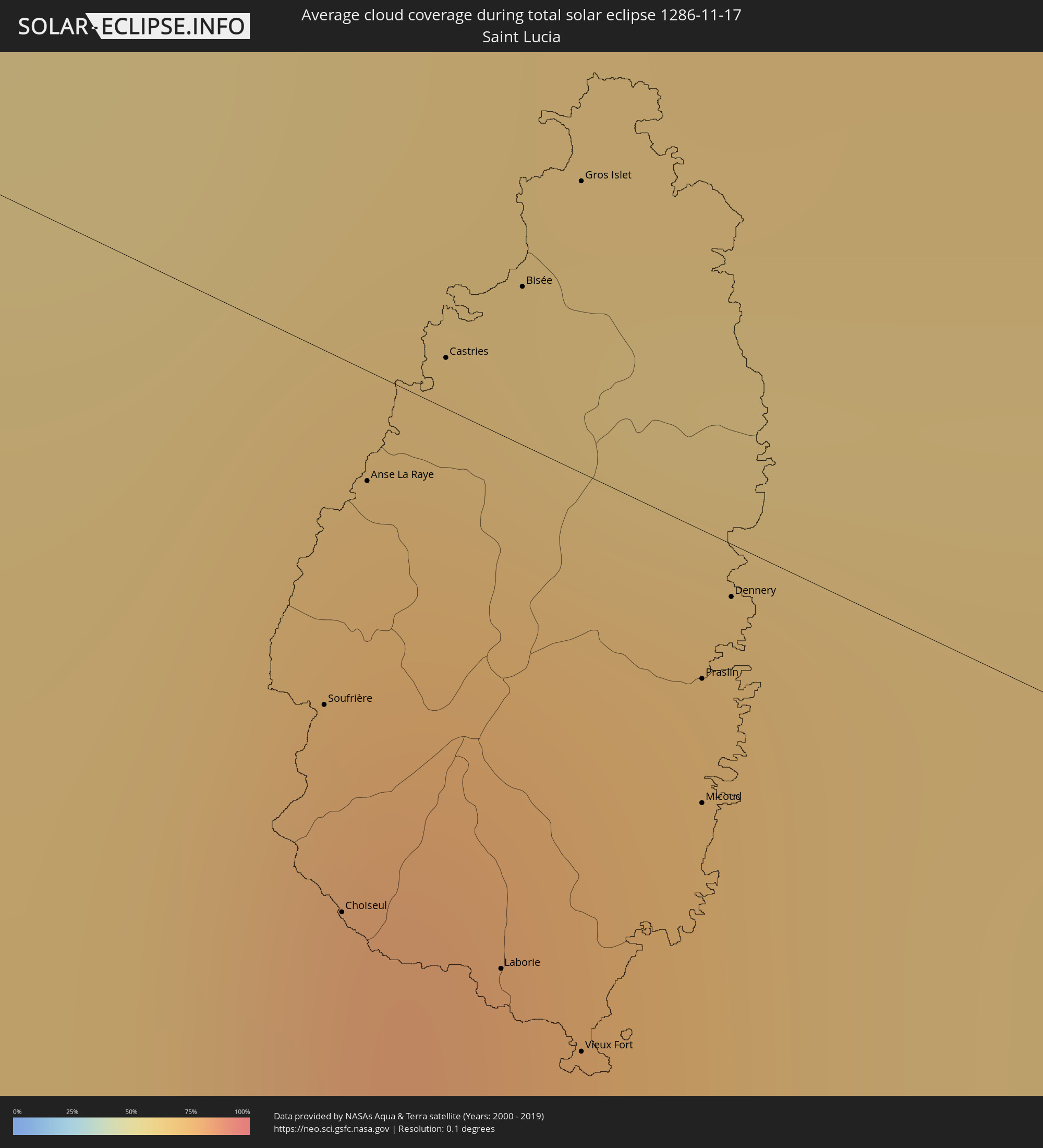 St. Lucia
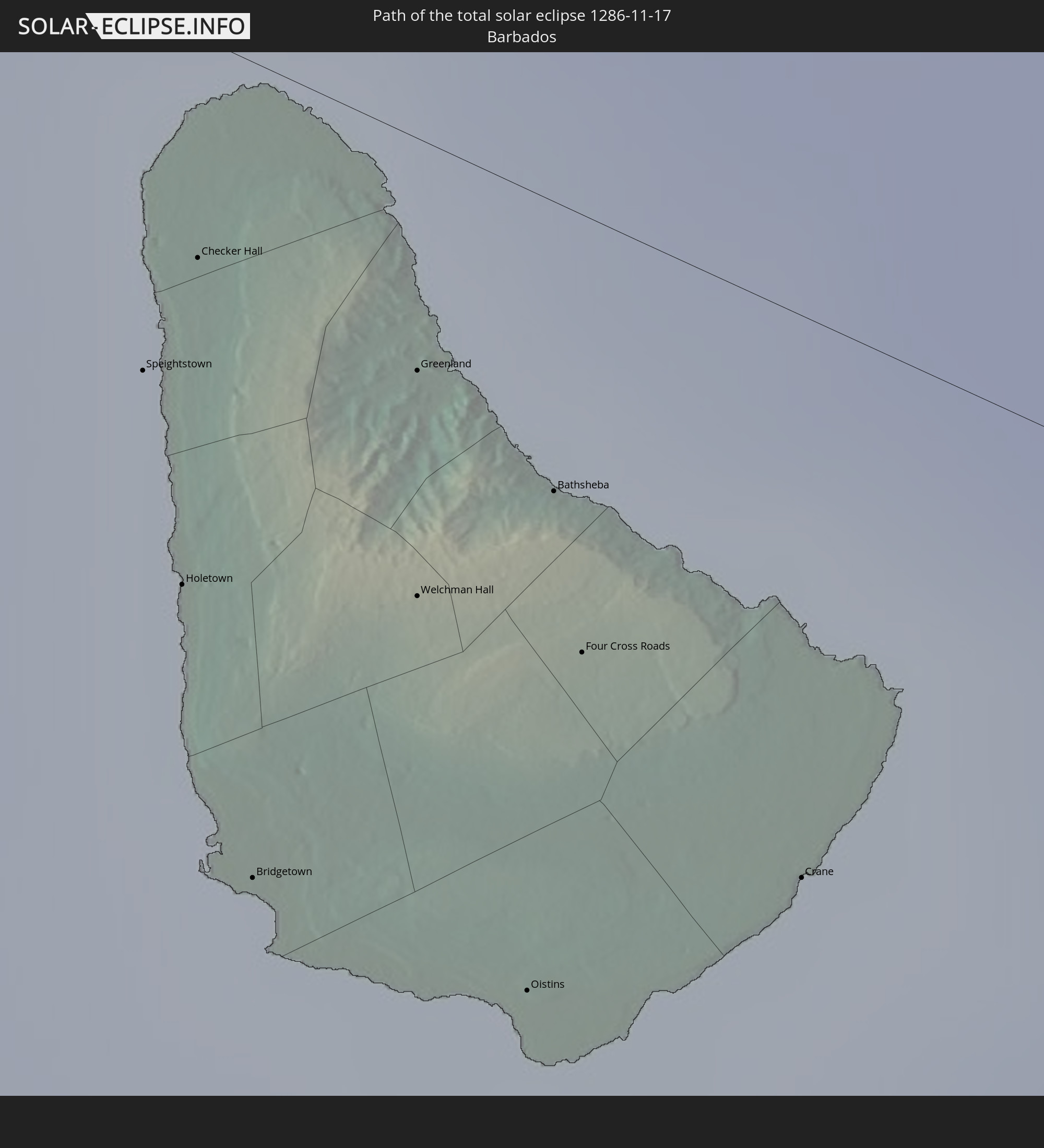
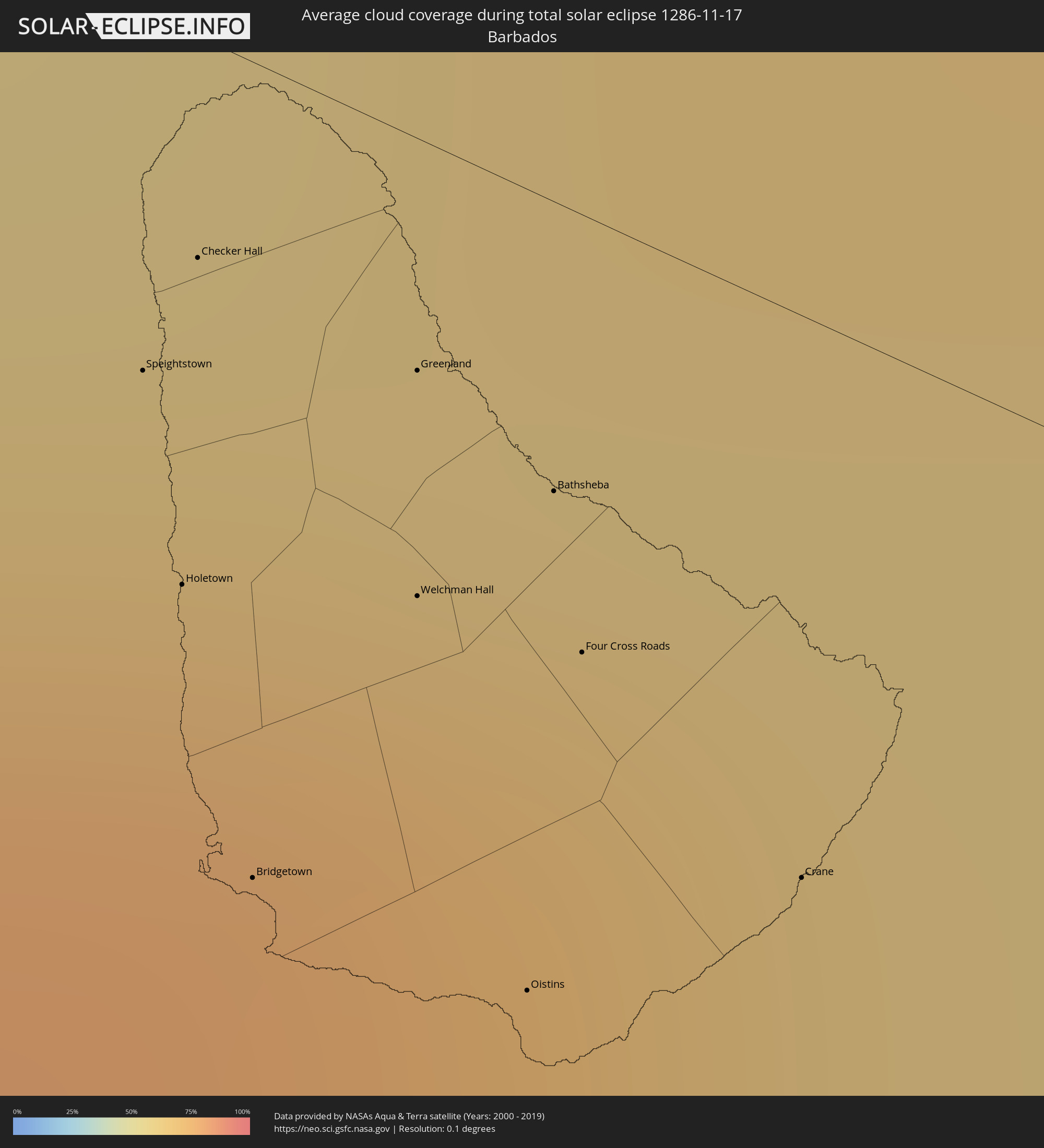 Barbados
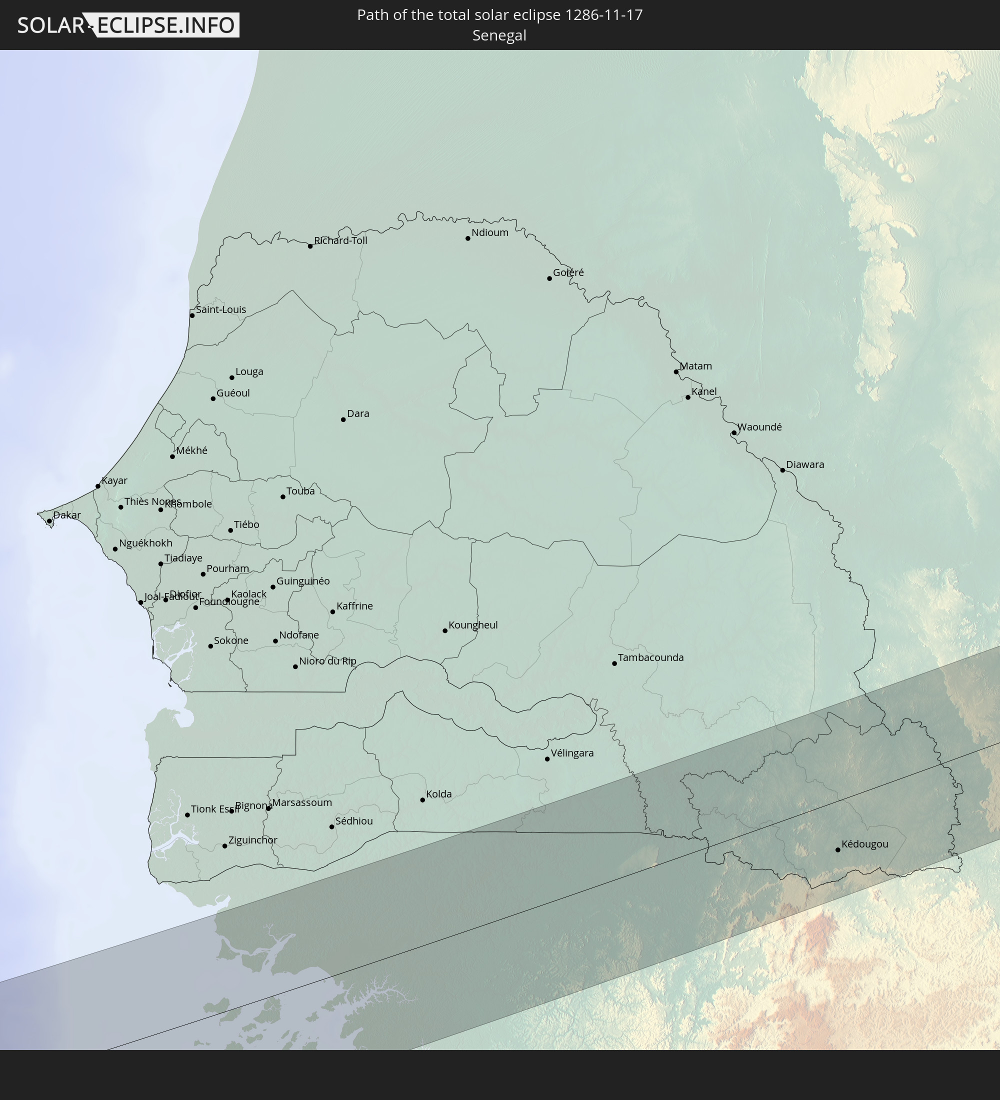
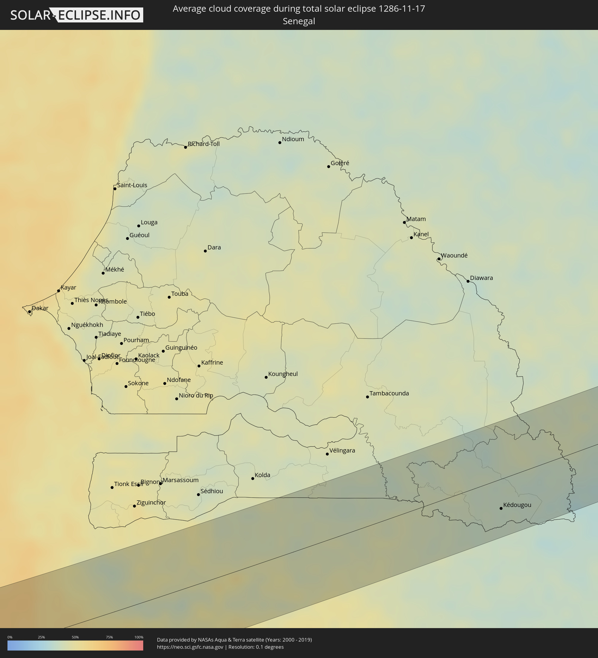 Senegal
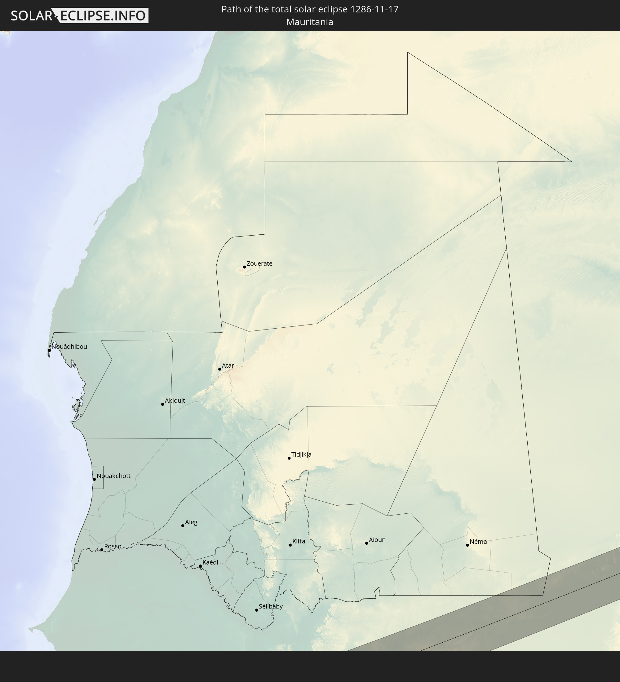
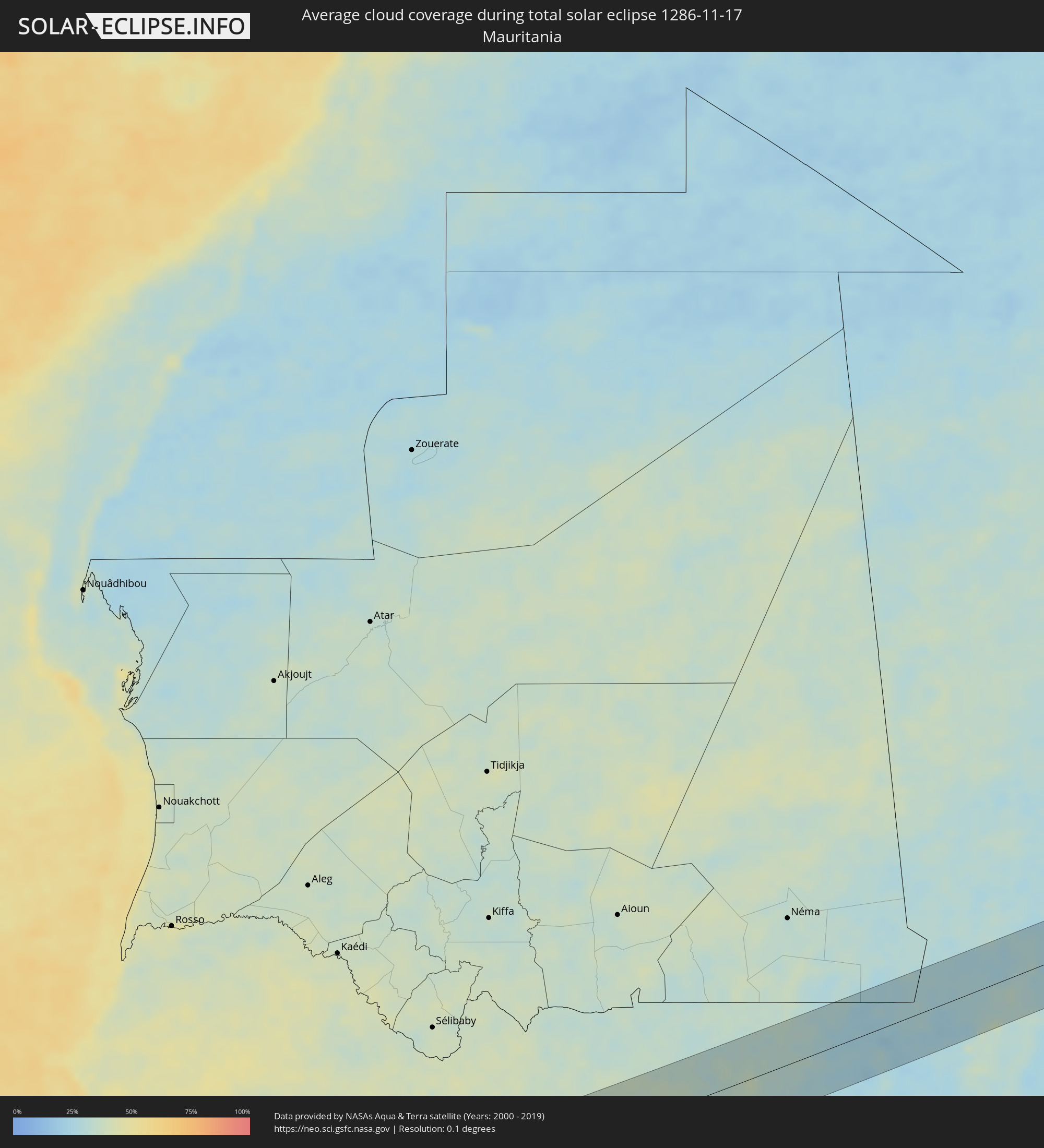 Mauretanien
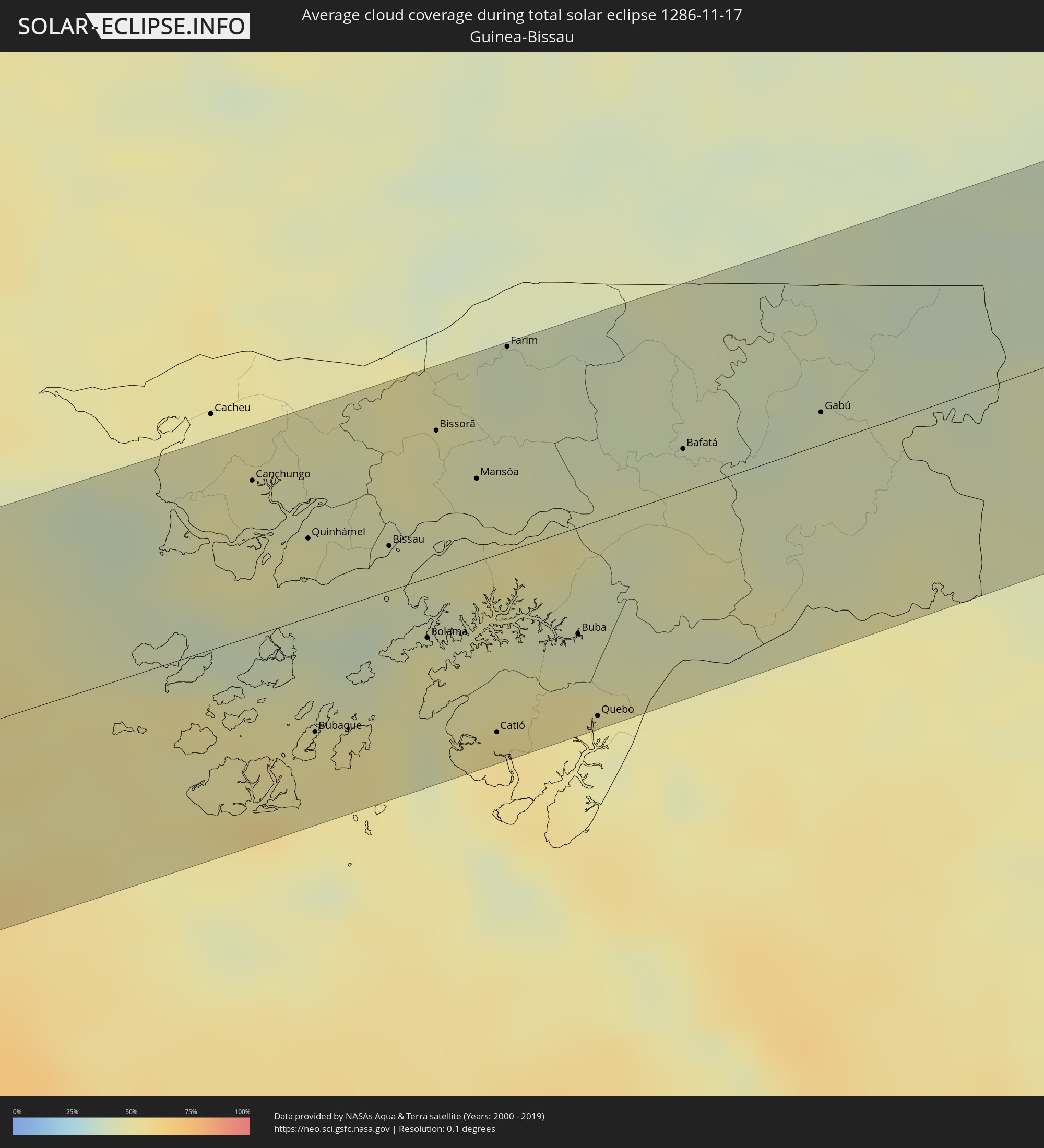 Guinea-Bissau
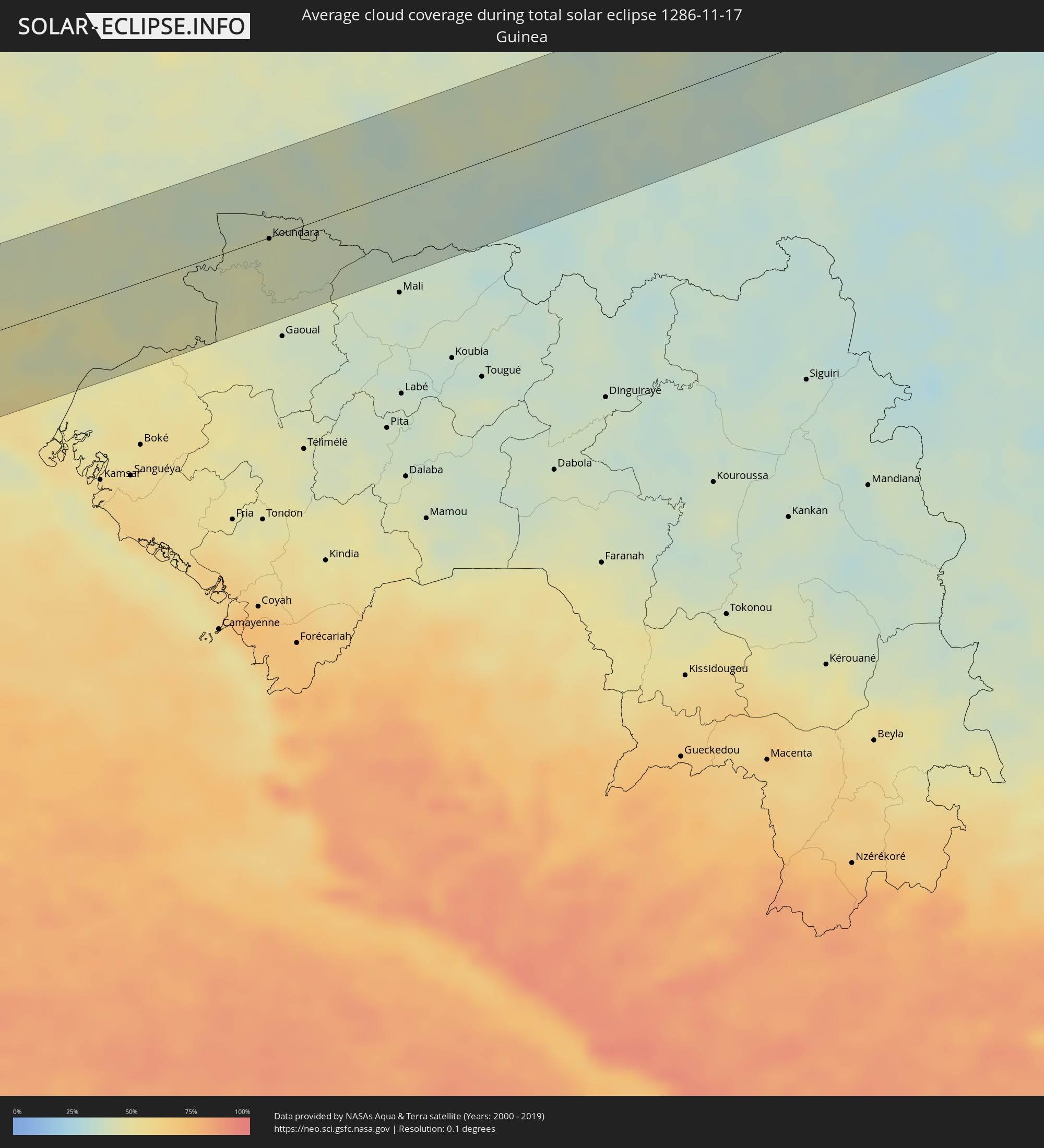 Guinea
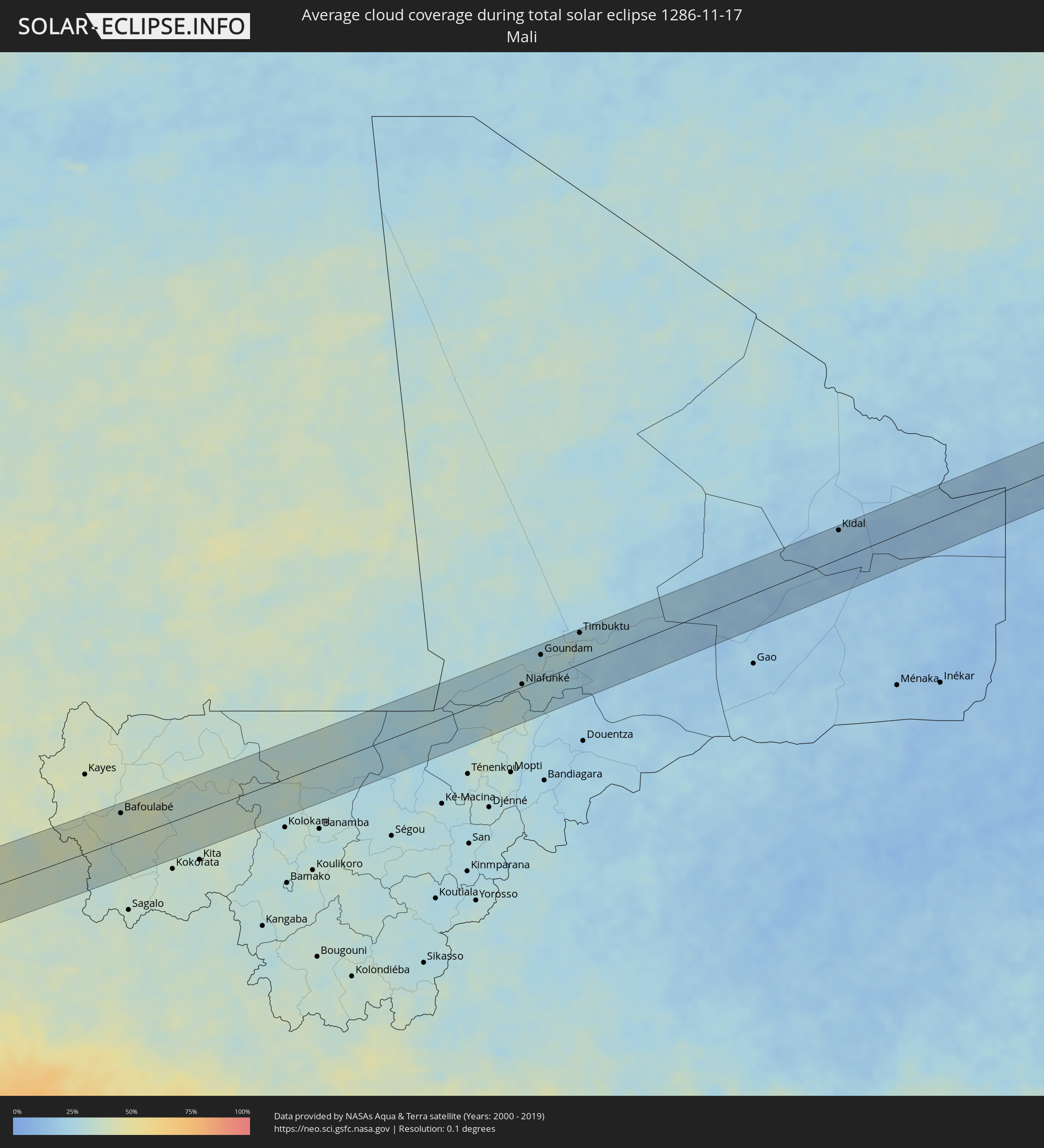 Mali
Mali
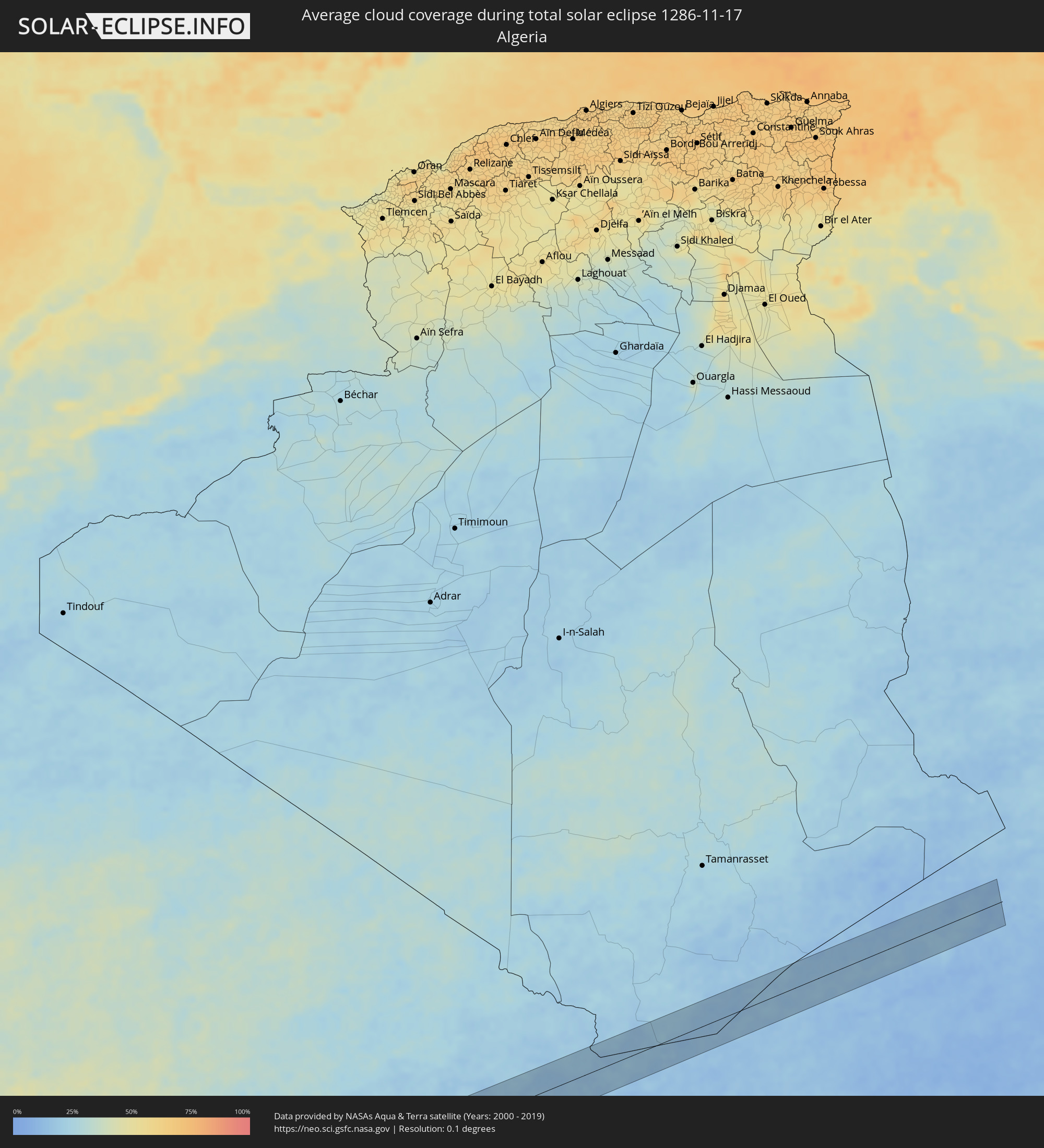 Algerien
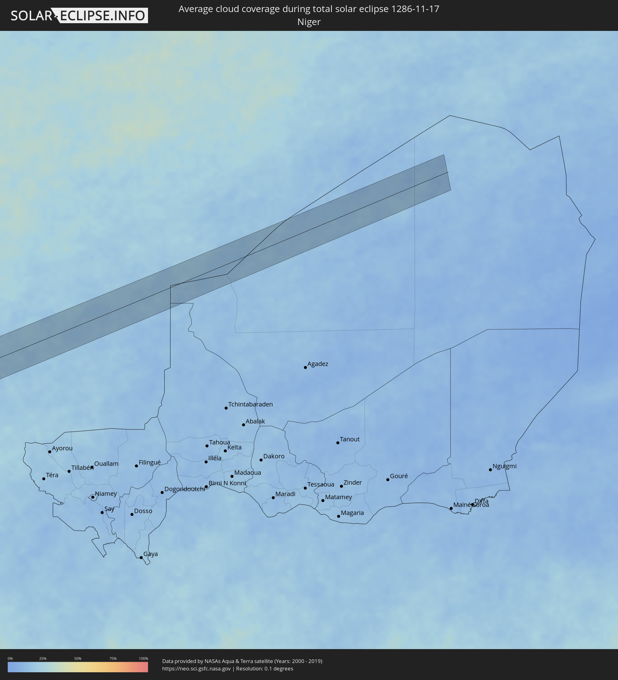 Niger
Niger
Orte im Finsternispfad
Die nachfolgene Tabelle zeigt Städte und Orte mit mehr als 5.000 Einwohnern, die sich im Finsternispfad befinden. Städte mit mehr als 100.000 Einwohnern sind dick gekennzeichnet. Mit einem Klick auf den Ort öffnet sich eine Detailkarte die die Lage des jeweiligen Ortes zusammen mit dem Verlauf der zentralen Finsternis präsentiert.
| Ort | Typ | Dauer der Verfinsterung | Ortszeit bei maximaler Verfinsterung | Entfernung zur Zentrallinie | Ø Bewölkung |
|
Abilene, Texas
|
total | - | 07:24:59 UTC-06:00 | 37 km | 52% |
|
Brownwood, Texas
|
total | - | 07:24:43 UTC-06:00 | 10 km | 52% |
|
Copperas Cove, Texas
|
total | - | 07:24:42 UTC-06:00 | 24 km | 53% |
|
Killeen, Texas
|
total | - | 07:24:45 UTC-06:00 | 18 km | 56% |
|
Temple, Texas
|
total | - | 07:24:52 UTC-06:00 | 4 km | 59% |
|
Waco, Texas
|
total | - | 07:25:12 UTC-06:00 | 49 km | 59% |
|
College Station, Texas
|
total | - | 07:24:57 UTC-06:00 | 10 km | 57% |
|
Cypress, Texas
|
total | - | 07:24:50 UTC-06:00 | 49 km | 65% |
|
Huntsville, Texas
|
total | - | 07:25:18 UTC-06:00 | 32 km | 52% |
|
The Woodlands, Texas
|
total | - | 07:25:01 UTC-06:00 | 22 km | 56% |
|
Conroe, Texas
|
total | - | 07:25:07 UTC-06:00 | 5 km | 51% |
|
Atascocita, Texas
|
total | - | 07:25:03 UTC-06:00 | 24 km | 57% |
|
Cloverleaf, Texas
|
total | - | 07:24:56 UTC-06:00 | 46 km | 64% |
|
Baytown, Texas
|
total | - | 07:25:00 UTC-06:00 | 42 km | 57% |
|
Beaumont, Texas
|
total | - | 07:25:33 UTC-06:00 | 30 km | 59% |
|
Port Arthur, Texas
|
total | - | 07:25:31 UTC-06:00 | 16 km | 52% |
|
Key West, Florida
|
total | - | 08:31:37 UTC-05:00 | 35 km | 46% |
|
Sagua la Grande, Villa Clara
|
total | - | 08:03:18 UTC-05:29 | 56 km | 74% |
|
Remedios, Villa Clara
|
total | - | 08:03:48 UTC-05:29 | 62 km | 73% |
|
Caibarién, Villa Clara
|
total | - | 08:03:53 UTC-05:29 | 55 km | 73% |
|
Chambas, Ciego de Ávila
|
total | - | 08:04:26 UTC-05:29 | 61 km | 77% |
|
Morón, Ciego de Ávila
|
total | - | 08:04:44 UTC-05:29 | 56 km | 77% |
|
Esmeralda, Camagüey
|
total | - | 08:05:16 UTC-05:29 | 56 km | 73% |
|
Nuevitas, Camagüey
|
total | - | 08:06:13 UTC-05:29 | 45 km | 60% |
|
Puerto Padre, Las Tunas
|
total | - | 08:06:59 UTC-05:29 | 47 km | 66% |
|
Jesús Menéndez, Las Tunas
|
total | - | 08:07:07 UTC-05:29 | 44 km | 67% |
|
Holguín, Holguín
|
total | - | 08:07:22 UTC-05:29 | 61 km | 68% |
|
Gibara, Holguín
|
total | - | 08:07:33 UTC-05:29 | 32 km | 61% |
|
Banes, Holguín
|
total | - | 08:08:03 UTC-05:29 | 27 km | 64% |
|
Sagua de Tánamo, Holguín
|
total | - | 08:08:39 UTC-05:29 | 41 km | 67% |
|
Río Guayabal de Yateras, Guantánamo
|
total | - | 08:08:55 UTC-05:29 | 51 km | 68% |
|
Moa, Holguín
|
total | - | 08:09:02 UTC-05:29 | 19 km | 57% |
|
Baracoa, Guantánamo
|
total | - | 08:09:37 UTC-05:29 | 27 km | 81% |
|
Maisí, Guantánamo
|
total | - | 08:10:05 UTC-05:29 | 20 km | 67% |
|
Port-de-Paix, Nord-Ouest
|
total | - | 08:52:31 UTC-04:49 | 15 km | 53% |
|
Saint-Louis du Nord, Nord-Ouest
|
total | - | 08:52:41 UTC-04:49 | 19 km | 56% |
|
Saint-Marc, Artibonite
|
total | - | 08:52:43 UTC-04:49 | 60 km | 44% |
|
Gonayiv, Artibonite
|
total | - | 08:52:43 UTC-04:49 | 27 km | 34% |
|
Dessalines, Artibonite
|
total | - | 08:52:59 UTC-04:49 | 36 km | 47% |
|
Verrettes, Artibonite
|
total | - | 08:53:04 UTC-04:49 | 54 km | 45% |
|
Lenbe, Nord
|
total | - | 08:53:09 UTC-04:49 | 13 km | 67% |
|
Désarmes, Artibonite
|
total | - | 08:53:11 UTC-04:49 | 56 km | 47% |
|
Okap, Nord
|
total | - | 08:53:27 UTC-04:49 | 28 km | 41% |
|
Saint-Raphaël, Nord
|
total | - | 08:53:27 UTC-04:49 | 3 km | 51% |
|
Grande Rivière du Nord, Nord
|
total | - | 08:53:30 UTC-04:49 | 12 km | 68% |
|
Mirebalais, Centre
|
total | - | 08:53:36 UTC-04:49 | 58 km | 43% |
|
Trou du Nord, Nord-Est
|
total | - | 08:53:43 UTC-04:49 | 23 km | 66% |
|
Hinche, Centre
|
total | - | 08:53:43 UTC-04:49 | 23 km | 44% |
|
Lascahobas, Centre
|
total | - | 08:53:51 UTC-04:49 | 50 km | 54% |
|
Fort Liberté, Nord-Est
|
total | - | 08:53:59 UTC-04:49 | 37 km | 49% |
|
Ouanaminthe, Nord-Est
|
total | - | 08:54:09 UTC-04:49 | 31 km | 59% |
|
Las Matas de Farfán, San Juan
|
total | - | 09:03:29 UTC-04:40 | 25 km | 41% |
|
San Juan de la Maguana, San Juan
|
total | - | 09:03:56 UTC-04:40 | 18 km | 39% |
|
Mao, Valverde
|
total | - | 09:04:09 UTC-04:40 | 63 km | 53% |
|
Constanza, La Vega
|
total | - | 09:04:41 UTC-04:40 | 17 km | 63% |
|
Azua, Azua
|
total | - | 09:04:43 UTC-04:40 | 28 km | 47% |
|
Jarabacoa, La Vega
|
total | - | 09:04:51 UTC-04:40 | 42 km | 65% |
|
Concepción de La Vega, La Vega
|
total | - | 09:05:01 UTC-04:40 | 58 km | 63% |
|
San José de Ocoa, San José de Ocoa
|
total | - | 09:05:05 UTC-04:40 | 7 km | 56% |
|
Bonao, Monseñor Nouel
|
total | - | 09:05:13 UTC-04:40 | 36 km | 71% |
|
Baní, Peravia
|
total | - | 09:05:23 UTC-04:40 | 25 km | 48% |
|
Villa Altagracia, San Cristóbal
|
total | - | 09:05:37 UTC-04:40 | 22 km | 72% |
|
Cotuí, Sánchez Ramírez
|
total | - | 09:05:37 UTC-04:40 | 60 km | 74% |
|
Santo Domingo, Nacional
|
total | - | 09:05:55 UTC-04:40 | 14 km | 70% |
|
Bayaguana, Monte Plata
|
total | - | 09:06:29 UTC-04:40 | 56 km | 72% |
|
Boca Chica, Santo Domingo
|
total | - | 09:06:33 UTC-04:40 | 28 km | 67% |
|
San Pedro de Macorís, San Pedro de Macorís
|
total | - | 09:07:03 UTC-04:40 | 44 km | 65% |
|
La Romana, La Romana
|
total | - | 09:07:36 UTC-04:40 | 57 km | 59% |
|
Le Morne-Rouge, Martinique
|
total | - | 09:59:24 UTC-04:04 | 73 km | 83% |
|
Georgetown, Charlotte
|
total | - | 09:58:09 UTC-04:06 | 75 km | 72% |
|
Fort-de-France, Martinique
|
total | - | 09:59:35 UTC-04:04 | 60 km | 71% |
|
Soufrière, Soufrière
|
total | - | 09:58:07 UTC-04:06 | 14 km | 67% |
|
Choiseul, Choiseul Quarter
|
total | - | 09:58:10 UTC-04:06 | 22 km | 71% |
|
Saint-Joseph, Martinique
|
total | - | 09:59:38 UTC-04:04 | 68 km | 79% |
|
Anse La Raye, Anse-la-Raye
|
total | - | 09:58:08 UTC-04:06 | 4 km | 81% |
|
Les Trois-Îlets, Martinique
|
total | - | 09:59:41 UTC-04:04 | 55 km | 65% |
|
Le Lamentin, Martinique
|
total | - | 09:59:43 UTC-04:04 | 63 km | 74% |
|
Castries, Castries Quarter
|
total | - | 09:58:12 UTC-04:06 | 2 km | 75% |
|
Le Gros-Morne, Martinique
|
total | - | 09:59:43 UTC-04:04 | 73 km | 79% |
|
Laborie, Laborie Quarter
|
total | - | 09:58:20 UTC-04:06 | 22 km | 71% |
|
Ducos, Martinique
|
total | - | 09:59:49 UTC-04:04 | 62 km | 74% |
|
Bisée, Castries Quarter
|
total | - | 09:58:15 UTC-04:06 | 6 km | 75% |
|
Gros Islet, Gros-Islet
|
total | - | 09:58:18 UTC-04:06 | 12 km | 67% |
|
Vieux Fort, Vieux-Fort
|
total | - | 09:58:25 UTC-04:06 | 23 km | 63% |
|
Le Robert, Martinique
|
total | - | 09:59:51 UTC-04:04 | 73 km | 68% |
|
Saint-Esprit, Martinique
|
total | - | 09:59:55 UTC-04:04 | 61 km | 75% |
|
Sainte-Luce, Martinique
|
total | - | 09:59:57 UTC-04:04 | 53 km | 72% |
|
Rivière-Pilote, Martinique
|
total | - | 10:00:00 UTC-04:04 | 55 km | 72% |
|
Le François, Martinique
|
total | - | 09:59:58 UTC-04:04 | 69 km | 75% |
|
Micoud, Micoud Quarter
|
total | - | 09:58:30 UTC-04:06 | 11 km | 66% |
|
Praslin, Praslin
|
total | - | 09:58:29 UTC-04:06 | 6 km | 74% |
|
Dennery, Dennery Quarter
|
total | - | 09:58:30 UTC-04:06 | 2 km | 74% |
|
Le Marin, Martinique
|
total | - | 10:00:05 UTC-04:04 | 56 km | 72% |
|
Le Vauclin, Martinique
|
total | - | 10:00:08 UTC-04:04 | 65 km | 65% |
|
Speightstown, Saint Peter
|
total | - | 10:09:11 UTC-03:58 | 11 km | 68% |
|
Holetown, Saint James
|
total | - | 10:09:14 UTC-03:58 | 17 km | 78% |
|
Checker Hall, Saint Lucy
|
total | - | 10:09:13 UTC-03:58 | 7 km | 64% |
|
Bridgetown, Saint Michael
|
total | - | 10:09:19 UTC-03:58 | 24 km | 70% |
|
Greenland, Saint Andrew
|
total | - | 10:09:23 UTC-03:58 | 7 km | 64% |
|
Welchman Hall, Saint Thomas
|
total | - | 10:09:24 UTC-03:58 | 14 km | 78% |
|
Oistins, Christ Church
|
total | - | 10:09:32 UTC-03:58 | 24 km | 70% |
|
Bathsheba, Saint Joseph
|
total | - | 10:09:30 UTC-03:58 | 9 km | 72% |
|
Four Cross Roads, Saint John
|
total | - | 10:09:32 UTC-03:58 | 13 km | 72% |
|
Crane, Saint Philip
|
total | - | 10:09:43 UTC-03:58 | 17 km | 70% |
|
Canchungo, Cacheu
|
total | - | 15:03:25 UTC-01:02 | 51 km | 45% |
|
Quinhámel, Biombo
|
total | - | 15:03:46 UTC-01:02 | 26 km | 45% |
|
Bubaque, Bolama and Bijagos
|
total | - | 15:03:59 UTC-01:02 | 38 km | 52% |
|
Bissau, Bissau
|
total | - | 15:04:11 UTC-01:02 | 15 km | 46% |
|
Bolama, Bolama and Bijagos
|
total | - | 15:04:29 UTC-01:02 | 20 km | 49% |
|
Bissorã, Oio
|
total | - | 15:04:19 UTC-01:02 | 47 km | 45% |
|
Mansôa, Oio
|
total | - | 15:04:34 UTC-01:02 | 27 km | 46% |
|
Catió, Tombali
|
total | - | 15:04:55 UTC-01:02 | 58 km | 55% |
|
Farim, Oio
|
total | - | 15:04:35 UTC-01:02 | 67 km | 41% |
|
Buba, Quinara
|
total | - | 15:05:14 UTC-01:02 | 35 km | 46% |
|
Quebo, Tombali
|
total | - | 15:05:25 UTC-01:02 | 64 km | 45% |
|
Bafatá, Bafatá
|
total | - | 15:05:34 UTC-01:02 | 14 km | 45% |
|
Gabú, Gabú
|
total | - | 15:06:13 UTC-01:02 | 11 km | 42% |
|
Koundara, Boke
|
total | - | 15:53:43 UTC-00:16 | 1 km | 43% |
|
Youkounkoun, Boke
|
total | - | 15:53:58 UTC-00:16 | 2 km | 41% |
|
Kédougou, Kédougou
|
total | - | 15:55:18 UTC-00:16 | 34 km | 37% |
|
Bafoulabé, Kayes
|
total | - | 15:56:39 UTC-00:16 | 47 km | 37% |
|
Niafunké, Tombouctou
|
total | - | 16:03:18 UTC-00:16 | 4 km | 30% |
|
Goundam, Tombouctou
|
total | - | 16:03:23 UTC-00:16 | 42 km | 28% |
|
Timbuktu, Tombouctou
|
total | - | 16:03:47 UTC-00:16 | 52 km | 27% |
|
Kidal, Kidal
|
total | - | 16:06:17 UTC-00:16 | 48 km | 19% |