Totale Sonnenfinsternis vom 26.08.1337
| Wochentag: | Montag |
| Maximale Dauer der Verfinsterung: | 04m53s |
| Maximale Breite des Finsternispfades: | 221 km |
| Saroszyklus: | 124 |
| Bedeckungsgrad: | 100% |
| Magnitude: | 1.0596 |
| Gamma: | -0.4842 |
Wo kann man die Sonnenfinsternis vom 26.08.1337 sehen?
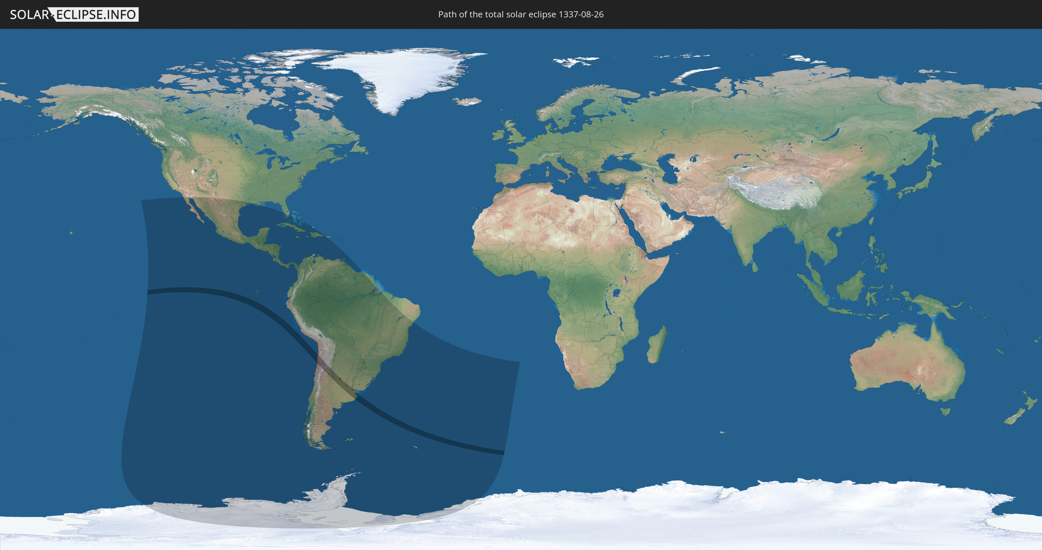
Die Sonnenfinsternis am 26.08.1337 kann man in 40 Ländern als partielle Sonnenfinsternis beobachten.
Der Finsternispfad verläuft durch 2 Länder. Nur in diesen Ländern ist sie als totale Sonnenfinsternis zu sehen.
In den folgenden Ländern ist die Sonnenfinsternis total zu sehen
 Chile
Chile
 Argentinien
In den folgenden Ländern ist die Sonnenfinsternis partiell zu sehen
 Antarktika
 Vereinigte Staaten
 United States Minor Outlying Islands
 Pitcairninseln
 Mexiko
 Chile
Chile
 Guatemala
 Ecuador
 El Salvador
 Honduras
 Belize
 Nicaragua
 Costa Rica
 Kuba
Kuba
 Panama
 Kolumbien
 Kaimaninseln
 Peru
Peru
 Bahamas
 Jamaika
 Haiti
Haiti
 Brasilien
 Argentinien
 Venezuela
 Turks- und Caicosinseln
 Dominikanische Republik
 Aruba
Aruba
 Bolivien
 Puerto Rico
 Paraguay
 Trinidad und Tobago
 Grenada
 St. Vincent und die Grenadinen
 Falklandinseln
 Guyana
 Uruguay
 Suriname
 Französisch-Guayana
 Südgeorgien und die Südlichen Sandwichinseln
 St. Helena
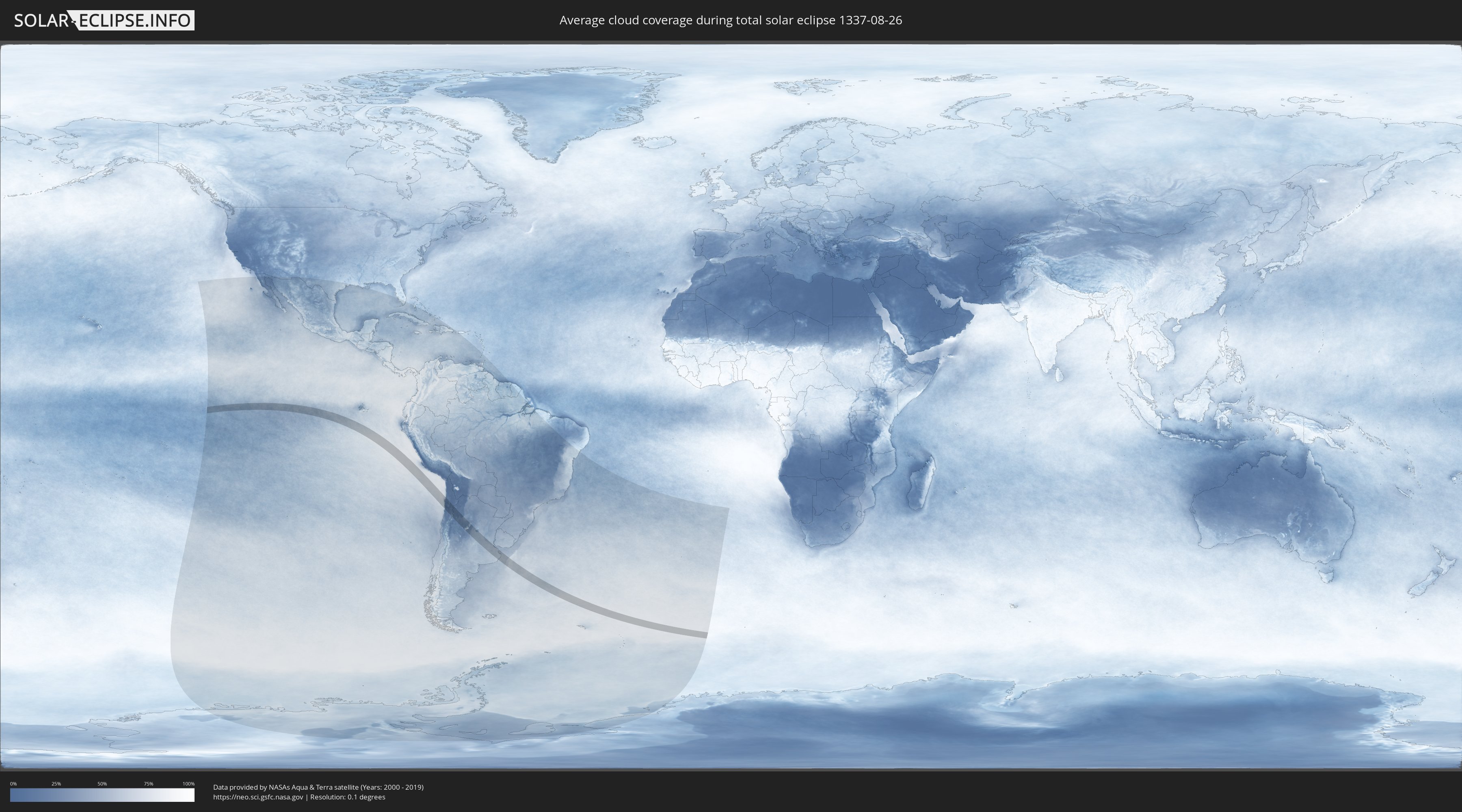
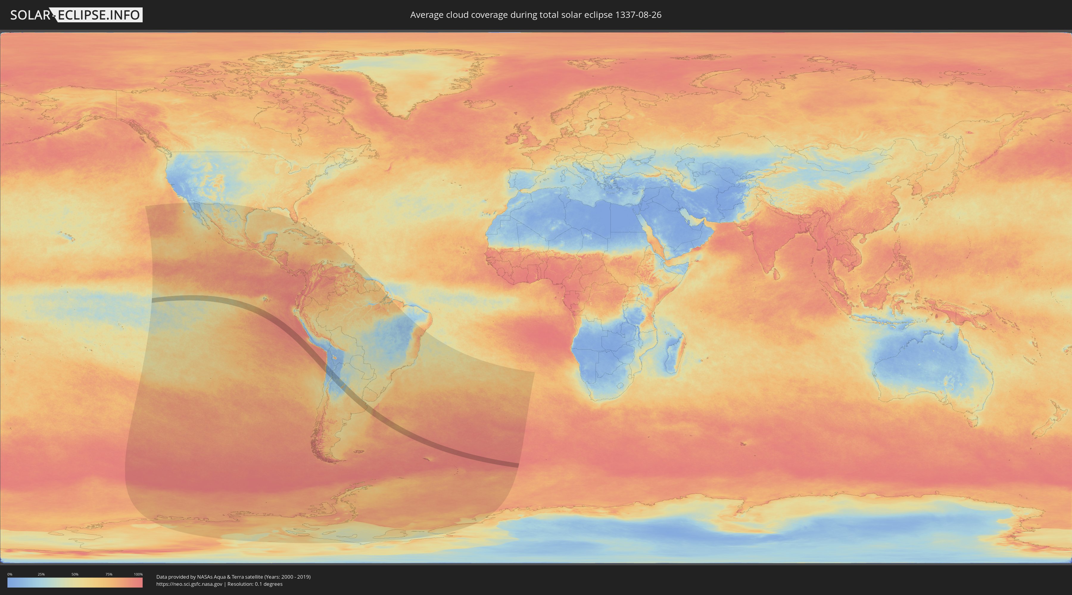
Wie wird das Wetter während der totalen Sonnenfinsternis am 26.08.1337?
Wo ist der beste Ort, um die totale Sonnenfinsternis vom 26.08.1337 zu beobachten?
Die folgenden Karten zeigen die durchschnittliche Bewölkung für den Tag, an dem die totale Sonnenfinsternis
stattfindet. Mit Hilfe der Karten lässt sich der Ort entlang des Finsternispfades eingrenzen,
der die besten Aussichen auf einen klaren wolkenfreien Himmel bietet.
Trotzdem muss man immer lokale Gegenenheiten beachten und sollte sich genau über das Wetter an seinem
gewählten Beobachtungsort informieren.
Die Daten stammen von den beiden NASA-Satelliten
AQUA und TERRA
und wurden über einen Zeitraum von 19 Jahren (2000 - 2019) gemittelt.
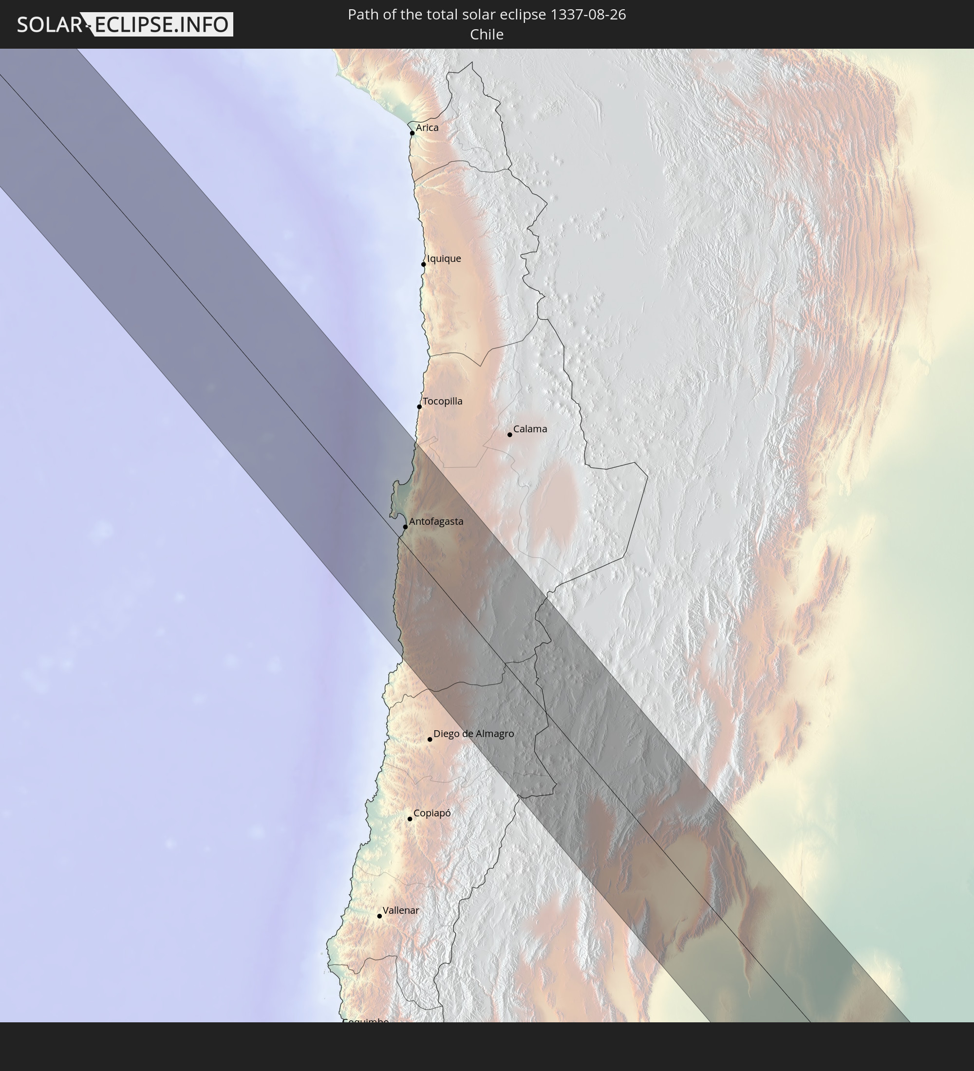
Detaillierte Länderkarten
 Chile
Chile
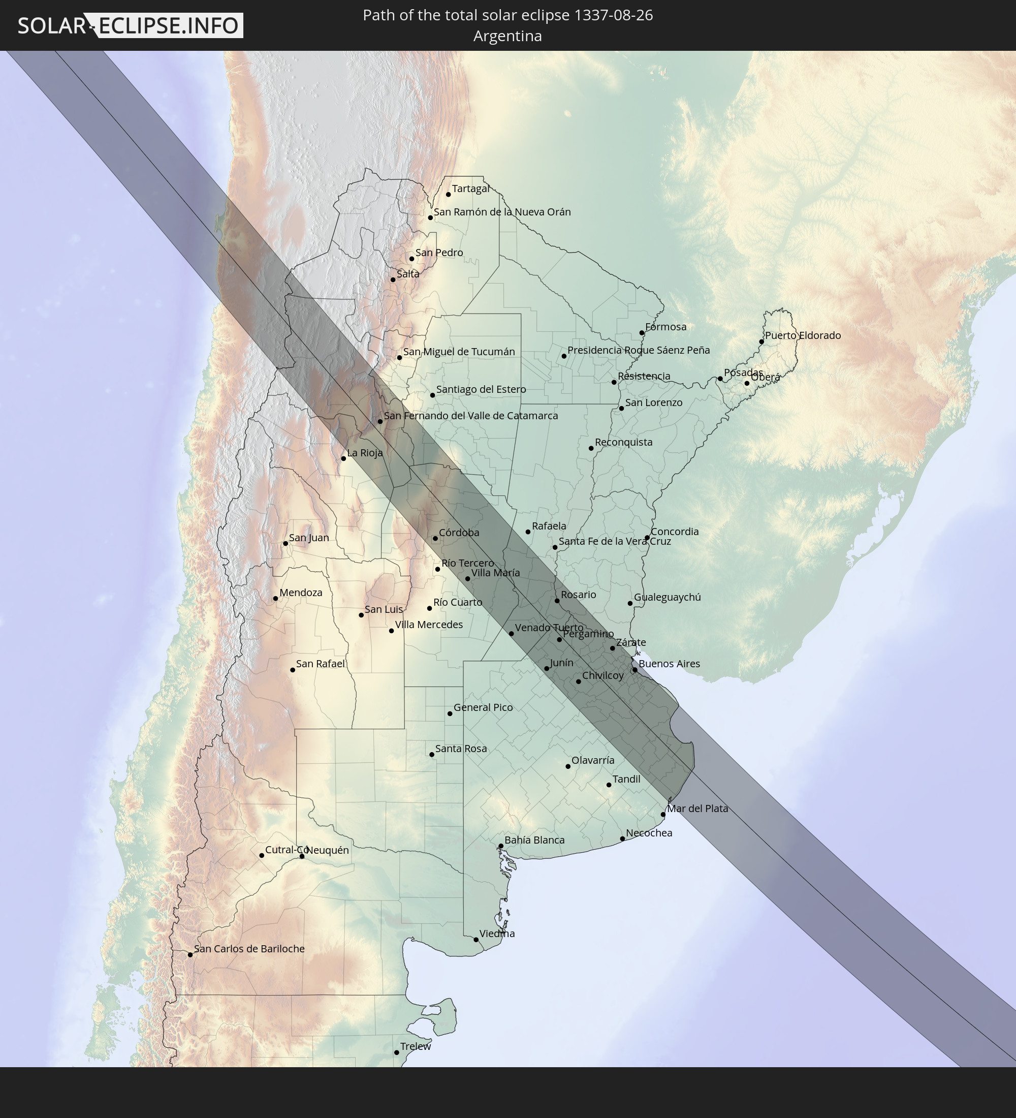
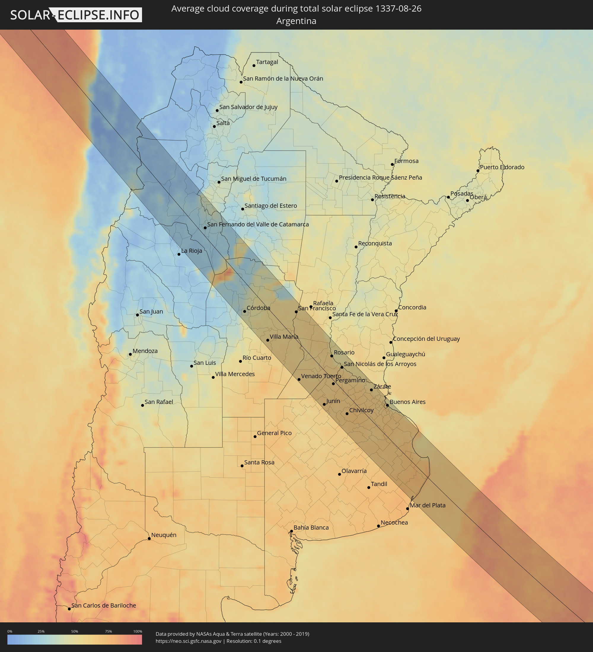 Argentinien
Orte im Finsternispfad
Die nachfolgene Tabelle zeigt Städte und Orte mit mehr als 5.000 Einwohnern, die sich im Finsternispfad befinden. Städte mit mehr als 100.000 Einwohnern sind dick gekennzeichnet. Mit einem Klick auf den Ort öffnet sich eine Detailkarte die die Lage des jeweiligen Ortes zusammen mit dem Verlauf der zentralen Finsternis präsentiert.
| Ort | Typ | Dauer der Verfinsterung | Ortszeit bei maximaler Verfinsterung | Entfernung zur Zentrallinie | Ø Bewölkung |
|
Antofagasta, Antofagasta
|
total | - | 11:42:55 UTC-04:42 | 17 km | 20% |
|
Fiambalá, Catamarca Province
|
total | - | 12:20:09 UTC-04:16 | 58 km | 25% |
|
Tinogasta, Catamarca Province
|
total | - | 12:20:47 UTC-04:16 | 81 km | 21% |
|
Arauco, La Rioja Province
|
total | - | 12:22:50 UTC-04:16 | 61 km | 21% |
|
Andalgalá, Catamarca Province
|
total | - | 12:22:12 UTC-04:16 | 46 km | 25% |
|
Capayán, Catamarca Province
|
total | - | 12:24:19 UTC-04:16 | 19 km | 19% |
|
Huillapima, Catamarca Province
|
total | - | 12:24:23 UTC-04:16 | 11 km | 22% |
|
San Fernando del Valle de Catamarca, Catamarca Province
|
total | - | 12:24:21 UTC-04:16 | 22 km | 25% |
|
La Cocha, Tucumán Province
|
total | - | 12:23:42 UTC-04:16 | 88 km | 38% |
|
Los Altos, Catamarca Province
|
total | - | 12:24:13 UTC-04:16 | 74 km | 34% |
|
Icaño, Catamarca Province
|
total | - | 12:25:44 UTC-04:16 | 23 km | 22% |
|
Recreo, Catamarca Province
|
total | - | 12:26:40 UTC-04:16 | 17 km | 24% |
|
Villa de Soto, Cordoba Province
|
total | - | 12:28:52 UTC-04:16 | 94 km | 25% |
|
Cruz del Eje, Cordoba Province
|
total | - | 12:29:01 UTC-04:16 | 70 km | 27% |
|
Capilla del Monte, Cordoba Province
|
total | - | 12:29:38 UTC-04:16 | 60 km | 31% |
|
Villa Carlos Paz, Cordoba Province
|
total | - | 12:30:23 UTC-04:16 | 99 km | 31% |
|
La Cumbre, Cordoba Province
|
total | - | 12:29:50 UTC-04:16 | 66 km | 32% |
|
Huerta Grande, Cordoba Province
|
total | - | 12:29:58 UTC-04:16 | 73 km | 30% |
|
La Falda, Cordoba Province
|
total | - | 12:29:59 UTC-04:16 | 74 km | 30% |
|
Cosquín, Cordoba Province
|
total | - | 12:30:13 UTC-04:16 | 84 km | 28% |
|
Malagueño, Cordoba Province
|
total | - | 12:30:40 UTC-04:16 | 92 km | 39% |
|
Deán Funes, Cordoba Province
|
total | - | 12:29:20 UTC-04:16 | 15 km | 30% |
|
La Calera, Cordoba Province
|
total | - | 12:30:33 UTC-04:16 | 82 km | 39% |
|
Río Ceballos, Cordoba Province
|
total | - | 12:30:20 UTC-04:16 | 68 km | 35% |
|
Unquillo, Cordoba Province
|
total | - | 12:30:26 UTC-04:16 | 72 km | 35% |
|
Salsipuedes, Cordoba Province
|
total | - | 12:30:21 UTC-04:16 | 64 km | 34% |
|
Villa Allende, Cordoba Province
|
total | - | 12:30:33 UTC-04:16 | 75 km | 39% |
|
Córdoba, Cordoba Province
|
total | - | 12:30:53 UTC-04:16 | 76 km | 45% |
|
Jesús María, Cordoba Province
|
total | - | 12:30:28 UTC-04:16 | 38 km | 41% |
|
Malvinas Argentinas, Cordoba Province
|
total | - | 12:31:01 UTC-04:16 | 65 km | 43% |
|
Monte Cristo, Cordoba Province
|
total | - | 12:31:10 UTC-04:16 | 54 km | 48% |
|
Río Segundo, Cordoba Province
|
total | - | 12:31:36 UTC-04:16 | 74 km | 52% |
|
Pilar, Cordoba Province
|
total | - | 12:31:41 UTC-04:16 | 74 km | 52% |
|
Laguna Larga, Cordoba Province
|
total | - | 12:31:55 UTC-04:16 | 75 km | 52% |
|
Villa del Totoral, Cordoba Province
|
total | - | 12:30:51 UTC-04:16 | 1 km | 51% |
|
Villa Ojo de Agua, Santiago del Estero Province
|
total | - | 12:29:10 UTC-04:16 | 100 km | 27% |
|
Oncativo, Cordoba Province
|
total | - | 12:32:17 UTC-04:16 | 77 km | 52% |
|
Oliva, Cordoba Province
|
total | - | 12:32:36 UTC-04:16 | 78 km | 53% |
|
Santa Rosa de Río Primero, Cordoba Province
|
total | - | 12:31:46 UTC-04:16 | 1 km | 52% |
|
Villa Nueva, Cordoba Province
|
total | - | 12:33:34 UTC-04:16 | 85 km | 60% |
|
Villa María, Cordoba Province
|
total | - | 12:33:33 UTC-04:16 | 82 km | 60% |
|
Arroyito, Cordoba Province
|
total | - | 12:32:39 UTC-04:16 | 4 km | 55% |
|
Las Varillas, Cordoba Province
|
total | - | 12:33:43 UTC-04:16 | 6 km | 57% |
|
Bell Ville, Cordoba Province
|
total | - | 12:34:39 UTC-04:16 | 60 km | 61% |
|
Justiniano Posse, Cordoba Province
|
total | - | 12:34:58 UTC-04:16 | 78 km | 61% |
|
Balnearia, Cordoba Province
|
total | - | 12:32:45 UTC-04:16 | 62 km | 55% |
|
Monte Maíz, Cordoba Province
|
total | - | 12:35:27 UTC-04:16 | 97 km | 61% |
|
Devoto, Cordoba Province
|
total | - | 12:33:47 UTC-04:16 | 58 km | 56% |
|
Leones, Cordoba Province
|
total | - | 12:35:18 UTC-04:16 | 35 km | 60% |
|
Corral de Bustos, Cordoba Province
|
total | - | 12:36:10 UTC-04:16 | 74 km | 64% |
|
Marcos Juárez, Cordoba Province
|
total | - | 12:35:37 UTC-04:16 | 25 km | 58% |
|
San Francisco, Cordoba Province
|
total | - | 12:34:10 UTC-04:16 | 72 km | 60% |
|
Chañar Ladeado, Santa Fe Province
|
total | - | 12:36:26 UTC-04:16 | 67 km | 61% |
|
Venado Tuerto, Santa Fe Province
|
total | - | 12:37:00 UTC-04:16 | 93 km | 61% |
|
San Jorge, Santa Fe Province
|
total | - | 12:35:04 UTC-04:16 | 53 km | 59% |
|
Cruz Alta, Cordoba Province
|
total | - | 12:36:26 UTC-04:16 | 27 km | 57% |
|
El Trébol, Santa Fe Province
|
total | - | 12:35:40 UTC-04:16 | 41 km | 60% |
|
Villa Cañás, Santa Fe Province
|
total | - | 12:37:50 UTC-04:16 | 88 km | 60% |
|
Armstrong, Santa Fe Province
|
total | - | 12:36:29 UTC-04:16 | 4 km | 58% |
|
Las Rosas, Santa Fe Province
|
total | - | 12:36:10 UTC-04:16 | 28 km | 60% |
|
Las Parejas, Santa Fe Province
|
total | - | 12:36:30 UTC-04:16 | 17 km | 60% |
|
Firmat, Santa Fe Province
|
total | - | 12:37:25 UTC-04:16 | 39 km | 61% |
|
Cañada de Gómez, Santa Fe Province
|
total | - | 12:36:50 UTC-04:16 | 16 km | 59% |
|
Gálvez, Santa Fe Province
|
total | - | 12:36:12 UTC-04:16 | 87 km | 61% |
|
Totoras, Santa Fe Province
|
total | - | 12:36:55 UTC-04:16 | 49 km | 61% |
|
Casilda, Santa Fe Province
|
total | - | 12:37:26 UTC-04:16 | 14 km | 59% |
|
Carcarañá, Santa Fe Province
|
total | - | 12:37:15 UTC-04:16 | 29 km | 61% |
|
Junín, Buenos Aires
|
total | - | 12:39:25 UTC-04:16 | 87 km | 65% |
|
Roldán, Santa Fe Province
|
total | - | 12:37:39 UTC-04:16 | 43 km | 61% |
|
Funes, Santa Fe Province
|
total | - | 12:37:49 UTC-04:16 | 48 km | 61% |
|
Pérez, Santa Fe Province
|
total | - | 12:37:58 UTC-04:16 | 45 km | 60% |
|
Fray Luis A. Beltrán, Santa Fe Province
|
total | - | 12:37:48 UTC-04:16 | 63 km | 58% |
|
Capitán Bermúdez, Santa Fe Province
|
total | - | 12:37:51 UTC-04:16 | 62 km | 58% |
|
Granadero Baigorria, Santa Fe Province
|
total | - | 12:37:54 UTC-04:16 | 59 km | 63% |
|
Gobernador Gálvez, Santa Fe Province
|
total | - | 12:38:12 UTC-04:16 | 51 km | 57% |
|
Rosario, Santa Fe Province
|
total | - | 12:38:07 UTC-04:16 | 58 km | 54% |
|
Pergamino, Buenos Aires
|
total | - | 12:39:14 UTC-04:16 | 9 km | 62% |
|
Arroyo Seco, Santa Fe Province
|
total | - | 12:38:32 UTC-04:16 | 51 km | 64% |
|
Chacabuco, Buenos Aires
|
total | - | 12:40:09 UTC-04:16 | 60 km | 62% |
|
Villa Constitución, Santa Fe Province
|
total | - | 12:38:53 UTC-04:16 | 57 km | 57% |
|
San Nicolás de los Arroyos, Buenos Aires
|
total | - | 12:39:09 UTC-04:16 | 56 km | 58% |
|
Chivilcoy, Buenos Aires
|
total | - | 12:41:04 UTC-04:16 | 49 km | 68% |
|
Mercedes, Buenos Aires
|
total | - | 12:41:40 UTC-04:16 | 9 km | 66% |
|
Luján, Buenos Aires
|
total | - | 12:42:03 UTC-04:16 | 37 km | 66% |
|
Zárate, Buenos Aires
|
total | - | 12:41:41 UTC-04:16 | 78 km | 64% |
|
Campana, Buenos Aires
|
total | - | 12:41:51 UTC-04:16 | 77 km | 66% |
|
Pontevedra, Buenos Aires
|
total | - | 12:42:48 UTC-04:16 | 50 km | 62% |
|
Morón, Buenos Aires
|
total | - | 12:42:49 UTC-04:16 | 62 km | 62% |
|
Tigre, Buenos Aires
|
total | - | 12:42:39 UTC-04:16 | 83 km | 63% |
|
San Isidro, Buenos Aires
|
total | - | 12:42:46 UTC-04:16 | 82 km | 65% |
|
Villa Santa Rita, Buenos Aires F.D.
|
total | - | 12:42:59 UTC-04:16 | 75 km | 68% |
|
Villa Lugano, Buenos Aires F.D.
|
total | - | 12:43:03 UTC-04:16 | 70 km | 65% |
|
Colegiales, Buenos Aires F.D.
|
total | - | 12:42:59 UTC-04:16 | 80 km | 66% |
|
Adrogué, Buenos Aires
|
total | - | 12:43:18 UTC-04:16 | 66 km | 64% |
|
Retiro, Buenos Aires F.D.
|
total | - | 12:43:05 UTC-04:16 | 83 km | 66% |
|
Buenos Aires, Buenos Aires F.D.
|
total | - | 12:43:07 UTC-04:16 | 81 km | 66% |
|
Quilmes, Buenos Aires
|
total | - | 12:43:24 UTC-04:16 | 80 km | 64% |
|
La Plata, Buenos Aires
|
total | - | 12:44:01 UTC-04:16 | 85 km | 68% |
|
Dolores, Buenos Aires
|
total | - | 12:45:40 UTC-04:16 | 6 km | 72% |
|
Villa Gesell, Buenos Aires
|
total | - | 12:47:24 UTC-04:16 | 36 km | 69% |
|
San Clemente del Tuyú, Buenos Aires
|
total | - | 12:47:00 UTC-04:16 | 51 km | 69% |