Totale Sonnenfinsternis vom 26.06.1424
| Wochentag: | Samstag |
| Maximale Dauer der Verfinsterung: | 04m14s |
| Maximale Breite des Finsternispfades: | 270 km |
| Saroszyklus: | 127 |
| Bedeckungsgrad: | 100% |
| Magnitude: | 1.0629 |
| Gamma: | 0.6425 |
Wo kann man die Sonnenfinsternis vom 26.06.1424 sehen?
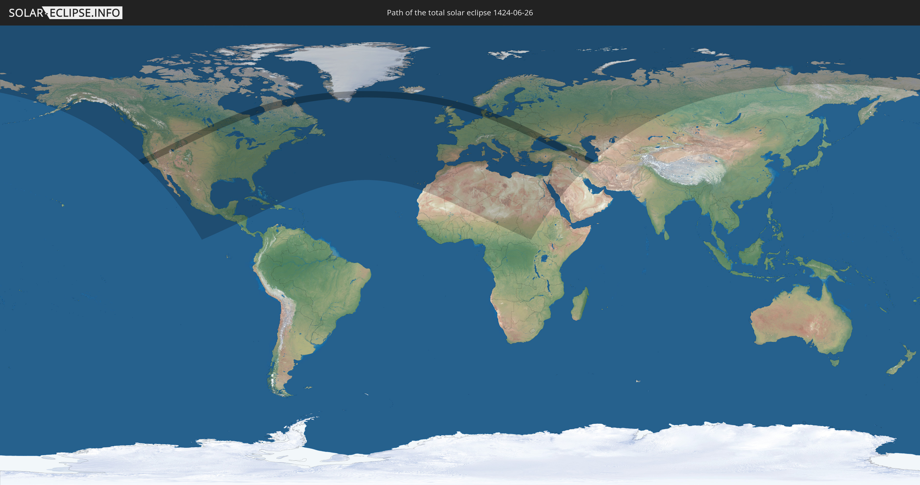
Die Sonnenfinsternis am 26.06.1424 kann man in 99 Ländern als partielle Sonnenfinsternis beobachten.
Der Finsternispfad verläuft durch 19 Länder. Nur in diesen Ländern ist sie als totale Sonnenfinsternis zu sehen.
In den folgenden Ländern ist die Sonnenfinsternis total zu sehen
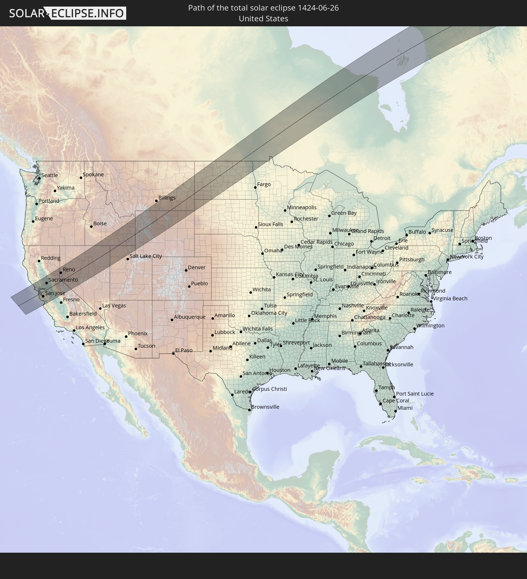 Vereinigte Staaten
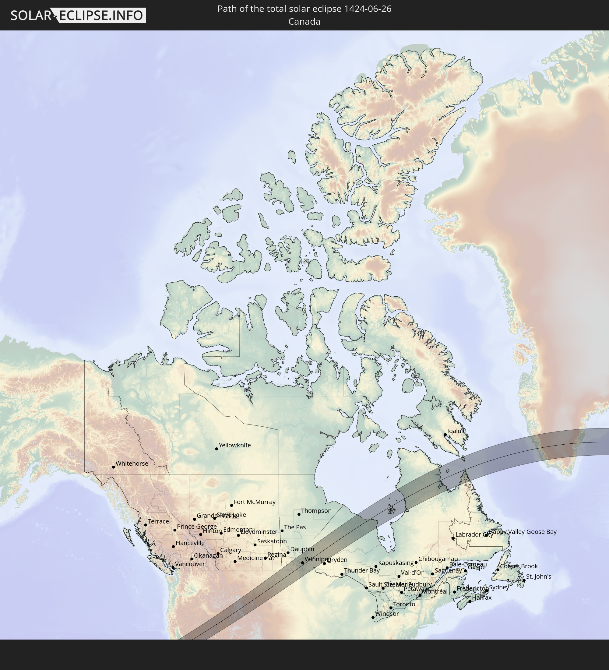 Kanada
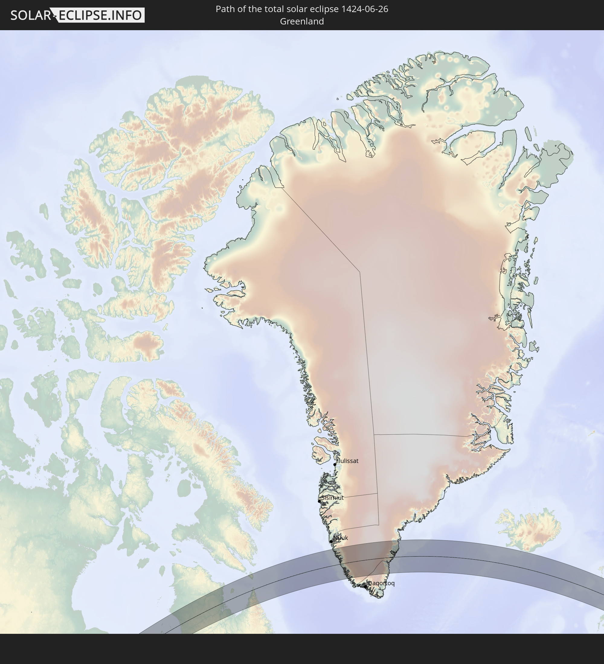 Grönland
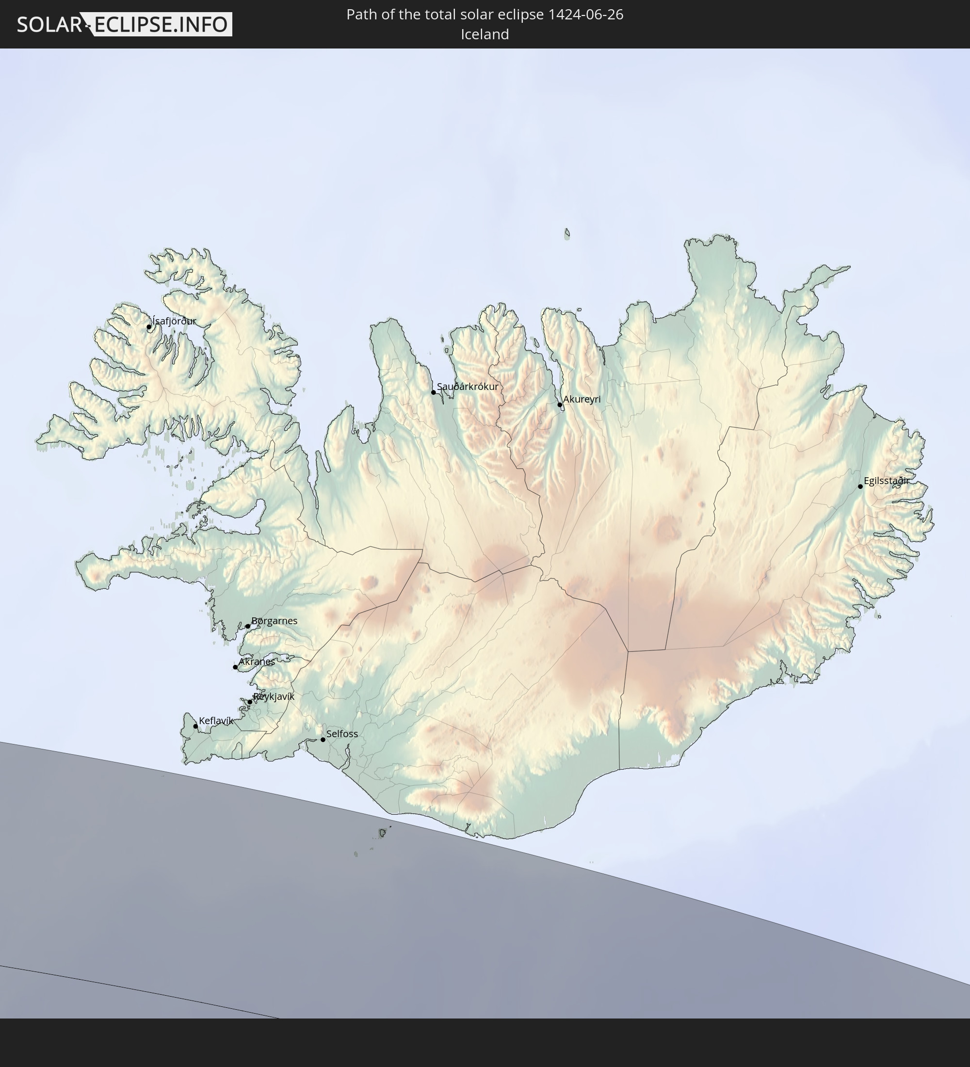 Island
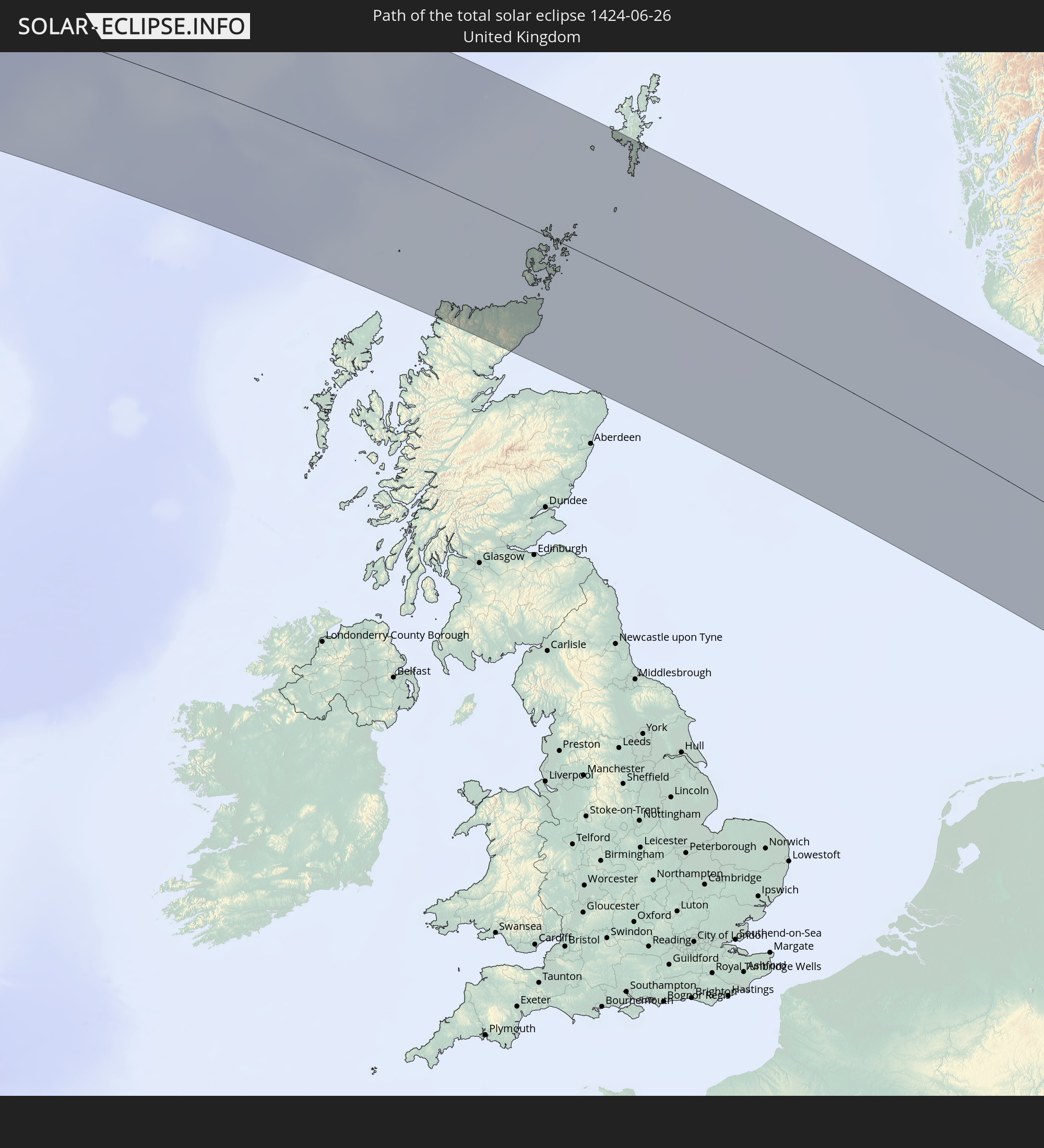 Vereinigtes Königreich
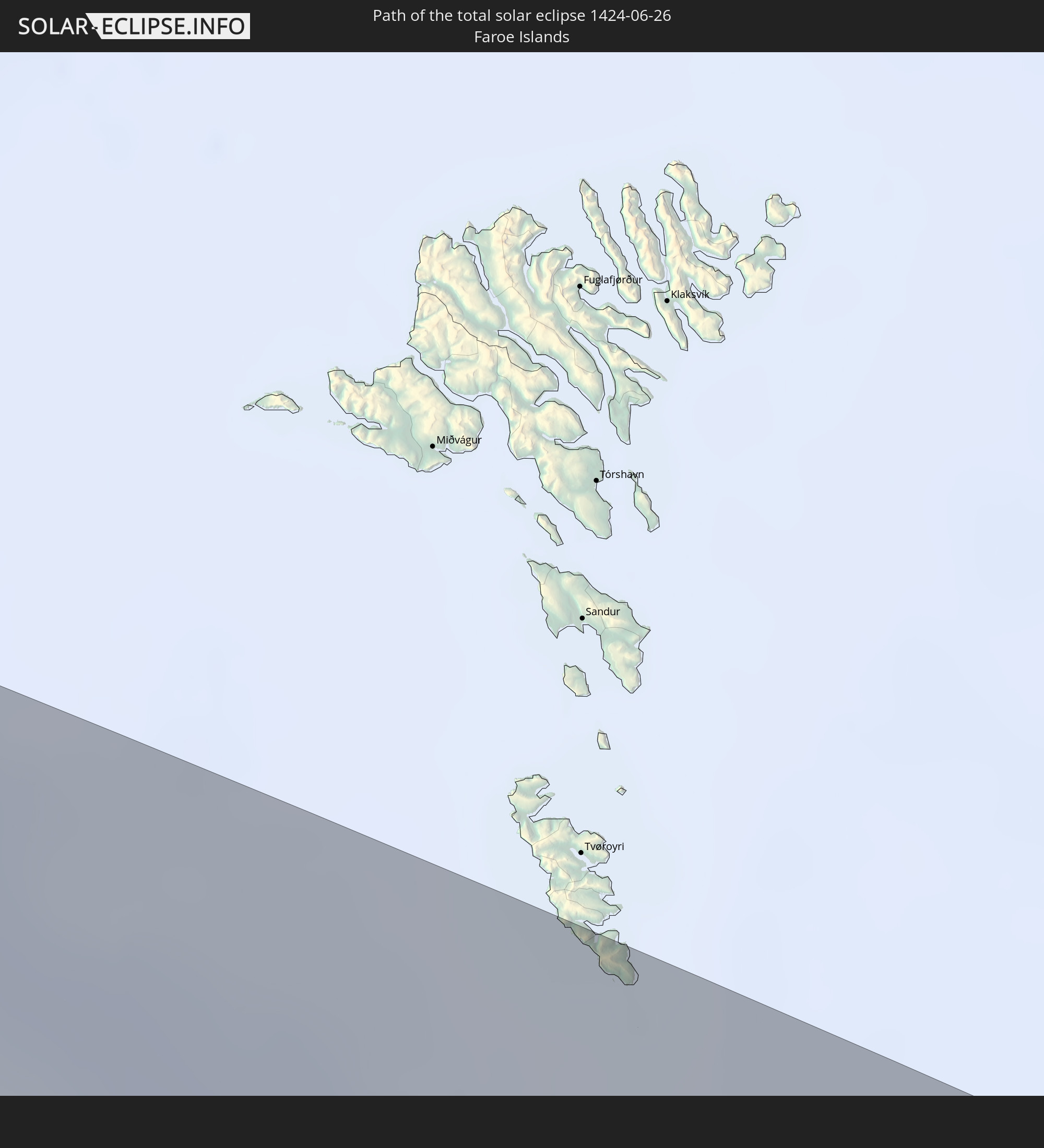 Färöer
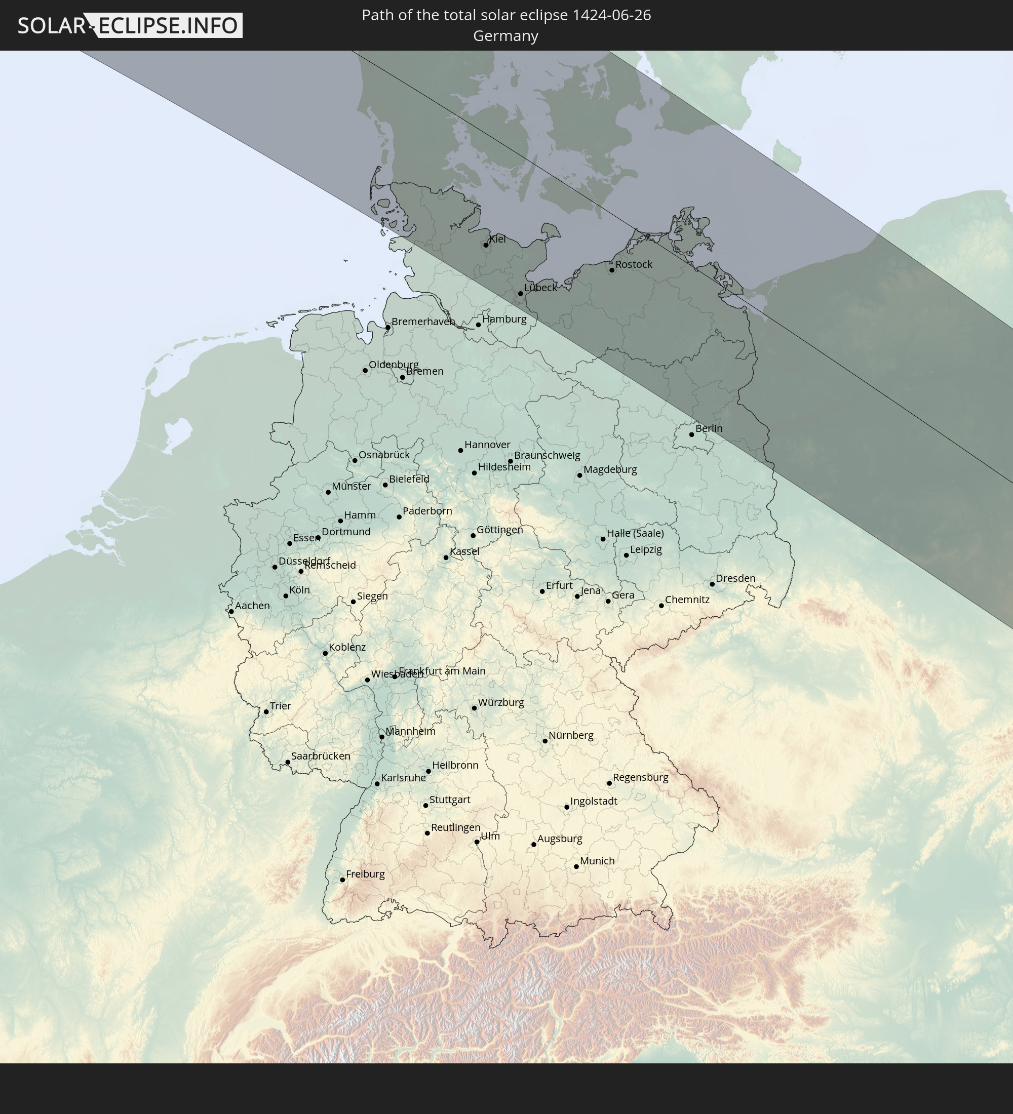 Deutschland
 Dänemark
 Schweden
 Polen
Polen
 Slowakei
 Rumänien
 Ukraine
 Türkei
 Moldawien
 Georgien
 Armenien
 Iran
Iran
 Aserbaidschan
In den folgenden Ländern ist die Sonnenfinsternis partiell zu sehen
 Russland
 Vereinigte Staaten
 United States Minor Outlying Islands
 Kanada
 Mexiko
 Grönland
 Guatemala
 El Salvador
 Honduras
 Belize
 Nicaragua
 Kuba
Kuba
 Kaimaninseln
 Bahamas
 Jamaika
 Haiti
Haiti
 Turks- und Caicosinseln
 Dominikanische Republik
 Bermuda
 Saint-Pierre und Miquelon
 Portugal
 Island
 Spanien
 Mauretanien
 Marokko
 Mali
Mali
 Irland
 Spitzbergen
 Algerien
 Vereinigtes Königreich
 Färöer
 Gibraltar
 Frankreich
 Isle of Man
 Guernsey
 Jersey
 Niger
Niger
 Andorra
 Belgien
 Nigeria
 Niederlande
 Norwegen
 Luxemburg
 Deutschland
 Schweiz
 Italien
 Monaco
 Tunesien
 Dänemark
 Kamerun
 Libyen
 Liechtenstein
 Österreich
 Schweden
 Tschechien
 San Marino
 Vatikanstadt
 Slowenien
 Tschad
 Kroatien
 Polen
Polen
 Malta
Malta
 Zentralafrikanische Republik
 Bosnien und Herzegowina
 Ungarn
 Slowakei
 Montenegro
 Serbien
 Albanien
 Åland Islands
 Griechenland
 Rumänien
 Mazedonien
 Finnland
 Litauen
 Lettland
 Estland
 Sudan
Sudan
 Ukraine
 Bulgarien
 Weißrussland
 Ägypten
 Türkei
 Moldawien
 Republik Zypern
 Staat Palästina
 Israel
 Saudi-Arabien
 Jordanien
 Libanon
 Syrien
 Irak
Irak
 Georgien
 Armenien
 Iran
Iran
 Aserbaidschan
 Kasachstan
 Turkmenistan
 Usbekistan
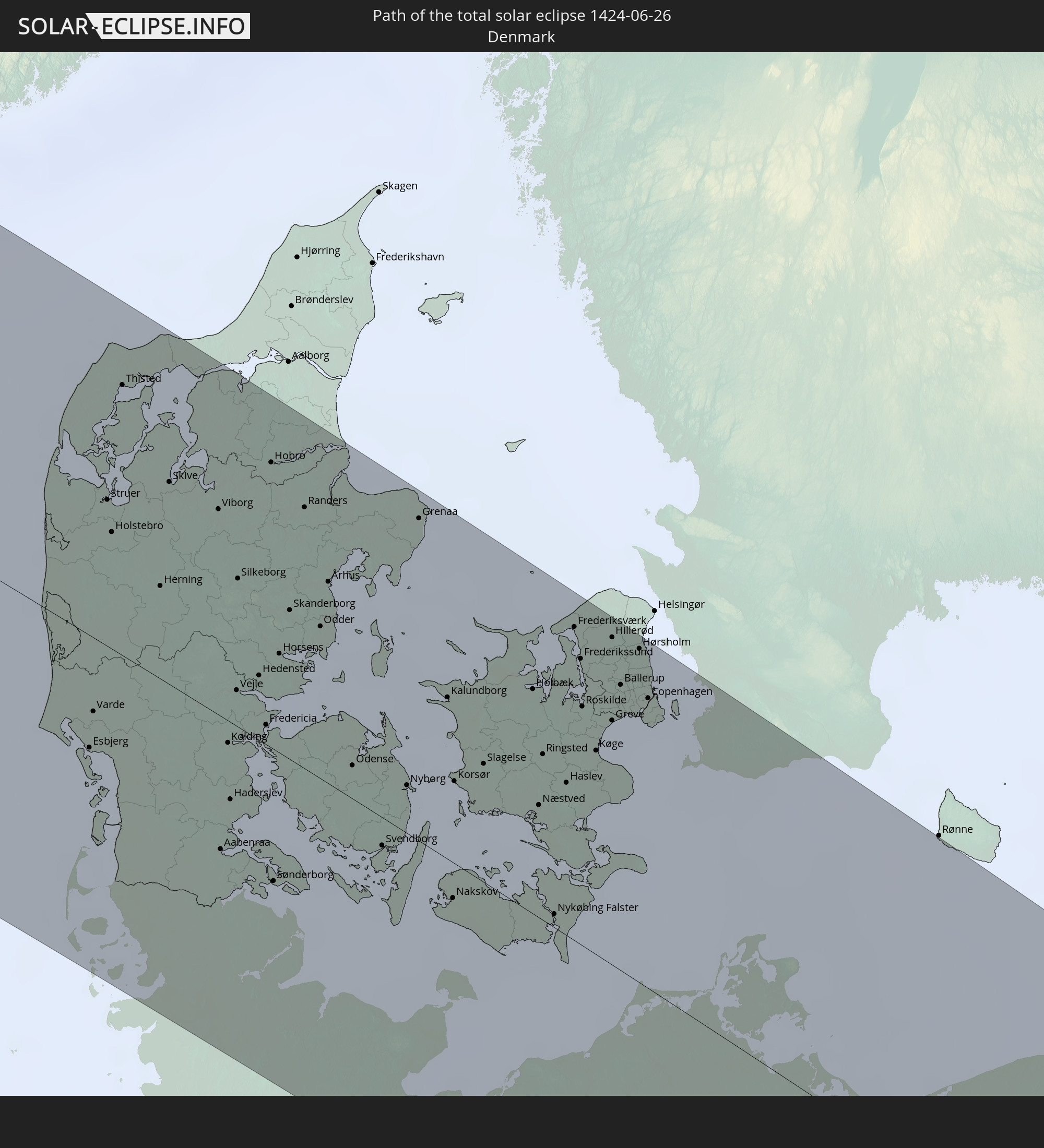
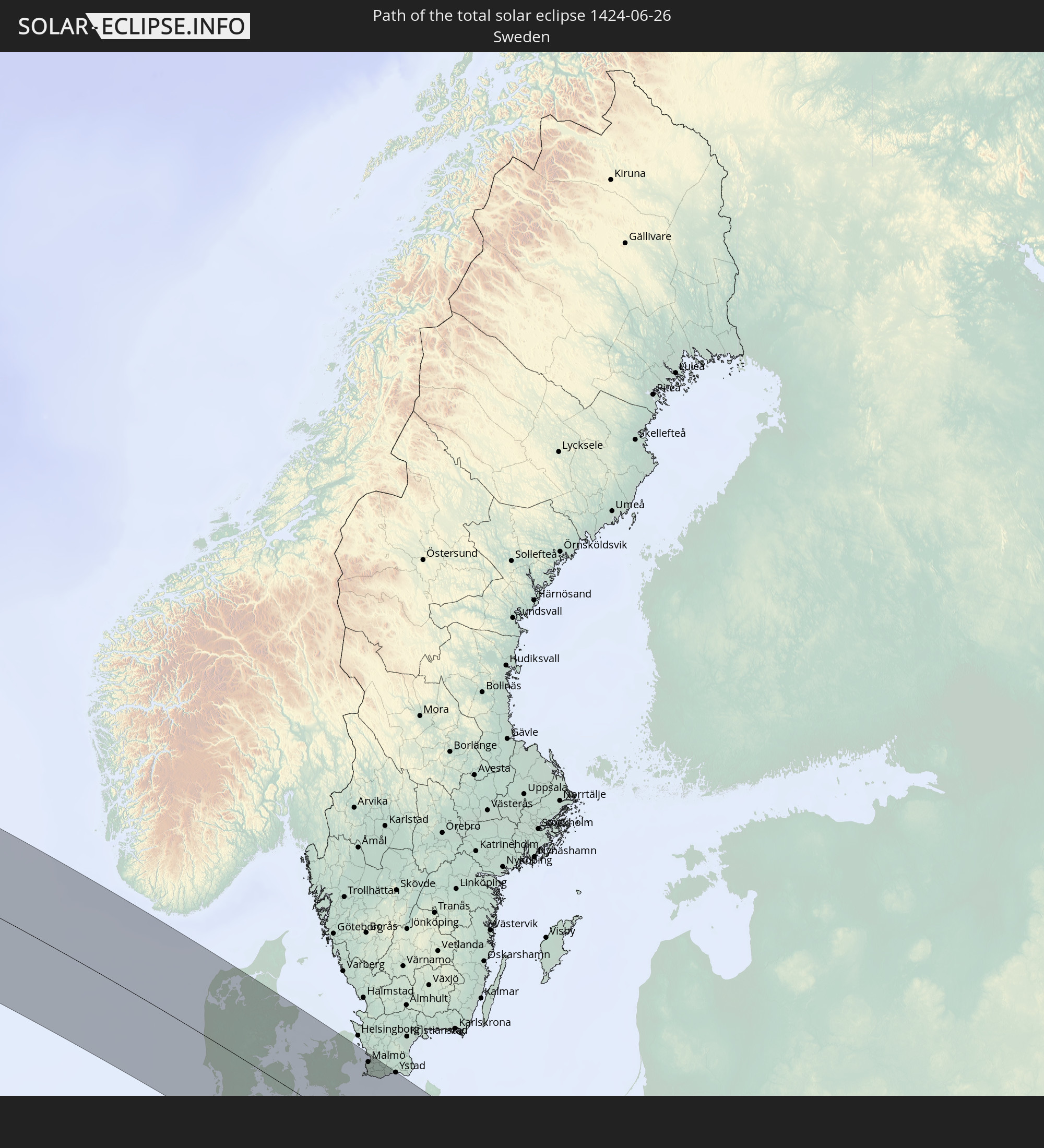
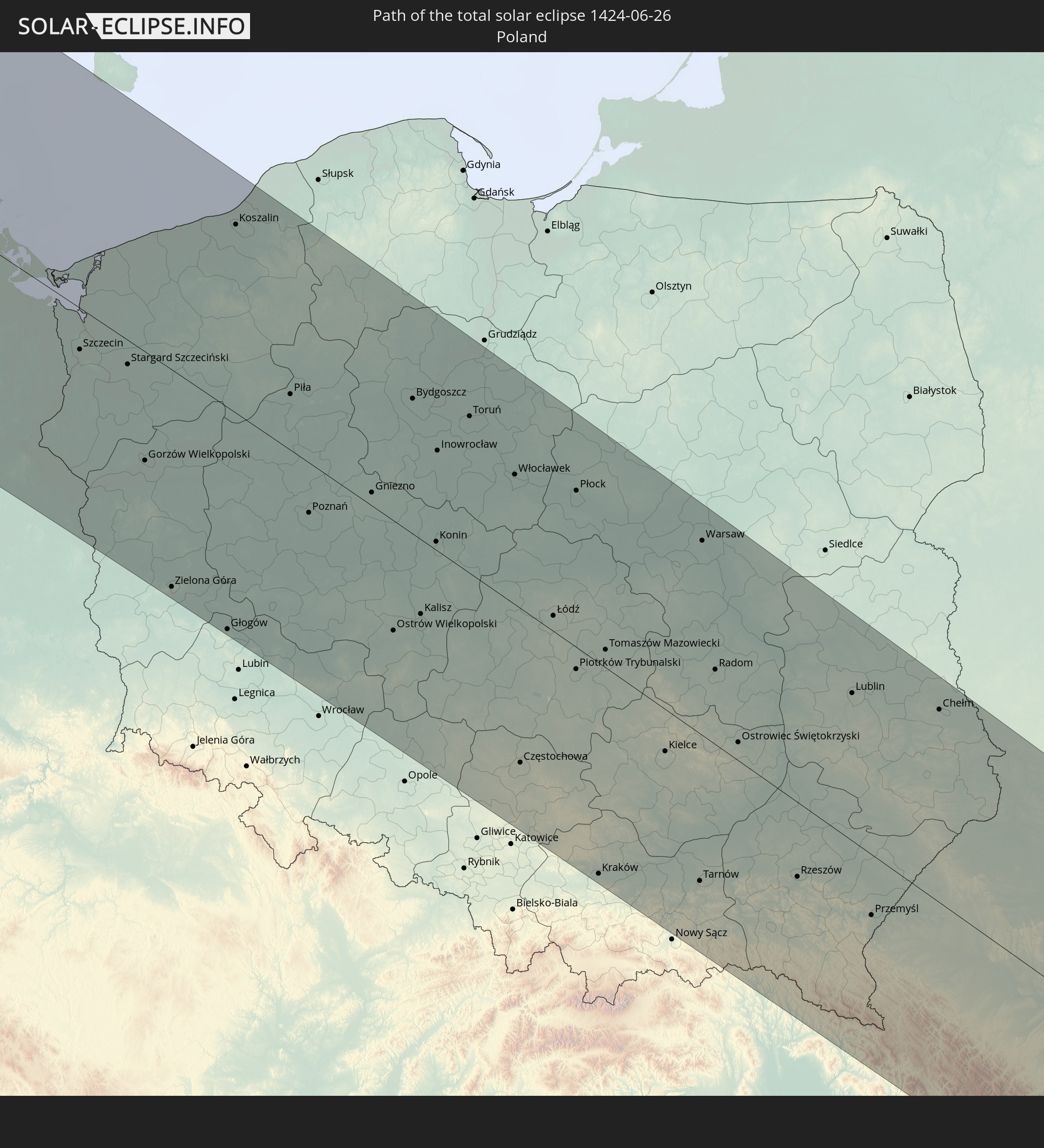
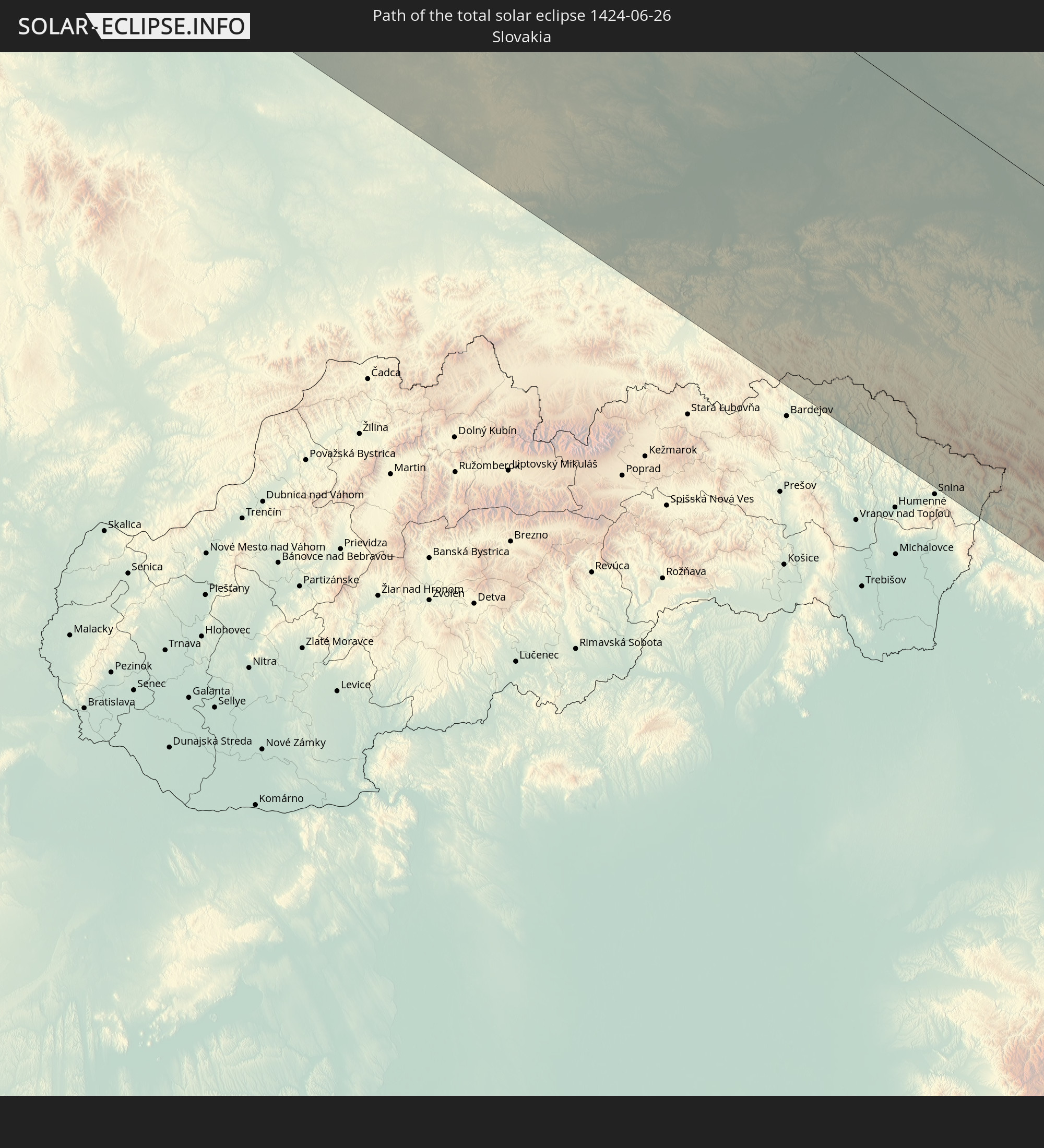
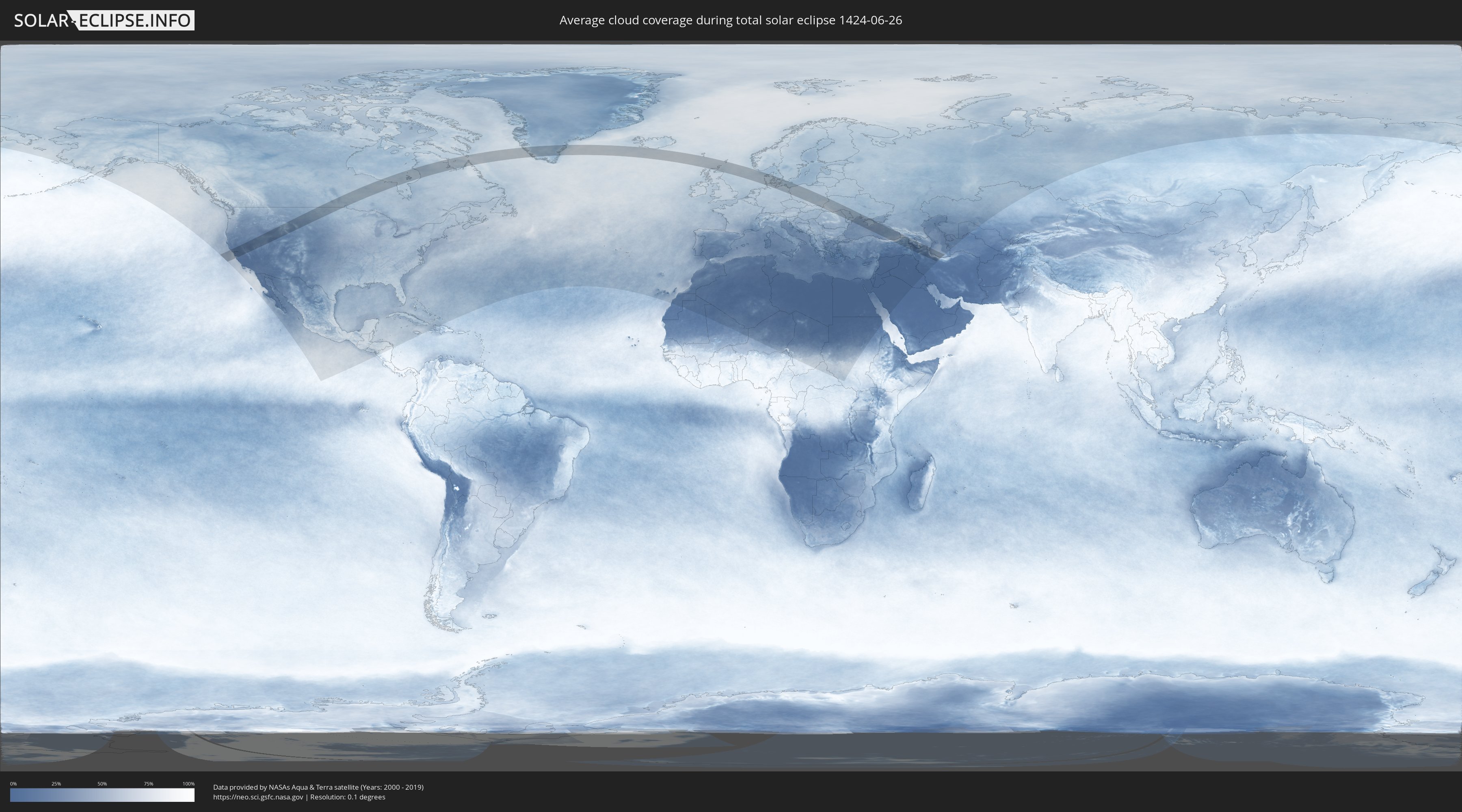
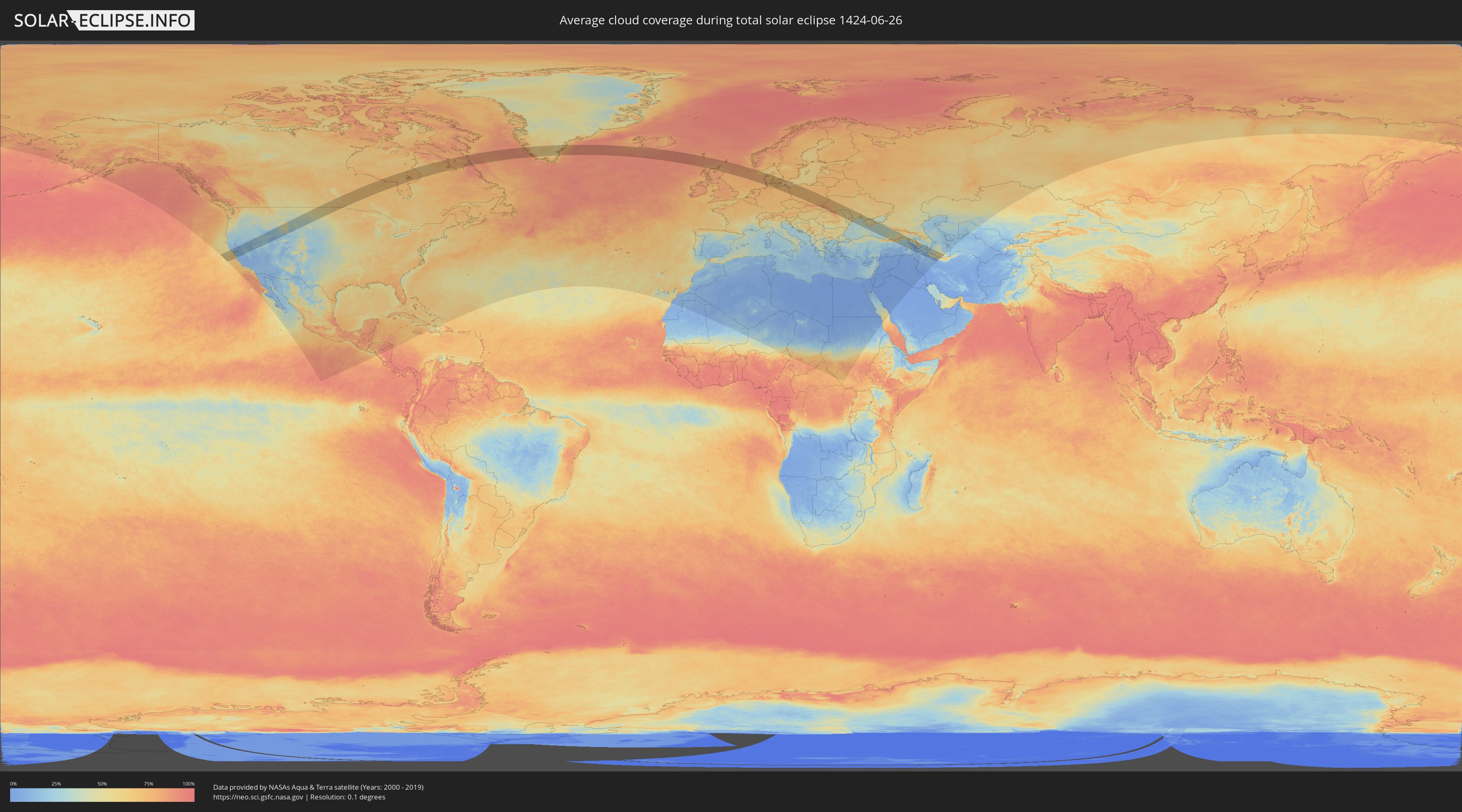
Wie wird das Wetter während der totalen Sonnenfinsternis am 26.06.1424?
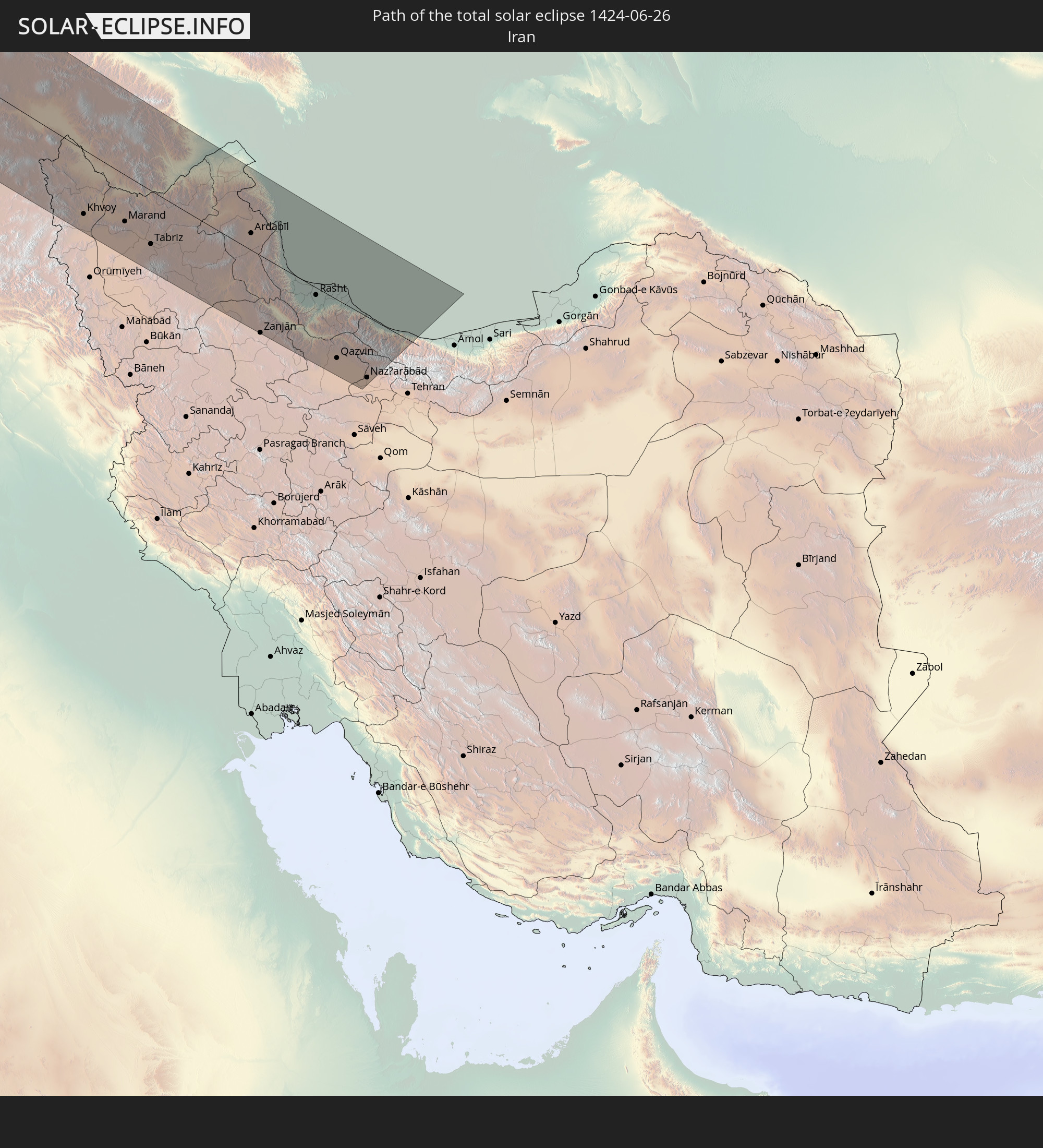
Wo ist der beste Ort, um die totale Sonnenfinsternis vom 26.06.1424 zu beobachten?
Die folgenden Karten zeigen die durchschnittliche Bewölkung für den Tag, an dem die totale Sonnenfinsternis
stattfindet. Mit Hilfe der Karten lässt sich der Ort entlang des Finsternispfades eingrenzen,
der die besten Aussichen auf einen klaren wolkenfreien Himmel bietet.
Trotzdem muss man immer lokale Gegenenheiten beachten und sollte sich genau über das Wetter an seinem
gewählten Beobachtungsort informieren.
Die Daten stammen von den beiden NASA-Satelliten
AQUA und TERRA
und wurden über einen Zeitraum von 19 Jahren (2000 - 2019) gemittelt.
Detaillierte Länderkarten
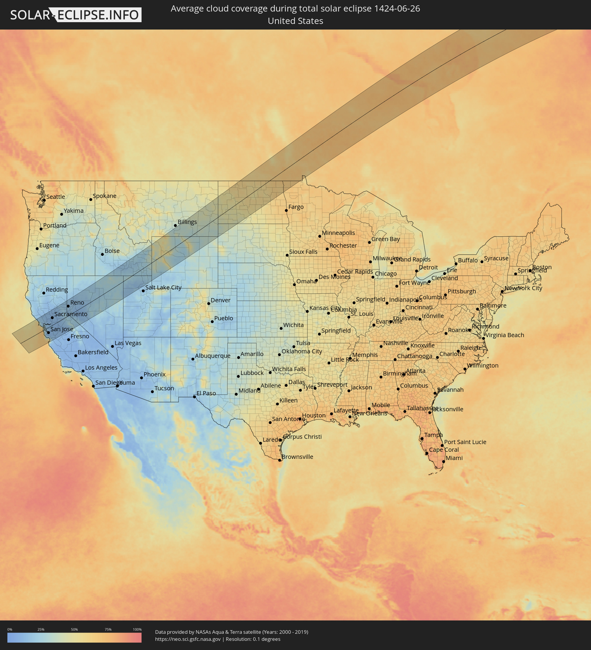 Vereinigte Staaten
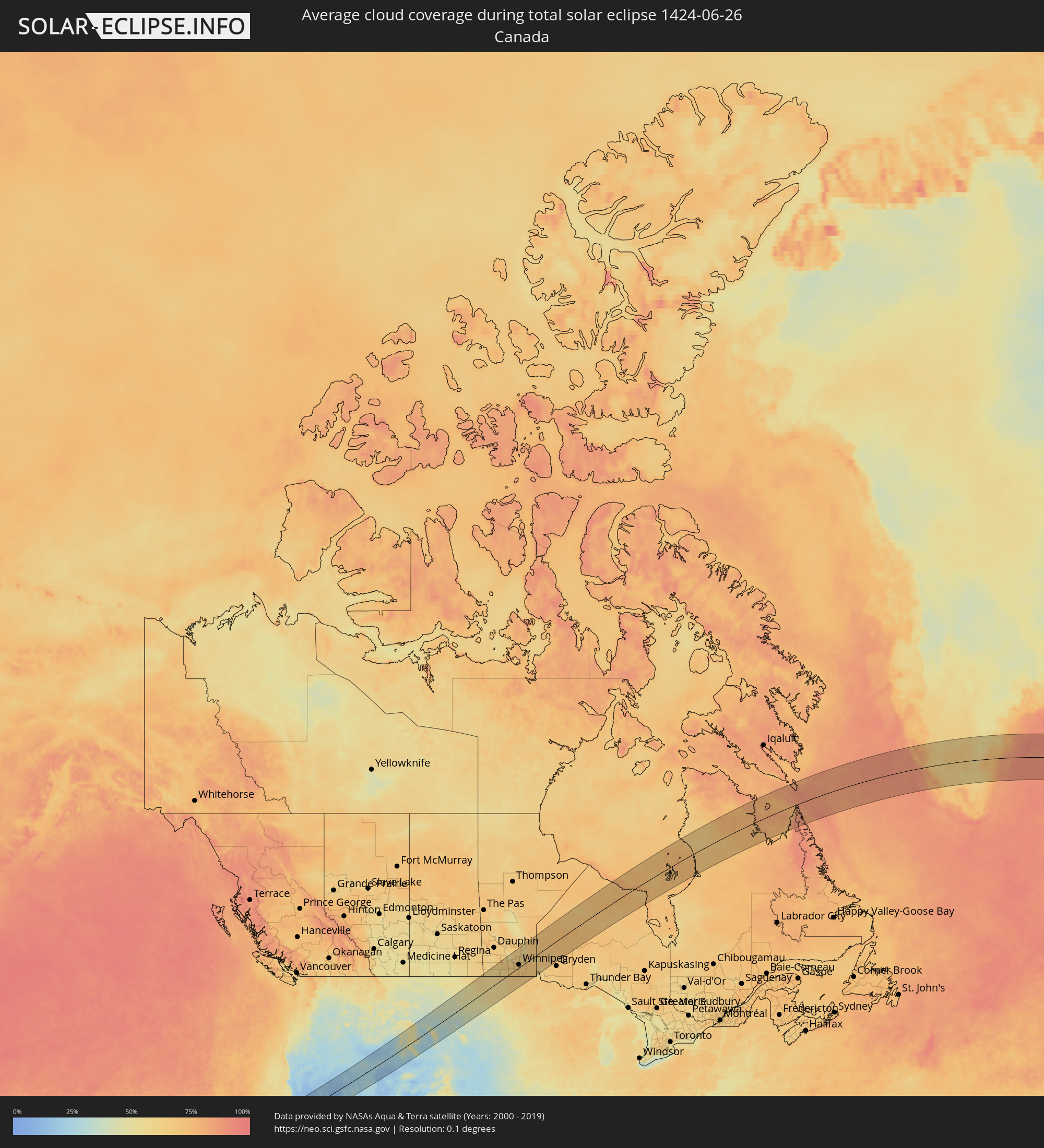 Kanada
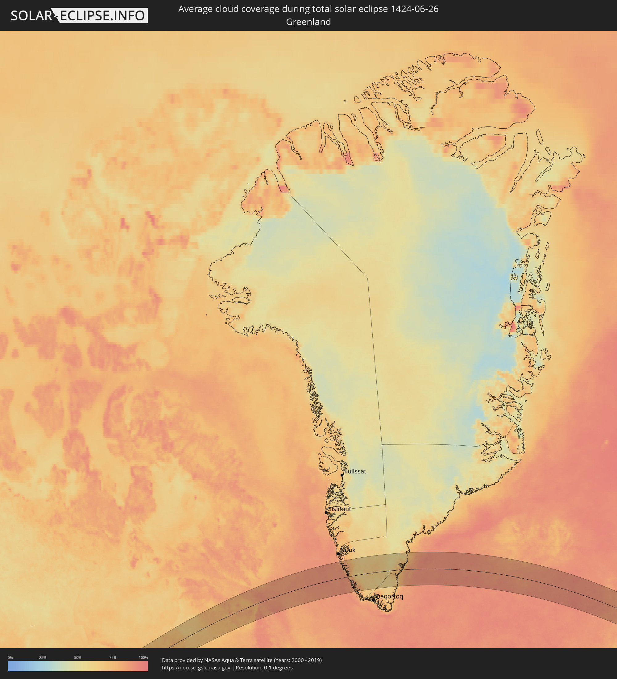 Grönland
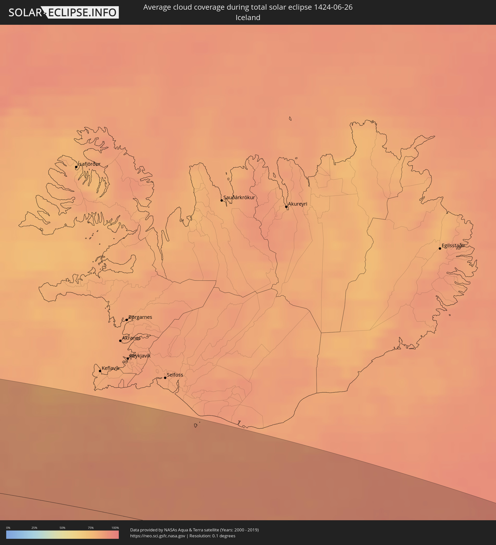 Island
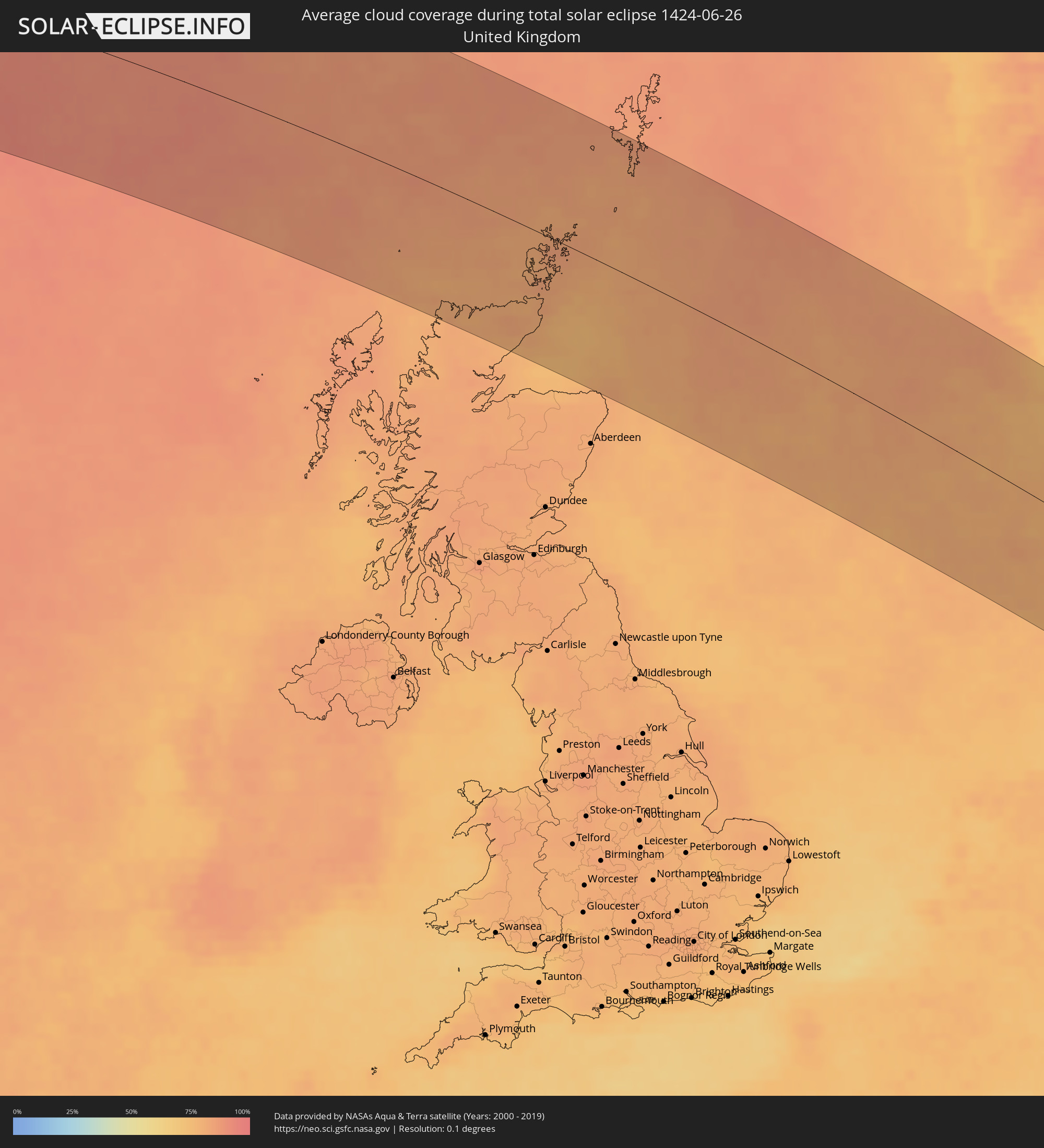 Vereinigtes Königreich
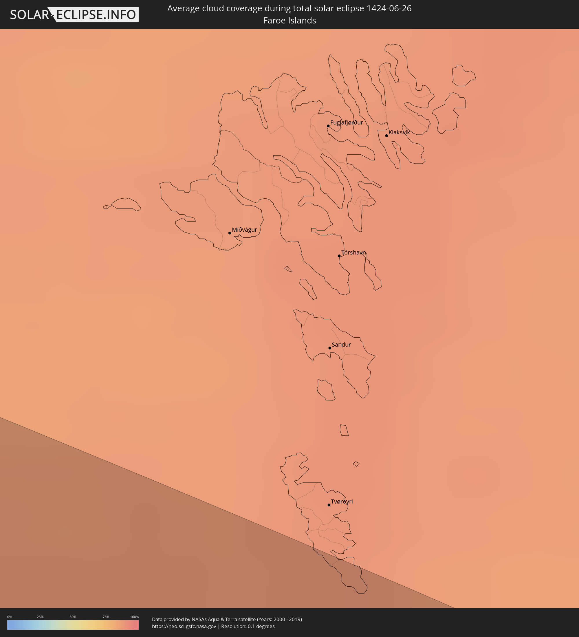 Färöer
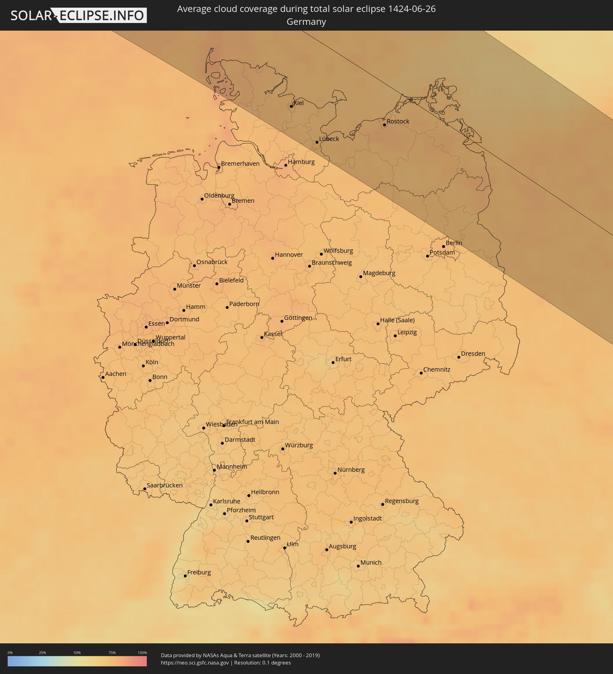 Deutschland
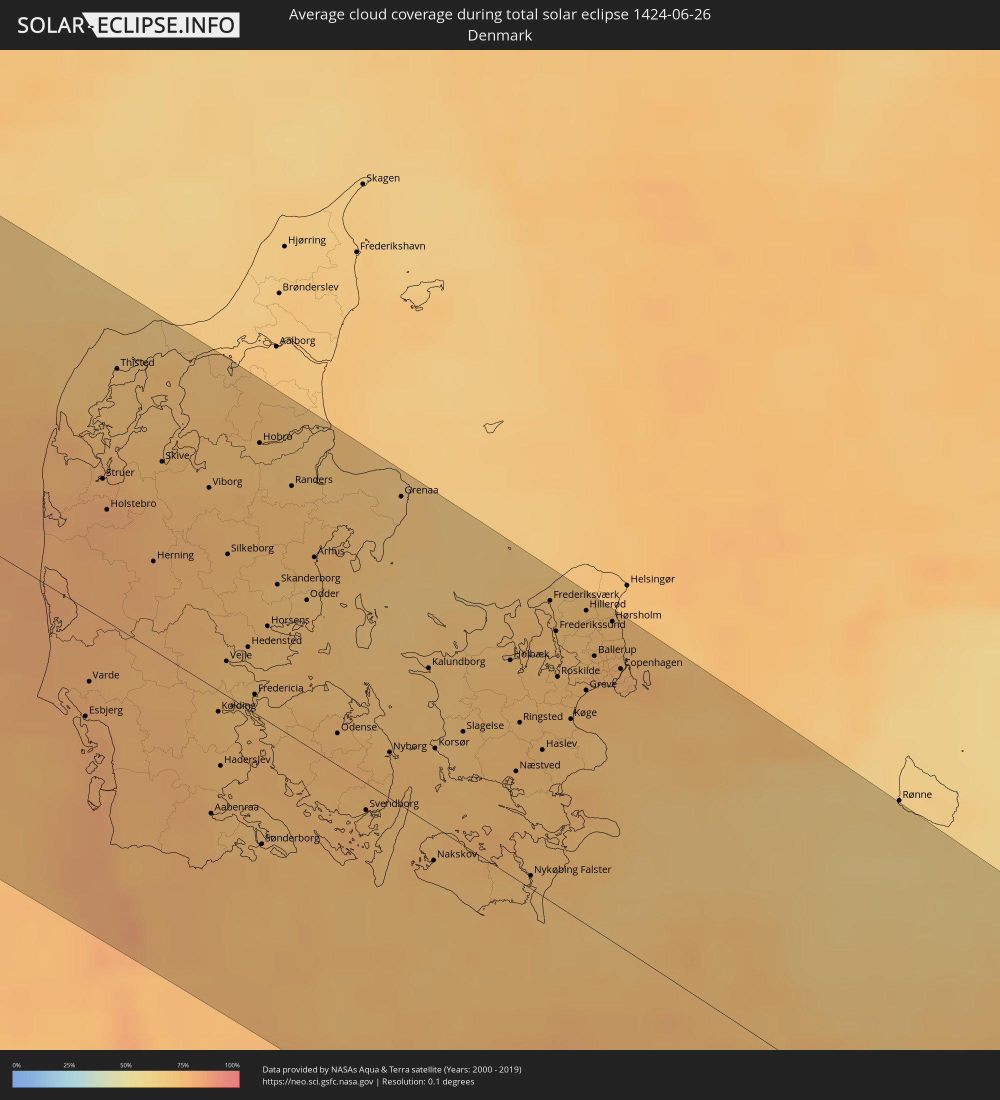 Dänemark
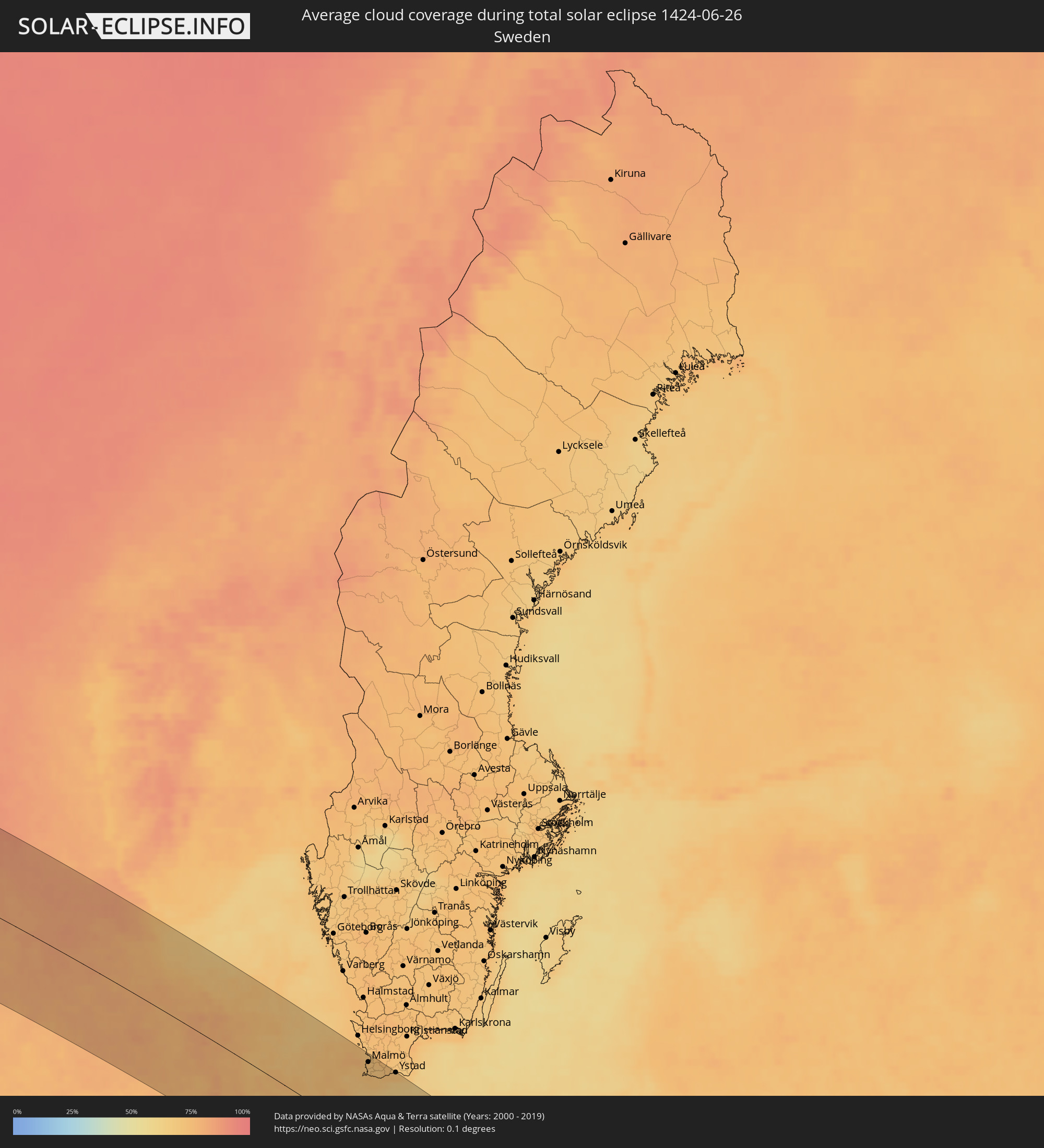 Schweden
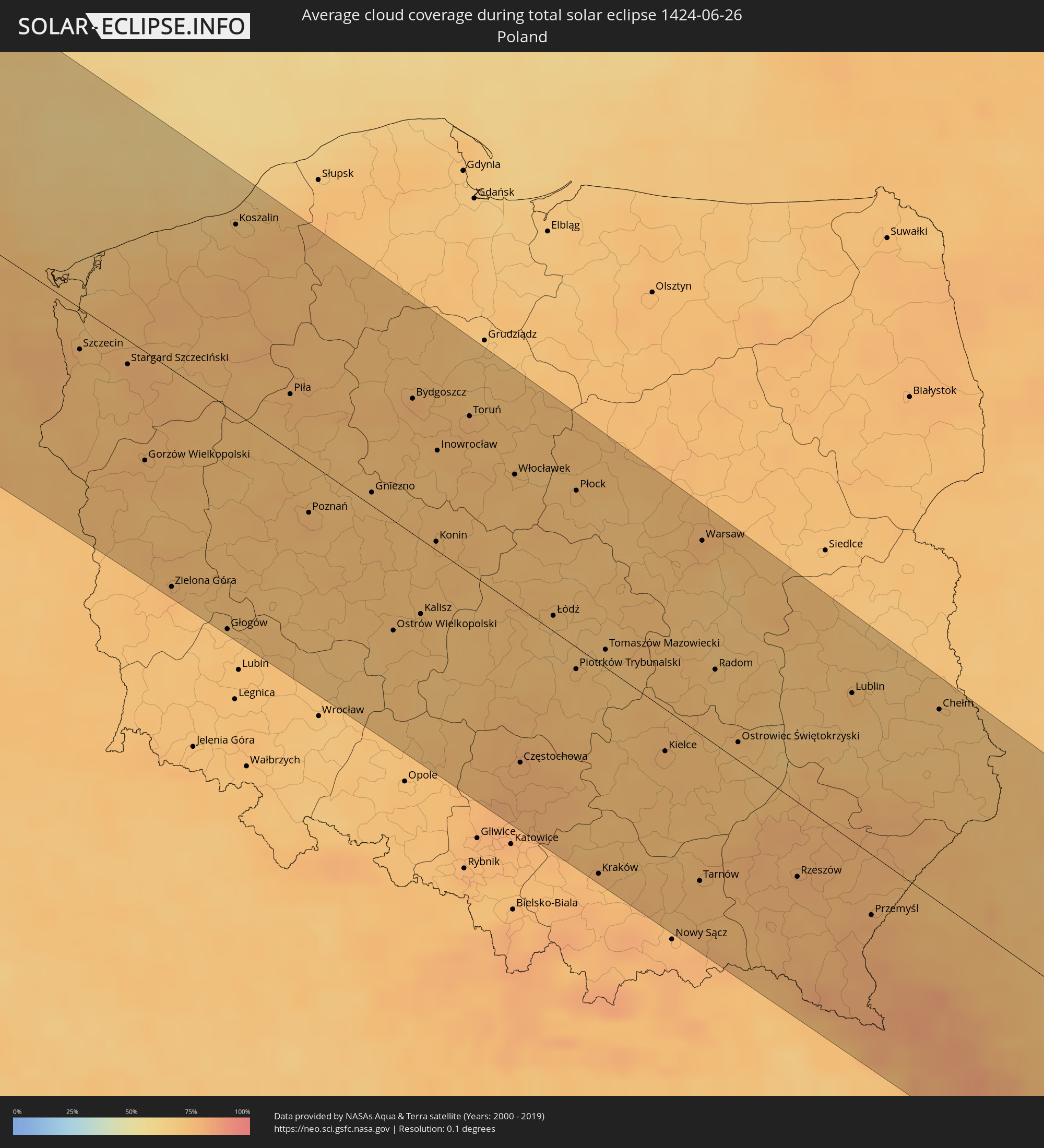 Polen
Polen
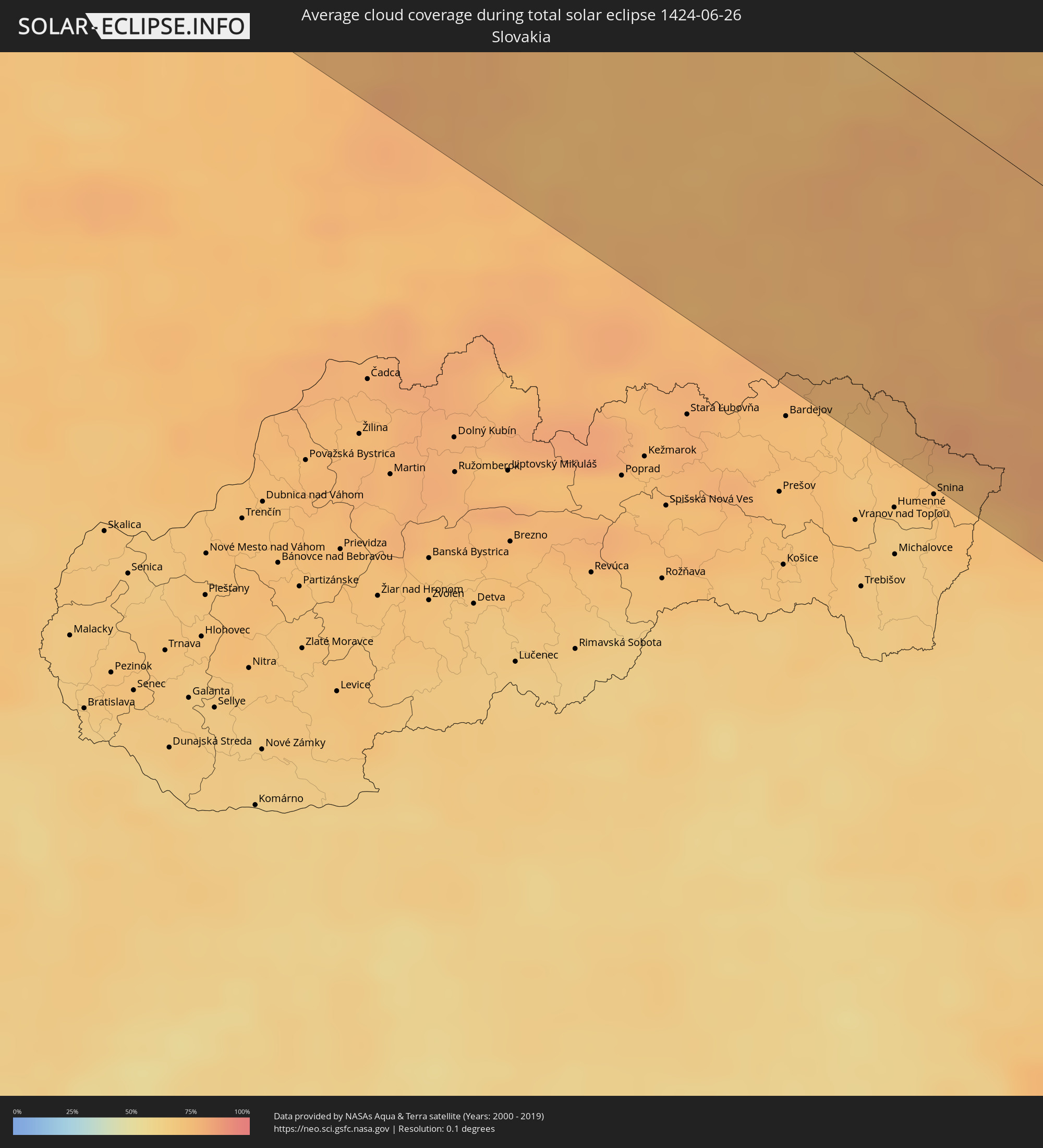 Slowakei
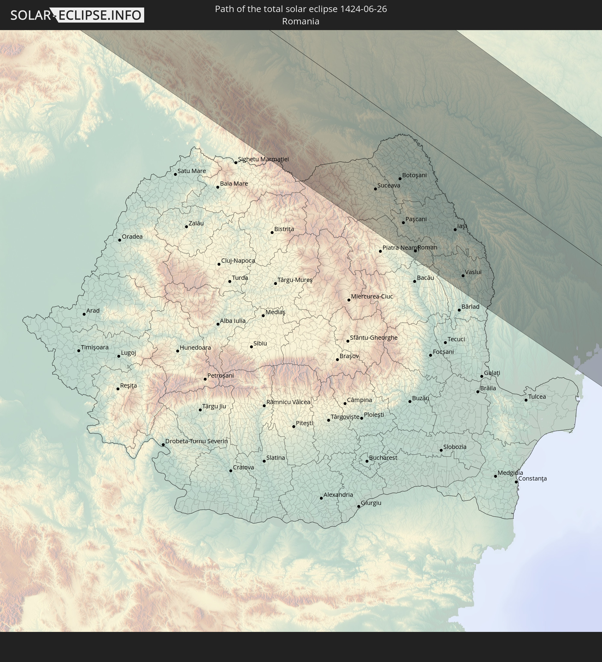
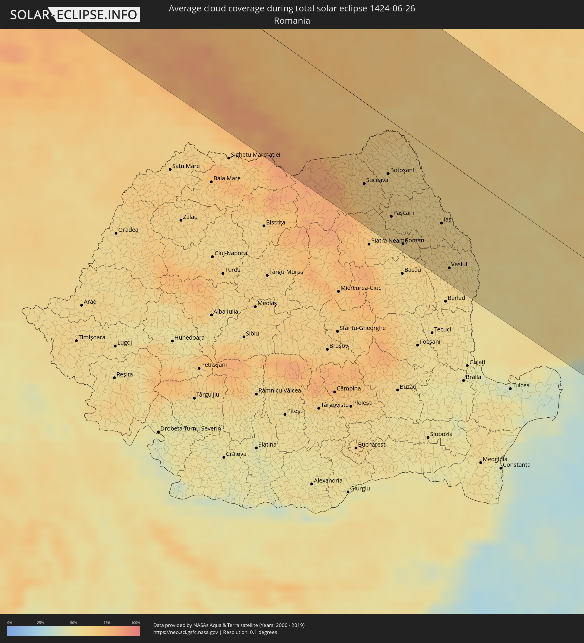 Rumänien
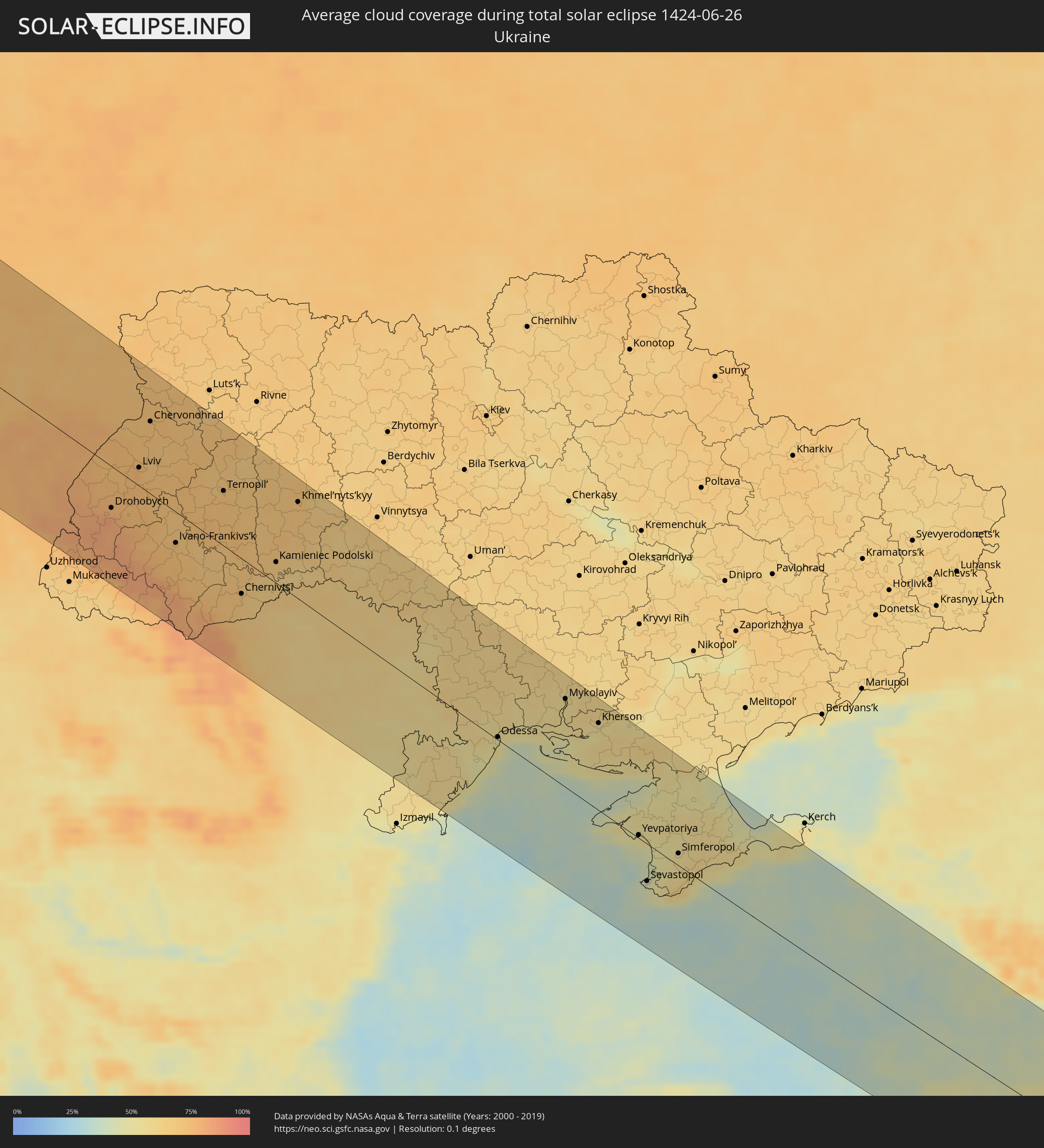 Ukraine
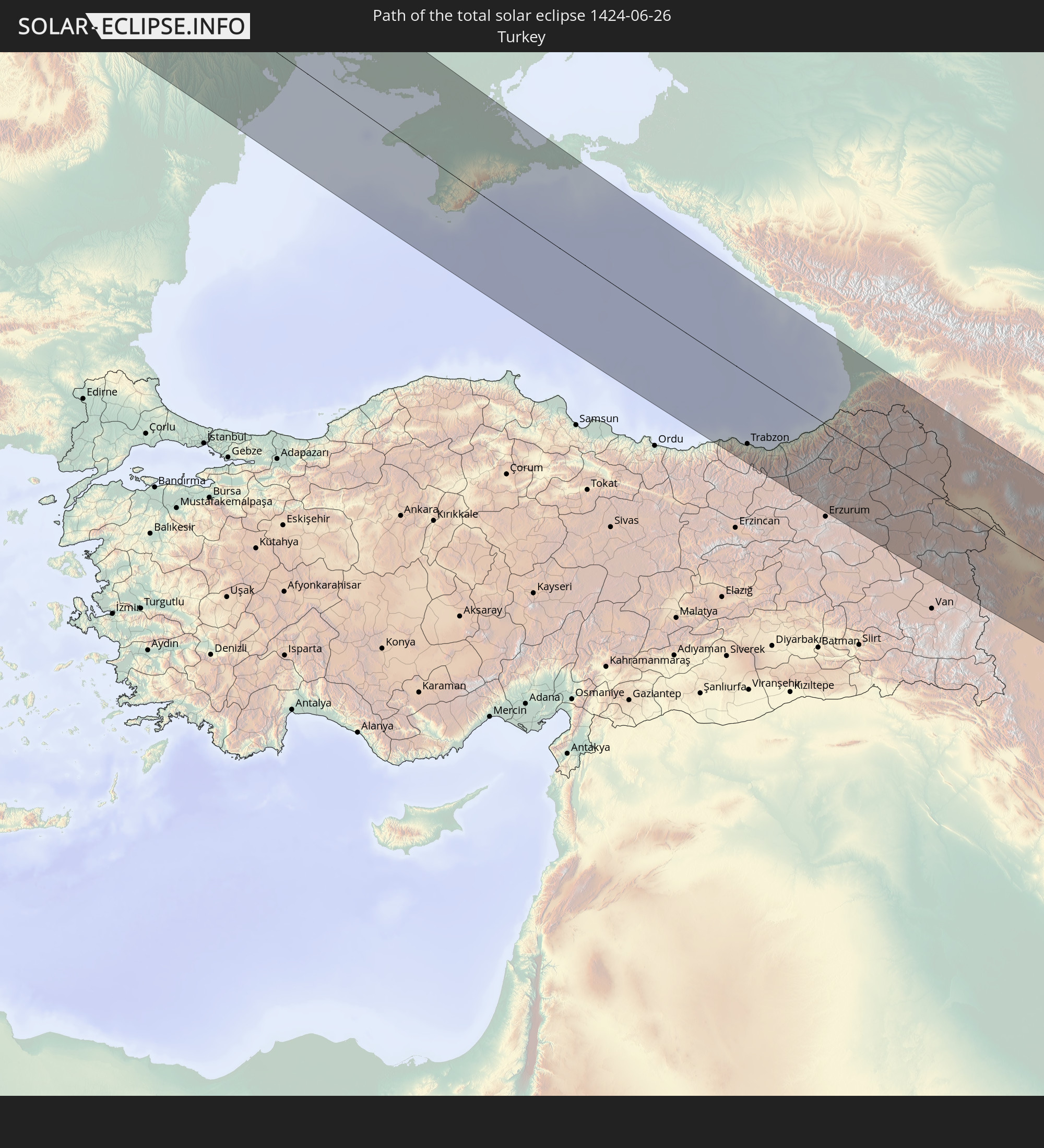
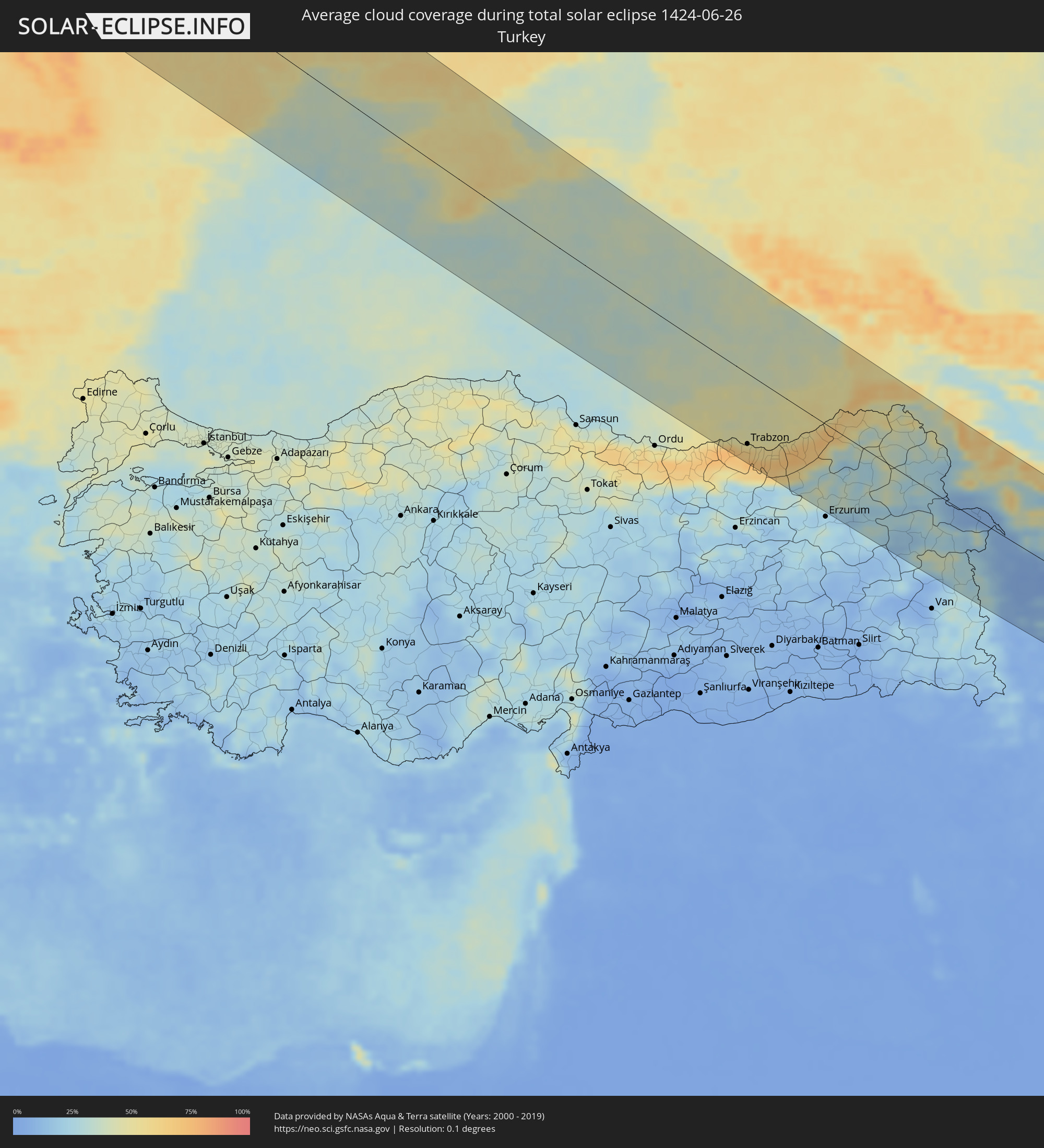 Türkei
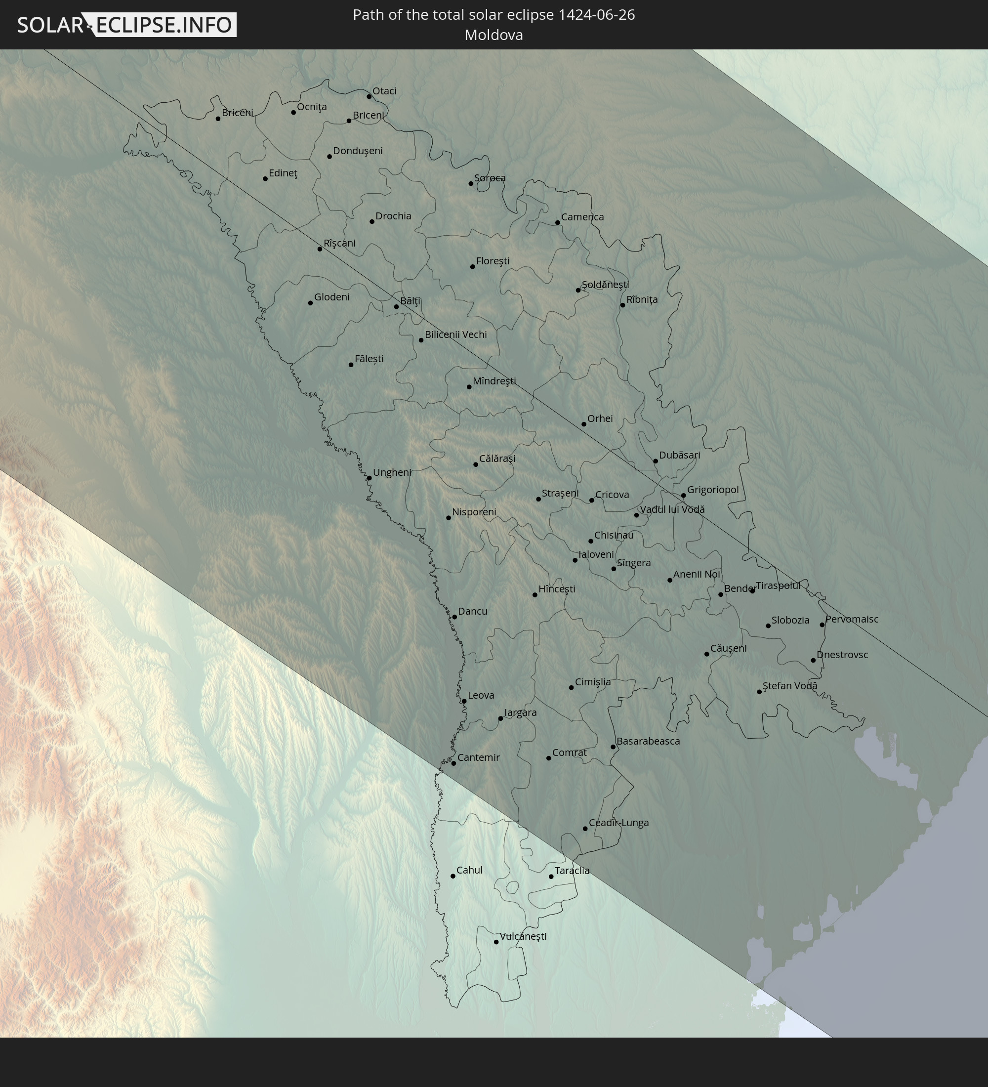
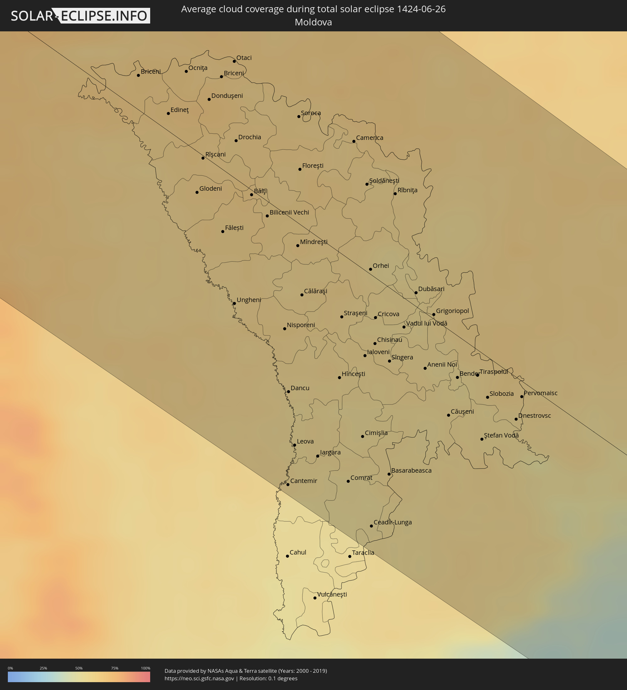 Moldawien
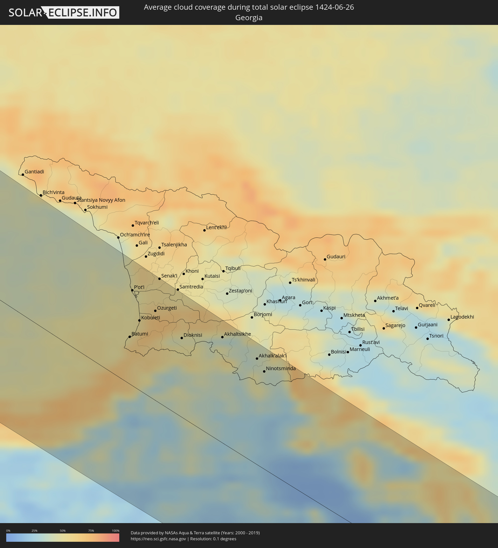 Georgien
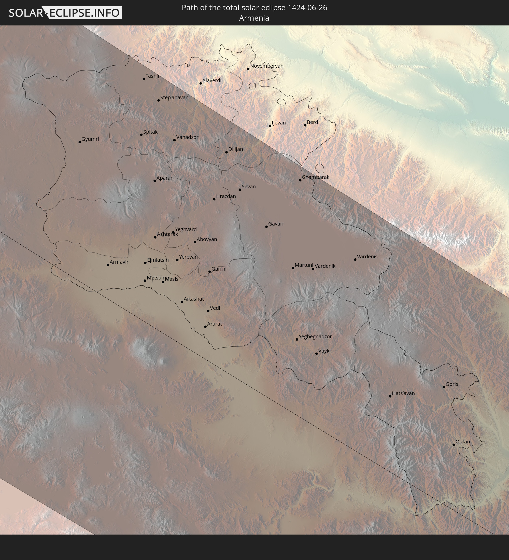
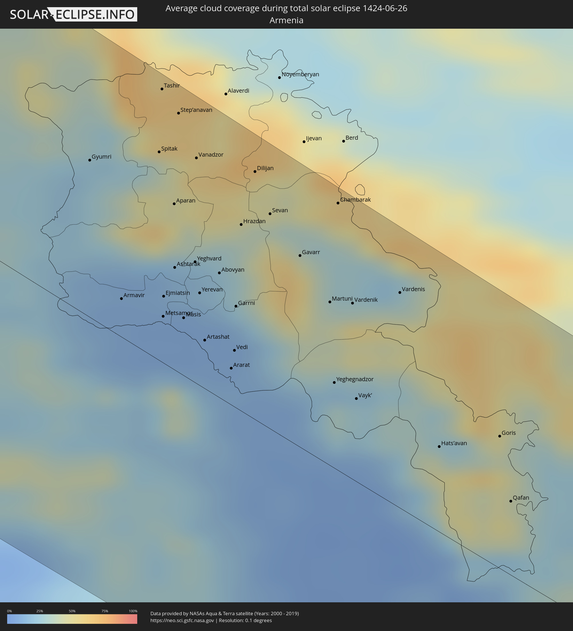 Armenien
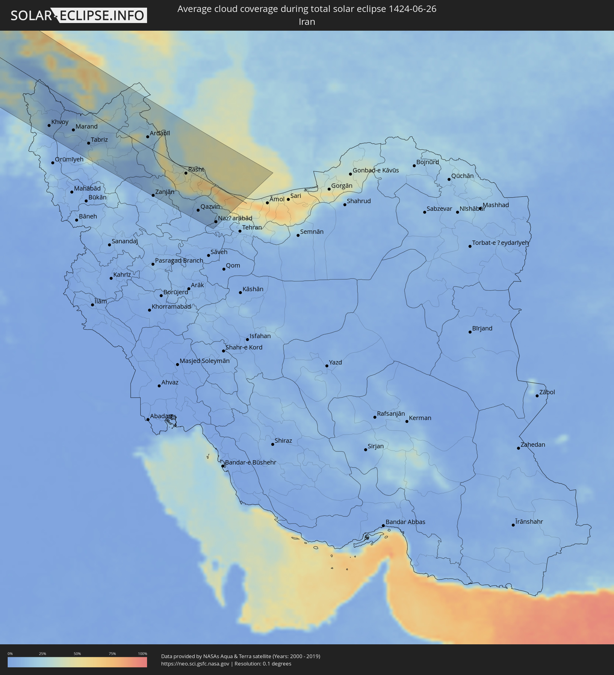 Iran
Iran
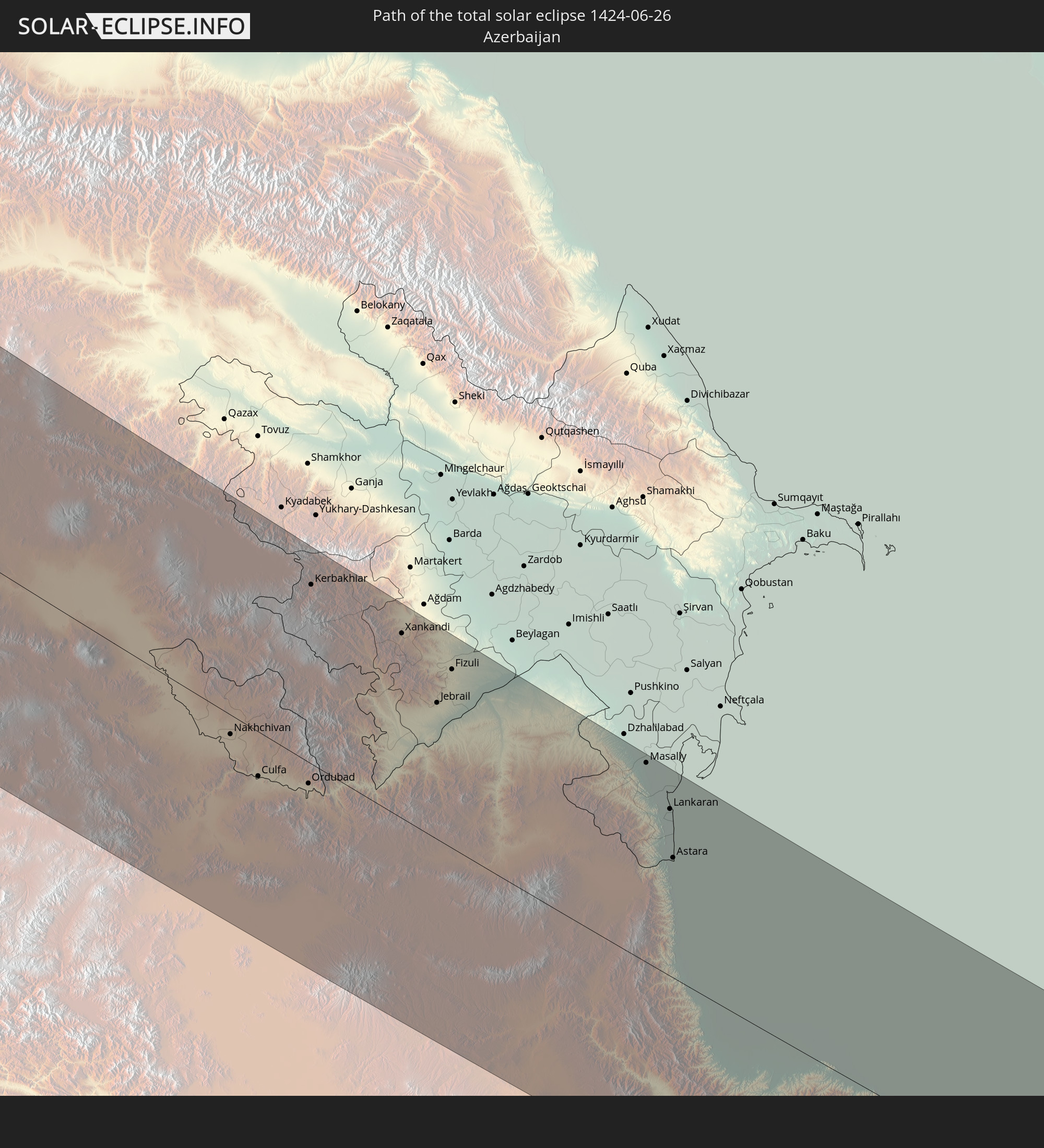
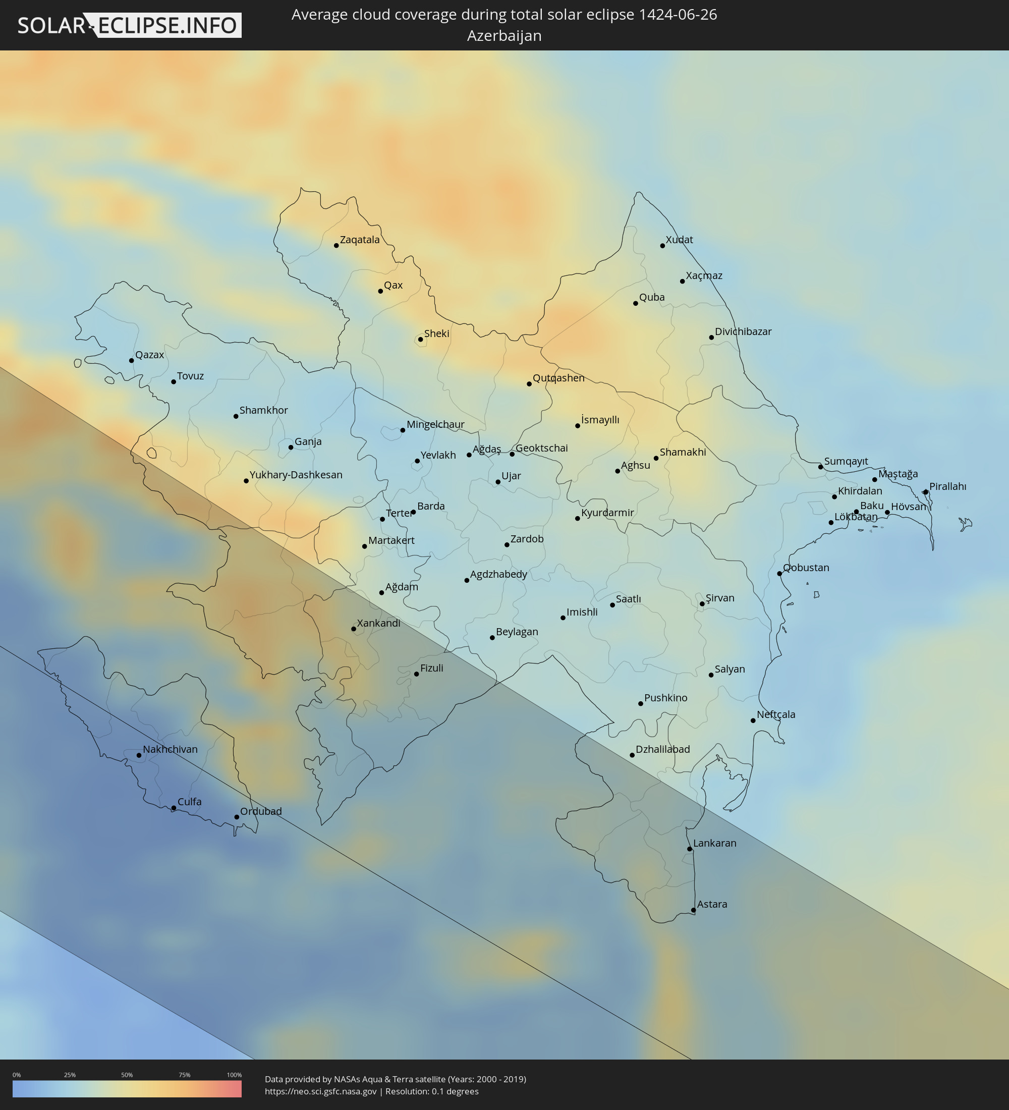 Aserbaidschan
Orte im Finsternispfad
Die nachfolgene Tabelle zeigt Städte und Orte mit mehr als 5.000 Einwohnern, die sich im Finsternispfad befinden. Städte mit mehr als 100.000 Einwohnern sind dick gekennzeichnet. Mit einem Klick auf den Ort öffnet sich eine Detailkarte die die Lage des jeweiligen Ortes zusammen mit dem Verlauf der zentralen Finsternis präsentiert.
| Ort | Typ | Dauer der Verfinsterung | Ortszeit bei maximaler Verfinsterung | Entfernung zur Zentrallinie | Ø Bewölkung |
|
Santa Rosa, California
|
total | - | 05:11:15 UTC-08:00 | 98 km | 18% |
|
San Francisco, California
|
total | - | 05:10:24 UTC-08:00 | 28 km | 38% |
|
Hayward, California
|
total | - | 05:10:09 UTC-08:00 | 13 km | 20% |
|
Concord, California
|
total | - | 05:10:28 UTC-08:00 | 24 km | 13% |
|
Fremont, California
|
total | - | 05:09:59 UTC-08:00 | 24 km | 25% |
|
San Jose, California
|
total | - | 05:09:43 UTC-08:00 | 48 km | 11% |
|
Salinas, California
|
total | - | 05:08:54 UTC-08:00 | 121 km | 29% |
|
Sacramento, California
|
total | - | 05:10:56 UTC-08:00 | 59 km | 12% |
|
Elk Grove, California
|
total | - | 05:10:41 UTC-08:00 | 38 km | 12% |
|
Stockton, California
|
total | - | 05:10:09 UTC-08:00 | 19 km | 10% |
|
Roseville, California
|
total | - | 05:11:02 UTC-08:00 | 64 km | 12% |
|
Modesto, California
|
total | - | 05:09:41 UTC-08:00 | 59 km | 12% |
|
Reno, Nevada
|
total | - | 05:11:24 UTC-08:00 | 73 km | 16% |
|
Brandon, Manitoba
|
total | - | 07:23:41 UTC-06:00 | 134 km | 60% |
|
Portage la Prairie, Manitoba
|
total | - | 07:24:11 UTC-06:00 | 77 km | 65% |
|
Morden, Manitoba
|
total | - | 07:23:00 UTC-06:00 | 12 km | 64% |
|
Winkler, Manitoba
|
total | - | 07:23:01 UTC-06:00 | 12 km | 65% |
|
Winnipeg, Manitoba
|
total | - | 07:24:17 UTC-06:00 | 19 km | 72% |
|
Selkirk, Manitoba
|
total | - | 07:24:45 UTC-06:00 | 34 km | 64% |
|
Steinbach, Manitoba
|
total | - | 07:23:50 UTC-06:00 | 33 km | 69% |
|
Thurso, Scotland
|
total | - | 15:06:19 UTC+00:00 | 82 km | 79% |
|
Wick, Scotland
|
total | - | 15:06:53 UTC+00:00 | 87 km | 79% |
|
Orkney, Scotland
|
total | - | 15:06:14 UTC+00:00 | 33 km | 80% |
|
Kirkwall, Scotland
|
total | - | 15:06:14 UTC+00:00 | 33 km | 80% |
|
Lerwick, Scotland
|
total | - | 15:05:59 UTC+00:00 | 134 km | 86% |
|
Shetland, Scotland
|
total | - | 15:05:59 UTC+00:00 | 134 km | 86% |
|
Esbjerg, South Denmark
|
total | - | 16:19:38 UTC+01:00 | 46 km | 78% |
|
Herning, Central Jutland
|
total | - | 16:18:52 UTC+01:00 | 36 km | 77% |
|
Flensburg, Schleswig-Holstein
|
total | - | 16:21:19 UTC+01:00 | 77 km | 75% |
|
Kolding, South Denmark
|
total | - | 16:20:12 UTC+01:00 | 9 km | 72% |
|
Vejle, South Denmark
|
total | - | 16:19:53 UTC+01:00 | 15 km | 71% |
|
Silkeborg, Central Jutland
|
total | - | 16:19:09 UTC+01:00 | 58 km | 75% |
|
Horsens, Central Jutland
|
total | - | 16:19:49 UTC+01:00 | 39 km | 72% |
|
Neumünster, Schleswig-Holstein
|
total | - | 16:22:46 UTC+01:00 | 125 km | 76% |
|
Randers, Central Jutland
|
total | - | 16:18:57 UTC+01:00 | 102 km | 73% |
|
Kiel, Schleswig-Holstein
|
total | - | 16:22:27 UTC+01:00 | 97 km | 73% |
|
Århus, Central Jutland
|
total | - | 16:19:32 UTC+01:00 | 79 km | 74% |
|
Odense, South Denmark
|
total | - | 16:20:52 UTC+01:00 | 21 km | 75% |
|
Lübeck, Schleswig-Holstein
|
total | - | 16:23:29 UTC+01:00 | 121 km | 74% |
|
Schwerin, Mecklenburg-Vorpommern
|
total | - | 16:24:16 UTC+01:00 | 118 km | 75% |
|
Wismar, Mecklenburg-Vorpommern
|
total | - | 16:23:52 UTC+01:00 | 93 km | 75% |
|
Næstved, Zealand
|
total | - | 16:21:52 UTC+01:00 | 45 km | 71% |
|
Roskilde, Zealand
|
total | - | 16:21:22 UTC+01:00 | 95 km | 74% |
|
Rostock, Mecklenburg-Vorpommern
|
total | - | 16:23:55 UTC+01:00 | 49 km | 77% |
|
Greve, Zealand
|
total | - | 16:21:34 UTC+01:00 | 96 km | 74% |
|
Copenhagen, Capital Region
|
total | - | 16:21:33 UTC+01:00 | 114 km | 76% |
|
Skanör med Falsterbo, Skåne
|
total | - | 16:22:08 UTC+01:00 | 98 km | 72% |
|
Bunkeflostrand, Skåne
|
total | - | 16:21:58 UTC+01:00 | 114 km | 70% |
|
Höllviken, Skåne
|
total | - | 16:22:11 UTC+01:00 | 103 km | 73% |
|
Malmö, Skåne
|
total | - | 16:21:53 UTC+01:00 | 123 km | 72% |
|
Bjärred, Skåne
|
total | - | 16:21:42 UTC+01:00 | 134 km | 74% |
|
Lomma, Skåne
|
total | - | 16:21:48 UTC+01:00 | 131 km | 70% |
|
Arlöv, Skåne
|
total | - | 16:21:52 UTC+01:00 | 127 km | 72% |
|
Stralsund, Mecklenburg-Vorpommern
|
total | - | 16:24:02 UTC+01:00 | 6 km | 73% |
|
Oxie, Skåne
|
total | - | 16:22:02 UTC+01:00 | 120 km | 70% |
|
Trelleborg, Skåne
|
total | - | 16:22:20 UTC+01:00 | 108 km | 72% |
|
Staffanstorp, Skåne
|
total | - | 16:21:55 UTC+01:00 | 133 km | 71% |
|
Svedala, Skåne
|
total | - | 16:22:09 UTC+01:00 | 122 km | 70% |
|
Neubrandenburg, Mecklenburg-Vorpommern
|
total | - | 16:25:20 UTC+01:00 | 61 km | 73% |
|
Greifswald, Mecklenburg-Vorpommern
|
total | - | 16:24:32 UTC+01:00 | 7 km | 74% |
|
Skurup, Skåne
|
total | - | 16:22:20 UTC+01:00 | 128 km | 72% |
|
Eberswalde, Brandenburg
|
total | - | 16:26:47 UTC+01:00 | 107 km | 75% |
|
Ystad, Skåne
|
total | - | 16:22:34 UTC+01:00 | 135 km | 73% |
|
Schwedt (Oder), Brandenburg
|
total | - | 16:26:38 UTC+01:00 | 69 km | 76% |
|
Frankfurt (Oder), Brandenburg
|
total | - | 16:27:55 UTC+01:00 | 124 km | 73% |
|
Szczecin, West Pomeranian Voivodeship
|
total | - | 16:50:10 UTC+01:24 | 31 km | 73% |
|
Poznań, Greater Poland Voivodeship
|
total | - | 16:52:51 UTC+01:24 | 29 km | 76% |
|
Bydgoszcz, Kujawsko-Pomorskie
|
total | - | 16:52:06 UTC+01:24 | 79 km | 75% |
|
Toruń, Kujawsko-Pomorskie
|
total | - | 16:52:30 UTC+01:24 | 92 km | 76% |
|
Częstochowa, Silesian Voivodeship
|
total | - | 16:56:16 UTC+01:24 | 92 km | 78% |
|
Dąbrowa Górnicza, Silesian Voivodeship
|
total | - | 16:57:04 UTC+01:24 | 132 km | 77% |
|
Łódź, Łódź Voivodeship
|
total | - | 16:54:51 UTC+01:24 | 13 km | 74% |
|
Kraków, Lesser Poland Voivodeship
|
total | - | 16:57:43 UTC+01:24 | 127 km | 77% |
|
Kielce, Świętokrzyskie
|
total | - | 16:56:38 UTC+01:24 | 29 km | 75% |
|
Warsaw, Masovian Voivodeship
|
total | - | 16:54:34 UTC+01:24 | 114 km | 76% |
|
Radom, Masovian Voivodeship
|
total | - | 16:55:57 UTC+01:24 | 48 km | 72% |
|
Svidník, Prešovský
|
total | - | 16:35:24 UTC+01:00 | 130 km | 72% |
|
Medzilaborce, Prešovský
|
total | - | 16:35:33 UTC+01:00 | 120 km | 75% |
|
Rzeszów, Subcarpathian Voivodeship
|
total | - | 16:58:22 UTC+01:24 | 47 km | 77% |
|
Lublin, Lublin Voivodeship
|
total | - | 16:56:35 UTC+01:24 | 89 km | 74% |
|
Lviv, Lviv
|
total | - | 17:37:15 UTC+02:02 | 24 km | 75% |
|
Chervonohrad, Lviv
|
total | - | 17:36:25 UTC+02:02 | 79 km | 71% |
|
Ivano-Frankivs’k, Ivano-Frankivsk
|
total | - | 17:38:50 UTC+02:02 | 34 km | 72% |
|
Câmpulung Moldovenesc, Suceava
|
total | - | 17:23:28 UTC+01:44 | 125 km | 81% |
|
Ternopil’, Ternopil
|
total | - | 17:38:01 UTC+02:02 | 62 km | 71% |
|
Gura Humorului, Suceava
|
total | - | 17:23:30 UTC+01:44 | 111 km | 74% |
|
Rădăuți, Suceava
|
total | - | 17:23:03 UTC+01:44 | 81 km | 71% |
|
Chernivtsi, Chernivtsi
|
total | - | 17:40:02 UTC+02:02 | 46 km | 69% |
|
Suceava, Suceava
|
total | - | 17:23:26 UTC+01:44 | 87 km | 64% |
|
Fălticeni, Suceava
|
total | - | 17:23:43 UTC+01:44 | 101 km | 63% |
|
Târgu Neamţ, Neamţ
|
total | - | 17:24:07 UTC+01:44 | 123 km | 64% |
|
Dorohoi, Botoşani
|
total | - | 17:22:58 UTC+01:44 | 54 km | 64% |
|
Kamieniec Podolski, Khmelnytskyi
|
total | - | 17:39:32 UTC+02:02 | 25 km | 67% |
|
Botoşani, Botoşani
|
total | - | 17:23:19 UTC+01:44 | 59 km | 60% |
|
Paşcani, Iaşi
|
total | - | 17:24:06 UTC+01:44 | 101 km | 62% |
|
Roman, Neamţ
|
total | - | 17:24:37 UTC+01:44 | 123 km | 60% |
|
Khmel’nyts’kyy, Khmelnytskyi
|
total | - | 17:38:27 UTC+02:02 | 108 km | 69% |
|
Edineţ, Raionul Edineţ
|
total | - | 17:33:22 UTC+01:55 | 23 km | 62% |
|
Iaşi, Iaşi
|
total | - | 17:24:20 UTC+01:44 | 72 km | 62% |
|
Vaslui, Vaslui
|
total | - | 17:25:09 UTC+01:44 | 114 km | 58% |
|
Ungheni, Ungheni
|
total | - | 17:34:53 UTC+01:55 | 62 km | 60% |
|
Bălţi, Bălţi
|
total | - | 17:34:04 UTC+01:55 | 5 km | 62% |
|
Huşi, Vaslui
|
total | - | 17:25:08 UTC+01:44 | 98 km | 56% |
|
Soroca, Raionul Soroca
|
total | - | 17:33:30 UTC+01:55 | 50 km | 61% |
|
Straşeni, Strășeni
|
total | - | 17:35:05 UTC+01:55 | 33 km | 57% |
|
Comrat, Găgăuzia
|
total | - | 17:36:21 UTC+01:55 | 105 km | 54% |
|
Orhei, Orhei
|
total | - | 17:34:44 UTC+01:55 | 18 km | 58% |
|
Ceadîr-Lunga, Găgăuzia
|
total | - | 17:36:43 UTC+01:55 | 120 km | 53% |
|
Chisinau, Chişinău
|
total | - | 17:35:18 UTC+01:55 | 32 km | 58% |
|
Rîbniţa, Stînga Nistrului
|
total | - | 17:34:10 UTC+01:55 | 47 km | 59% |
|
Dubăsari, Teleneşti
|
total | - | 17:34:57 UTC+01:55 | 13 km | 56% |
|
Căuşeni, Căuşeni
|
total | - | 17:35:54 UTC+01:55 | 45 km | 57% |
|
Tiraspolul, Stînga Nistrului
|
total | - | 17:35:37 UTC+01:55 | 24 km | 56% |
|
Odessa, Odessa
|
total | - | 17:43:17 UTC+02:02 | 20 km | 52% |
|
Mykolayiv, Mykolaiv
|
total | - | 17:42:36 UTC+02:02 | 105 km | 54% |
|
Kherson, Kherson
|
total | - | 17:43:04 UTC+02:02 | 104 km | 55% |
|
Yevpatoriya, Republic of Crimea
|
total | - | 17:59:06 UTC+02:16 | 16 km | 49% |
|
Sevastopol, Gorod Sevastopol
|
total | - | 17:59:58 UTC+02:16 | 48 km | 43% |
|
Simferopol, Republic of Crimea
|
total | - | 17:59:25 UTC+02:16 | 15 km | 54% |
|
Vakfıkebir, Trabzon
|
total | - | 17:45:01 UTC+01:56 | 114 km | 74% |
|
Trabzon, Trabzon
|
total | - | 17:44:59 UTC+01:56 | 99 km | 64% |
|
Araklı, Trabzon
|
total | - | 17:45:00 UTC+01:56 | 90 km | 67% |
|
Of, Trabzon
|
total | - | 17:44:57 UTC+01:56 | 83 km | 68% |
|
Rize, Rize
|
total | - | 17:44:47 UTC+01:56 | 61 km | 68% |
|
Çayeli, Rize
|
total | - | 17:44:40 UTC+01:56 | 45 km | 63% |
|
Ardeşen, Rize
|
total | - | 17:44:28 UTC+01:56 | 27 km | 64% |
|
Batumi, Ajaria
|
total | - | 18:46:00 UTC+02:59 | 51 km | 61% |
|
P’ot’i, Samegrelo and Zemo Svaneti
|
total | - | 18:45:21 UTC+02:59 | 97 km | 49% |
|
Chakvi, Ajaria
|
total | - | 18:45:53 UTC+02:59 | 62 km | 60% |
|
Kobuleti, Ajaria
|
total | - | 18:45:45 UTC+02:59 | 73 km | 64% |
|
Khobi, Samegrelo and Zemo Svaneti
|
total | - | 18:45:05 UTC+02:59 | 123 km | 54% |
|
Ozurgeti, Guria
|
total | - | 18:45:34 UTC+02:59 | 92 km | 69% |
|
Senak’i, Samegrelo and Zemo Svaneti
|
total | - | 18:45:07 UTC+02:59 | 128 km | 56% |
|
Dioknisi, Ajaria
|
total | - | 18:45:51 UTC+02:59 | 82 km | 50% |
|
Akhaltsikhe, Samtskhe-Javakheti
|
total | - | 18:45:41 UTC+02:59 | 111 km | 45% |
|
Ağrı, Ağrı
|
total | - | 17:45:46 UTC+01:56 | 69 km | 18% |
|
Kars, Kars
|
total | - | 17:44:42 UTC+01:56 | 16 km | 27% |
|
Kağızman, Kars
|
total | - | 17:45:13 UTC+01:56 | 32 km | 17% |
|
Erciş, Van
|
total | - | 17:46:31 UTC+01:56 | 121 km | 7% |
|
Akhalk’alak’i
|
total | - | 18:45:51 UTC+02:59 | 112 km | 39% |
|
Ninotsminda, Samtskhe-Javakheti
|
total | - | 18:45:59 UTC+02:59 | 101 km | 38% |
|
Gyumri, Shirak Province
|
total | - | 18:45:19 UTC+02:58 | 69 km | 22% |
|
Armavir, Armavir Province
|
total | - | 18:46:02 UTC+02:58 | 18 km | 9% |
|
Iğdır, Iğdır
|
total | - | 17:45:15 UTC+01:56 | 9 km | 15% |
|
Doğubayazıt, Ağrı
|
total | - | 17:45:41 UTC+01:56 | 43 km | 23% |
|
Ejmiatsin, Armavir Province
|
total | - | 18:45:57 UTC+02:58 | 31 km | 9% |
|
Step’anavan, Lori Province
|
total | - | 18:44:54 UTC+02:58 | 114 km | 60% |
|
Masis, Ararat Province
|
total | - | 18:46:02 UTC+02:58 | 35 km | 7% |
|
Vanadzor, Lori Province
|
total | - | 18:45:07 UTC+02:58 | 99 km | 59% |
|
Yerevan, Yerevan
|
total | - | 18:45:52 UTC+02:58 | 47 km | 12% |
|
Artashat, Ararat Province
|
total | - | 18:46:07 UTC+02:58 | 23 km | 8% |
|
Ararat, Ararat Province
|
total | - | 18:46:13 UTC+02:58 | 19 km | 11% |
|
Hrazdan, Kotayk Province
|
total | - | 18:45:24 UTC+02:58 | 85 km | 39% |
|
Khvoy, Āz̄ārbāyjān-e Gharbī
|
total | - | 19:15:23 UTC+03:25 | 95 km | 9% |
|
Sharur City, Nakhichevan
|
total | - | 19:07:52 UTC+03:19 | 4 km | 9% |
|
Gavarr, Gegharkunik Province
|
total | - | 18:45:28 UTC+02:58 | 85 km | 42% |
|
Nakhchivan, Nakhichevan
|
total | - | 19:08:08 UTC+03:19 | 11 km | 5% |
|
Cahri, Nakhichevan
|
total | - | 19:07:58 UTC+03:19 | 10 km | 6% |
|
Culfa, Nakhichevan
|
total | - | 19:08:21 UTC+03:19 | 34 km | 3% |
|
Marand, East Azerbaijan
|
total | - | 19:15:15 UTC+03:25 | 71 km | 18% |
|
Ordubad, Nakhichevan
|
total | - | 19:08:17 UTC+03:19 | 16 km | 6% |
|
Kerbakhiar, Kalbajar
|
total | - | 19:06:52 UTC+03:19 | 103 km | 61% |
|
Tabriz, East Azerbaijan
|
total | - | 19:15:28 UTC+03:25 | 83 km | 13% |
|
Goris, Syunik Province
|
total | - | 18:46:04 UTC+02:58 | 59 km | 40% |
|
Qafan, Syunik Province
|
total | - | 18:46:24 UTC+02:58 | 39 km | 44% |
|
Zangilan, Zǝngilan
|
total | - | 19:07:51 UTC+03:19 | 33 km | 23% |
|
Xankandi, Xankǝndi
|
total | - | 19:06:58 UTC+03:19 | 107 km | 47% |
|
Jebrail, Jabrayil
|
total | - | 19:07:22 UTC+03:19 | 79 km | 23% |
|
Ahar, East Azerbaijan
|
total | - | 19:14:44 UTC+03:25 | 13 km | 17% |
|
Fizuli, Füzuli
|
total | - | 19:07:05 UTC+03:19 | 104 km | 33% |
|
Ardabīl, Ardabīl
|
total | - | 19:14:32 UTC+03:25 | 30 km | 18% |
|
Zanjān, Zanjan
|
total | - | 19:16:11 UTC+03:25 | 119 km | 11% |
|
Prishibinskoye, Jalilabad
|
total | - | 19:07:07 UTC+03:19 | 123 km | 32% |
|
Lankaran, Lənkəran
|
total | - | 19:07:25 UTC+03:19 | 99 km | 27% |
|
Astara, Astara
|
total | - | 19:07:44 UTC+03:19 | 71 km | 27% |
|
Bandar-e Anzalī, Gīlān
|
total | - | 19:14:55 UTC+03:25 | 6 km | 35% |
|
Rasht, Gīlān
|
total | - | 19:15:04 UTC+03:25 | 19 km | 47% |
|
Qazvin, Qazvīn
|
total | - | 19:15:58 UTC+03:25 | 91 km | 11% |
|
Langarūd, Gīlān
|
total | - | 19:14:55 UTC+03:25 | 14 km | 47% |
|
Ābyek, Markazi
|
total | - | 19:15:56 UTC+03:25 | 86 km | 11% |
|
Naz̧arābād, Alborz
|
total | - | 19:16:02 UTC+03:25 | 96 km | 10% |
|
Chālūs, Māzandarān
|
total | - | 19:14:56 UTC+03:25 | 16 km | 55% |