Total solar eclipse of 06/26/1424
| Day of week: | Saturday |
| Maximum duration of eclipse: | 04m14s |
| Maximum width of eclipse path: | 270 km |
| Saros cycle: | 127 |
| Coverage: | 100% |
| Magnitude: | 1.0629 |
| Gamma: | 0.6425 |
Wo kann man die Sonnenfinsternis vom 06/26/1424 sehen?
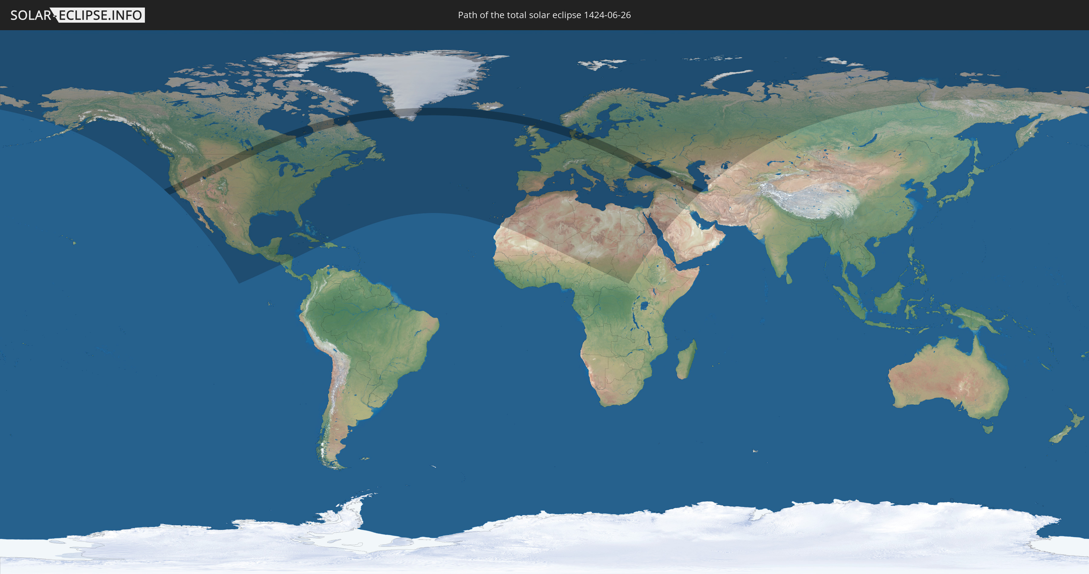
Die Sonnenfinsternis am 06/26/1424 kann man in 99 Ländern als partielle Sonnenfinsternis beobachten.
Der Finsternispfad verläuft durch 19 Länder. Nur in diesen Ländern ist sie als total Sonnenfinsternis zu sehen.
In den folgenden Ländern ist die Sonnenfinsternis total zu sehen
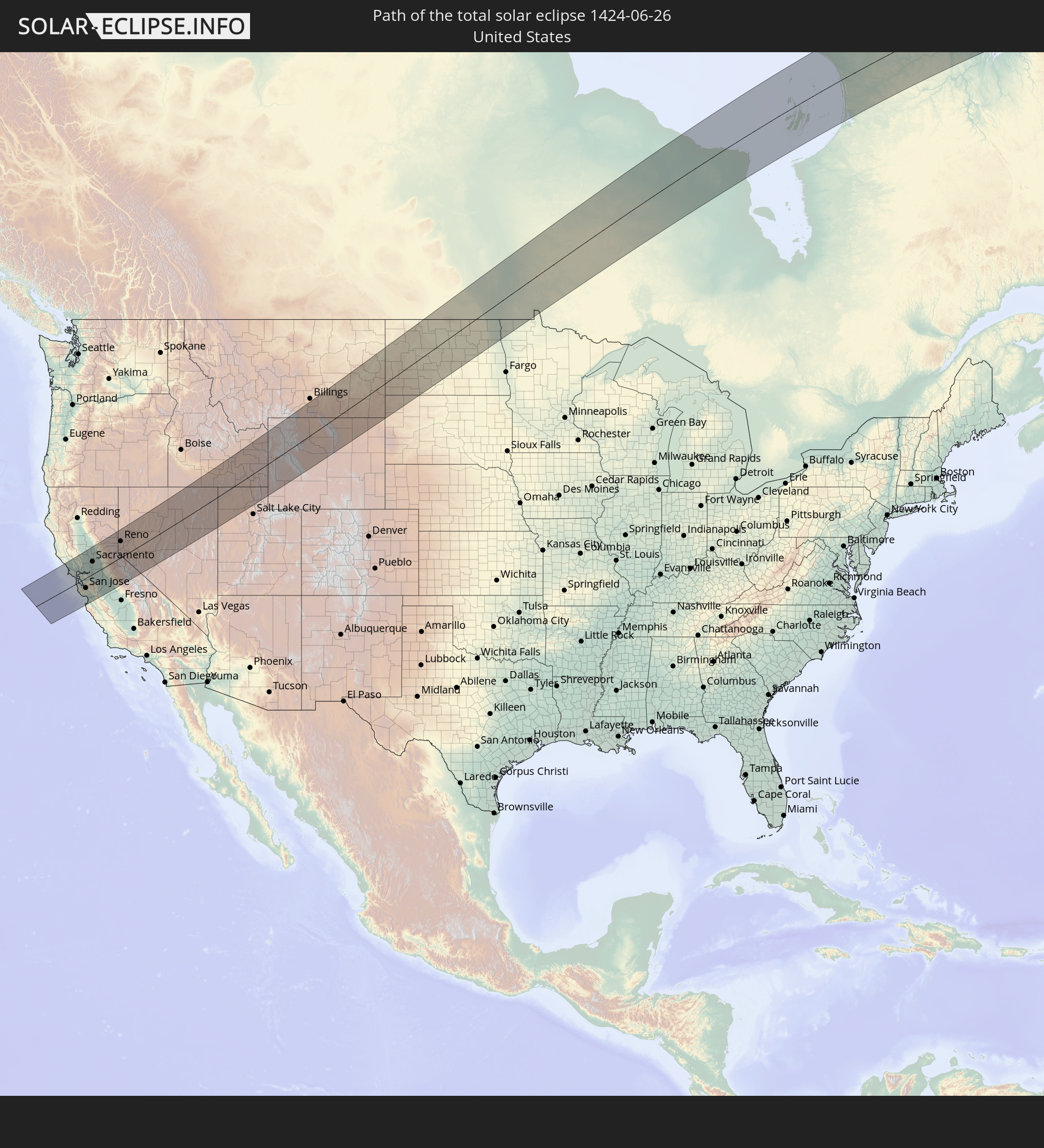 United States
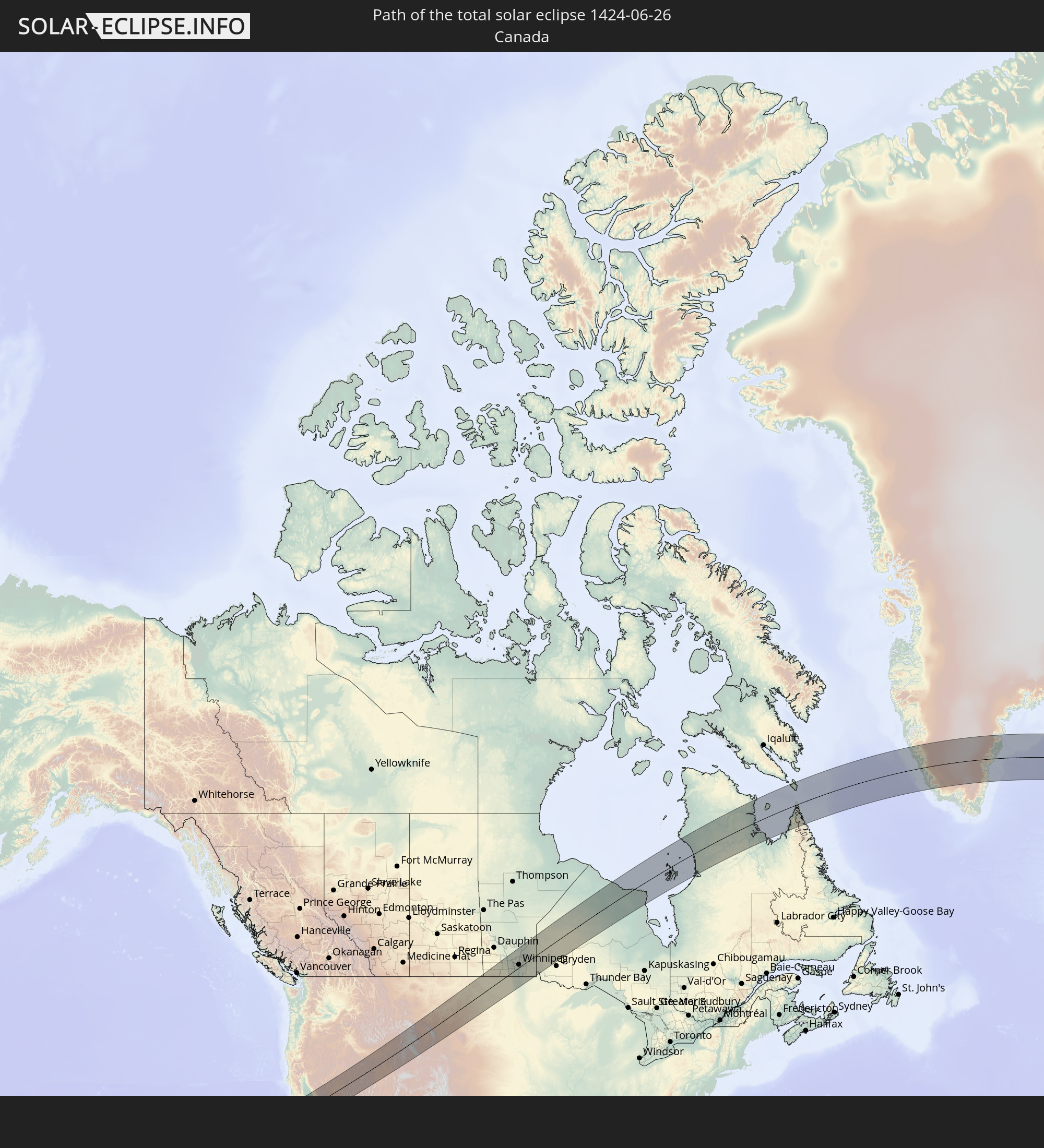 Canada
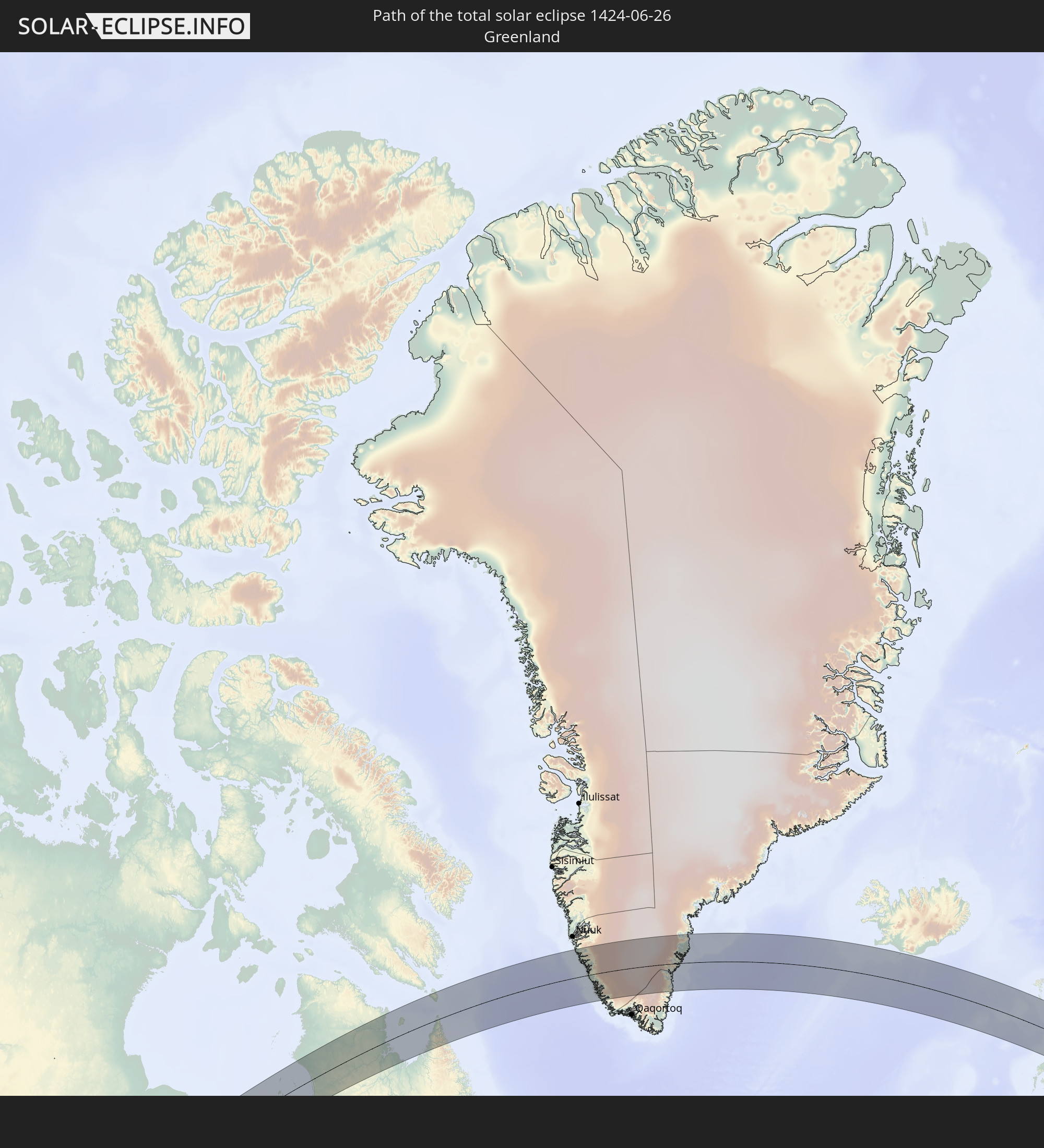 Greenland
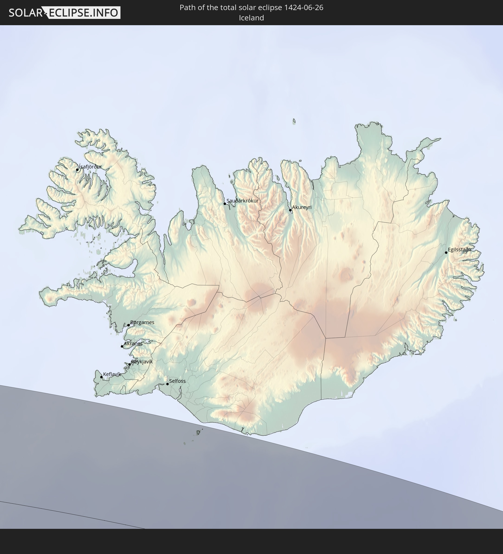 Iceland
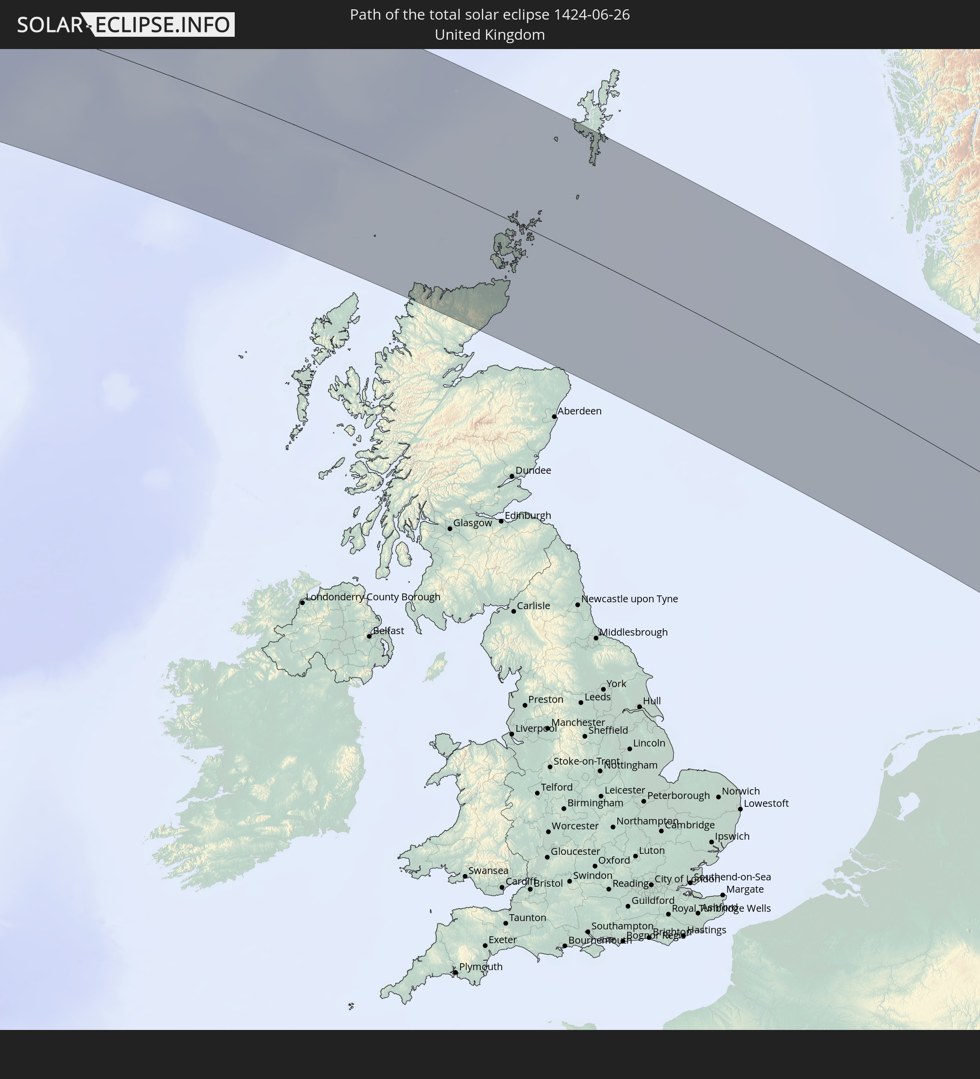 United Kingdom
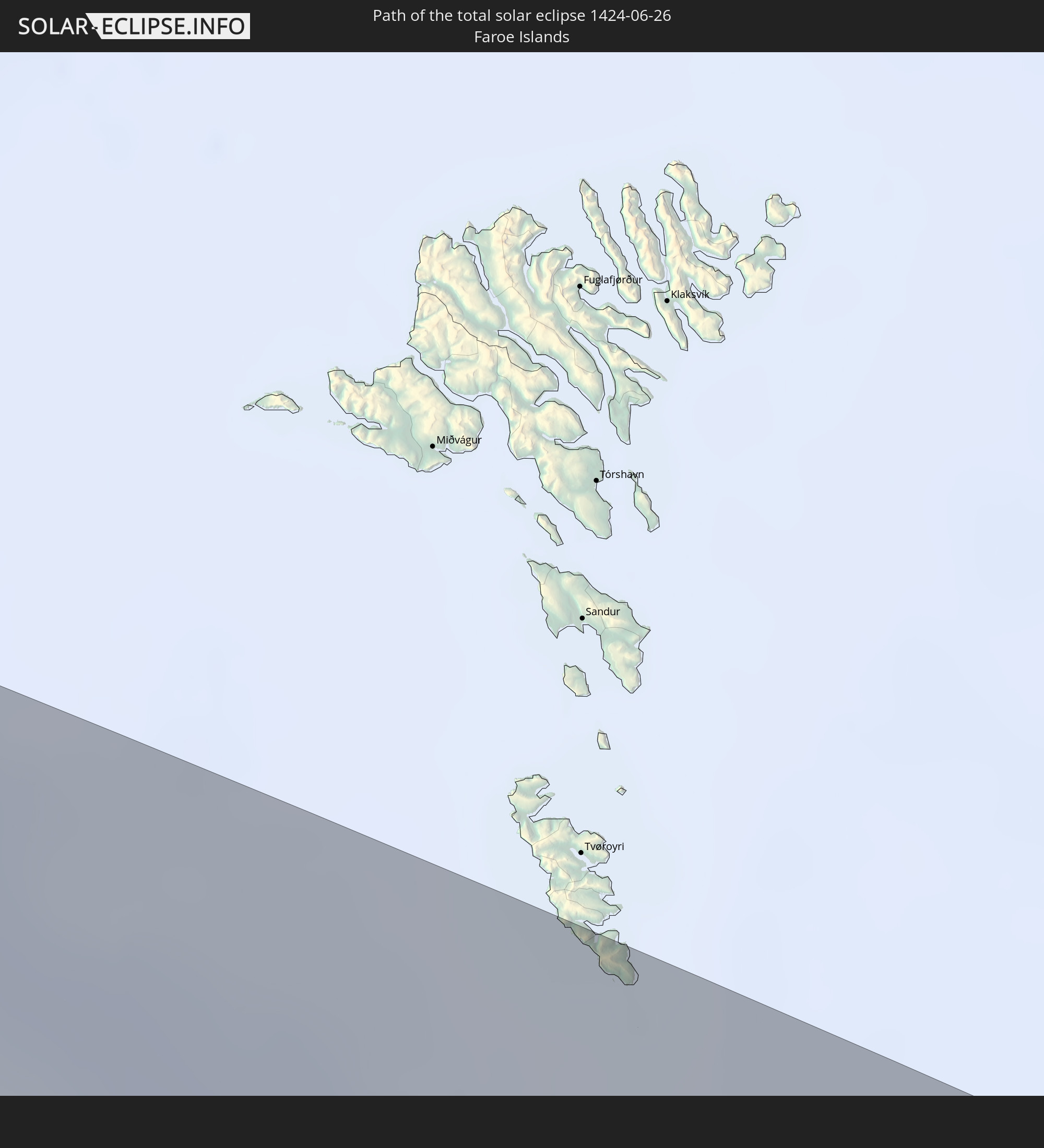 Faroe Islands
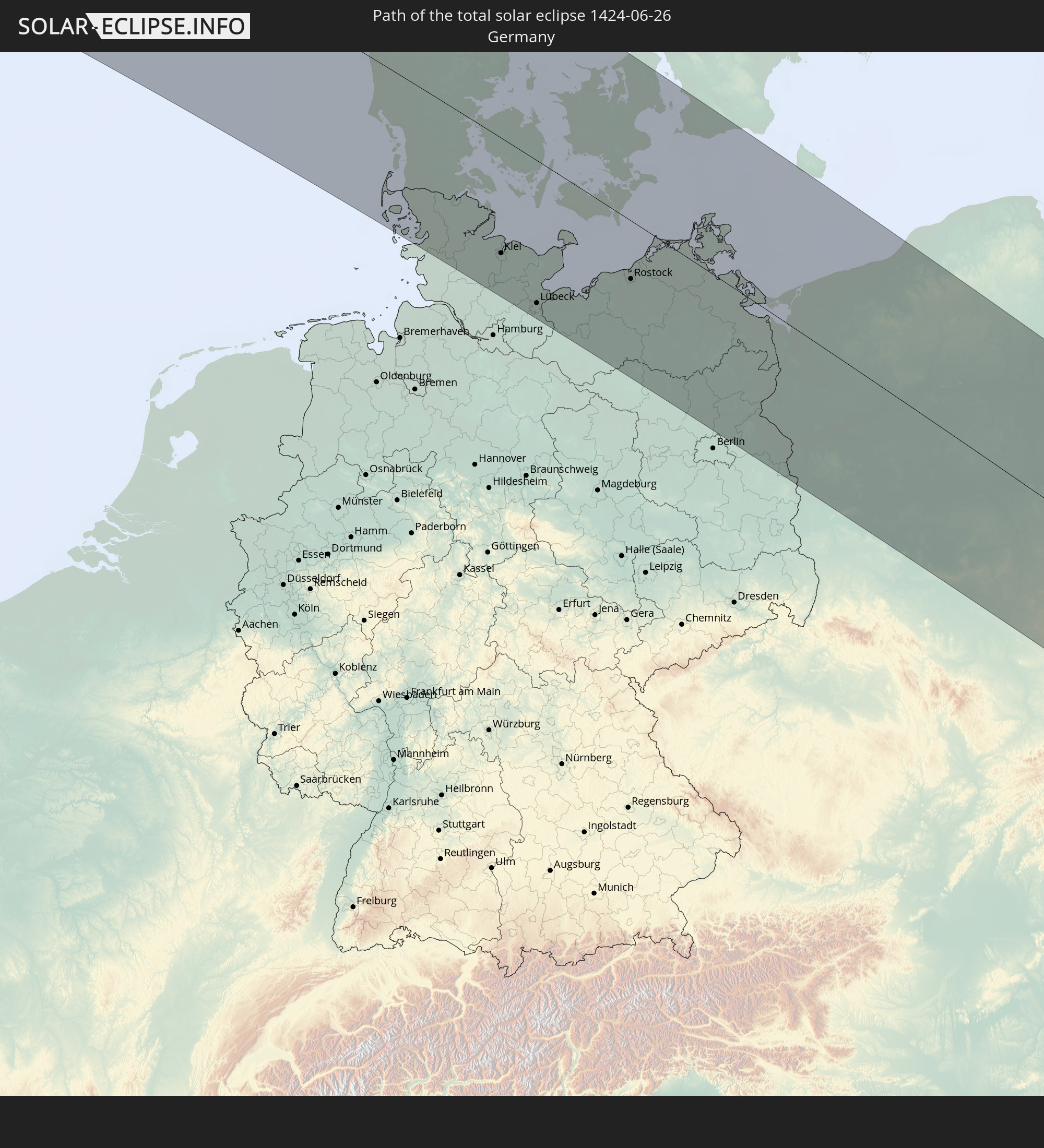 Germany
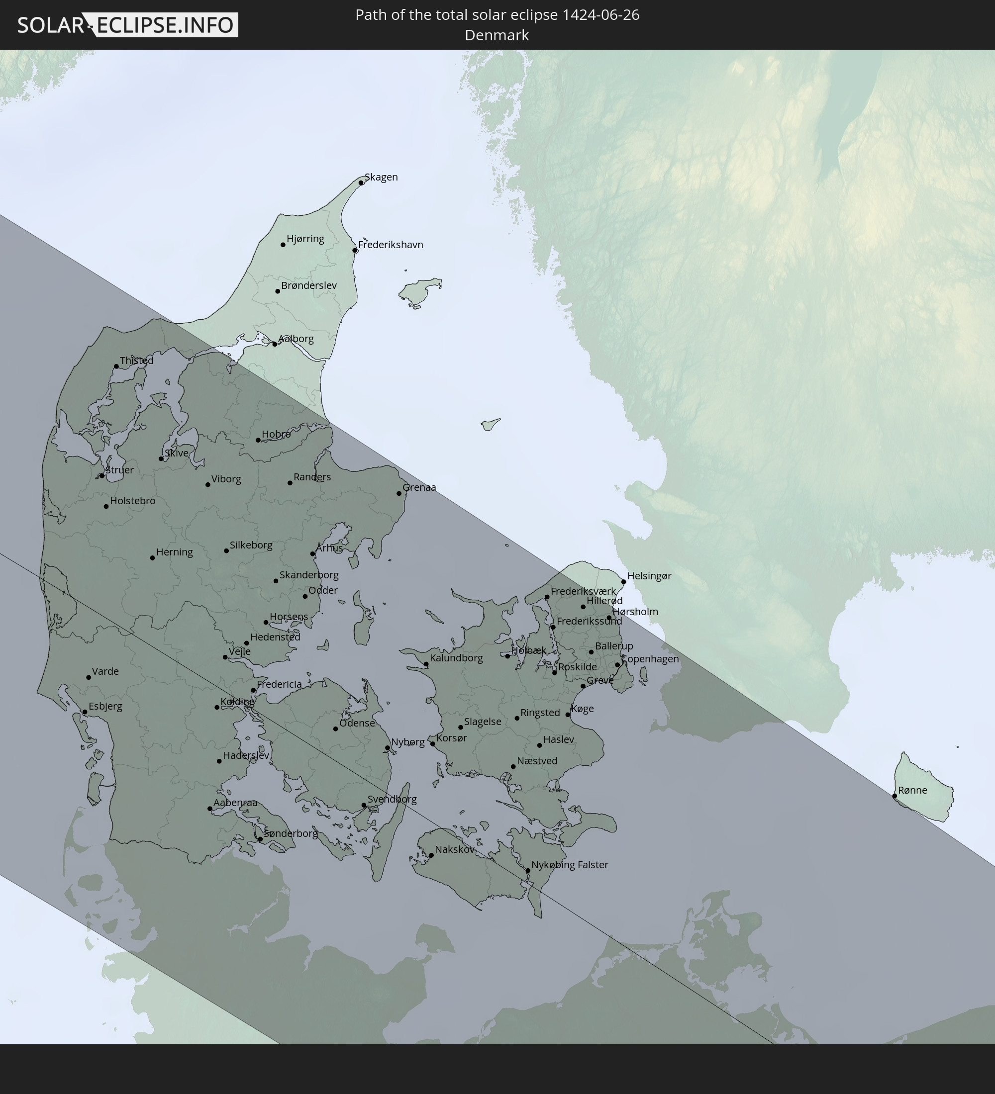 Denmark
 Sweden
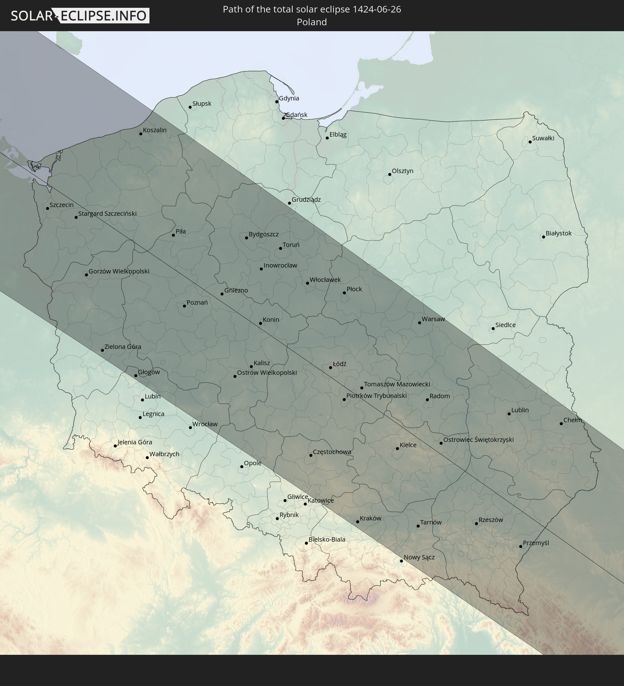 Poland
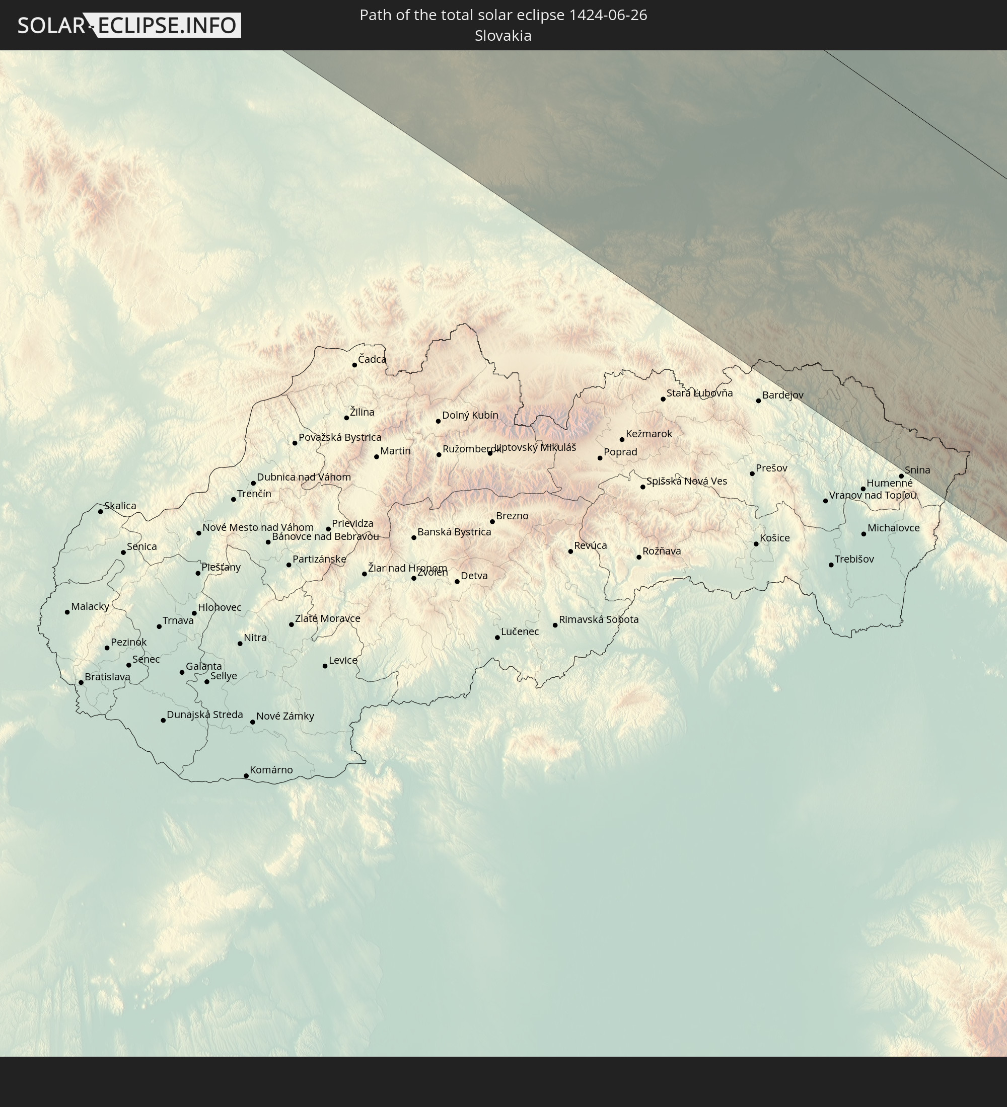 Slovakia
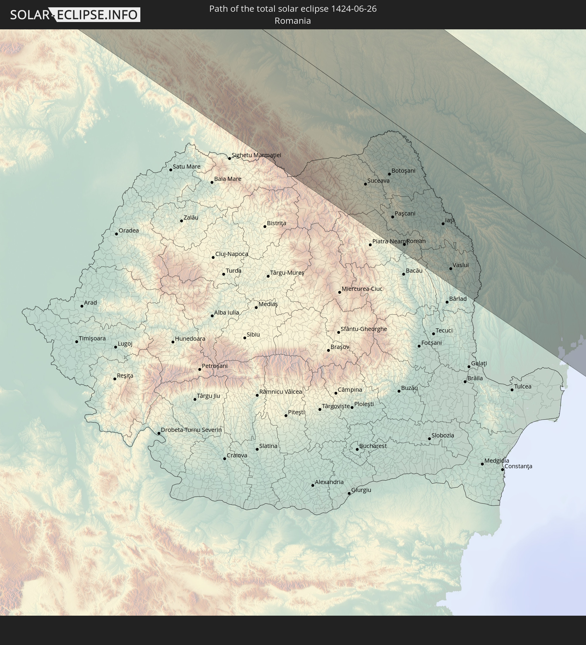 Romania
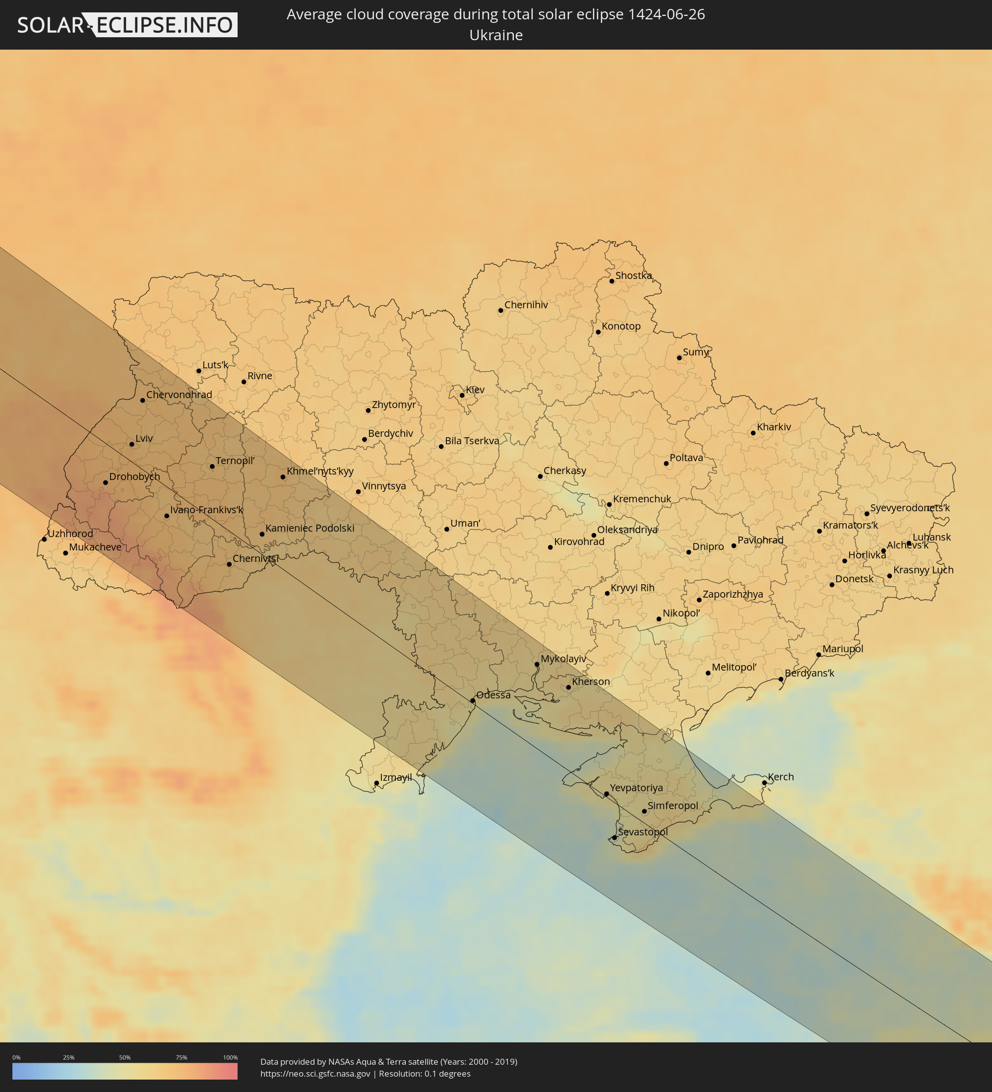
 Ukraine
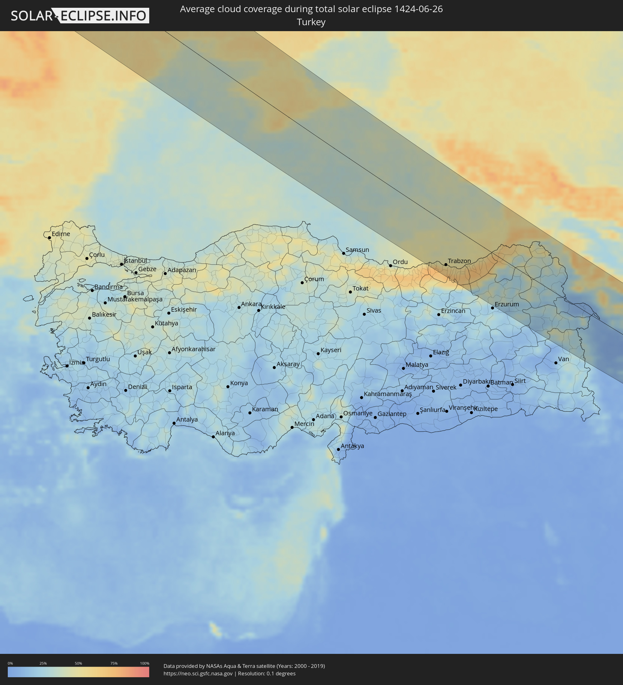
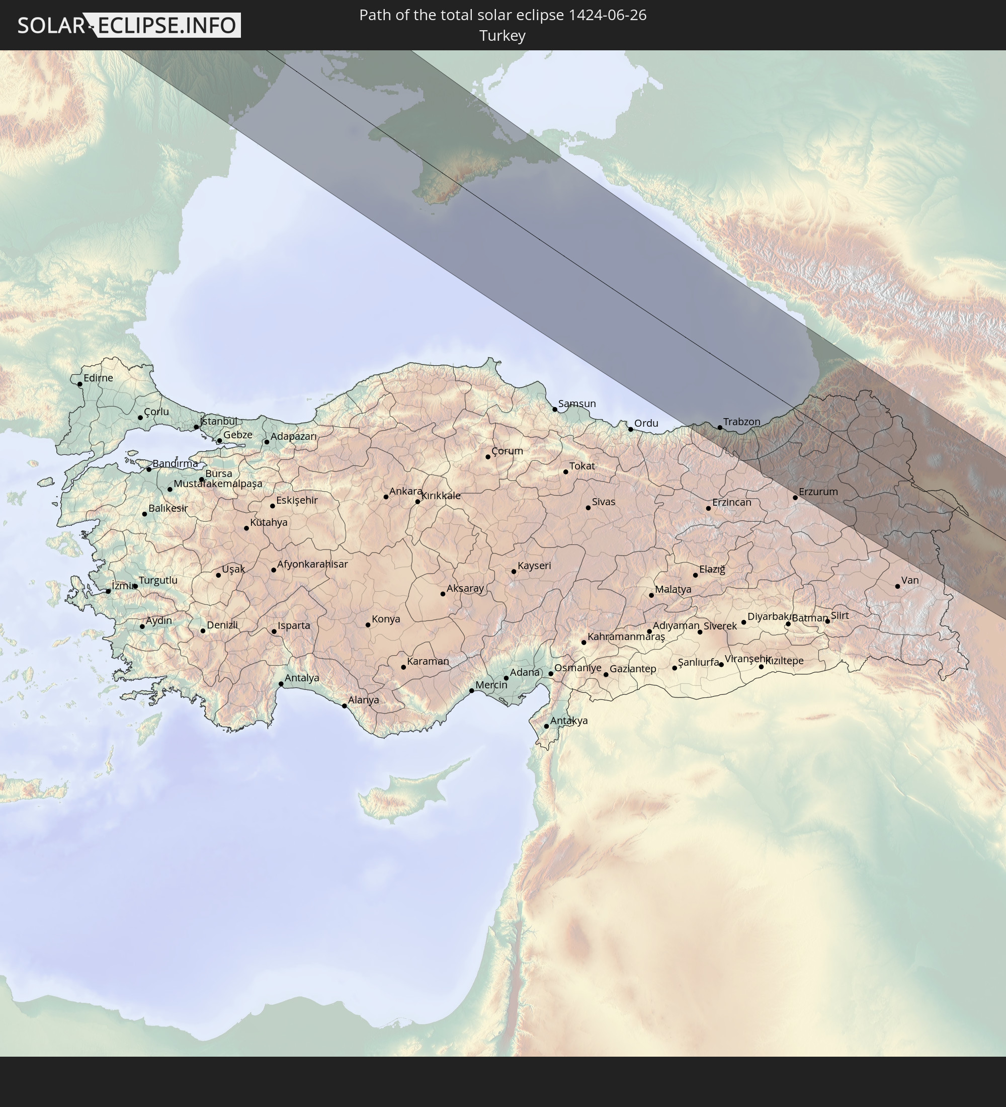 Turkey
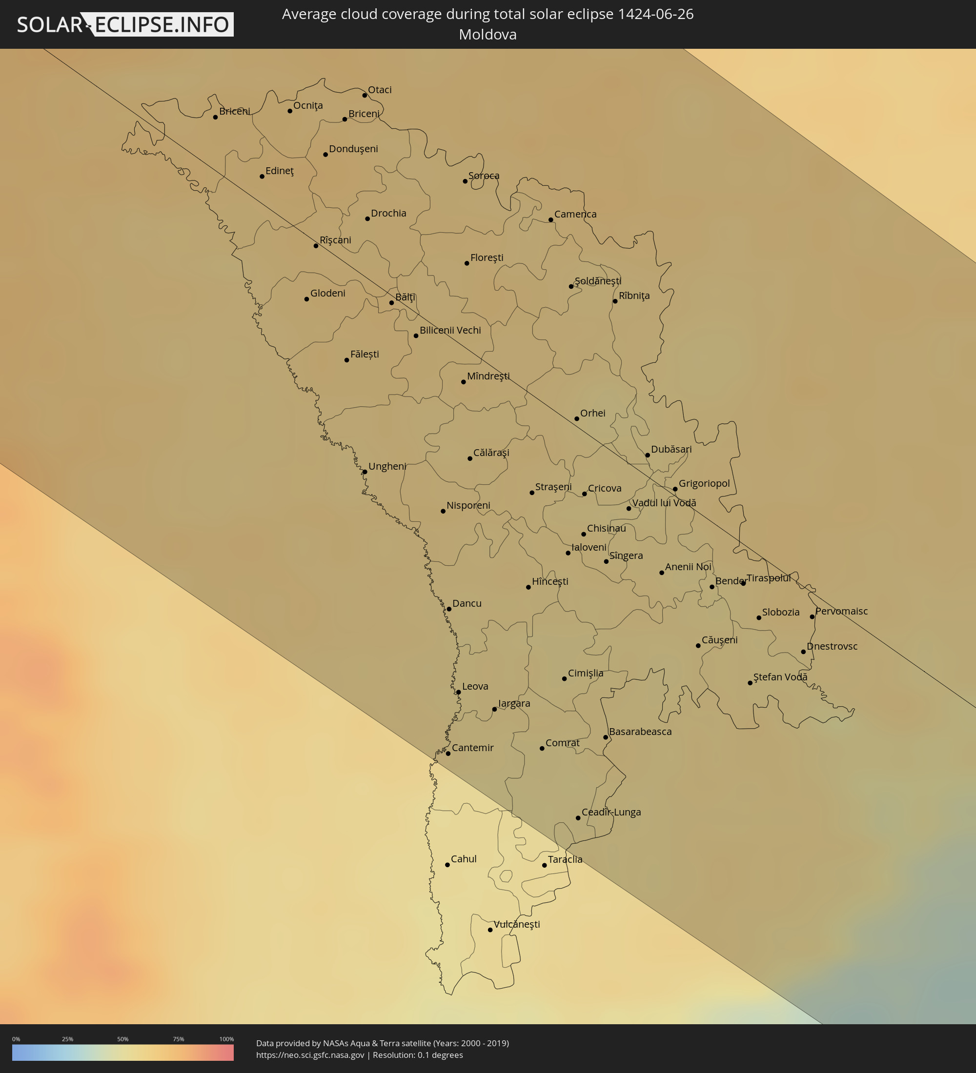
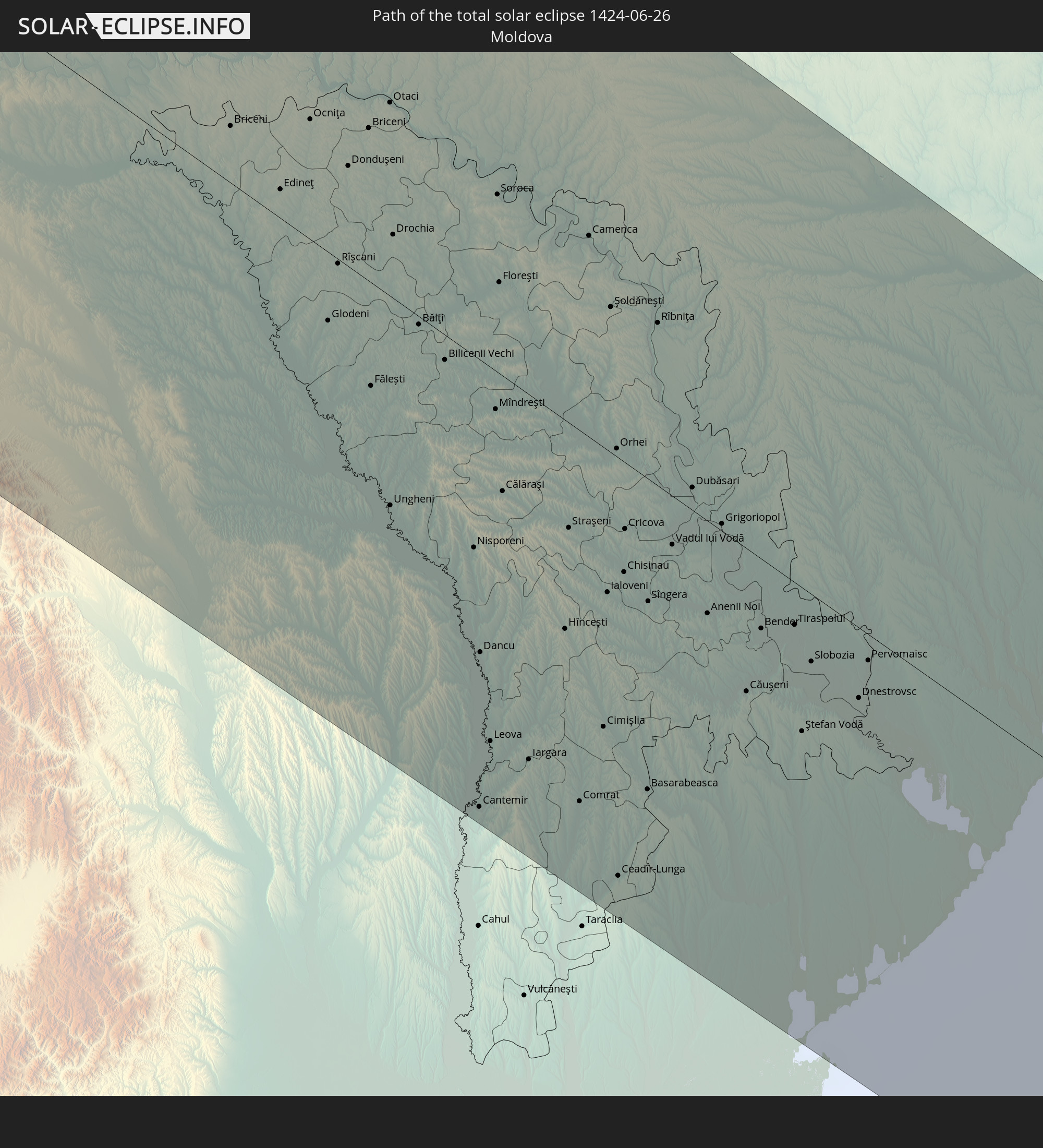 Moldova
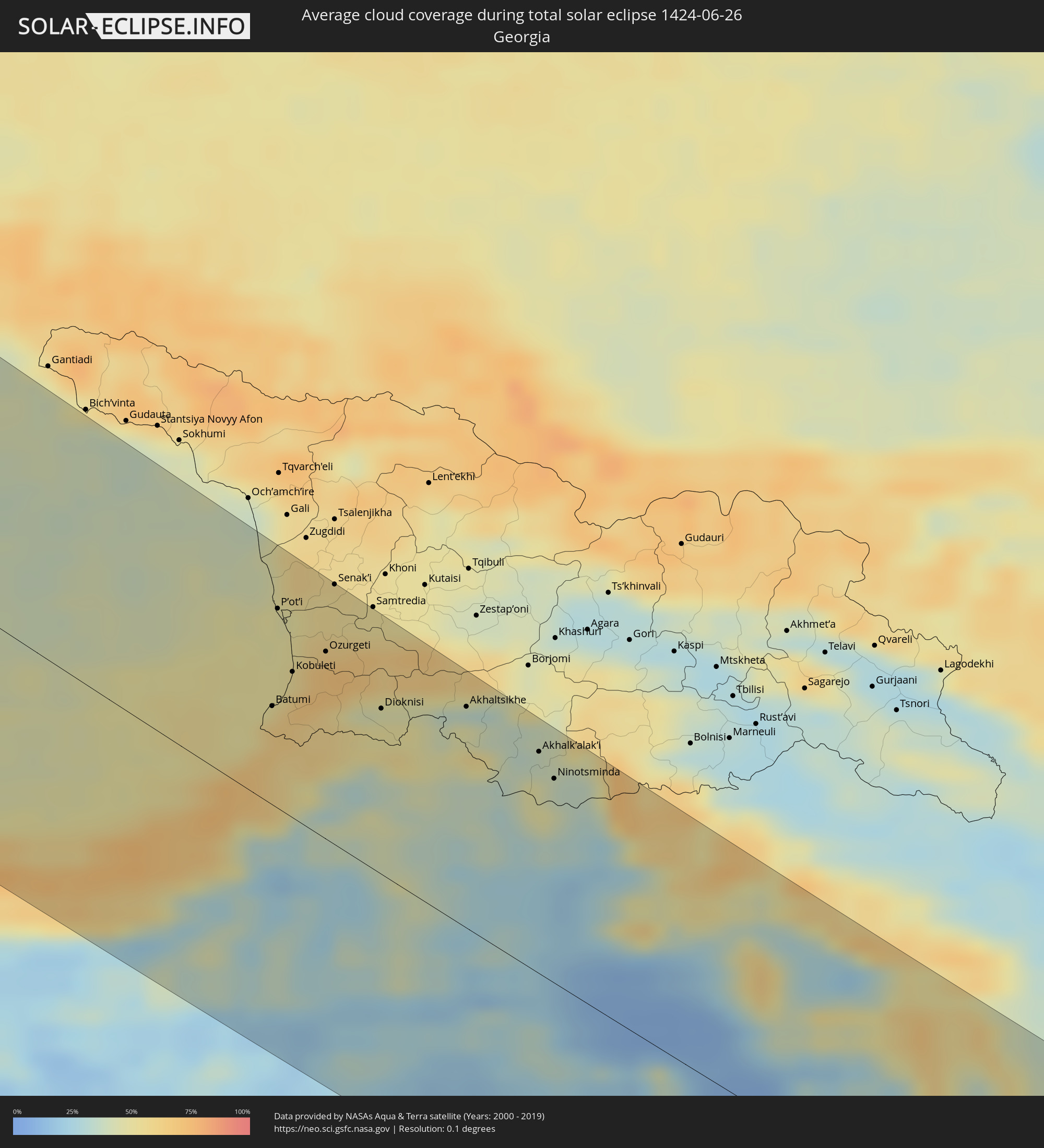
 Georgia
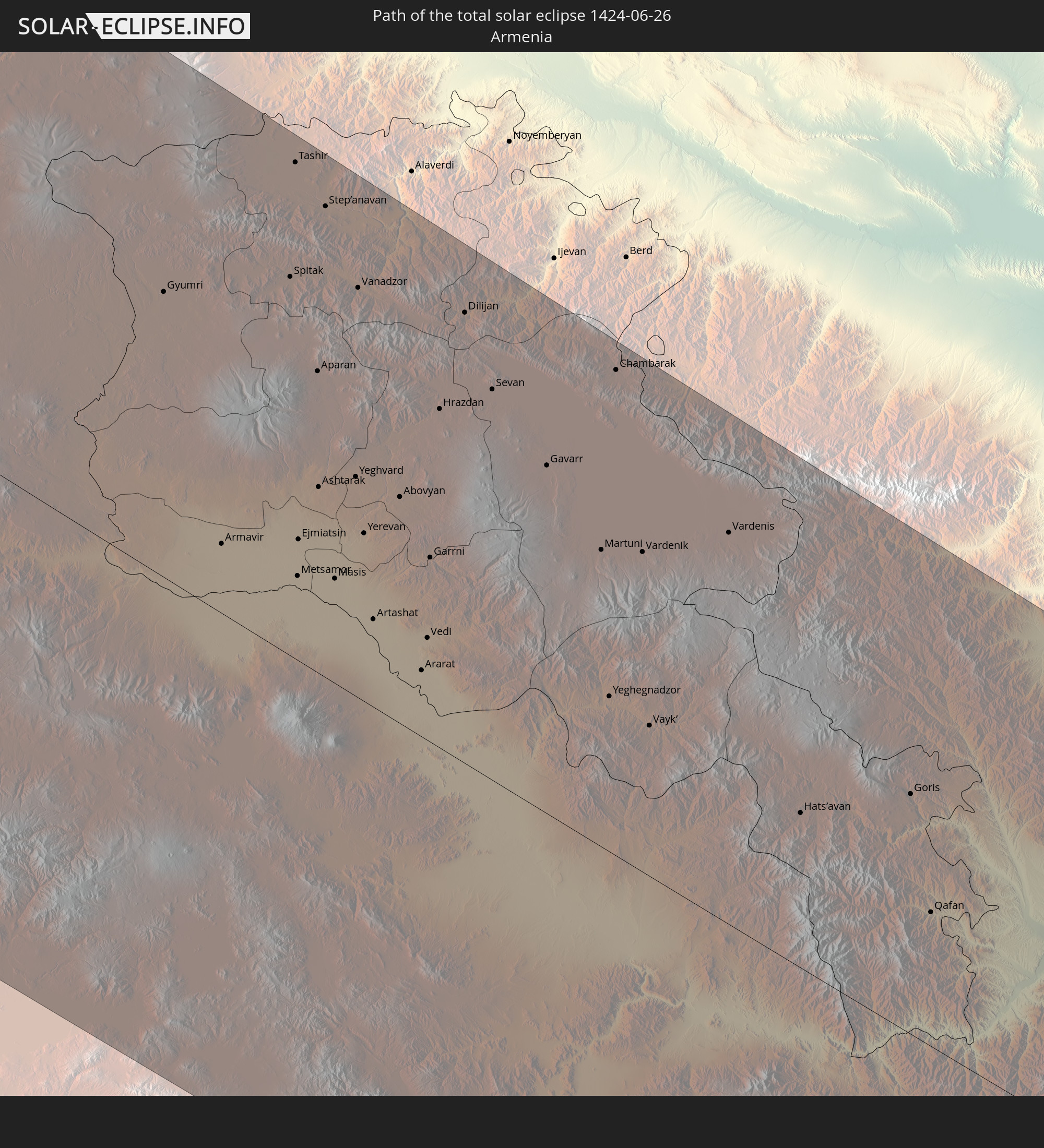 Armenia
 Iran
Iran
 Azerbaijan
In den folgenden Ländern ist die Sonnenfinsternis partiell zu sehen
 Russia
 United States
 United States Minor Outlying Islands
 Canada
 Mexico
 Greenland
 Guatemala
 El Salvador
 Honduras
 Belize
 Nicaragua
 Cuba
Cuba
 Cayman Islands
 The Bahamas
 Jamaica
 Haiti
Haiti
 Turks and Caicos Islands
 Dominican Republic
 Bermuda
 Saint Pierre and Miquelon
 Portugal
 Iceland
 Spain
Spain
 Mauritania
 Morocco
 Mali
Mali
 Republic of Ireland
 Svalbard and Jan Mayen
 Algeria
 United Kingdom
 Faroe Islands
 Gibraltar
 France
 Isle of Man
 Guernsey
 Jersey
 Niger
Niger
 Andorra
 Belgium
 Nigeria
 Netherlands
 Norway
 Luxembourg
 Germany
 Switzerland
 Italy
Italy
 Monaco
 Tunisia
 Denmark
 Cameroon
 Libya
Libya
 Liechtenstein
 Austria
 Sweden
 Czechia
 San Marino
 Vatican City
 Slovenia
 Chad
Chad
 Croatia
 Poland
 Malta
Malta
 Central African Republic
 Bosnia and Herzegovina
 Hungary
 Slovakia
 Montenegro
 Serbia
 Albania
 Åland Islands
 Greece
 Romania
 Republic of Macedonia
 Finland
 Lithuania
 Latvia
 Estonia
 Sudan
Sudan
 Ukraine
 Bulgaria
 Belarus
 Egypt
Egypt
 Turkey
 Moldova
 Cyprus
 State of Palestine
 Israel
 Saudi Arabia
 Jordan
 Lebanon
 Syria
Syria
 Iraq
Iraq
 Georgia
 Armenia
 Iran
Iran
 Azerbaijan
 Kazakhstan
 Turkmenistan
 Uzbekistan
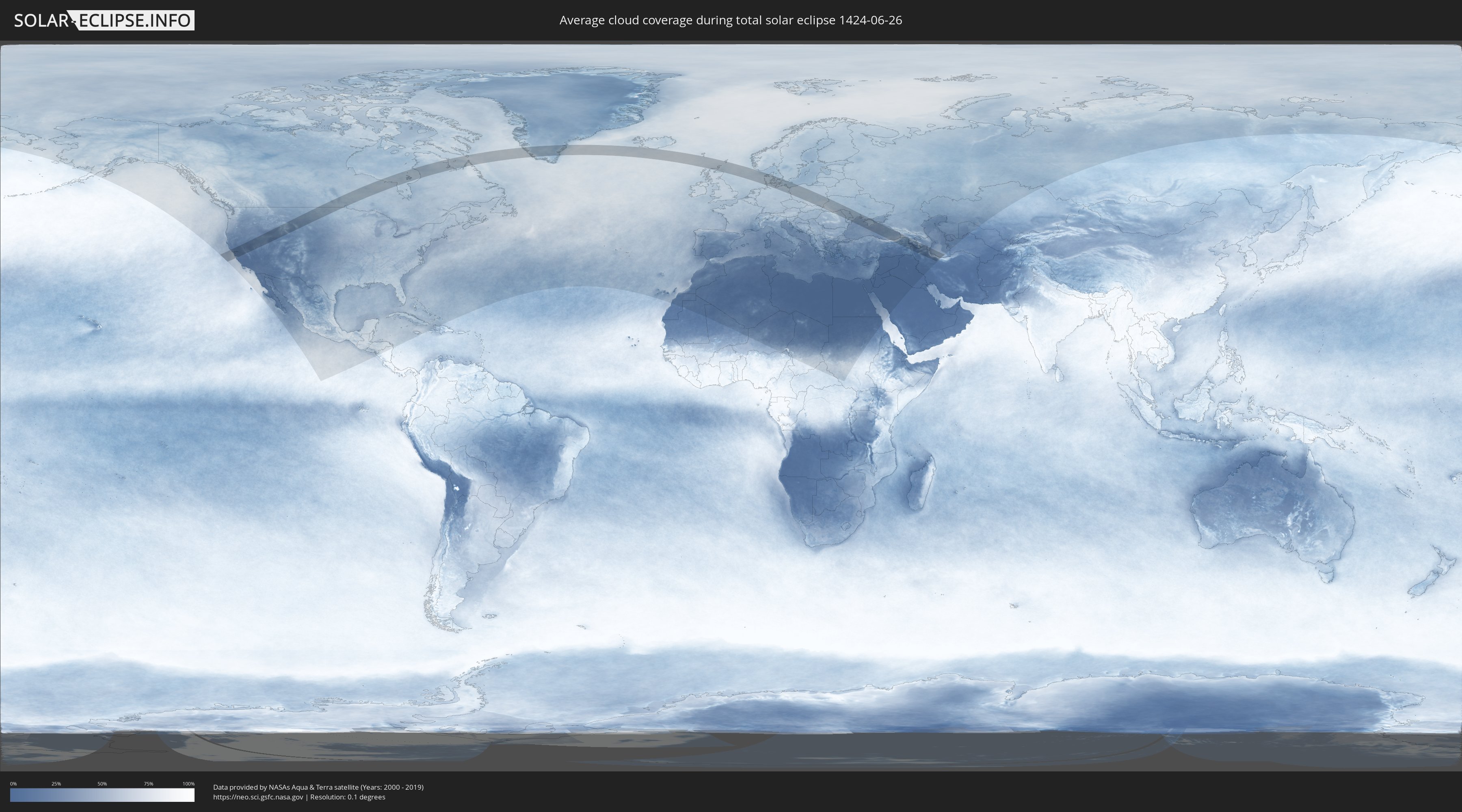
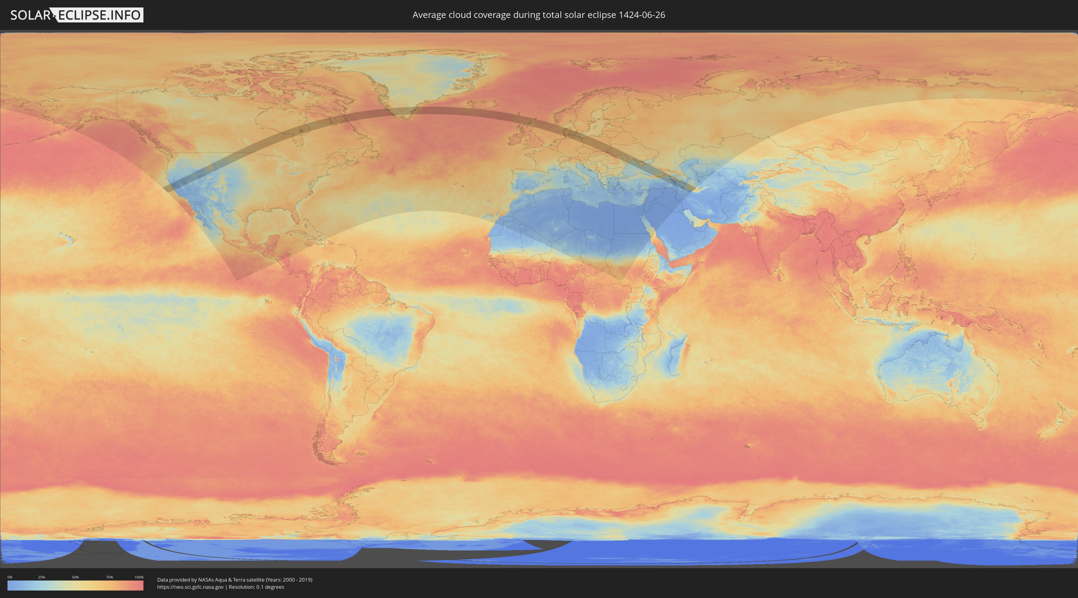
How will be the weather during the total solar eclipse on 06/26/1424?
Where is the best place to see the total solar eclipse of 06/26/1424?
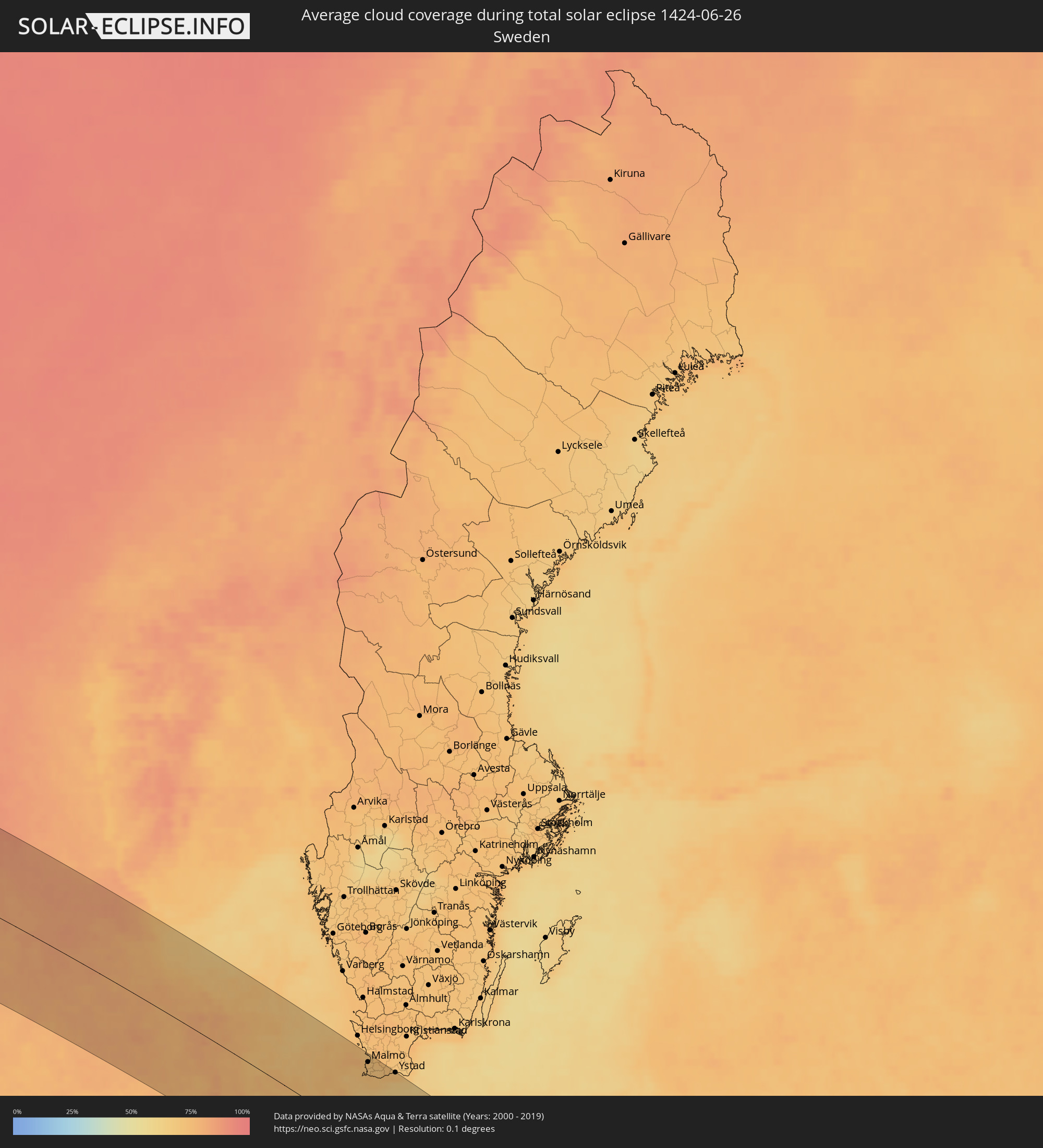
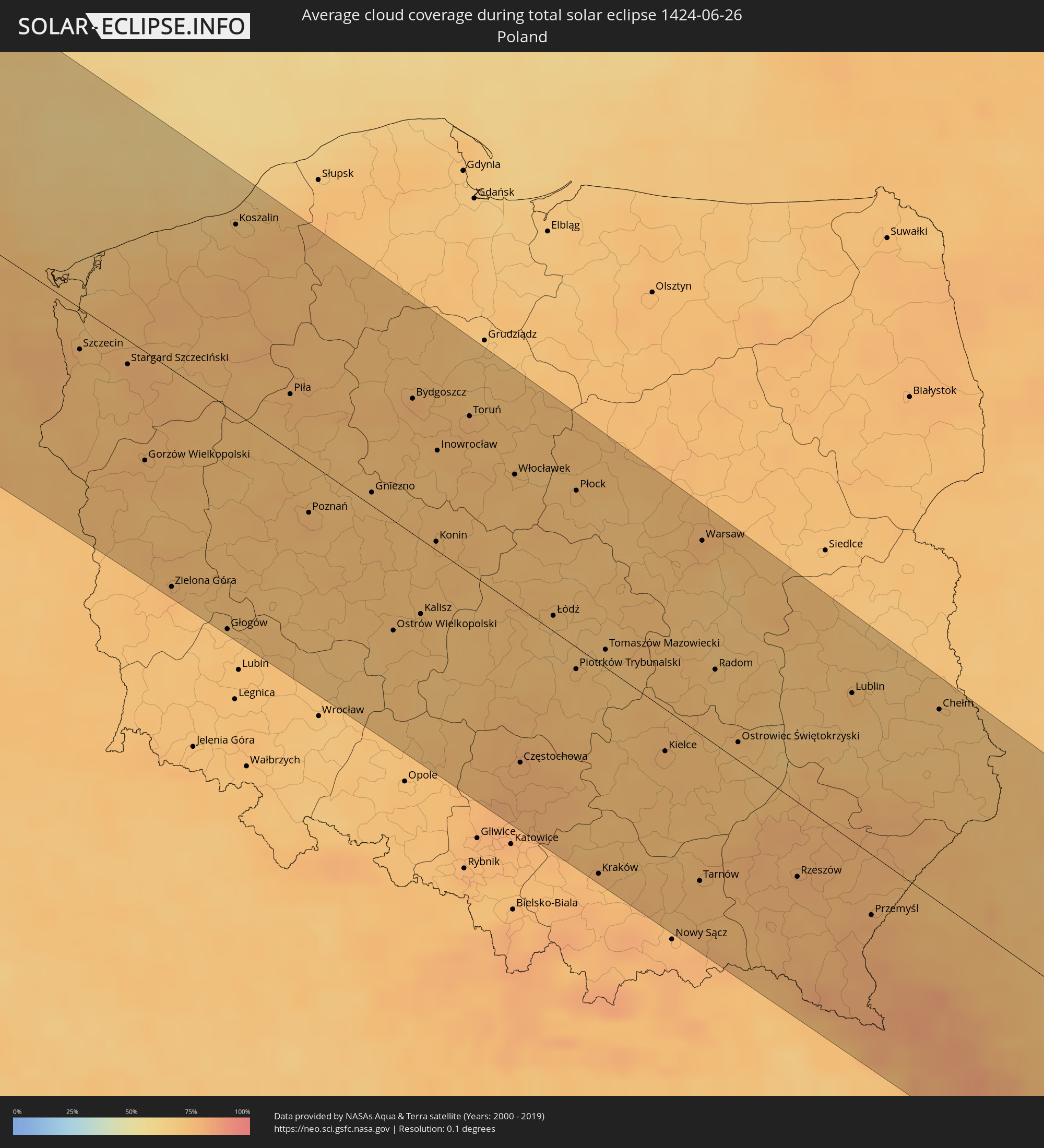
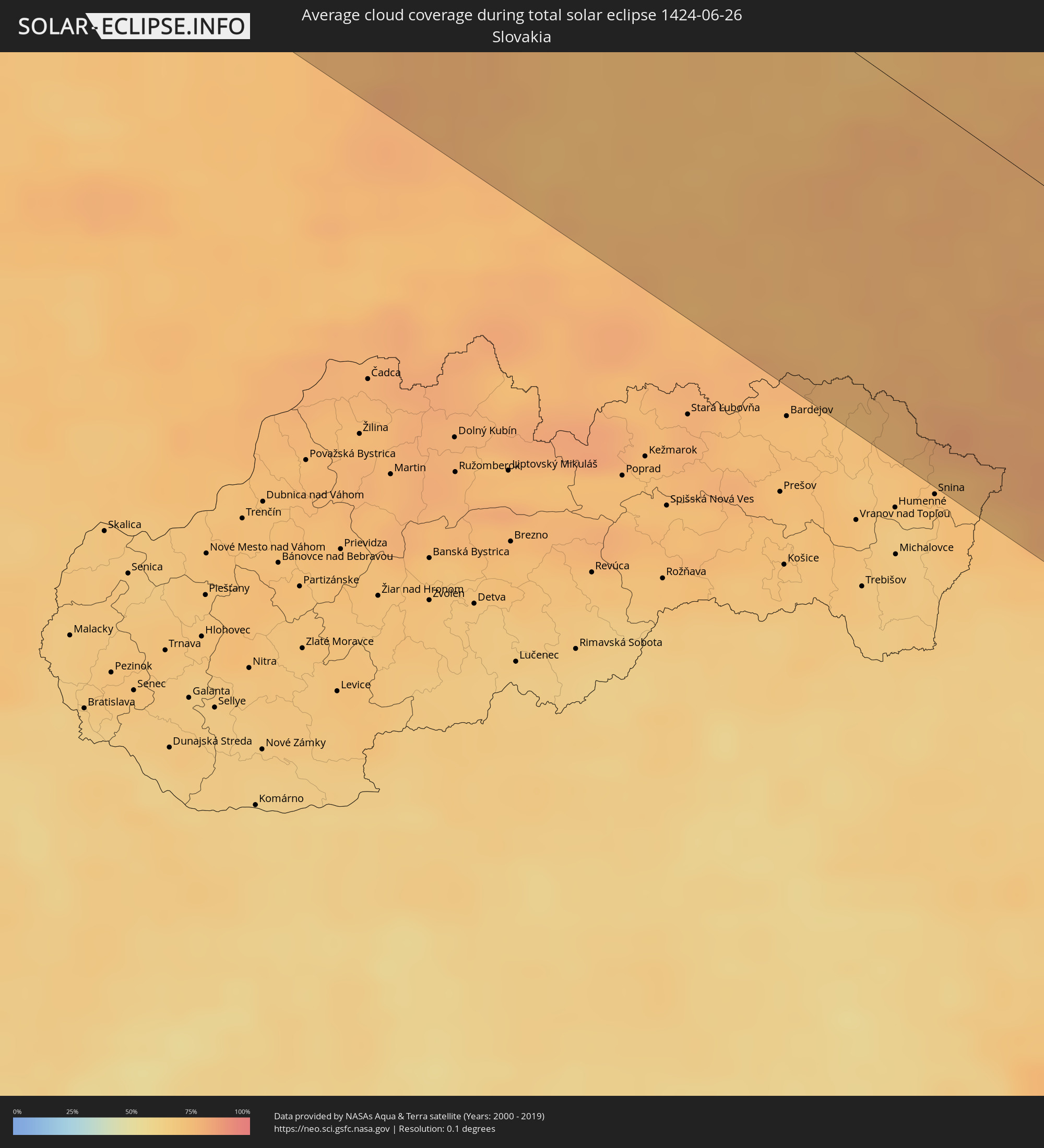
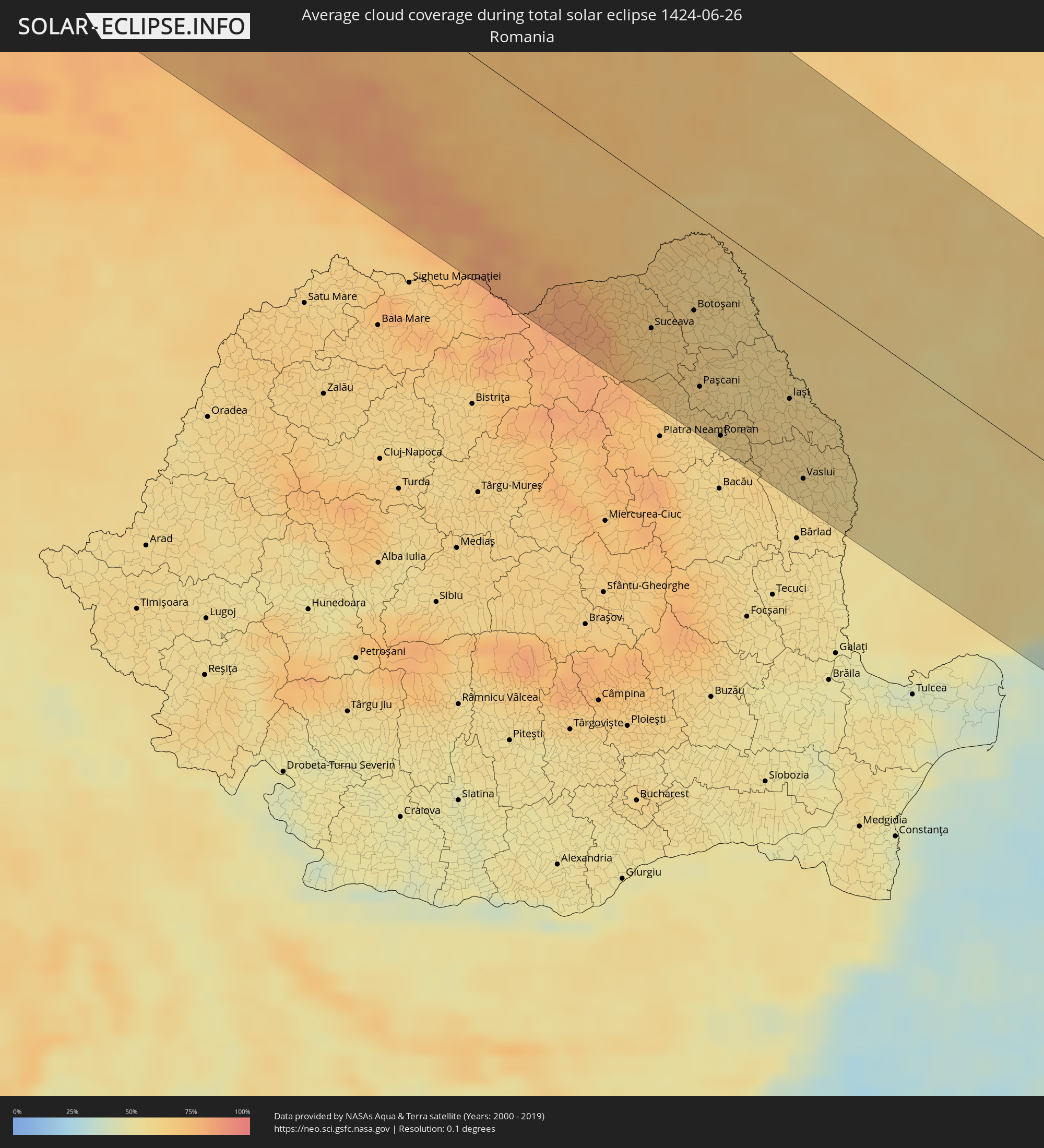
The following maps show the average cloud coverage for the day of the total solar eclipse.
With the help of these maps, it is possible to find the place along the eclipse path, which has the best
chance of a cloudless sky.
Nevertheless, you should consider local circumstances and inform about the weather of your chosen
observation site.
The data is provided by NASAs satellites
AQUA and TERRA.
The cloud maps are averaged over a period of 19 years (2000 - 2019).
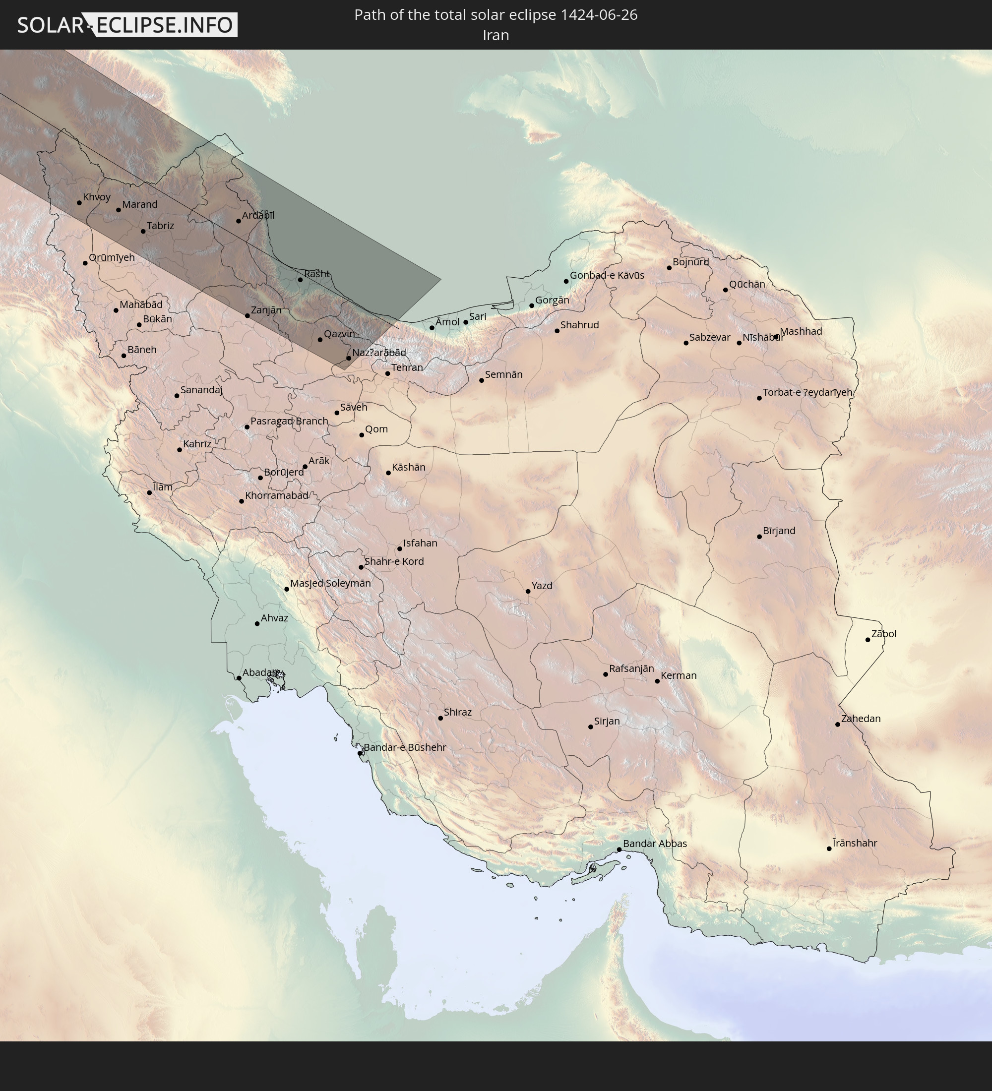
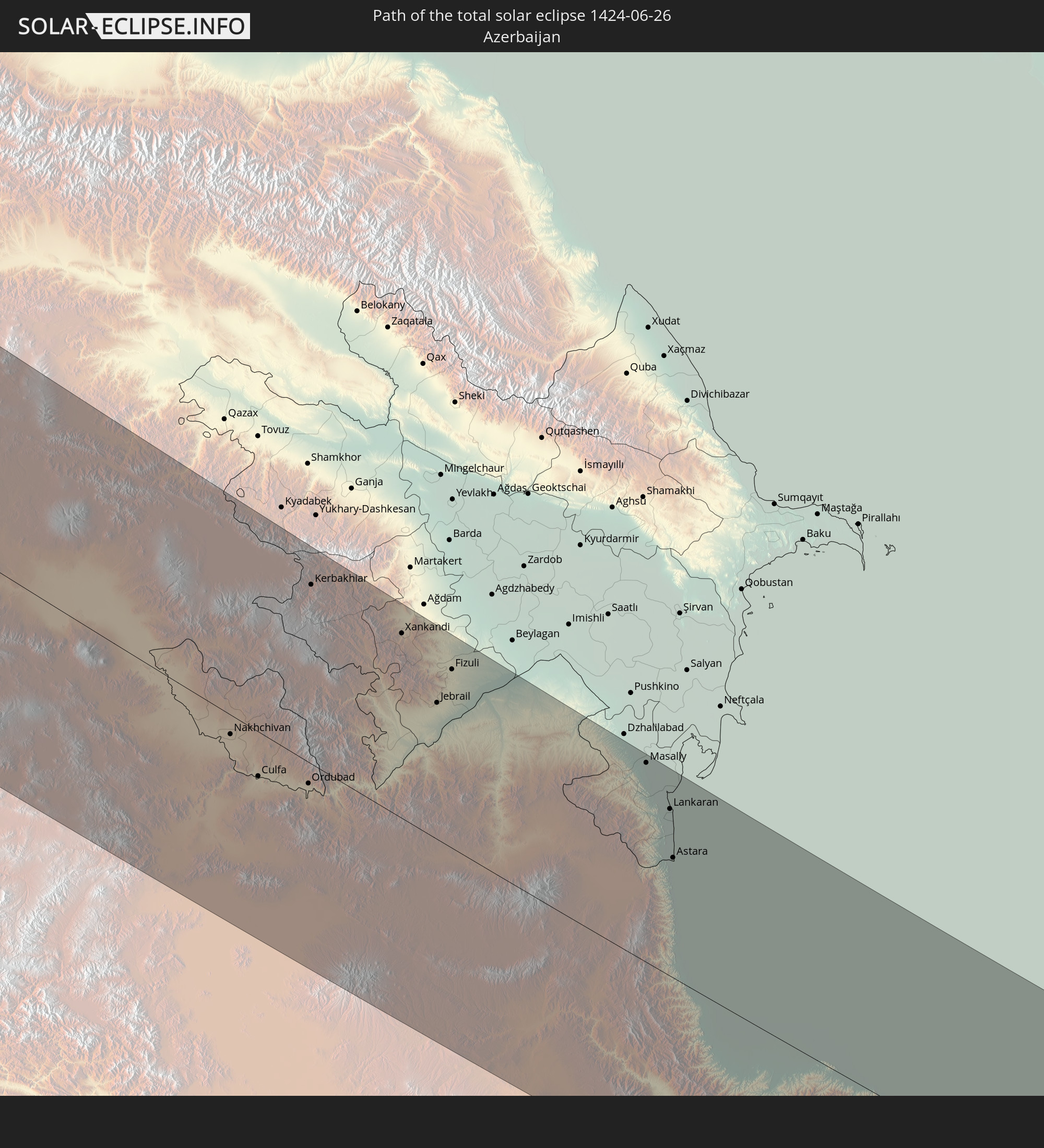
Detailed country maps
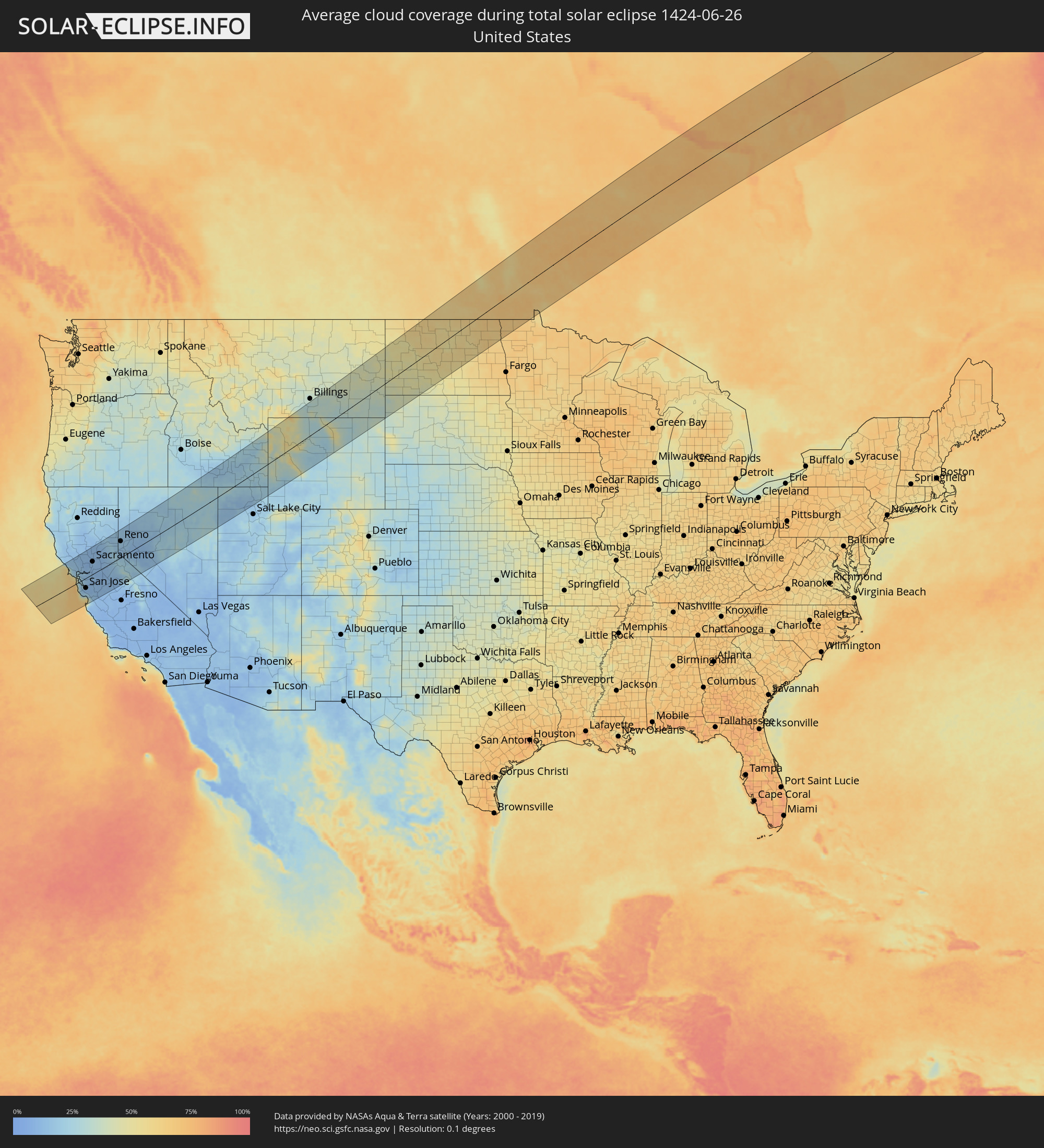 United States
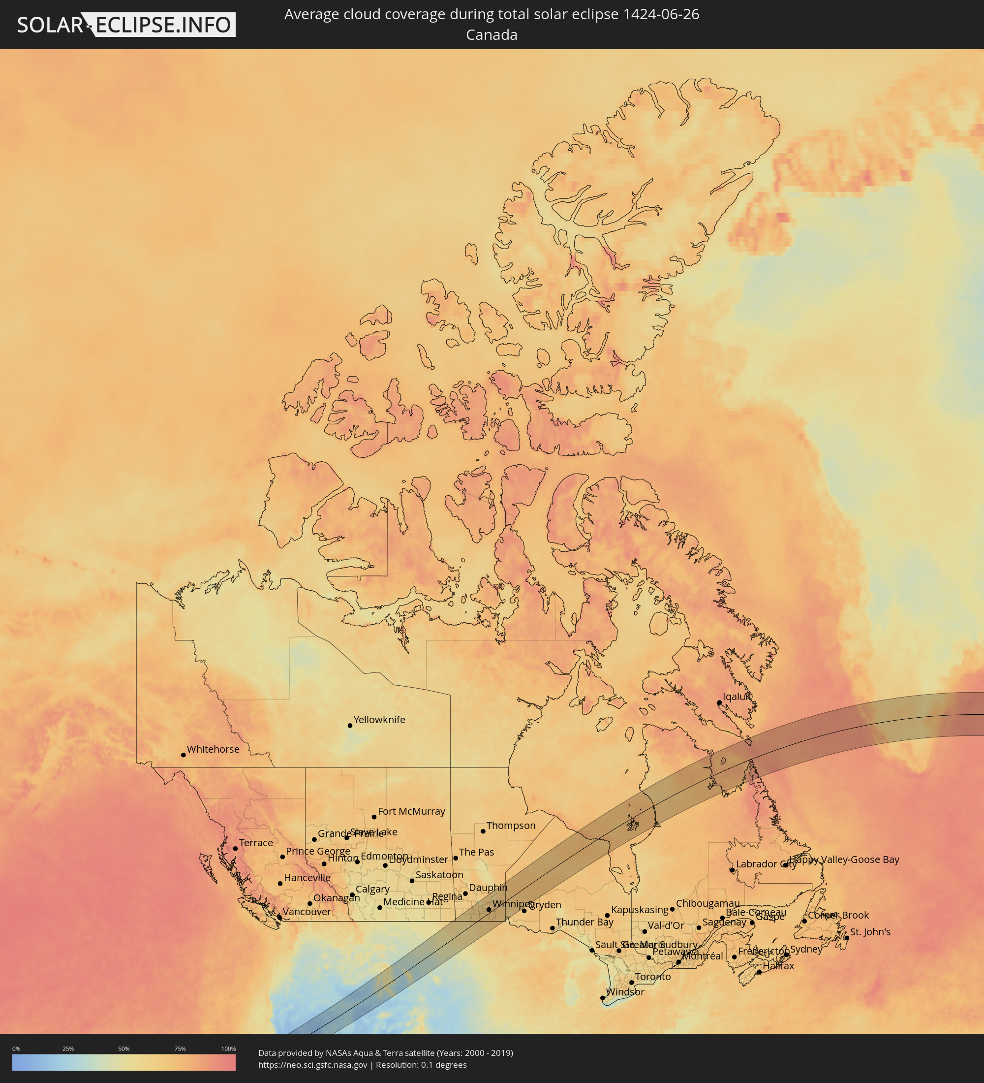 Canada
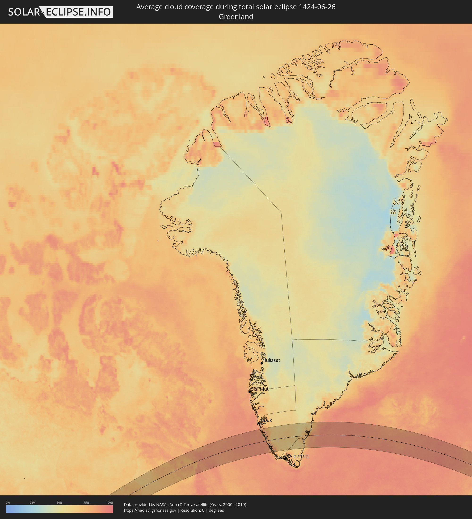 Greenland
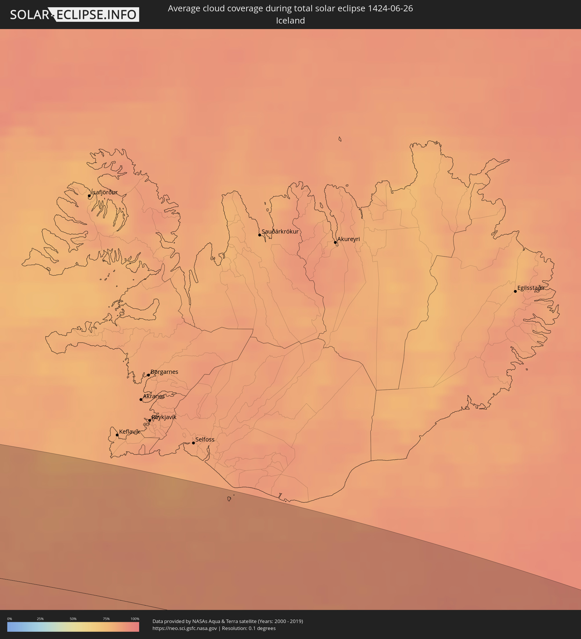 Iceland
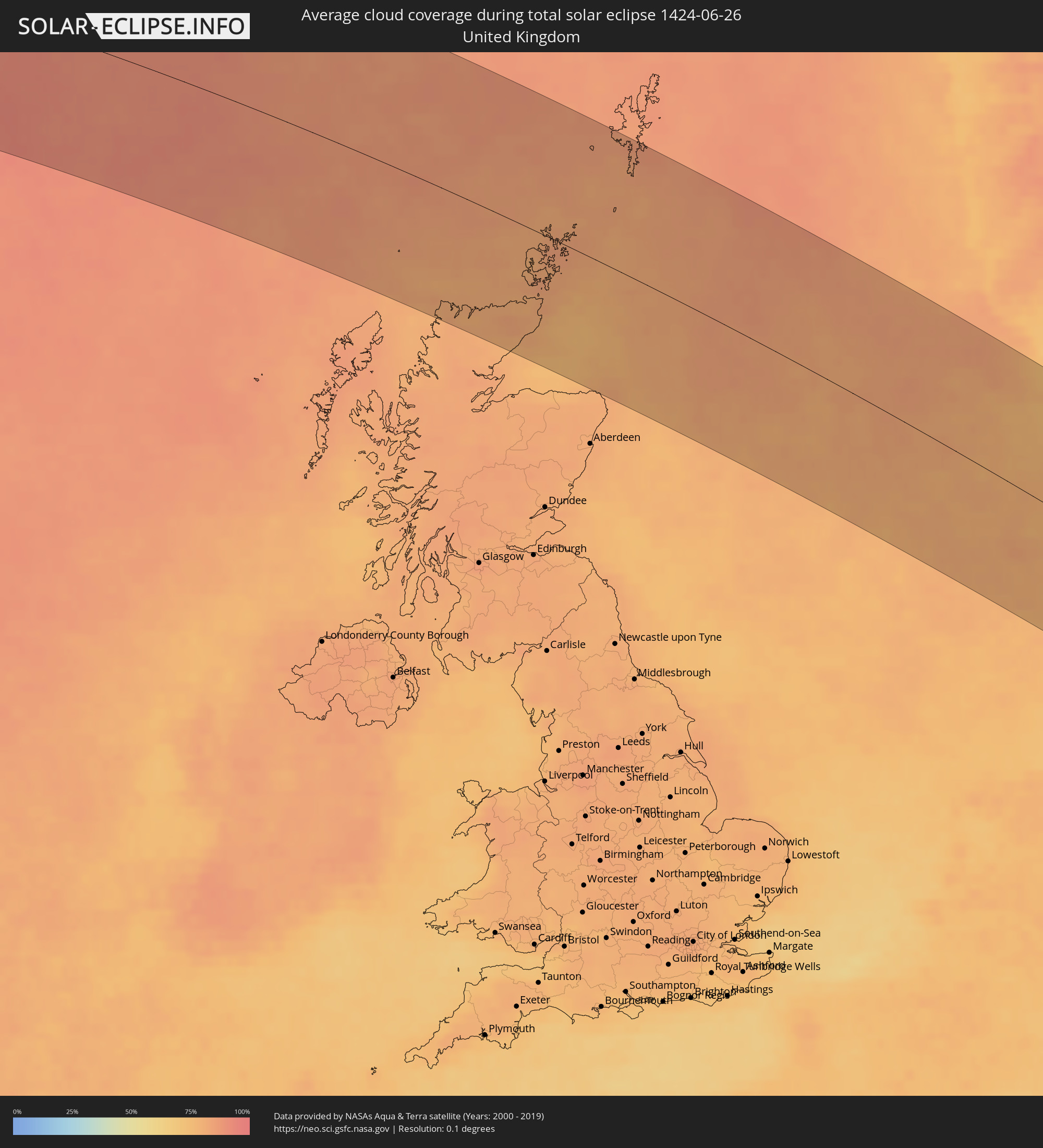 United Kingdom
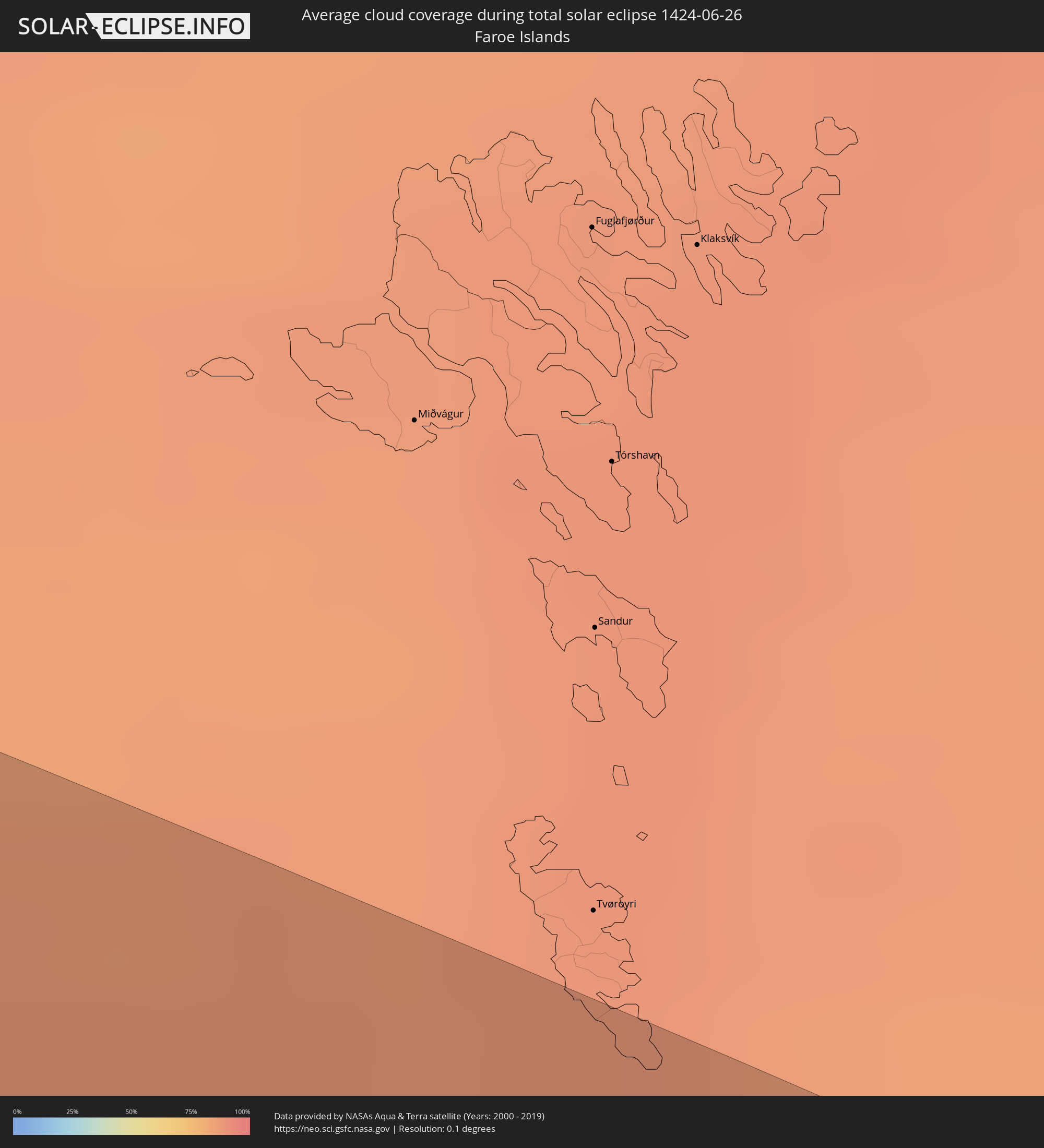 Faroe Islands
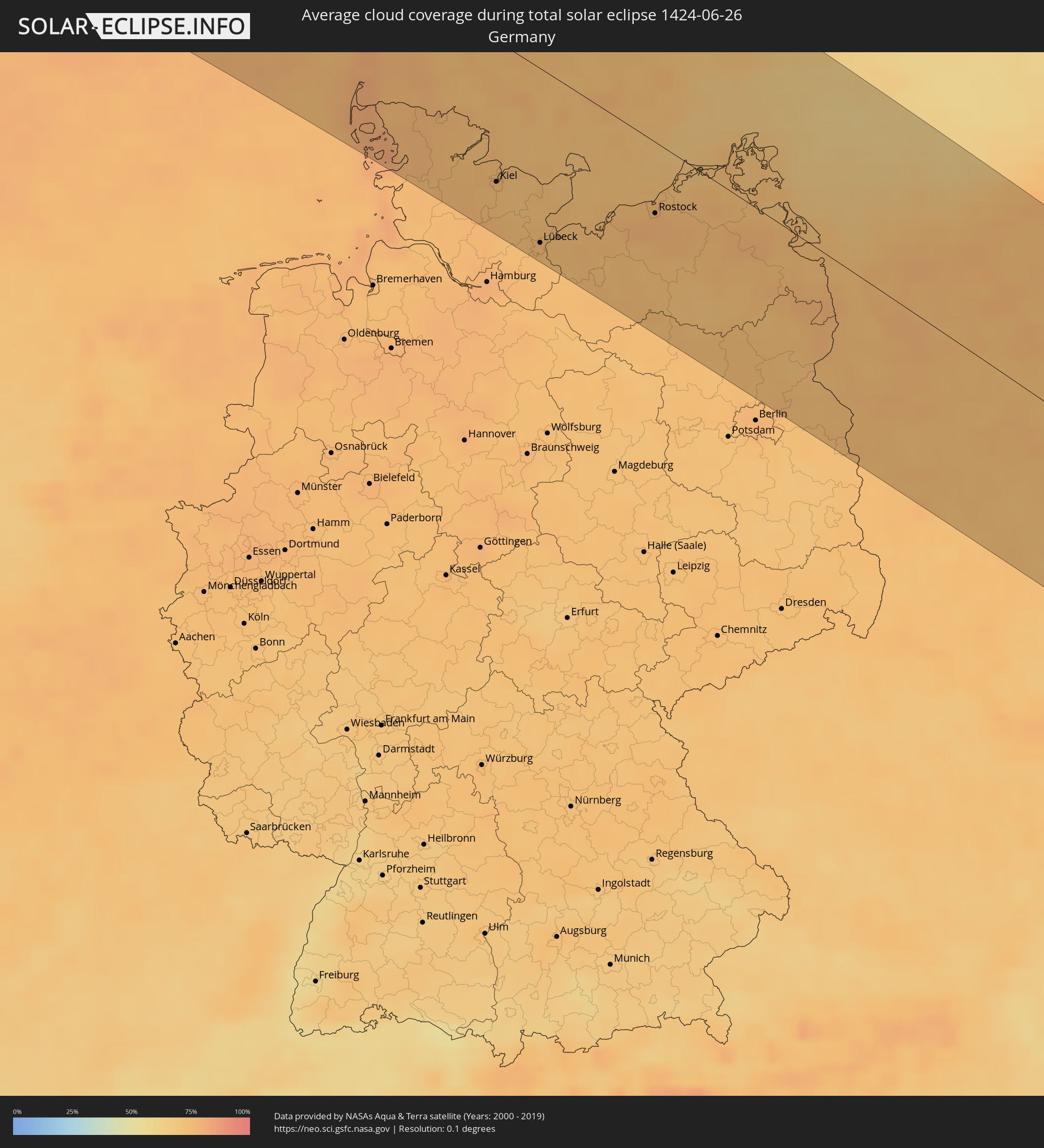 Germany
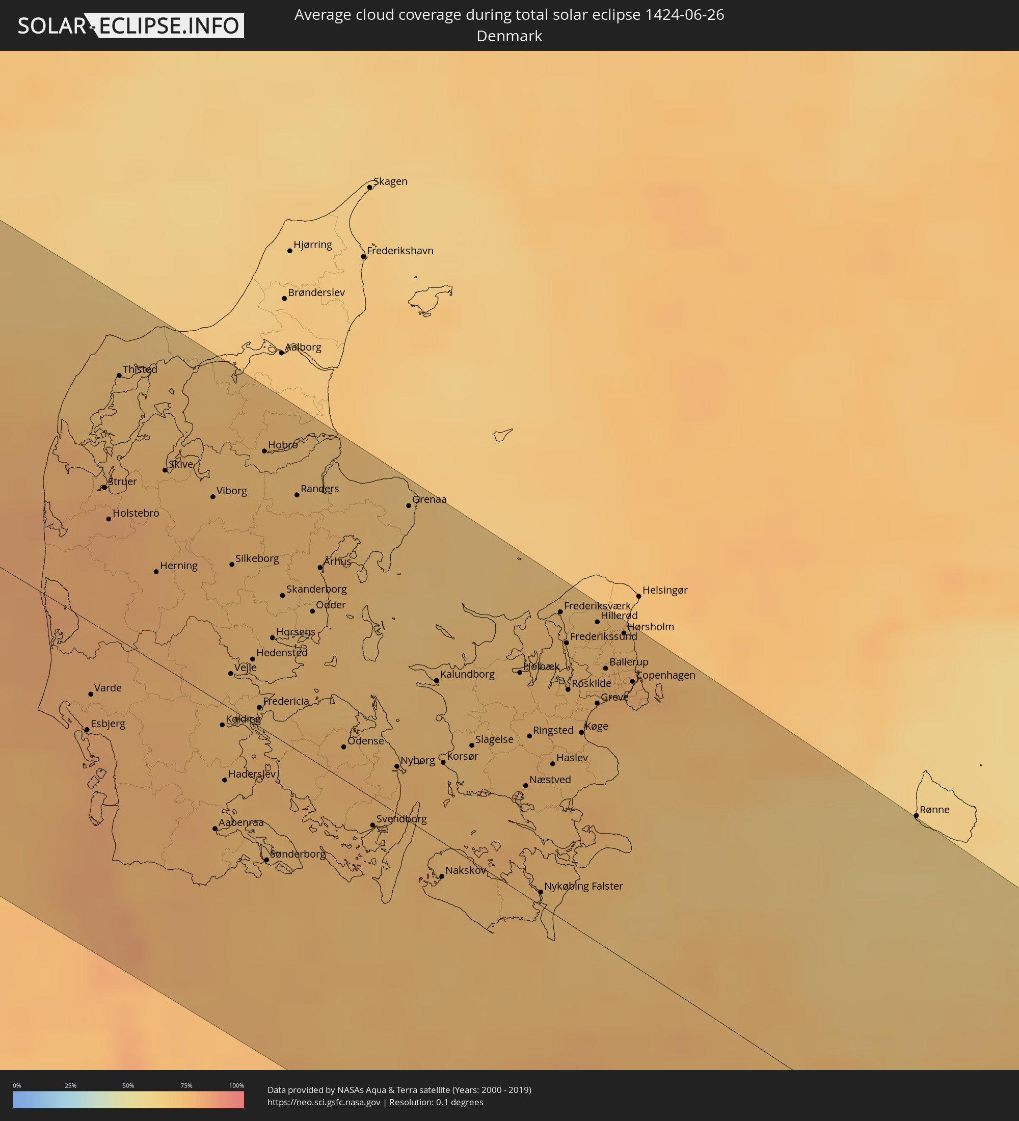 Denmark
 Sweden
 Poland
 Slovakia
 Romania
 Ukraine
 Turkey
 Moldova
 Georgia
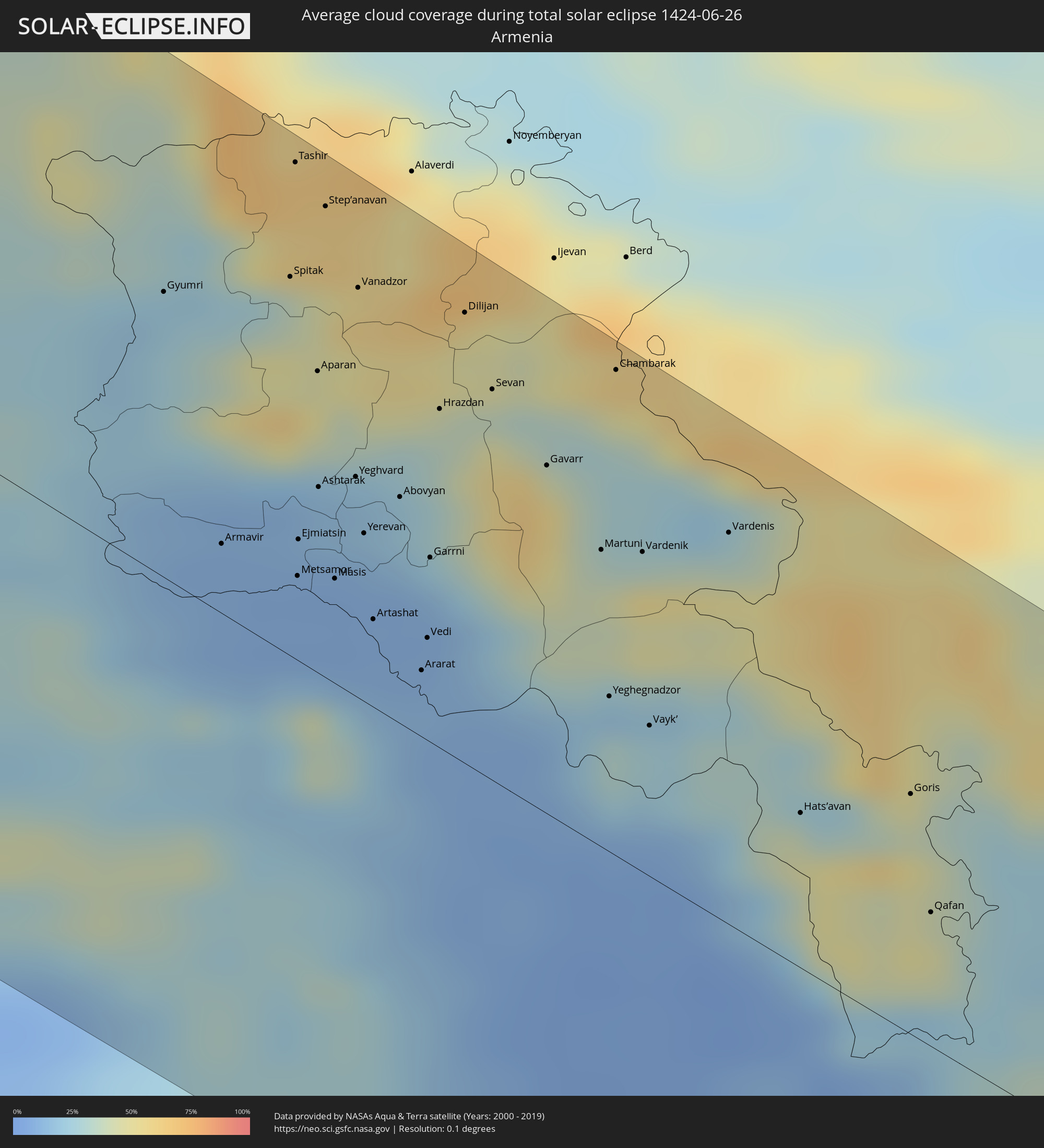 Armenia
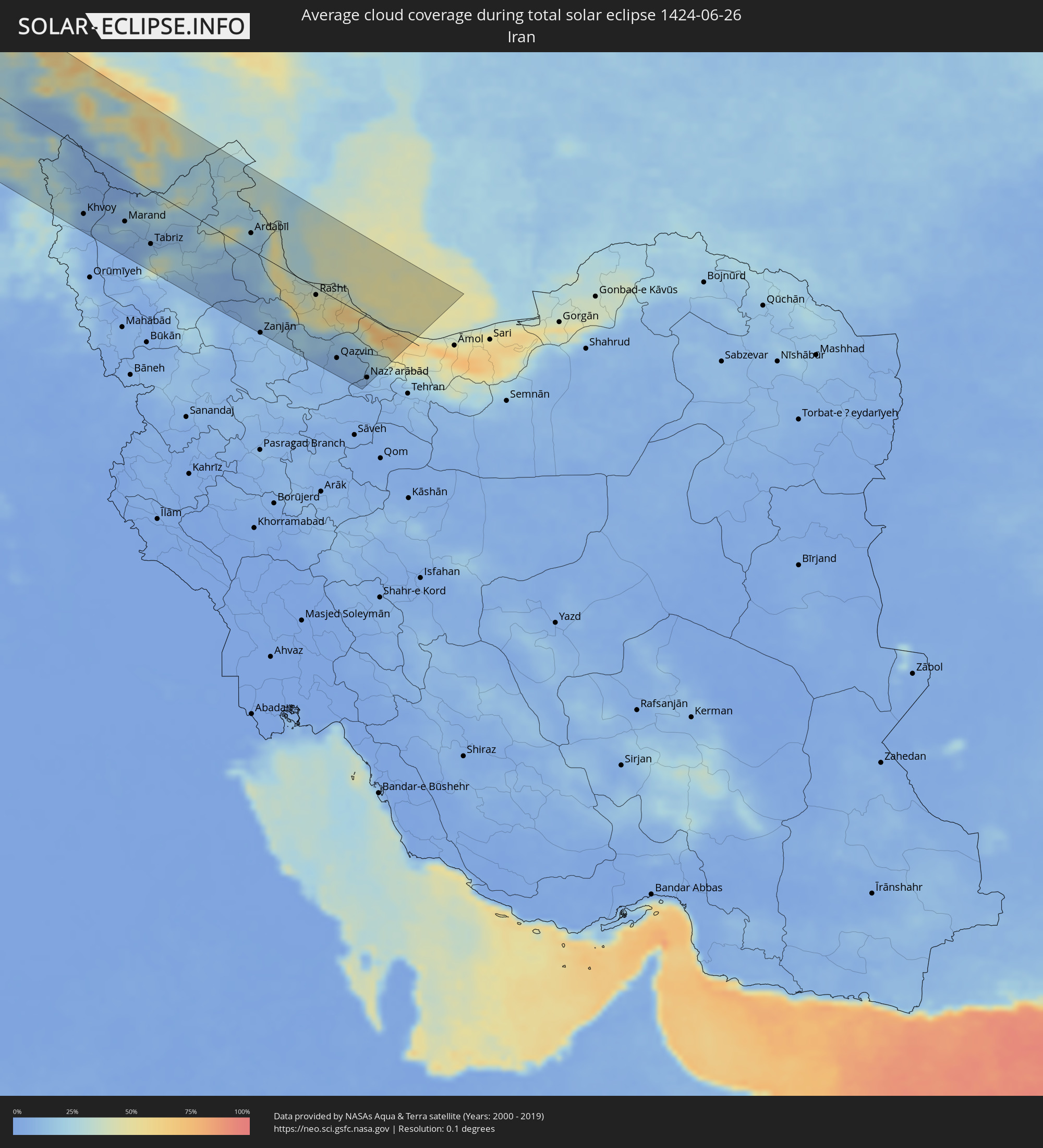 Iran
Iran
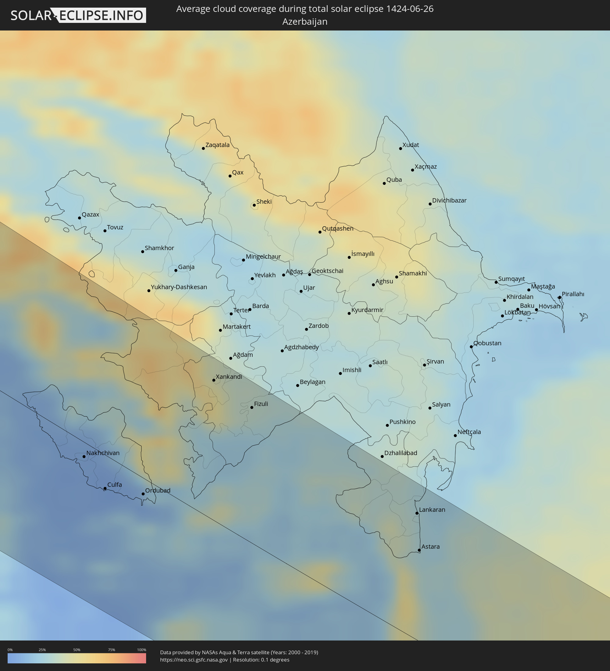 Azerbaijan
Cities inside the path of the eclipse
The following table shows all locations with a population of more than 5,000 inside the eclipse path. Cities which have more than 100,000 inhabitants are marked bold. A click at the locations opens a detailed map.
| City | Type | Eclipse duration | Local time of max. eclipse | Distance to central line | Ø Cloud coverage |
|
Santa Rosa, California
|
total | - | 05:11:15 UTC-08:00 | 98 km | 18% |
|
San Francisco, California
|
total | - | 05:10:24 UTC-08:00 | 28 km | 38% |
|
Hayward, California
|
total | - | 05:10:09 UTC-08:00 | 13 km | 20% |
|
Concord, California
|
total | - | 05:10:28 UTC-08:00 | 24 km | 13% |
|
Fremont, California
|
total | - | 05:09:59 UTC-08:00 | 24 km | 25% |
|
San Jose, California
|
total | - | 05:09:43 UTC-08:00 | 48 km | 11% |
|
Salinas, California
|
total | - | 05:08:54 UTC-08:00 | 121 km | 29% |
|
Sacramento, California
|
total | - | 05:10:56 UTC-08:00 | 59 km | 12% |
|
Elk Grove, California
|
total | - | 05:10:41 UTC-08:00 | 38 km | 12% |
|
Stockton, California
|
total | - | 05:10:09 UTC-08:00 | 19 km | 10% |
|
Roseville, California
|
total | - | 05:11:02 UTC-08:00 | 64 km | 12% |
|
Modesto, California
|
total | - | 05:09:41 UTC-08:00 | 59 km | 12% |
|
Reno, Nevada
|
total | - | 05:11:24 UTC-08:00 | 73 km | 16% |
|
Brandon, Manitoba
|
total | - | 07:23:41 UTC-06:00 | 134 km | 60% |
|
Portage la Prairie, Manitoba
|
total | - | 07:24:11 UTC-06:00 | 77 km | 65% |
|
Morden, Manitoba
|
total | - | 07:23:00 UTC-06:00 | 12 km | 64% |
|
Winkler, Manitoba
|
total | - | 07:23:01 UTC-06:00 | 12 km | 65% |
|
Winnipeg, Manitoba
|
total | - | 07:24:17 UTC-06:00 | 19 km | 72% |
|
Selkirk, Manitoba
|
total | - | 07:24:45 UTC-06:00 | 34 km | 64% |
|
Steinbach, Manitoba
|
total | - | 07:23:50 UTC-06:00 | 33 km | 69% |
|
Thurso, Scotland
|
total | - | 15:06:19 UTC+00:00 | 82 km | 79% |
|
Wick, Scotland
|
total | - | 15:06:53 UTC+00:00 | 87 km | 79% |
|
Orkney, Scotland
|
total | - | 15:06:14 UTC+00:00 | 33 km | 80% |
|
Kirkwall, Scotland
|
total | - | 15:06:14 UTC+00:00 | 33 km | 80% |
|
Lerwick, Scotland
|
total | - | 15:05:59 UTC+00:00 | 134 km | 86% |
|
Shetland, Scotland
|
total | - | 15:05:59 UTC+00:00 | 134 km | 86% |
|
Esbjerg, South Denmark
|
total | - | 16:19:38 UTC+01:00 | 46 km | 78% |
|
Herning, Central Jutland
|
total | - | 16:18:52 UTC+01:00 | 36 km | 77% |
|
Flensburg, Schleswig-Holstein
|
total | - | 16:21:19 UTC+01:00 | 77 km | 75% |
|
Kolding, South Denmark
|
total | - | 16:20:12 UTC+01:00 | 9 km | 72% |
|
Vejle, South Denmark
|
total | - | 16:19:53 UTC+01:00 | 15 km | 71% |
|
Silkeborg, Central Jutland
|
total | - | 16:19:09 UTC+01:00 | 58 km | 75% |
|
Horsens, Central Jutland
|
total | - | 16:19:49 UTC+01:00 | 39 km | 72% |
|
Neumünster, Schleswig-Holstein
|
total | - | 16:22:46 UTC+01:00 | 125 km | 76% |
|
Randers, Central Jutland
|
total | - | 16:18:57 UTC+01:00 | 102 km | 73% |
|
Kiel, Schleswig-Holstein
|
total | - | 16:22:27 UTC+01:00 | 97 km | 73% |
|
Århus, Central Jutland
|
total | - | 16:19:32 UTC+01:00 | 79 km | 74% |
|
Odense, South Denmark
|
total | - | 16:20:52 UTC+01:00 | 21 km | 75% |
|
Lübeck, Schleswig-Holstein
|
total | - | 16:23:29 UTC+01:00 | 121 km | 74% |
|
Schwerin, Mecklenburg-Vorpommern
|
total | - | 16:24:16 UTC+01:00 | 118 km | 75% |
|
Wismar, Mecklenburg-Vorpommern
|
total | - | 16:23:52 UTC+01:00 | 93 km | 75% |
|
Næstved, Zealand
|
total | - | 16:21:52 UTC+01:00 | 45 km | 71% |
|
Roskilde, Zealand
|
total | - | 16:21:22 UTC+01:00 | 95 km | 74% |
|
Rostock, Mecklenburg-Vorpommern
|
total | - | 16:23:55 UTC+01:00 | 49 km | 77% |
|
Greve, Zealand
|
total | - | 16:21:34 UTC+01:00 | 96 km | 74% |
|
Copenhagen, Capital Region
|
total | - | 16:21:33 UTC+01:00 | 114 km | 76% |
|
Skanör med Falsterbo, Skåne
|
total | - | 16:22:08 UTC+01:00 | 98 km | 72% |
|
Bunkeflostrand, Skåne
|
total | - | 16:21:58 UTC+01:00 | 114 km | 70% |
|
Höllviken, Skåne
|
total | - | 16:22:11 UTC+01:00 | 103 km | 73% |
|
Malmö, Skåne
|
total | - | 16:21:53 UTC+01:00 | 123 km | 72% |
|
Bjärred, Skåne
|
total | - | 16:21:42 UTC+01:00 | 134 km | 74% |
|
Lomma, Skåne
|
total | - | 16:21:48 UTC+01:00 | 131 km | 70% |
|
Arlöv, Skåne
|
total | - | 16:21:52 UTC+01:00 | 127 km | 72% |
|
Stralsund, Mecklenburg-Vorpommern
|
total | - | 16:24:02 UTC+01:00 | 6 km | 73% |
|
Oxie, Skåne
|
total | - | 16:22:02 UTC+01:00 | 120 km | 70% |
|
Trelleborg, Skåne
|
total | - | 16:22:20 UTC+01:00 | 108 km | 72% |
|
Staffanstorp, Skåne
|
total | - | 16:21:55 UTC+01:00 | 133 km | 71% |
|
Svedala, Skåne
|
total | - | 16:22:09 UTC+01:00 | 122 km | 70% |
|
Neubrandenburg, Mecklenburg-Vorpommern
|
total | - | 16:25:20 UTC+01:00 | 61 km | 73% |
|
Greifswald, Mecklenburg-Vorpommern
|
total | - | 16:24:32 UTC+01:00 | 7 km | 74% |
|
Skurup, Skåne
|
total | - | 16:22:20 UTC+01:00 | 128 km | 72% |
|
Eberswalde, Brandenburg
|
total | - | 16:26:47 UTC+01:00 | 107 km | 75% |
|
Ystad, Skåne
|
total | - | 16:22:34 UTC+01:00 | 135 km | 73% |
|
Schwedt (Oder), Brandenburg
|
total | - | 16:26:38 UTC+01:00 | 69 km | 76% |
|
Frankfurt (Oder), Brandenburg
|
total | - | 16:27:55 UTC+01:00 | 124 km | 73% |
|
Szczecin, West Pomeranian Voivodeship
|
total | - | 16:50:10 UTC+01:24 | 31 km | 73% |
|
Poznań, Greater Poland Voivodeship
|
total | - | 16:52:51 UTC+01:24 | 29 km | 76% |
|
Bydgoszcz, Kujawsko-Pomorskie
|
total | - | 16:52:06 UTC+01:24 | 79 km | 75% |
|
Toruń, Kujawsko-Pomorskie
|
total | - | 16:52:30 UTC+01:24 | 92 km | 76% |
|
Częstochowa, Silesian Voivodeship
|
total | - | 16:56:16 UTC+01:24 | 92 km | 78% |
|
Dąbrowa Górnicza, Silesian Voivodeship
|
total | - | 16:57:04 UTC+01:24 | 132 km | 77% |
|
Łódź, Łódź Voivodeship
|
total | - | 16:54:51 UTC+01:24 | 13 km | 74% |
|
Kraków, Lesser Poland Voivodeship
|
total | - | 16:57:43 UTC+01:24 | 127 km | 77% |
|
Kielce, Świętokrzyskie
|
total | - | 16:56:38 UTC+01:24 | 29 km | 75% |
|
Warsaw, Masovian Voivodeship
|
total | - | 16:54:34 UTC+01:24 | 114 km | 76% |
|
Radom, Masovian Voivodeship
|
total | - | 16:55:57 UTC+01:24 | 48 km | 72% |
|
Svidník, Prešovský
|
total | - | 16:35:24 UTC+01:00 | 130 km | 72% |
|
Medzilaborce, Prešovský
|
total | - | 16:35:33 UTC+01:00 | 120 km | 75% |
|
Rzeszów, Subcarpathian Voivodeship
|
total | - | 16:58:22 UTC+01:24 | 47 km | 77% |
|
Lublin, Lublin Voivodeship
|
total | - | 16:56:35 UTC+01:24 | 89 km | 74% |
|
Lviv, Lviv
|
total | - | 17:37:15 UTC+02:02 | 24 km | 75% |
|
Chervonohrad, Lviv
|
total | - | 17:36:25 UTC+02:02 | 79 km | 71% |
|
Ivano-Frankivs’k, Ivano-Frankivsk
|
total | - | 17:38:50 UTC+02:02 | 34 km | 72% |
|
Câmpulung Moldovenesc, Suceava
|
total | - | 17:23:28 UTC+01:44 | 125 km | 81% |
|
Ternopil’, Ternopil
|
total | - | 17:38:01 UTC+02:02 | 62 km | 71% |
|
Gura Humorului, Suceava
|
total | - | 17:23:30 UTC+01:44 | 111 km | 74% |
|
Rădăuți, Suceava
|
total | - | 17:23:03 UTC+01:44 | 81 km | 71% |
|
Chernivtsi, Chernivtsi
|
total | - | 17:40:02 UTC+02:02 | 46 km | 69% |
|
Suceava, Suceava
|
total | - | 17:23:26 UTC+01:44 | 87 km | 64% |
|
Fălticeni, Suceava
|
total | - | 17:23:43 UTC+01:44 | 101 km | 63% |
|
Târgu Neamţ, Neamţ
|
total | - | 17:24:07 UTC+01:44 | 123 km | 64% |
|
Dorohoi, Botoşani
|
total | - | 17:22:58 UTC+01:44 | 54 km | 64% |
|
Kamieniec Podolski, Khmelnytskyi
|
total | - | 17:39:32 UTC+02:02 | 25 km | 67% |
|
Botoşani, Botoşani
|
total | - | 17:23:19 UTC+01:44 | 59 km | 60% |
|
Paşcani, Iaşi
|
total | - | 17:24:06 UTC+01:44 | 101 km | 62% |
|
Roman, Neamţ
|
total | - | 17:24:37 UTC+01:44 | 123 km | 60% |
|
Khmel’nyts’kyy, Khmelnytskyi
|
total | - | 17:38:27 UTC+02:02 | 108 km | 69% |
|
Edineţ, Raionul Edineţ
|
total | - | 17:33:22 UTC+01:55 | 23 km | 62% |
|
Iaşi, Iaşi
|
total | - | 17:24:20 UTC+01:44 | 72 km | 62% |
|
Vaslui, Vaslui
|
total | - | 17:25:09 UTC+01:44 | 114 km | 58% |
|
Ungheni, Ungheni
|
total | - | 17:34:53 UTC+01:55 | 62 km | 60% |
|
Bălţi, Bălţi
|
total | - | 17:34:04 UTC+01:55 | 5 km | 62% |
|
Huşi, Vaslui
|
total | - | 17:25:08 UTC+01:44 | 98 km | 56% |
|
Soroca, Raionul Soroca
|
total | - | 17:33:30 UTC+01:55 | 50 km | 61% |
|
Straşeni, Strășeni
|
total | - | 17:35:05 UTC+01:55 | 33 km | 57% |
|
Comrat, Găgăuzia
|
total | - | 17:36:21 UTC+01:55 | 105 km | 54% |
|
Orhei, Orhei
|
total | - | 17:34:44 UTC+01:55 | 18 km | 58% |
|
Ceadîr-Lunga, Găgăuzia
|
total | - | 17:36:43 UTC+01:55 | 120 km | 53% |
|
Chisinau, Chişinău
|
total | - | 17:35:18 UTC+01:55 | 32 km | 58% |
|
Rîbniţa, Stînga Nistrului
|
total | - | 17:34:10 UTC+01:55 | 47 km | 59% |
|
Dubăsari, Teleneşti
|
total | - | 17:34:57 UTC+01:55 | 13 km | 56% |
|
Căuşeni, Căuşeni
|
total | - | 17:35:54 UTC+01:55 | 45 km | 57% |
|
Tiraspolul, Stînga Nistrului
|
total | - | 17:35:37 UTC+01:55 | 24 km | 56% |
|
Odessa, Odessa
|
total | - | 17:43:17 UTC+02:02 | 20 km | 52% |
|
Mykolayiv, Mykolaiv
|
total | - | 17:42:36 UTC+02:02 | 105 km | 54% |
|
Kherson, Kherson
|
total | - | 17:43:04 UTC+02:02 | 104 km | 55% |
|
Yevpatoriya, Republic of Crimea
|
total | - | 17:59:06 UTC+02:16 | 16 km | 49% |
|
Sevastopol, Gorod Sevastopol
|
total | - | 17:59:58 UTC+02:16 | 48 km | 43% |
|
Simferopol, Republic of Crimea
|
total | - | 17:59:25 UTC+02:16 | 15 km | 54% |
|
Vakfıkebir, Trabzon
|
total | - | 17:45:01 UTC+01:56 | 114 km | 74% |
|
Trabzon, Trabzon
|
total | - | 17:44:59 UTC+01:56 | 99 km | 64% |
|
Araklı, Trabzon
|
total | - | 17:45:00 UTC+01:56 | 90 km | 67% |
|
Of, Trabzon
|
total | - | 17:44:57 UTC+01:56 | 83 km | 68% |
|
Rize, Rize
|
total | - | 17:44:47 UTC+01:56 | 61 km | 68% |
|
Çayeli, Rize
|
total | - | 17:44:40 UTC+01:56 | 45 km | 63% |
|
Ardeşen, Rize
|
total | - | 17:44:28 UTC+01:56 | 27 km | 64% |
|
Batumi, Ajaria
|
total | - | 18:46:00 UTC+02:59 | 51 km | 61% |
|
P’ot’i, Samegrelo and Zemo Svaneti
|
total | - | 18:45:21 UTC+02:59 | 97 km | 49% |
|
Chakvi, Ajaria
|
total | - | 18:45:53 UTC+02:59 | 62 km | 60% |
|
Kobuleti, Ajaria
|
total | - | 18:45:45 UTC+02:59 | 73 km | 64% |
|
Khobi, Samegrelo and Zemo Svaneti
|
total | - | 18:45:05 UTC+02:59 | 123 km | 54% |
|
Ozurgeti, Guria
|
total | - | 18:45:34 UTC+02:59 | 92 km | 69% |
|
Senak’i, Samegrelo and Zemo Svaneti
|
total | - | 18:45:07 UTC+02:59 | 128 km | 56% |
|
Dioknisi, Ajaria
|
total | - | 18:45:51 UTC+02:59 | 82 km | 50% |
|
Akhaltsikhe, Samtskhe-Javakheti
|
total | - | 18:45:41 UTC+02:59 | 111 km | 45% |
|
Ağrı, Ağrı
|
total | - | 17:45:46 UTC+01:56 | 69 km | 18% |
|
Kars, Kars
|
total | - | 17:44:42 UTC+01:56 | 16 km | 27% |
|
Kağızman, Kars
|
total | - | 17:45:13 UTC+01:56 | 32 km | 17% |
|
Erciş, Van
|
total | - | 17:46:31 UTC+01:56 | 121 km | 7% |
|
Akhalk’alak’i
|
total | - | 18:45:51 UTC+02:59 | 112 km | 39% |
|
Ninotsminda, Samtskhe-Javakheti
|
total | - | 18:45:59 UTC+02:59 | 101 km | 38% |
|
Gyumri, Shirak Province
|
total | - | 18:45:19 UTC+02:58 | 69 km | 22% |
|
Armavir, Armavir Province
|
total | - | 18:46:02 UTC+02:58 | 18 km | 9% |
|
Iğdır, Iğdır
|
total | - | 17:45:15 UTC+01:56 | 9 km | 15% |
|
Doğubayazıt, Ağrı
|
total | - | 17:45:41 UTC+01:56 | 43 km | 23% |
|
Ejmiatsin, Armavir Province
|
total | - | 18:45:57 UTC+02:58 | 31 km | 9% |
|
Step’anavan, Lori Province
|
total | - | 18:44:54 UTC+02:58 | 114 km | 60% |
|
Masis, Ararat Province
|
total | - | 18:46:02 UTC+02:58 | 35 km | 7% |
|
Vanadzor, Lori Province
|
total | - | 18:45:07 UTC+02:58 | 99 km | 59% |
|
Yerevan, Yerevan
|
total | - | 18:45:52 UTC+02:58 | 47 km | 12% |
|
Artashat, Ararat Province
|
total | - | 18:46:07 UTC+02:58 | 23 km | 8% |
|
Ararat, Ararat Province
|
total | - | 18:46:13 UTC+02:58 | 19 km | 11% |
|
Hrazdan, Kotayk Province
|
total | - | 18:45:24 UTC+02:58 | 85 km | 39% |
|
Khvoy, Āz̄ārbāyjān-e Gharbī
|
total | - | 19:15:23 UTC+03:25 | 95 km | 9% |
|
Sharur City, Nakhichevan
|
total | - | 19:07:52 UTC+03:19 | 4 km | 9% |
|
Gavarr, Gegharkunik Province
|
total | - | 18:45:28 UTC+02:58 | 85 km | 42% |
|
Nakhchivan, Nakhichevan
|
total | - | 19:08:08 UTC+03:19 | 11 km | 5% |
|
Cahri, Nakhichevan
|
total | - | 19:07:58 UTC+03:19 | 10 km | 6% |
|
Culfa, Nakhichevan
|
total | - | 19:08:21 UTC+03:19 | 34 km | 3% |
|
Marand, East Azerbaijan
|
total | - | 19:15:15 UTC+03:25 | 71 km | 18% |
|
Ordubad, Nakhichevan
|
total | - | 19:08:17 UTC+03:19 | 16 km | 6% |
|
Kerbakhiar, Kalbajar
|
total | - | 19:06:52 UTC+03:19 | 103 km | 61% |
|
Tabriz, East Azerbaijan
|
total | - | 19:15:28 UTC+03:25 | 83 km | 13% |
|
Goris, Syunik Province
|
total | - | 18:46:04 UTC+02:58 | 59 km | 40% |
|
Qafan, Syunik Province
|
total | - | 18:46:24 UTC+02:58 | 39 km | 44% |
|
Zangilan, Zǝngilan
|
total | - | 19:07:51 UTC+03:19 | 33 km | 23% |
|
Xankandi, Xankǝndi
|
total | - | 19:06:58 UTC+03:19 | 107 km | 47% |
|
Jebrail, Jabrayil
|
total | - | 19:07:22 UTC+03:19 | 79 km | 23% |
|
Ahar, East Azerbaijan
|
total | - | 19:14:44 UTC+03:25 | 13 km | 17% |
|
Fizuli, Füzuli
|
total | - | 19:07:05 UTC+03:19 | 104 km | 33% |
|
Ardabīl, Ardabīl
|
total | - | 19:14:32 UTC+03:25 | 30 km | 18% |
|
Zanjān, Zanjan
|
total | - | 19:16:11 UTC+03:25 | 119 km | 11% |
|
Prishibinskoye, Jalilabad
|
total | - | 19:07:07 UTC+03:19 | 123 km | 32% |
|
Lankaran, Lənkəran
|
total | - | 19:07:25 UTC+03:19 | 99 km | 27% |
|
Astara, Astara
|
total | - | 19:07:44 UTC+03:19 | 71 km | 27% |
|
Bandar-e Anzalī, Gīlān
|
total | - | 19:14:55 UTC+03:25 | 6 km | 35% |
|
Rasht, Gīlān
|
total | - | 19:15:04 UTC+03:25 | 19 km | 47% |
|
Qazvin, Qazvīn
|
total | - | 19:15:58 UTC+03:25 | 91 km | 11% |
|
Langarūd, Gīlān
|
total | - | 19:14:55 UTC+03:25 | 14 km | 47% |
|
Ābyek, Markazi
|
total | - | 19:15:56 UTC+03:25 | 86 km | 11% |
|
Naz̧arābād, Alborz
|
total | - | 19:16:02 UTC+03:25 | 96 km | 10% |
|
Chālūs, Māzandarān
|
total | - | 19:14:56 UTC+03:25 | 16 km | 55% |