Ringförmige Sonnenfinsternis vom 11.12.1433
| Wochentag: | Mittwoch |
| Maximale Dauer der Verfinsterung: | 09m25s |
| Maximale Breite des Finsternispfades: | 342 km |
| Saroszyklus: | 113 |
| Bedeckungsgrad: | 91.6% |
| Magnitude: | 0.9162 |
| Gamma: | -0.3579 |
Wo kann man die Sonnenfinsternis vom 11.12.1433 sehen?
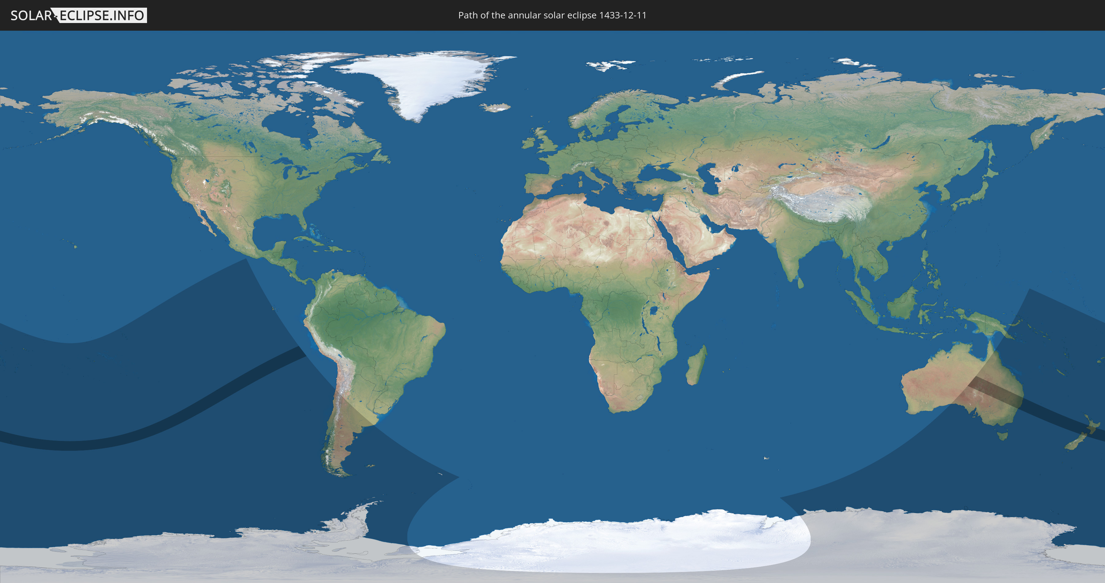
Die Sonnenfinsternis am 11.12.1433 kann man in 27 Ländern als partielle Sonnenfinsternis beobachten.
Der Finsternispfad verläuft durch 3 Länder. Nur in diesen Ländern ist sie als ringförmige Sonnenfinsternis zu sehen.
In den folgenden Ländern ist die Sonnenfinsternis ringförmig zu sehen
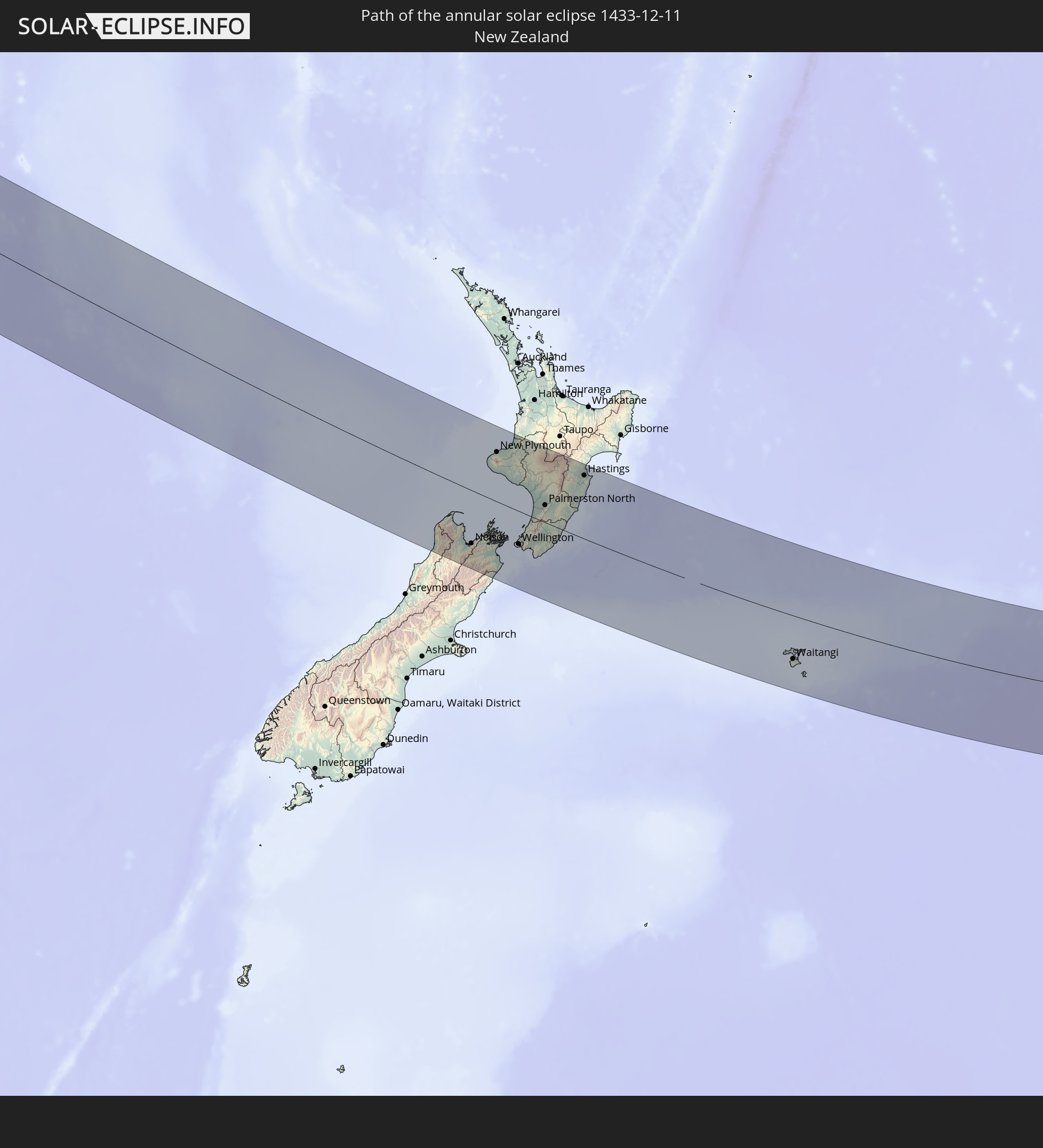 Neuseeland
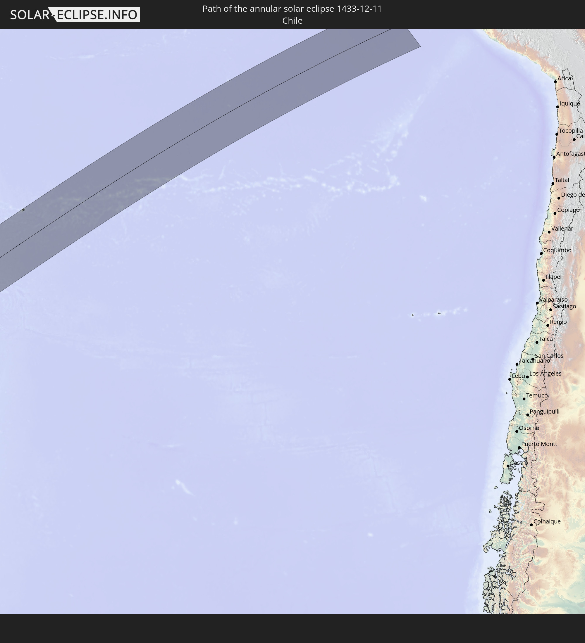 Chile
Chile
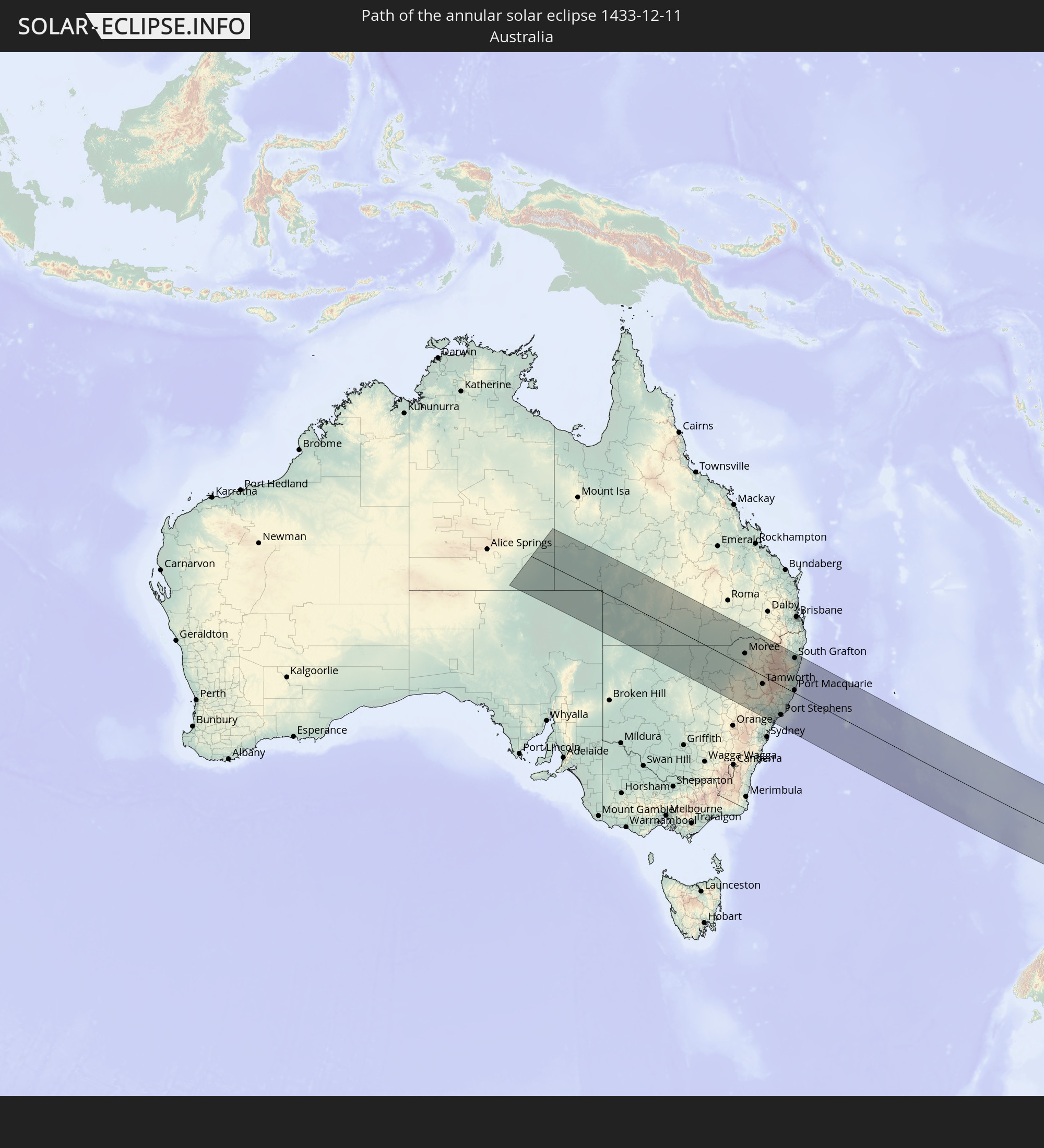 Australien
In den folgenden Ländern ist die Sonnenfinsternis partiell zu sehen
 Fidschi
 Antarktika
 Neuseeland
 Wallis und Futuna
 Tonga
Tonga
 Kiribati
 Samoa
Samoa
 Tokelau
 Amerikanisch-Samoa
 Niue
Niue
 Cookinseln
 Französisch-Polynesien
 Pitcairninseln
 Chile
Chile
 Ecuador
 Argentinien
 Falklandinseln
 Südgeorgien und die Südlichen Sandwichinseln
 Australien
 Föderierte Staaten von Mikronesien
 Papua-Neuguinea
 Salomonen
 Neukaledonien
 Vanuatu
 Nauru
Nauru
 Norfolkinsel
 Tuvalu
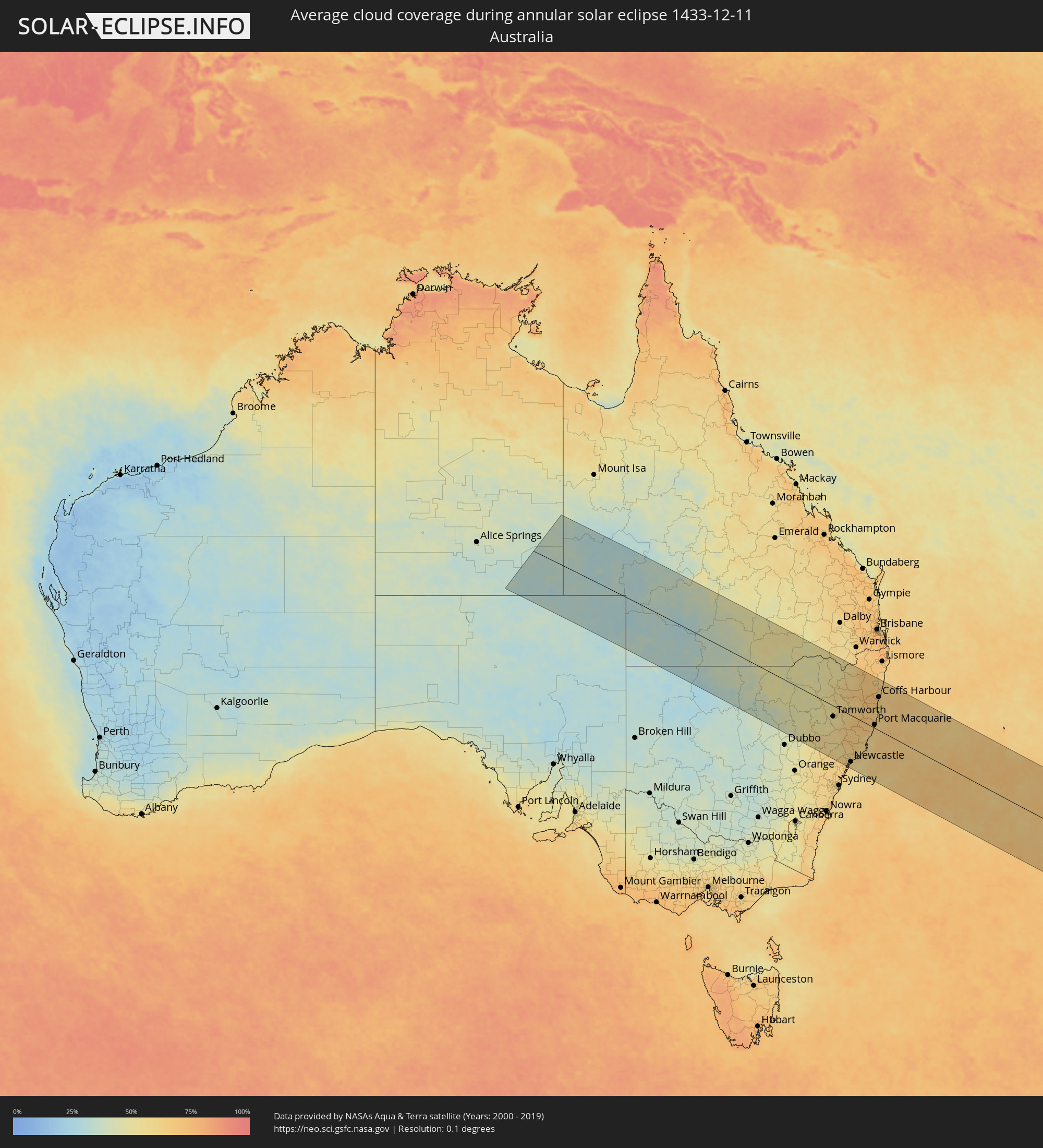
Wie wird das Wetter während der ringförmigen Sonnenfinsternis am 11.12.1433?
Wo ist der beste Ort, um die ringförmige Sonnenfinsternis vom 11.12.1433 zu beobachten?
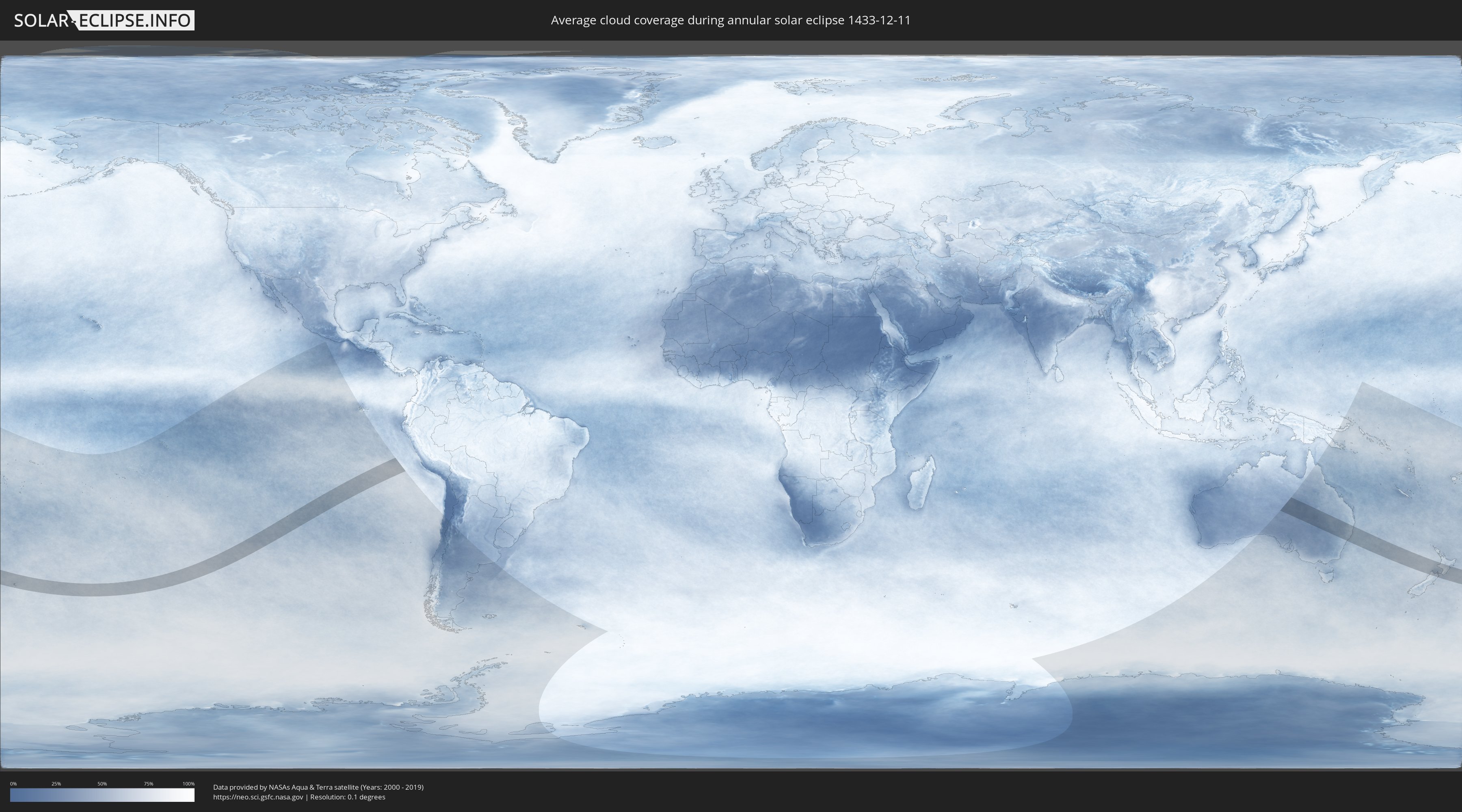
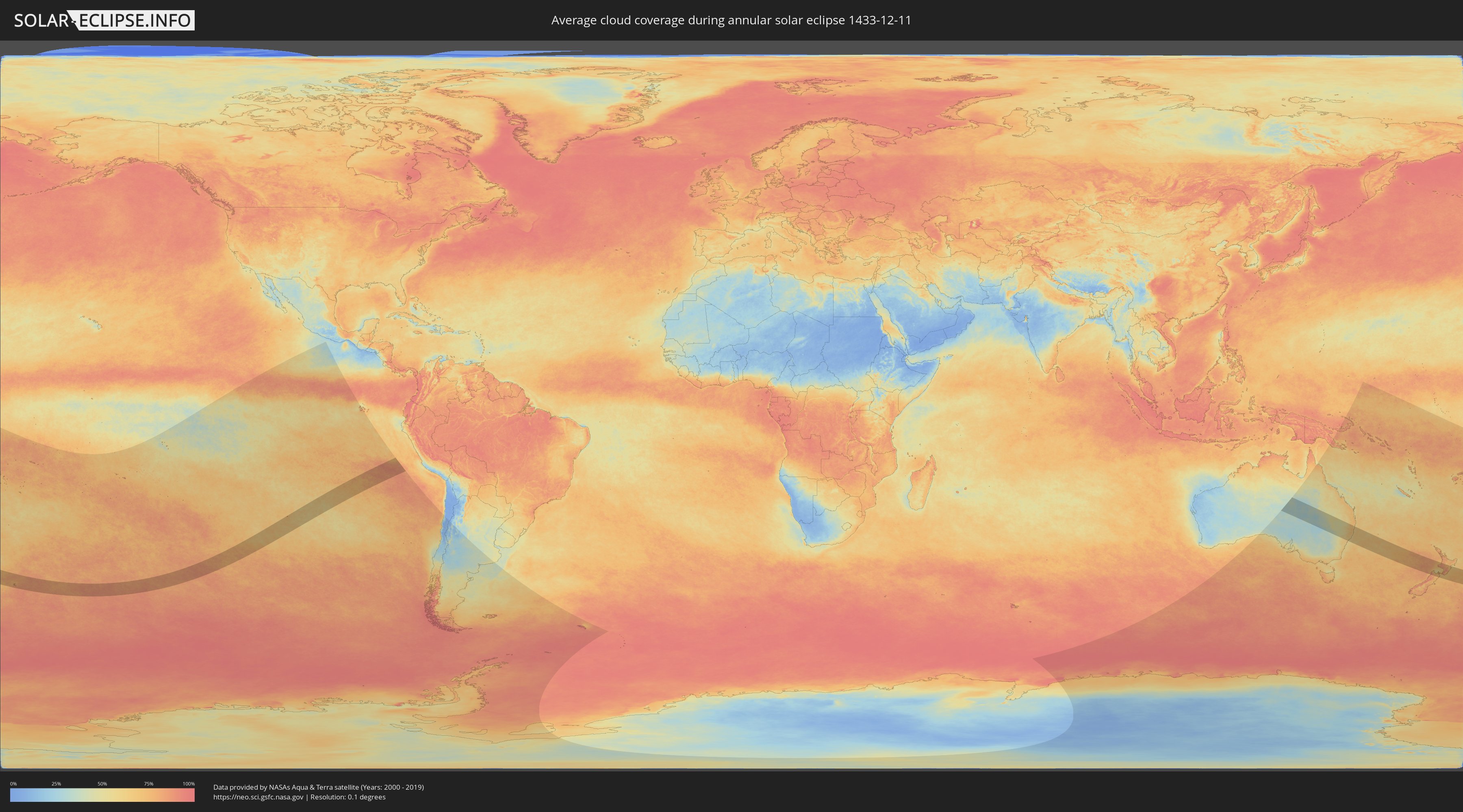
Die folgenden Karten zeigen die durchschnittliche Bewölkung für den Tag, an dem die ringförmige Sonnenfinsternis
stattfindet. Mit Hilfe der Karten lässt sich der Ort entlang des Finsternispfades eingrenzen,
der die besten Aussichen auf einen klaren wolkenfreien Himmel bietet.
Trotzdem muss man immer lokale Gegenenheiten beachten und sollte sich genau über das Wetter an seinem
gewählten Beobachtungsort informieren.
Die Daten stammen von den beiden NASA-Satelliten
AQUA und TERRA
und wurden über einen Zeitraum von 19 Jahren (2000 - 2019) gemittelt.
Detaillierte Länderkarten
 Neuseeland
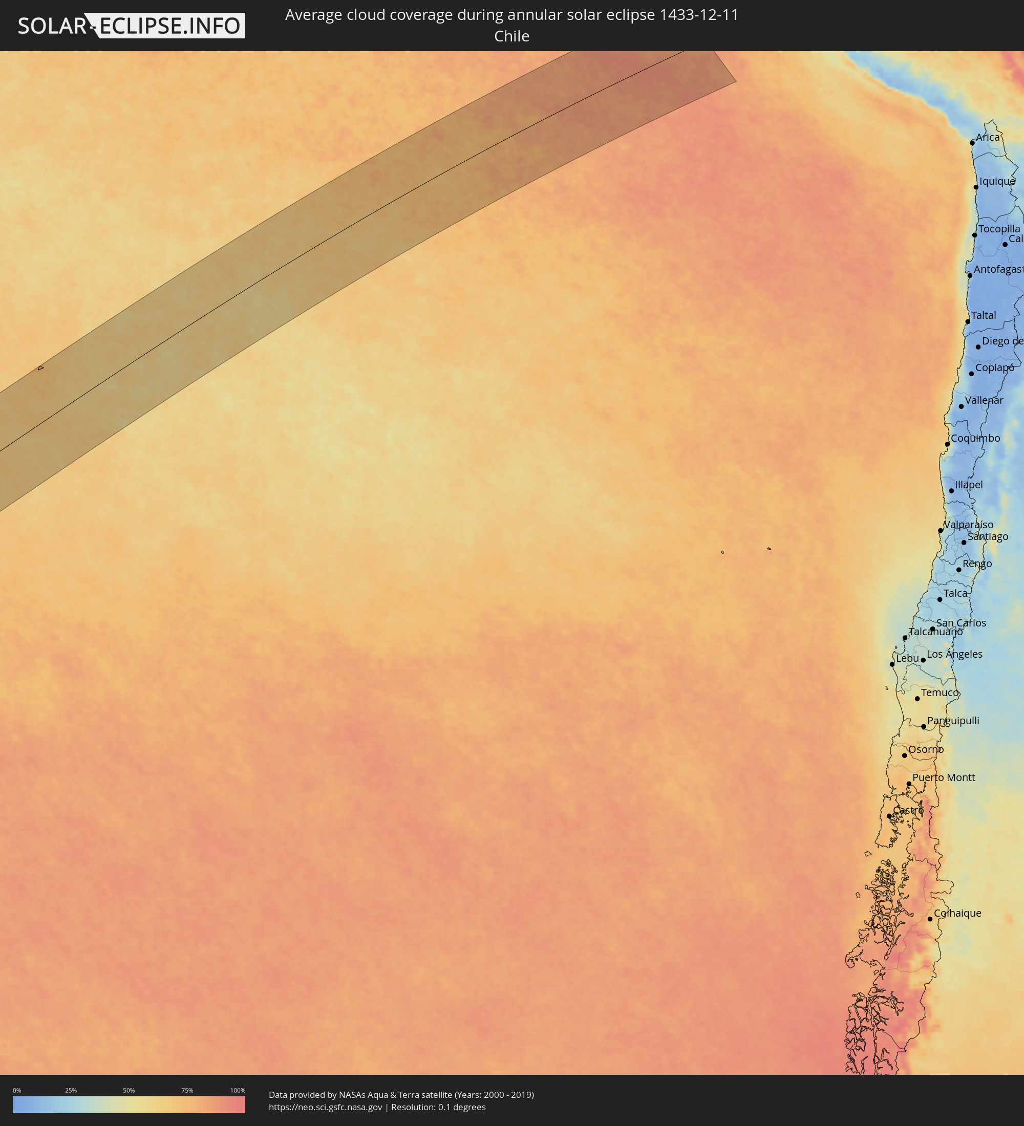 Chile
Chile
 Australien
Orte im Finsternispfad
Die nachfolgene Tabelle zeigt Städte und Orte mit mehr als 5.000 Einwohnern, die sich im Finsternispfad befinden. Städte mit mehr als 100.000 Einwohnern sind dick gekennzeichnet. Mit einem Klick auf den Ort öffnet sich eine Detailkarte die die Lage des jeweiligen Ortes zusammen mit dem Verlauf der zentralen Finsternis präsentiert.
| Ort | Typ | Dauer der Verfinsterung | Ortszeit bei maximaler Verfinsterung | Entfernung zur Zentrallinie | Ø Bewölkung |
|
Waitangi, Chatham Islands
|
ringförmig | - | 09:12:27 UTC+12:15 | 105 km | 85% |
|
Narrabri, New South Wales
|
ringförmig | - | 06:11:52 UTC+10:00 | 20 km | 45% |
|
Moree, New South Wales
|
ringförmig | - | 06:10:49 UTC+10:00 | 68 km | 50% |
|
Gunnedah, New South Wales
|
ringförmig | - | 06:12:41 UTC+10:00 | 63 km | 49% |
|
Goondiwindi, Queensland
|
ringförmig | - | 06:09:45 UTC+10:00 | 179 km | 50% |
|
Muswellbrook, New South Wales
|
ringförmig | - | 06:14:21 UTC+10:00 | 159 km | 55% |
|
South Tamworth, New South Wales
|
ringförmig | - | 06:12:54 UTC+10:00 | 45 km | 49% |
|
Tamworth, New South Wales
|
ringförmig | - | 06:12:52 UTC+10:00 | 43 km | 49% |
|
Inverell, New South Wales
|
ringförmig | - | 06:11:15 UTC+10:00 | 94 km | 59% |
|
Singleton, New South Wales
|
ringförmig | - | 06:14:46 UTC+10:00 | 177 km | 59% |
|
Cessnock, New South Wales
|
ringförmig | - | 06:15:08 UTC+10:00 | 194 km | 62% |
|
Kurri Kurri, New South Wales
|
ringförmig | - | 06:15:08 UTC+10:00 | 187 km | 61% |
|
Rutherford, New South Wales
|
ringförmig | - | 06:15:00 UTC+10:00 | 175 km | 61% |
|
Maitland, New South Wales
|
ringförmig | - | 06:15:02 UTC+10:00 | 175 km | 60% |
|
East Maitland, New South Wales
|
ringförmig | - | 06:15:03 UTC+10:00 | 176 km | 60% |
|
Rathmines, New South Wales
|
ringförmig | - | 06:15:26 UTC+10:00 | 204 km | 64% |
|
Toronto, New South Wales
|
ringförmig | - | 06:15:24 UTC+10:00 | 201 km | 64% |
|
Eleebana, New South Wales
|
ringförmig | - | 06:15:22 UTC+10:00 | 197 km | 64% |
|
Charlestown, New South Wales
|
ringförmig | - | 06:15:20 UTC+10:00 | 192 km | 62% |
|
Belmont North, New South Wales
|
ringförmig | - | 06:15:25 UTC+10:00 | 198 km | 62% |
|
Armidale, New South Wales
|
ringförmig | - | 06:12:12 UTC+10:00 | 48 km | 60% |
|
Elermore Vale, New South Wales
|
ringförmig | - | 06:15:17 UTC+10:00 | 188 km | 62% |
|
Mayfield, New South Wales
|
ringförmig | - | 06:15:16 UTC+10:00 | 183 km | 62% |
|
Glen Innes, New South Wales
|
ringförmig | - | 06:11:15 UTC+10:00 | 127 km | 61% |
|
Raymond Terrace, New South Wales
|
ringförmig | - | 06:15:04 UTC+10:00 | 168 km | 62% |
|
Newcastle, New South Wales
|
ringförmig | - | 06:15:19 UTC+10:00 | 184 km | 61% |
|
Medowie, New South Wales
|
ringförmig | - | 06:15:05 UTC+10:00 | 162 km | 60% |
|
Port Stephens, New South Wales
|
ringförmig | - | 06:15:04 UTC+10:00 | 151 km | 62% |
|
Corlette, New South Wales
|
ringförmig | - | 06:15:05 UTC+10:00 | 149 km | 62% |
|
Nelson Bay, New South Wales
|
ringförmig | - | 06:15:05 UTC+10:00 | 148 km | 62% |
|
Taree, New South Wales
|
ringförmig | - | 06:14:05 UTC+10:00 | 55 km | 59% |
|
Forster, New South Wales
|
ringförmig | - | 06:14:26 UTC+10:00 | 78 km | 66% |
|
Kempsey, New South Wales
|
ringförmig | - | 06:13:04 UTC+10:00 | 44 km | 71% |
|
Port Macquarie, New South Wales
|
ringförmig | - | 06:13:31 UTC+10:00 | 13 km | 62% |
|
South Grafton, New South Wales
|
ringförmig | - | 06:11:21 UTC+10:00 | 183 km | 66% |
|
Grafton, New South Wales
|
ringförmig | - | 06:11:19 UTC+10:00 | 186 km | 66% |
|
Nambucca, New South Wales
|
ringförmig | - | 06:12:31 UTC+10:00 | 94 km | 64% |
|
Nambucca Heads, New South Wales
|
ringförmig | - | 06:12:32 UTC+10:00 | 95 km | 64% |
|
Toormina, New South Wales
|
ringförmig | - | 06:12:11 UTC+10:00 | 127 km | 67% |
|
Coffs Harbour, New South Wales
|
ringförmig | - | 06:12:07 UTC+10:00 | 133 km | 68% |
|
Port Motueka, Tasman
|
ringförmig | - | 08:09:39 UTC+11:30 | 124 km | 67% |
|
Richmond, Tasman
|
ringförmig | - | 08:10:09 UTC+11:30 | 139 km | 73% |
|
Nelson, Nelson
|
ringförmig | - | 08:10:09 UTC+11:30 | 129 km | 75% |
|
Blenheim, Marlborough
|
ringförmig | - | 08:11:16 UTC+11:30 | 131 km | 71% |
|
New Plymouth, Taranaki
|
ringförmig | - | 08:07:37 UTC+11:30 | 123 km | 80% |
|
Waitara, Taranaki
|
ringförmig | - | 08:07:41 UTC+11:30 | 135 km | 73% |
|
Hawera, Taranaki
|
ringförmig | - | 08:08:39 UTC+11:30 | 76 km | 75% |
|
Wellington, Wellington
|
ringförmig | - | 08:11:50 UTC+11:30 | 80 km | 75% |
|
Porirua, Wellington
|
ringförmig | - | 08:11:41 UTC+11:30 | 62 km | 81% |
|
Petone, Wellington
|
ringförmig | - | 08:11:51 UTC+11:30 | 71 km | 81% |
|
Lower Hutt, Wellington
|
ringförmig | - | 08:11:53 UTC+11:30 | 69 km | 81% |
|
Paraparaumu, Wellington
|
ringförmig | - | 08:11:32 UTC+11:30 | 35 km | 83% |
|
Wanganui, Manawatu-Wanganui
|
ringförmig | - | 08:10:04 UTC+11:30 | 67 km | 75% |
|
Upper Hutt, Wellington
|
ringförmig | - | 08:11:55 UTC+11:30 | 56 km | 87% |
|
Otaki, Wellington
|
ringförmig | - | 08:11:27 UTC+11:30 | 14 km | 90% |
|
Levin, Manawatu-Wanganui
|
ringförmig | - | 08:11:24 UTC+11:30 | 3 km | 89% |
|
Palmerston North, Manawatu-Wanganui
|
ringförmig | - | 08:11:23 UTC+11:30 | 43 km | 89% |
|
Masterton, Wellington
|
ringförmig | - | 08:12:22 UTC+11:30 | 18 km | 76% |
|
Hastings, Hawke's Bay
|
ringförmig | - | 08:11:49 UTC+11:30 | 157 km | 69% |
|
Taradale, Hawke's Bay
|
ringförmig | - | 08:11:40 UTC+11:30 | 168 km | 65% |
|
Napier, Hawke's Bay
|
ringförmig | - | 08:11:40 UTC+11:30 | 175 km | 65% |