Totale Sonnenfinsternis vom 07.04.1540
| Wochentag: | Sonntag |
| Maximale Dauer der Verfinsterung: | 00m42s |
| Maximale Breite des Finsternispfades: | 123 km |
| Saroszyklus: | 131 |
| Bedeckungsgrad: | 100% |
| Magnitude: | 1.0115 |
| Gamma: | 0.9462 |
Wo kann man die Sonnenfinsternis vom 07.04.1540 sehen?
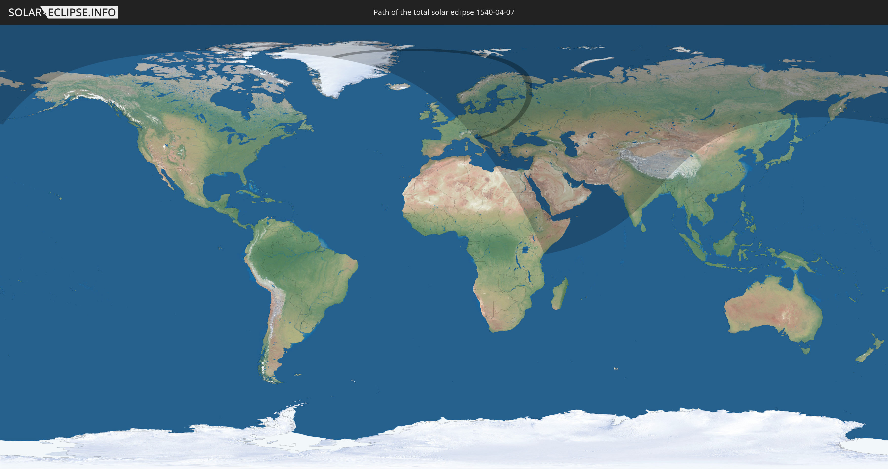
Die Sonnenfinsternis am 07.04.1540 kann man in 77 Ländern als partielle Sonnenfinsternis beobachten.
Der Finsternispfad verläuft durch 11 Länder. Nur in diesen Ländern ist sie als totale Sonnenfinsternis zu sehen.
In den folgenden Ländern ist die Sonnenfinsternis total zu sehen
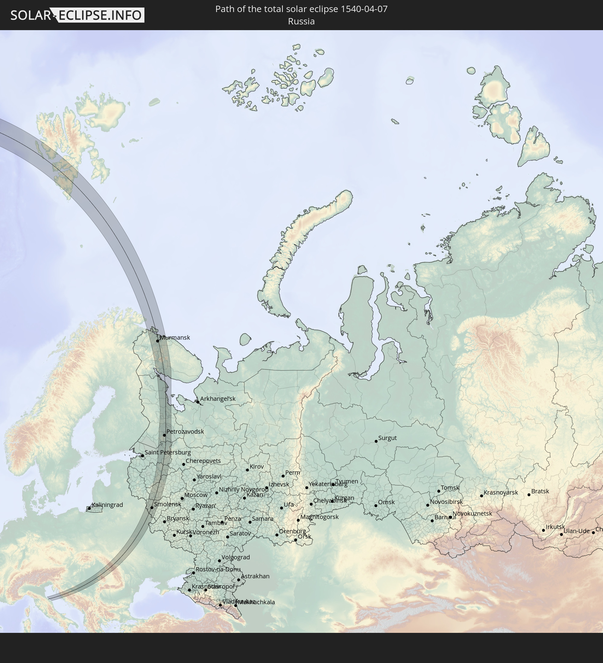 Russland
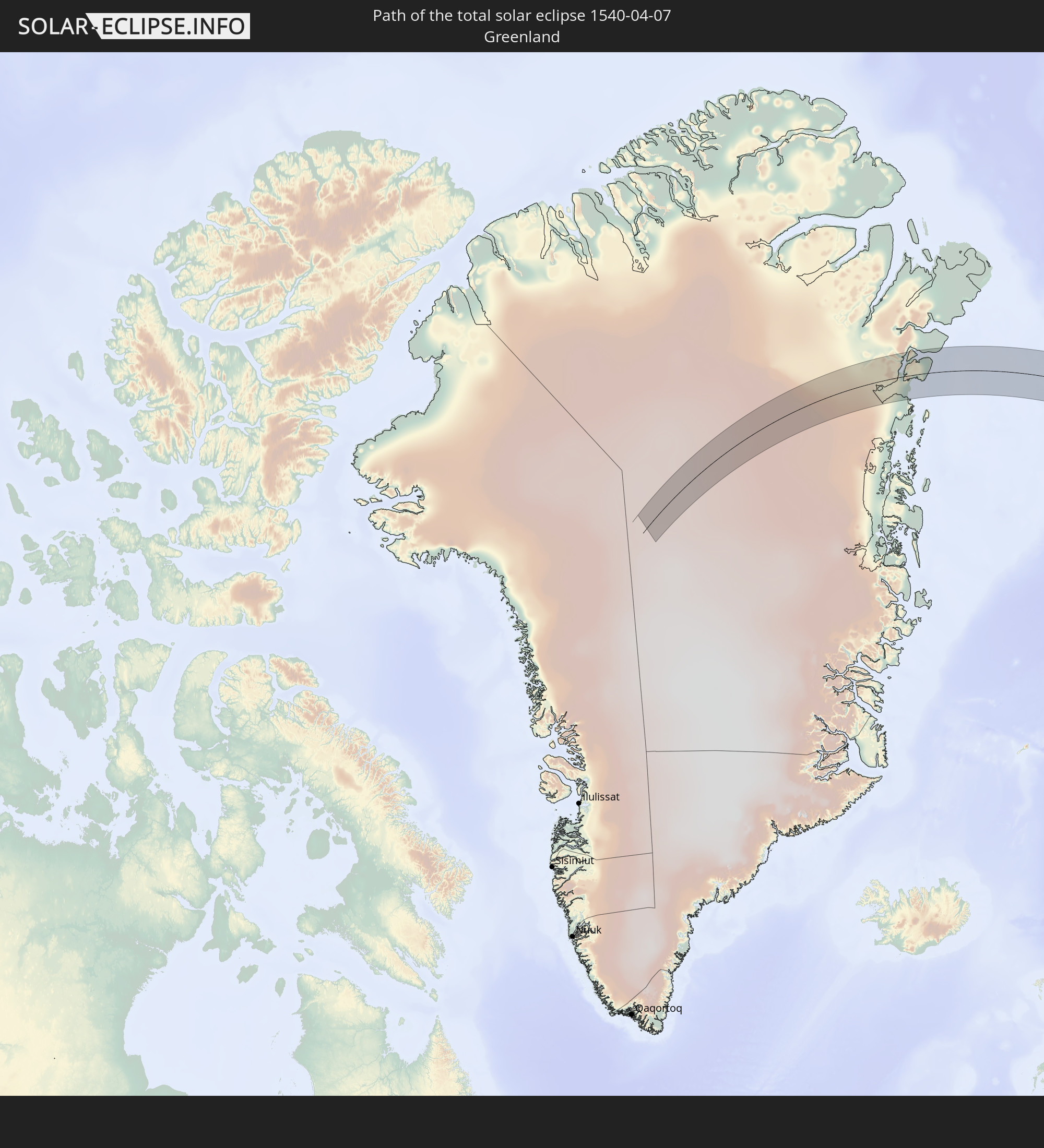 Grönland
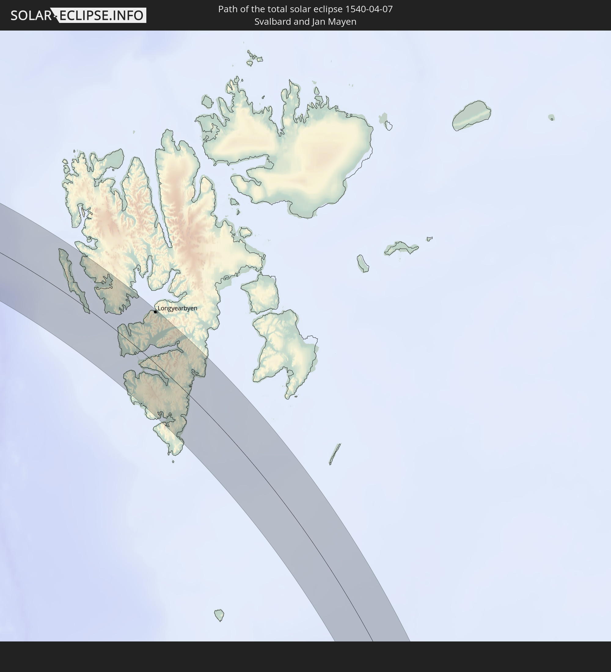 Spitzbergen
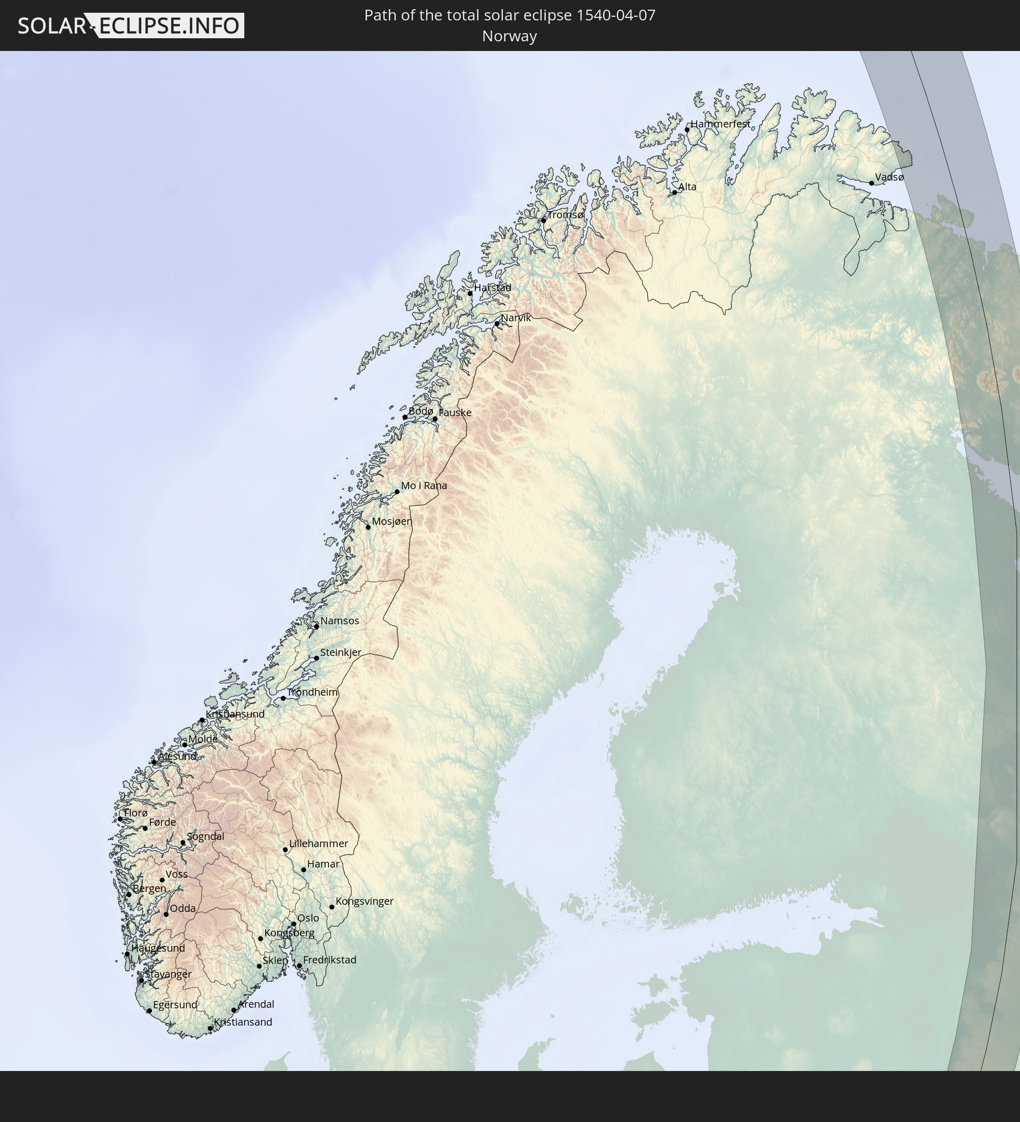 Norwegen
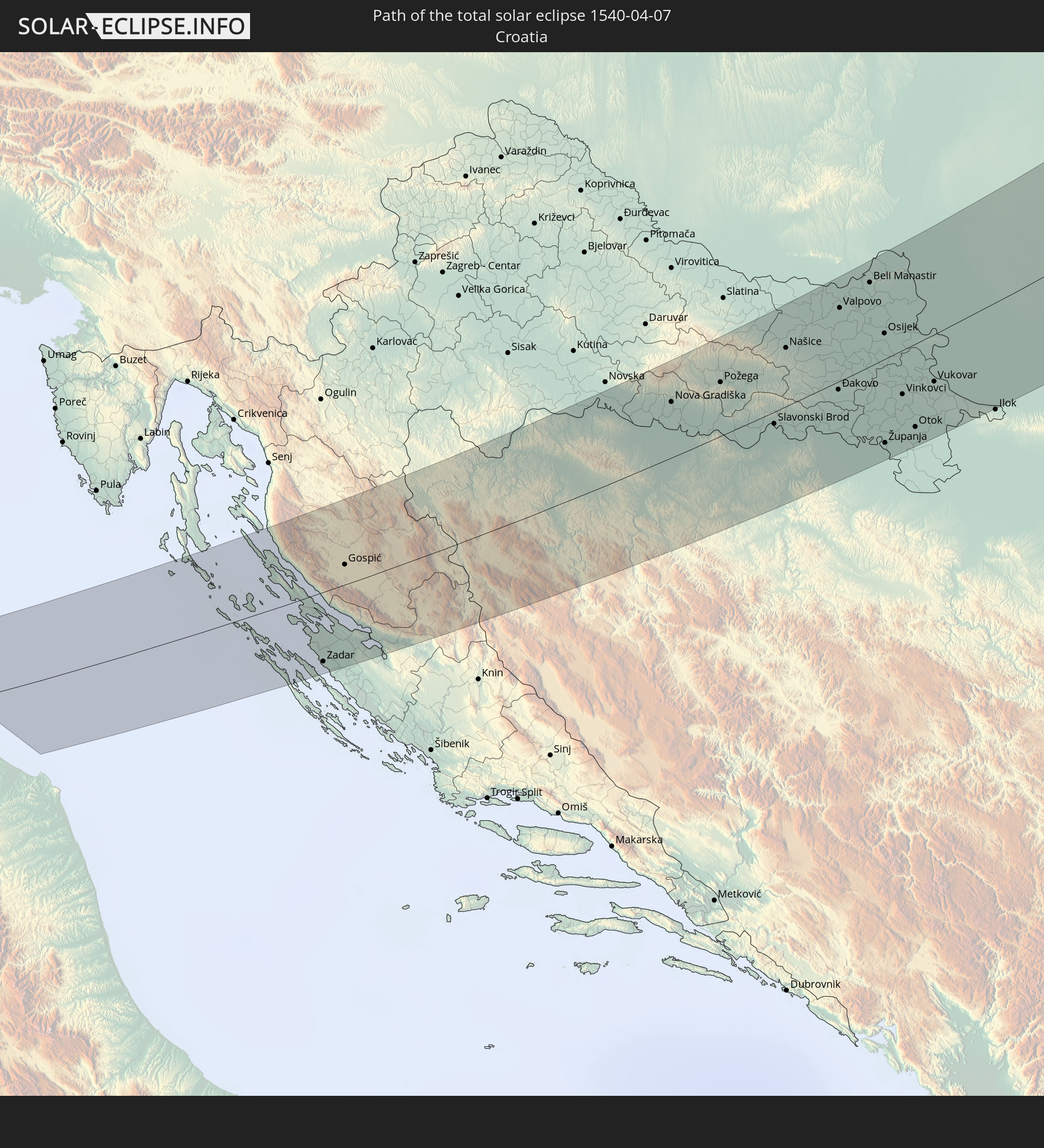 Kroatien
 Bosnien und Herzegowina
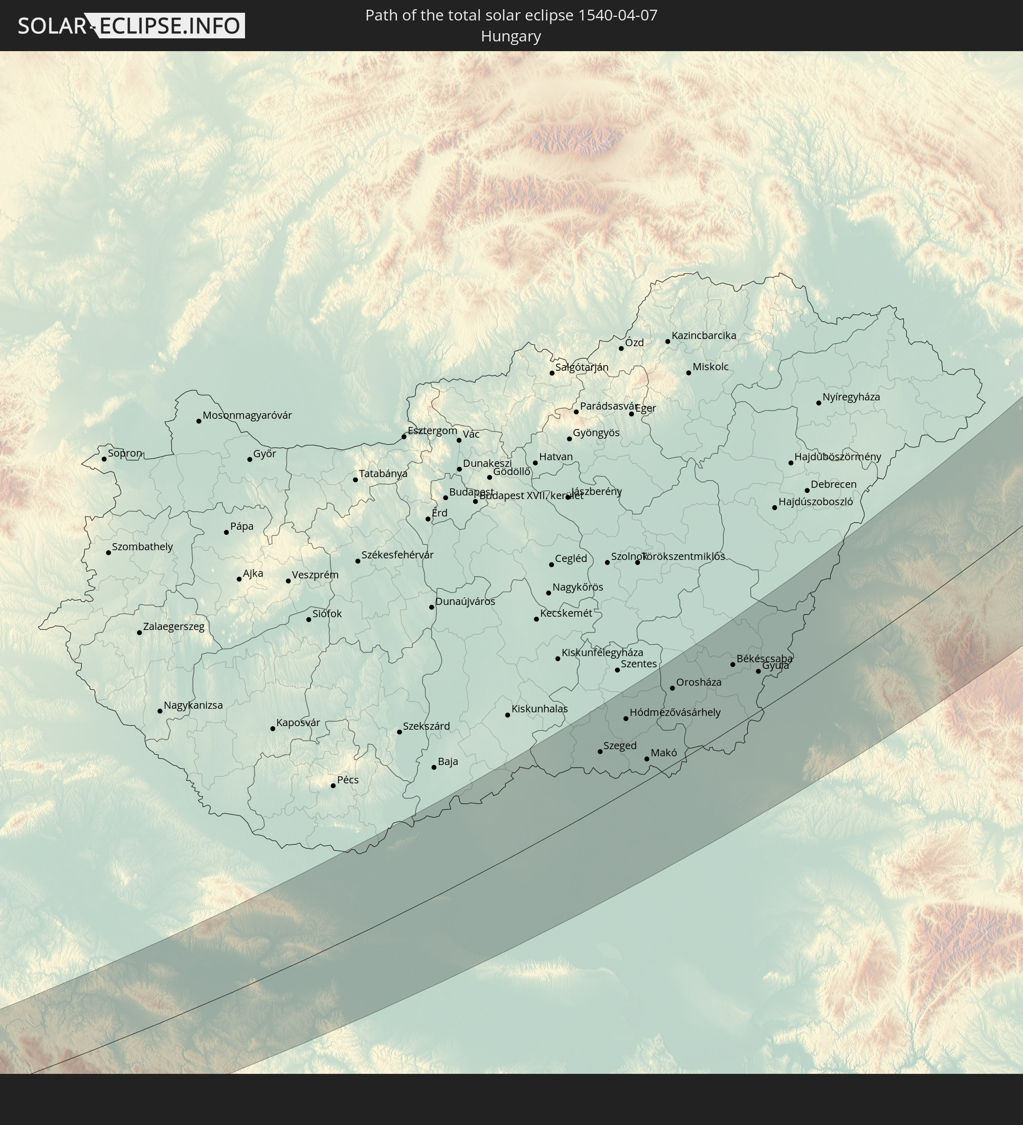 Ungarn
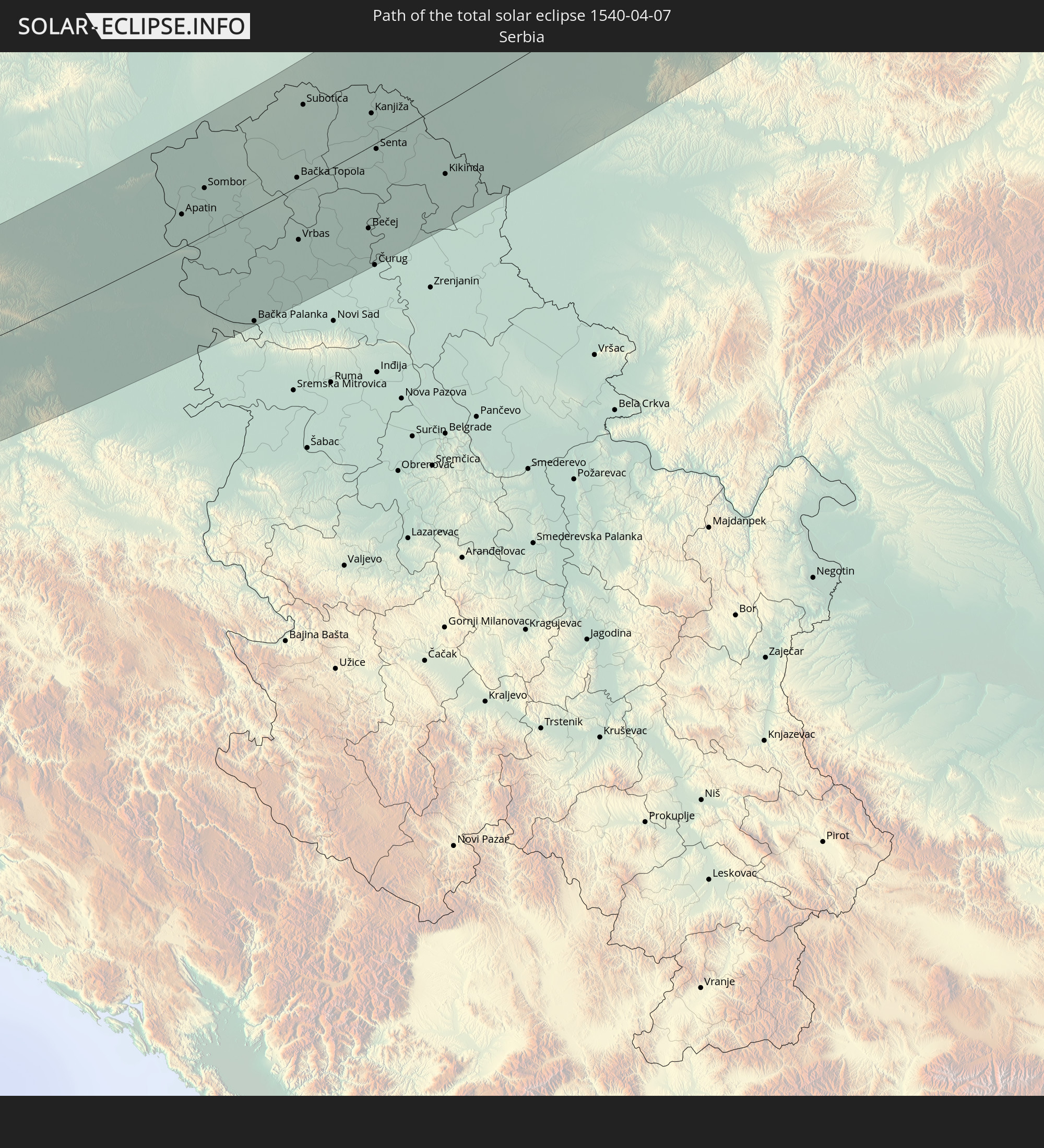 Serbien
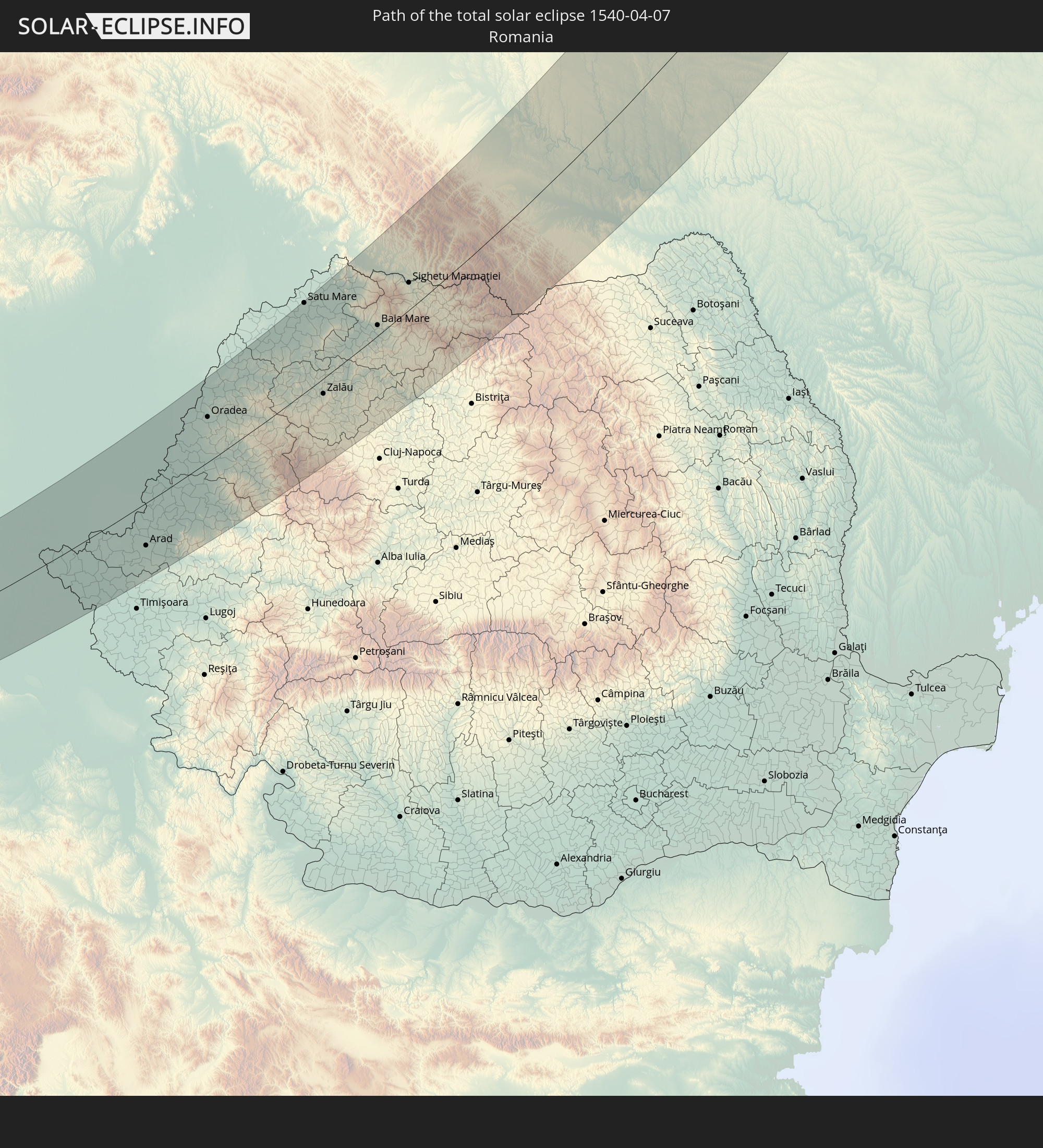 Rumänien
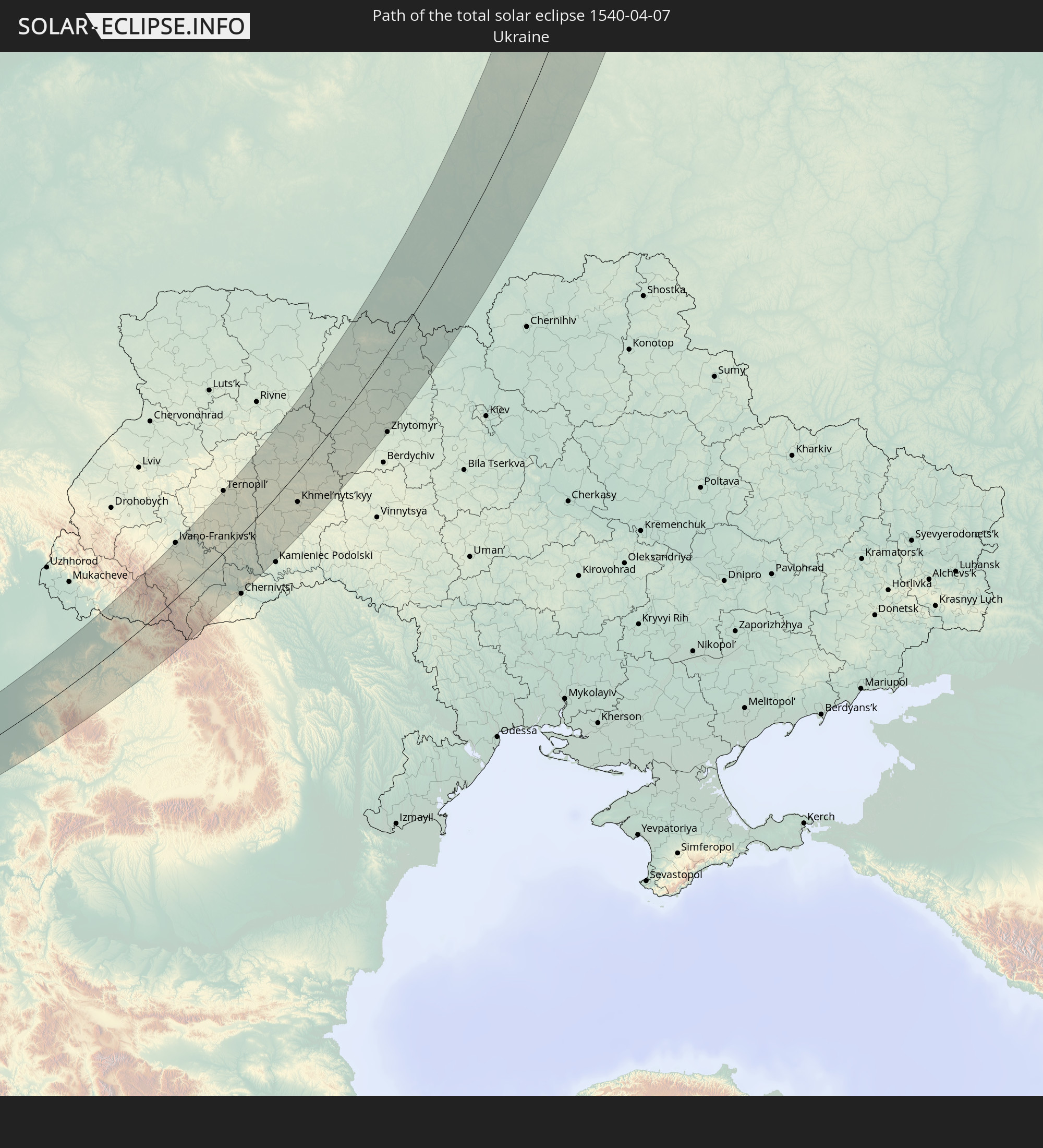 Ukraine
 Weißrussland
In den folgenden Ländern ist die Sonnenfinsternis partiell zu sehen
 Russland
 Vereinigte Staaten
 Kanada
 Grönland
 Spitzbergen
 Vereinigtes Königreich
 Färöer
 Niederlande
 Norwegen
 Deutschland
 Schweiz
 Italien
 Dänemark
 Libyen
 Österreich
 Schweden
 Tschechien
 Slowenien
 Kroatien
 Polen
Polen
 Bosnien und Herzegowina
 Ungarn
 Slowakei
 Montenegro
 Serbien
 Albanien
 Åland Islands
 Griechenland
 Rumänien
 Mazedonien
 Finnland
 Litauen
 Lettland
 Estland
 Sudan
Sudan
 Ukraine
 Bulgarien
 Weißrussland
 Ägypten
 Türkei
 Moldawien
 Republik Zypern
 Äthiopien
 Kenia
Kenia
 Staat Palästina
 Israel
 Saudi-Arabien
 Jordanien
 Libanon
 Syrien
 Eritrea
 Irak
Irak
 Georgien
 Somalia
 Dschibuti
 Jemen
Jemen
 Armenien
 Iran
Iran
 Aserbaidschan
 Kasachstan
 Kuwait
 Bahrain
 Katar
Katar
 Vereinigte Arabische Emirate
 Oman
Oman
 Turkmenistan
 Usbekistan
 Afghanistan
 Pakistan
 Tadschikistan
 Indien
 Kirgisistan
 Volksrepublik China
 Nepal
Nepal
 Mongolei
 Bangladesch
 Bhutan
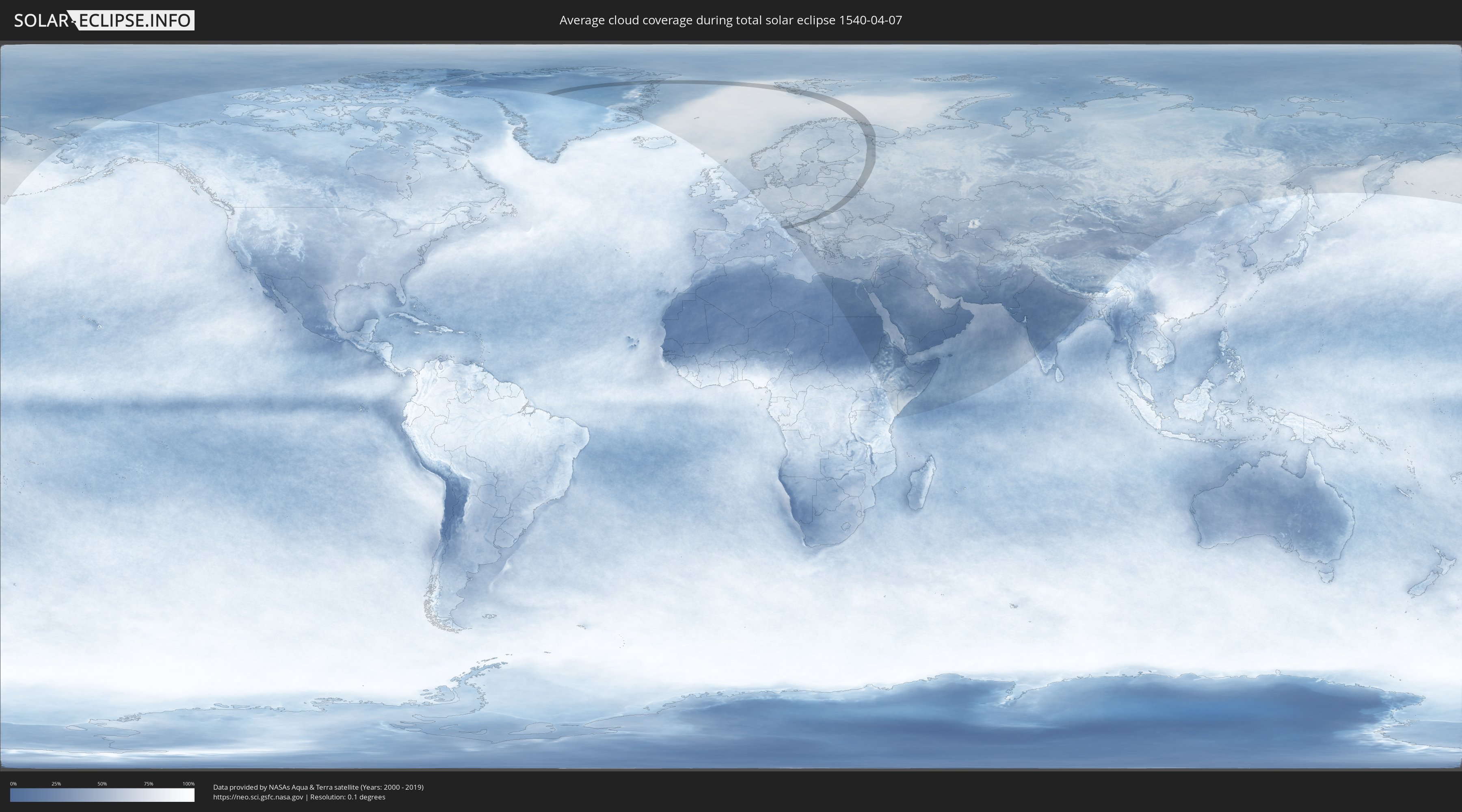
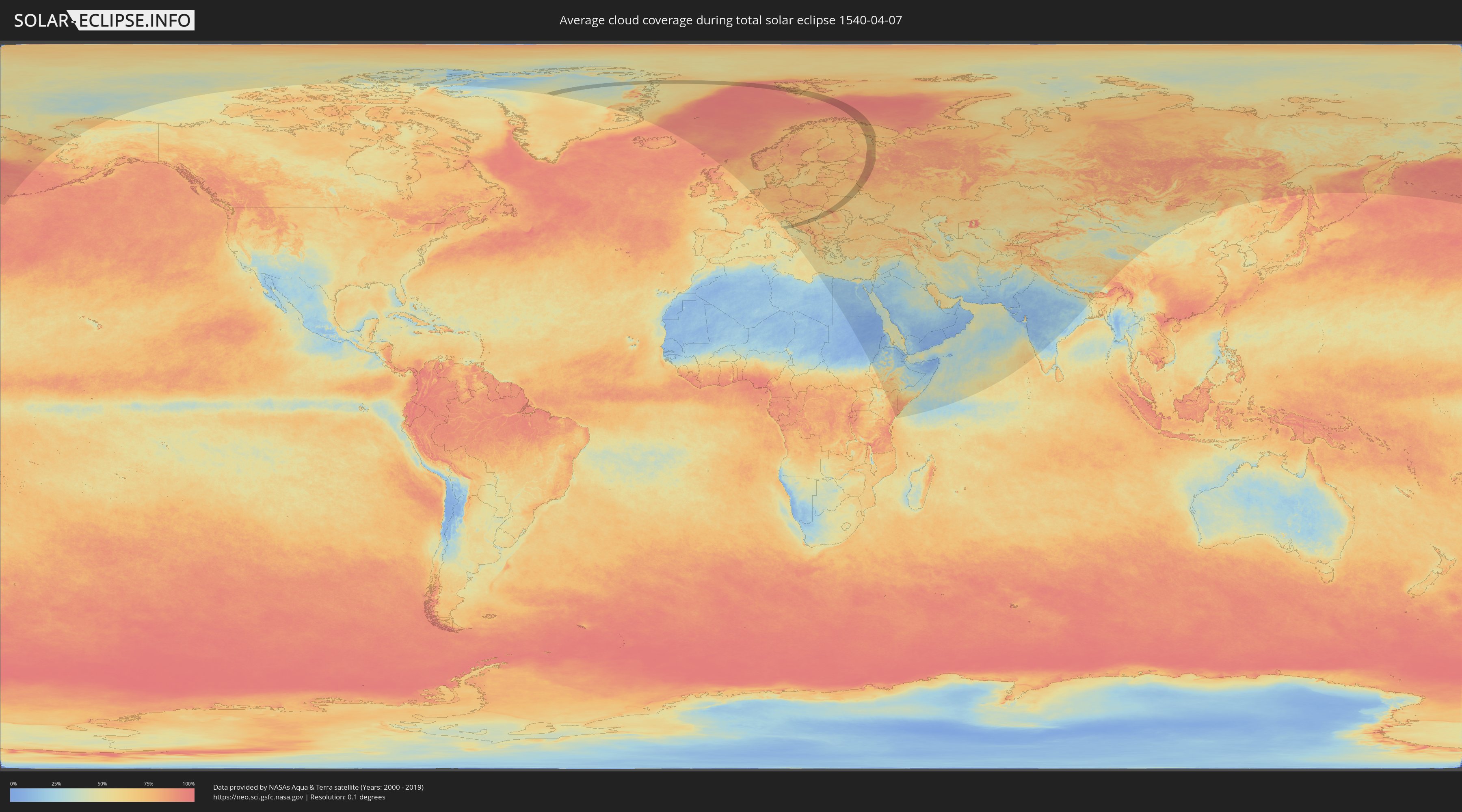
Wie wird das Wetter während der totalen Sonnenfinsternis am 07.04.1540?
Wo ist der beste Ort, um die totale Sonnenfinsternis vom 07.04.1540 zu beobachten?
Die folgenden Karten zeigen die durchschnittliche Bewölkung für den Tag, an dem die totale Sonnenfinsternis
stattfindet. Mit Hilfe der Karten lässt sich der Ort entlang des Finsternispfades eingrenzen,
der die besten Aussichen auf einen klaren wolkenfreien Himmel bietet.
Trotzdem muss man immer lokale Gegenenheiten beachten und sollte sich genau über das Wetter an seinem
gewählten Beobachtungsort informieren.
Die Daten stammen von den beiden NASA-Satelliten
AQUA und TERRA
und wurden über einen Zeitraum von 19 Jahren (2000 - 2019) gemittelt.
Detaillierte Länderkarten
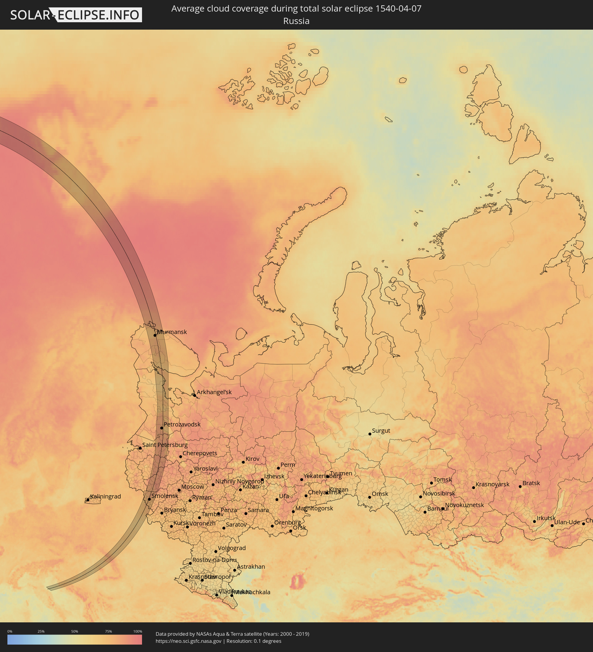 Russland
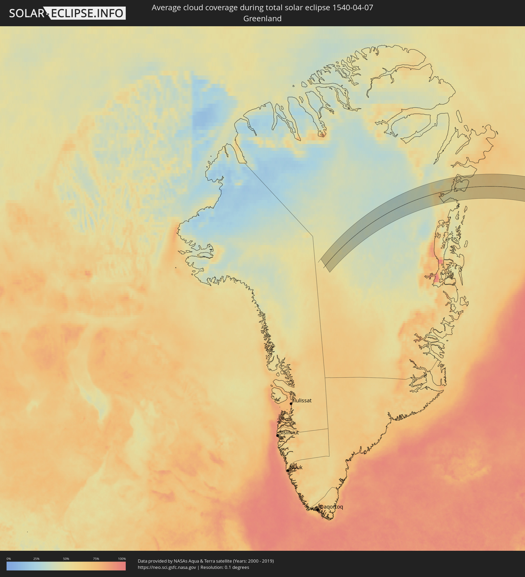 Grönland
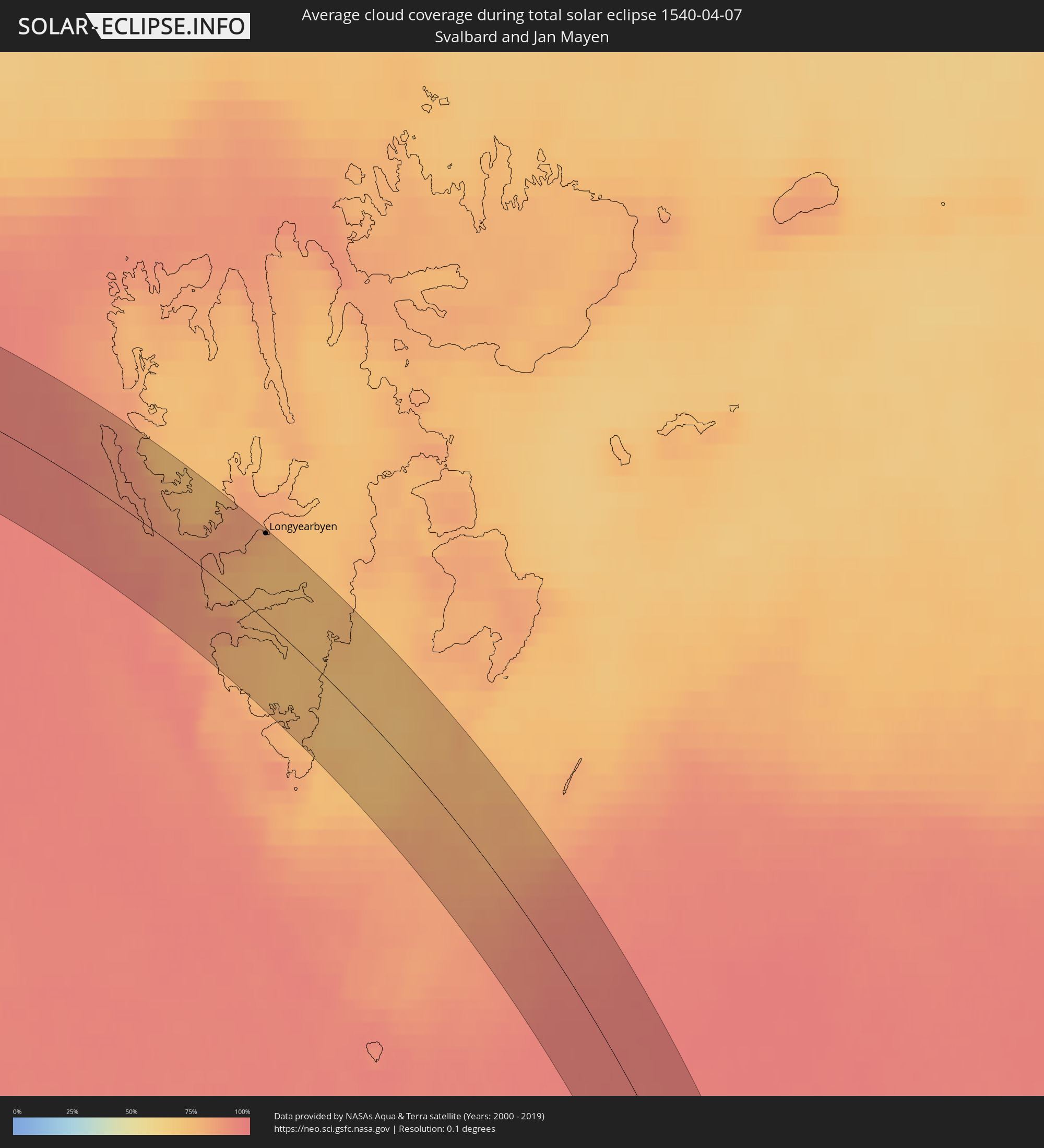 Spitzbergen
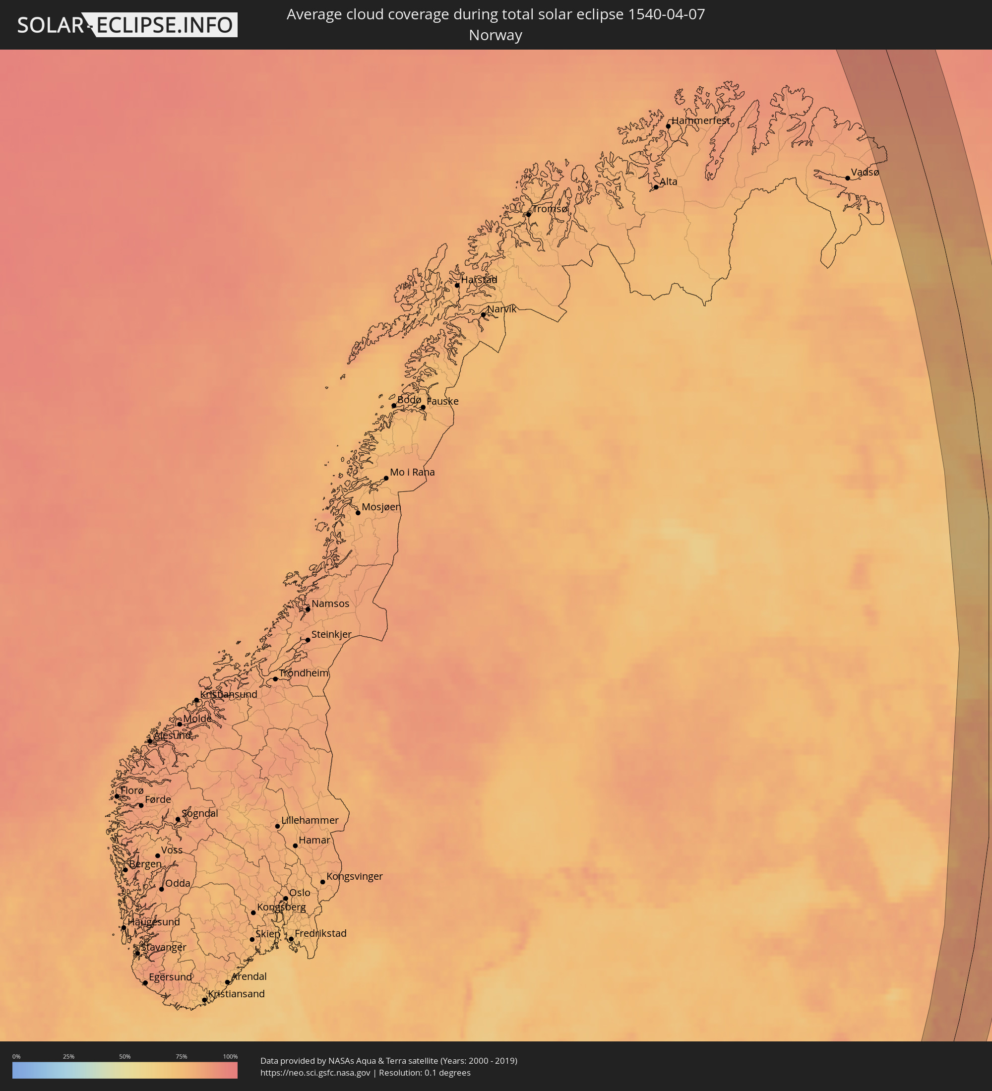 Norwegen
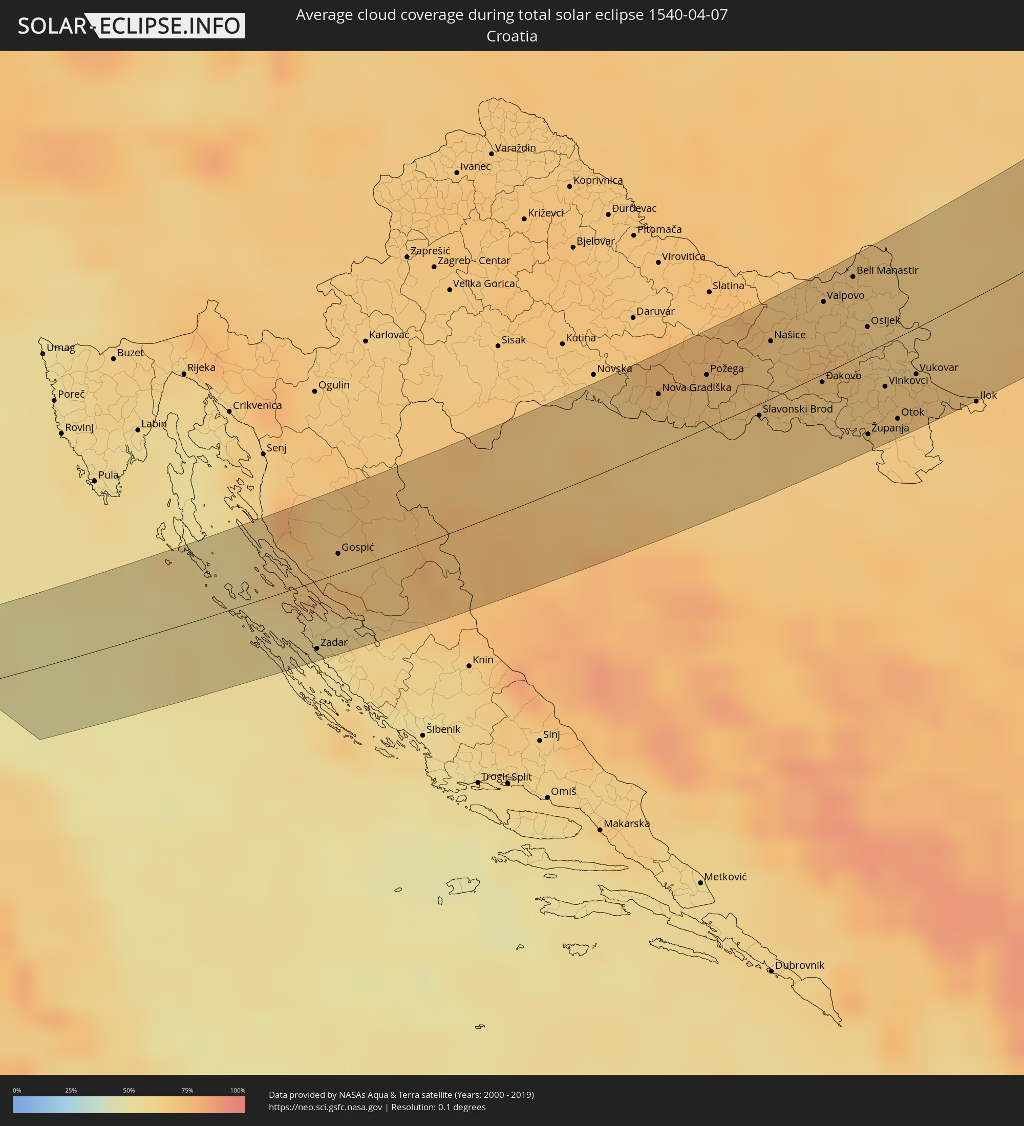 Kroatien
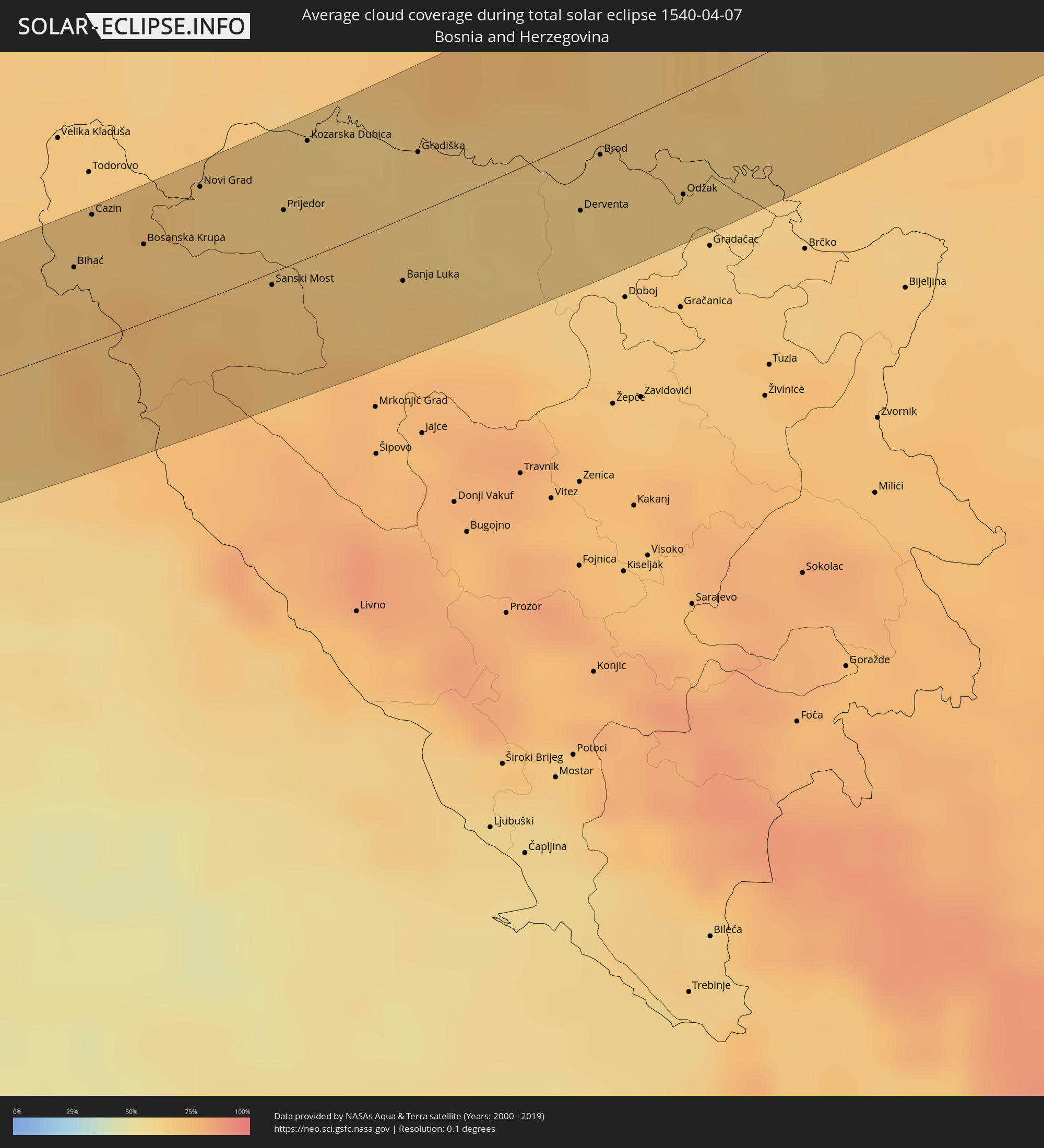 Bosnien und Herzegowina
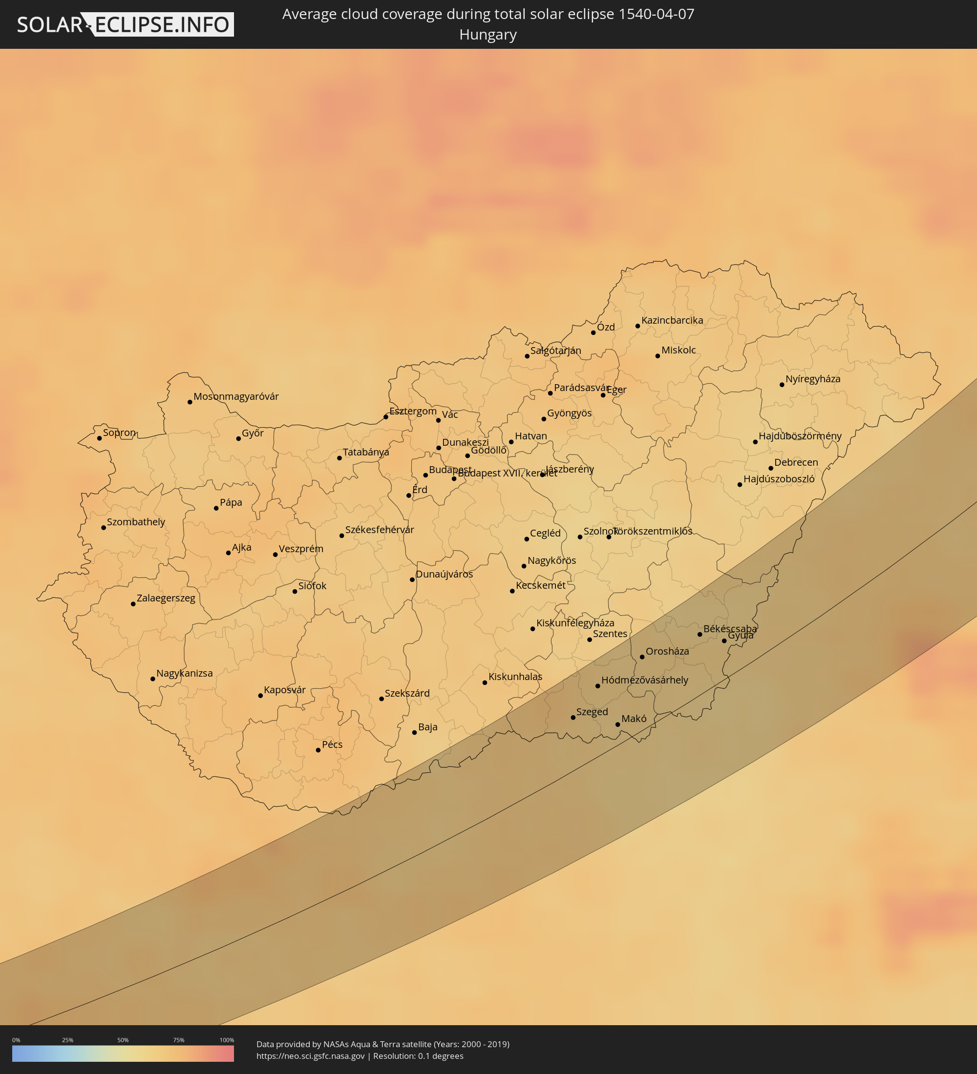 Ungarn
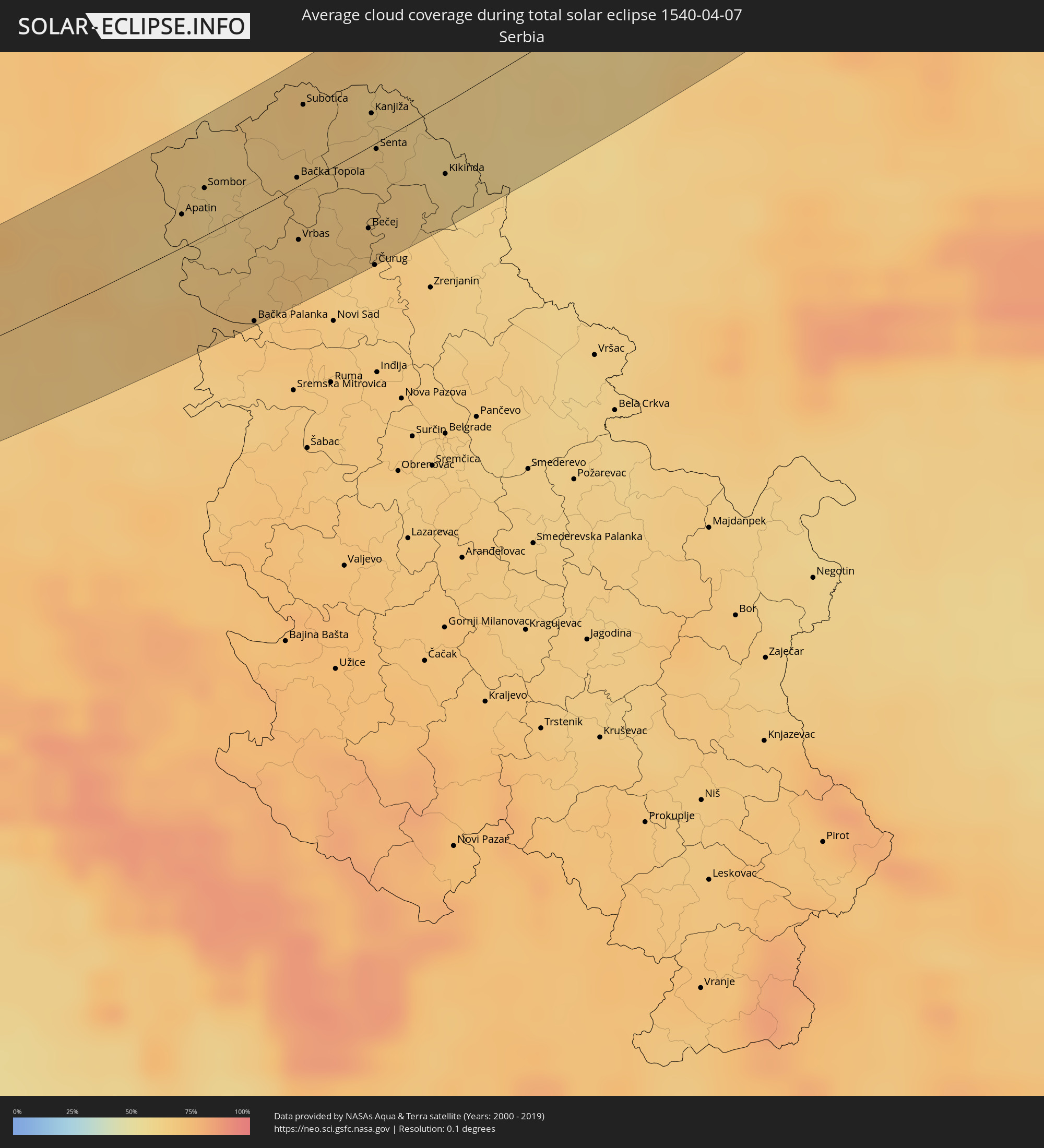 Serbien
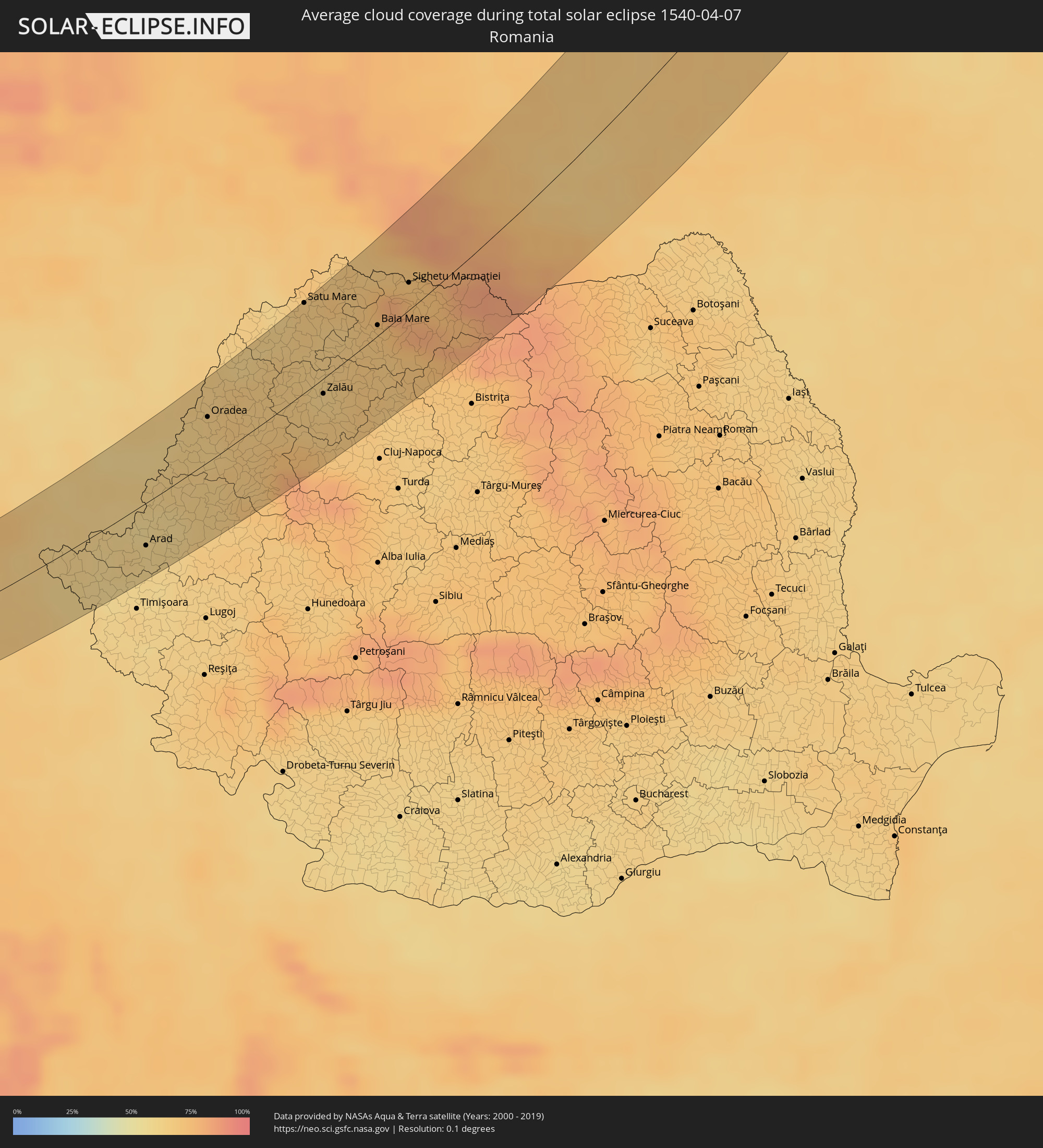 Rumänien
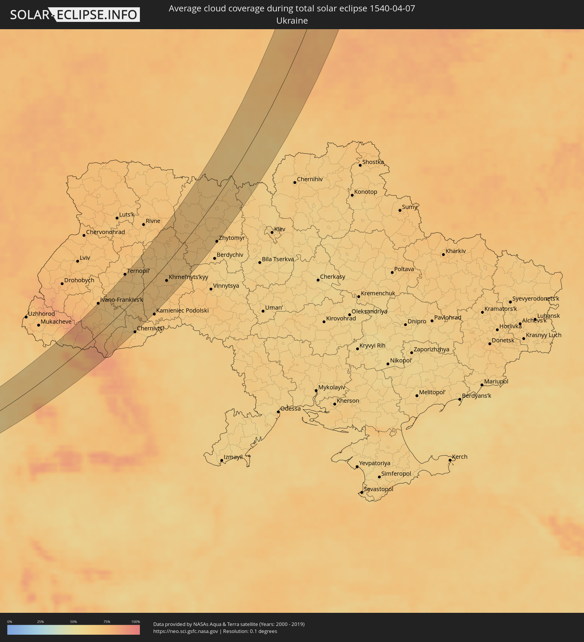 Ukraine
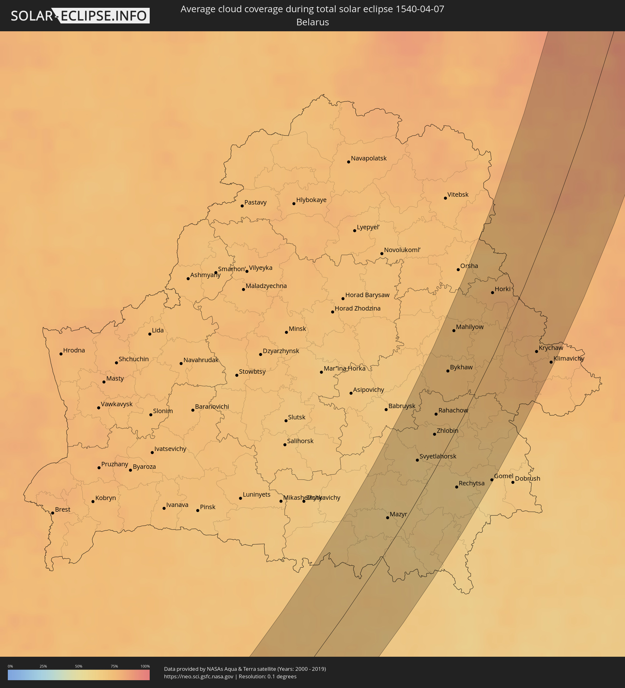 Weißrussland
Orte im Finsternispfad
Die nachfolgene Tabelle zeigt Städte und Orte mit mehr als 5.000 Einwohnern, die sich im Finsternispfad befinden. Städte mit mehr als 100.000 Einwohnern sind dick gekennzeichnet. Mit einem Klick auf den Ort öffnet sich eine Detailkarte die die Lage des jeweiligen Ortes zusammen mit dem Verlauf der zentralen Finsternis präsentiert.
| Ort | Typ | Dauer der Verfinsterung | Ortszeit bei maximaler Verfinsterung | Entfernung zur Zentrallinie | Ø Bewölkung |
|
Zadar, Zadarska
|
total | - | 05:27:10 UTC+01:00 | 32 km | 56% |
|
Gospić, Ličko-Senjska
|
total | - | 05:27:50 UTC+01:00 | 9 km | 73% |
|
Longyearbyen, Svalbard
|
total | - | 06:28:38 UTC+01:00 | 48 km | 78% |
|
Bihać, Federation of Bosnia and Herzegovina
|
total | - | 05:28:10 UTC+01:00 | 24 km | 70% |
|
Cazin, Federation of Bosnia and Herzegovina
|
total | - | 05:28:24 UTC+01:00 | 38 km | 69% |
|
Stijena, Federation of Bosnia and Herzegovina
|
total | - | 05:28:19 UTC+01:00 | 32 km | 70% |
|
Bosanska Krupa, Federation of Bosnia and Herzegovina
|
total | - | 05:28:12 UTC+01:00 | 23 km | 69% |
|
Otoka, Federation of Bosnia and Herzegovina
|
total | - | 05:28:20 UTC+01:00 | 30 km | 67% |
|
Novi Grad, Republic of Srspka
|
total | - | 05:28:25 UTC+01:00 | 34 km | 67% |
|
Sanica, Federation of Bosnia and Herzegovina
|
total | - | 05:27:38 UTC+01:00 | 19 km | 73% |
|
Sanski Most, Federation of Bosnia and Herzegovina
|
total | - | 05:27:53 UTC+01:00 | 4 km | 69% |
|
Prijedor, Republic of Srspka
|
total | - | 05:28:14 UTC+01:00 | 17 km | 66% |
|
Ključ, Federation of Bosnia and Herzegovina
|
total | - | 05:27:28 UTC+01:00 | 31 km | 75% |
|
Kozarska Dubica, Republic of Srspka
|
total | - | 05:28:33 UTC+01:00 | 34 km | 65% |
|
Omarska, Republic of Srspka
|
total | - | 05:28:03 UTC+01:00 | 2 km | 67% |
|
Banja Luka, Republic of Srspka
|
total | - | 05:27:47 UTC+01:00 | 18 km | 69% |
|
Trn, Republic of Srspka
|
total | - | 05:27:55 UTC+01:00 | 11 km | 67% |
|
Gradiška, Republic of Srspka
|
total | - | 05:28:24 UTC+01:00 | 17 km | 65% |
|
Laktaši, Republic of Srspka
|
total | - | 05:27:59 UTC+01:00 | 8 km | 66% |
|
Čelinac, Republic of Srspka
|
total | - | 05:27:40 UTC+01:00 | 28 km | 73% |
|
Nova Gradiška, Slavonski Brod-Posavina
|
total | - | 05:28:33 UTC+01:00 | 25 km | 68% |
|
Srbac, Republic of Srspka
|
total | - | 05:28:15 UTC+01:00 | 4 km | 65% |
|
Prnjavor, Republic of Srspka
|
total | - | 05:27:51 UTC+01:00 | 23 km | 64% |
|
Požega, Požeško-Slavonska
|
total | - | 05:28:38 UTC+01:00 | 24 km | 68% |
|
Kalenderovci Donji, Republic of Srspka
|
total | - | 05:27:56 UTC+01:00 | 21 km | 65% |
|
Derventa, Republic of Srspka
|
total | - | 05:27:59 UTC+01:00 | 20 km | 65% |
|
Brod, Republic of Srspka
|
total | - | 05:28:14 UTC+01:00 | 7 km | 65% |
|
Slavonski Brod, Slavonski Brod-Posavina
|
total | - | 05:28:16 UTC+01:00 | 5 km | 65% |
|
Našice, Osječko-Baranjska
|
total | - | 05:28:48 UTC+01:00 | 25 km | 67% |
|
Odžak, Federation of Bosnia and Herzegovina
|
total | - | 05:27:58 UTC+01:00 | 29 km | 65% |
|
Belišće, Osječko-Baranjska
|
total | - | 05:29:04 UTC+01:00 | 34 km | 69% |
|
Đakovo, Osječko-Baranjska
|
total | - | 05:28:26 UTC+01:00 | 3 km | 65% |
|
Valpovo, Osječko-Baranjska
|
total | - | 05:29:02 UTC+01:00 | 32 km | 69% |
|
Čepin, Osječko-Baranjska
|
total | - | 05:28:46 UTC+01:00 | 13 km | 67% |
|
Beli Manastir, Osječko-Baranjska
|
total | - | 05:29:11 UTC+01:00 | 36 km | 67% |
|
Višnjevac, Osječko-Baranjska
|
total | - | 05:28:50 UTC+01:00 | 16 km | 66% |
|
Ivankovo, Vukovar-Sirmium
|
total | - | 05:28:21 UTC+01:00 | 15 km | 68% |
|
Osijek, Osječko-Baranjska
|
total | - | 05:28:48 UTC+01:00 | 11 km | 64% |
|
Županja, Vukovar-Sirmium
|
total | - | 05:27:59 UTC+01:00 | 36 km | 65% |
|
Darda, Osječko-Baranjska
|
total | - | 05:28:56 UTC+01:00 | 19 km | 64% |
|
Tenja, Osječko-Baranjska
|
total | - | 05:28:42 UTC+01:00 | 4 km | 65% |
|
Vinkovci, Vukovar-Sirmium
|
total | - | 05:28:20 UTC+01:00 | 19 km | 68% |
|
Otok, Vukovar-Sirmium
|
total | - | 05:28:04 UTC+01:00 | 36 km | 67% |
|
Borovo, Vukovar-Sirmium
|
total | - | 05:28:27 UTC+01:00 | 16 km | 69% |
|
Apatin, Vojvodina
|
total | - | 05:28:57 UTC+01:00 | 13 km | 65% |
|
Vukovar, Vukovar-Sirmium
|
total | - | 05:28:23 UTC+01:00 | 20 km | 70% |
|
Prigrevica
|
total | - | 05:28:56 UTC+01:00 | 10 km | 63% |
|
Sonta
|
total | - | 05:28:48 UTC+01:00 | 1 km | 64% |
|
Sombor, Vojvodina
|
total | - | 05:29:06 UTC+01:00 | 18 km | 62% |
|
Stanišić
|
total | - | 05:29:23 UTC+01:00 | 33 km | 64% |
|
Bácsalmás, Bács-Kiskun
|
total | - | 05:29:40 UTC+01:00 | 45 km | 67% |
|
Bačka Palanka, Vojvodina
|
total | - | 05:28:09 UTC+01:00 | 43 km | 69% |
|
Bački Petrovac, Vojvodina
|
total | - | 05:28:18 UTC+01:00 | 40 km | 69% |
|
Bačka Topola, Vojvodina
|
total | - | 05:29:05 UTC+01:00 | 3 km | 67% |
|
Vrbas, Vojvodina
|
total | - | 05:28:40 UTC+01:00 | 21 km | 67% |
|
Subotica, Vojvodina
|
total | - | 05:29:34 UTC+01:00 | 30 km | 67% |
|
Mórahalom, Csongrád
|
total | - | 05:29:44 UTC+01:00 | 33 km | 66% |
|
Bačko Gradište
|
total | - | 05:28:32 UTC+01:00 | 39 km | 66% |
|
Bečej, Vojvodina
|
total | - | 05:28:40 UTC+01:00 | 31 km | 67% |
|
Kanjiža, Vojvodina
|
total | - | 05:29:27 UTC+01:00 | 12 km | 63% |
|
Čurug
|
total | - | 05:28:25 UTC+01:00 | 46 km | 67% |
|
Senta, Vojvodina
|
total | - | 05:29:12 UTC+01:00 | 2 km | 65% |
|
Bačko Petrovo Selo
|
total | - | 05:28:49 UTC+01:00 | 24 km | 66% |
|
Sándorfalva, Csongrád
|
total | - | 05:29:57 UTC+01:00 | 39 km | 67% |
|
Novi Kneževac, Vojvodina
|
total | - | 05:29:25 UTC+01:00 | 9 km | 63% |
|
Mol
|
total | - | 05:28:55 UTC+01:00 | 20 km | 66% |
|
Čoka, Vojvodina
|
total | - | 05:29:13 UTC+01:00 | 3 km | 65% |
|
Szeged, Csongrád
|
total | - | 05:29:45 UTC+01:00 | 26 km | 65% |
|
Novo Miloševo
|
total | - | 05:28:49 UTC+01:00 | 31 km | 65% |
|
Hódmezővásárhely, Csongrád
|
total | - | 05:30:01 UTC+01:00 | 35 km | 63% |
|
Mokrin
|
total | - | 05:29:10 UTC+01:00 | 15 km | 62% |
|
Kikinda, Vojvodina
|
total | - | 05:28:58 UTC+01:00 | 27 km | 62% |
|
Makó, Csongrád
|
total | - | 05:29:39 UTC+01:00 | 10 km | 62% |
|
Sânnicolau Mare, Timiş
|
total | - | 06:13:47 UTC+01:44 | 9 km | 61% |
|
Orosháza, Bekes
|
total | - | 05:30:14 UTC+01:00 | 36 km | 63% |
|
Nagyszénás, Bekes
|
total | - | 05:30:26 UTC+01:00 | 47 km | 64% |
|
Srpska Crnja
|
total | - | 05:28:46 UTC+01:00 | 46 km | 62% |
|
Jimbolia, Timiş
|
total | - | 06:13:16 UTC+01:44 | 40 km | 62% |
|
Tótkomlós, Bekes
|
total | - | 05:29:57 UTC+01:00 | 19 km | 62% |
|
Kondoros, Bekes
|
total | - | 05:30:34 UTC+01:00 | 49 km | 62% |
|
Mezőhegyes, Bekes
|
total | - | 05:29:46 UTC+01:00 | 6 km | 61% |
|
Csorvás, Bekes
|
total | - | 05:30:19 UTC+01:00 | 35 km | 63% |
|
Mezőkovácsháza, Bekes
|
total | - | 05:29:54 UTC+01:00 | 10 km | 62% |
|
Battonya, Bekes
|
total | - | 05:29:41 UTC+01:00 | 5 km | 61% |
|
Mezőberény, Bekes
|
total | - | 05:30:37 UTC+01:00 | 44 km | 61% |
|
Újkígyós, Bekes
|
total | - | 05:30:12 UTC+01:00 | 22 km | 62% |
|
Pecica, Arad
|
total | - | 06:13:52 UTC+01:44 | 18 km | 63% |
|
Békéscsaba, Bekes
|
total | - | 05:30:22 UTC+01:00 | 29 km | 63% |
|
Békés, Bekes
|
total | - | 05:30:31 UTC+01:00 | 35 km | 61% |
|
Elek, Bekes
|
total | - | 05:30:05 UTC+01:00 | 9 km | 60% |
|
Vésztő, Bekes
|
total | - | 05:30:46 UTC+01:00 | 44 km | 60% |
|
Gyula, Bekes
|
total | - | 05:30:17 UTC+01:00 | 18 km | 63% |
|
Curtici, Arad
|
total | - | 06:14:10 UTC+01:44 | 11 km | 59% |
|
Arad, Arad
|
total | - | 06:13:52 UTC+01:44 | 27 km | 60% |
|
Sarkad, Bekes
|
total | - | 05:30:27 UTC+01:00 | 23 km | 62% |
|
Sântana, Arad
|
total | - | 06:14:08 UTC+01:44 | 19 km | 59% |
|
Komádi, Hajdú-Bihar
|
total | - | 05:30:53 UTC+01:00 | 41 km | 61% |
|
Salonta, Bihor
|
total | - | 06:14:54 UTC+01:44 | 17 km | 65% |
|
Ineu, Arad
|
total | - | 06:14:14 UTC+01:44 | 25 km | 64% |
|
Oradea, Bihor
|
total | - | 06:15:19 UTC+01:44 | 28 km | 63% |
|
Marghita, Bihor
|
total | - | 06:15:48 UTC+01:44 | 37 km | 66% |
|
Beiuş, Bihor
|
total | - | 06:14:35 UTC+01:44 | 26 km | 68% |
|
Aleşd, Bihor
|
total | - | 06:15:17 UTC+01:44 | 8 km | 66% |
|
Şimleu Silvaniei, Sălaj
|
total | - | 06:15:33 UTC+01:44 | 5 km | 67% |
|
Satu Mare, Satu Mare
|
total | - | 06:16:33 UTC+01:44 | 52 km | 67% |
|
Zalău, Sălaj
|
total | - | 06:15:28 UTC+01:44 | 9 km | 65% |
|
Jibou, Sălaj
|
total | - | 06:15:33 UTC+01:44 | 13 km | 68% |
|
Seini, Maramureş
|
total | - | 06:16:26 UTC+01:44 | 28 km | 68% |
|
Negreşti-Oaş, Satu Mare
|
total | - | 06:16:37 UTC+01:44 | 31 km | 69% |
|
Baia Mare, Satu Mare
|
total | - | 06:16:14 UTC+01:44 | 6 km | 71% |
|
Dej, Cluj
|
total | - | 06:15:18 UTC+01:44 | 51 km | 67% |
|
Sighetu Marmaţiei, Maramureş
|
total | - | 06:16:42 UTC+01:44 | 15 km | 73% |
|
Rakhiv, Zakarpattia
|
total | - | 06:34:34 UTC+02:02 | 10 km | 79% |
|
Vişeu de Sus, Maramureş
|
total | - | 06:16:17 UTC+01:44 | 30 km | 77% |
|
Nadvirna, Ivano-Frankivsk
|
total | - | 06:35:36 UTC+02:02 | 40 km | 72% |
|
Borşa, Maramureş
|
total | - | 06:16:09 UTC+01:44 | 46 km | 82% |
|
Ivano-Frankivs’k, Ivano-Frankivsk
|
total | - | 06:36:07 UTC+02:02 | 56 km | 71% |
|
Kolomyya, Ivano-Frankivsk
|
total | - | 06:35:23 UTC+02:02 | 8 km | 71% |
|
Buchach, Ternopil
|
total | - | 06:36:21 UTC+02:02 | 32 km | 67% |
|
Ternopil’, Ternopil
|
total | - | 06:37:15 UTC+02:02 | 58 km | 70% |
|
Terebovlya, Ternopil
|
total | - | 06:36:47 UTC+02:02 | 33 km | 68% |
|
Zbarazh, Ternopil
|
total | - | 06:37:26 UTC+02:02 | 57 km | 70% |
|
Chortkiv, Ternopil
|
total | - | 06:36:15 UTC+02:02 | 7 km | 66% |
|
Horodok, Khmelnytskyi
|
total | - | 06:36:30 UTC+02:02 | 24 km | 70% |
|
Netishyn, Khmelnytskyi
|
total | - | 06:38:41 UTC+02:02 | 58 km | 71% |
|
Izyaslav, Khmelnytskyi
|
total | - | 06:38:16 UTC+02:02 | 33 km | 68% |
|
Slavuta, Khmelnytskyi
|
total | - | 06:38:36 UTC+02:02 | 43 km | 71% |
|
Krasyliv, Khmelnytskyi
|
total | - | 06:37:24 UTC+02:02 | 9 km | 68% |
|
Khmel’nyts’kyy, Khmelnytskyi
|
total | - | 06:36:59 UTC+02:02 | 27 km | 69% |
|
Shepetivka, Khmelnytskyi
|
total | - | 06:38:24 UTC+02:02 | 24 km | 69% |
|
Starokostyantyniv, Khmelnytskyi
|
total | - | 06:37:36 UTC+02:02 | 14 km | 67% |
|
Polonne, Khmelnytskyi
|
total | - | 06:38:17 UTC+02:02 | 5 km | 69% |
|
Novohrad-Volyns’kyy, Zhytomyr
|
total | - | 06:39:10 UTC+02:02 | 21 km | 70% |
|
Baranovka, Zhytomyr
|
total | - | 06:38:36 UTC+02:02 | 1 km | 69% |
|
Korosten’, Zhytomyr
|
total | - | 06:39:52 UTC+02:02 | 13 km | 66% |
|
Ovruch, Zhytomyr
|
total | - | 06:40:34 UTC+02:02 | 1 km | 68% |
|
Malyn, Zhytomyr
|
total | - | 06:39:33 UTC+02:02 | 59 km | 65% |
|
Mazyr, Gomel
|
total | - | 06:29:54 UTC+01:50 | 18 km | 64% |
|
Kalinkavichy, Gomel
|
total | - | 06:30:03 UTC+01:50 | 18 km | 63% |
|
Svyetlahorsk, Gomel
|
total | - | 06:31:02 UTC+01:50 | 22 km | 63% |
|
Khoyniki, Gomel
|
total | - | 06:29:38 UTC+01:50 | 33 km | 65% |
|
Zhlobin, Gomel
|
total | - | 06:31:33 UTC+01:50 | 18 km | 67% |
|
Rahachow, Gomel
|
total | - | 06:31:56 UTC+01:50 | 27 km | 68% |
|
Bykhaw, Mogilev
|
total | - | 06:32:46 UTC+01:50 | 37 km | 72% |
|
Mahilyow, Mogilev
|
total | - | 06:33:32 UTC+01:50 | 50 km | 70% |
|
Rechytsa, Gomel
|
total | - | 06:30:34 UTC+01:50 | 32 km | 62% |
|
Dubrowna, Vitebsk
|
total | - | 06:34:49 UTC+01:50 | 58 km | 70% |
|
Kastsyukowka, Gomel
|
total | - | 06:30:57 UTC+01:50 | 53 km | 65% |
|
Chachersk, Gomel
|
total | - | 06:31:40 UTC+01:50 | 33 km | 66% |
|
Chavusy, Mogilev
|
total | - | 06:33:23 UTC+01:50 | 7 km | 73% |
|
Gomel, Gomel
|
total | - | 06:30:45 UTC+01:50 | 62 km | 63% |
|
Horki, Mogilev
|
total | - | 06:34:18 UTC+01:50 | 28 km | 77% |
|
Slawharad, Mogilev
|
total | - | 06:32:41 UTC+01:50 | 12 km | 74% |
|
Cherykaw, Mogilev
|
total | - | 06:32:58 UTC+01:50 | 28 km | 76% |
|
Krasnapollye, Mogilev
|
total | - | 06:32:31 UTC+01:50 | 41 km | 74% |
|
Krychaw, Mogilev
|
total | - | 06:33:17 UTC+01:50 | 42 km | 77% |
|
Mstsislaw, Mogilev
|
total | - | 06:33:52 UTC+01:50 | 28 km | 76% |
|
Klimavichy, Mogilev
|
total | - | 06:33:06 UTC+01:50 | 61 km | 75% |
|
Smolensk, Smolensk
|
total | - | 07:15:39 UTC+02:30 | 14 km | 75% |
|
Yartsevo, Smolensk
|
total | - | 07:16:17 UTC+02:30 | 41 km | 77% |
|
Nelidovo, Tverskaya
|
total | - | 07:18:32 UTC+02:30 | 4 km | 82% |
|
Murmashi, Murmansk
|
total | - | 07:42:46 UTC+02:30 | 18 km | 78% |
|
Monchegorsk, Murmansk
|
total | - | 07:41:07 UTC+02:30 | 36 km | 76% |
|
Murmansk, Murmansk
|
total | - | 07:43:07 UTC+02:30 | 3 km | 76% |
|
Ostashkov, Tverskaya
|
total | - | 07:20:23 UTC+02:30 | 5 km | 84% |
|
Valday, Novgorod
|
total | - | 07:22:00 UTC+02:30 | 18 km | 83% |
|
Olenegorsk, Murmansk
|
total | - | 07:41:34 UTC+02:30 | 16 km | 81% |
|
Gadzhiyevo, Murmansk
|
total | - | 07:43:41 UTC+02:30 | 13 km | 76% |
|
Apatity, Murmansk
|
total | - | 07:40:30 UTC+02:30 | 22 km | 76% |
|
Severomorsk, Murmansk
|
total | - | 07:43:21 UTC+02:30 | 11 km | 76% |
|
Tikhvin, Leningradskaya Oblast'
|
total | - | 07:25:17 UTC+02:30 | 35 km | 82% |
|
Lodeynoye Pole, Leningradskaya Oblast'
|
total | - | 07:27:23 UTC+02:30 | 48 km | 82% |
|
Boksitogorsk, Leningradskaya Oblast'
|
total | - | 07:25:01 UTC+02:30 | 14 km | 85% |
|
Borovichi, Novgorod
|
total | - | 07:22:55 UTC+02:30 | 11 km | 81% |
|
Bologoye, Tverskaya
|
total | - | 07:21:58 UTC+02:30 | 33 km | 83% |
|
Pikalëvo, Leningradskaya Oblast'
|
total | - | 07:25:09 UTC+02:30 | 3 km | 85% |
|
Podporozh’ye, Leningradskaya Oblast'
|
total | - | 07:27:51 UTC+02:30 | 17 km | 84% |
|
Kondopoga, Republic of Karelia
|
total | - | 07:30:23 UTC+02:30 | 141 km | 79% |
|
Segezha, Republic of Karelia
|
total | - | 07:33:21 UTC+02:30 | 9 km | 71% |
|
Petrozavodsk, Republic of Karelia
|
total | - | 07:29:35 UTC+02:30 | 94 km | 80% |
|
Medvezh’yegorsk, Republic of Karelia
|
total | - | 07:31:47 UTC+02:30 | 5 km | 79% |