Totale Sonnenfinsternis vom 30.01.1767
| Wochentag: | Freitag |
| Maximale Dauer der Verfinsterung: | 04m06s |
| Maximale Breite des Finsternispfades: | 157 km |
| Saroszyklus: | 127 |
| Bedeckungsgrad: | 100% |
| Magnitude: | 1.0471 |
| Gamma: | 0.019 |
Wo kann man die Sonnenfinsternis vom 30.01.1767 sehen?
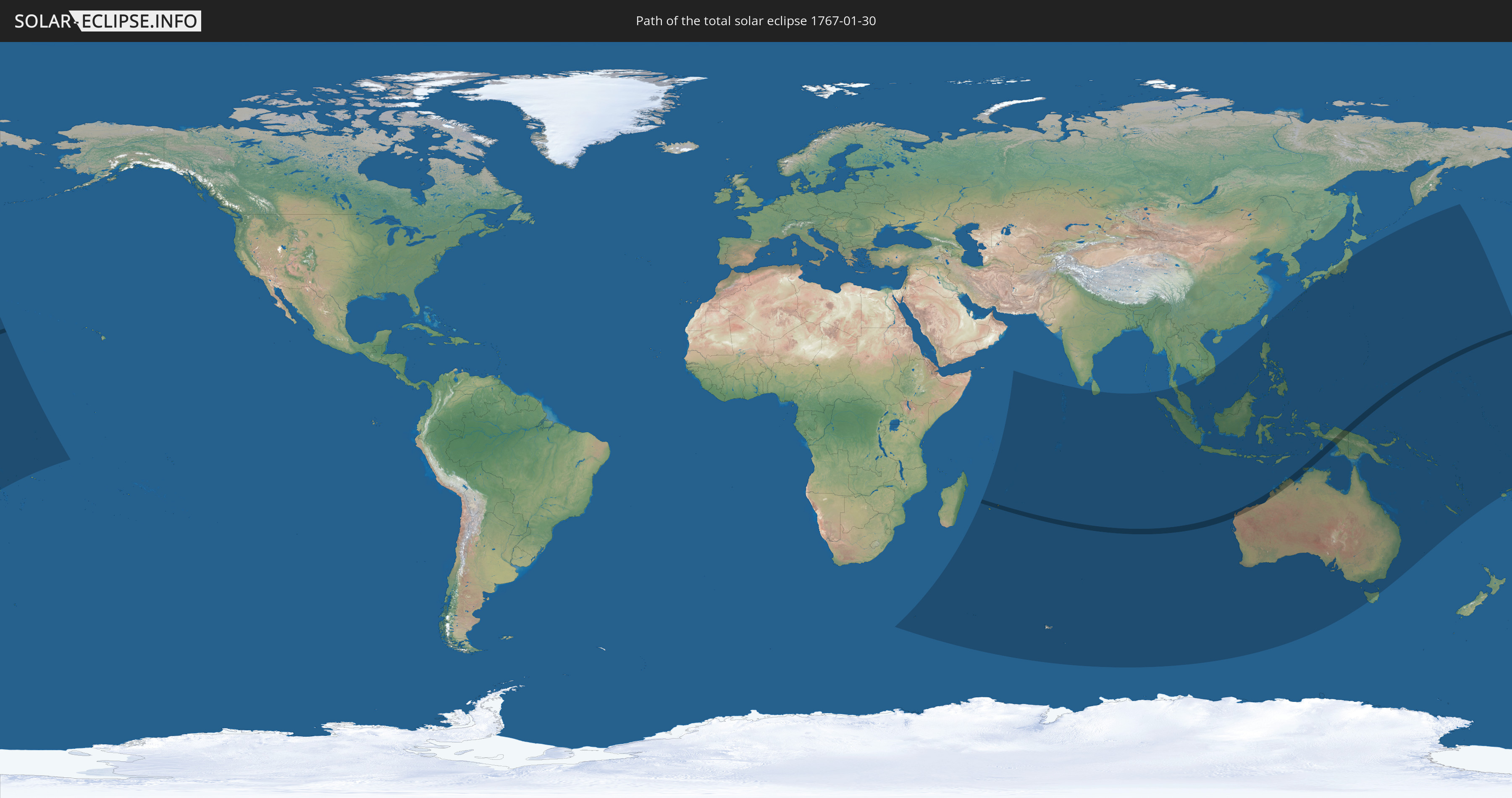
Die Sonnenfinsternis am 30.01.1767 kann man in 38 Ländern als partielle Sonnenfinsternis beobachten.
Der Finsternispfad verläuft durch 5 Länder. Nur in diesen Ländern ist sie als totale Sonnenfinsternis zu sehen.
In den folgenden Ländern ist die Sonnenfinsternis total zu sehen
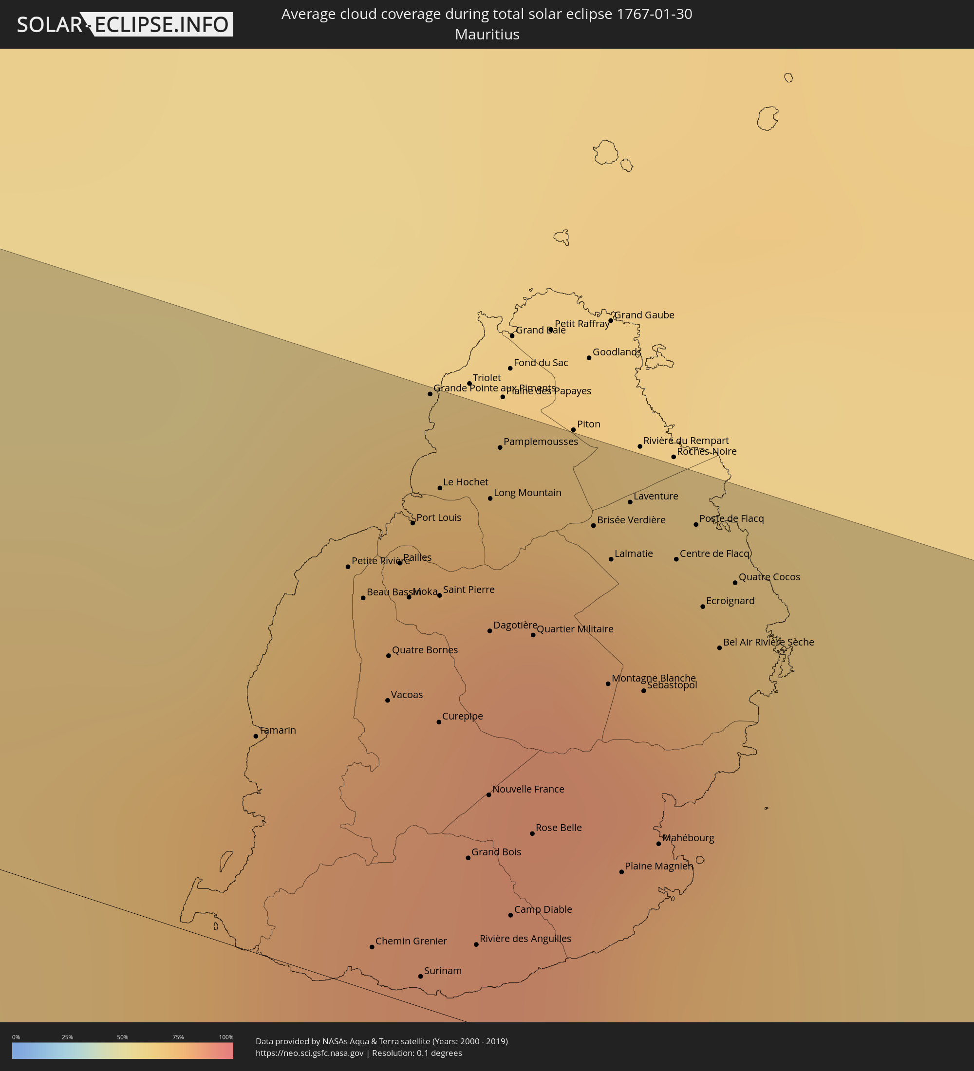
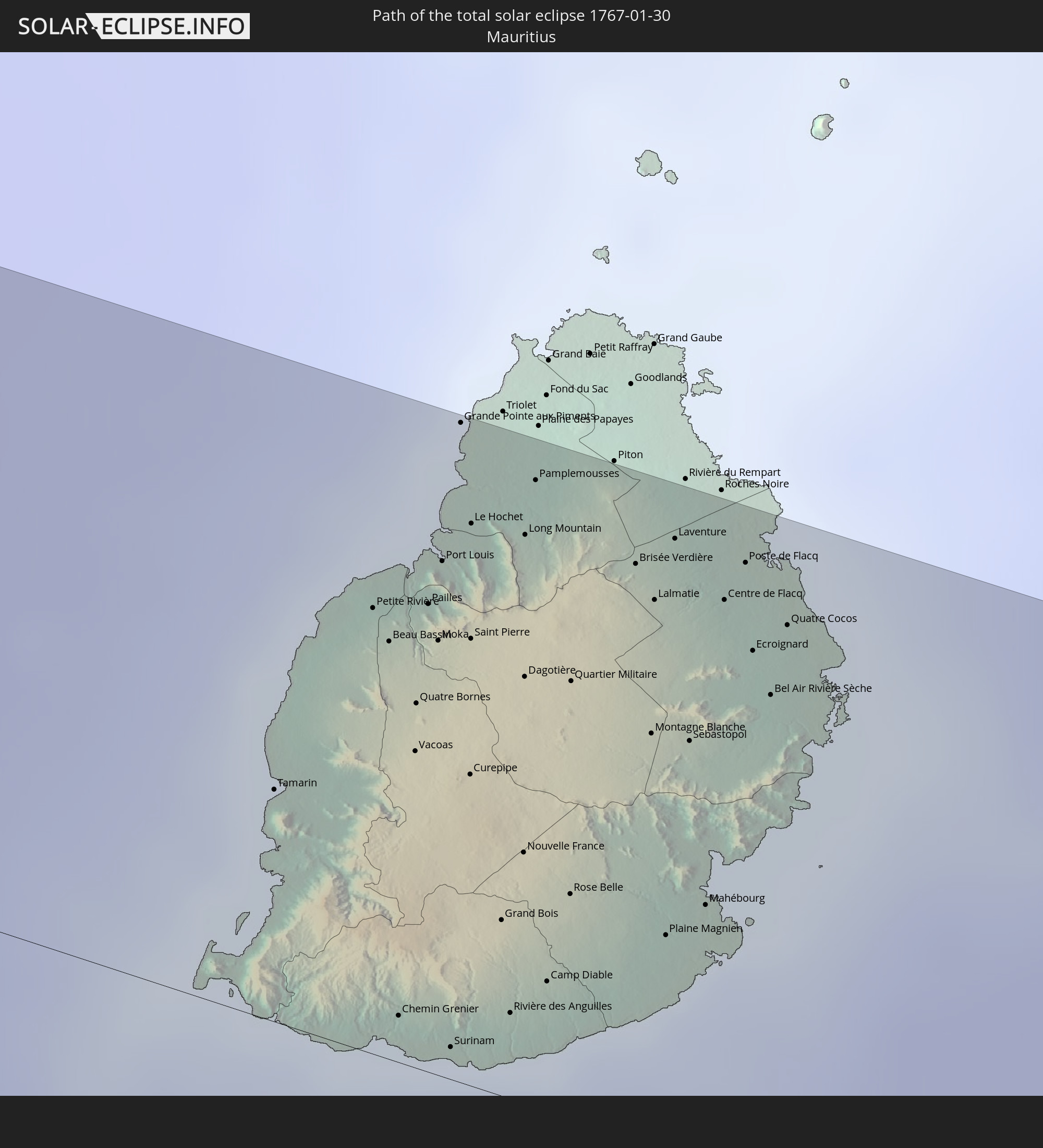 Mauritius
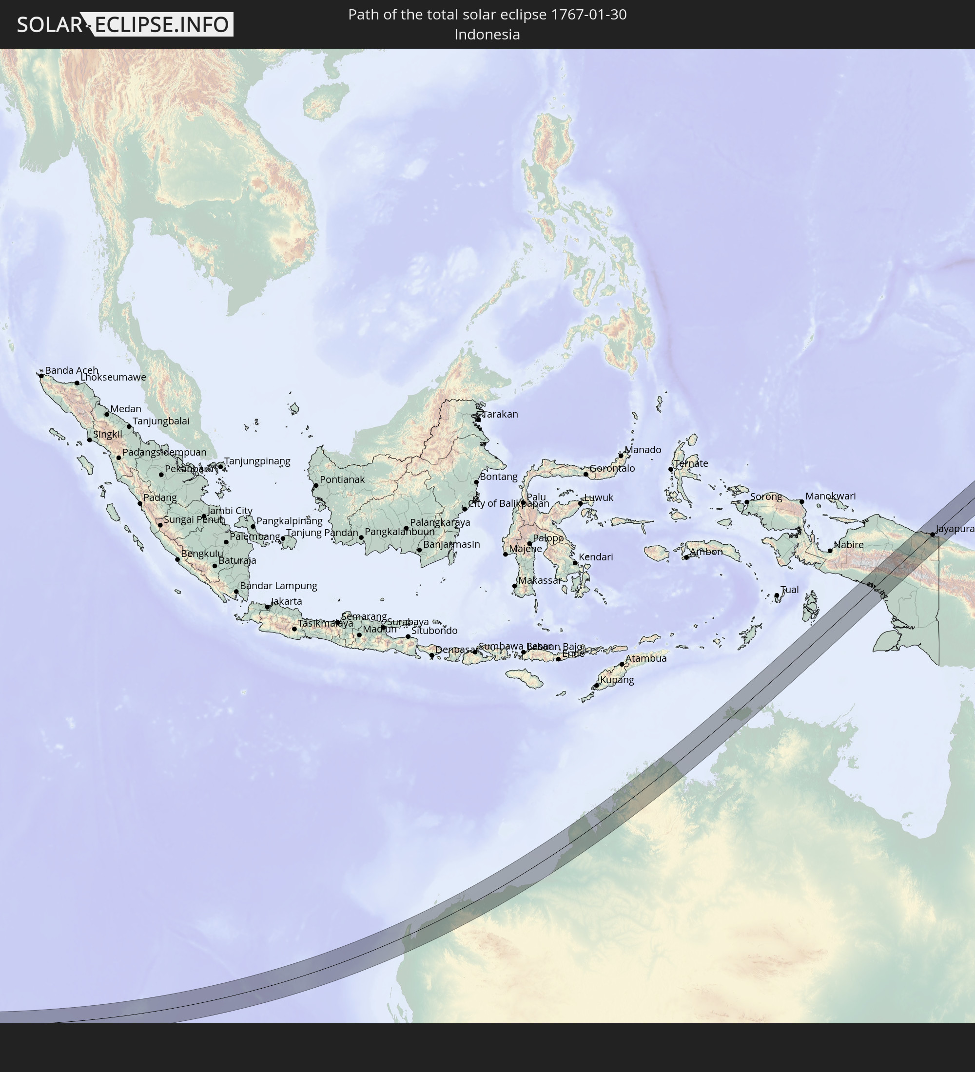 Indonesien
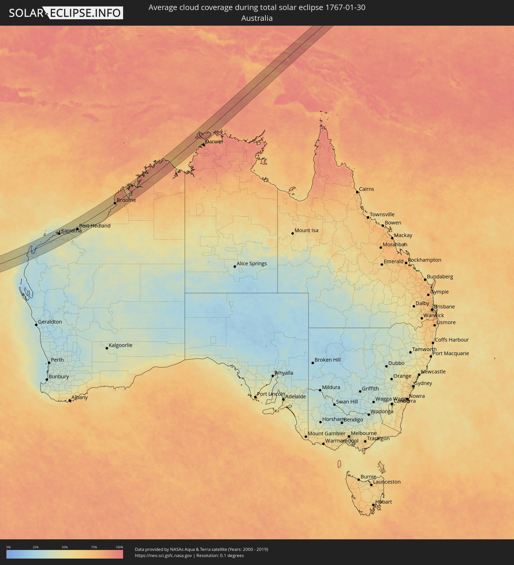
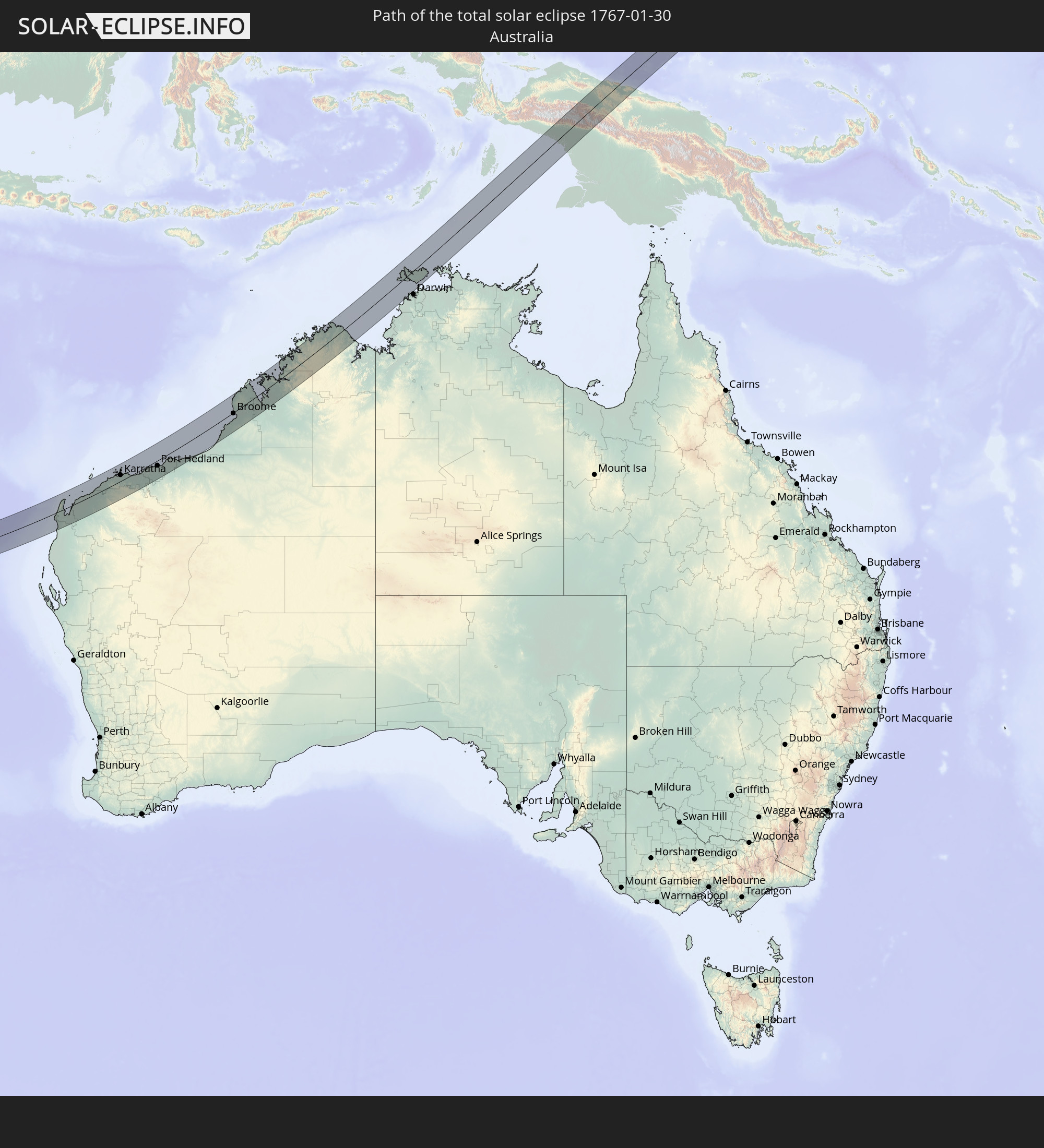 Australien
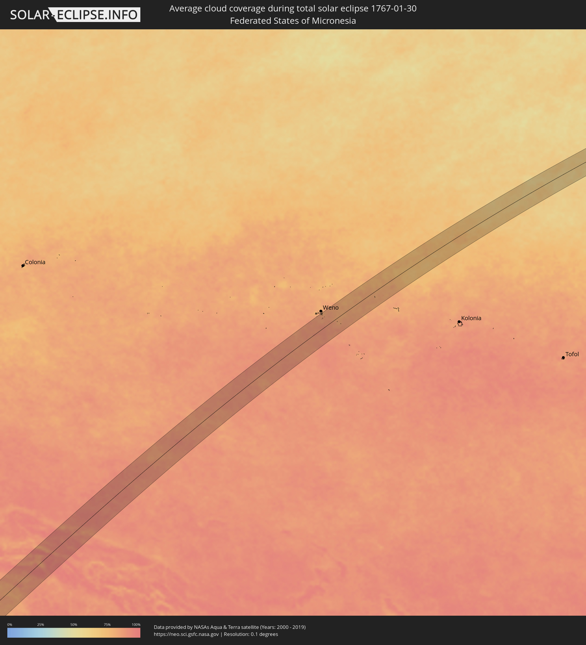
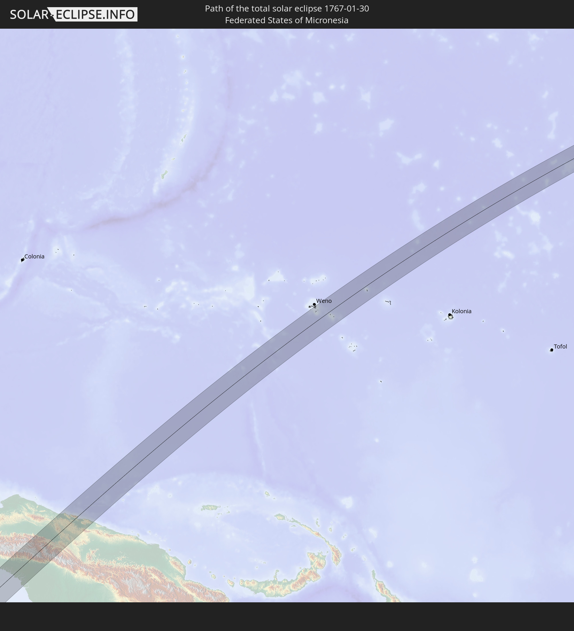 Föderierte Staaten von Mikronesien
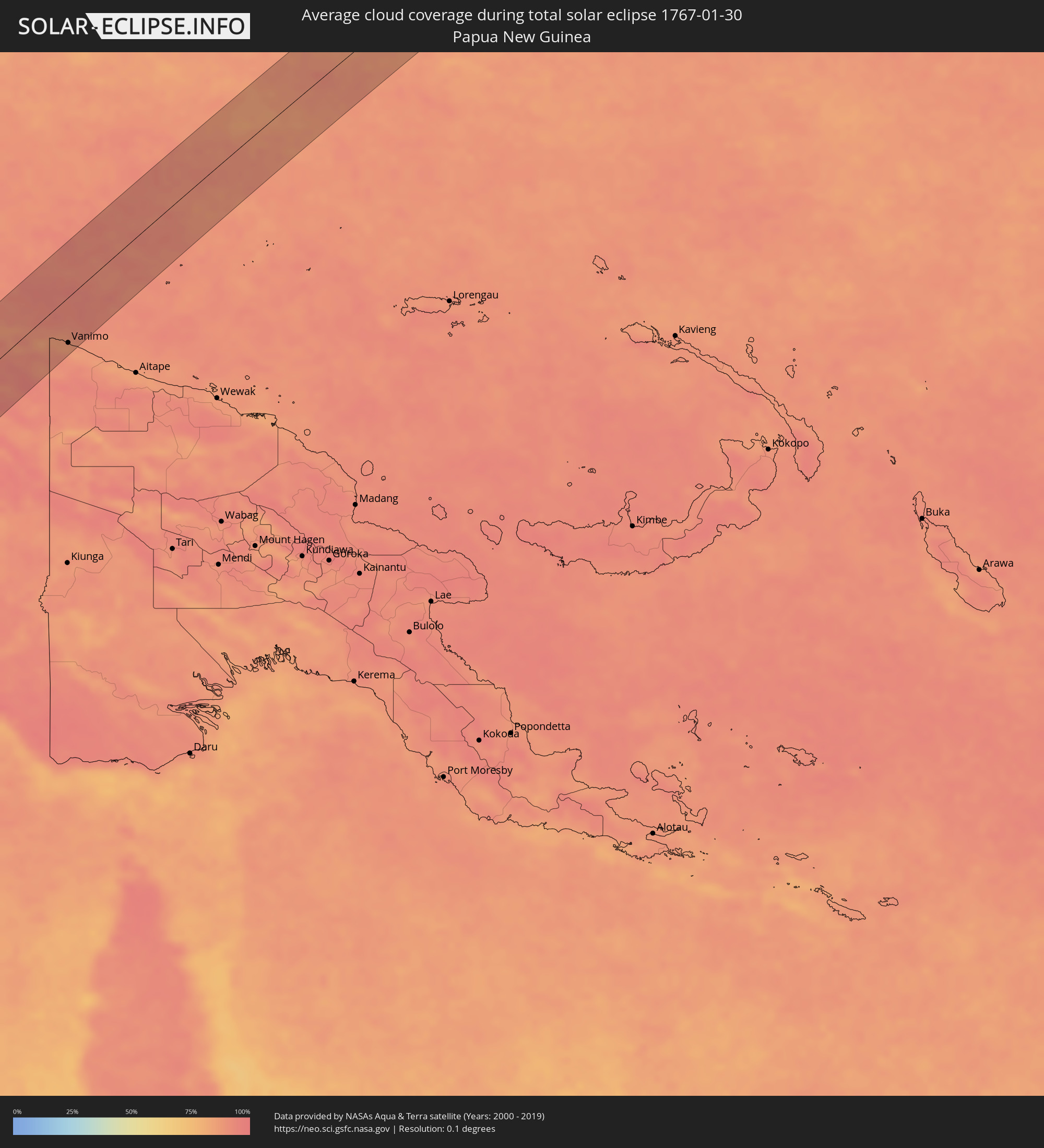
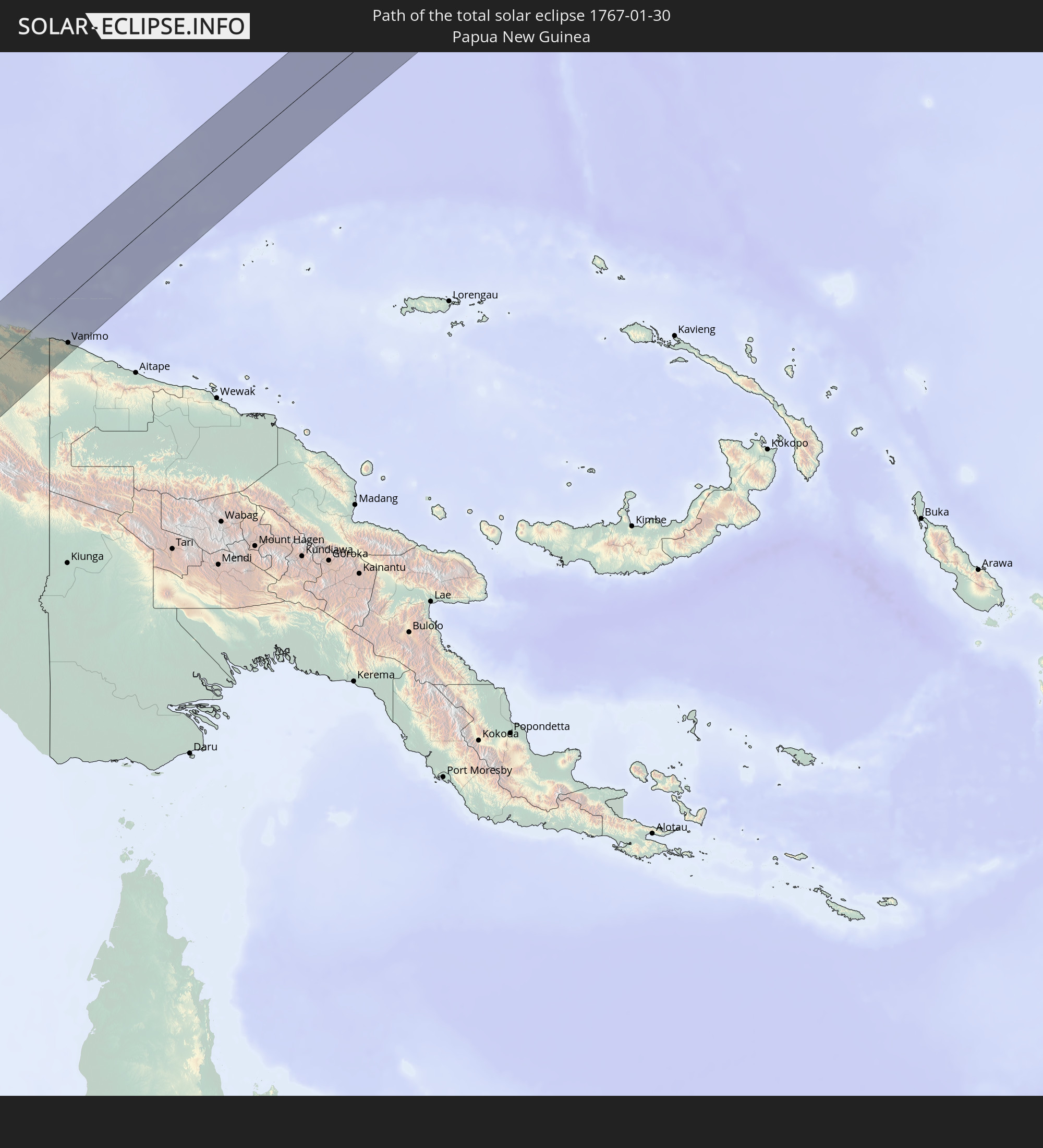 Papua-Neuguinea
In den folgenden Ländern ist die Sonnenfinsternis partiell zu sehen
 Fidschi
 United States Minor Outlying Islands
 Wallis und Futuna
 Kiribati
 Tokelau
 Amerikanisch-Samoa
 Französische Süd- und Antarktisgebiete
 Réunion
 Mauritius
 Britisches Territorium im Indischen Ozean
 Heard und McDonaldinseln
 Malediven
 Sri Lanka
 Indonesien
 Kokosinseln
 Thailand
 Malaysia
 Vietnam
 Kambodscha
 Singapur
 Weihnachtsinsel
 Australien
 Brunei
 Taiwan
 Philippinen
 Japan
Japan
 Osttimor
 Palau
Palau
 Föderierte Staaten von Mikronesien
 Papua-Neuguinea
 Guam
Guam
 Nördliche Marianen
 Salomonen
 Neukaledonien
 Marshallinseln
 Vanuatu
 Nauru
Nauru
 Tuvalu
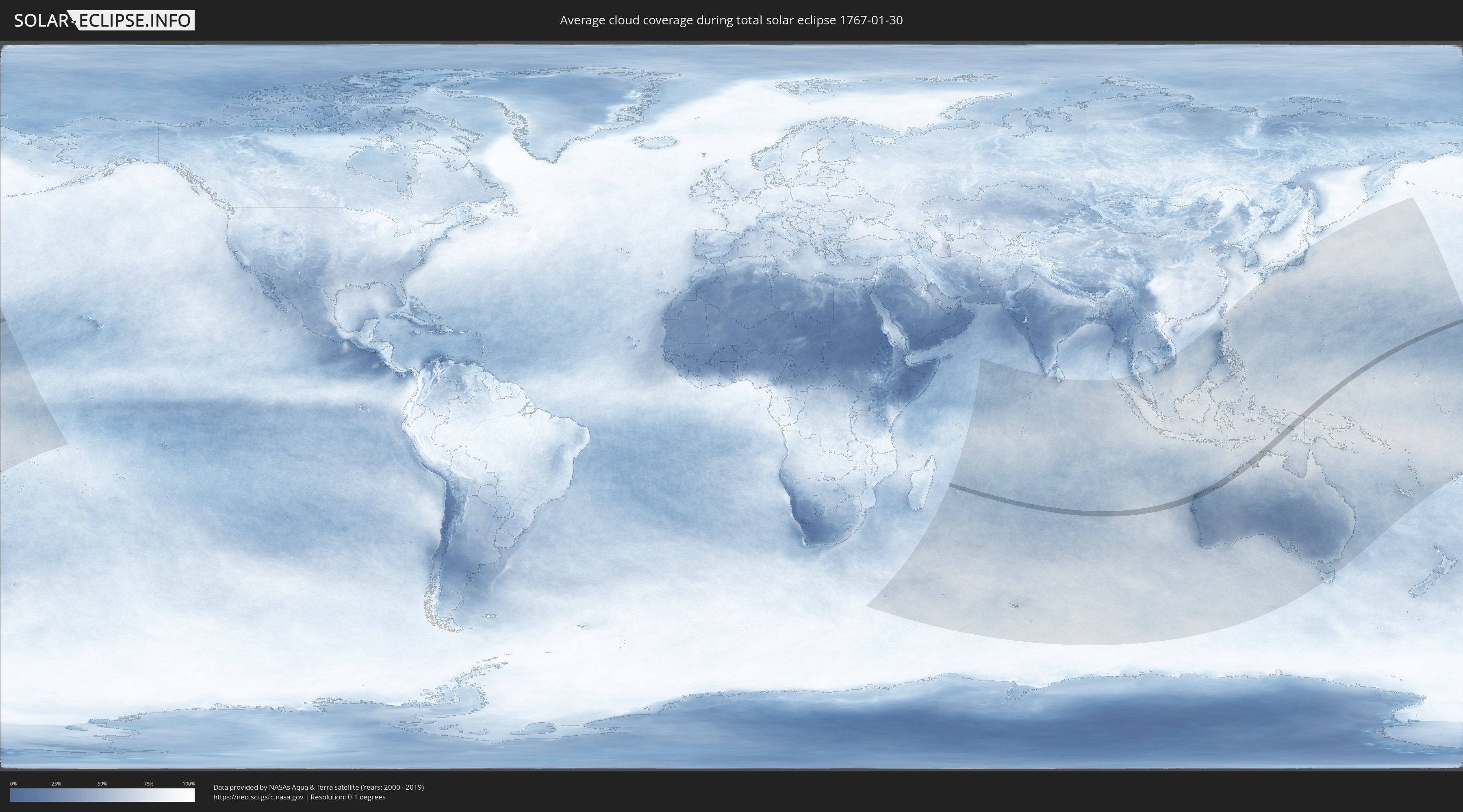
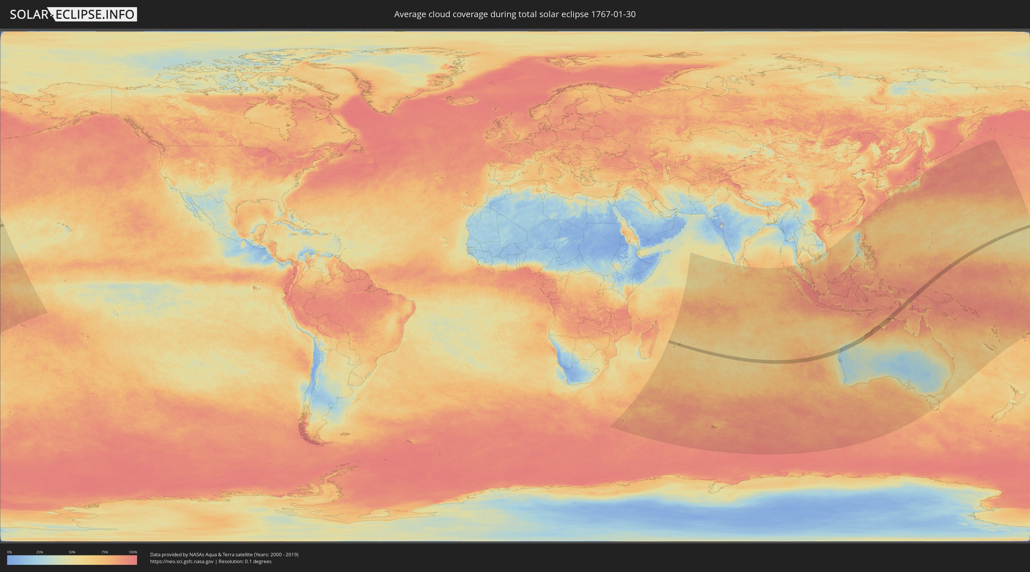
Wie wird das Wetter während der totalen Sonnenfinsternis am 30.01.1767?
Wo ist der beste Ort, um die totale Sonnenfinsternis vom 30.01.1767 zu beobachten?
Die folgenden Karten zeigen die durchschnittliche Bewölkung für den Tag, an dem die totale Sonnenfinsternis
stattfindet. Mit Hilfe der Karten lässt sich der Ort entlang des Finsternispfades eingrenzen,
der die besten Aussichen auf einen klaren wolkenfreien Himmel bietet.
Trotzdem muss man immer lokale Gegenenheiten beachten und sollte sich genau über das Wetter an seinem
gewählten Beobachtungsort informieren.
Die Daten stammen von den beiden NASA-Satelliten
AQUA und TERRA
und wurden über einen Zeitraum von 19 Jahren (2000 - 2019) gemittelt.
Detaillierte Länderkarten
 Mauritius
 Indonesien
 Australien
 Föderierte Staaten von Mikronesien
 Papua-Neuguinea
Orte im Finsternispfad
Die nachfolgene Tabelle zeigt Städte und Orte mit mehr als 5.000 Einwohnern, die sich im Finsternispfad befinden. Städte mit mehr als 100.000 Einwohnern sind dick gekennzeichnet. Mit einem Klick auf den Ort öffnet sich eine Detailkarte die die Lage des jeweiligen Ortes zusammen mit dem Verlauf der zentralen Finsternis präsentiert.
| Ort | Typ | Dauer der Verfinsterung | Ortszeit bei maximaler Verfinsterung | Entfernung zur Zentrallinie | Ø Bewölkung |
|
Tamarin, Black River
|
total | - | 06:03:42 UTC+03:50 | 18 km | 81% |
|
Petite Rivière, Black River
|
total | - | 06:03:40 UTC+03:50 | 34 km | 80% |
|
Beau Bassin, Plaines Wilhems
|
total | - | 06:03:41 UTC+03:50 | 32 km | 83% |
|
Chemin Grenier, Savanne
|
total | - | 06:03:44 UTC+03:50 | 4 km | 70% |
|
Vacoas, Plaines Wilhems
|
total | - | 06:03:42 UTC+03:50 | 24 km | 85% |
|
Quatre Bornes, Plaines Wilhems
|
total | - | 06:03:41 UTC+03:50 | 28 km | 85% |
|
Pailles, Moka
|
total | - | 06:03:41 UTC+03:50 | 35 km | 83% |
|
Moka, Moka
|
total | - | 06:03:41 UTC+03:50 | 33 km | 83% |
|
Port Louis, Port Louis
|
total | - | 06:03:40 UTC+03:50 | 39 km | 83% |
|
Surinam, Savanne
|
total | - | 06:03:45 UTC+03:50 | 2 km | 70% |
|
Grande Pointe aux Piments, Pamplemousses
|
total | - | 06:03:39 UTC+03:50 | 50 km | 80% |
|
Souillac, Savanne
|
total | - | 06:03:45 UTC+03:50 | 2 km | 70% |
|
Curepipe, Plaines Wilhems
|
total | - | 06:03:42 UTC+03:50 | 24 km | 85% |
|
Saint Pierre, Moka
|
total | - | 06:03:41 UTC+03:50 | 34 km | 83% |
|
Le Hochet, Pamplemousses
|
total | - | 06:03:40 UTC+03:50 | 43 km | 80% |
|
Terre Rouge, Pamplemousses
|
total | - | 06:03:40 UTC+03:50 | 44 km | 80% |
|
Grand Bois, Savanne
|
total | - | 06:03:44 UTC+03:50 | 13 km | 83% |
|
Rivière des Anguilles, Savanne
|
total | - | 06:03:45 UTC+03:50 | 6 km | 69% |
|
Morcellemont Saint André, Pamplemousses
|
total | - | 06:03:39 UTC+03:50 | 50 km | 84% |
|
Nouvelle France, Grand Port
|
total | - | 06:03:43 UTC+03:50 | 19 km | 79% |
|
Dagotière, Moka
|
total | - | 06:03:41 UTC+03:50 | 32 km | 87% |
|
Long Mountain, Pamplemousses
|
total | - | 06:03:40 UTC+03:50 | 43 km | 84% |
|
Pamplemousses, Pamplemousses
|
total | - | 06:03:40 UTC+03:50 | 47 km | 84% |
|
Camp Diable, Savanne
|
total | - | 06:03:45 UTC+03:50 | 10 km | 69% |
|
Rose Belle, Grand Port
|
total | - | 06:03:44 UTC+03:50 | 17 km | 79% |
|
Quartier Militaire, Moka
|
total | - | 06:03:42 UTC+03:50 | 33 km | 87% |
|
New Grove, Grand Port
|
total | - | 06:03:44 UTC+03:50 | 17 km | 79% |
|
Brisée Verdière, Flacq
|
total | - | 06:03:41 UTC+03:50 | 44 km | 87% |
|
Bon Accueil, Flacq
|
total | - | 06:03:41 UTC+03:50 | 43 km | 83% |
|
Montagne Blanche
|
total | - | 06:03:42 UTC+03:50 | 31 km | 77% |
|
Lalmatie, Flacq
|
total | - | 06:03:41 UTC+03:50 | 41 km | 83% |
|
Plaine Magnien, Grand Port
|
total | - | 06:03:44 UTC+03:50 | 16 km | 70% |
|
Laventure, Flacq
|
total | - | 06:03:41 UTC+03:50 | 46 km | 75% |
|
Sebastopol, Flacq
|
total | - | 06:03:43 UTC+03:50 | 32 km | 77% |
|
Beau Vallon, Grand Port
|
total | - | 06:03:44 UTC+03:50 | 18 km | 70% |
|
Mahébourg, Grand Port
|
total | - | 06:03:44 UTC+03:50 | 19 km | 70% |
|
Centre de Flacq, Flacq
|
total | - | 06:03:41 UTC+03:50 | 43 km | 83% |
|
Poste de Flacq, Flacq
|
total | - | 06:03:41 UTC+03:50 | 46 km | 83% |
|
Ecroignard, Flacq
|
total | - | 06:03:42 UTC+03:50 | 40 km | 83% |
|
Bel Air Rivière Sèche, Flacq
|
total | - | 06:03:42 UTC+03:50 | 37 km | 77% |
|
Quatre Cocos, Flacq
|
total | - | 06:03:42 UTC+03:50 | 43 km | 68% |
|
Karratha, Western Australia
|
total | - | 11:34:21 UTC+08:00 | 26 km | 40% |
|
Port Hedland, Western Australia
|
total | - | 11:39:03 UTC+08:00 | 22 km | 45% |
|
Broome, Western Australia
|
total | - | 11:51:05 UTC+08:00 | 4 km | 63% |
|
Abepura, Papua
|
total | - | 14:16:36 UTC+09:22 | 2 km | 88% |
|
Jayapura, Papua
|
total | - | 14:16:49 UTC+09:22 | 4 km | 91% |
|
Vanimo, Sandaun
|
total | - | 14:54:37 UTC+10:00 | 55 km | 89% |
|
Vanimo, Sandaun
|
total | - | 14:54:39 UTC+10:00 | 59 km | 89% |