Totale Sonnenfinsternis vom 27.07.1813
| Wochentag: | Dienstag |
| Maximale Dauer der Verfinsterung: | 03m27s |
| Maximale Breite des Finsternispfades: | 144 km |
| Saroszyklus: | 123 |
| Bedeckungsgrad: | 100% |
| Magnitude: | 1.0341 |
| Gamma: | -0.6006 |
Wo kann man die Sonnenfinsternis vom 27.07.1813 sehen?
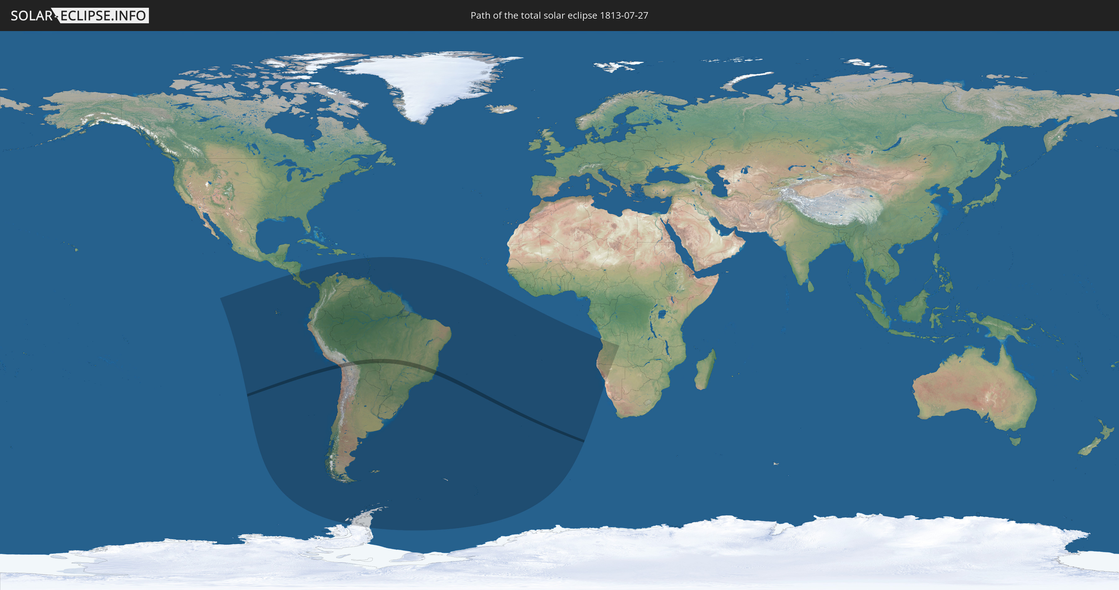
Die Sonnenfinsternis am 27.07.1813 kann man in 32 Ländern als partielle Sonnenfinsternis beobachten.
Der Finsternispfad verläuft durch 4 Länder. Nur in diesen Ländern ist sie als totale Sonnenfinsternis zu sehen.
In den folgenden Ländern ist die Sonnenfinsternis total zu sehen
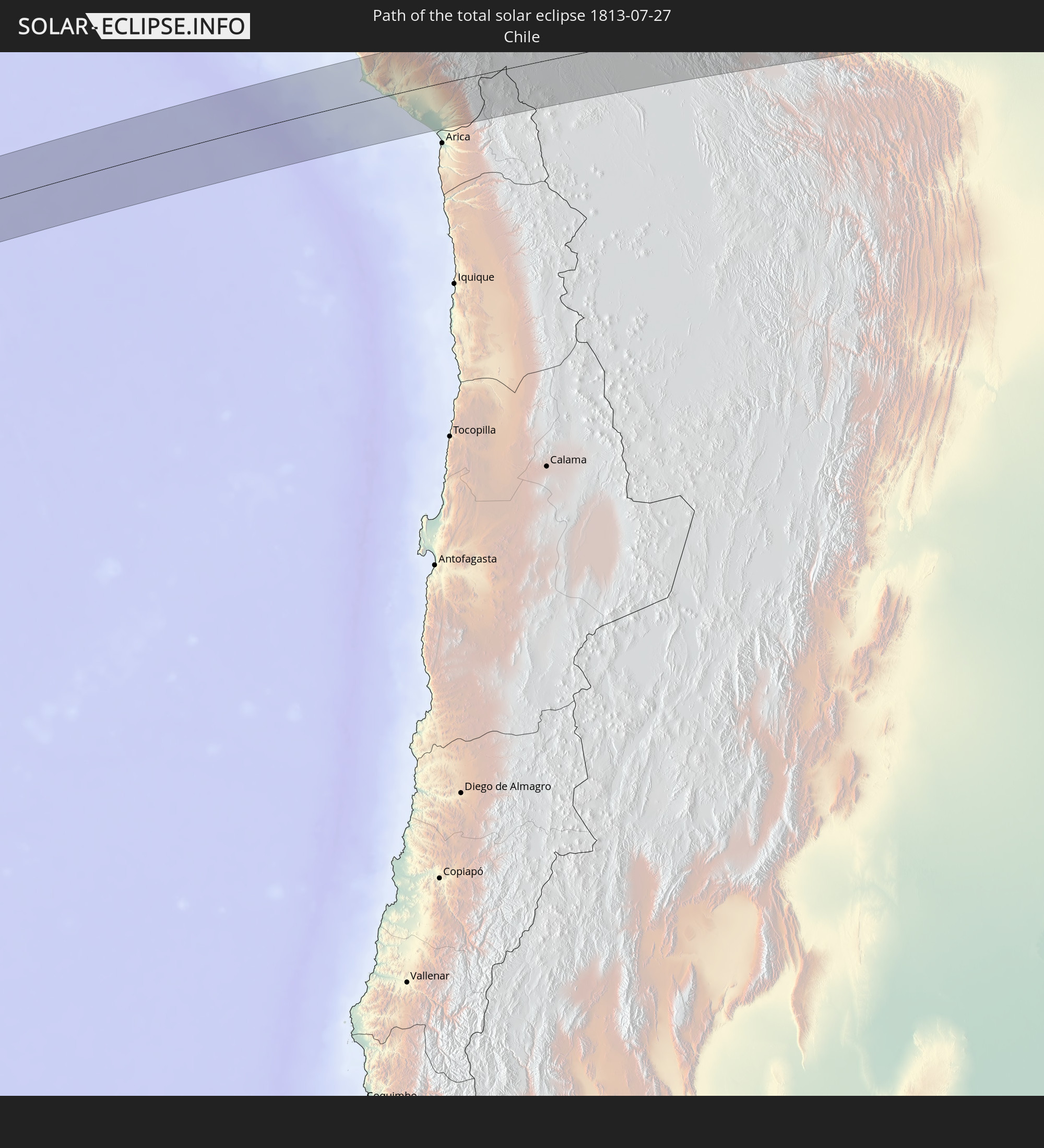 Chile
Chile
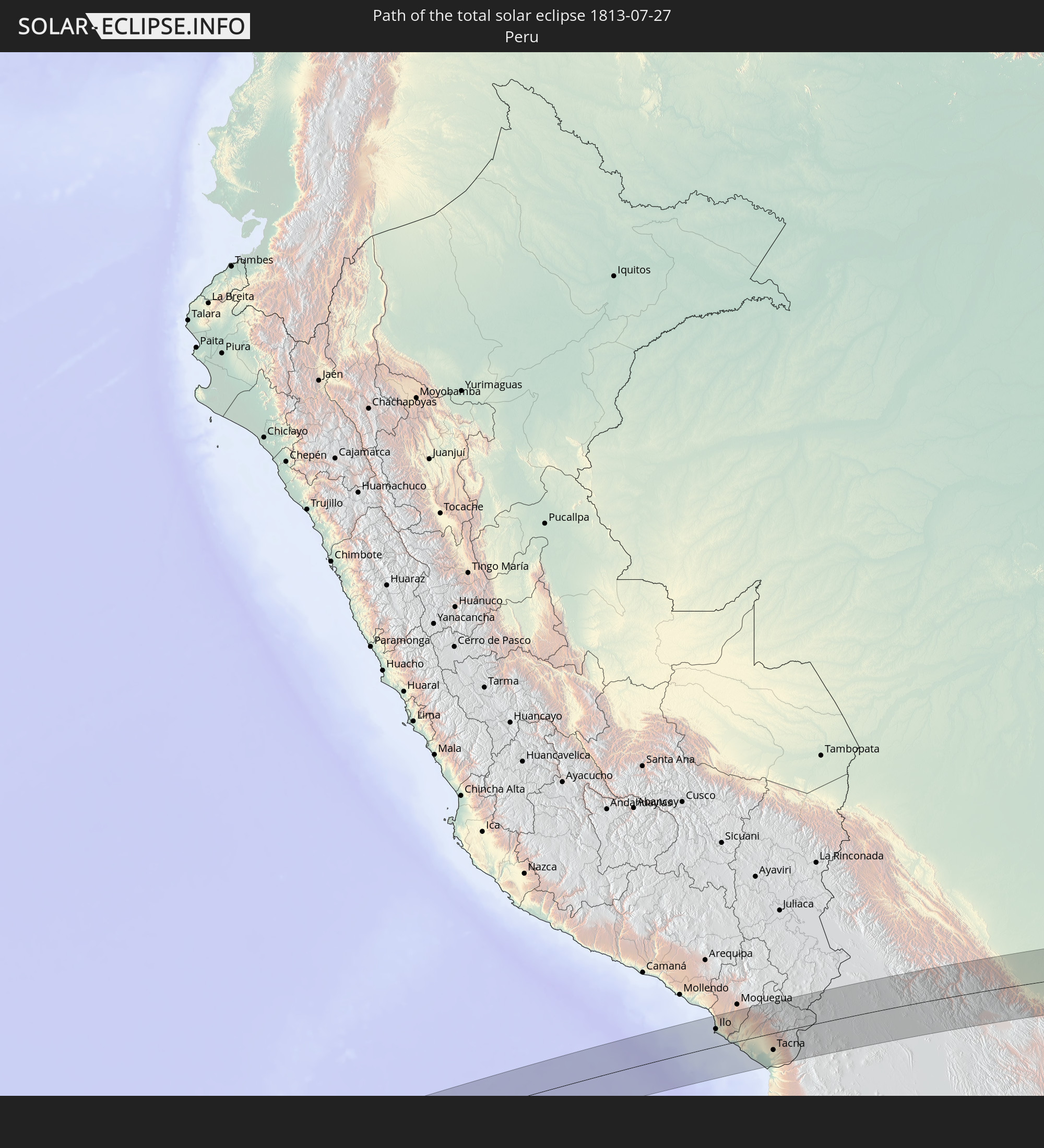 Peru
Peru
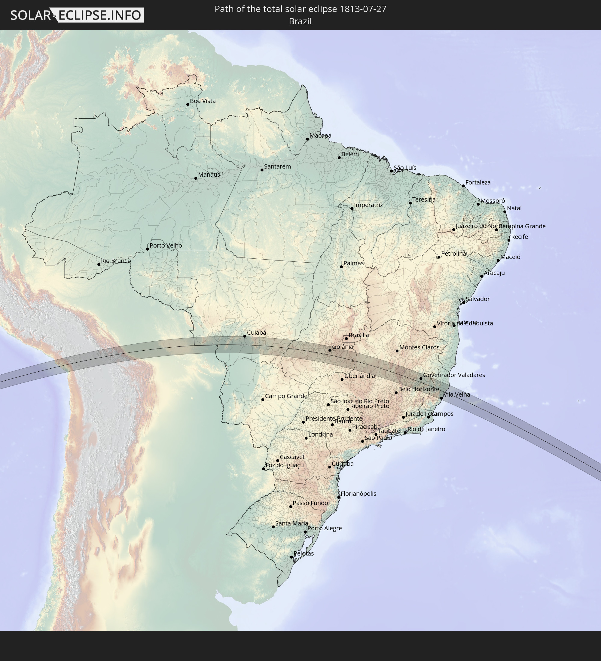 Brasilien
 Bolivien
In den folgenden Ländern ist die Sonnenfinsternis partiell zu sehen
 Antarktika
 Chile
Chile
 Ecuador
 Nicaragua
 Costa Rica
 Panama
 Kolumbien
 Peru
Peru
 Brasilien
 Argentinien
 Venezuela
 Aruba
Aruba
 Bolivien
 Paraguay
 Montserrat
 Trinidad und Tobago
 Guadeloupe
 Grenada
 Dominica
 St. Vincent und die Grenadinen
 Falklandinseln
 Guyana
 Martinique
 St. Lucia
 Barbados
 Uruguay
 Suriname
 Französisch-Guayana
 Südgeorgien und die Südlichen Sandwichinseln
 St. Helena
 Angola
 Namibia
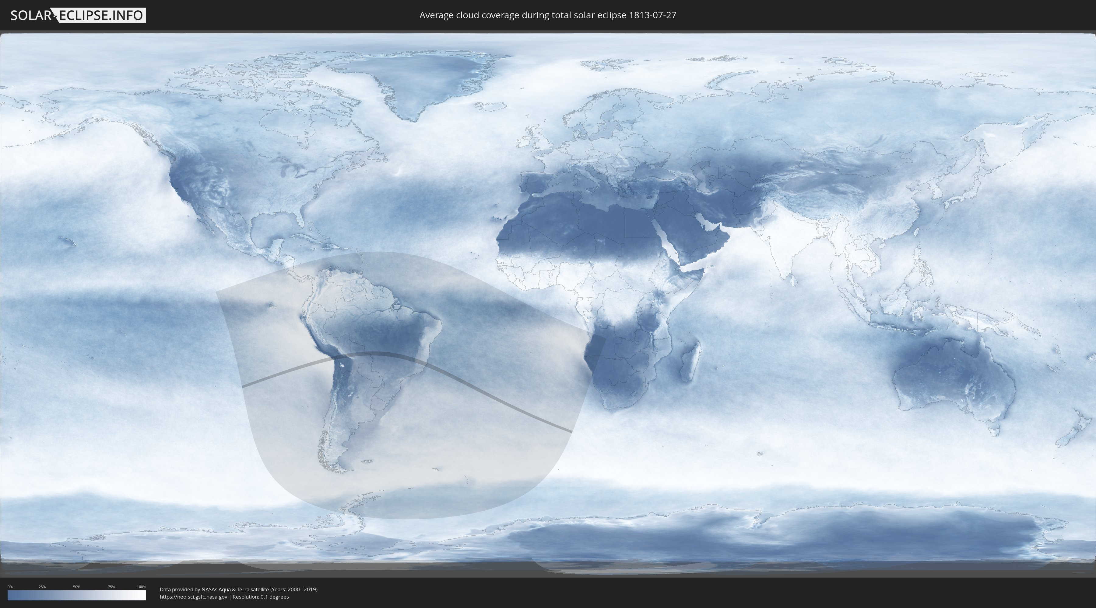
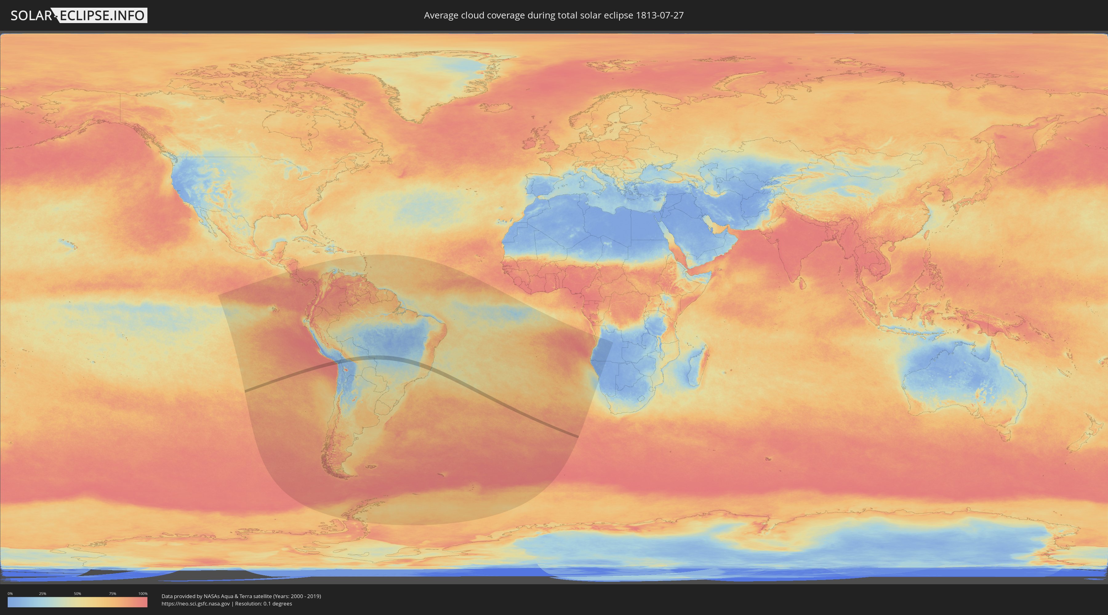
Wie wird das Wetter während der totalen Sonnenfinsternis am 27.07.1813?
Wo ist der beste Ort, um die totale Sonnenfinsternis vom 27.07.1813 zu beobachten?
Die folgenden Karten zeigen die durchschnittliche Bewölkung für den Tag, an dem die totale Sonnenfinsternis
stattfindet. Mit Hilfe der Karten lässt sich der Ort entlang des Finsternispfades eingrenzen,
der die besten Aussichen auf einen klaren wolkenfreien Himmel bietet.
Trotzdem muss man immer lokale Gegenenheiten beachten und sollte sich genau über das Wetter an seinem
gewählten Beobachtungsort informieren.
Die Daten stammen von den beiden NASA-Satelliten
AQUA und TERRA
und wurden über einen Zeitraum von 19 Jahren (2000 - 2019) gemittelt.
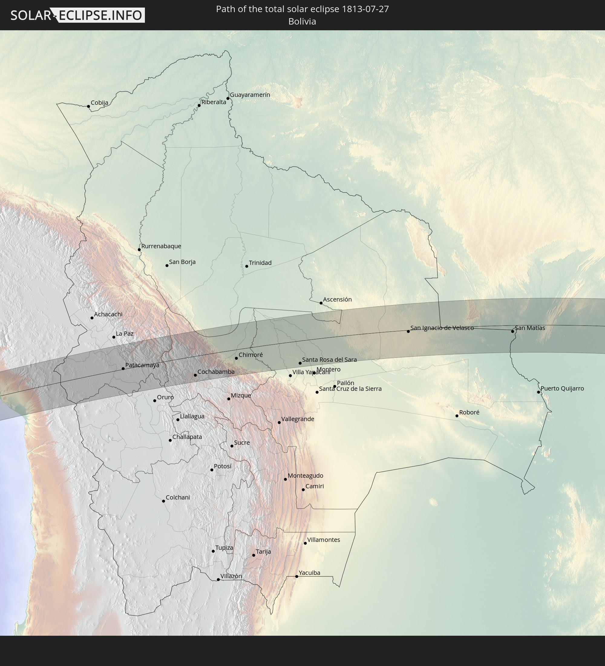
Detaillierte Länderkarten
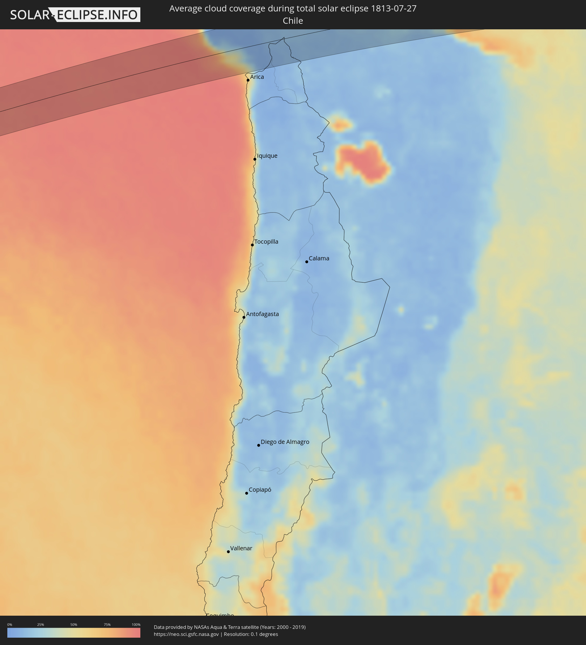 Chile
Chile
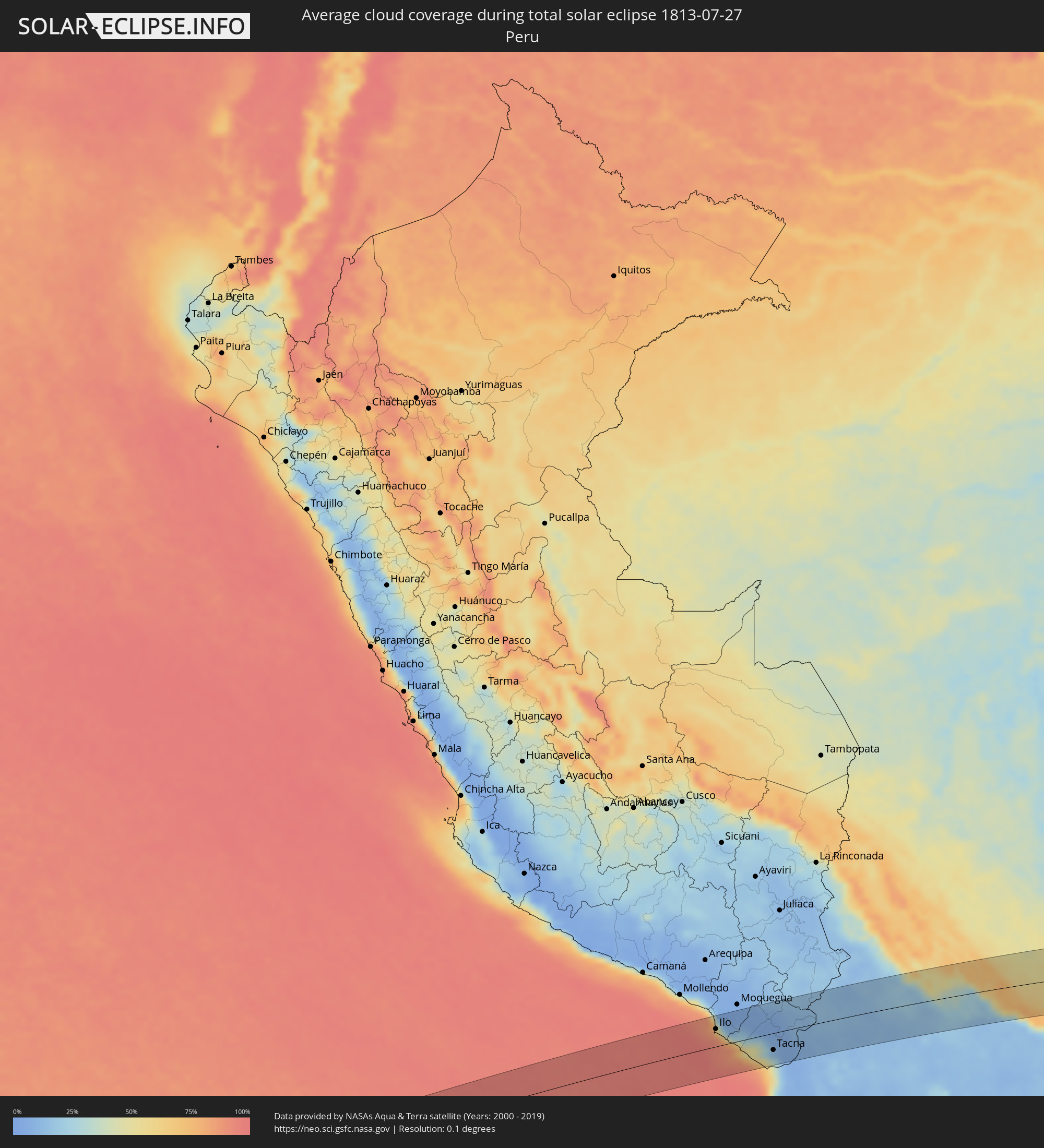 Peru
Peru
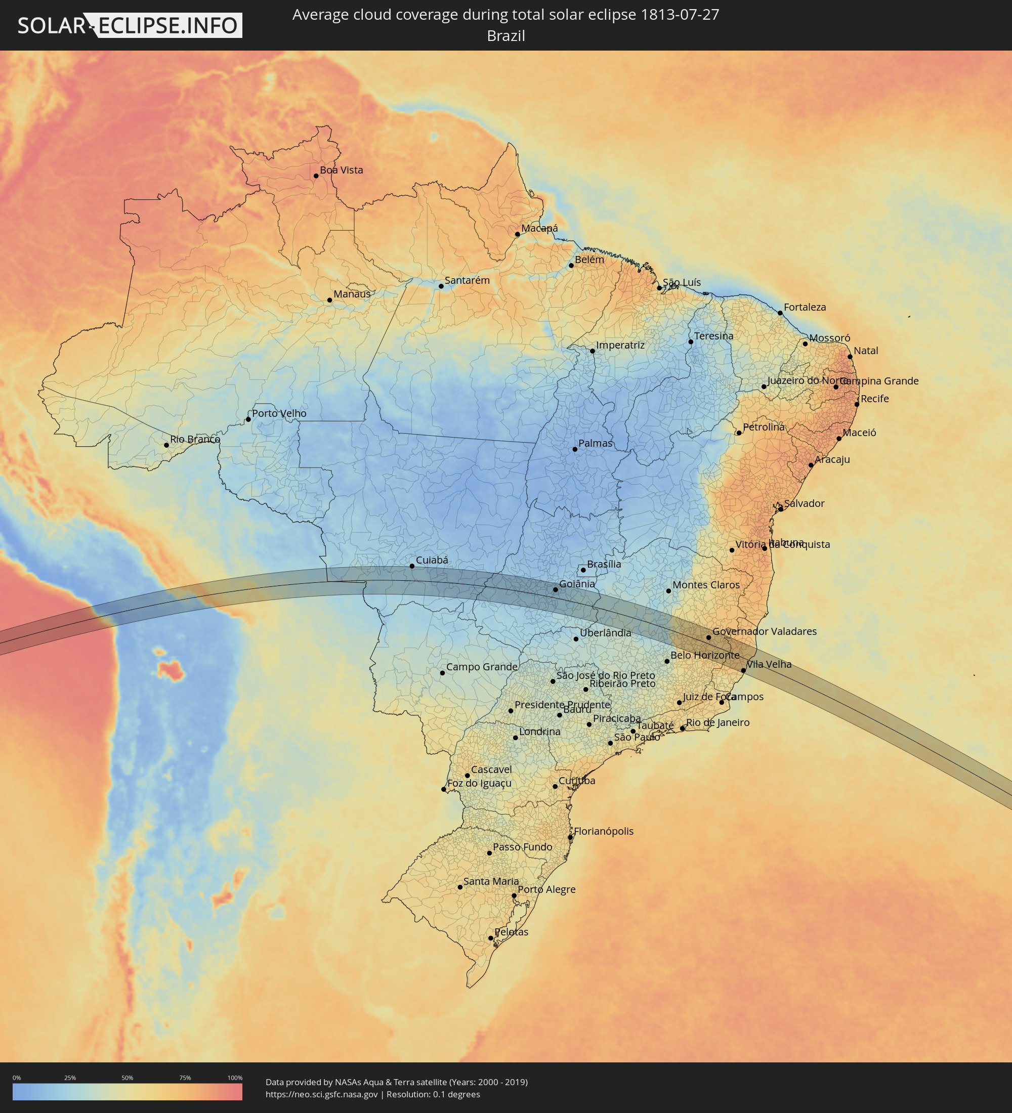 Brasilien
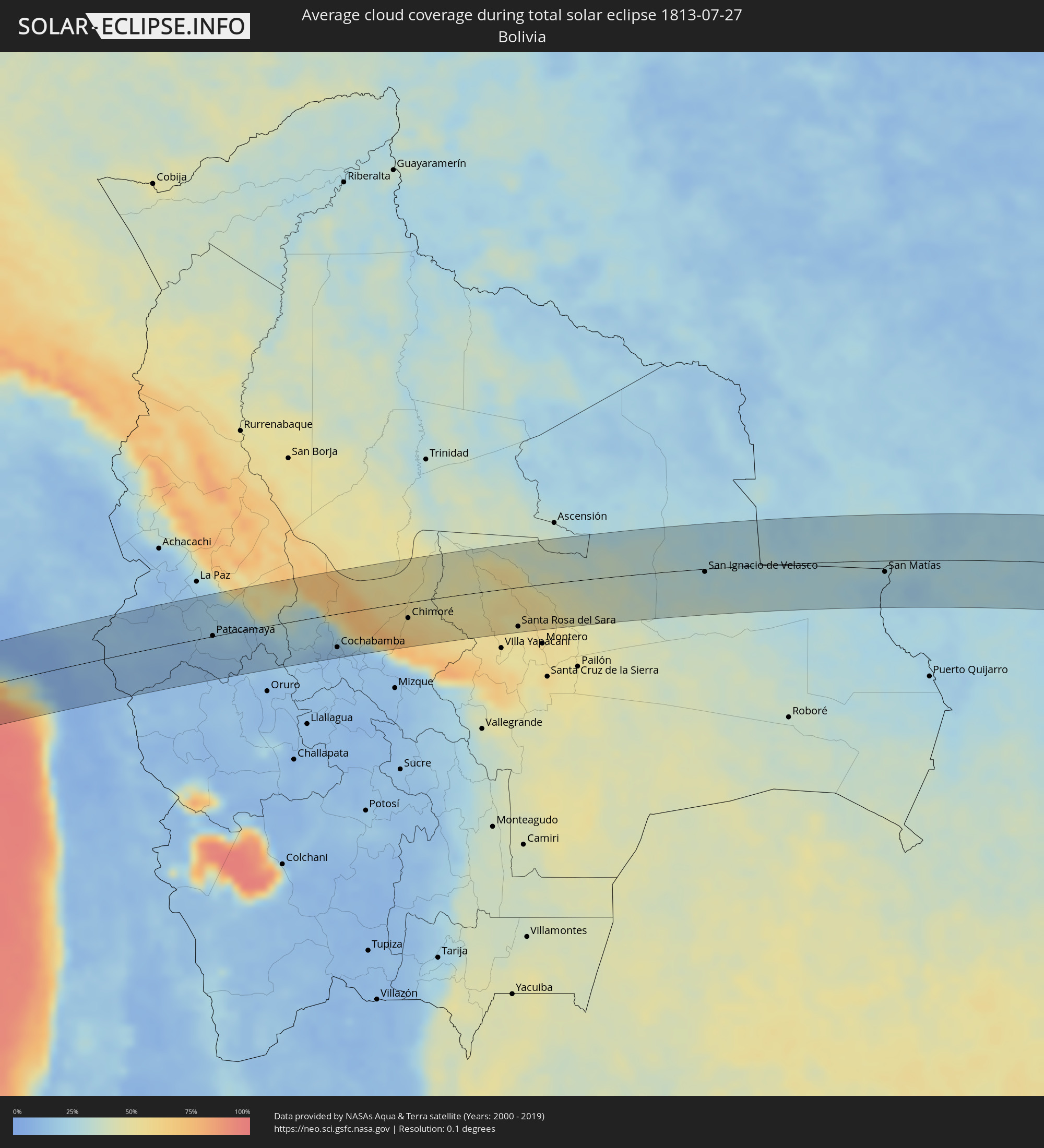 Bolivien
Orte im Finsternispfad
Die nachfolgene Tabelle zeigt Städte und Orte mit mehr als 5.000 Einwohnern, die sich im Finsternispfad befinden. Städte mit mehr als 100.000 Einwohnern sind dick gekennzeichnet. Mit einem Klick auf den Ort öffnet sich eine Detailkarte die die Lage des jeweiligen Ortes zusammen mit dem Verlauf der zentralen Finsternis präsentiert.
| Ort | Typ | Dauer der Verfinsterung | Ortszeit bei maximaler Verfinsterung | Entfernung zur Zentrallinie | Ø Bewölkung |
|
Ilo, Moquegua
|
total | - | 08:42:56 UTC-05:08 | 34 km | 64% |
|
Pacocha, Moquegua
|
total | - | 08:42:54 UTC-05:08 | 40 km | 64% |
|
Ilabaya, Tacna
|
total | - | 08:44:22 UTC-05:08 | 38 km | 6% |
|
Tacna, Tacna
|
total | - | 08:45:18 UTC-05:08 | 33 km | 34% |
|
Patacamaya, La Paz
|
total | - | 09:25:33 UTC-04:32 | 1 km | 17% |
|
Cochabamba, Cochabamba
|
total | - | 09:29:34 UTC-04:32 | 50 km | 13% |
|
Chimoré, Cochabamba
|
total | - | 09:31:37 UTC-04:32 | 23 km | 60% |
|
Santa Rosa del Sara, Santa Cruz
|
total | - | 09:35:27 UTC-04:32 | 59 km | 49% |
|
Mineros, Santa Cruz
|
total | - | 09:36:22 UTC-04:32 | 64 km | 54% |
|
San Ignacio de Velasco, Santa Cruz
|
total | - | 09:41:42 UTC-04:32 | 4 km | 30% |
|
Concepción, Santa Cruz
|
total | - | 09:41:53 UTC-04:32 | 12 km | 28% |
|
San Matías, Santa Cruz
|
total | - | 09:48:40 UTC-04:32 | 17 km | 24% |
|
Poconé, Mato Grosso
|
total | - | 10:47:49 UTC-03:38 | 4 km | 23% |
|
Cuiabá, Mato Grosso
|
total | - | 10:48:53 UTC-03:38 | 71 km | 25% |
|
Lucas, Mato Grosso
|
total | - | 10:49:53 UTC-03:38 | 11 km | 25% |
|
Jaciara, Mato Grosso
|
total | - | 10:52:29 UTC-03:38 | 36 km | 17% |
|
Rondonópolis, Mato Grosso
|
total | - | 10:53:51 UTC-03:38 | 18 km | 17% |
|
Poxoréo, Mato Grosso
|
total | - | 10:54:08 UTC-03:38 | 54 km | 15% |
|
Guiratinga, Mato Grosso
|
total | - | 10:56:24 UTC-03:38 | 3 km | 17% |
|
Barra do Garças, Mato Grosso
|
total | - | 11:00:40 UTC-03:38 | 72 km | 16% |
|
Aragarças, Goiás
|
total | - | 11:00:41 UTC-03:38 | 71 km | 16% |
|
Piranhas, Goiás
|
total | - | 11:34:23 UTC-03:06 | 19 km | 18% |
|
Caiapônia, Goiás
|
total | - | 11:34:48 UTC-03:06 | 40 km | 16% |
|
Iporá, Goiás
|
total | - | 11:36:35 UTC-03:06 | 28 km | 17% |
|
Paraúna, Goiás
|
total | - | 11:39:01 UTC-03:06 | 15 km | 19% |
|
São Luís de Montes Belos, Goiás
|
total | - | 11:38:57 UTC-03:06 | 32 km | 19% |
|
Anicuns, Goiás
|
total | - | 11:40:11 UTC-03:06 | 47 km | 19% |
|
Edéia, Goiás
|
total | - | 11:40:54 UTC-03:06 | 48 km | 22% |
|
Palmeiras de Goiás, Goiás
|
total | - | 11:40:33 UTC-03:06 | 10 km | 20% |
|
Guapó, Goiás
|
total | - | 11:41:48 UTC-03:06 | 16 km | 19% |
|
Inhumas, Goiás
|
total | - | 11:41:34 UTC-03:06 | 68 km | 18% |
|
Trindade, Goiás
|
total | - | 11:41:48 UTC-03:06 | 36 km | 18% |
|
Pontalina, Goiás
|
total | - | 11:42:33 UTC-03:06 | 58 km | 23% |
|
Goianira, Goiás
|
total | - | 11:41:53 UTC-03:06 | 54 km | 18% |
|
Goiânia, Goiás
|
total | - | 11:42:33 UTC-03:06 | 38 km | 18% |
|
Aparecida de Goiânia, Goiás
|
total | - | 11:42:41 UTC-03:06 | 23 km | 21% |
|
Nerópolis, Goiás
|
total | - | 11:42:28 UTC-03:06 | 69 km | 21% |
|
Senador Canedo, Goiás
|
total | - | 11:43:04 UTC-03:06 | 38 km | 21% |
|
Goianápolis, Goiás
|
total | - | 11:43:09 UTC-03:06 | 62 km | 20% |
|
Piracanjuba, Goiás
|
total | - | 11:43:44 UTC-03:06 | 25 km | 23% |
|
Bela Vista de Goiás, Goiás
|
total | - | 11:43:42 UTC-03:06 | 13 km | 24% |
|
Caldas Novas, Goiás
|
total | - | 11:45:15 UTC-03:06 | 64 km | 25% |
|
Silvânia, Goiás
|
total | - | 11:44:33 UTC-03:06 | 55 km | 22% |
|
Pires do Rio, Goiás
|
total | - | 11:46:02 UTC-03:06 | 7 km | 26% |
|
Ipameri, Goiás
|
total | - | 11:46:42 UTC-03:06 | 50 km | 26% |
|
Cristalina, Goiás
|
total | - | 11:47:44 UTC-03:06 | 67 km | 29% |
|
Vazante, Minas Gerais
|
total | - | 11:50:46 UTC-03:06 | 45 km | 31% |
|
Paracatu, Minas Gerais
|
total | - | 11:50:21 UTC-03:06 | 38 km | 30% |
|
João Pinheiro, Minas Gerais
|
total | - | 11:52:53 UTC-03:06 | 2 km | 33% |
|
Várzea da Palma, Minas Gerais
|
total | - | 11:57:13 UTC-03:06 | 62 km | 29% |
|
Corinto, Minas Gerais
|
total | - | 11:58:35 UTC-03:06 | 12 km | 31% |
|
Curvelo, Minas Gerais
|
total | - | 11:58:54 UTC-03:06 | 51 km | 33% |
|
Diamantina, Minas Gerais
|
total | - | 12:01:05 UTC-03:06 | 31 km | 47% |
|
Conceição do Mato Dentro, Minas Gerais
|
total | - | 12:02:07 UTC-03:06 | 46 km | 60% |
|
Serro, Minas Gerais
|
total | - | 12:01:59 UTC-03:06 | 1 km | 61% |
|
Sabinópolis, Minas Gerais
|
total | - | 12:02:55 UTC-03:06 | 5 km | 63% |
|
Guanhães, Minas Gerais
|
total | - | 12:03:26 UTC-03:06 | 1 km | 63% |
|
São João Evangelista, Minas Gerais
|
total | - | 12:03:48 UTC-03:06 | 29 km | 63% |
|
Santana do Paraíso, Minas Gerais
|
total | - | 12:04:53 UTC-03:06 | 49 km | 61% |
|
Açucena, Minas Gerais
|
total | - | 12:04:46 UTC-03:06 | 18 km | 59% |
|
Ipatinga, Minas Gerais
|
total | - | 12:05:02 UTC-03:06 | 58 km | 58% |
|
Belo Oriente, Minas Gerais
|
total | - | 12:05:03 UTC-03:06 | 30 km | 59% |
|
Ipaba, Minas Gerais
|
total | - | 12:05:21 UTC-03:06 | 48 km | 58% |
|
Inhapim, Minas Gerais
|
total | - | 12:06:19 UTC-03:06 | 51 km | 62% |
|
Governador Valadares, Minas Gerais
|
total | - | 12:06:24 UTC-03:06 | 28 km | 64% |
|
Conselheiro Pena, Minas Gerais
|
total | - | 12:08:00 UTC-03:06 | 13 km | 65% |
|
Mutum, Minas Gerais
|
total | - | 12:08:28 UTC-03:06 | 51 km | 63% |
|
Resplendor, Minas Gerais
|
total | - | 12:08:44 UTC-03:06 | 5 km | 62% |
|
Afonso Cláudio, Espírito Santo
|
total | - | 12:09:33 UTC-03:06 | 67 km | 65% |
|
Aimorés, Minas Gerais
|
total | - | 12:09:23 UTC-03:06 | 5 km | 63% |
|
Baixo Guandu, Espírito Santo
|
total | - | 12:09:32 UTC-03:06 | 5 km | 61% |
|
Colatina, Espírito Santo
|
total | - | 12:10:40 UTC-03:06 | 8 km | 64% |
|
Santa Teresa, Espírito Santo
|
total | - | 12:10:59 UTC-03:06 | 31 km | 68% |
|
Fundão, Espírito Santo
|
total | - | 12:11:32 UTC-03:06 | 23 km | 63% |
|
João Neiva, Espírito Santo
|
total | - | 12:11:30 UTC-03:06 | 4 km | 65% |
|
Serra, Espírito Santo
|
total | - | 12:11:56 UTC-03:06 | 39 km | 60% |
|
Vila Velha, Espírito Santo
|
total | - | 12:12:05 UTC-03:06 | 59 km | 51% |
|
Aracruz, Espírito Santo
|
total | - | 12:11:51 UTC-03:06 | 6 km | 63% |
|
Linhares, Espírito Santo
|
total | - | 12:12:11 UTC-03:06 | 46 km | 64% |