Totale Sonnenfinsternis vom 27.07.1832
| Wochentag: | Freitag |
| Maximale Dauer der Verfinsterung: | 06m46s |
| Maximale Breite des Finsternispfades: | 252 km |
| Saroszyklus: | 133 |
| Bedeckungsgrad: | 100% |
| Magnitude: | 1.0776 |
| Gamma: | 0.0919 |
Wo kann man die Sonnenfinsternis vom 27.07.1832 sehen?
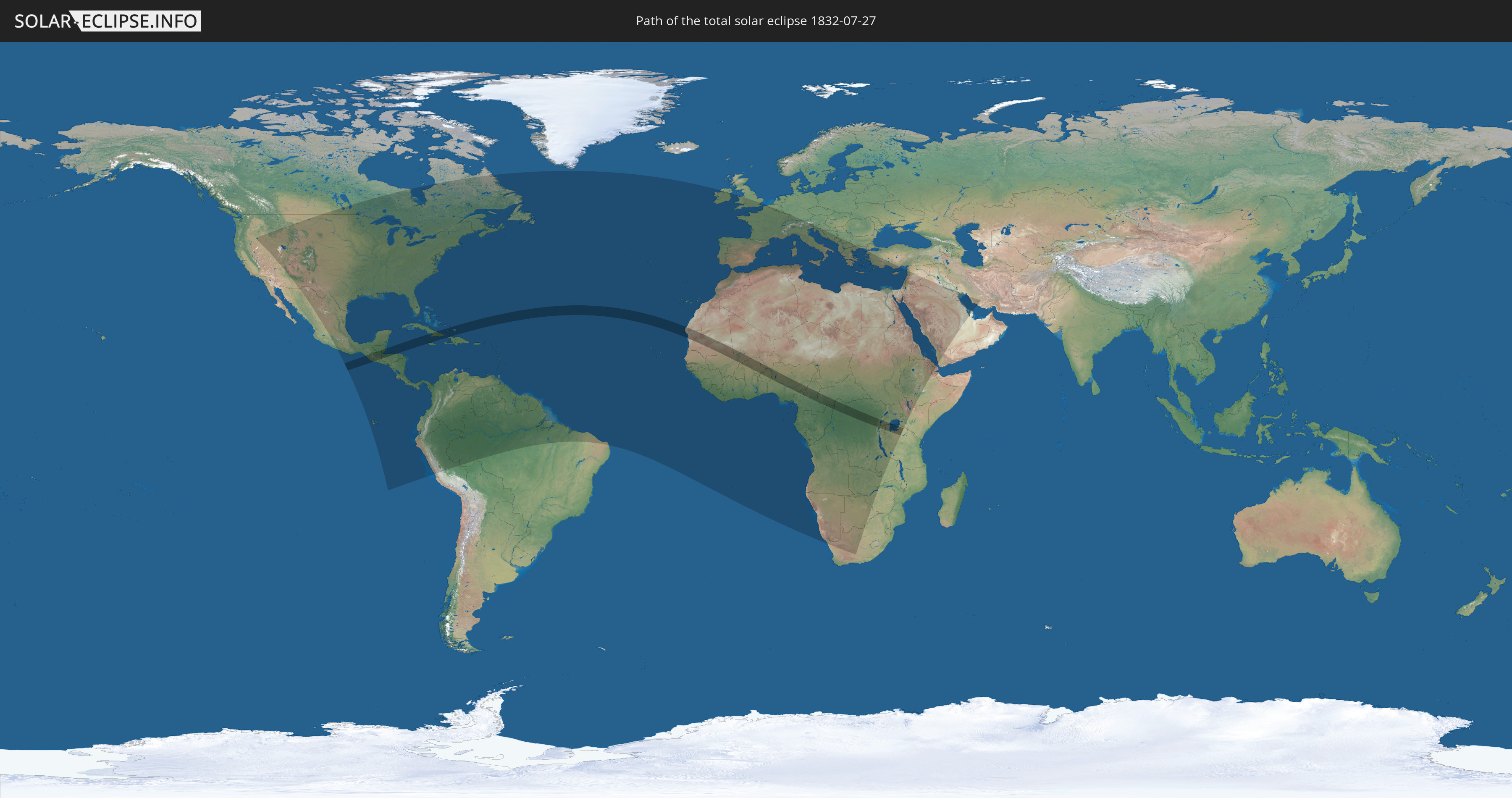
Die Sonnenfinsternis am 27.07.1832 kann man in 134 Ländern als partielle Sonnenfinsternis beobachten.
Der Finsternispfad verläuft durch 23 Länder. Nur in diesen Ländern ist sie als totale Sonnenfinsternis zu sehen.
In den folgenden Ländern ist die Sonnenfinsternis total zu sehen
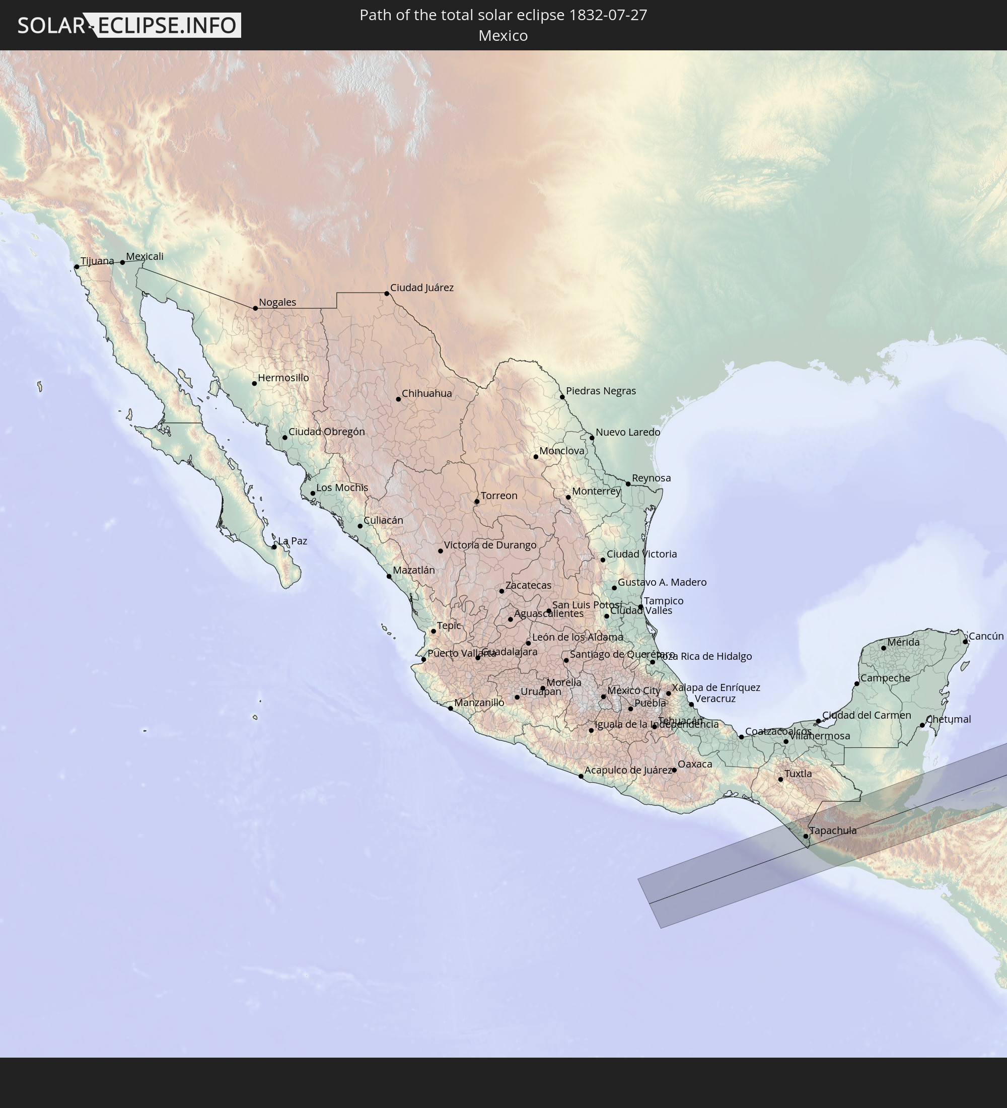 Mexiko
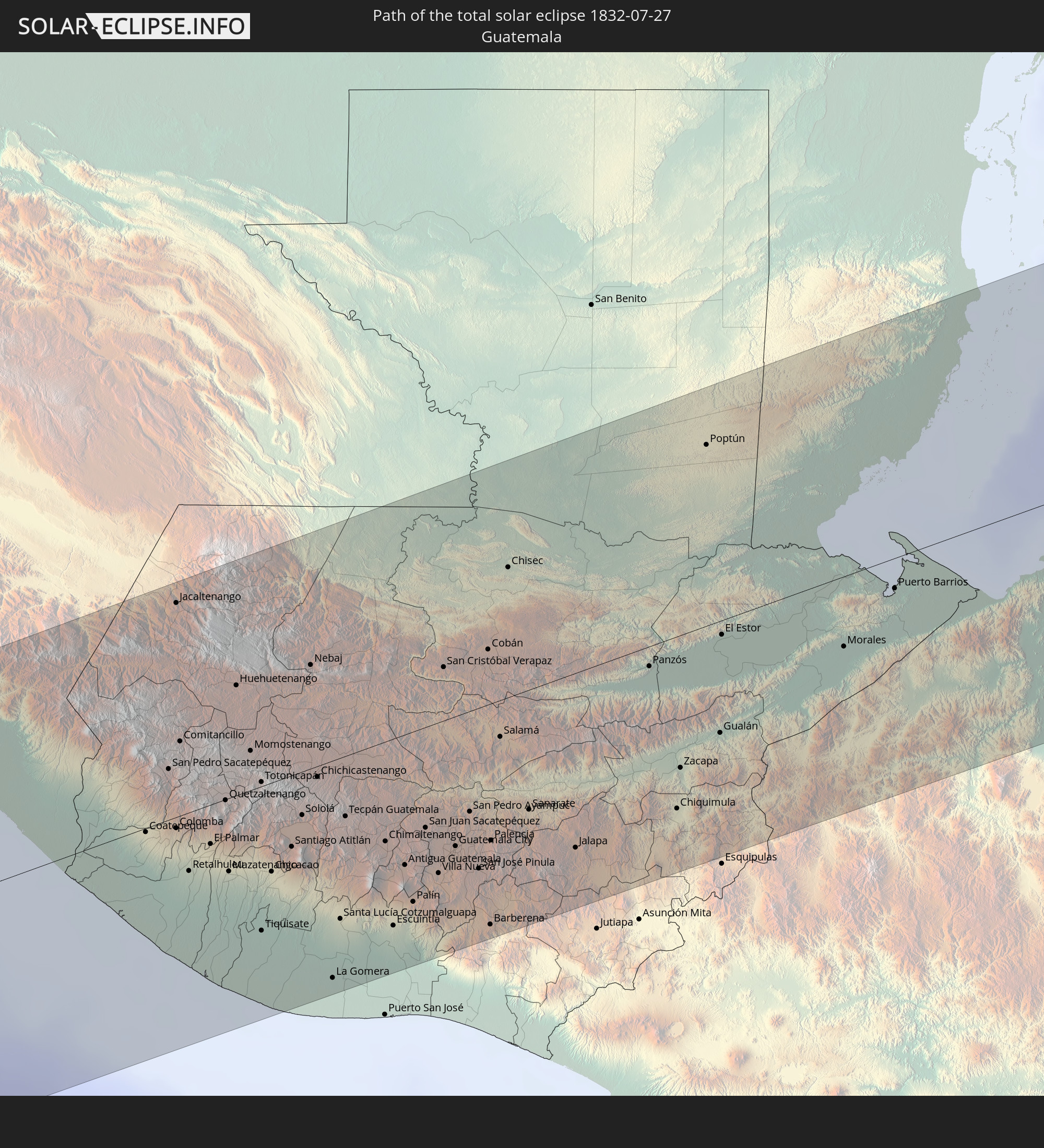 Guatemala
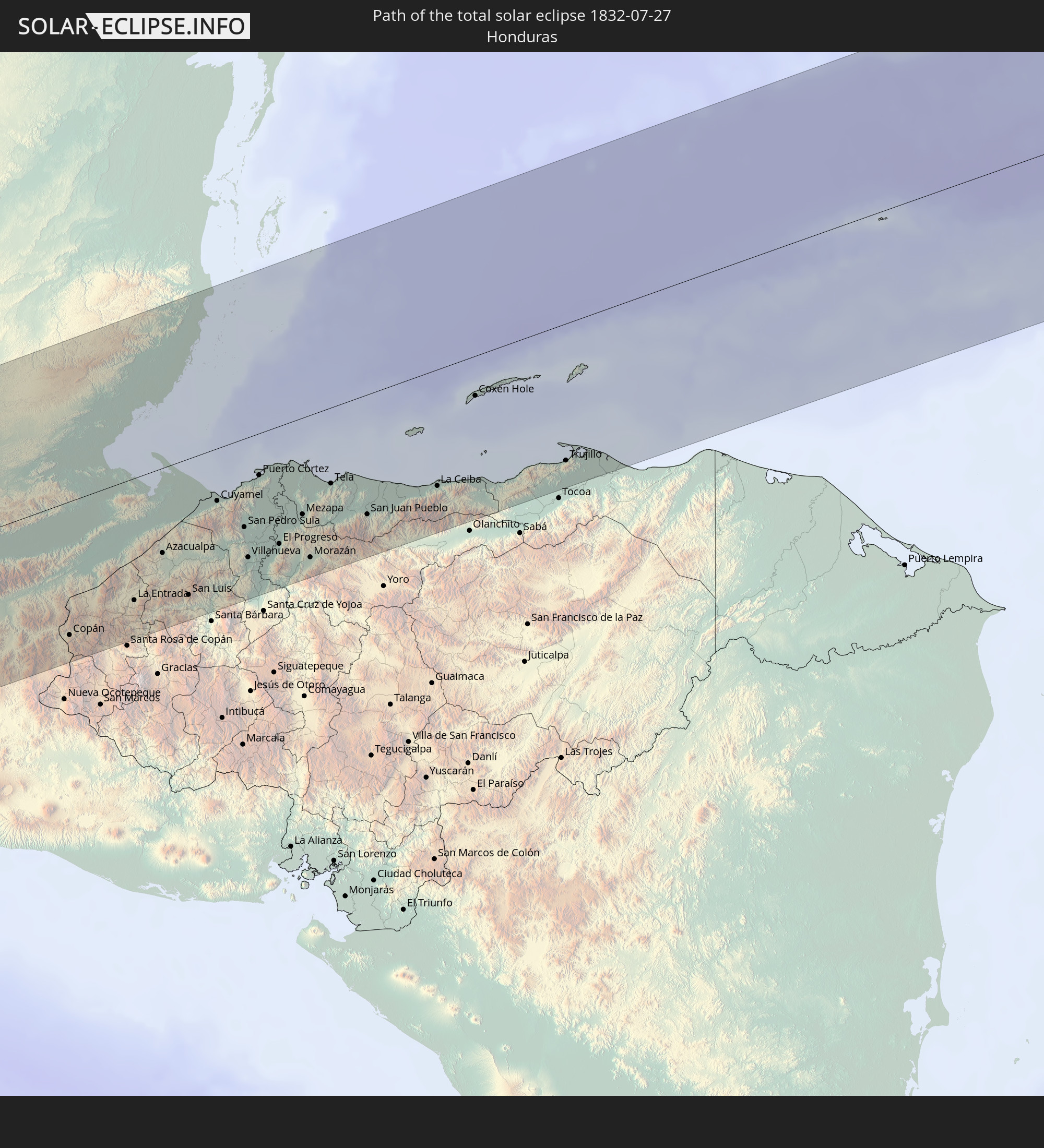 Honduras
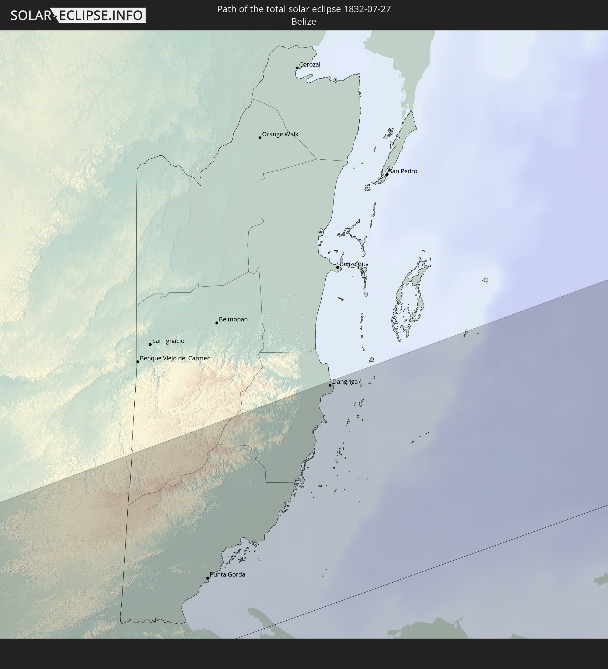 Belize
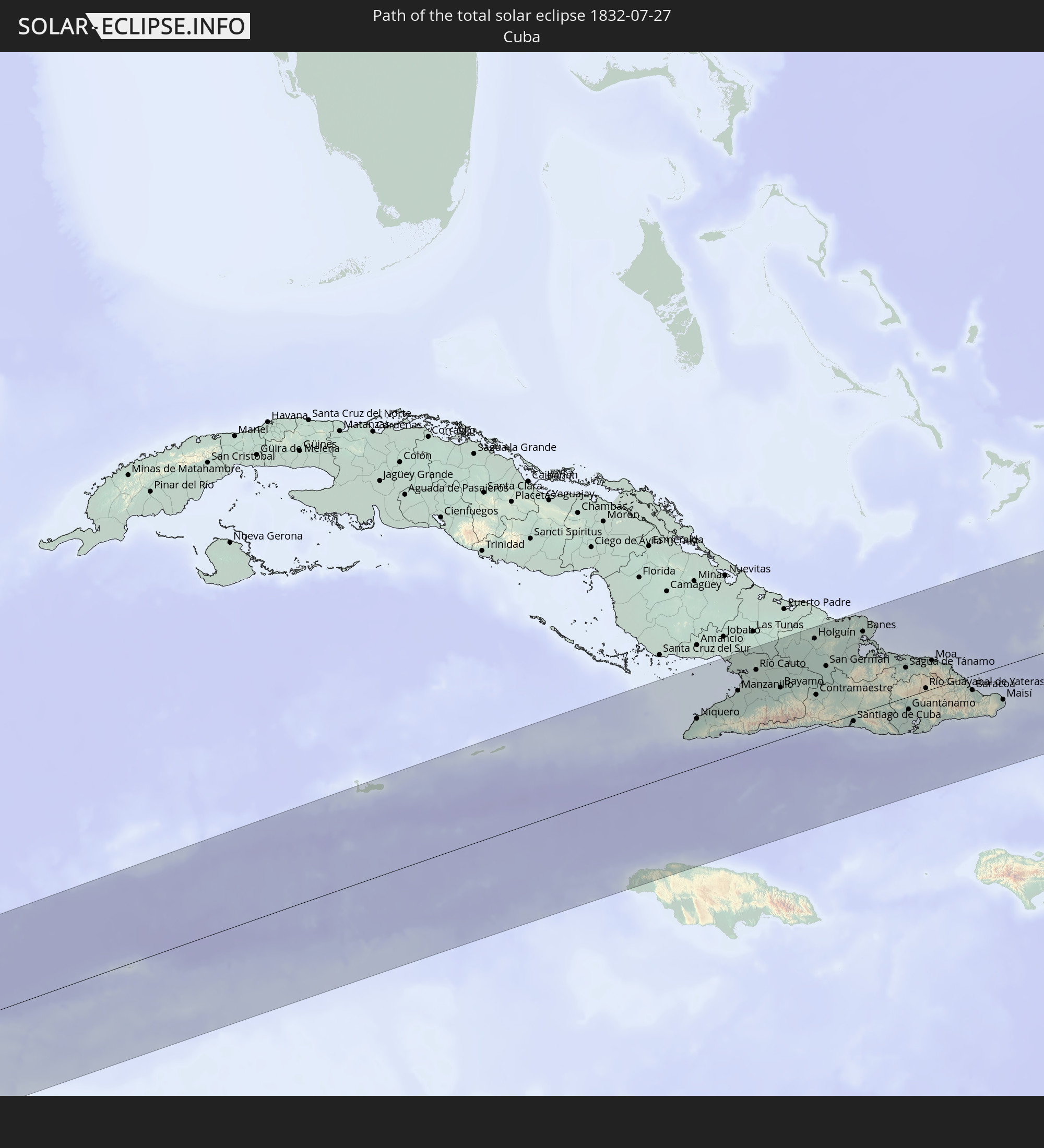 Kuba
Kuba
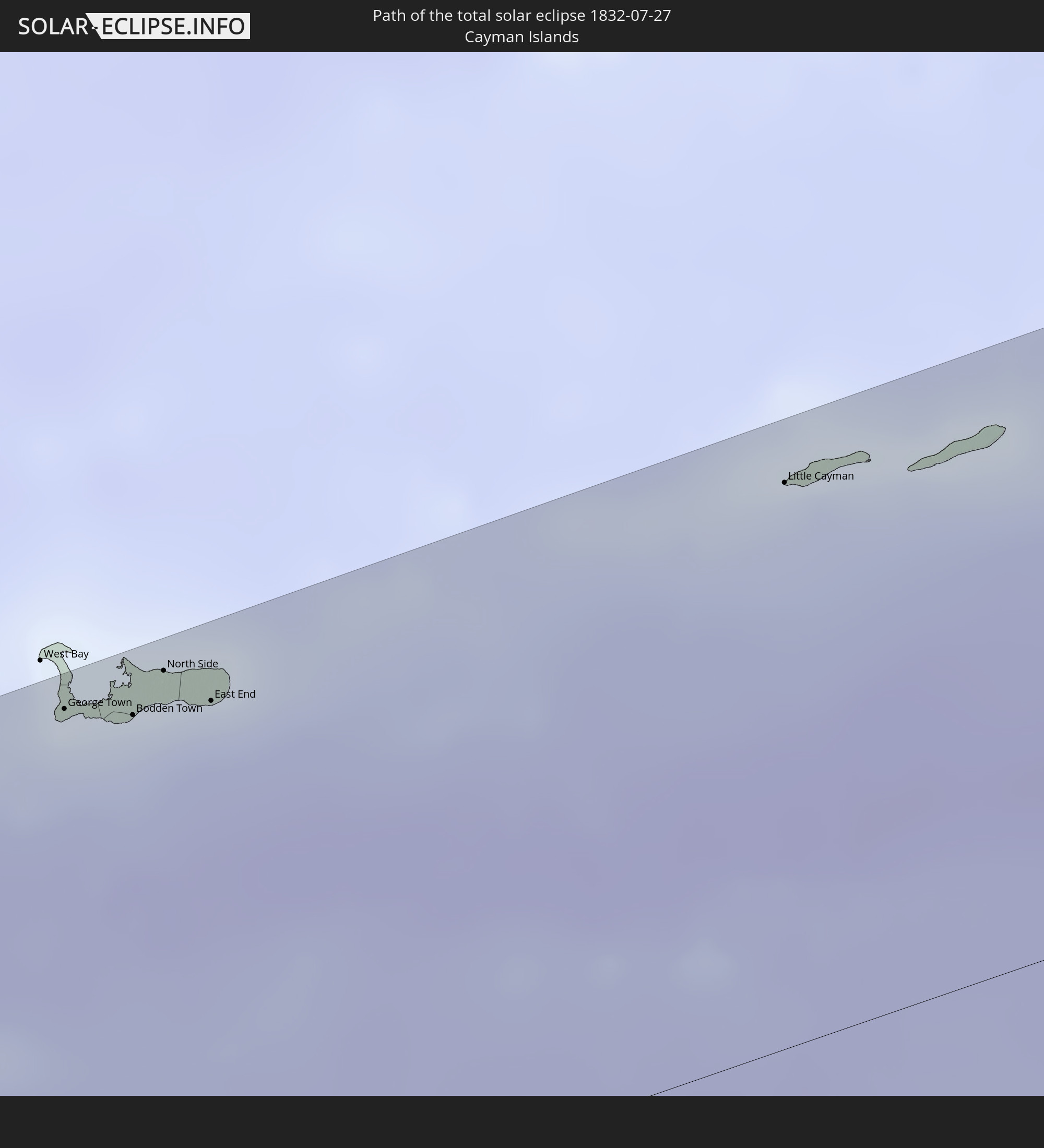 Kaimaninseln
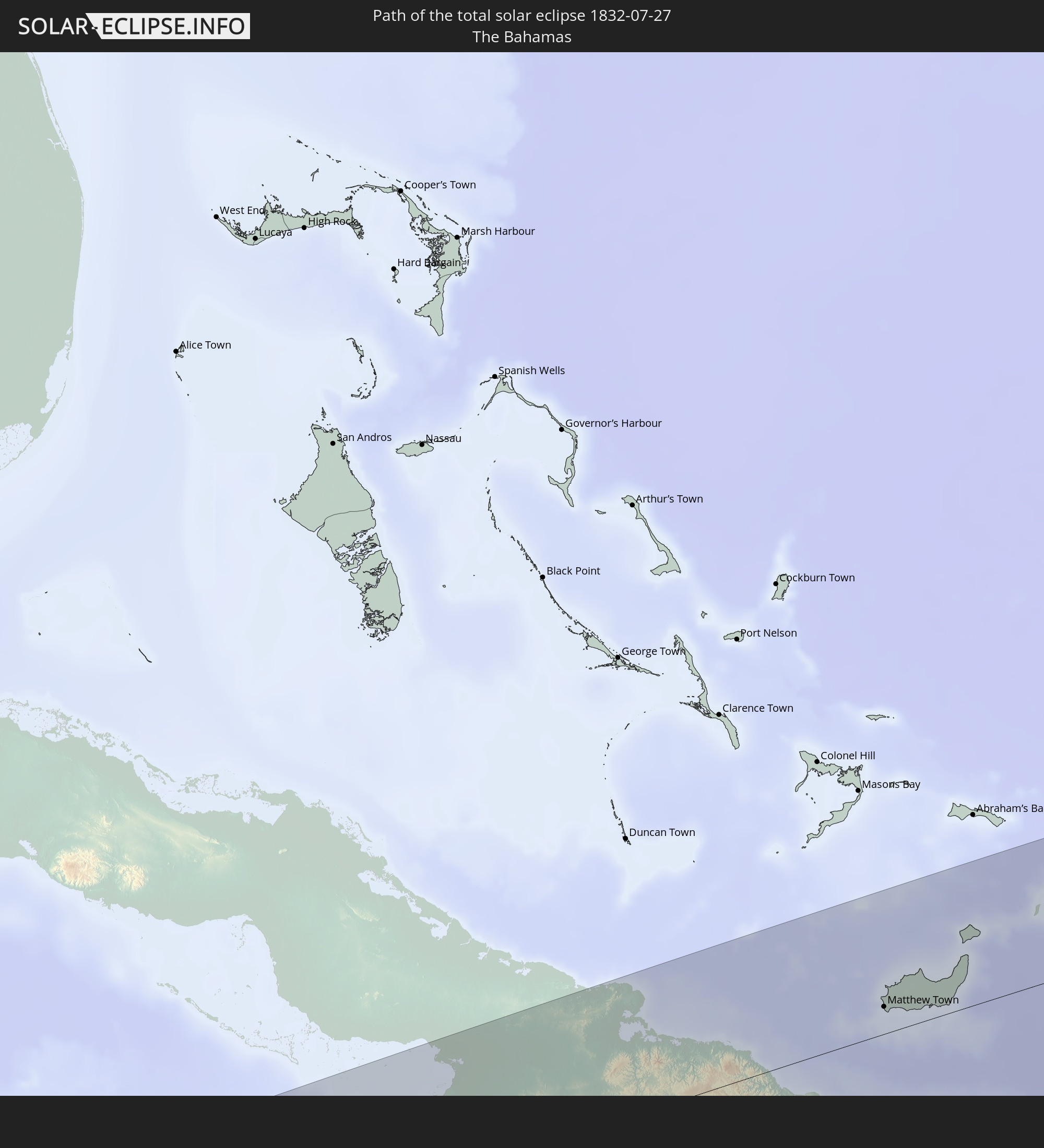 Bahamas
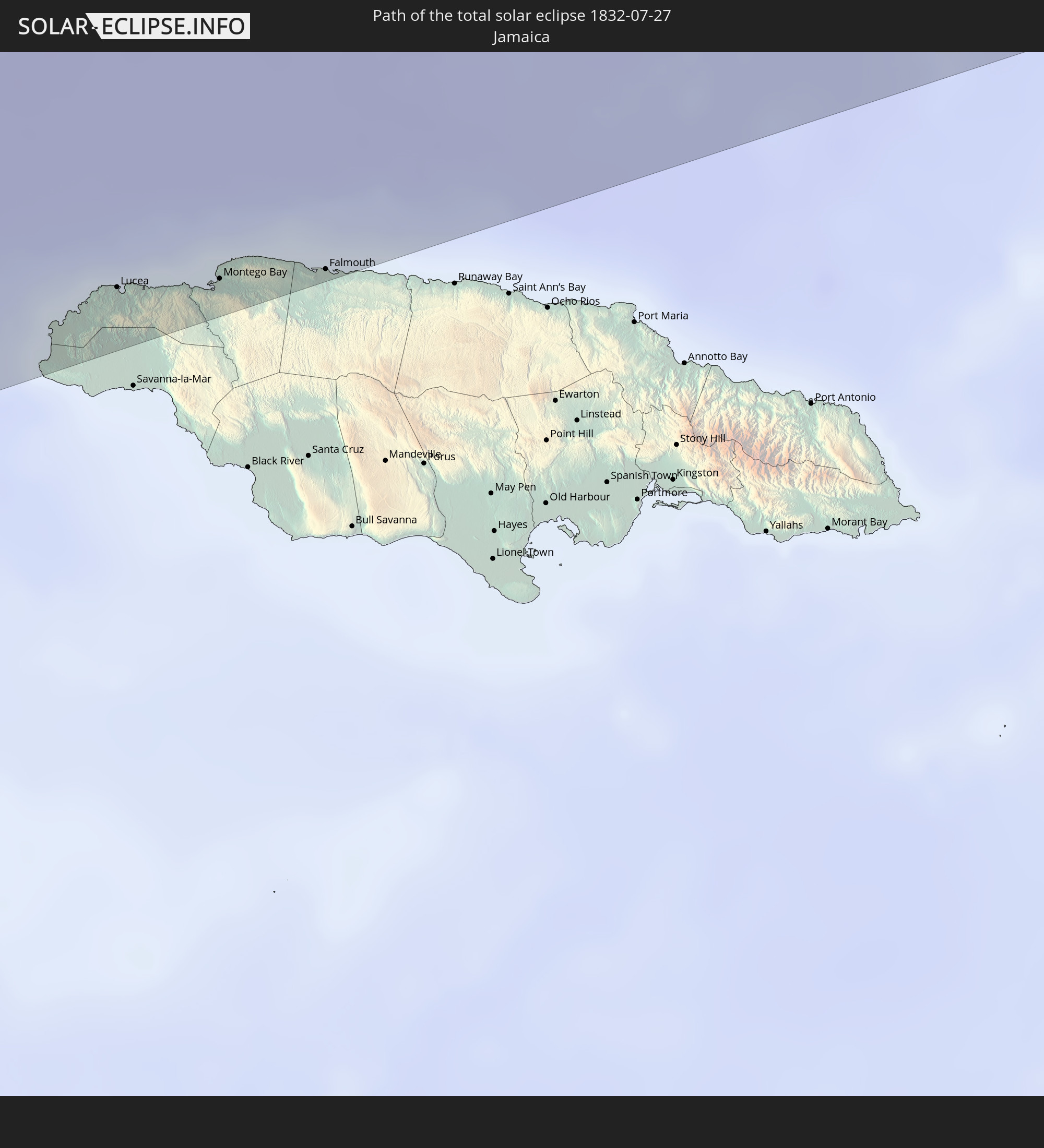 Jamaika
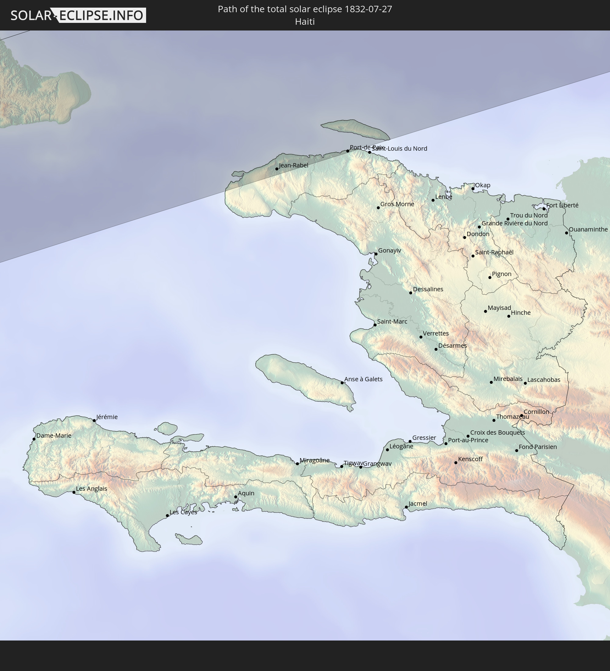 Haiti
Haiti
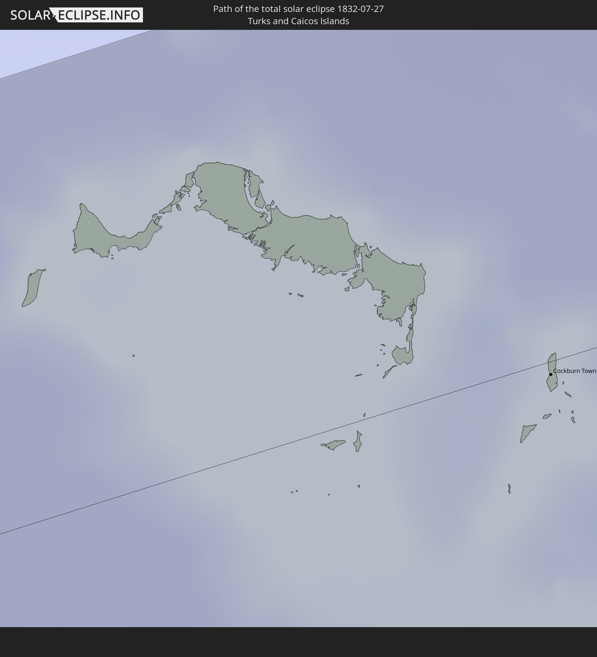 Turks- und Caicosinseln
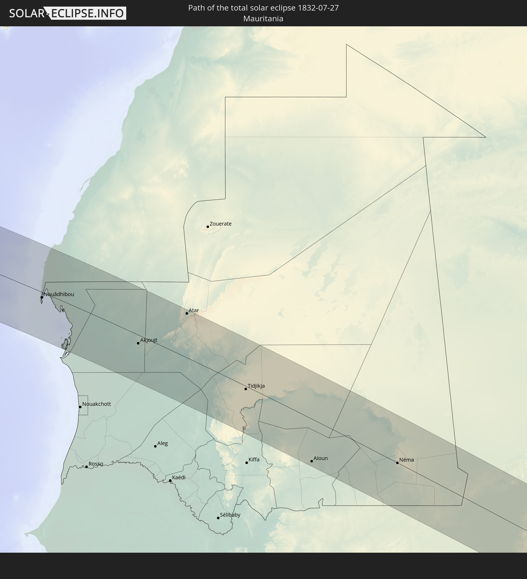 Mauretanien
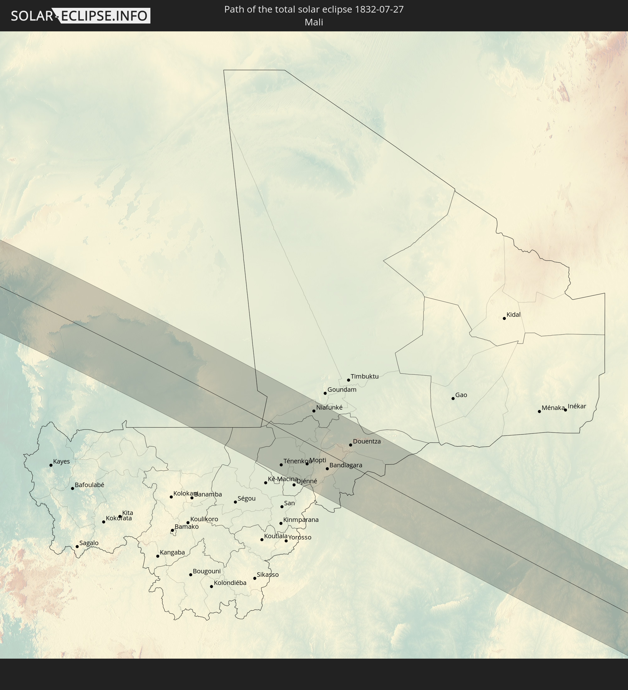 Mali
Mali
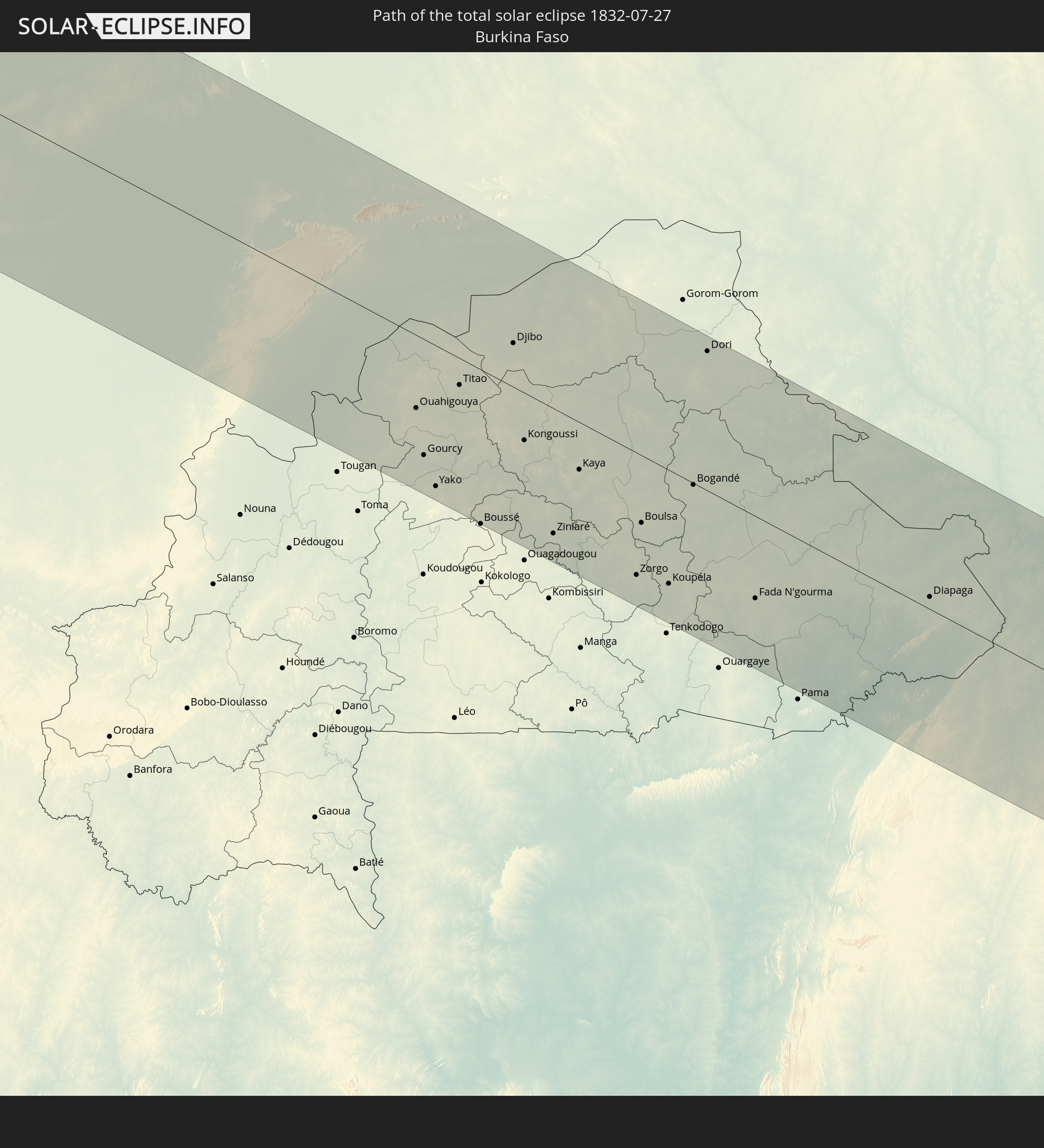 Burkina Faso
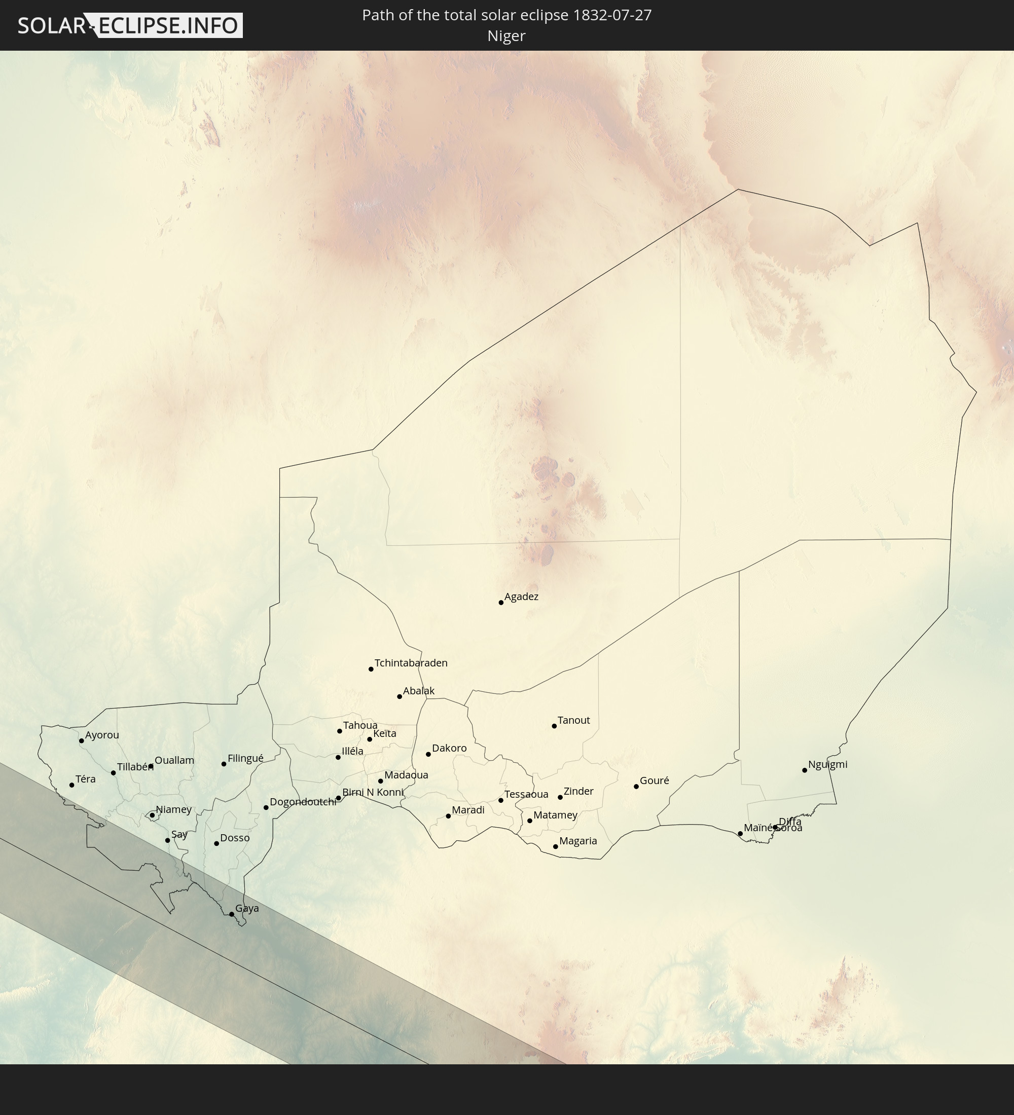 Niger
Niger
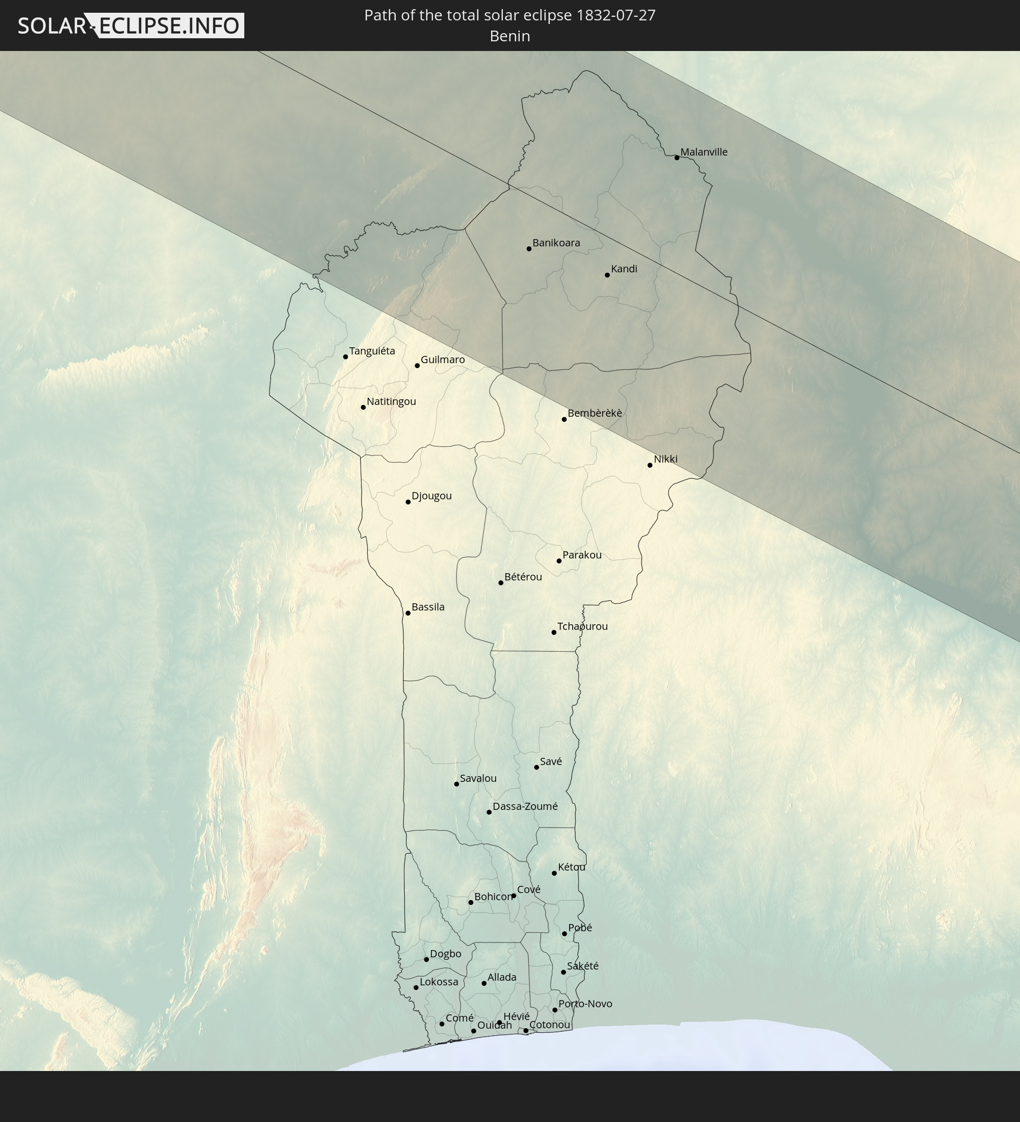 Benin
Benin
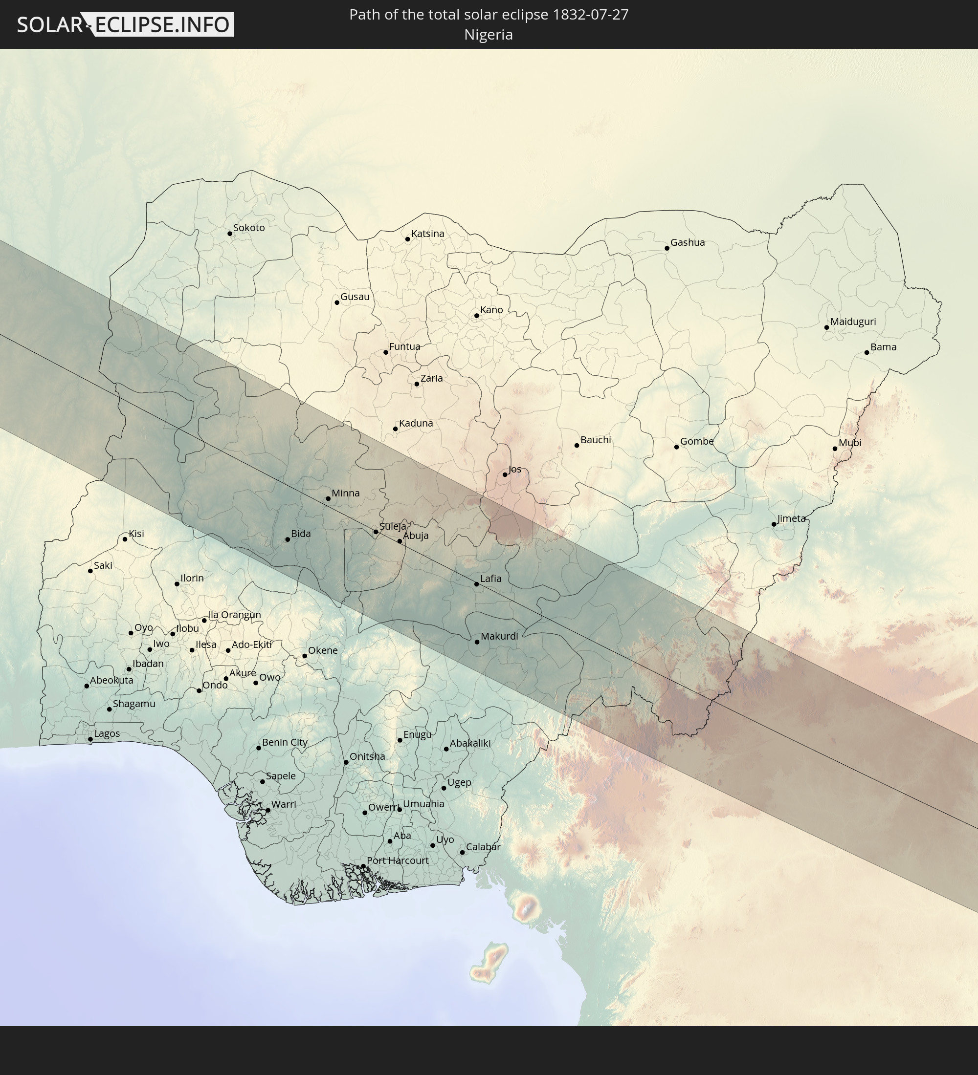 Nigeria
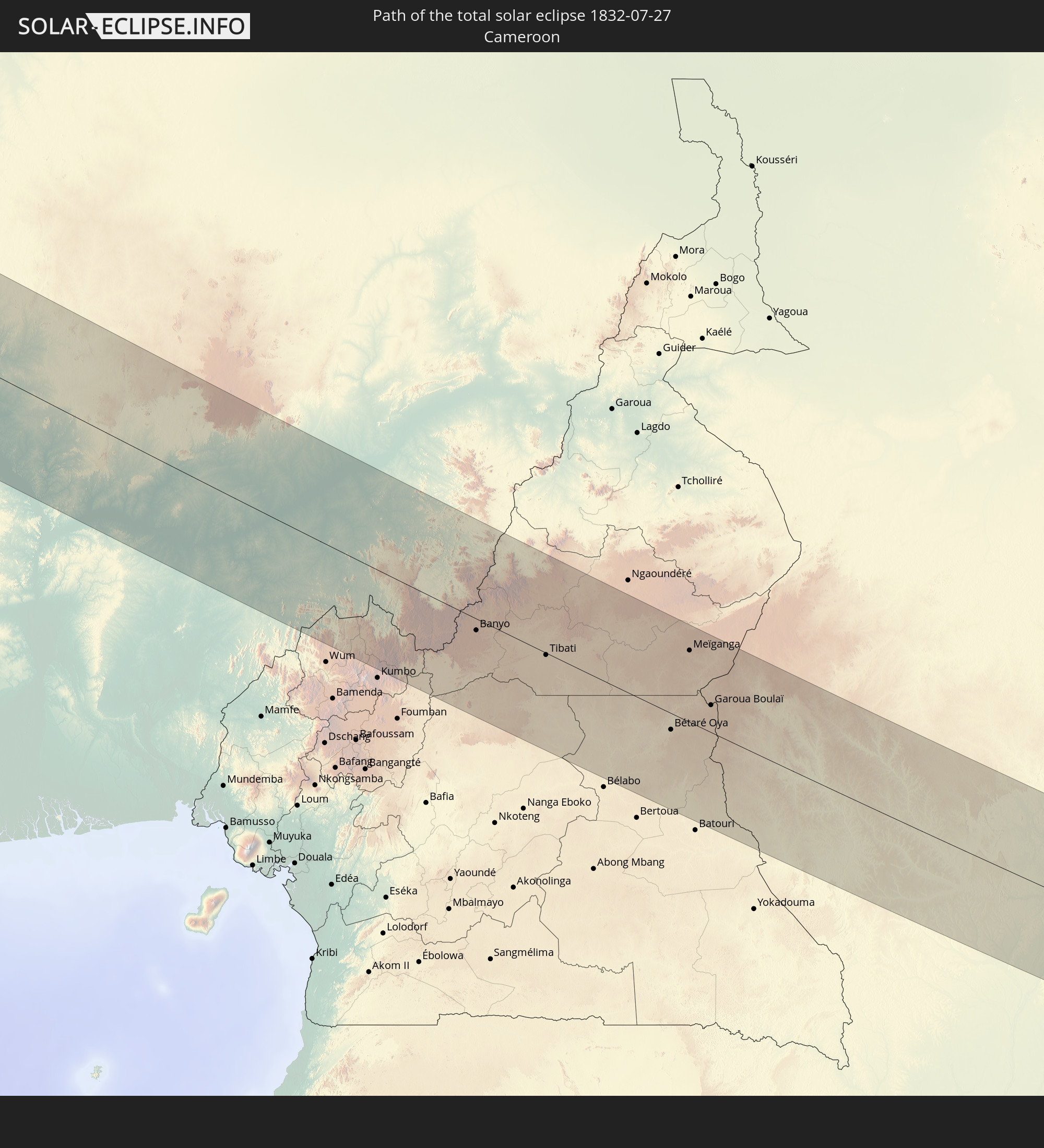 Kamerun
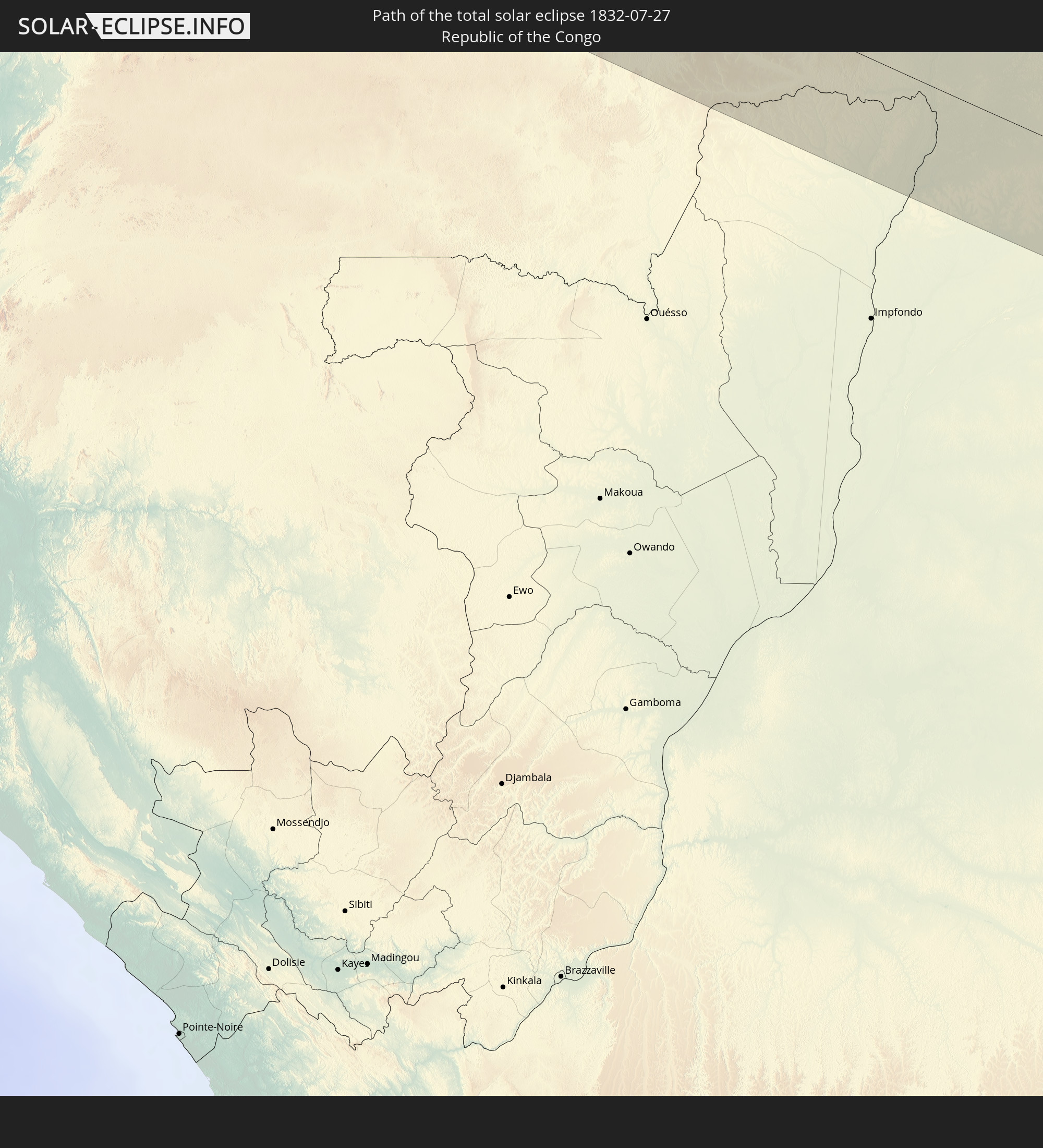 Republik Kongo
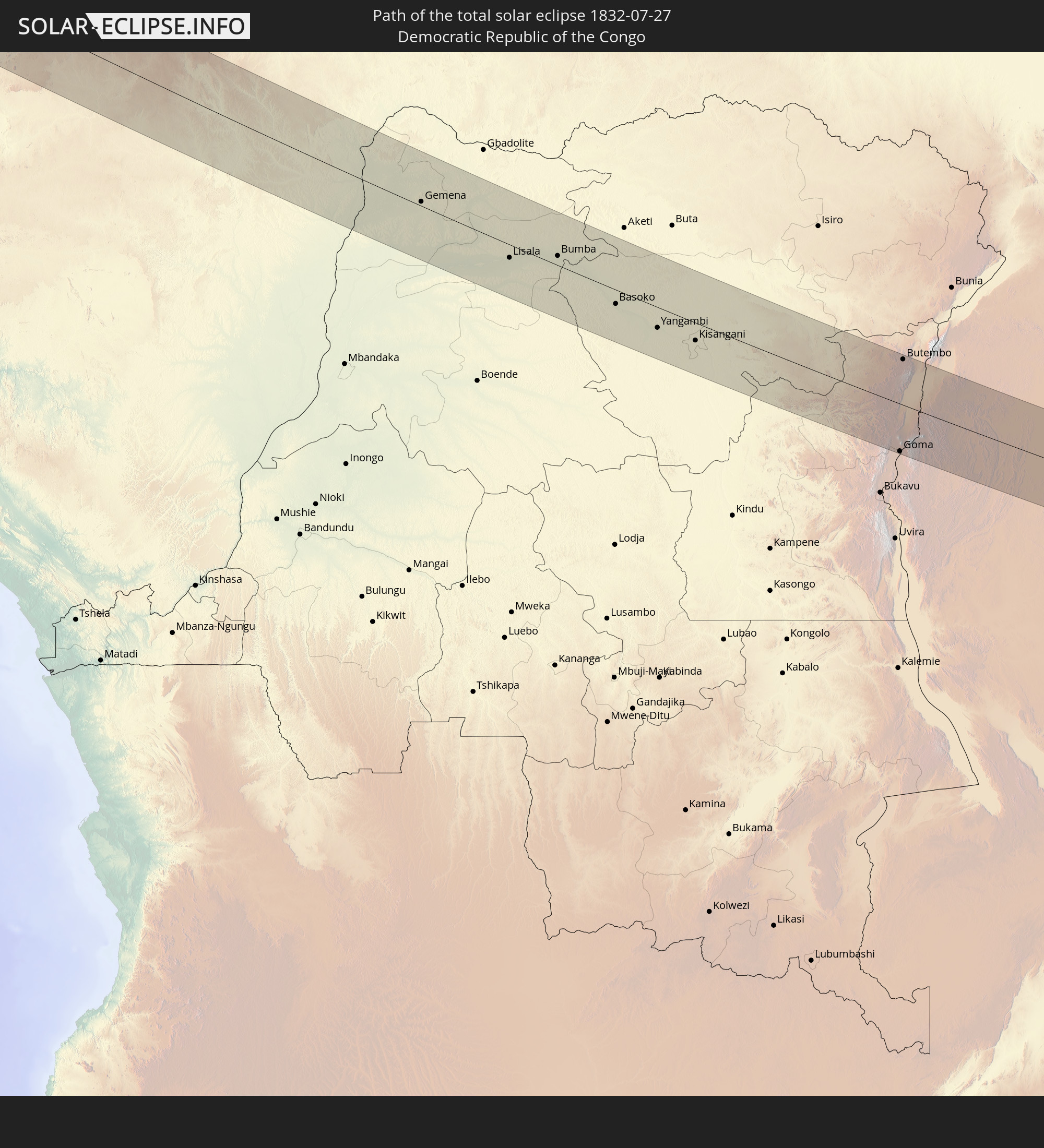 Demokratische Republik Kongo
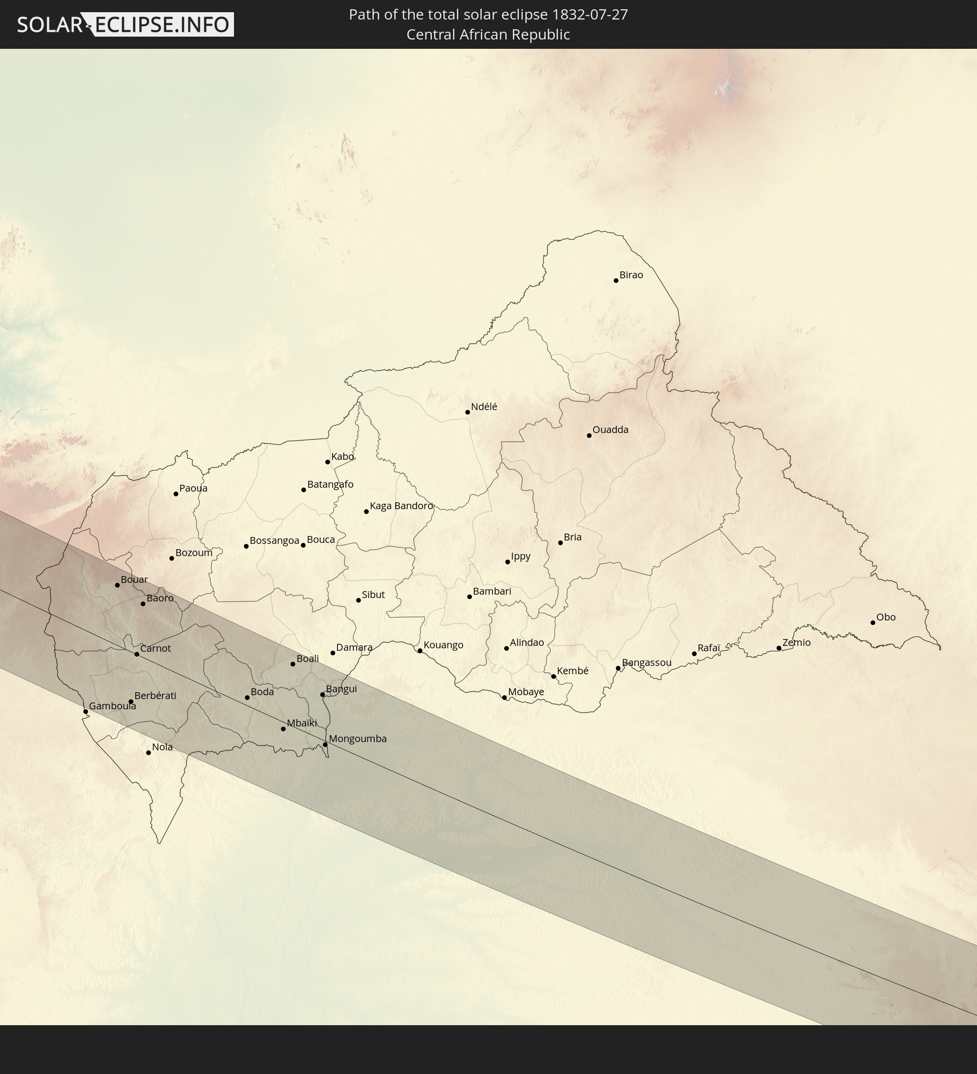 Zentralafrikanische Republik
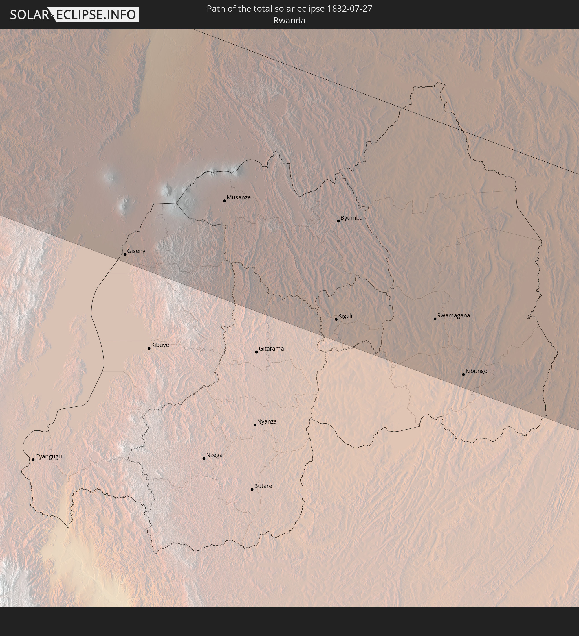 Ruanda
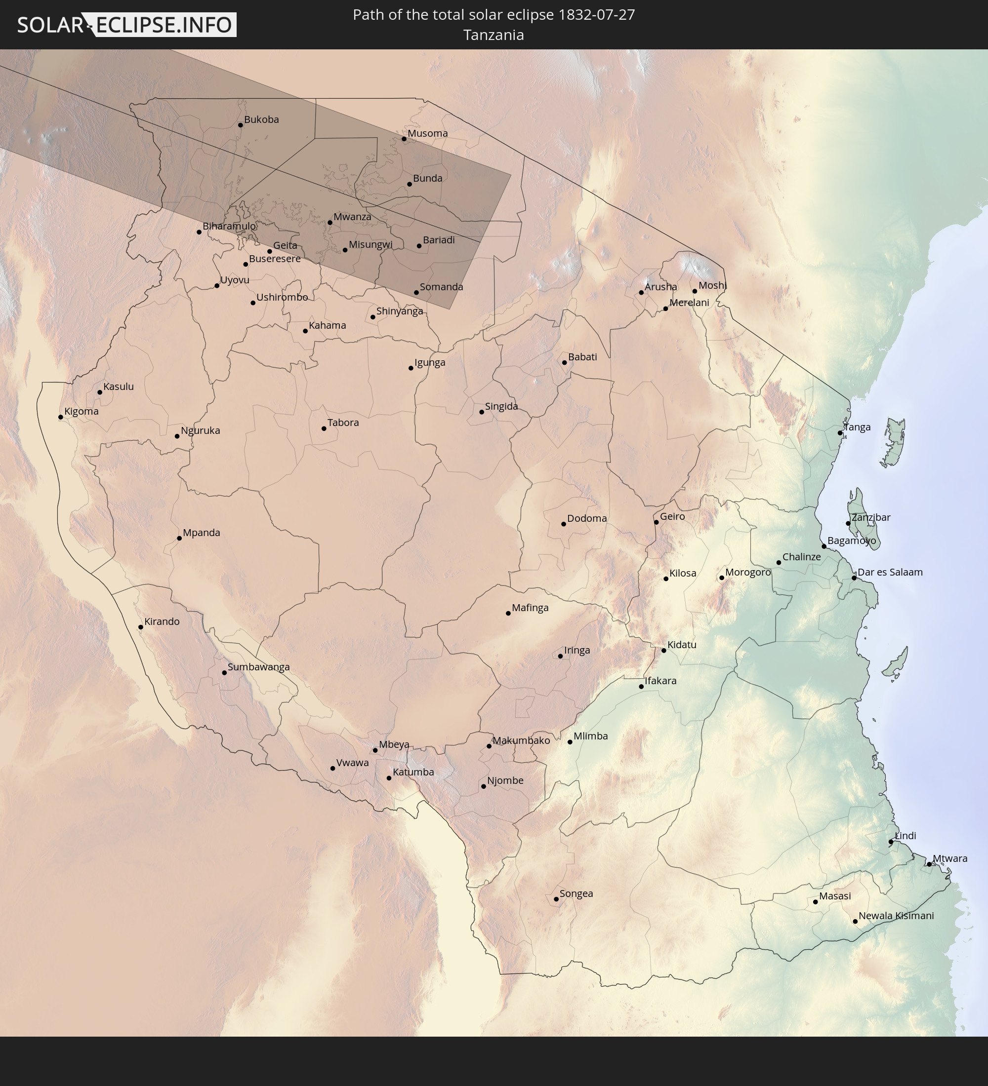 Tansania
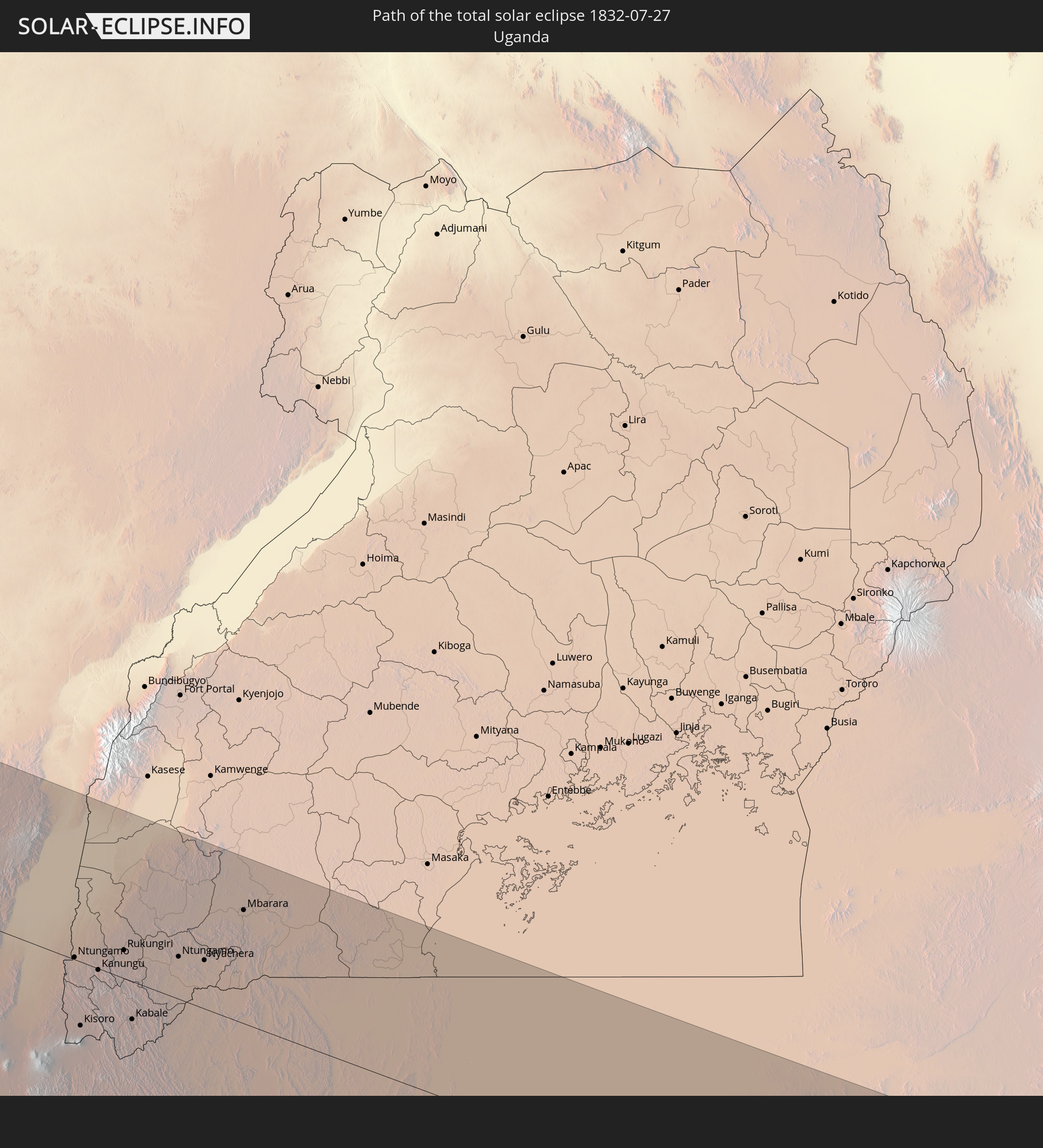 Uganda
In den folgenden Ländern ist die Sonnenfinsternis partiell zu sehen
 Vereinigte Staaten
 United States Minor Outlying Islands
 Kanada
 Mexiko
 Guatemala
 Ecuador
 El Salvador
 Honduras
 Belize
 Nicaragua
 Costa Rica
 Kuba
Kuba
 Panama
 Kolumbien
 Kaimaninseln
 Peru
Peru
 Bahamas
 Jamaika
 Haiti
Haiti
 Brasilien
 Venezuela
 Turks- und Caicosinseln
 Dominikanische Republik
 Aruba
Aruba
 Puerto Rico
 Amerikanische Jungferninseln
 Bermuda
 Britische Jungferninseln
 Anguilla
 Saint-Martin
 Saint-Barthélemy
 St. Kitts und Nevis
 Antigua und Barbuda
 Montserrat
 Trinidad und Tobago
 Guadeloupe
 Grenada
 Dominica
 St. Vincent und die Grenadinen
 Guyana
 Martinique
 St. Lucia
 Barbados
 Suriname
 Saint-Pierre und Miquelon
 Französisch-Guayana
 Portugal
 Kap Verde
 Spanien
 Senegal
 Mauretanien
 Gambia
 Guinea-Bissau
 Guinea
 St. Helena
 Sierra Leone
 Marokko
 Mali
Mali
 Liberia
 Irland
 Algerien
 Vereinigtes Königreich
 Elfenbeinküste
 Burkina Faso
 Gibraltar
 Frankreich
 Ghana
Ghana
 Guernsey
 Jersey
 Togo
Togo
 Niger
Niger
 Benin
Benin
 Andorra
 Belgien
 Nigeria
 Äquatorialguinea
 Luxemburg
 Deutschland
 Schweiz
 São Tomé und Príncipe
 Italien
 Monaco
 Tunesien
 Kamerun
 Gabun
Gabun
 Libyen
 Liechtenstein
 Österreich
 Republik Kongo
 Angola
 Namibia
 Demokratische Republik Kongo
 San Marino
 Vatikanstadt
 Slowenien
 Tschad
 Kroatien
 Malta
Malta
 Zentralafrikanische Republik
 Bosnien und Herzegowina
 Südafrika
 Montenegro
 Serbien
 Albanien
 Griechenland
 Botswana
 Mazedonien
 Sudan
Sudan
 Sambia
 Bulgarien
 Ägypten
 Simbabwe
 Türkei
 Ruanda
 Burundi
 Tansania
 Uganda
 Republik Zypern
 Äthiopien
 Kenia
Kenia
 Staat Palästina
 Israel
 Saudi-Arabien
 Jordanien
 Libanon
 Syrien
 Eritrea
 Irak
Irak
 Dschibuti
 Jemen
Jemen
 Iran
Iran
 Kuwait
 Bahrain
 Katar
Katar
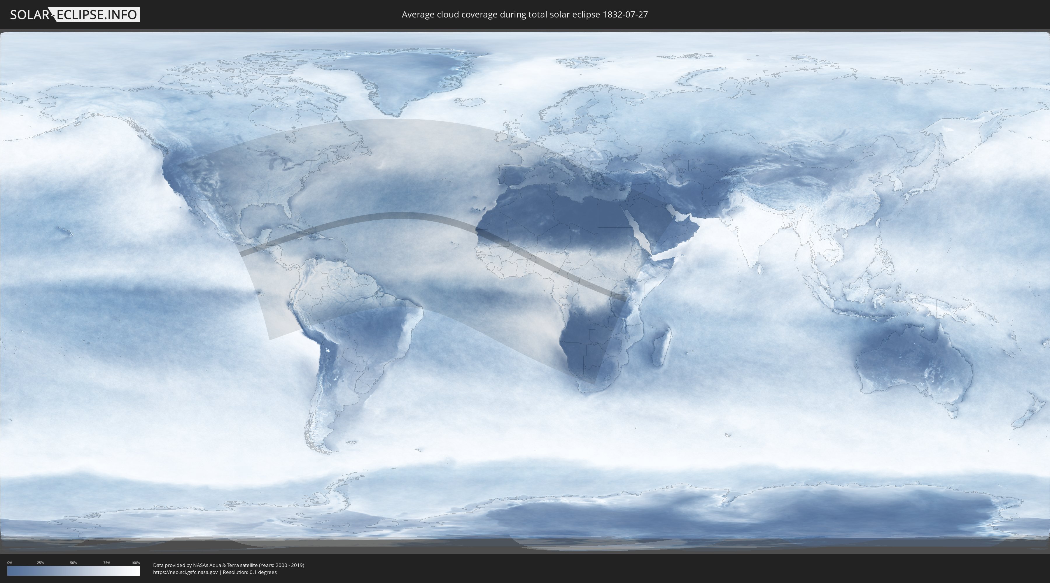
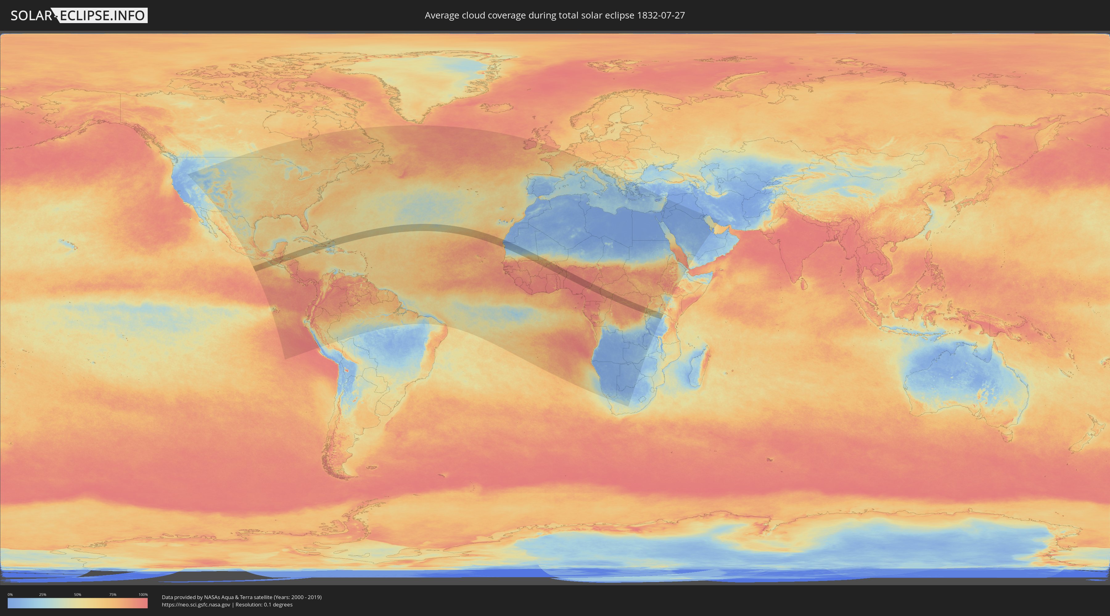
Wie wird das Wetter während der totalen Sonnenfinsternis am 27.07.1832?
Wo ist der beste Ort, um die totale Sonnenfinsternis vom 27.07.1832 zu beobachten?
Die folgenden Karten zeigen die durchschnittliche Bewölkung für den Tag, an dem die totale Sonnenfinsternis
stattfindet. Mit Hilfe der Karten lässt sich der Ort entlang des Finsternispfades eingrenzen,
der die besten Aussichen auf einen klaren wolkenfreien Himmel bietet.
Trotzdem muss man immer lokale Gegenenheiten beachten und sollte sich genau über das Wetter an seinem
gewählten Beobachtungsort informieren.
Die Daten stammen von den beiden NASA-Satelliten
AQUA und TERRA
und wurden über einen Zeitraum von 19 Jahren (2000 - 2019) gemittelt.
Detaillierte Länderkarten
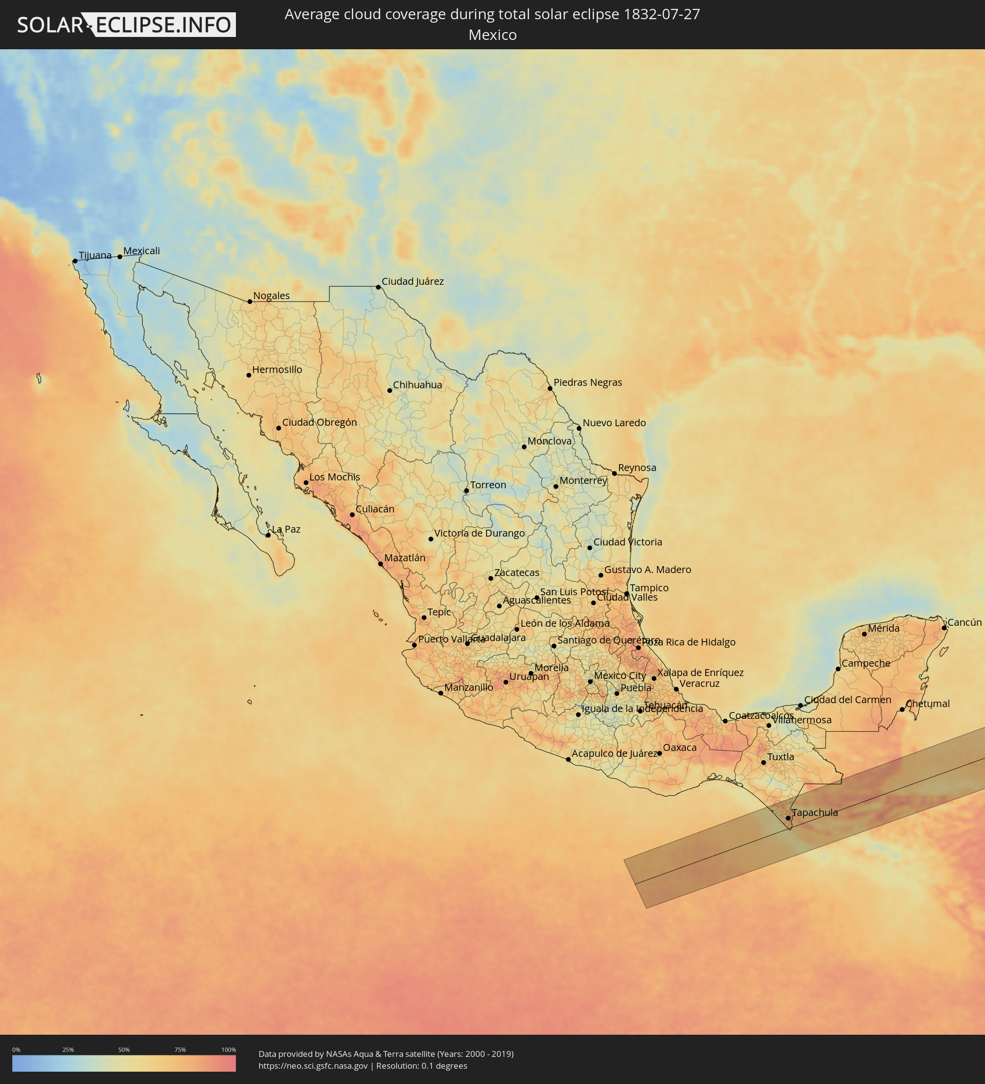 Mexiko
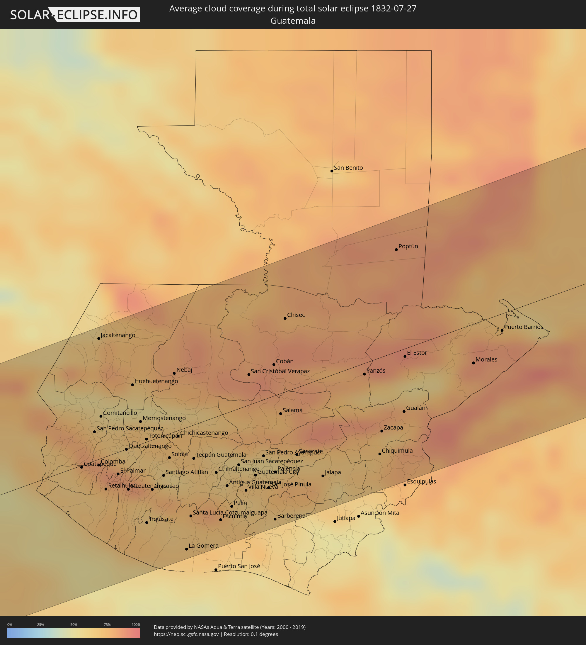 Guatemala
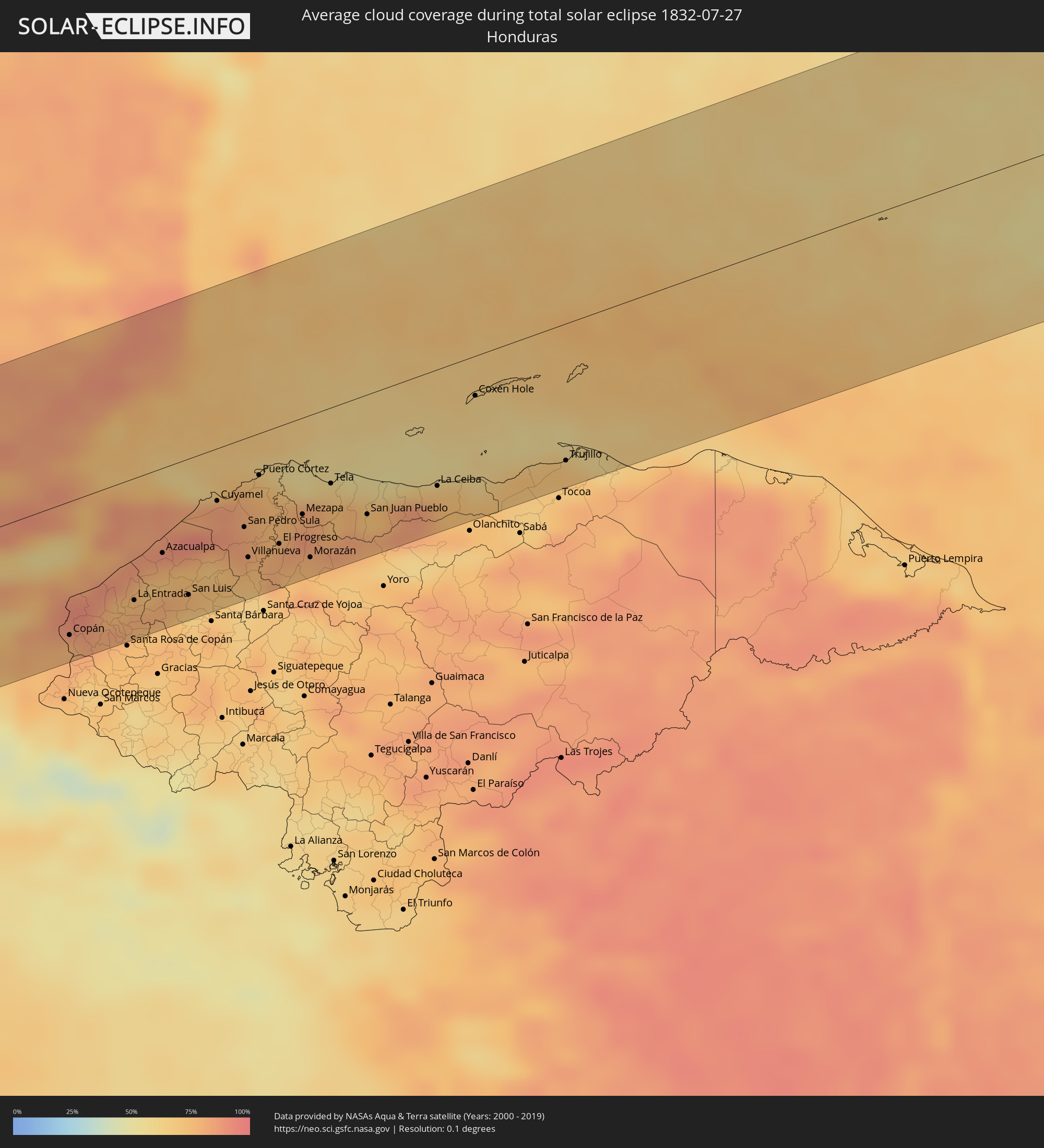 Honduras
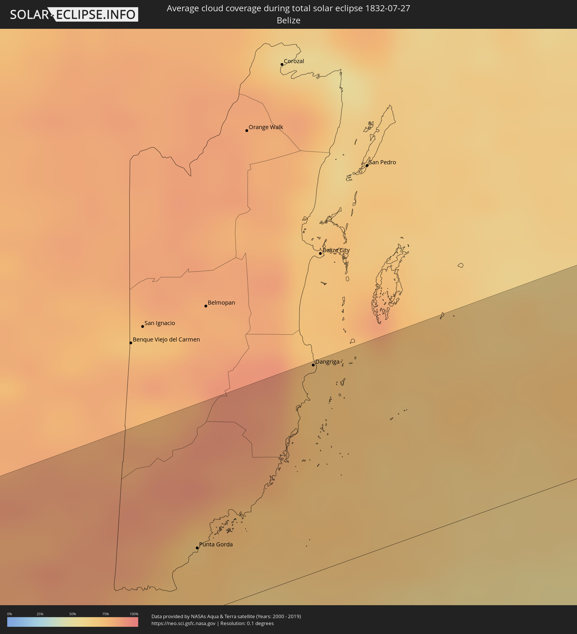 Belize
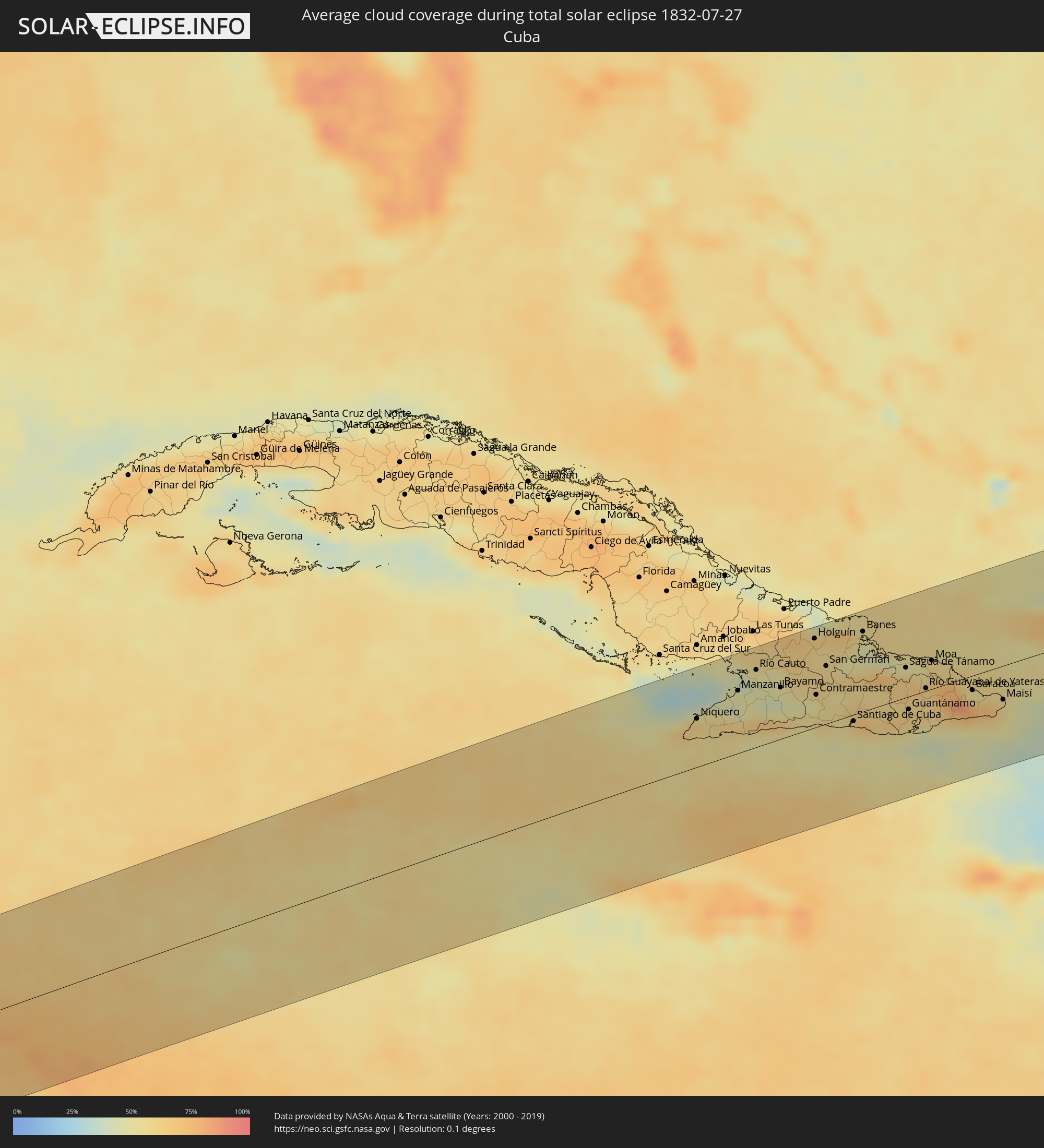 Kuba
Kuba
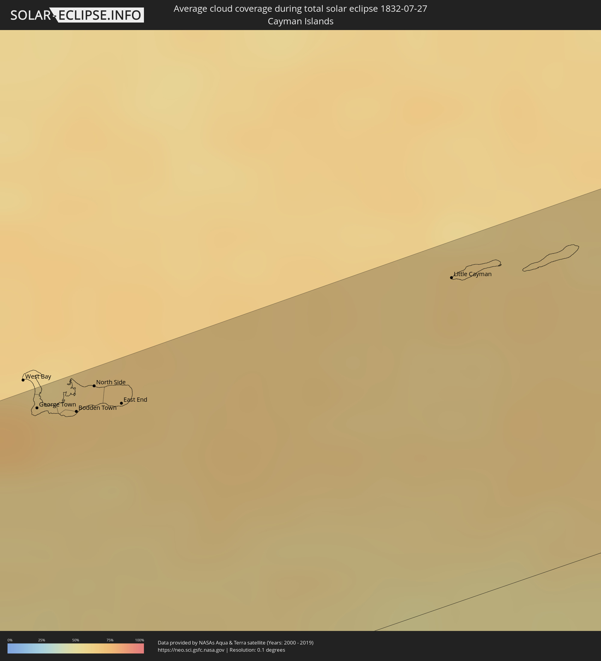 Kaimaninseln
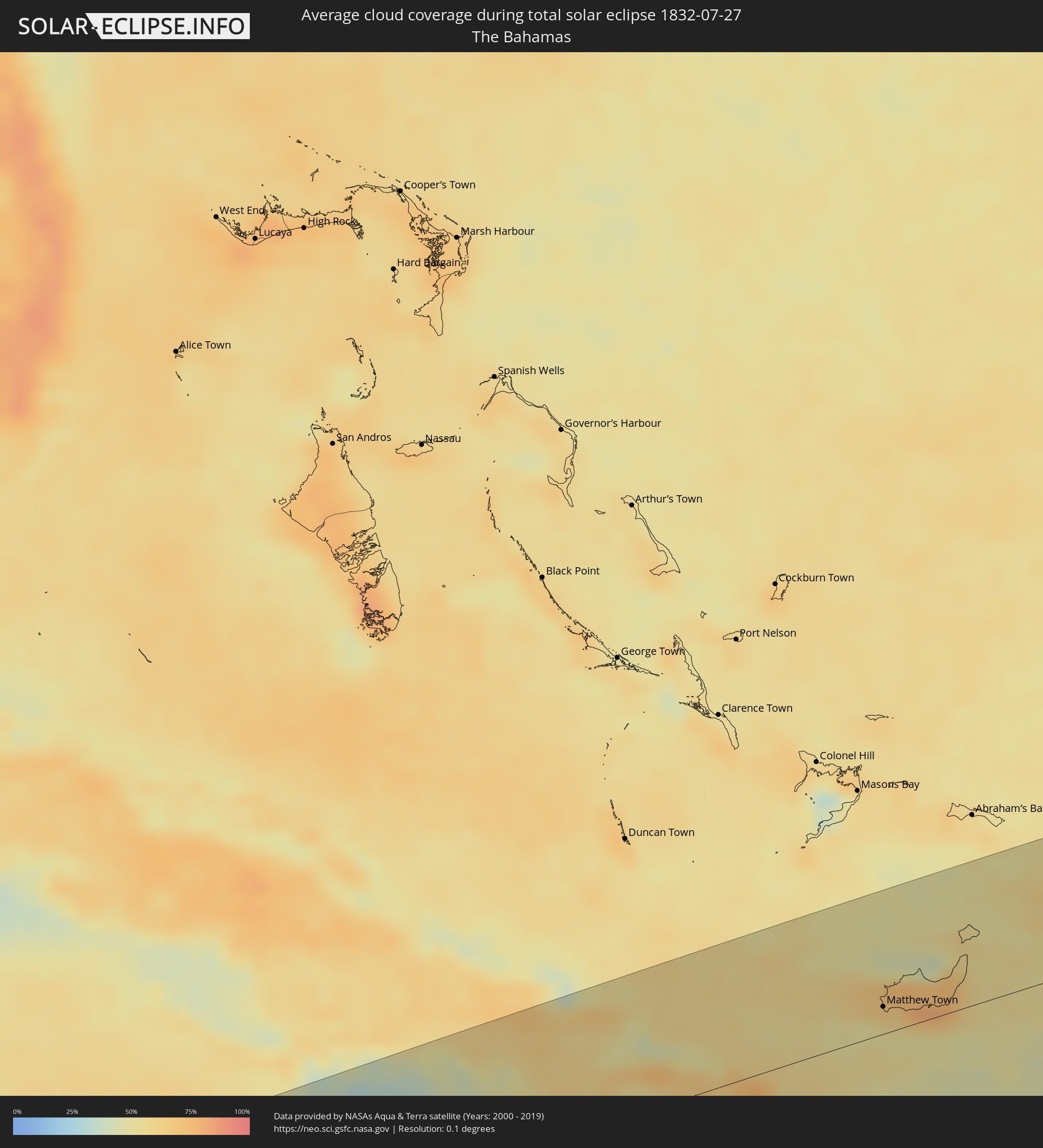 Bahamas
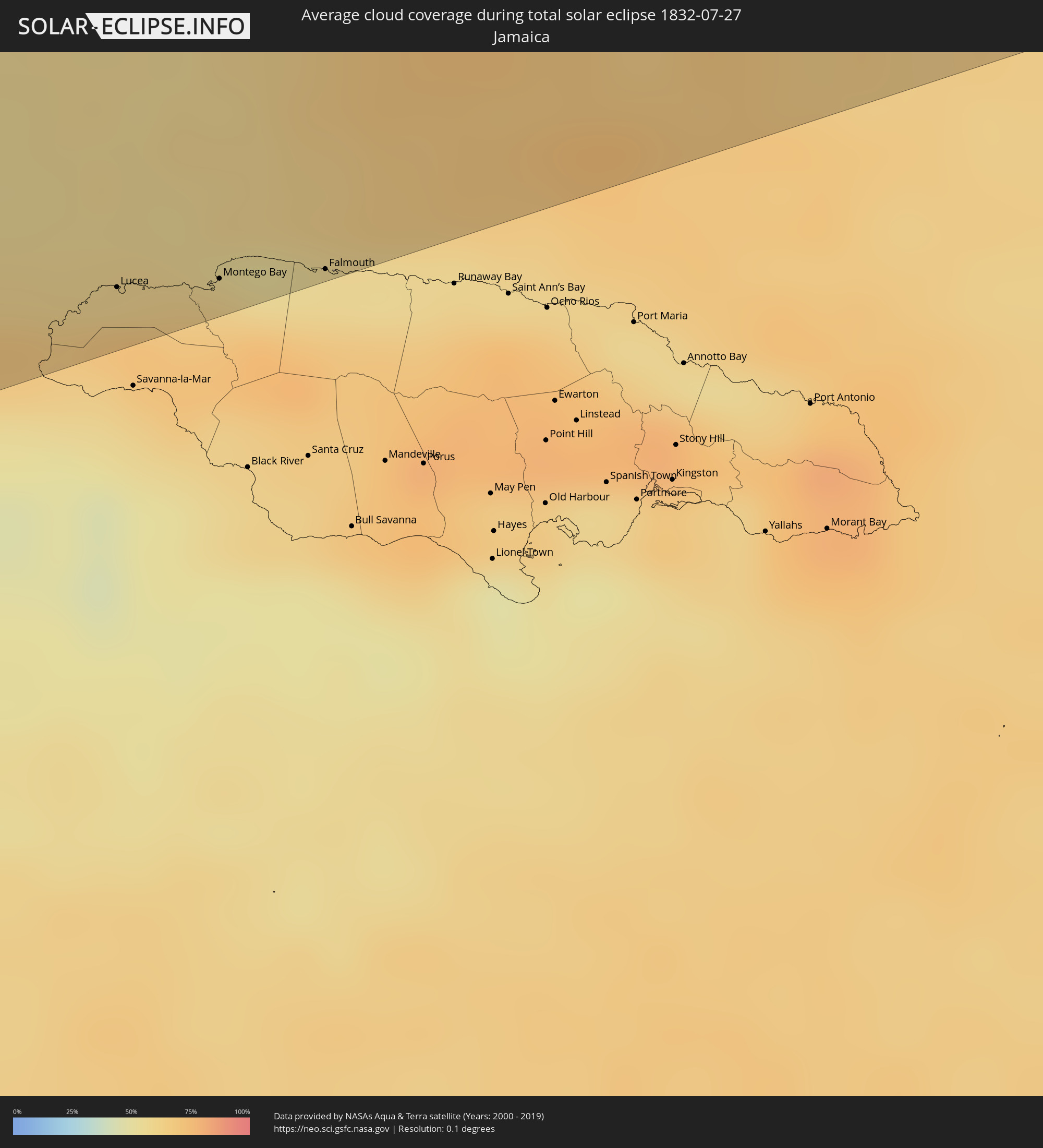 Jamaika
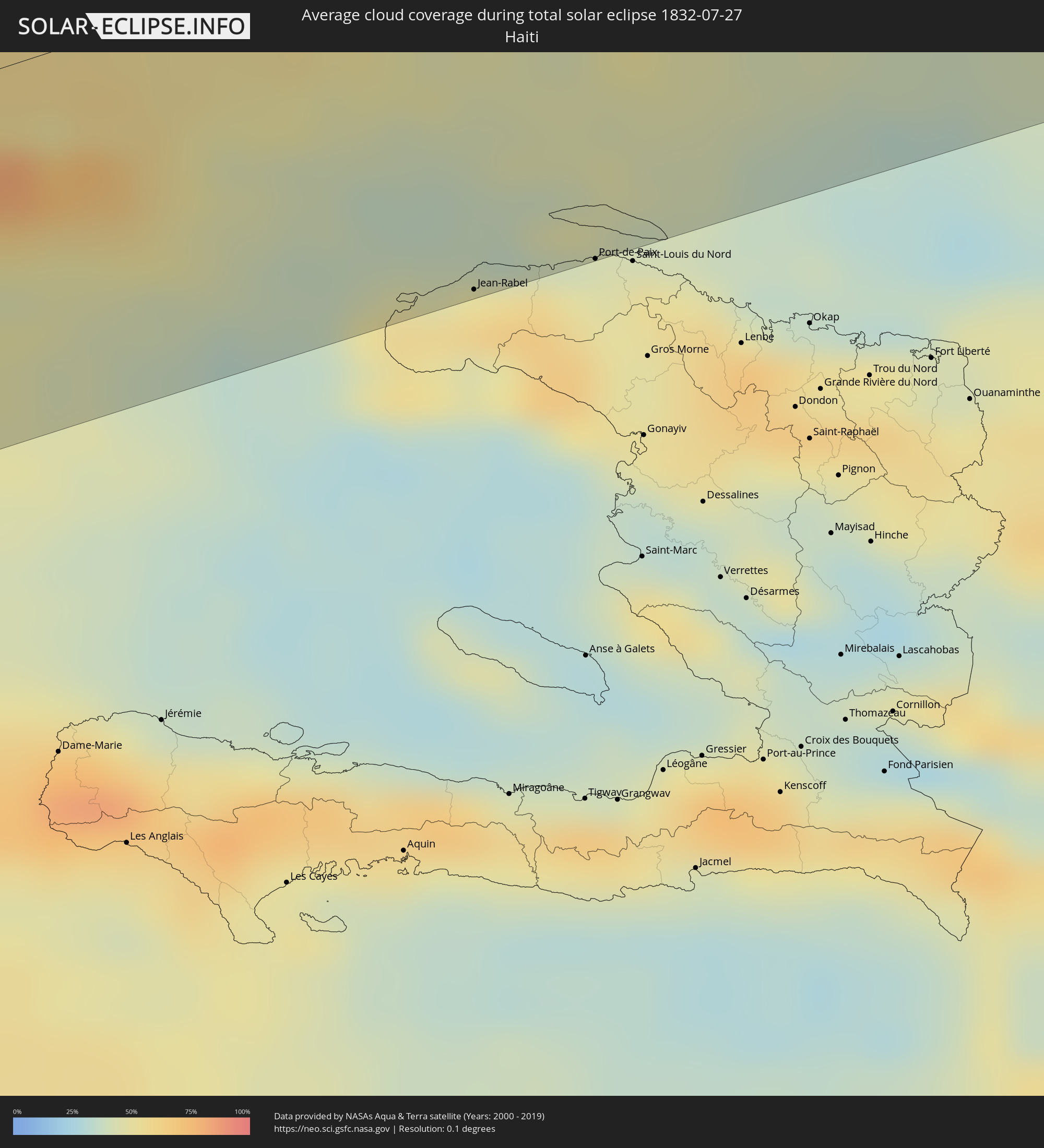 Haiti
Haiti
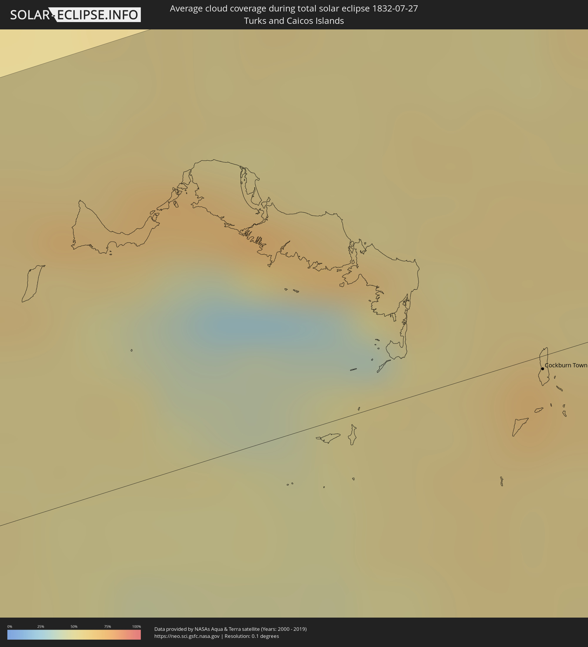 Turks- und Caicosinseln
 Mauretanien
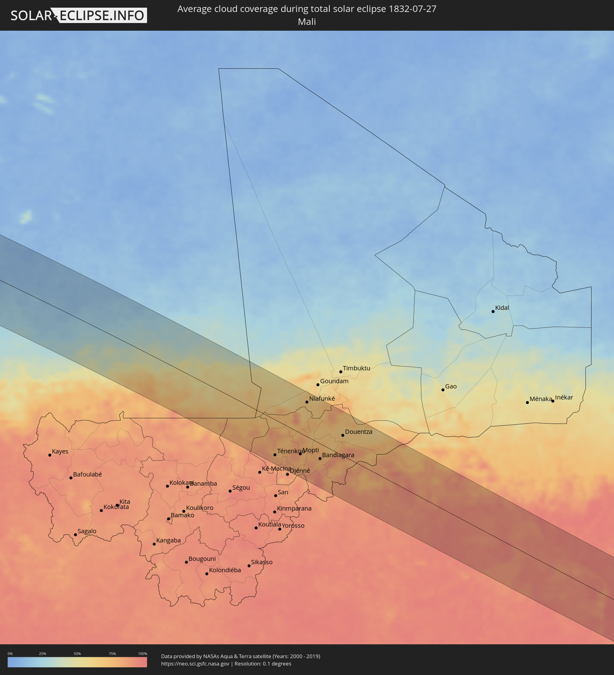 Mali
Mali
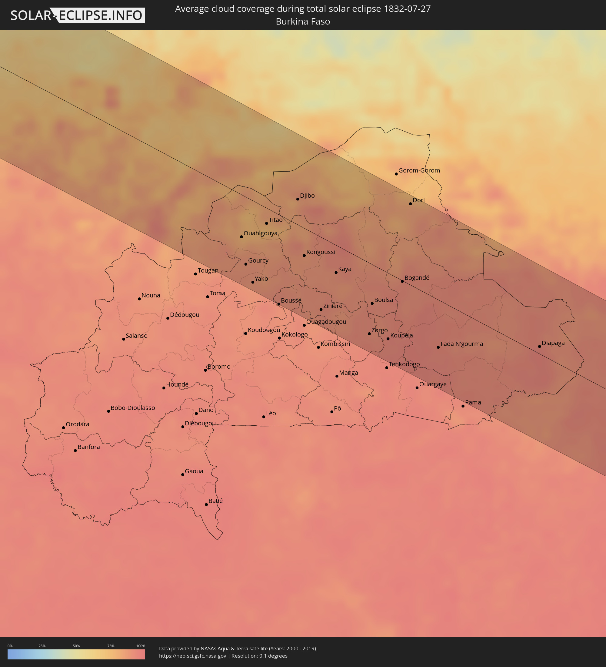 Burkina Faso
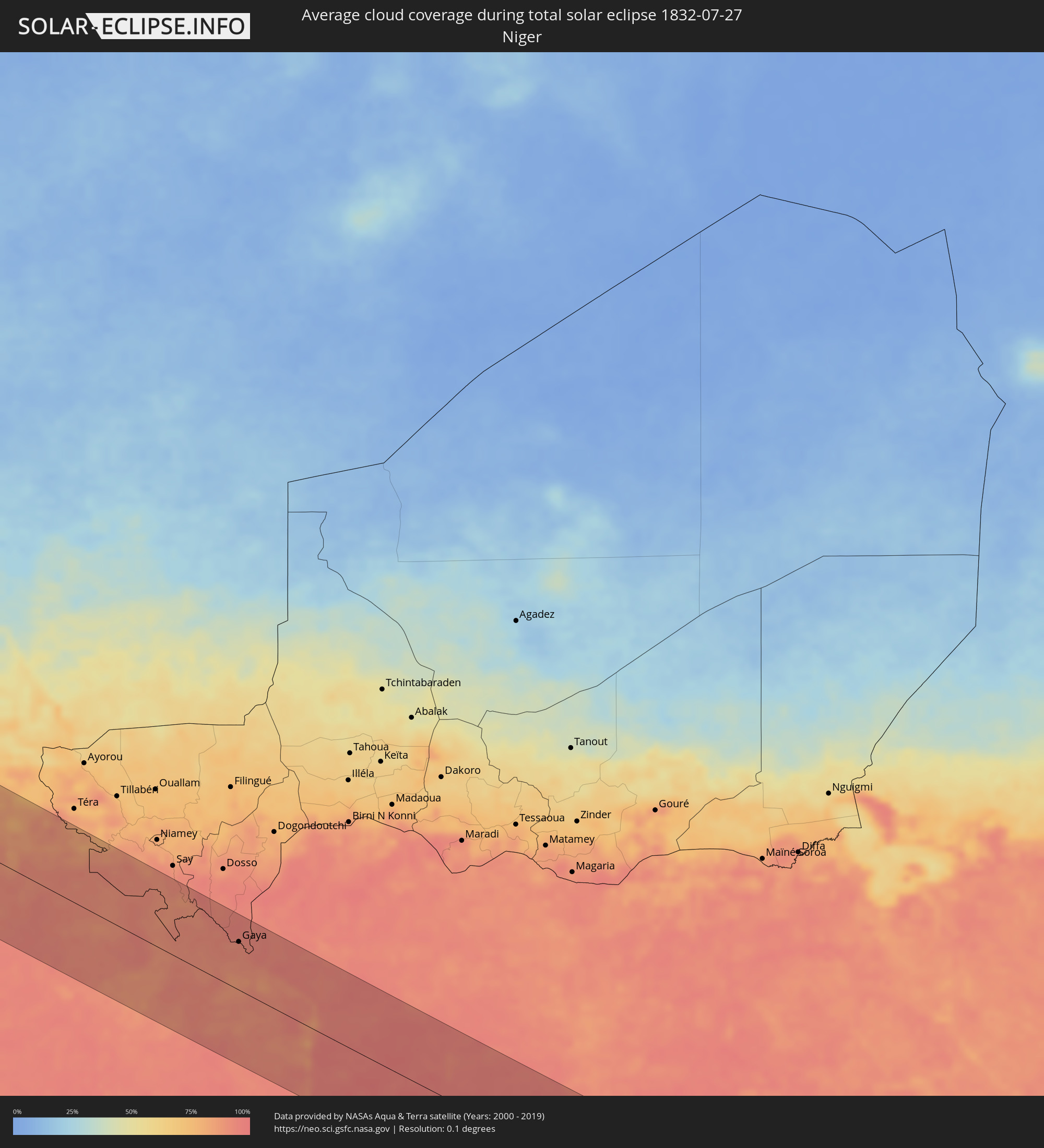 Niger
Niger
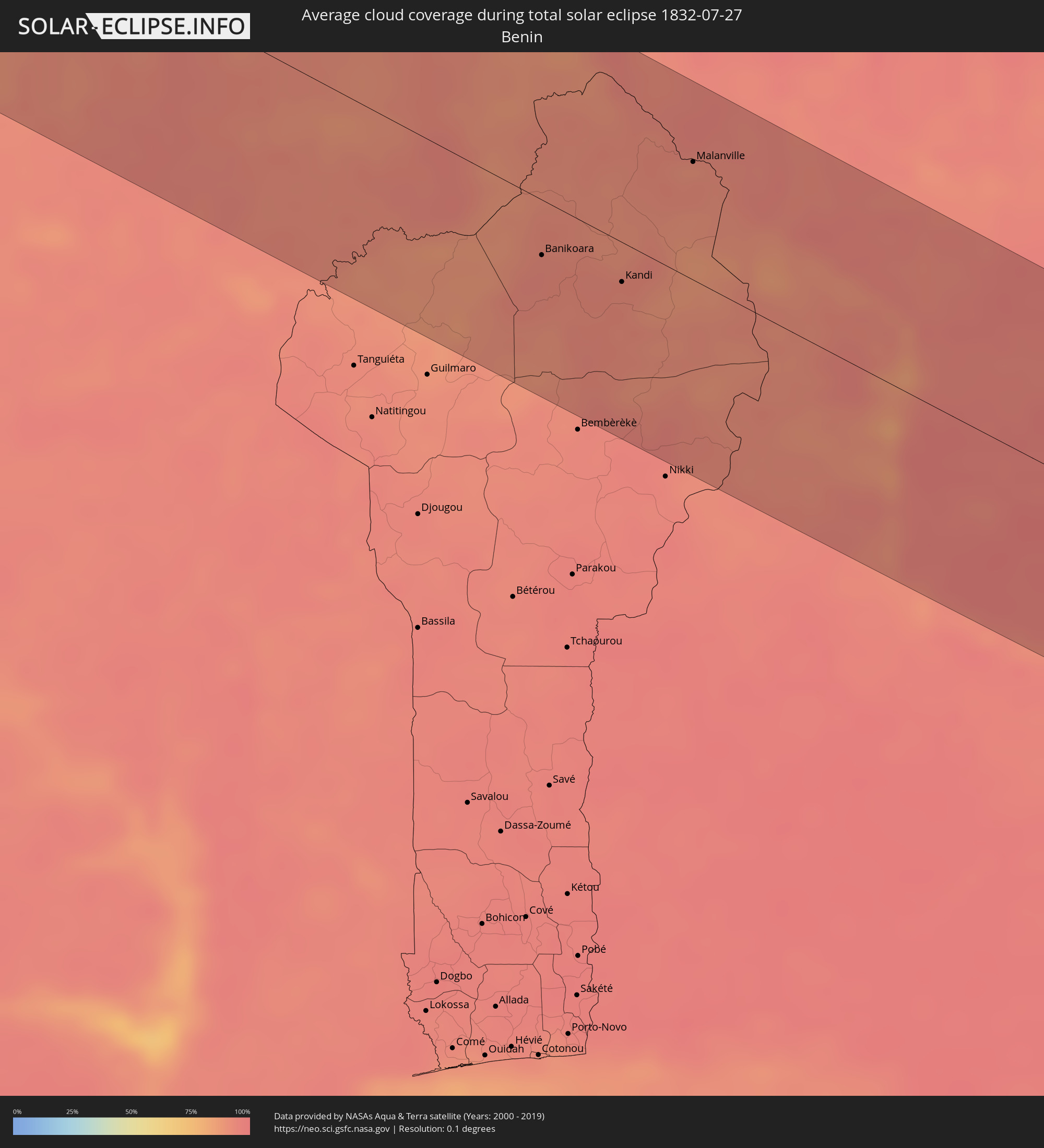 Benin
Benin
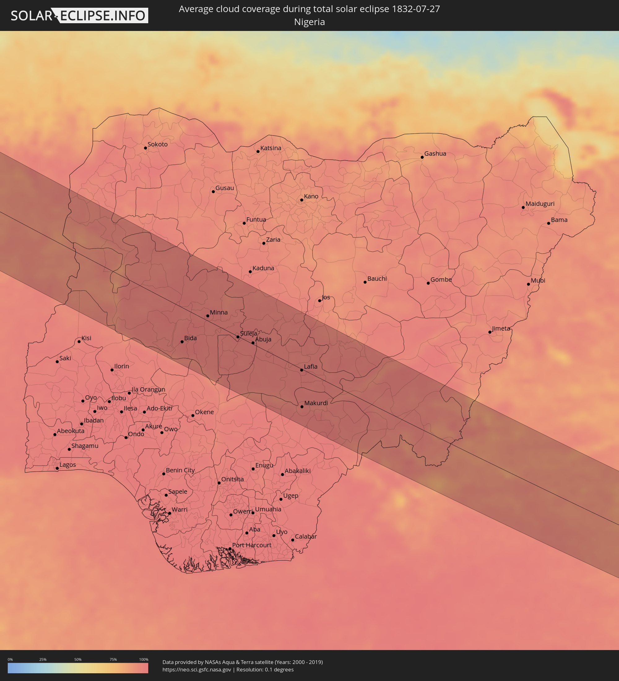 Nigeria
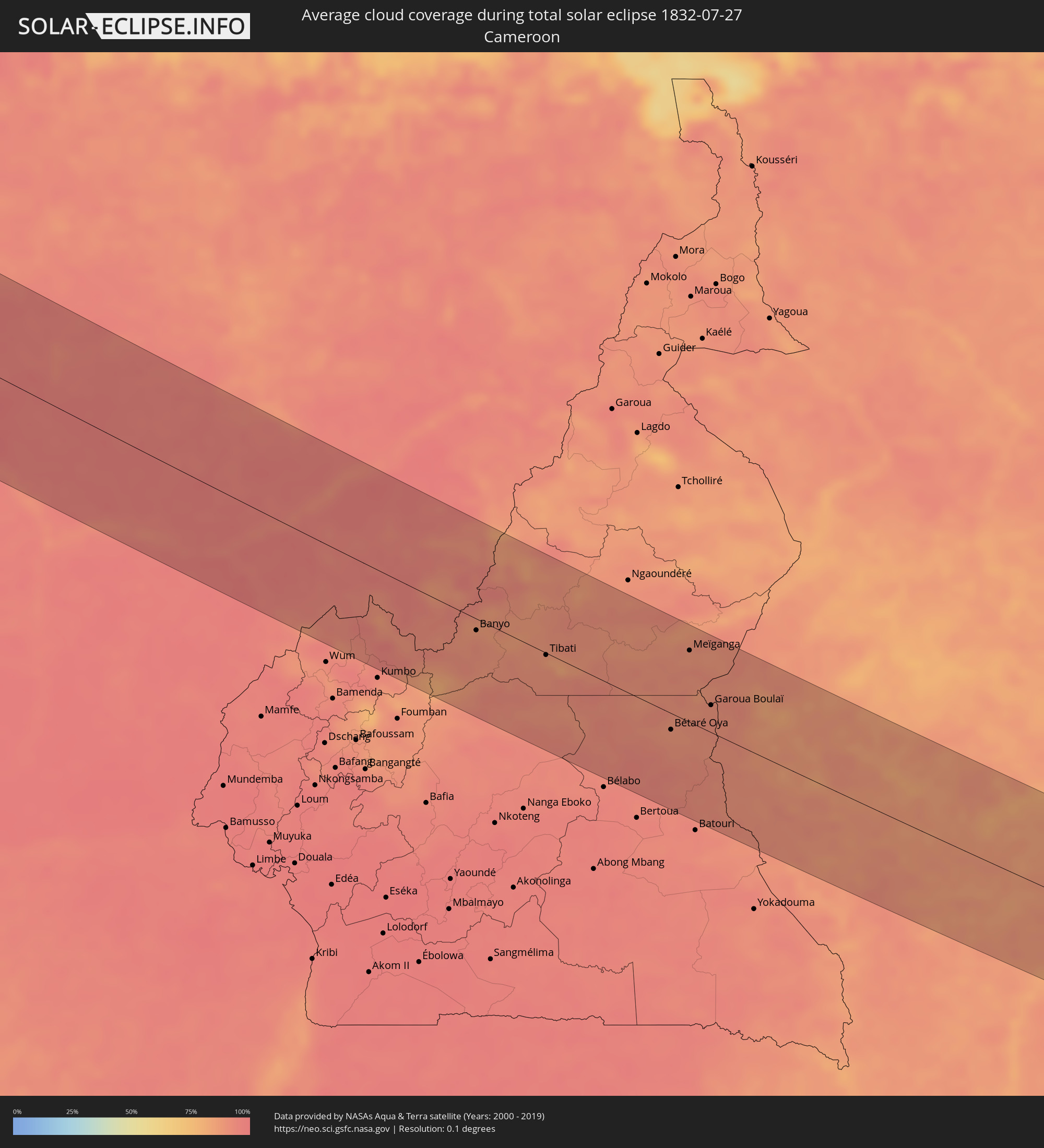 Kamerun
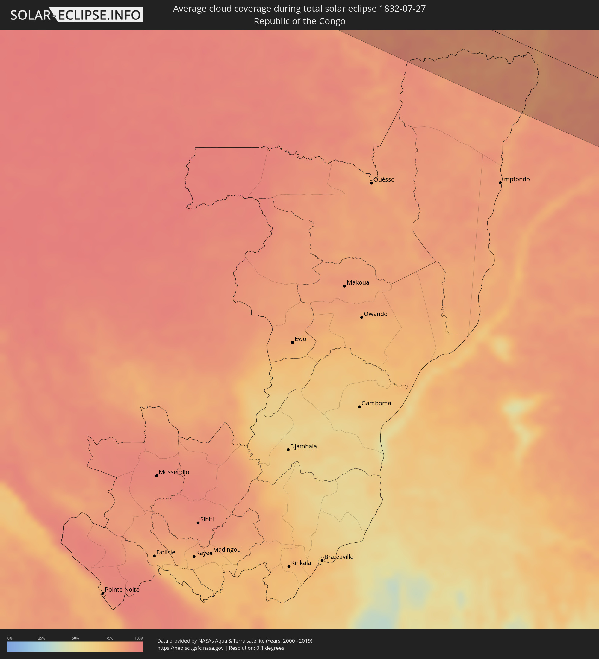 Republik Kongo
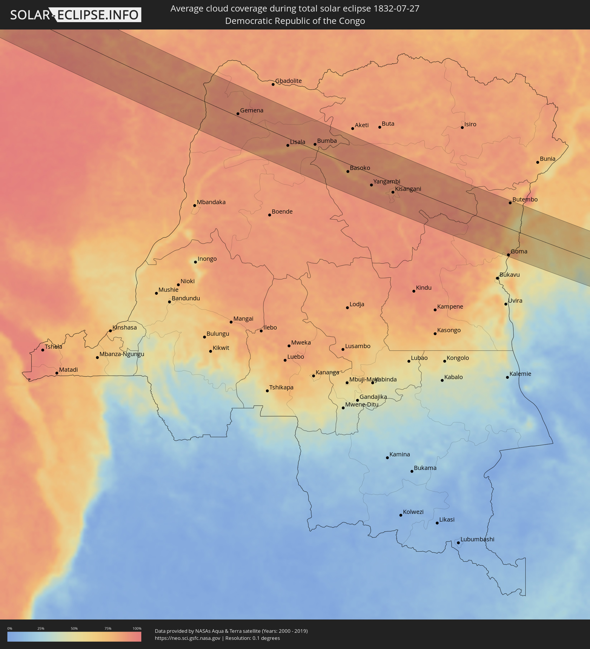 Demokratische Republik Kongo
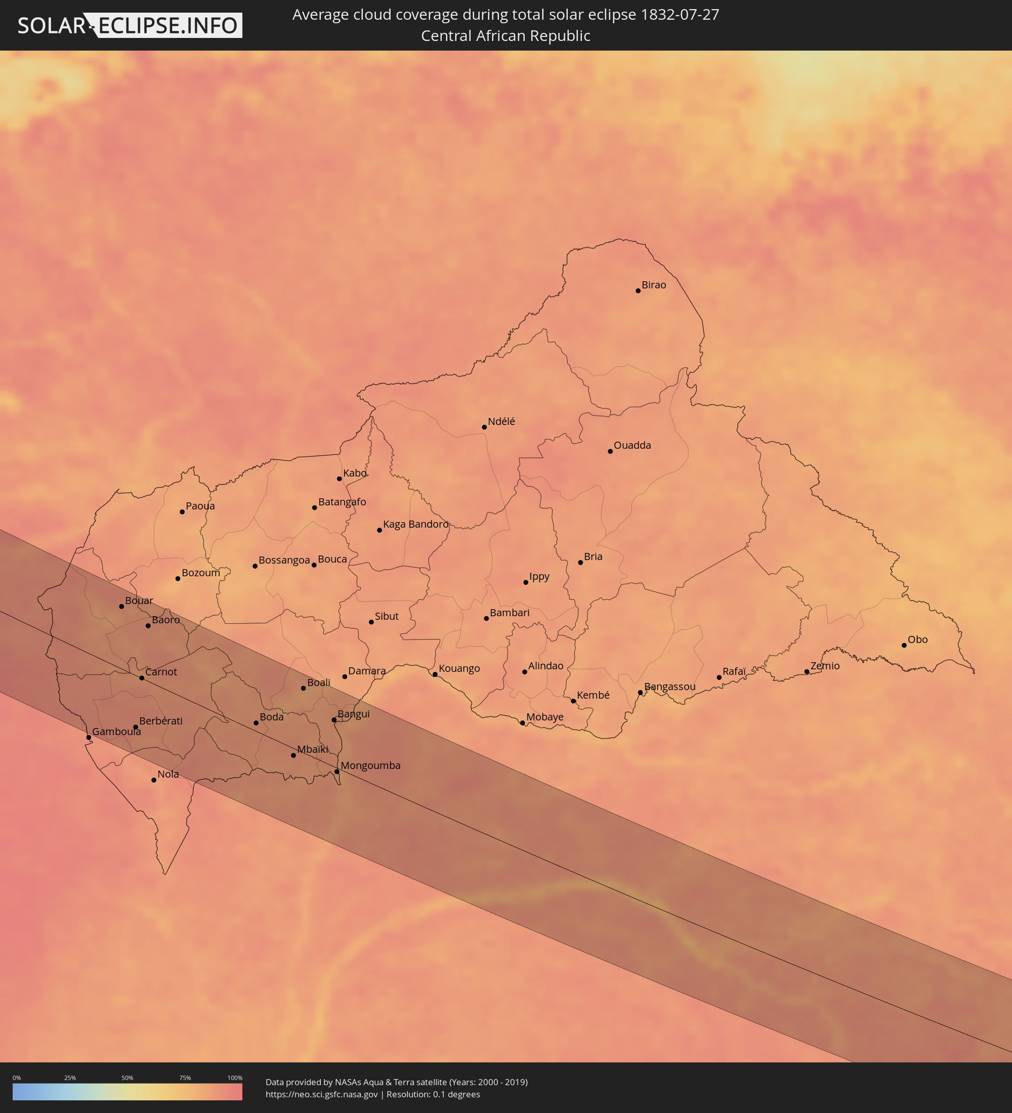 Zentralafrikanische Republik
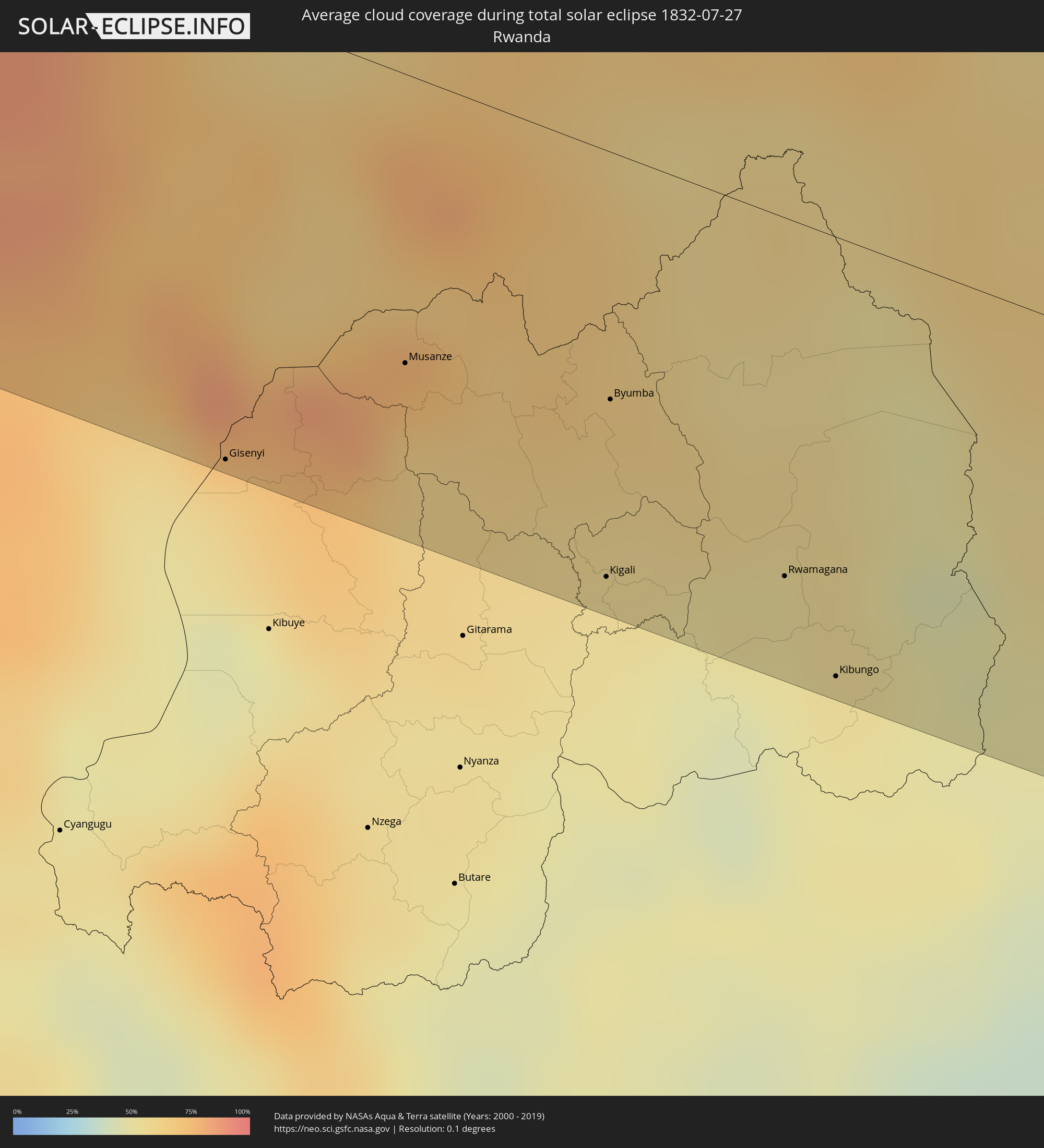 Ruanda
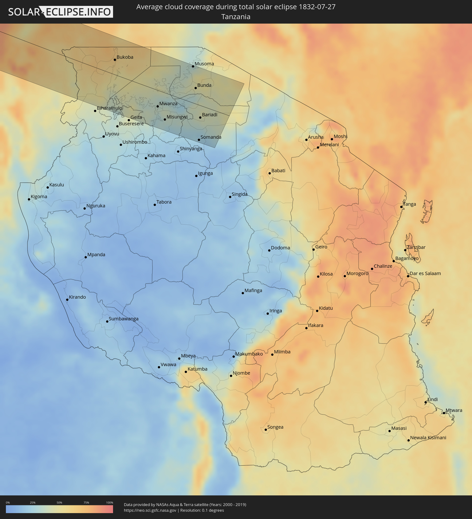 Tansania
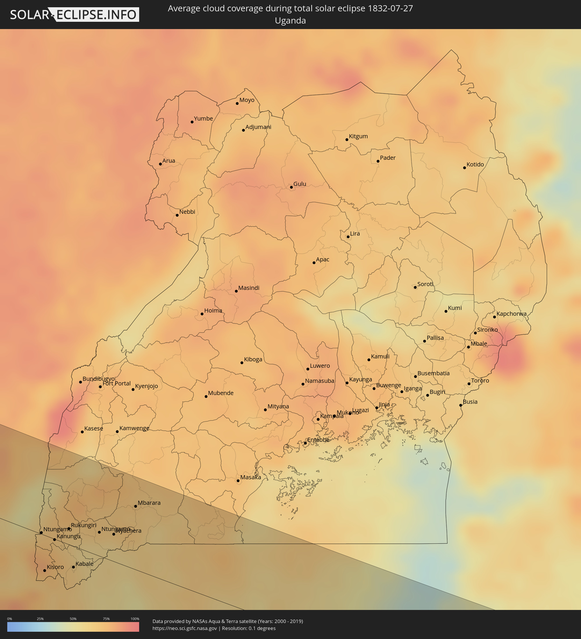 Uganda
Orte im Finsternispfad
Die nachfolgene Tabelle zeigt Städte und Orte mit mehr als 5.000 Einwohnern, die sich im Finsternispfad befinden. Städte mit mehr als 100.000 Einwohnern sind dick gekennzeichnet. Mit einem Klick auf den Ort öffnet sich eine Detailkarte die die Lage des jeweiligen Ortes zusammen mit dem Verlauf der zentralen Finsternis präsentiert.
| Ort | Typ | Dauer der Verfinsterung | Ortszeit bei maximaler Verfinsterung | Entfernung zur Zentrallinie | Ø Bewölkung |
|
Escuintla, Chiapas
|
total | - | 05:42:47 UTC-06:36 | 92 km | 65% |
|
Villa Comaltitlán, Chiapas
|
total | - | 05:42:44 UTC-06:36 | 78 km | 65% |
|
Huixtla, Chiapas
|
total | - | 05:42:42 UTC-06:36 | 66 km | 66% |
|
Puerto Madero, Chiapas
|
total | - | 05:42:30 UTC-06:36 | 21 km | 55% |
|
Huehuetán, Chiapas
|
total | - | 05:42:38 UTC-06:36 | 51 km | 68% |
|
Vida Mejor I, Chiapas
|
total | - | 05:42:34 UTC-06:36 | 32 km | 72% |
|
Tapachula, Chiapas
|
total | - | 05:42:35 UTC-06:36 | 34 km | 72% |
|
Motozintla, Chiapas
|
total | - | 05:42:49 UTC-06:36 | 82 km | 58% |
|
Brisas Barra de Suchiate, Chiapas
|
total | - | 06:16:57 UTC-06:02 | 6 km | 53% |
|
Tuxtla Chico, Chiapas
|
total | - | 05:42:36 UTC-06:36 | 34 km | 67% |
|
Quetzaltenango, Quetzaltenango
|
total | - | 06:17:07 UTC-06:02 | 0 km | 79% |
|
Huehuetenango, Huehuetenango
|
total | - | 06:17:21 UTC-06:02 | 49 km | 54% |
|
Totonicapán, Totonicapán
|
total | - | 06:17:10 UTC-06:02 | 2 km | 65% |
|
Chichicastenango, Quiché
|
total | - | 06:17:11 UTC-06:02 | 5 km | 71% |
|
Santa Lucía Cotzumalguapa, Escuintla
|
total | - | 06:16:55 UTC-06:02 | 71 km | 69% |
|
Chimaltenango, Chimaltenango
|
total | - | 06:17:05 UTC-06:02 | 44 km | 64% |
|
Escuintla, Escuintla
|
total | - | 06:16:55 UTC-06:02 | 83 km | 68% |
|
San Juan Sacatepéquez, Guatemala
|
total | - | 06:17:07 UTC-06:02 | 44 km | 69% |
|
Petapa, Guatemala
|
total | - | 06:17:02 UTC-06:02 | 70 km | 66% |
|
Guatemala City, Guatemala
|
total | - | 06:17:06 UTC-06:02 | 57 km | 66% |
|
Punta Gorda, Toledo
|
total | - | 06:27:17 UTC-05:52 | 33 km | 71% |
|
La Entrada, Copán
|
total | - | 06:30:42 UTC-05:48 | 79 km | 80% |
|
Dangriga, Stann Creek
|
total | - | 06:27:50 UTC-05:52 | 104 km | 70% |
|
Cofradía, Cortés
|
total | - | 06:30:58 UTC-05:48 | 64 km | 69% |
|
San Pedro Sula, Cortés
|
total | - | 06:31:02 UTC-05:48 | 57 km | 82% |
|
Villanueva, Cortés
|
total | - | 06:30:57 UTC-05:48 | 78 km | 71% |
|
Puerto Cortez, Cortés
|
total | - | 06:31:13 UTC-05:48 | 27 km | 74% |
|
El Progreso, Yoro
|
total | - | 06:31:01 UTC-05:48 | 76 km | 80% |
|
Morazán, Yoro
|
total | - | 06:31:01 UTC-05:48 | 92 km | 77% |
|
Tela, Atlántida
|
total | - | 06:31:16 UTC-05:48 | 49 km | 63% |
|
La Ceiba, Atlántida
|
total | - | 06:31:24 UTC-05:48 | 76 km | 68% |
|
Trujillo, Colón
|
total | - | 06:31:41 UTC-05:48 | 89 km | 72% |
|
George Town, George Town
|
total | - | 07:04:26 UTC-05:19 | 103 km | 70% |
|
Bodden Town, Bodden Town
|
total | - | 07:04:29 UTC-05:19 | 98 km | 65% |
|
North Side, North Side
|
total | - | 07:04:33 UTC-05:19 | 104 km | 65% |
|
East End, East End
|
total | - | 07:04:34 UTC-05:19 | 96 km | 63% |
|
Little Cayman, Sister Island
|
total | - | 07:05:15 UTC-05:19 | 99 km | 64% |
|
Lucea, Hanover
|
total | - | 07:17:57 UTC-05:07 | 95 km | 60% |
|
Montego Bay, St. James
|
total | - | 07:18:06 UTC-05:07 | 101 km | 61% |
|
Falmouth, Trelawny
|
total | - | 07:18:16 UTC-05:07 | 108 km | 57% |
|
Manzanillo, Granma
|
total | - | 06:57:20 UTC-05:29 | 70 km | 43% |
|
Bayamo, Granma
|
total | - | 06:57:40 UTC-05:29 | 57 km | 48% |
|
Holguín, Holguín
|
total | - | 06:58:15 UTC-05:29 | 99 km | 62% |
|
Contramaestre, Santiago de Cuba
|
total | - | 06:57:52 UTC-05:29 | 36 km | 50% |
|
Palma Soriano, Santiago de Cuba
|
total | - | 06:57:58 UTC-05:29 | 18 km | 56% |
|
San Luis, Santiago de Cuba
|
total | - | 06:58:03 UTC-05:29 | 11 km | 59% |
|
Santiago de Cuba, Santiago de Cuba
|
total | - | 06:57:58 UTC-05:29 | 7 km | 56% |
|
Banes, Holguín
|
total | - | 06:58:40 UTC-05:29 | 89 km | 51% |
|
Guantánamo, Guantánamo
|
total | - | 06:58:28 UTC-05:29 | 14 km | 61% |
|
Moa, Holguín
|
total | - | 06:58:59 UTC-05:29 | 32 km | 52% |
|
Matthew Town, Inagua
|
total | - | 07:20:14 UTC-05:09 | 21 km | 51% |
|
Jean-Rabel, Nord-Ouest
|
total | - | 07:40:23 UTC-04:49 | 110 km | 49% |
|
Port-de-Paix, Nord-Ouest
|
total | - | 07:40:44 UTC-04:49 | 112 km | 46% |
|
Cockburn Town
|
total | - | 07:25:02 UTC-05:07 | 3 km | 61% |
|
Nouâdhibou, Dakhlet Nouadhibou
|
total | - | 14:15:53 UTC-00:16 | 14 km | 66% |
|
Akjoujt, Inchiri
|
total | - | 14:23:20 UTC-00:16 | 22 km | 15% |
|
Atar, Adrar
|
total | - | 14:25:16 UTC-00:16 | 115 km | 15% |
|
Tidjikja, Tagant
|
total | - | 14:31:06 UTC-00:16 | 8 km | 20% |
|
Aioun, Hodh El Gharbi
|
total | - | 14:37:06 UTC-00:16 | 111 km | 53% |
|
Néma, Hodh ech Chargui
|
total | - | 14:41:33 UTC-00:16 | 1 km | 54% |
|
Ténenkou, Mopti
|
total | - | 14:48:15 UTC-00:16 | 97 km | 82% |
|
Mopti, Mopti
|
total | - | 14:49:25 UTC-00:16 | 58 km | 82% |
|
Niafunké, Tombouctou
|
total | - | 14:47:55 UTC-00:16 | 94 km | 67% |
|
Bandiagara, Mopti
|
total | - | 14:50:29 UTC-00:16 | 42 km | 77% |
|
Douentza, Mopti
|
total | - | 14:50:42 UTC-00:16 | 56 km | 76% |
|
Ouahigouya, Nord
|
total | - | 14:53:13 UTC-00:16 | 57 km | 79% |
|
Yako, Nord
|
total | - | 14:54:12 UTC-00:16 | 110 km | 87% |
|
Djibo, Sahel
|
total | - | 14:53:46 UTC-00:16 | 34 km | 86% |
|
Kongoussi, Centre-Nord
|
total | - | 14:54:49 UTC-00:16 | 37 km | 87% |
|
Kaya, Centre-Nord
|
total | - | 14:55:44 UTC-00:16 | 37 km | 89% |
|
Zorgo, Plateau-Central
|
total | - | 14:57:23 UTC-00:16 | 96 km | 93% |
|
Koupéla, Centre-Est
|
total | - | 14:57:49 UTC-00:16 | 89 km | 93% |
|
Dori, Sahel
|
total | - | 14:56:04 UTC-00:16 | 109 km | 84% |
|
Fada N'gourma, Est
|
total | - | 14:58:54 UTC-00:16 | 65 km | 93% |
|
Diapaga, Est
|
total | - | 15:00:43 UTC-00:16 | 10 km | 94% |
|
Banikoara, Alibori
|
total | - | 15:32:06 UTC+00:13 | 33 km | 94% |
|
Kandi, Alibori
|
total | - | 15:32:52 UTC+00:13 | 24 km | 93% |
|
Malanville, Atakora
|
total | - | 15:32:35 UTC+00:13 | 71 km | 92% |
|
Gaya, Dosso
|
total | - | 15:32:38 UTC+00:13 | 76 km | 92% |
|
Kontagora, Niger
|
total | - | 15:36:27 UTC+00:13 | 33 km | 96% |
|
Bida, Niger
|
total | - | 15:38:22 UTC+00:13 | 70 km | 98% |
|
Minna, Niger
|
total | - | 15:38:21 UTC+00:13 | 10 km | 97% |
|
Suleja, Niger
|
total | - | 15:39:24 UTC+00:13 | 2 km | 97% |
|
Kuje, Abuja Federal Capital Territory
|
total | - | 15:39:44 UTC+00:13 | 29 km | 97% |
|
Abuja, Abuja Federal Capital Territory
|
total | - | 15:39:49 UTC+00:13 | 2 km | 97% |
|
Keffi, Nassarawa
|
total | - | 15:40:22 UTC+00:13 | 0 km | 97% |
|
Lafia, Nassarawa
|
total | - | 15:41:17 UTC+00:13 | 3 km | 97% |
|
Makurdi, Benue
|
total | - | 15:42:00 UTC+00:13 | 78 km | 97% |
|
Wukari, Taraba
|
total | - | 15:42:55 UTC+00:13 | 2 km | 96% |
|
Bankim, Adamaoua
|
total | - | 15:45:50 UTC+00:13 | 96 km | 86% |
|
Banyo, Adamaoua
|
total | - | 15:45:29 UTC+00:13 | 13 km | 89% |
|
Yoko, Centre
|
total | - | 15:46:52 UTC+00:13 | 111 km | 94% |
|
Tibati, Adamaoua
|
total | - | 15:46:17 UTC+00:13 | 2 km | 87% |
|
Bétaré Oya, East
|
total | - | 15:47:56 UTC+00:13 | 19 km | 88% |
|
Meïganga, Adamaoua
|
total | - | 15:47:18 UTC+00:13 | 83 km | 88% |
|
Garoua Boulaï, East
|
total | - | 15:47:58 UTC+00:13 | 32 km | 90% |
|
Bouar, Nana-Mambéré
|
total | - | 15:48:31 UTC+00:13 | 86 km | 86% |
|
Berbérati, Mambéré-Kadéï
|
total | - | 15:49:56 UTC+00:13 | 73 km | 88% |
|
Carnot, Mambéré-Kadéï
|
total | - | 15:49:27 UTC+00:13 | 0 km | 88% |
|
Baoro, Nana-Mambéré
|
total | - | 15:48:56 UTC+00:13 | 77 km | 86% |
|
Boda, Lobaye
|
total | - | 15:50:42 UTC+00:13 | 11 km | 87% |
|
Mbaïki, Lobaye
|
total | - | 15:51:16 UTC+00:13 | 11 km | 87% |
|
Boali, Ombella-M'Poko
|
total | - | 15:50:38 UTC+00:13 | 90 km | 80% |
|
Bimbo, Ombella-M'Poko
|
total | - | 15:51:10 UTC+00:13 | 48 km | 85% |
|
Bangui, Bangui
|
total | - | 15:51:08 UTC+00:13 | 65 km | 84% |
|
Mongoumba, Lobaye
|
total | - | 15:51:41 UTC+00:13 | 6 km | 81% |
|
Libenge, Équateur
|
total | - | 15:51:41 UTC+00:13 | 3 km | 80% |
|
Gemena, Équateur
|
total | - | 15:52:24 UTC+00:13 | 8 km | 91% |
|
Businga, Équateur
|
total | - | 15:52:43 UTC+00:13 | 67 km | 90% |
|
Lisala, Équateur
|
total | - | 15:53:41 UTC+00:13 | 26 km | 81% |
|
Bumba, Équateur
|
total | - | 15:53:56 UTC+00:13 | 19 km | 79% |
|
Basoko, Orientale
|
total | - | 17:51:31 UTC+02:10 | 29 km | 78% |
|
Yangambi, Orientale
|
total | - | 17:51:57 UTC+02:10 | 42 km | 83% |
|
Kisangani, Orientale
|
total | - | 17:52:13 UTC+02:10 | 36 km | 88% |
|
Goma, Nord Kivu
|
total | - | 17:53:40 UTC+02:10 | 98 km | 55% |
|
Gisenyi, Western Province
|
total | - | 17:53:41 UTC+02:10 | 100 km | 63% |
|
Butembo, Nord Kivu
|
total | - | 17:52:48 UTC+02:10 | 94 km | 80% |
|
Musanze, Northern Province
|
total | - | 17:53:36 UTC+02:10 | 63 km | 66% |
|
Ntungamo, Western Region
|
total | - | 18:10:14 UTC+02:27 | 1 km | 76% |
|
Kisoro, Western Region
|
total | - | 18:10:26 UTC+02:27 | 39 km | 71% |
|
Kanungu, Western Region
|
total | - | 18:10:17 UTC+02:27 | 1 km | 74% |
|
Rukungiri, Western Region
|
total | - | 18:10:13 UTC+02:27 | 17 km | 65% |
|
Kabale, Western Region
|
total | - | 18:10:25 UTC+02:27 | 23 km | 66% |
|
Kigali, Kigali
|
total | - | 17:53:48 UTC+02:10 | 94 km | 53% |
|
Byumba, Northern Province
|
total | - | 17:53:38 UTC+02:10 | 54 km | 60% |
|
Ntungamo, Western Region
|
total | - | 18:10:14 UTC+02:27 | 26 km | 58% |
|
Nyachera, Western Region
|
total | - | 18:10:15 UTC+02:27 | 30 km | 58% |
|
Rwamagana, Eastern Province
|
total | - | 17:53:47 UTC+02:10 | 79 km | 53% |
|
Kibungo, Eastern Province
|
total | - | 17:53:53 UTC+02:10 | 97 km | 50% |
|
Bwizibwera, Western Region
|
total | - | 18:10:06 UTC+02:27 | 70 km | 69% |
|
Mbarara, Western Region
|
total | - | 18:10:06 UTC+02:27 | 70 km | 69% |
|
Byakabanda, Central Region
|
total | - | 18:10:09 UTC+02:27 | 85 km | 68% |
|
Chato, Geita
|
total | - | 18:10:58 UTC+02:27 | 99 km | 31% |
|
Bukoba, Kagera
|
total | - | 18:10:24 UTC+02:27 | 39 km | 60% |
|
Kasamwa, Geita
|
total | - | 18:11:00 UTC+02:27 | 96 km | 33% |
|
Mwanza, Mwanza
|
total | - | 18:10:50 UTC+02:27 | 44 km | 35% |
|
Misungwi, Mwanza
|
total | - | 18:10:57 UTC+02:27 | 72 km | 27% |
|
Musoma, Mara
|
total | - | 18:10:19 UTC+02:27 | 97 km | 39% |
|
Bunda, Mara
|
total | - | 18:10:33 UTC+02:27 | 42 km | 37% |
|
Somanda, Simiyu
|
total | - | 18:11:03 UTC+02:27 | 93 km | 18% |
|
Bariadi, Simiyu
|
total | - | 18:10:50 UTC+02:27 | 33 km | 39% |
|
Kisesa, Simiyu
|
total | - | 18:10:55 UTC+02:27 | 56 km | 31% |