Totale Sonnenfinsternis vom 15.03.1839
| Wochentag: | Freitag |
| Maximale Dauer der Verfinsterung: | 04m20s |
| Maximale Breite des Finsternispfades: | 172 km |
| Saroszyklus: | 127 |
| Bedeckungsgrad: | 100% |
| Magnitude: | 1.052 |
| Gamma: | -0.0558 |
Wo kann man die Sonnenfinsternis vom 15.03.1839 sehen?
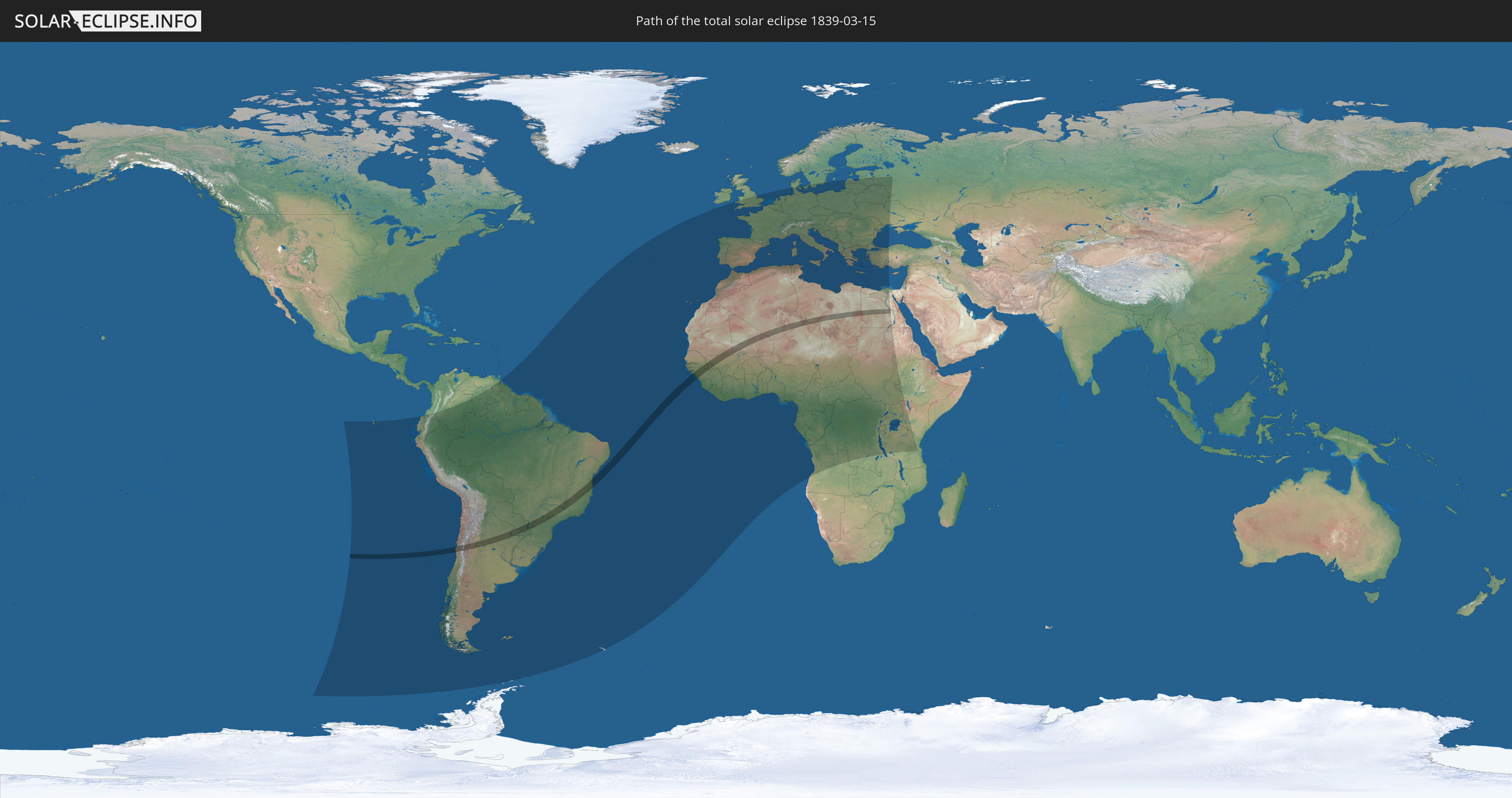
Die Sonnenfinsternis am 15.03.1839 kann man in 98 Ländern als partielle Sonnenfinsternis beobachten.
Der Finsternispfad verläuft durch 13 Länder. Nur in diesen Ländern ist sie als totale Sonnenfinsternis zu sehen.
In den folgenden Ländern ist die Sonnenfinsternis total zu sehen
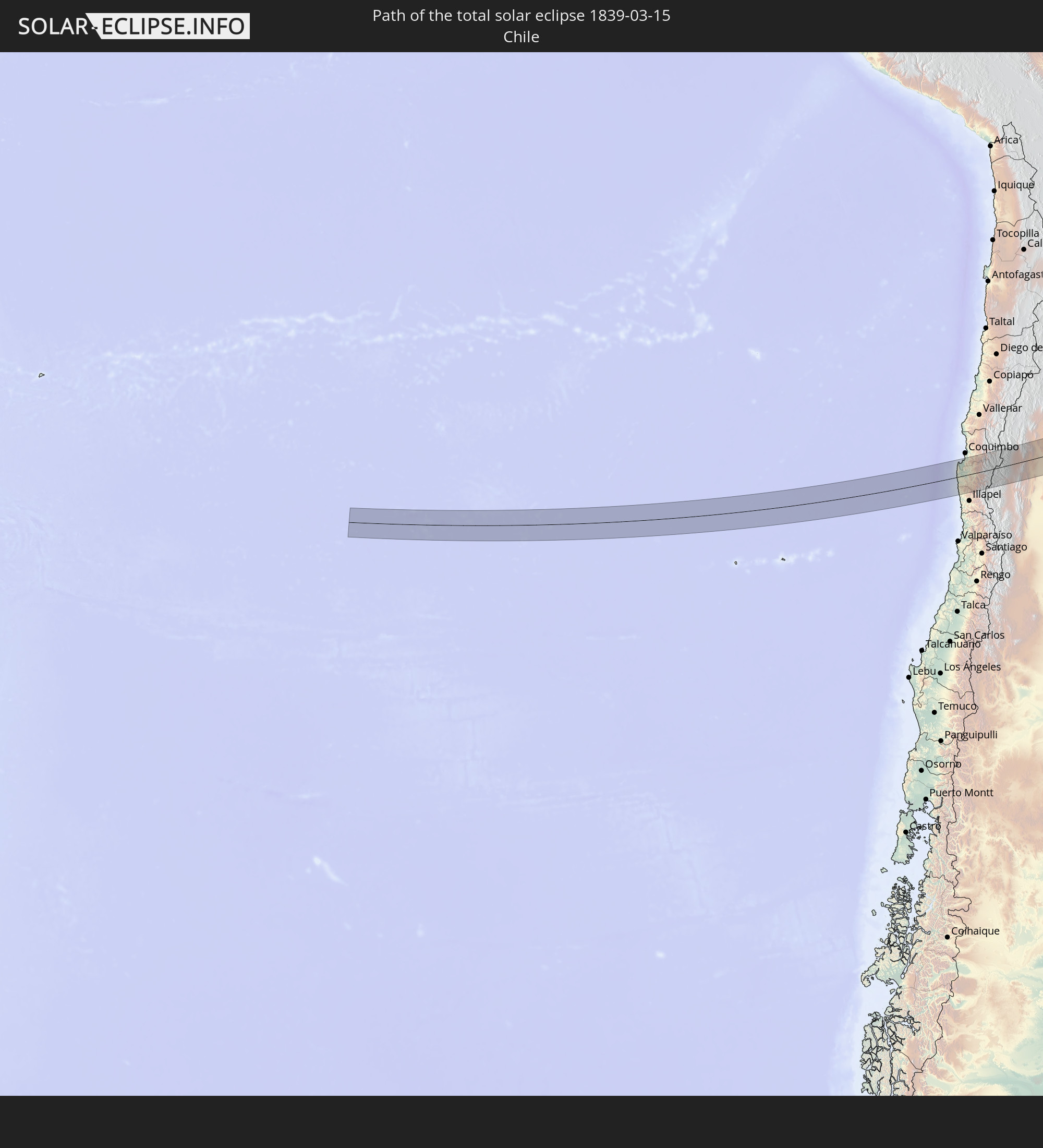 Chile
Chile
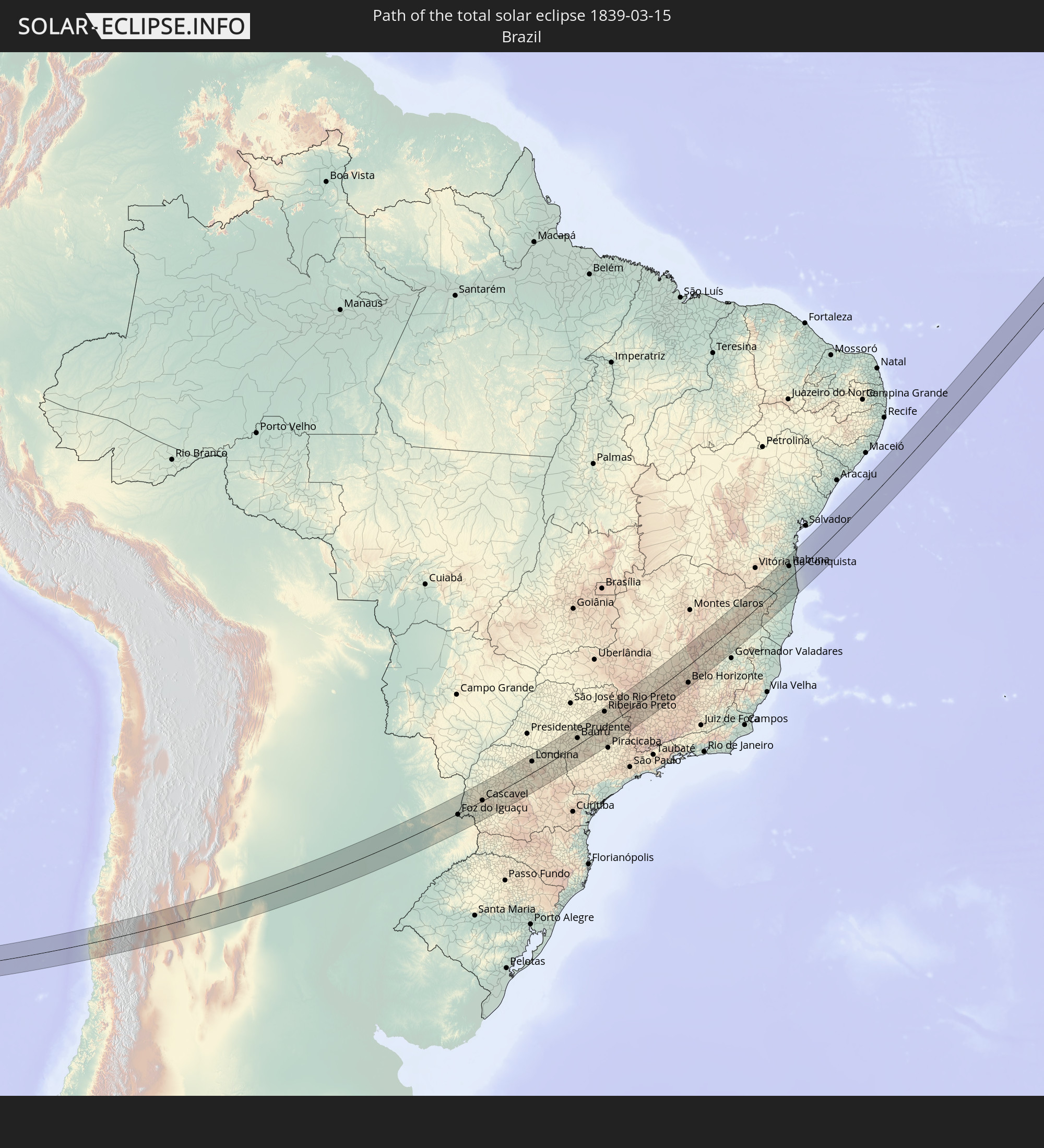 Brasilien
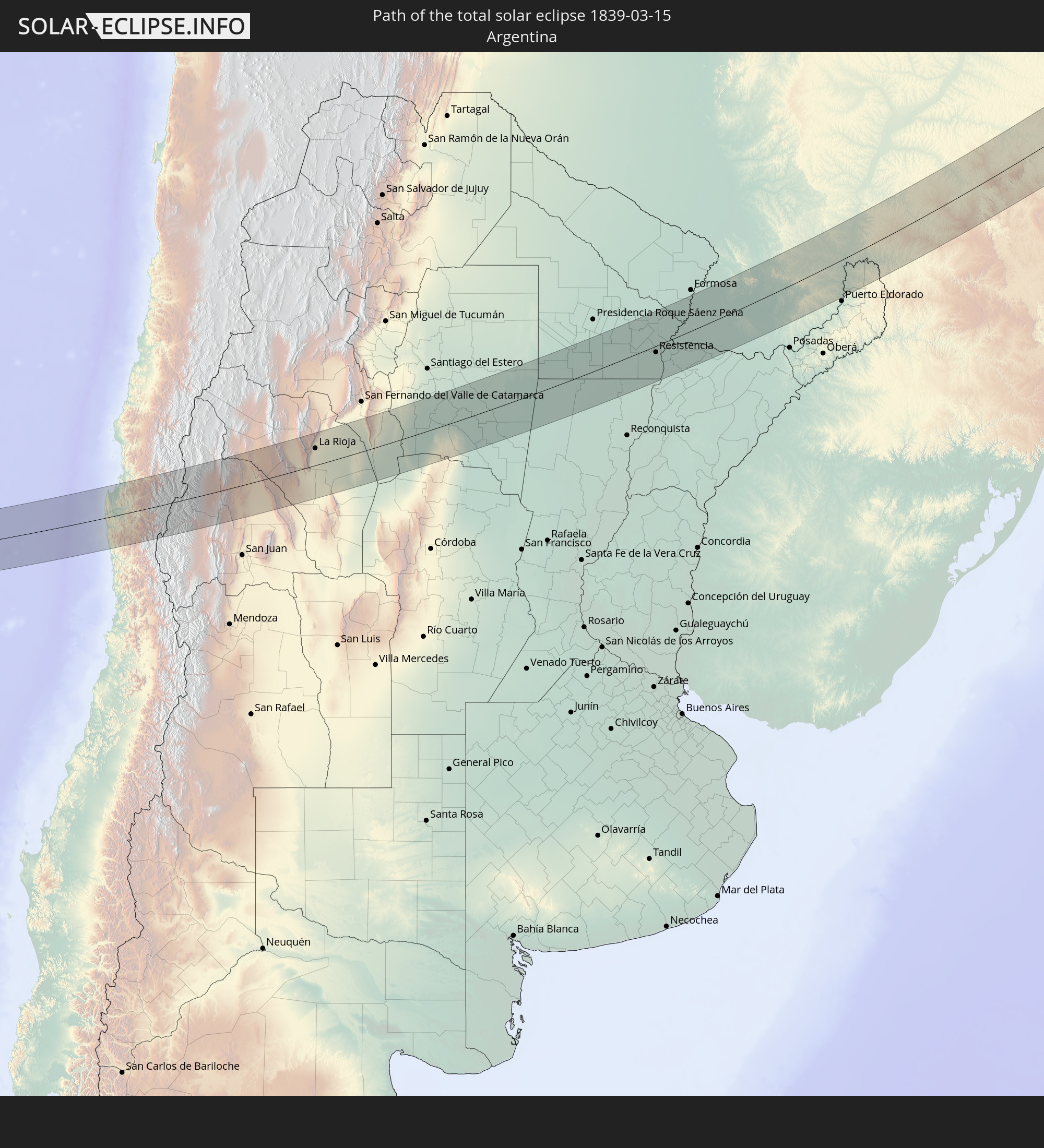 Argentinien
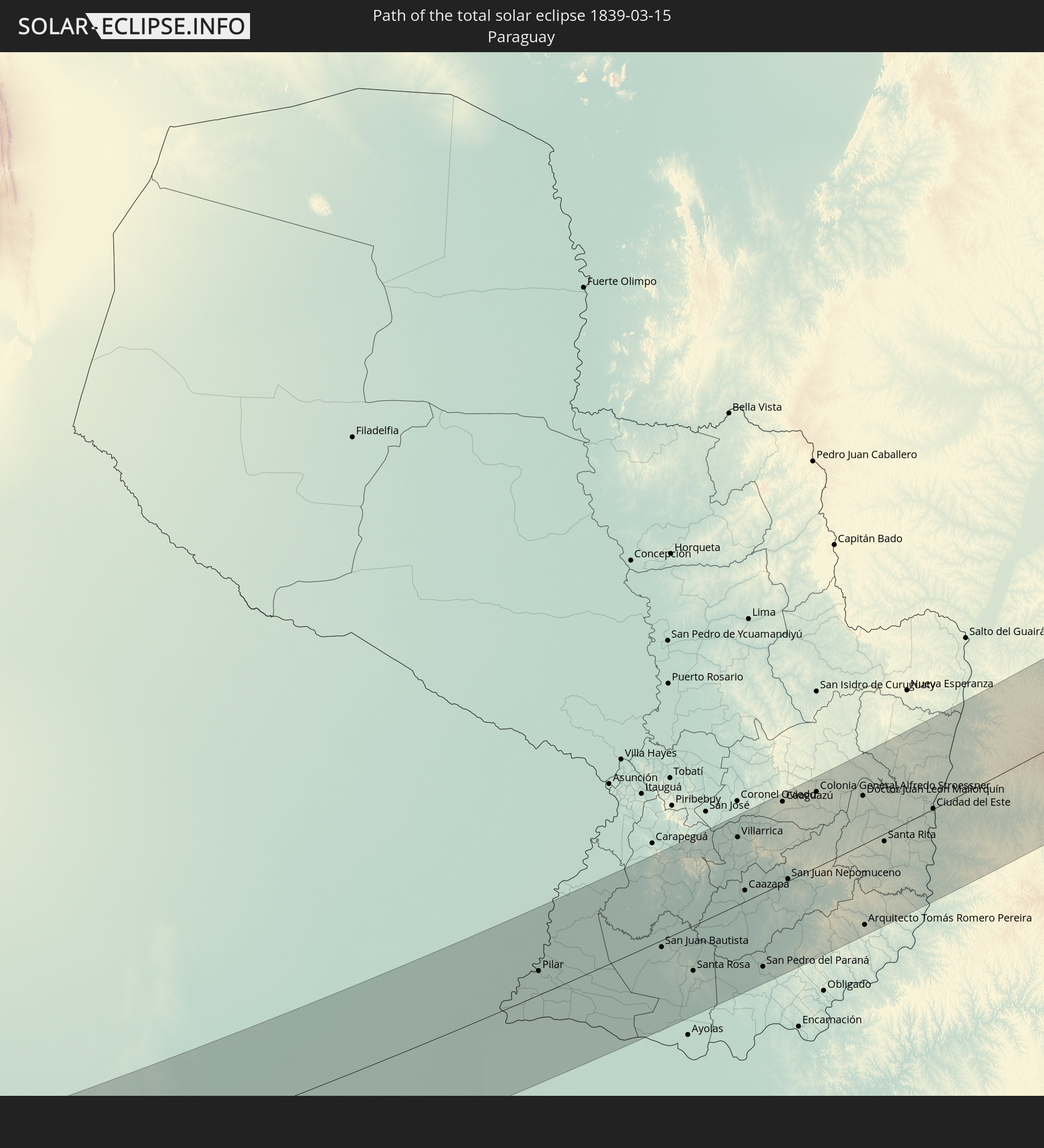 Paraguay
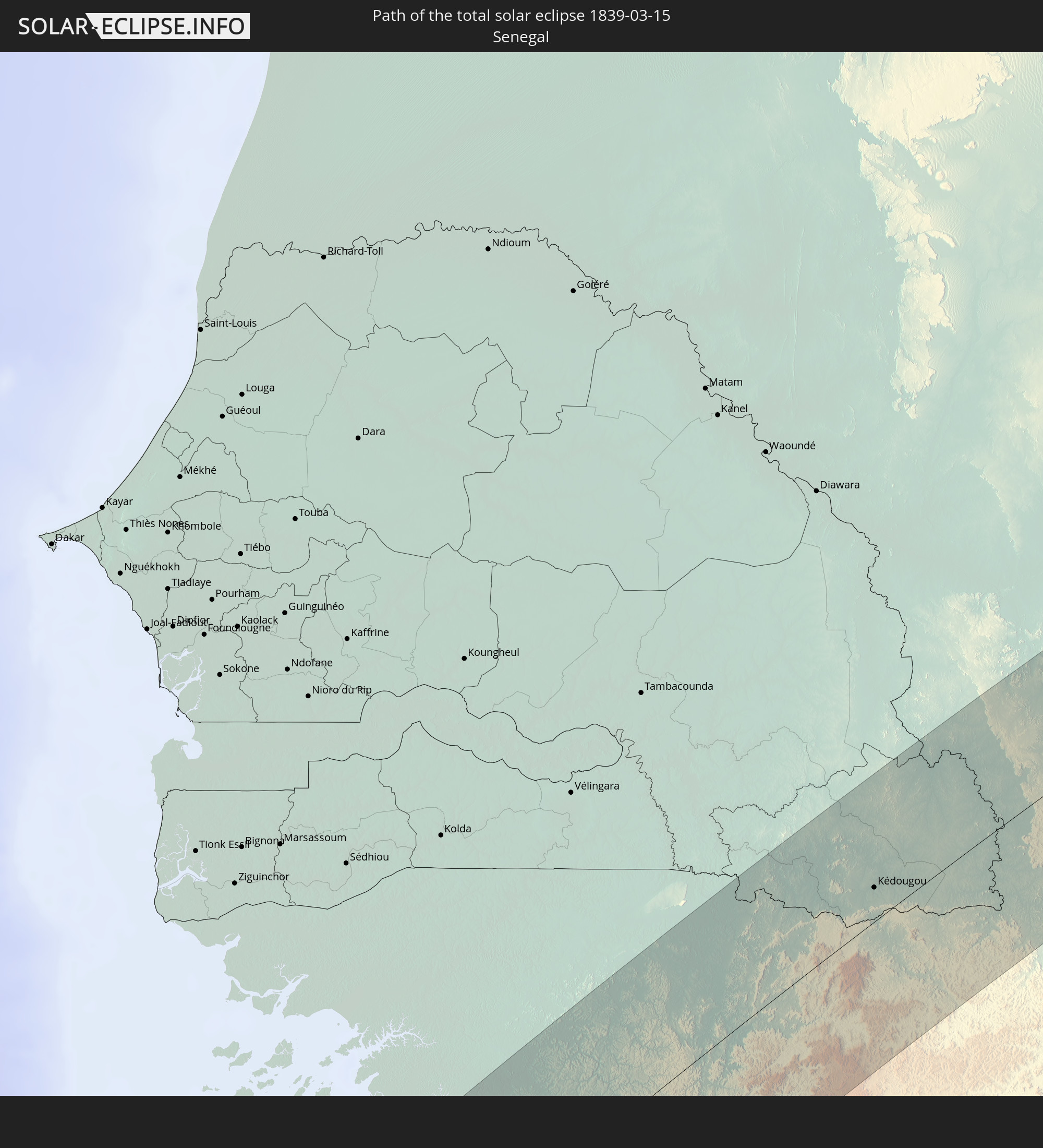 Senegal
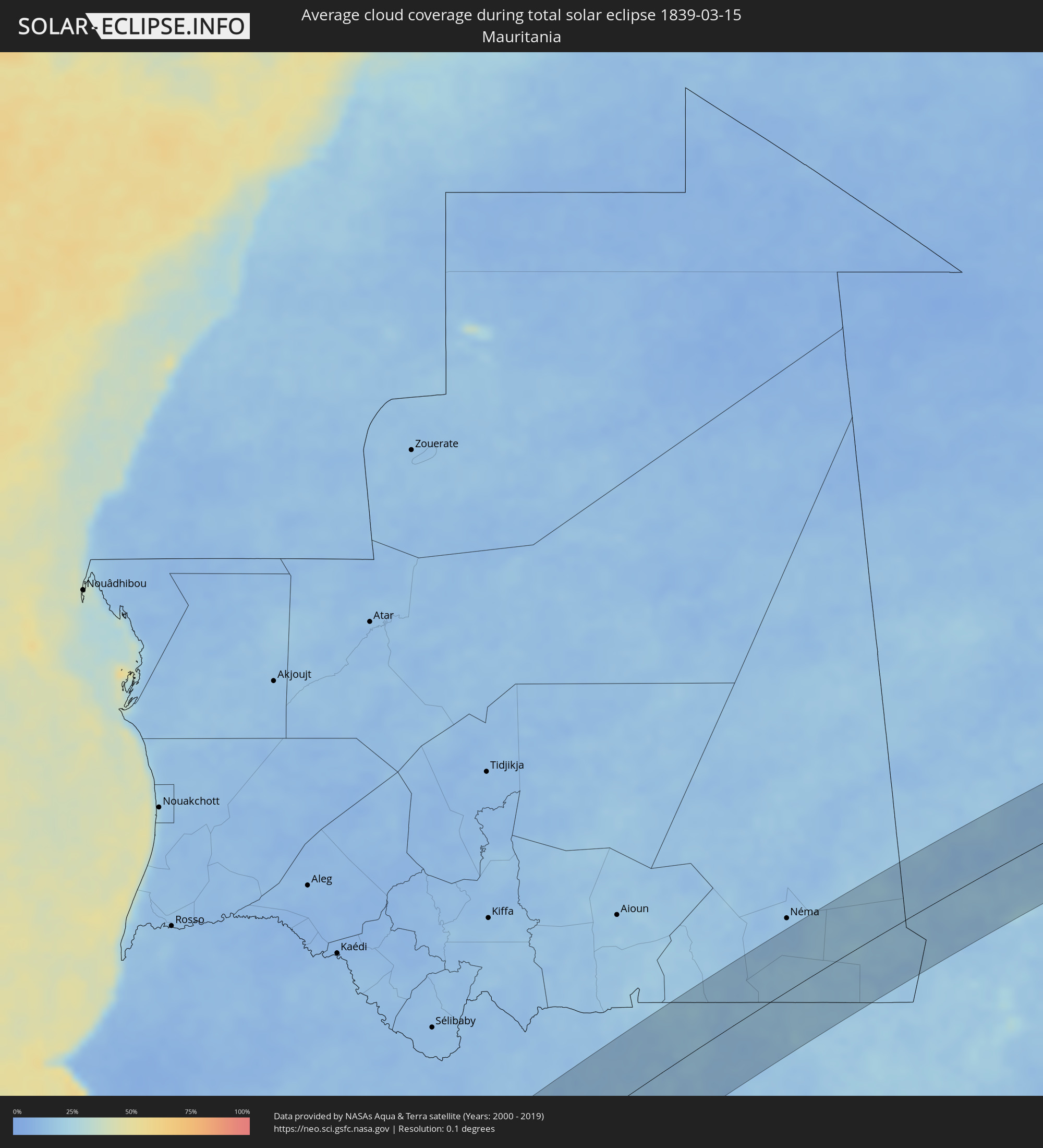
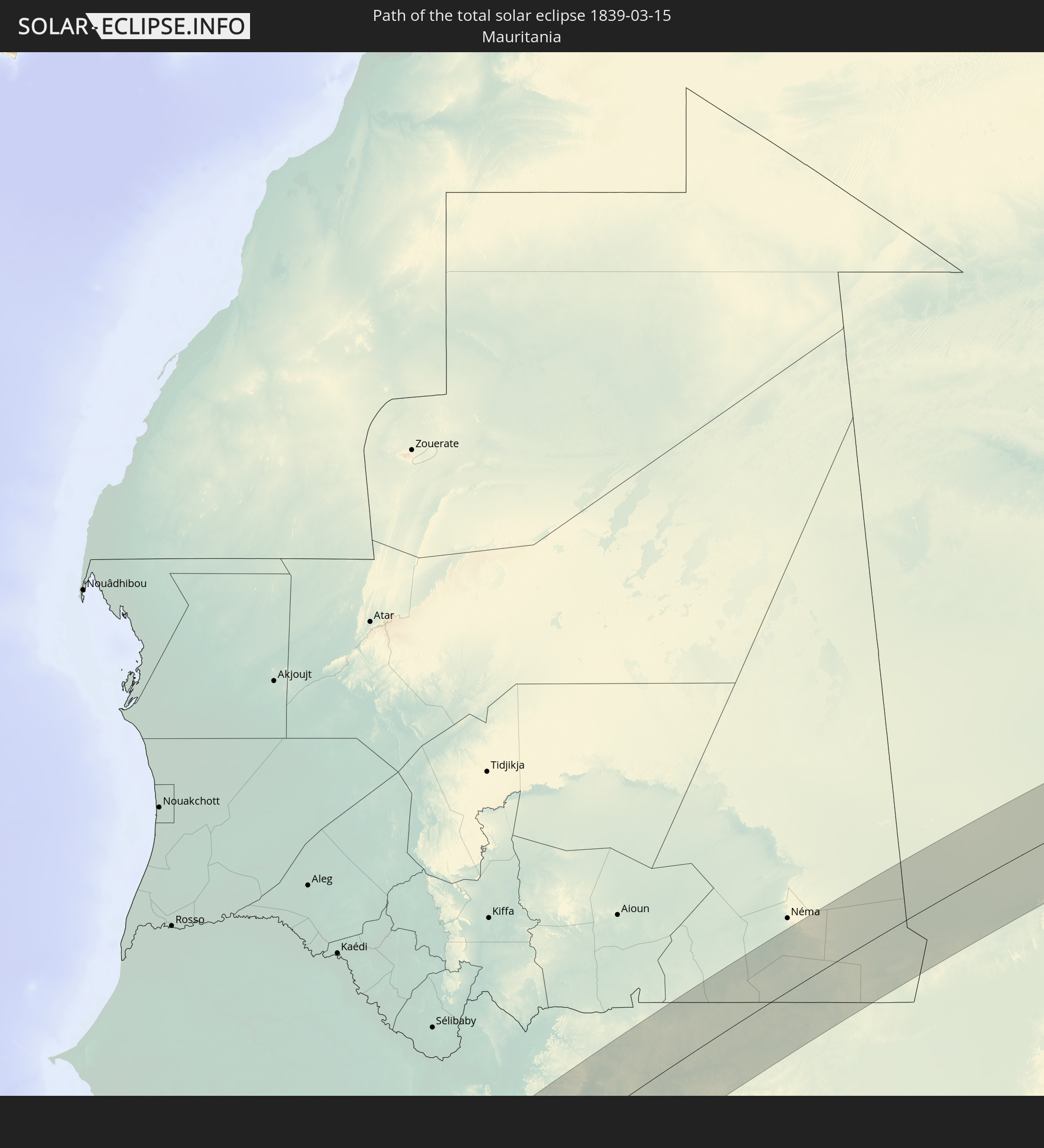 Mauretanien
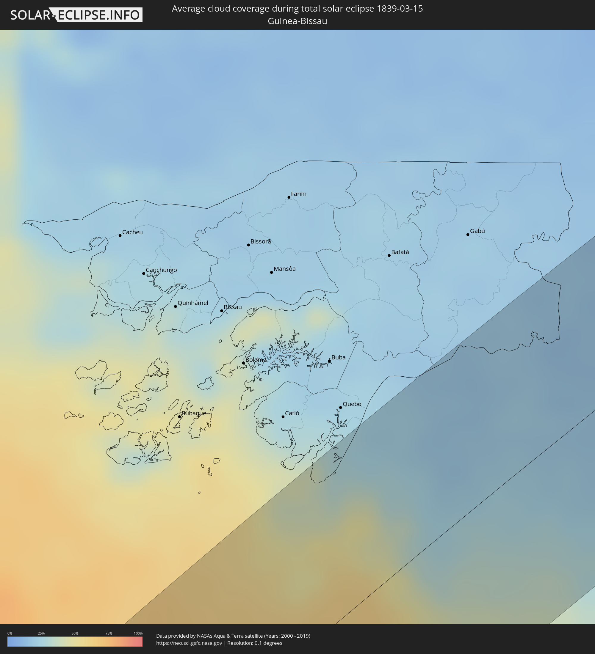
 Guinea-Bissau
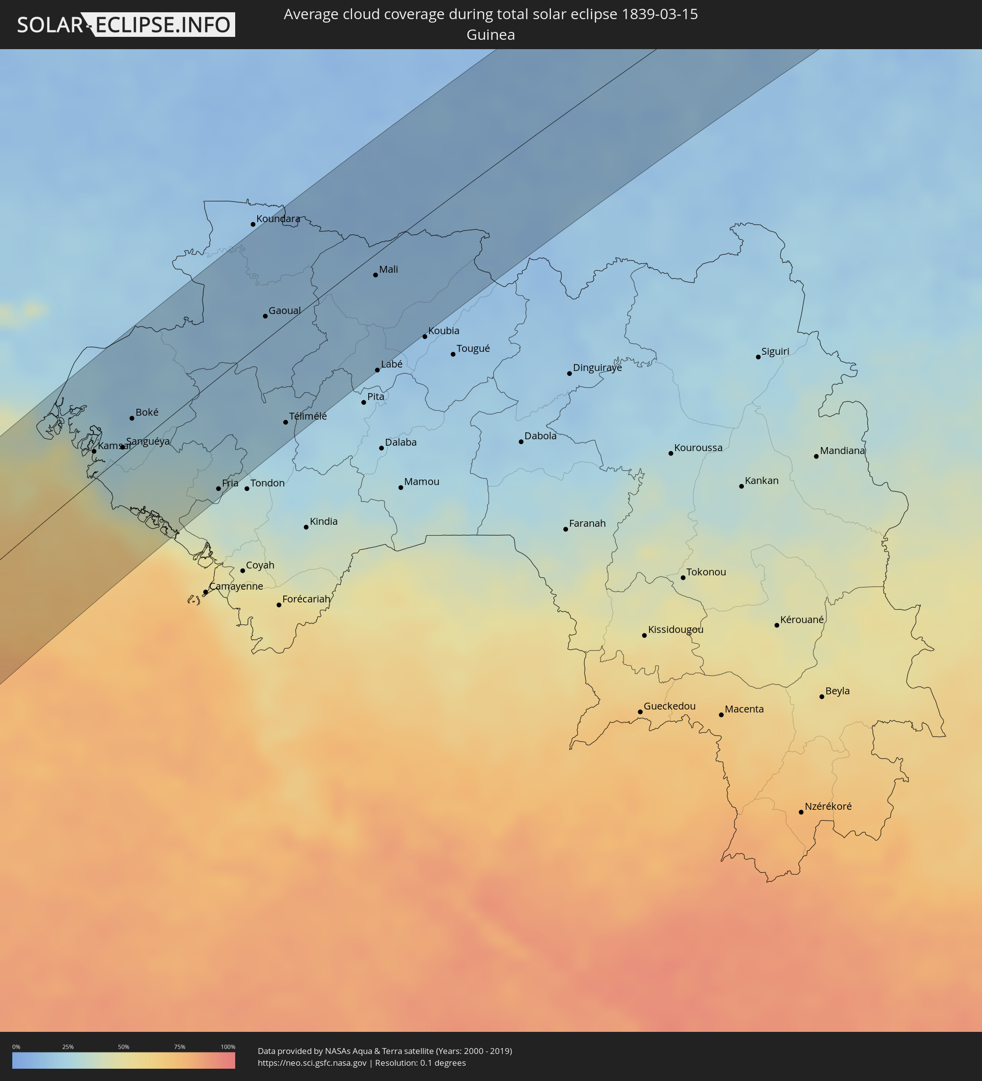
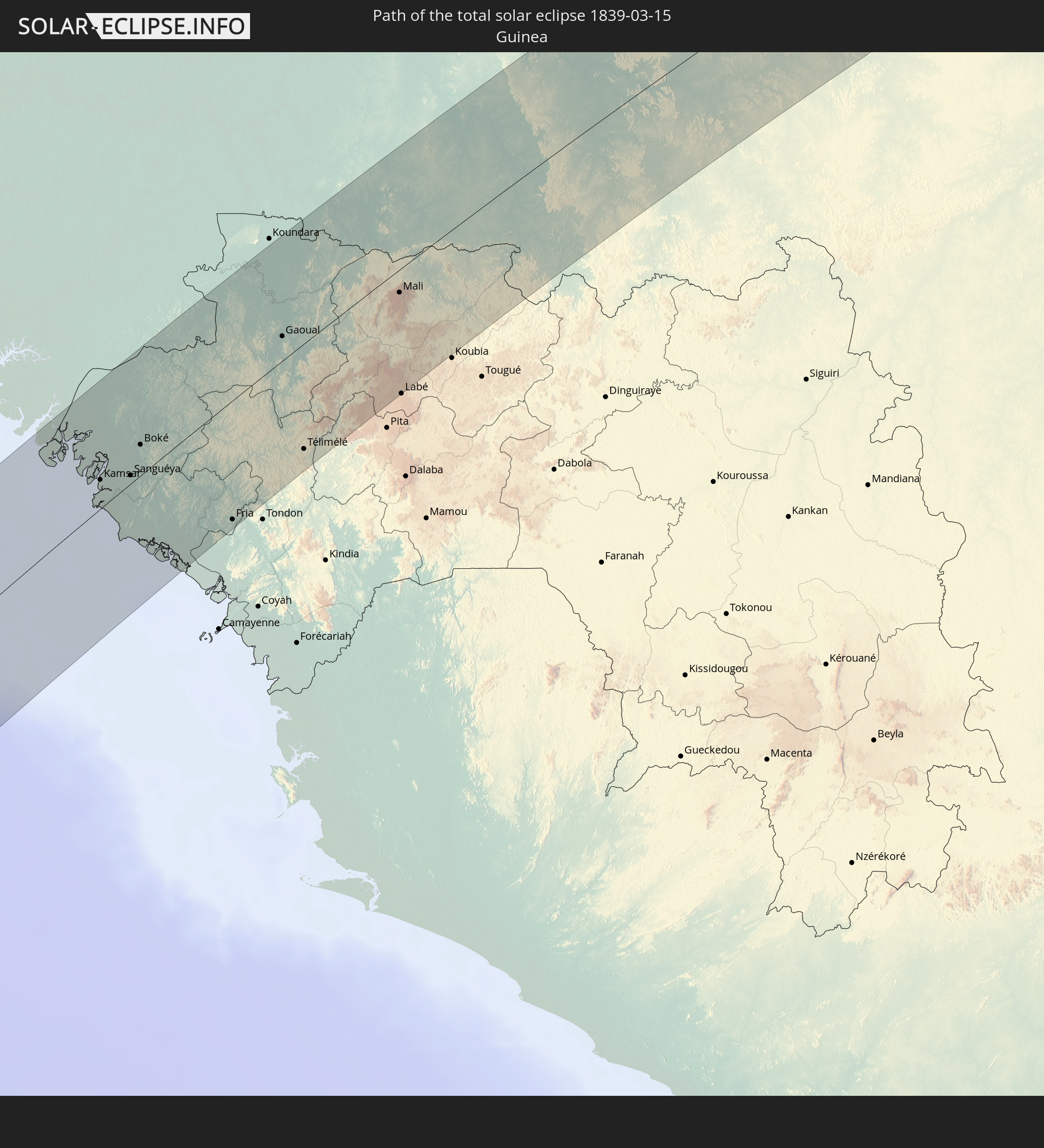 Guinea
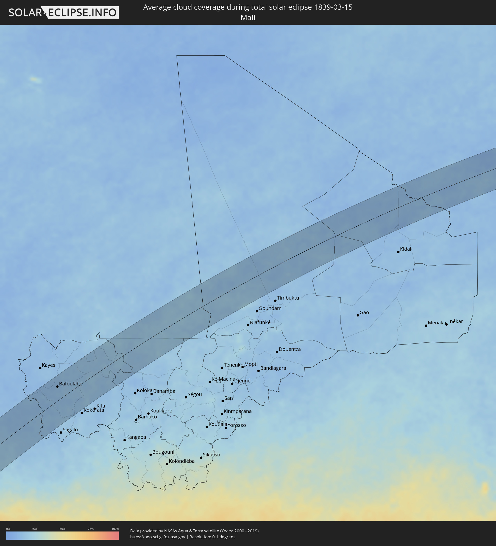
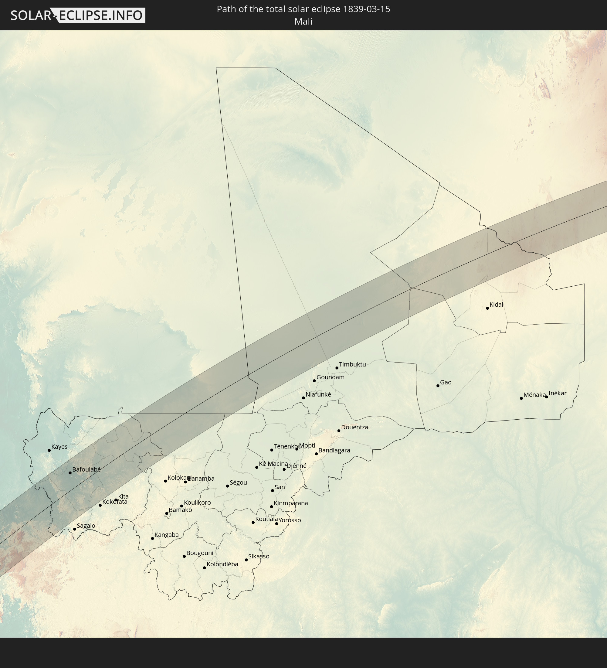 Mali
Mali
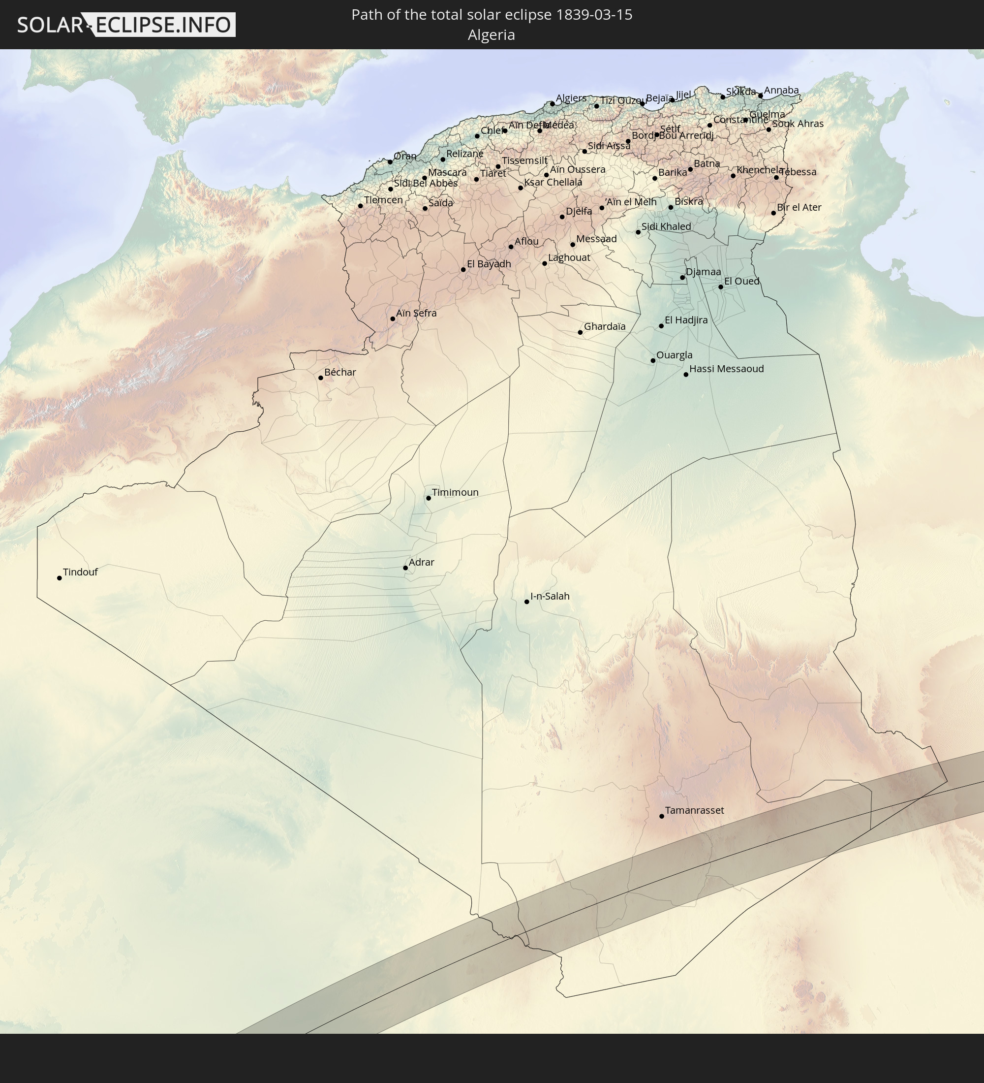 Algerien
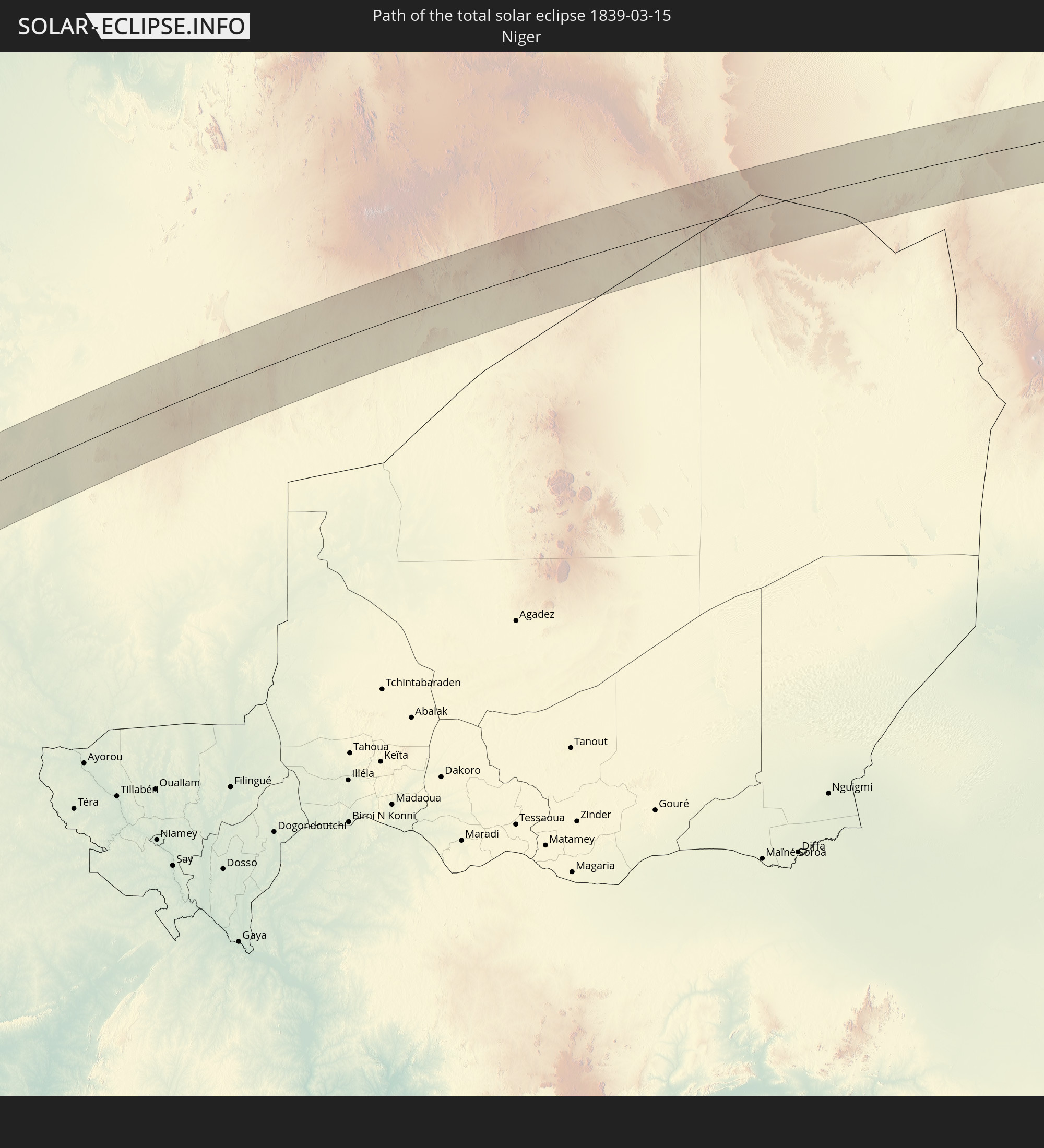 Niger
Niger
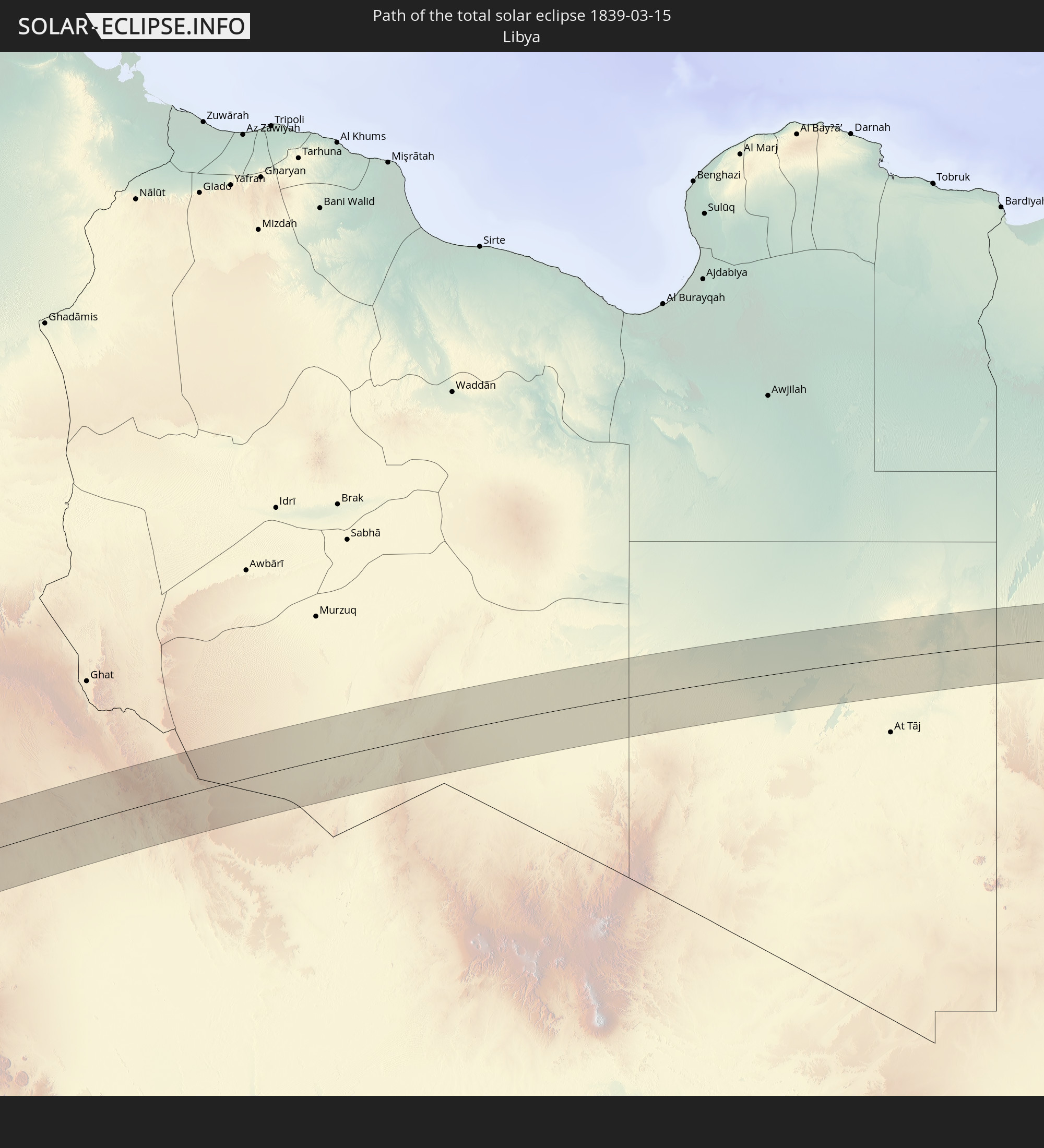 Libyen
 Ägypten
In den folgenden Ländern ist die Sonnenfinsternis partiell zu sehen
 Russland
 Antarktika
 Chile
Chile
 Ecuador
 Kolumbien
 Peru
Peru
 Brasilien
 Argentinien
 Venezuela
 Bolivien
 Paraguay
 Falklandinseln
 Guyana
 Uruguay
 Suriname
 Französisch-Guayana
 Südgeorgien und die Südlichen Sandwichinseln
 Portugal
 Kap Verde
 Spanien
 Senegal
 Mauretanien
 Gambia
 Guinea-Bissau
 Guinea
 St. Helena
 Sierra Leone
 Marokko
 Mali
Mali
 Liberia
 Algerien
 Vereinigtes Königreich
 Elfenbeinküste
 Burkina Faso
 Gibraltar
 Frankreich
 Ghana
Ghana
 Guernsey
 Jersey
 Togo
Togo
 Niger
Niger
 Benin
Benin
 Andorra
 Belgien
 Nigeria
 Niederlande
 Äquatorialguinea
 Luxemburg
 Deutschland
 Schweiz
 São Tomé und Príncipe
 Italien
 Monaco
 Tunesien
 Dänemark
 Kamerun
 Gabun
Gabun
 Libyen
 Liechtenstein
 Österreich
 Schweden
 Republik Kongo
 Angola
 Tschechien
 Demokratische Republik Kongo
 San Marino
 Vatikanstadt
 Slowenien
 Tschad
 Kroatien
 Polen
Polen
 Malta
Malta
 Zentralafrikanische Republik
 Bosnien und Herzegowina
 Ungarn
 Slowakei
 Montenegro
 Serbien
 Albanien
 Griechenland
 Rumänien
 Mazedonien
 Litauen
 Lettland
 Estland
 Sudan
Sudan
 Ukraine
 Bulgarien
 Weißrussland
 Ägypten
 Türkei
 Moldawien
 Ruanda
 Burundi
 Tansania
 Uganda
 Äthiopien
 Kenia
Kenia
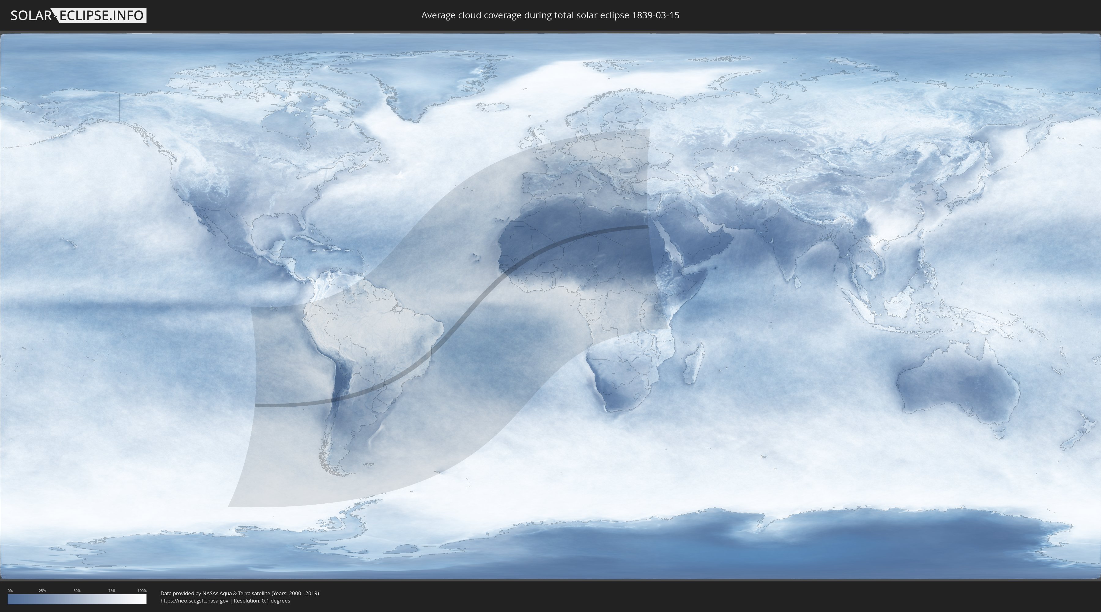
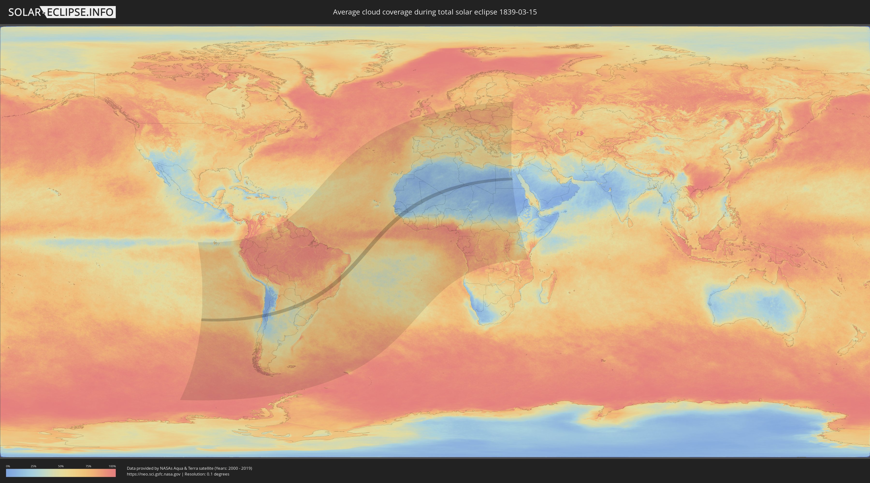
Wie wird das Wetter während der totalen Sonnenfinsternis am 15.03.1839?
Wo ist der beste Ort, um die totale Sonnenfinsternis vom 15.03.1839 zu beobachten?
Die folgenden Karten zeigen die durchschnittliche Bewölkung für den Tag, an dem die totale Sonnenfinsternis
stattfindet. Mit Hilfe der Karten lässt sich der Ort entlang des Finsternispfades eingrenzen,
der die besten Aussichen auf einen klaren wolkenfreien Himmel bietet.
Trotzdem muss man immer lokale Gegenenheiten beachten und sollte sich genau über das Wetter an seinem
gewählten Beobachtungsort informieren.
Die Daten stammen von den beiden NASA-Satelliten
AQUA und TERRA
und wurden über einen Zeitraum von 19 Jahren (2000 - 2019) gemittelt.
Detaillierte Länderkarten
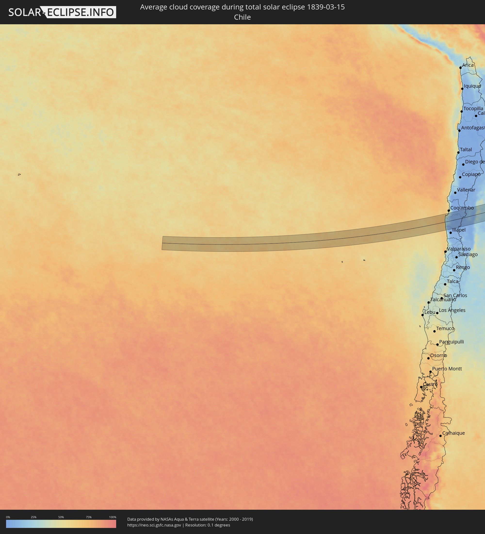 Chile
Chile
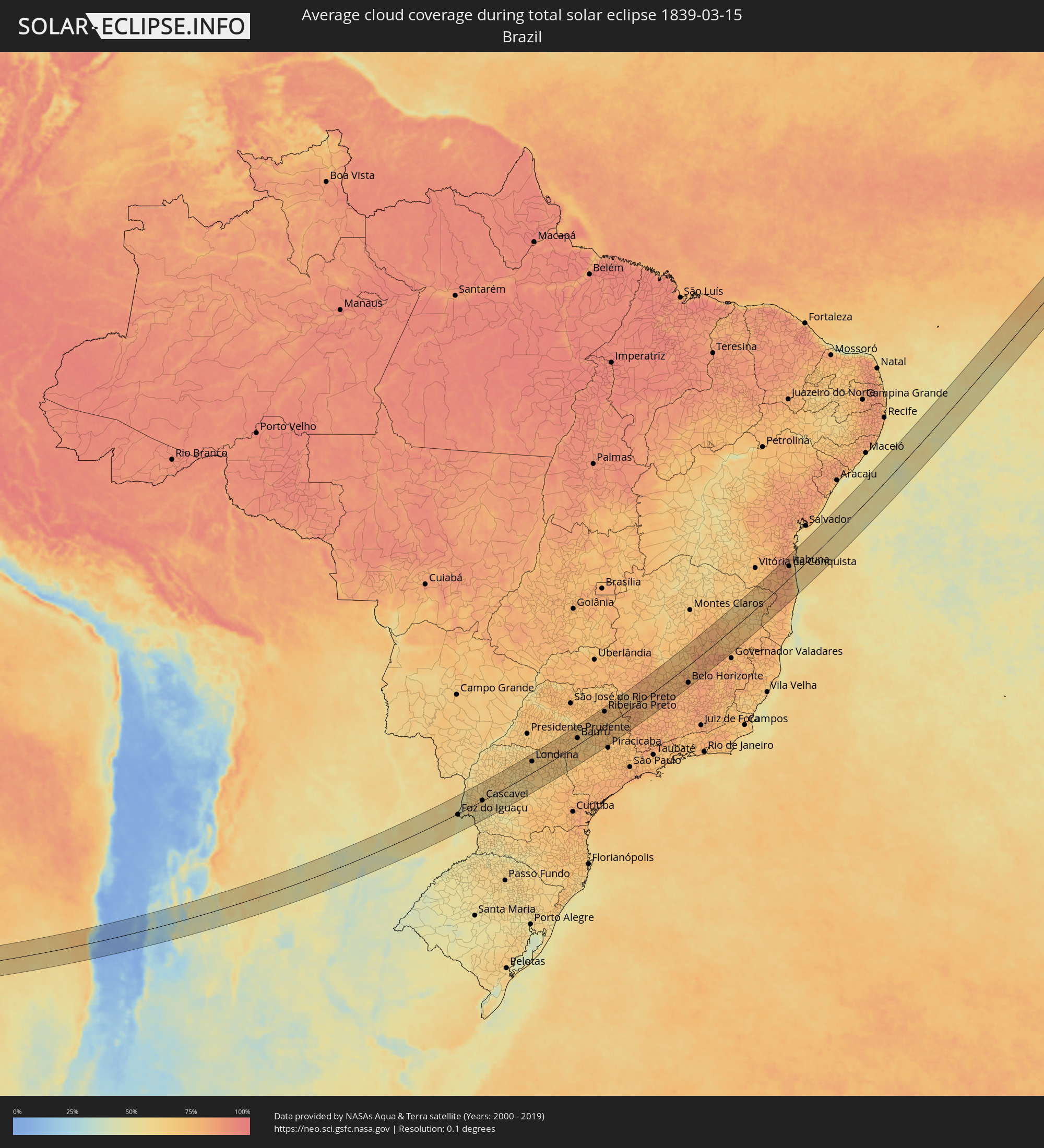 Brasilien
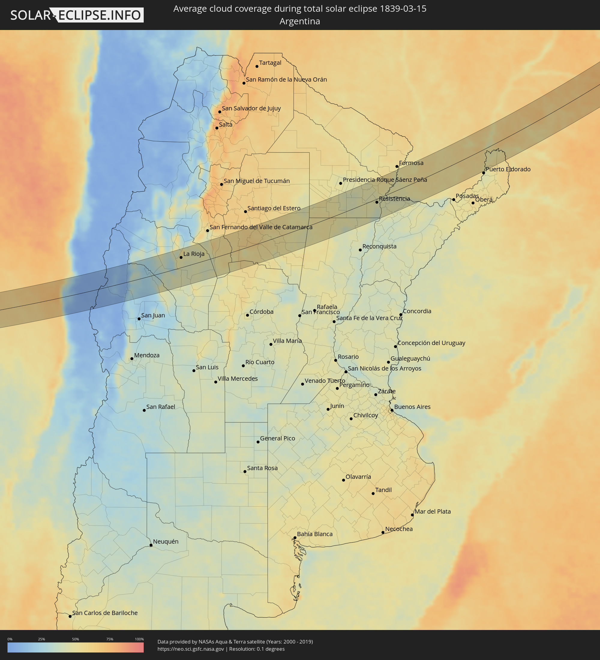 Argentinien
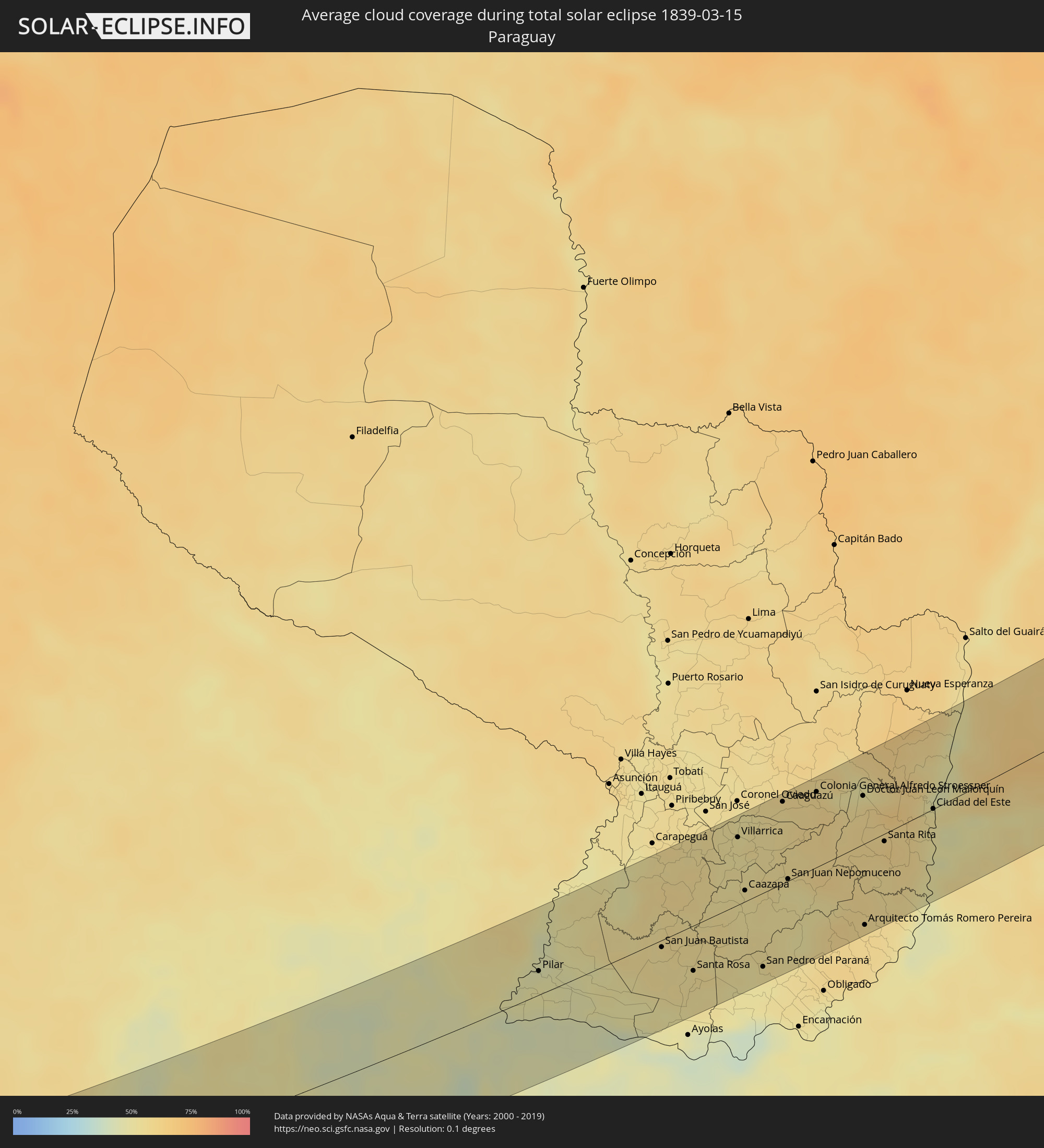 Paraguay
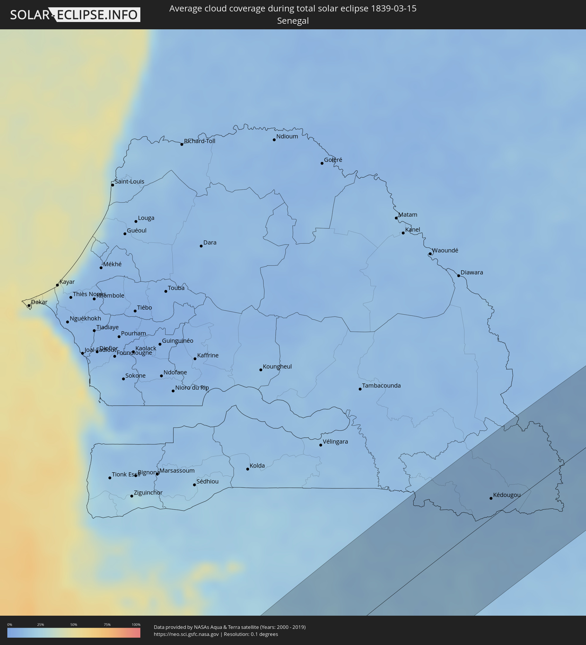 Senegal
 Mauretanien
 Guinea-Bissau
 Guinea
 Mali
Mali
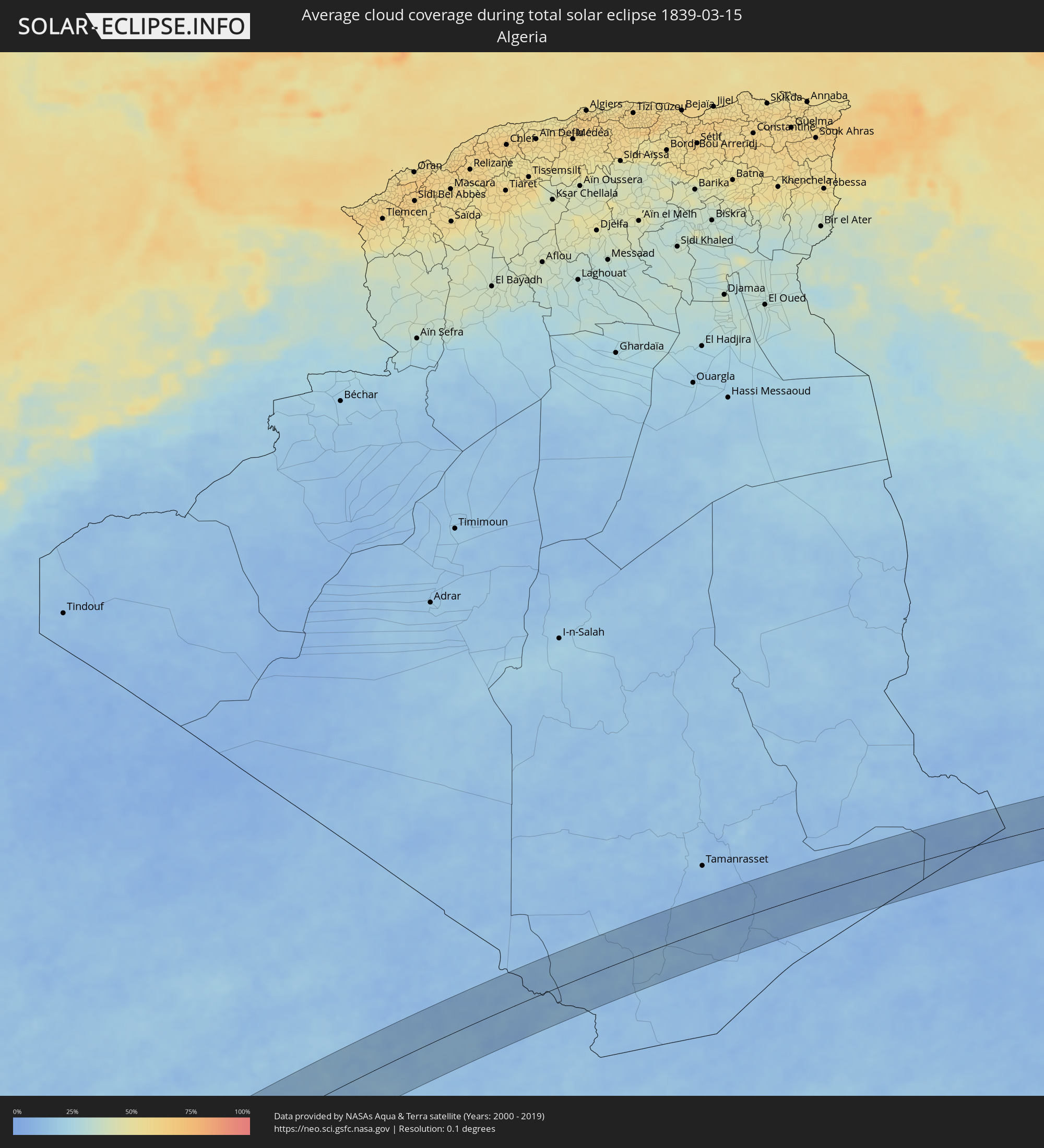 Algerien
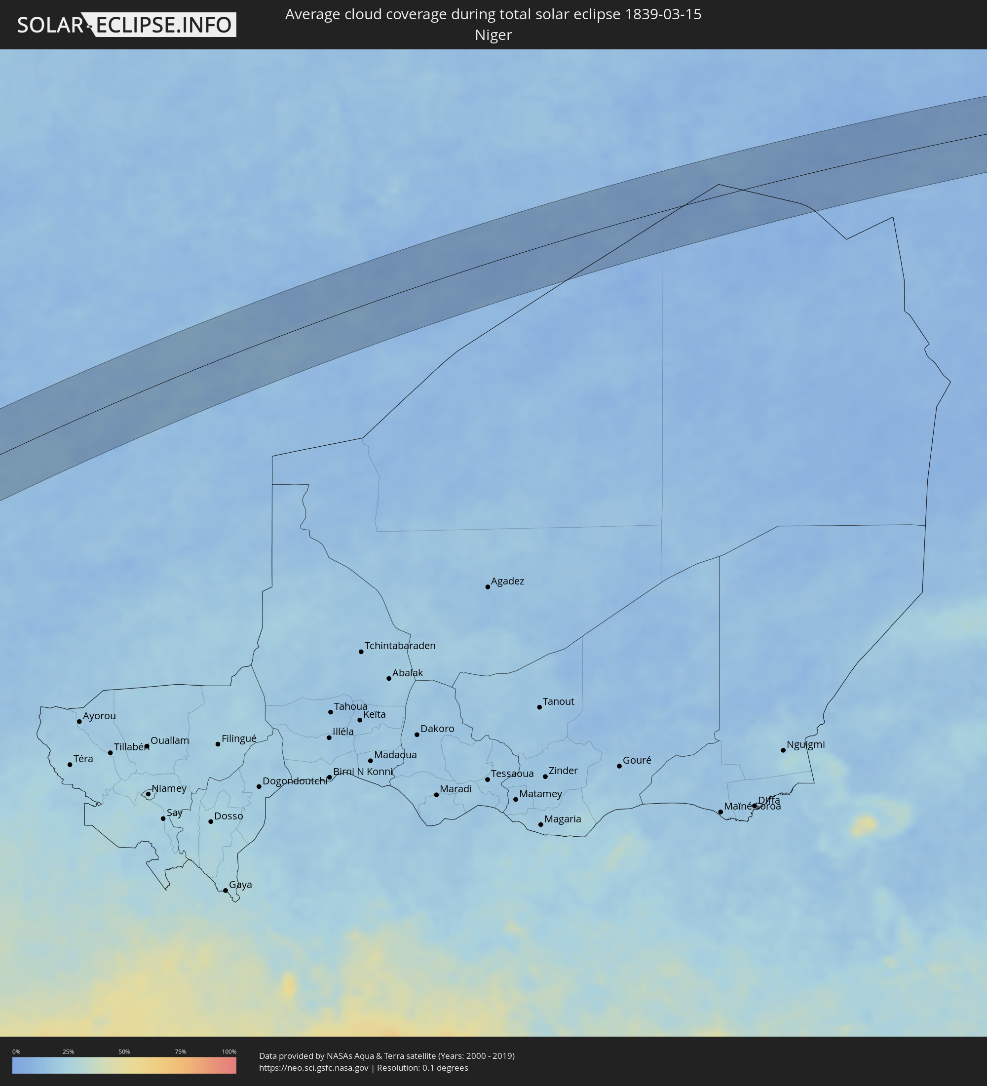 Niger
Niger
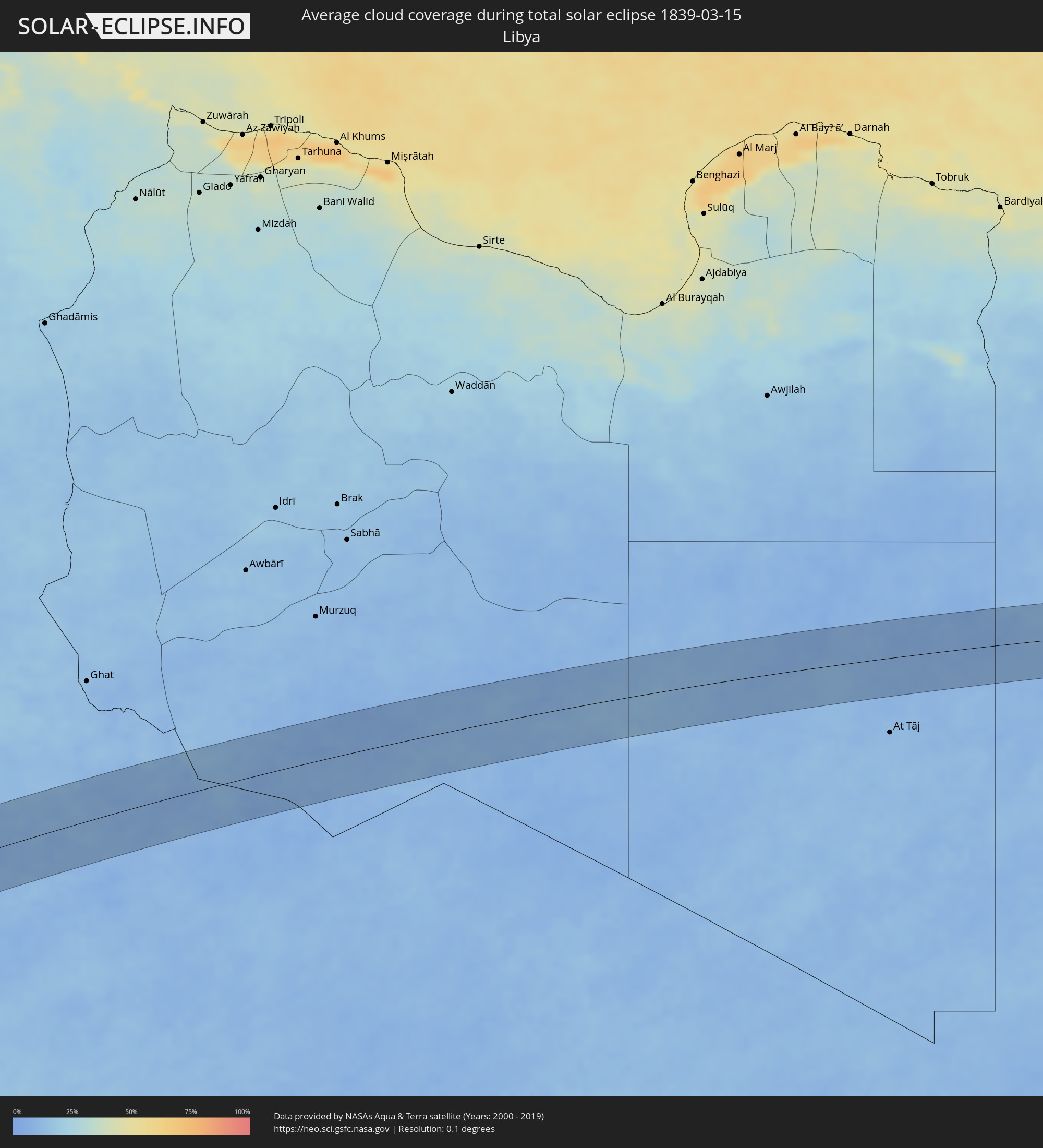 Libyen
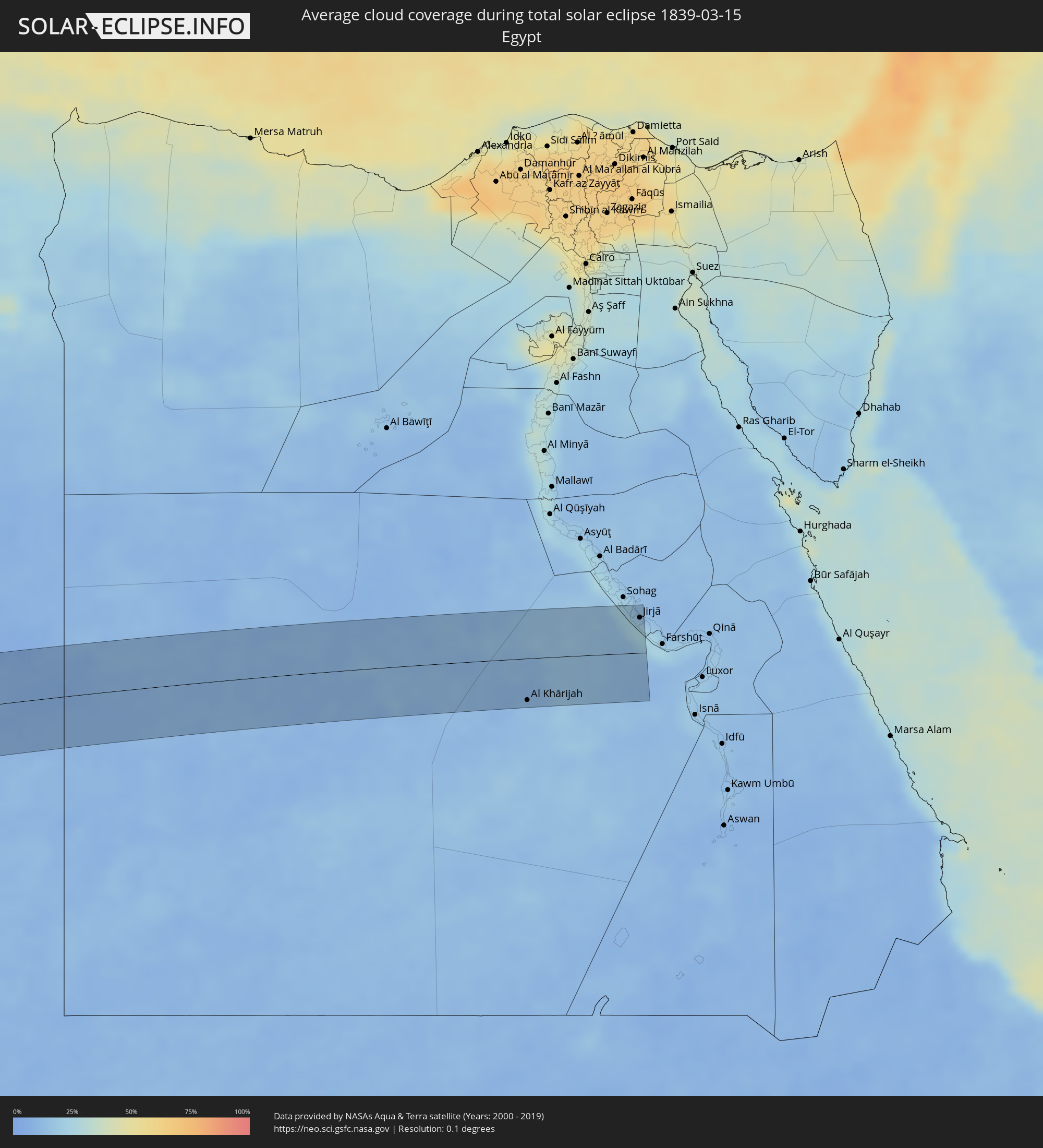 Ägypten
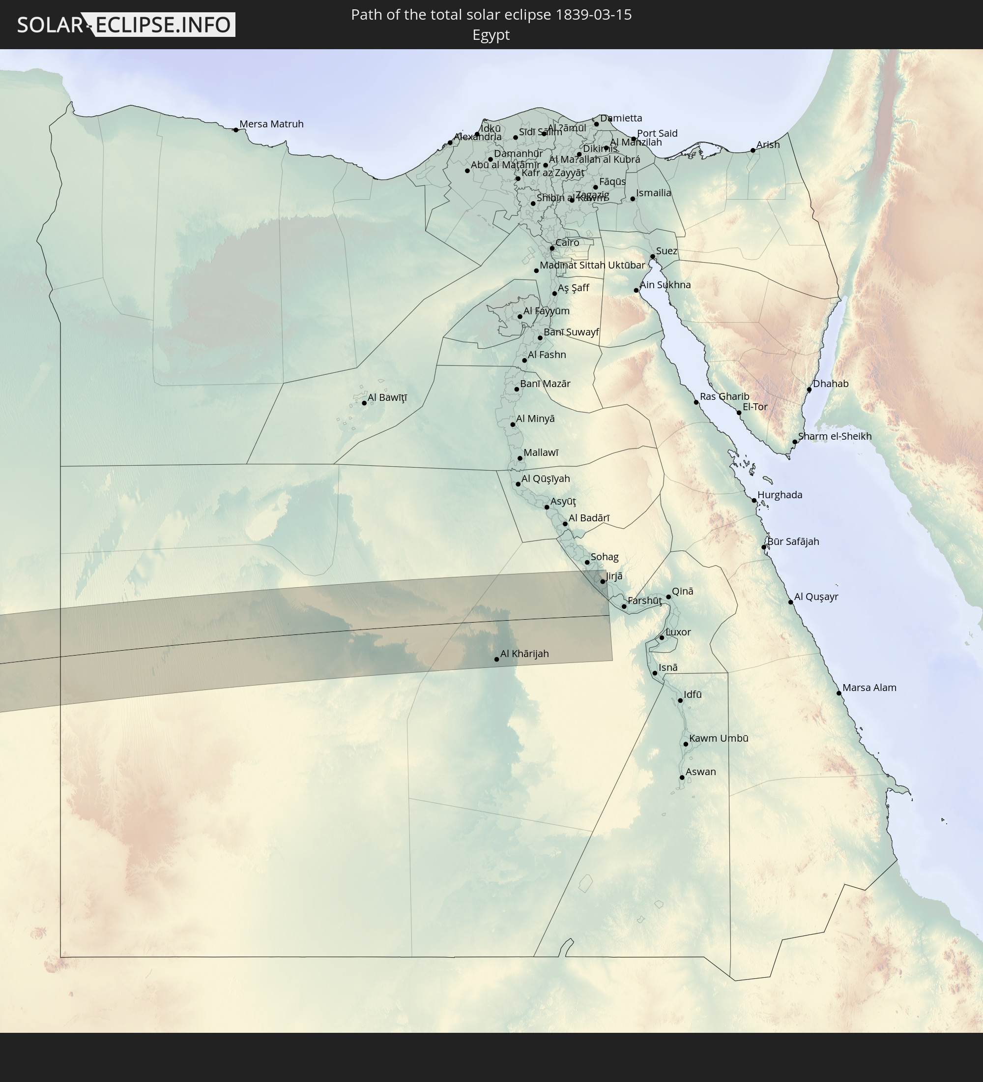
Orte im Finsternispfad
Die nachfolgene Tabelle zeigt Städte und Orte mit mehr als 5.000 Einwohnern, die sich im Finsternispfad befinden. Städte mit mehr als 100.000 Einwohnern sind dick gekennzeichnet. Mit einem Klick auf den Ort öffnet sich eine Detailkarte die die Lage des jeweiligen Ortes zusammen mit dem Verlauf der zentralen Finsternis präsentiert.
| Ort | Typ | Dauer der Verfinsterung | Ortszeit bei maximaler Verfinsterung | Entfernung zur Zentrallinie | Ø Bewölkung |
|
Ovalle, Coquimbo
|
total | - | 07:56:10 UTC-04:42 | 11 km | 14% |
|
Monte Patria, Coquimbo
|
total | - | 07:56:20 UTC-04:42 | 4 km | 6% |
|
Vicuña, Coquimbo
|
total | - | 07:56:40 UTC-04:42 | 63 km | 4% |
|
San José de Jáchal, San Juan Province
|
total | - | 08:24:05 UTC-04:16 | 5 km | 27% |
|
La Rioja, La Rioja Province
|
total | - | 08:25:55 UTC-04:16 | 37 km | 48% |
|
Icaño, Catamarca Province
|
total | - | 08:27:28 UTC-04:16 | 47 km | 54% |
|
Recreo, Catamarca Province
|
total | - | 08:27:34 UTC-04:16 | 0 km | 54% |
|
Villa Ojo de Agua, Santiago del Estero Province
|
total | - | 08:28:45 UTC-04:16 | 64 km | 52% |
|
Añatuya, Santiago del Estero Province
|
total | - | 08:30:05 UTC-04:16 | 19 km | 55% |
|
Hermoso Campo, Chaco Province
|
total | - | 08:32:05 UTC-04:16 | 58 km | 51% |
|
Santa Sylvina, Chaco Province
|
total | - | 08:32:10 UTC-04:16 | 27 km | 53% |
|
Coronel Du Graty, Chaco Province
|
total | - | 08:32:30 UTC-04:16 | 35 km | 50% |
|
Villa Ángela, Chaco Province
|
total | - | 08:32:46 UTC-04:16 | 39 km | 50% |
|
San Bernardo, Chaco Province
|
total | - | 08:32:57 UTC-04:16 | 69 km | 50% |
|
Villa Berthet, Chaco Province
|
total | - | 08:33:17 UTC-04:16 | 57 km | 46% |
|
Presidencia de la Plaza, Chaco Province
|
total | - | 08:34:06 UTC-04:16 | 66 km | 44% |
|
Puerto Tirol, Chaco Province
|
total | - | 08:34:42 UTC-04:16 | 1 km | 45% |
|
Fontana, Chaco Province
|
total | - | 08:34:44 UTC-04:16 | 8 km | 46% |
|
Resistencia, Chaco Province
|
total | - | 08:34:45 UTC-04:16 | 13 km | 43% |
|
Puerto Vilelas, Chaco Province
|
total | - | 08:34:46 UTC-04:16 | 21 km | 43% |
|
La Leonesa, Chaco Province
|
total | - | 08:35:21 UTC-04:16 | 19 km | 49% |
|
Paso de la Patria, Corrientes Province
|
total | - | 08:35:19 UTC-04:16 | 15 km | 44% |
|
San Luis del Palmar, Corrientes Province
|
total | - | 08:35:13 UTC-04:16 | 35 km | 44% |
|
Pilar, Ñeembucú
|
total | - | 09:02:05 UTC-03:50 | 20 km | 49% |
|
Itatí, Corrientes Province
|
total | - | 08:35:44 UTC-04:16 | 23 km | 43% |
|
Quiindy, Paraguarí
|
total | - | 09:03:58 UTC-03:50 | 70 km | 55% |
|
San Juan Bautista, Misiones
|
total | - | 09:03:35 UTC-03:50 | 6 km | 54% |
|
Santa Rosa, Misiones
|
total | - | 09:03:47 UTC-03:50 | 38 km | 54% |
|
Villarrica, Guairá
|
total | - | 09:05:09 UTC-03:50 | 57 km | 53% |
|
Caazapá, Caazapá
|
total | - | 09:04:53 UTC-03:50 | 9 km | 53% |
|
San Pedro del Paraná, Itapúa
|
total | - | 09:04:36 UTC-03:50 | 62 km | 52% |
|
Caaguazú, Caaguazú
|
total | - | 09:05:55 UTC-03:50 | 69 km | 54% |
|
San Juan Nepomuceno, Caazapá
|
total | - | 09:05:27 UTC-03:50 | 2 km | 52% |
|
Repatriación, Caaguazú
|
total | - | 09:05:56 UTC-03:50 | 58 km | 54% |
|
Colonia General Alfredo Stroessner, Caaguazú
|
total | - | 09:06:24 UTC-03:50 | 63 km | 58% |
|
Doctor Juan León Mallorquín, Alto Paraná
|
total | - | 09:06:55 UTC-03:50 | 41 km | 55% |
|
Arquitecto Tomás Romero Pereira, Itapúa
|
total | - | 09:06:02 UTC-03:50 | 68 km | 58% |
|
Santa Rita, Alto Paraná
|
total | - | 09:06:51 UTC-03:50 | 6 km | 57% |
|
Puerto Esperanza, Misiones Province
|
total | - | 08:41:01 UTC-04:16 | 47 km | 51% |
|
Puerto Libertad, Misiones Province
|
total | - | 09:07:18 UTC-03:50 | 40 km | 49% |
|
Presidente Franco, Alto Paraná
|
total | - | 09:07:38 UTC-03:50 | 2 km | 52% |
|
Ciudad del Este, Alto Paraná
|
total | - | 09:07:40 UTC-03:50 | 0 km | 52% |
|
Foz do Iguaçu, Paraná
|
total | - | 09:51:51 UTC-03:06 | 5 km | 52% |
|
Puerto Iguazú, Misiones Province
|
total | - | 08:41:30 UTC-04:16 | 10 km | 51% |
|
Colonia Wanda, Misiones Province
|
total | - | 08:41:22 UTC-04:16 | 54 km | 55% |
|
Toledo, Paraná
|
total | - | 09:53:43 UTC-03:06 | 38 km | 64% |
|
Cascavel, Paraná
|
total | - | 09:53:52 UTC-03:06 | 1 km | 64% |
|
Maringá, Paraná
|
total | - | 09:57:28 UTC-03:06 | 75 km | 68% |
|
Apucarana, Paraná
|
total | - | 09:58:00 UTC-03:06 | 38 km | 64% |
|
Londrina, Paraná
|
total | - | 09:58:41 UTC-03:06 | 46 km | 65% |
|
Bauru, São Paulo
|
total | - | 10:02:52 UTC-03:06 | 26 km | 72% |
|
Jaú, São Paulo
|
total | - | 10:03:39 UTC-03:06 | 0 km | 68% |
|
Botucatu, São Paulo
|
total | - | 10:03:07 UTC-03:06 | 62 km | 71% |
|
Araraquara, São Paulo
|
total | - | 10:04:50 UTC-03:06 | 24 km | 73% |
|
São Carlos, São Paulo
|
total | - | 10:04:59 UTC-03:06 | 13 km | 75% |
|
Ribeirão Preto, São Paulo
|
total | - | 10:06:10 UTC-03:06 | 60 km | 76% |
|
Rio Claro, São Paulo
|
total | - | 10:05:00 UTC-03:06 | 68 km | 74% |
|
Araras, São Paulo
|
total | - | 10:05:20 UTC-03:06 | 73 km | 71% |
|
Poços de Caldas, Minas Gerais
|
total | - | 10:07:19 UTC-03:06 | 70 km | 80% |
|
Divinópolis, Minas Gerais
|
total | - | 10:12:09 UTC-03:06 | 25 km | 79% |
|
Esmeraldas, Minas Gerais
|
total | - | 10:13:38 UTC-03:06 | 28 km | 77% |
|
Sete Lagoas, Minas Gerais
|
total | - | 10:14:10 UTC-03:06 | 6 km | 79% |
|
Betim, Minas Gerais
|
total | - | 10:13:31 UTC-03:06 | 53 km | 75% |
|
Ribeirão das Neves, Minas Gerais
|
total | - | 10:13:59 UTC-03:06 | 43 km | 81% |
|
Ibirité, Minas Gerais
|
total | - | 10:13:40 UTC-03:06 | 67 km | 79% |
|
Belo Horizonte, Minas Gerais
|
total | - | 10:14:01 UTC-03:06 | 66 km | 83% |
|
Santa Luzia, Minas Gerais
|
total | - | 10:14:22 UTC-03:06 | 58 km | 79% |
|
Itabuna, Bahia
|
total | - | 11:02:41 UTC-02:34 | 44 km | 83% |
|
Ilhéus, Bahia
|
total | - | 11:03:06 UTC-02:34 | 25 km | 61% |
|
Kamsar, Boke
|
total | - | 14:53:44 UTC-00:16 | 19 km | 34% |
|
Sanguéya, Boke
|
total | - | 14:54:08 UTC-00:16 | 5 km | 26% |
|
Boké, Boke
|
total | - | 14:54:37 UTC-00:16 | 20 km | 23% |
|
Fria, Boke
|
total | - | 14:54:47 UTC-00:16 | 78 km | 30% |
|
Kimbo, Boke
|
total | - | 14:54:53 UTC-00:16 | 77 km | 30% |
|
Gaoual, Boke
|
total | - | 14:57:31 UTC-00:16 | 16 km | 17% |
|
Youkounkoun, Boke
|
total | - | 14:58:48 UTC-00:16 | 79 km | 13% |
|
Télimélé, Kindia
|
total | - | 14:56:26 UTC-00:16 | 69 km | 19% |
|
Mali, Labe
|
total | - | 14:59:19 UTC-00:16 | 15 km | 15% |
|
Kédougou, Kédougou
|
total | - | 15:00:12 UTC-00:16 | 19 km | 11% |
|
Bafoulabé, Kayes
|
total | - | 15:03:52 UTC-00:16 | 44 km | 13% |
|
Al Khārijah, New Valley
|
total | - | 17:56:53 UTC+02:00 | 50 km | 13% |
|
Jirjā, Sohag
|
total | - | 17:57:02 UTC+02:00 | 42 km | 25% |