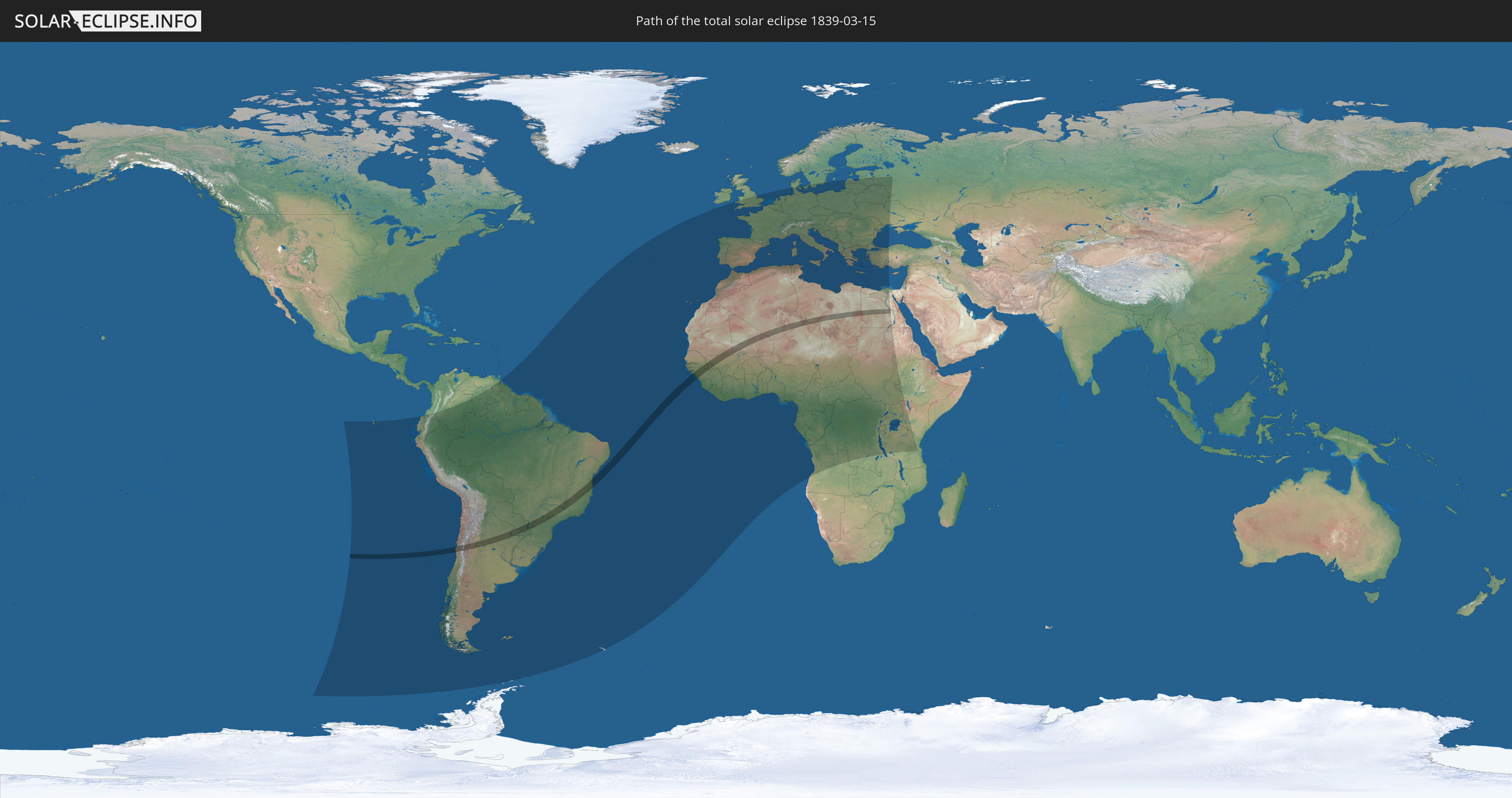
Total solar eclipse of 03/15/1839
| Day of week: | Friday |
| Maximum duration of eclipse: | 04m20s |
| Maximum width of eclipse path: | 172 km |
| Saros cycle: | 127 |
| Coverage: | 100% |
| Magnitude: | 1.052 |
| Gamma: | -0.0558 |
Wo kann man die Sonnenfinsternis vom 03/15/1839 sehen?
Die Sonnenfinsternis am 03/15/1839 kann man in 98 Ländern als partielle Sonnenfinsternis beobachten.
Der Finsternispfad verläuft durch 13 Länder. Nur in diesen Ländern ist sie als total Sonnenfinsternis zu sehen.
In den folgenden Ländern ist die Sonnenfinsternis total zu sehen
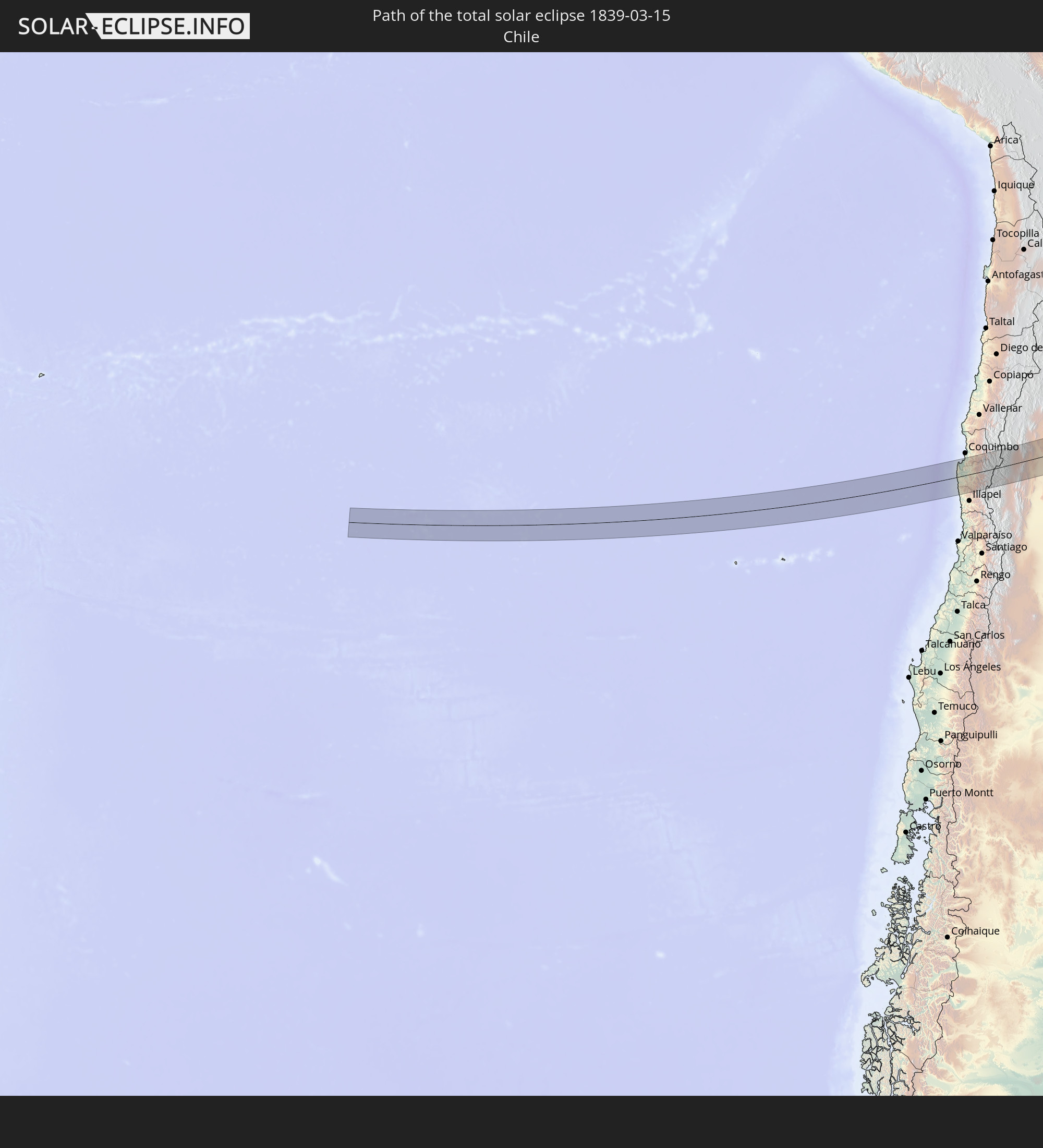 Chile
Chile
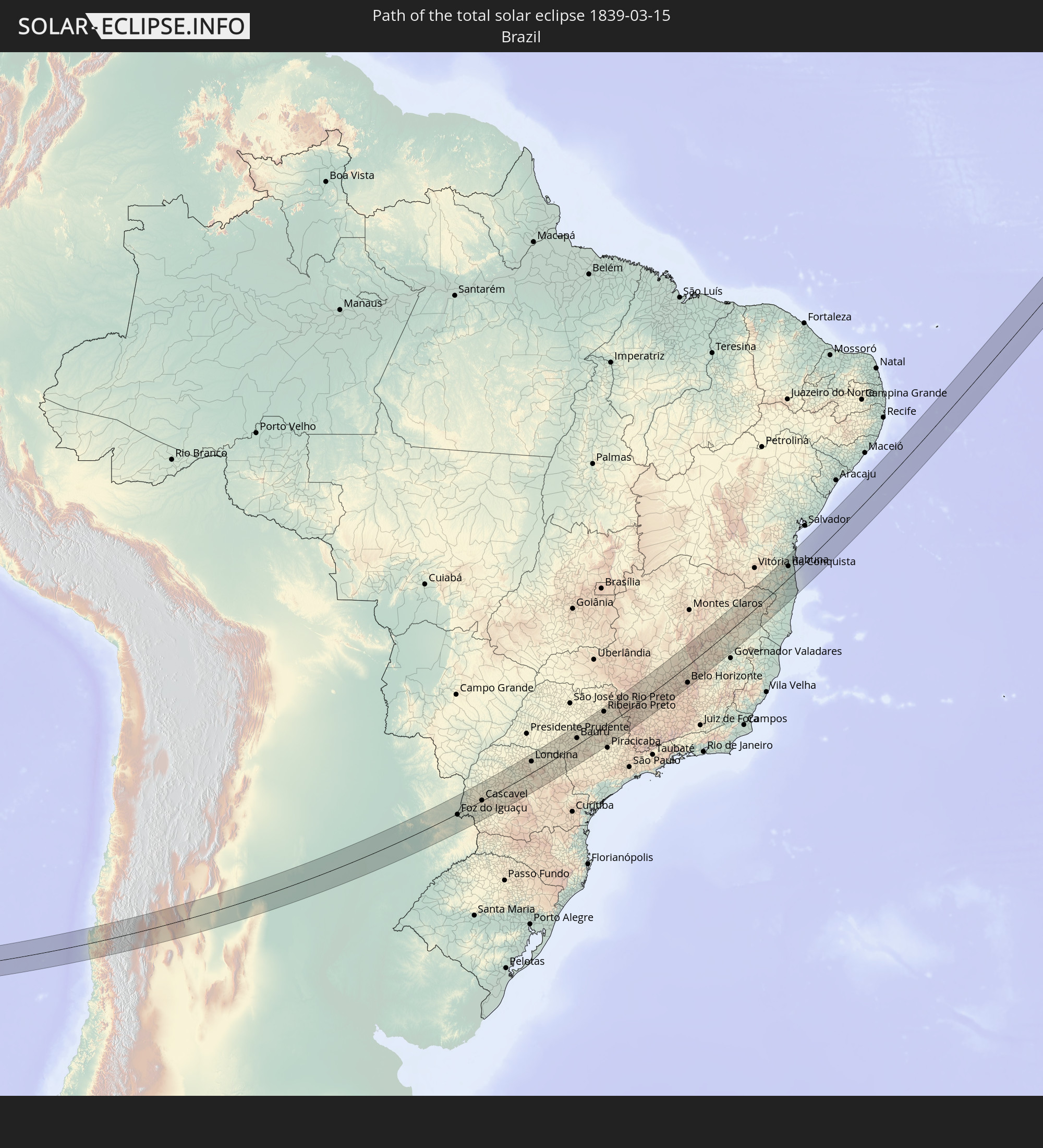 Brazil
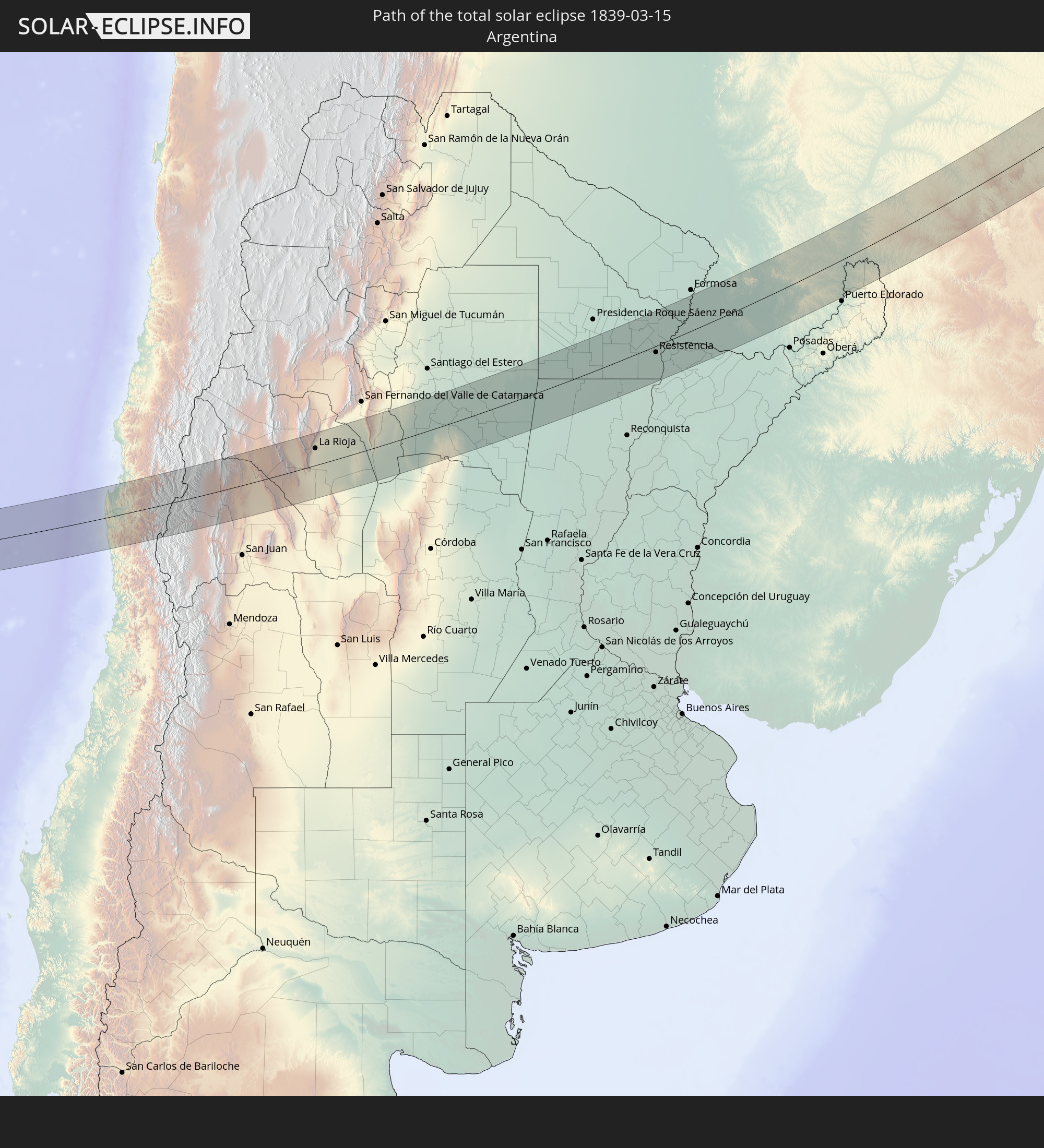 Argentina
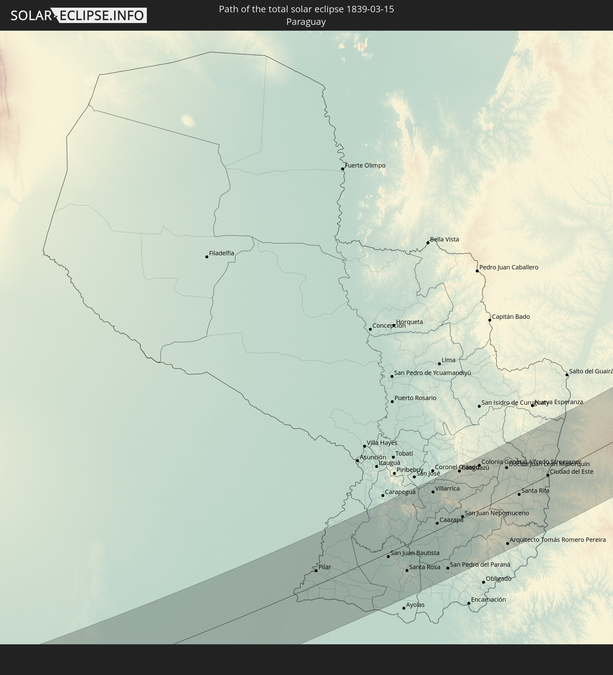 Paraguay
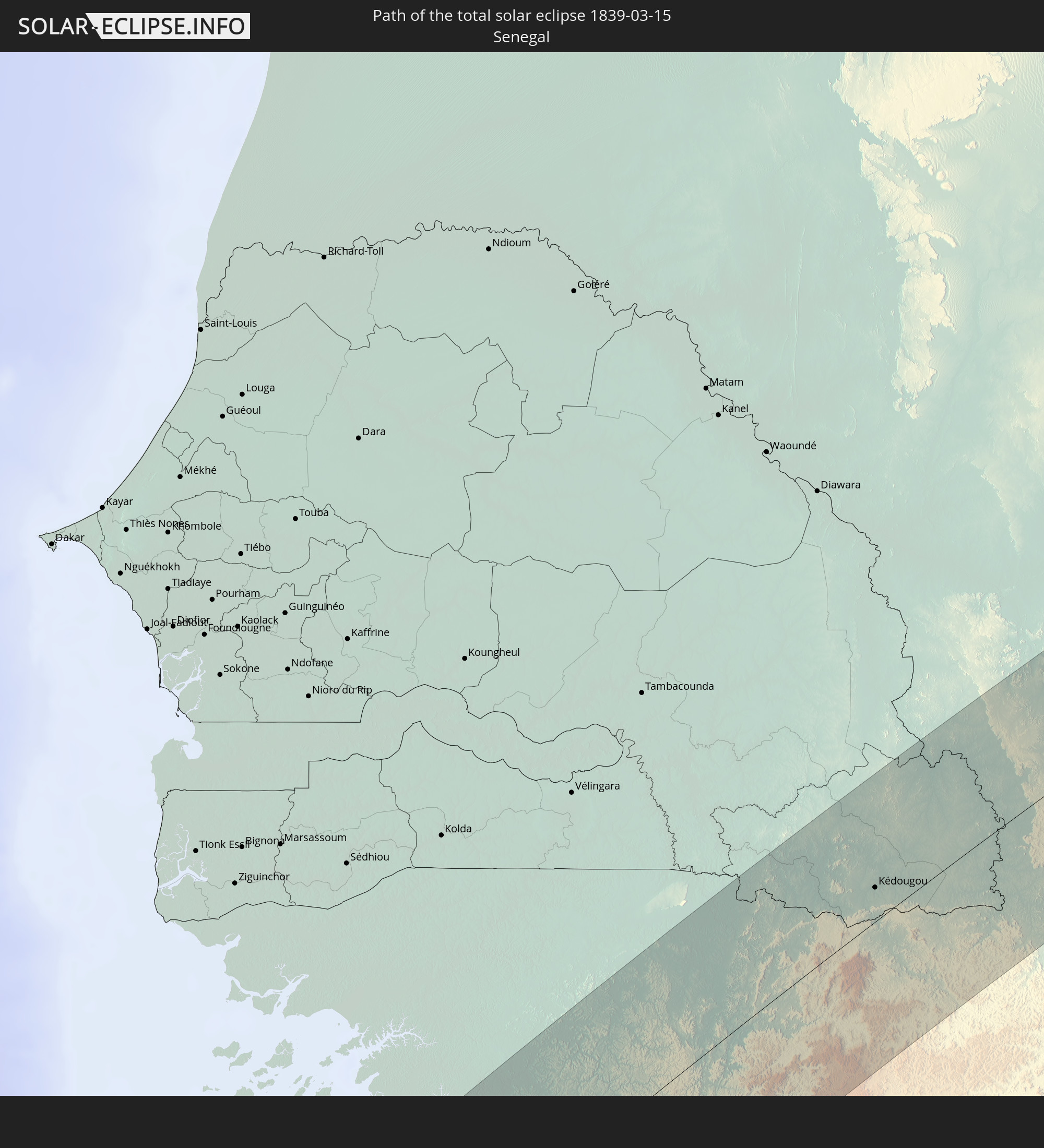 Senegal
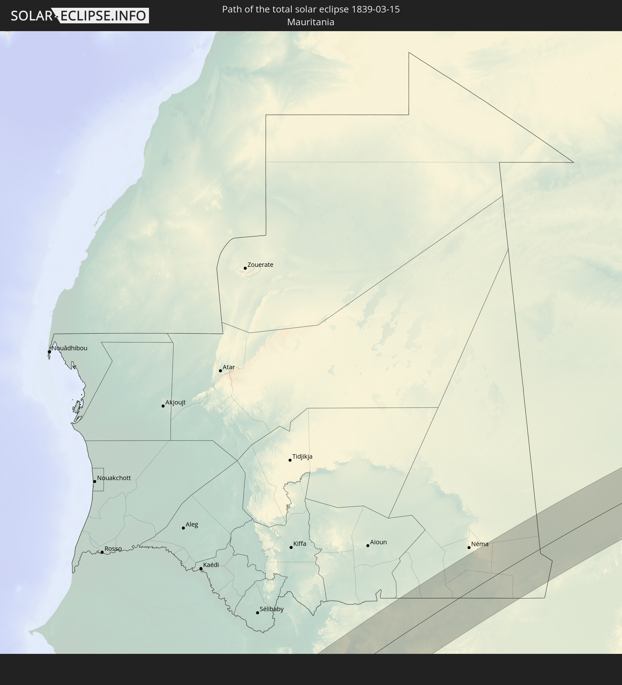 Mauritania
 Guinea-Bissau
 Guinea
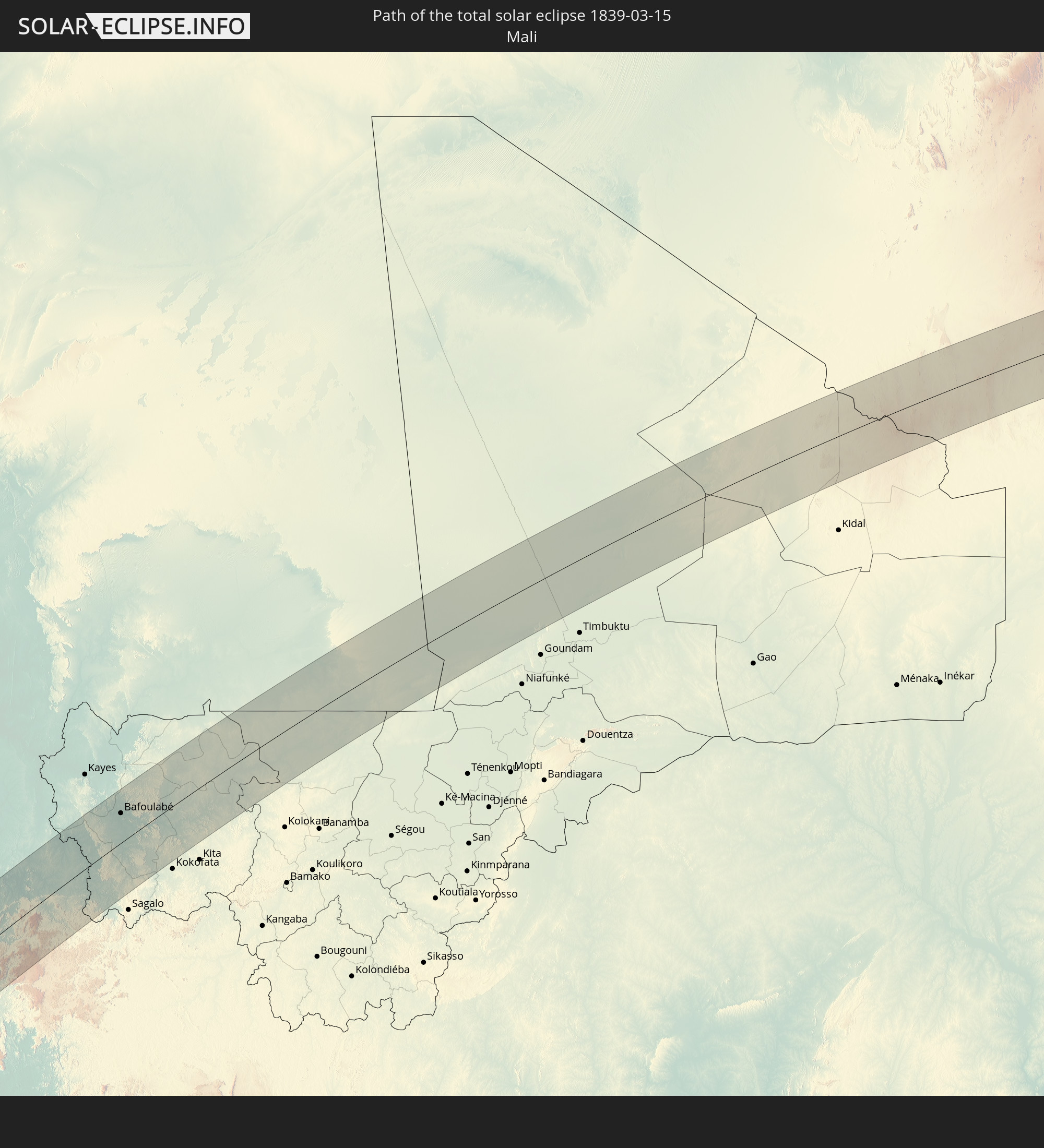 Mali
Mali
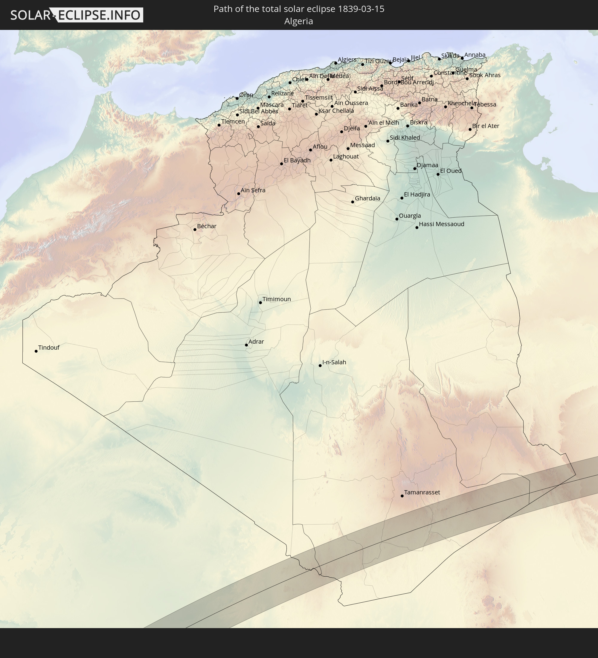 Algeria
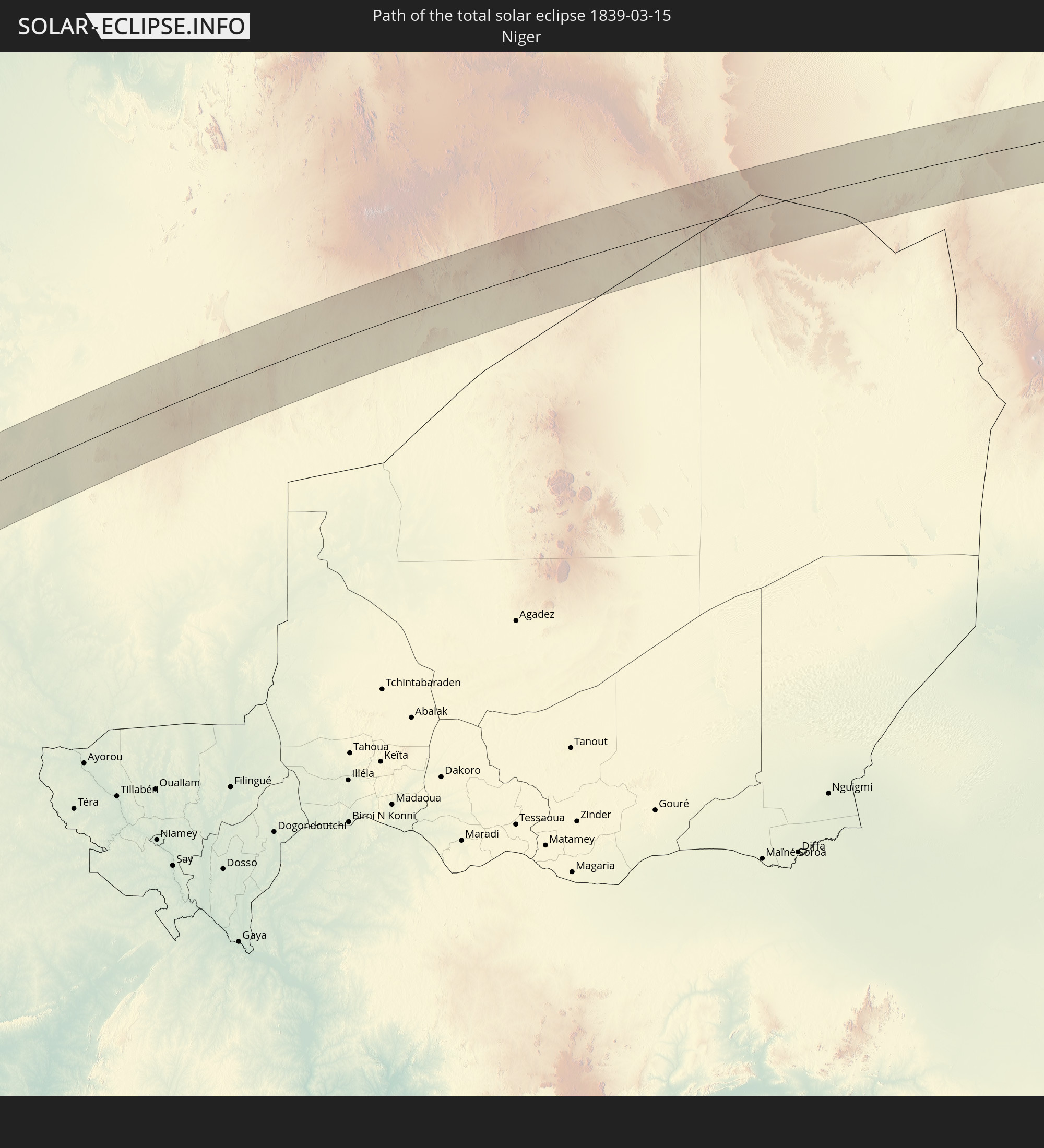 Niger
Niger
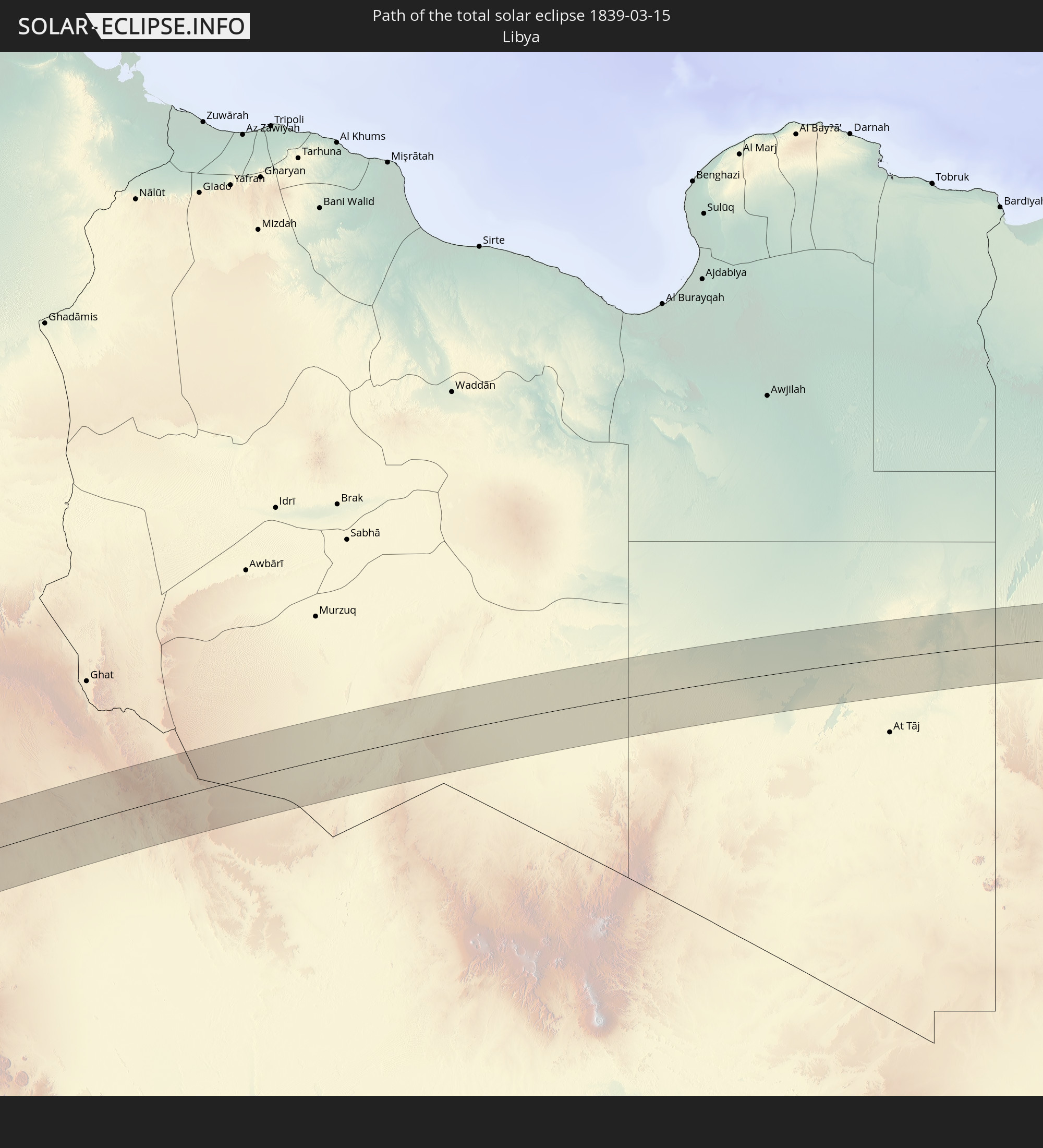 Libya
Libya
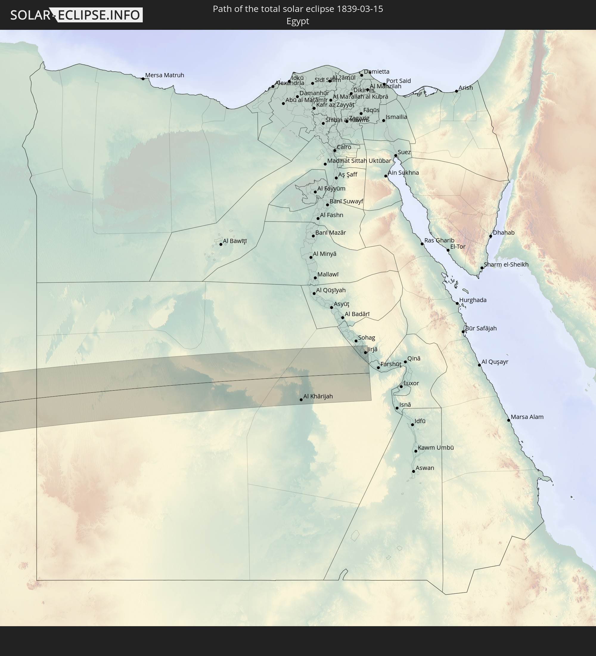 Egypt
Egypt
In den folgenden Ländern ist die Sonnenfinsternis partiell zu sehen
 Russia
 Antarctica
 Chile
Chile
 Ecuador
 Colombia
 Peru
Peru
 Brazil
 Argentina
 Venezuela
 Bolivia
 Paraguay
 Falkland Islands
 Guyana
 Uruguay
 Suriname
 French Guiana
 South Georgia and the South Sandwich Islands
 Portugal
 Cabo Verde
 Spain
Spain
 Senegal
 Mauritania
 The Gambia
 Guinea-Bissau
 Guinea
 Saint Helena, Ascension and Tristan da Cunha
 Sierra Leone
 Morocco
 Mali
Mali
 Liberia
 Algeria
 United Kingdom
 Ivory Coast
 Burkina Faso
 Gibraltar
 France
 Ghana
Ghana
 Guernsey
 Jersey
 Togo
Togo
 Niger
Niger
 Benin
Benin
 Andorra
 Belgium
 Nigeria
 Netherlands
 Equatorial Guinea
 Luxembourg
 Germany
 Switzerland
 São Tomé and Príncipe
 Italy
Italy
 Monaco
 Tunisia
 Denmark
 Cameroon
 Gabon
Gabon
 Libya
Libya
 Liechtenstein
 Austria
 Sweden
 Republic of the Congo
 Angola
 Czechia
 Democratic Republic of the Congo
 San Marino
 Vatican City
 Slovenia
 Chad
Chad
 Croatia
 Poland
 Malta
Malta
 Central African Republic
 Bosnia and Herzegovina
 Hungary
 Slovakia
 Montenegro
 Serbia
 Albania
 Greece
 Romania
 Republic of Macedonia
 Lithuania
 Latvia
 Estonia
 Sudan
Sudan
 Ukraine
 Bulgaria
 Belarus
 Egypt
Egypt
 Turkey
 Moldova
 Rwanda
 Burundi
 Tanzania
 Uganda
 Ethiopia
 Kenya
Kenya
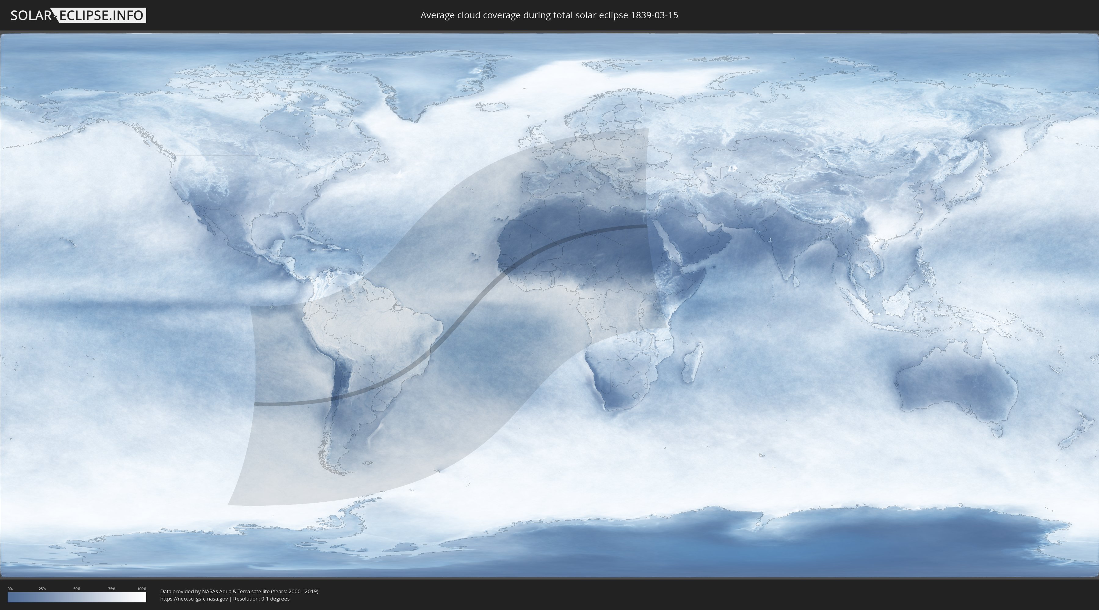
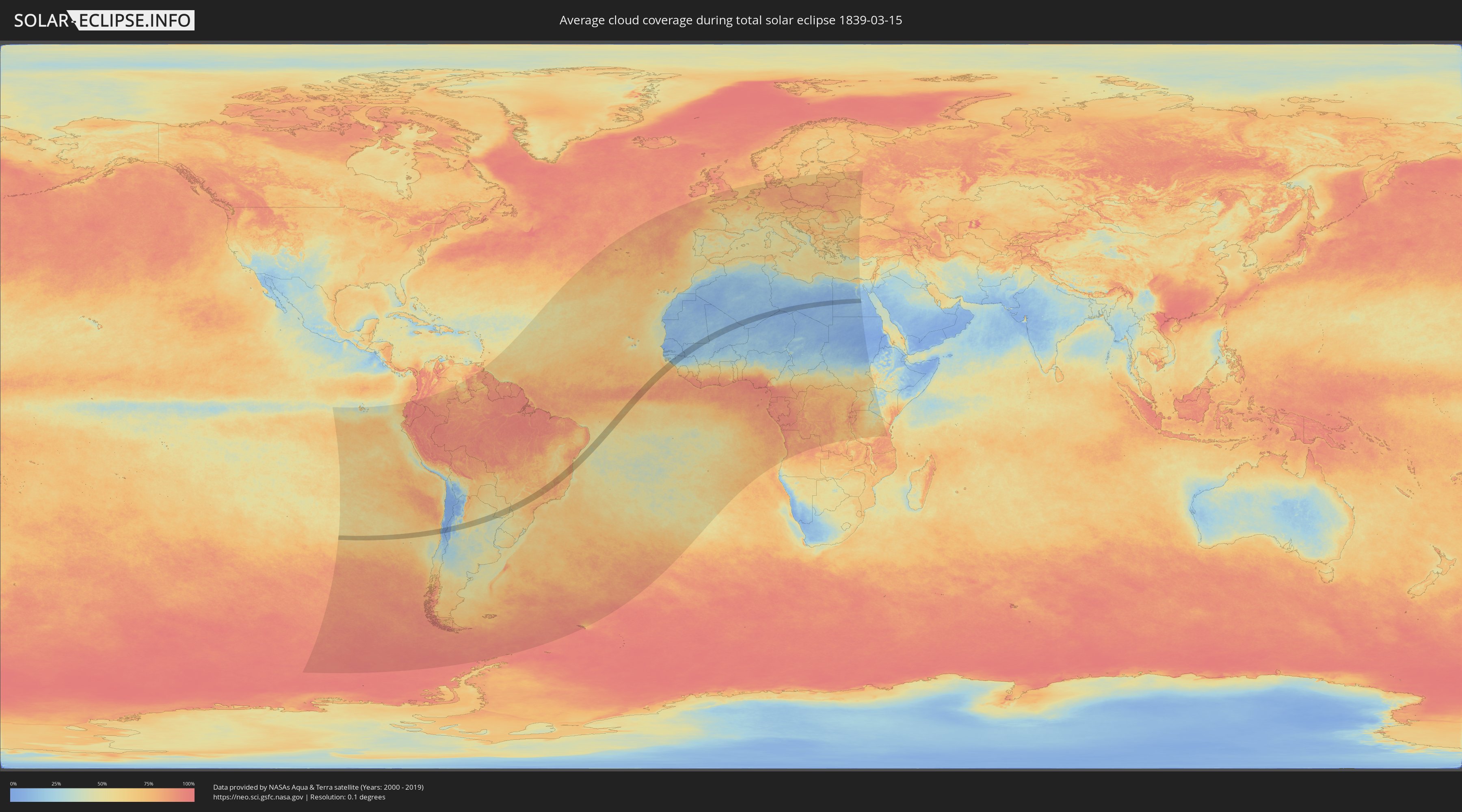
How will be the weather during the total solar eclipse on 03/15/1839?
Where is the best place to see the total solar eclipse of 03/15/1839?
The following maps show the average cloud coverage for the day of the total solar eclipse.
With the help of these maps, it is possible to find the place along the eclipse path, which has the best
chance of a cloudless sky.
Nevertheless, you should consider local circumstances and inform about the weather of your chosen
observation site.
The data is provided by NASAs satellites
AQUA and TERRA.
The cloud maps are averaged over a period of 19 years (2000 - 2019).
Detailed country maps
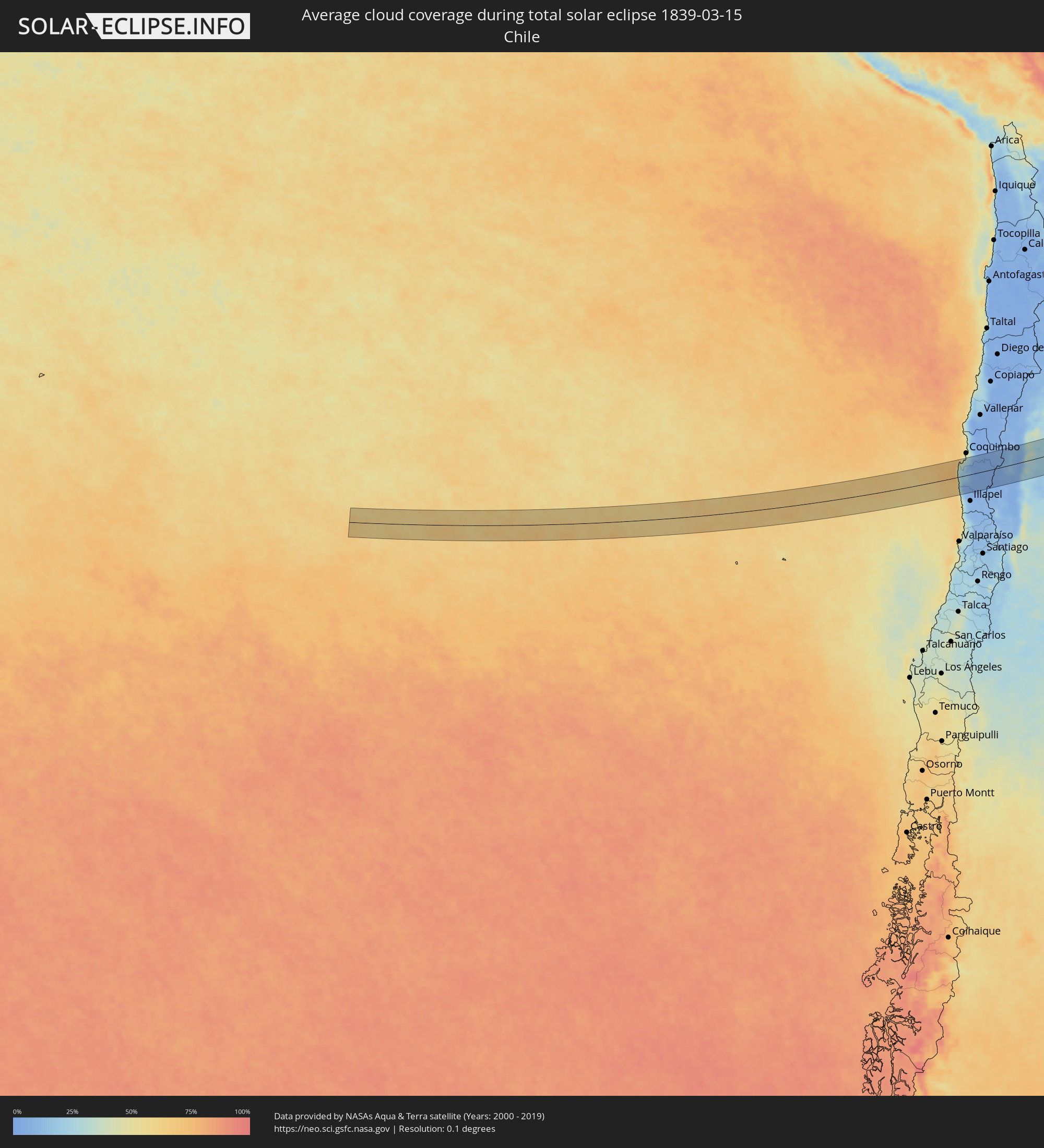 Chile
Chile
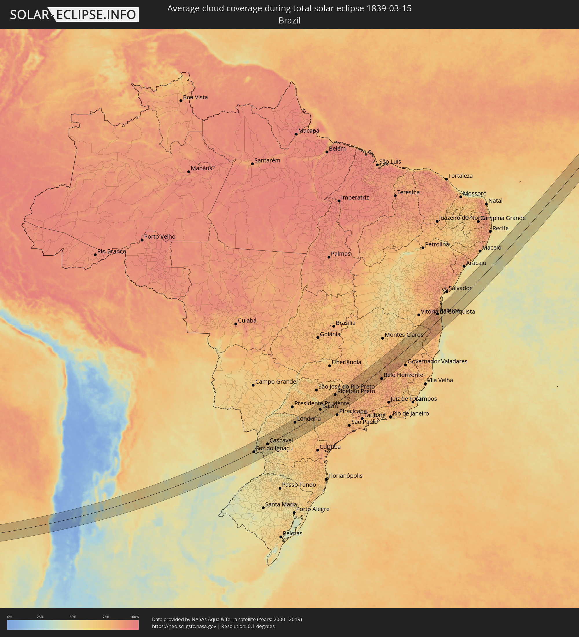 Brazil
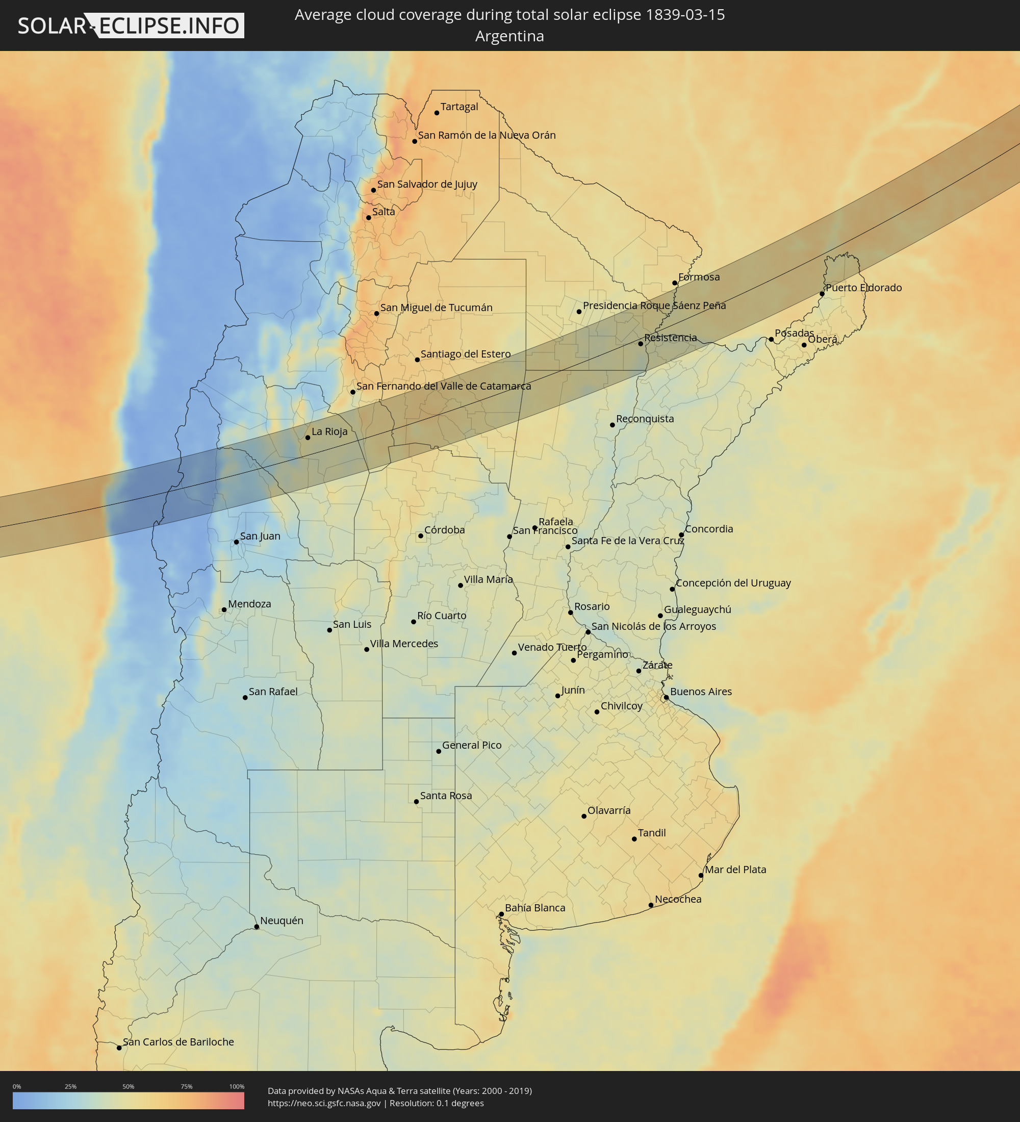 Argentina
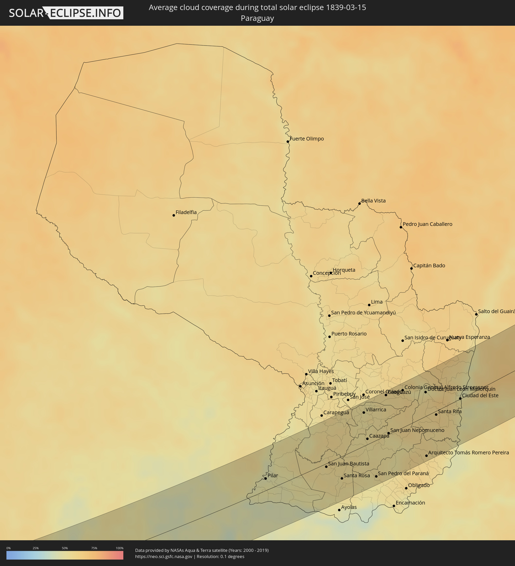 Paraguay
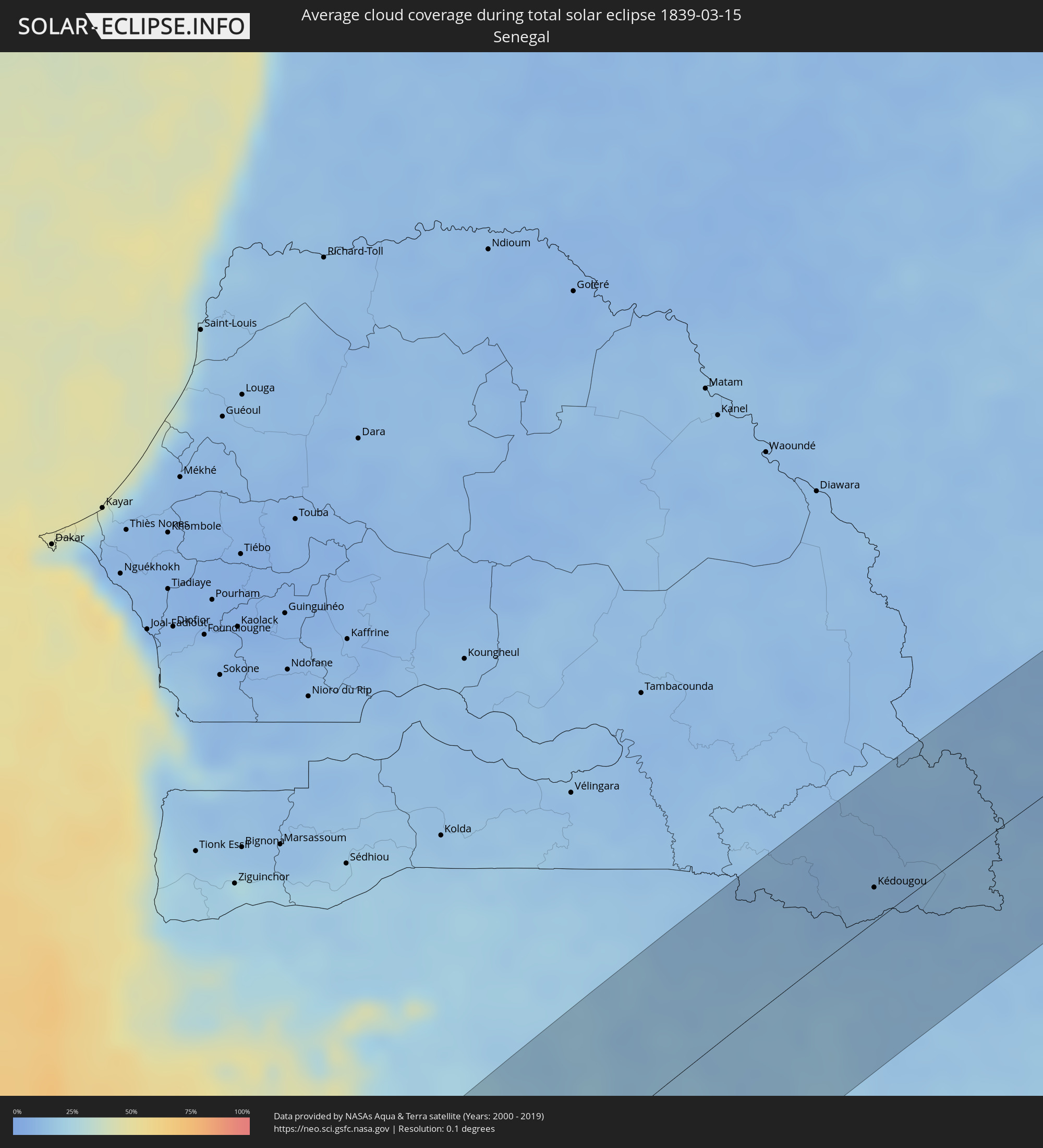 Senegal
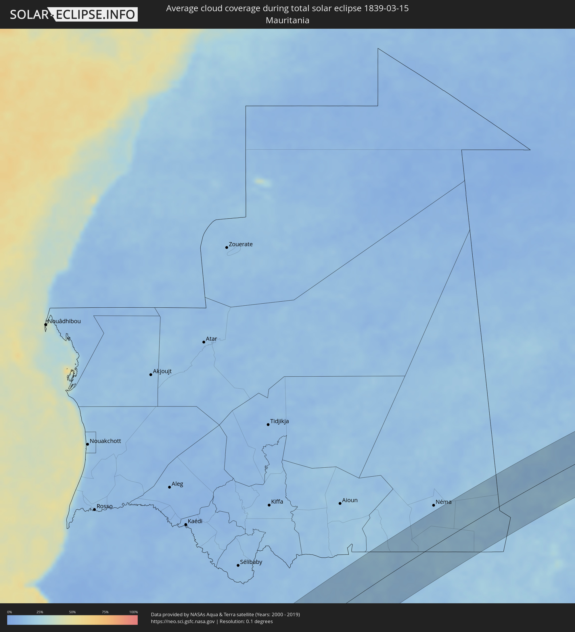 Mauritania
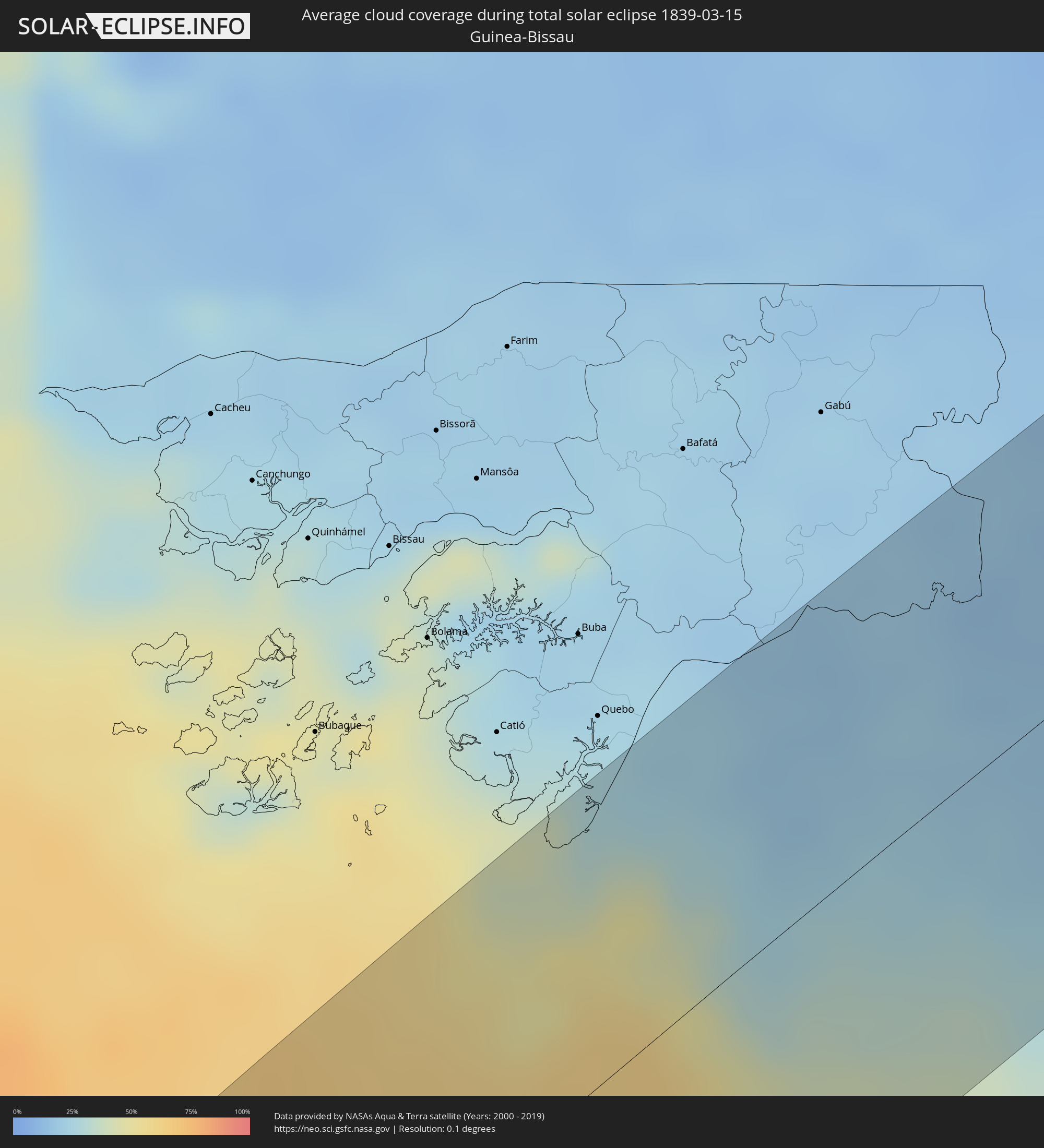 Guinea-Bissau
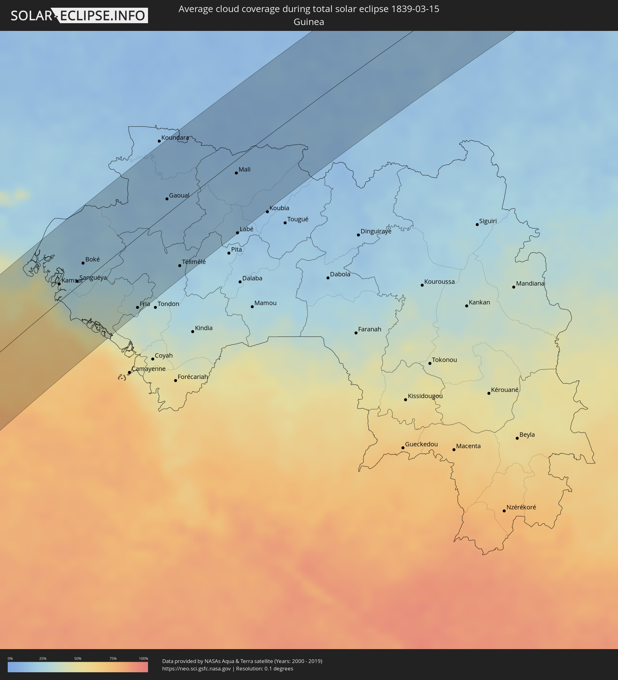 Guinea
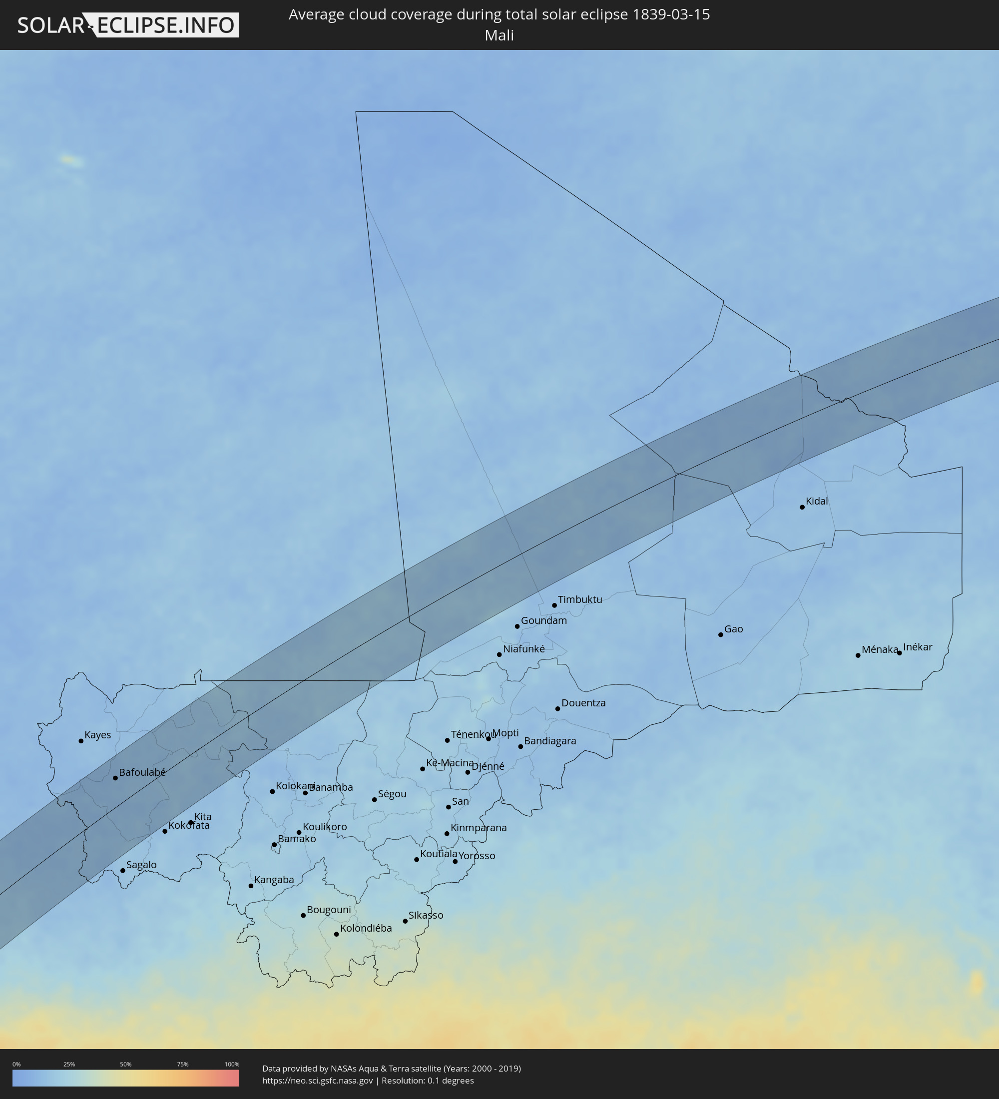 Mali
Mali
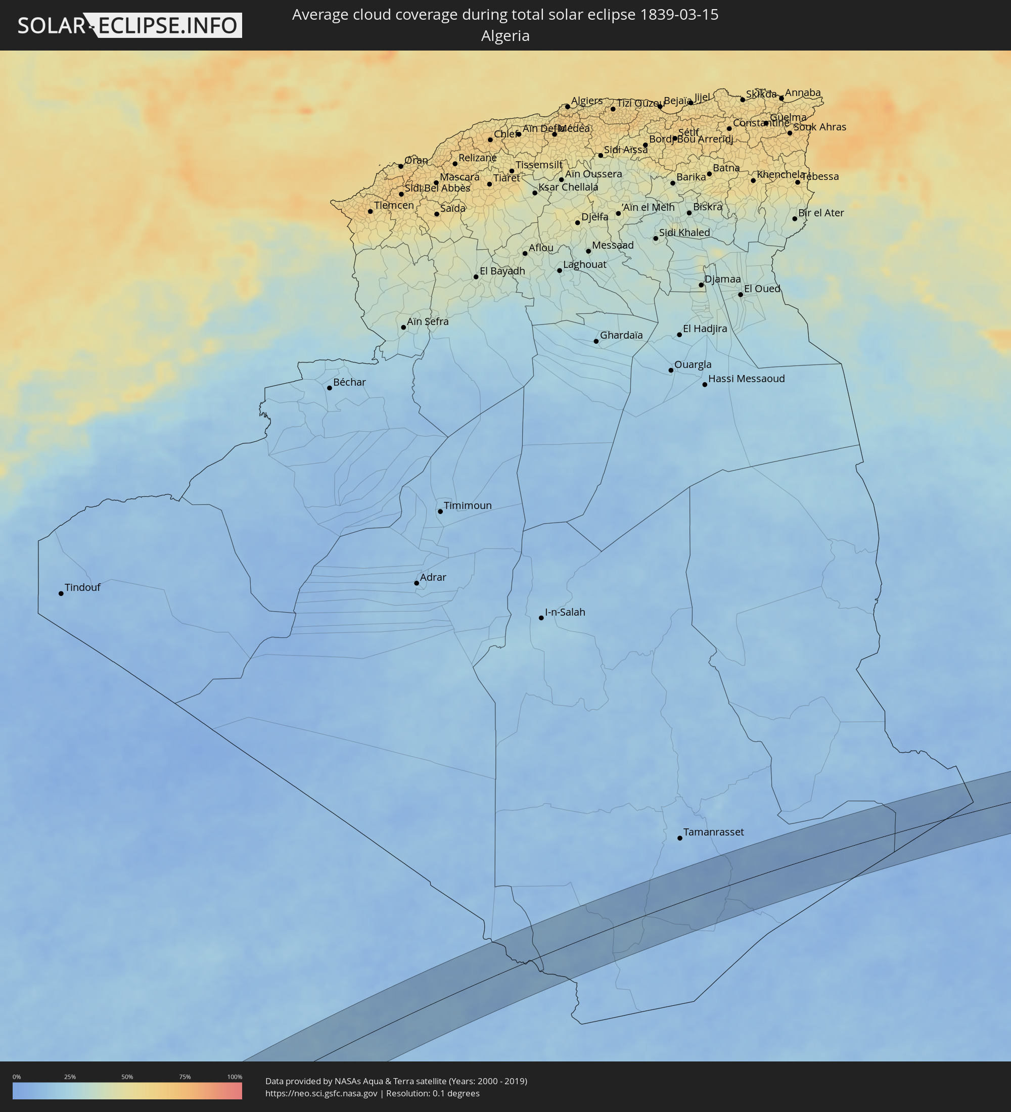 Algeria
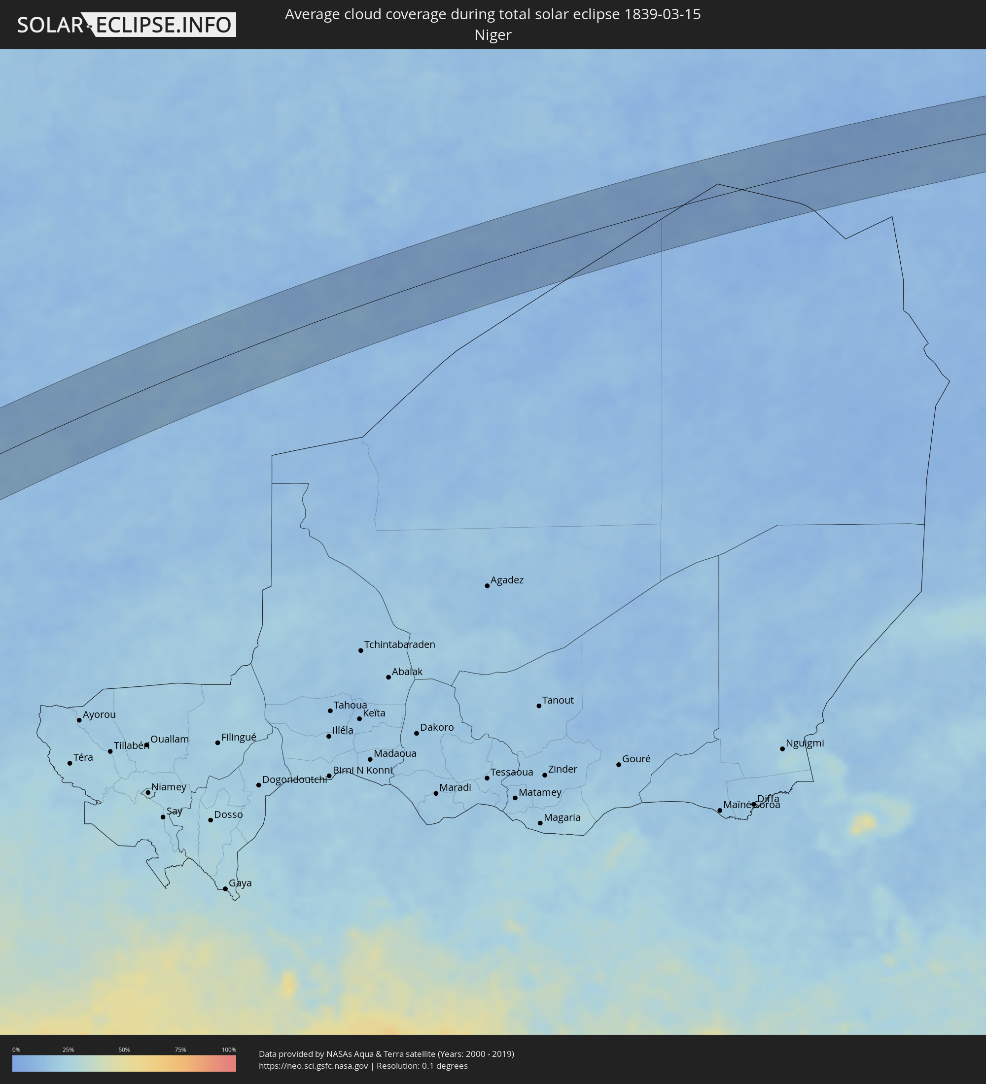 Niger
Niger
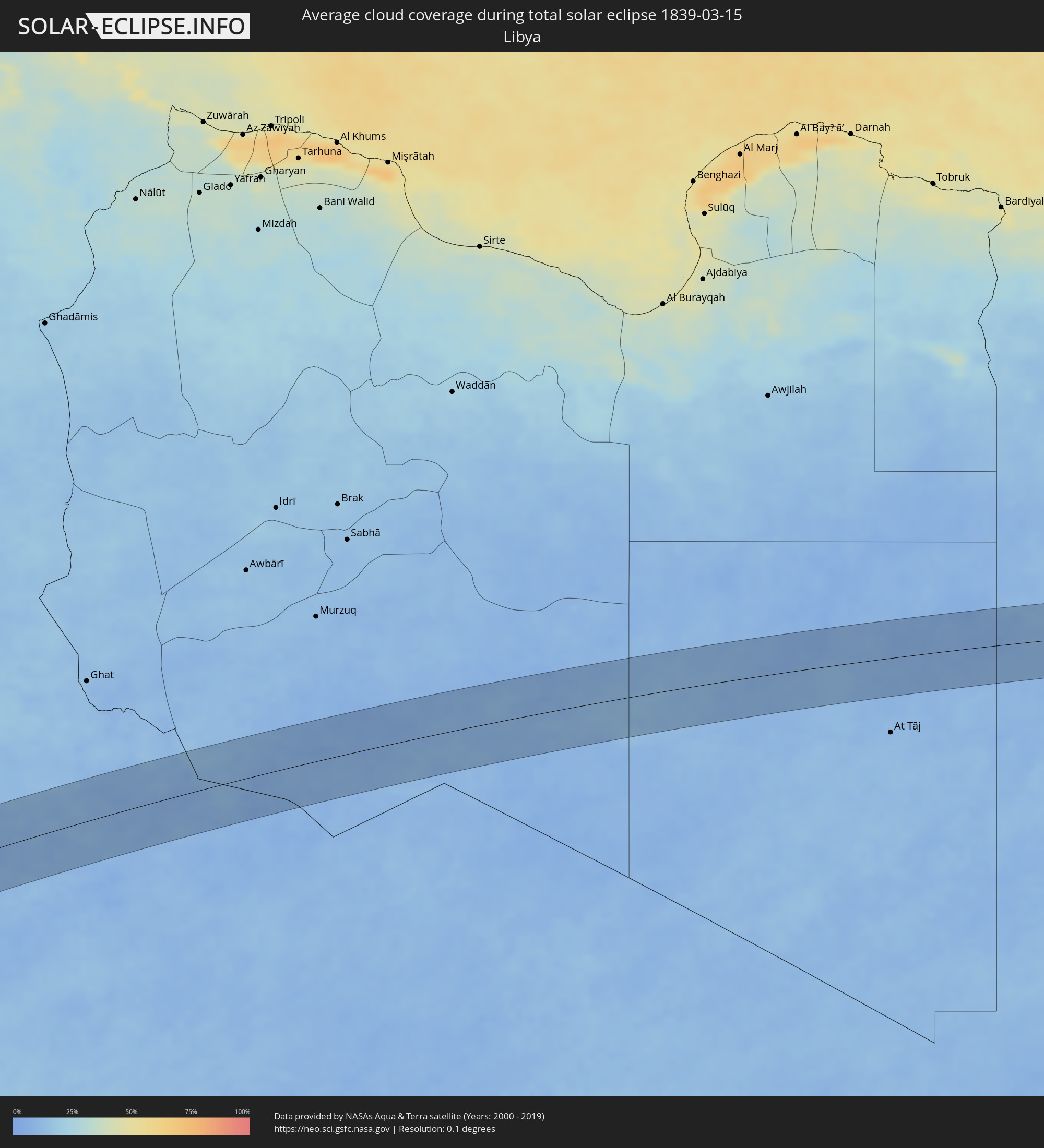 Libya
Libya
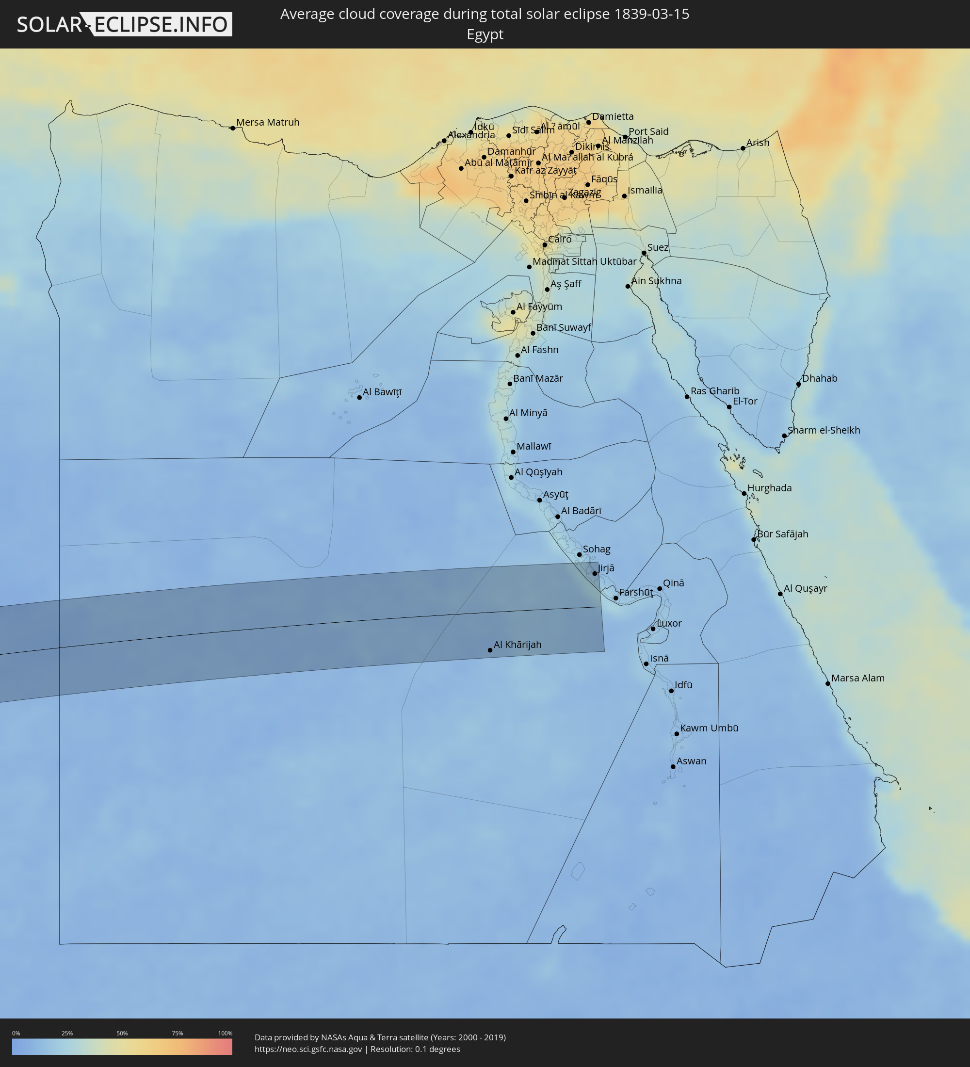 Egypt
Egypt
Cities inside the path of the eclipse
The following table shows all locations with a population of more than 5,000 inside the eclipse path. Cities which have more than 100,000 inhabitants are marked bold. A click at the locations opens a detailed map.
| City | Type | Eclipse duration | Local time of max. eclipse | Distance to central line | Ø Cloud coverage |
|
Ovalle, Coquimbo
|
total | - | 07:56:10 UTC-04:42 | 11 km | 14% |
|
Monte Patria, Coquimbo
|
total | - | 07:56:20 UTC-04:42 | 4 km | 6% |
|
Vicuña, Coquimbo
|
total | - | 07:56:40 UTC-04:42 | 63 km | 4% |
|
San José de Jáchal, San Juan Province
|
total | - | 08:24:05 UTC-04:16 | 5 km | 27% |
|
La Rioja, La Rioja Province
|
total | - | 08:25:55 UTC-04:16 | 37 km | 48% |
|
Icaño, Catamarca Province
|
total | - | 08:27:28 UTC-04:16 | 47 km | 54% |
|
Recreo, Catamarca Province
|
total | - | 08:27:34 UTC-04:16 | 0 km | 54% |
|
Villa Ojo de Agua, Santiago del Estero Province
|
total | - | 08:28:45 UTC-04:16 | 64 km | 52% |
|
Añatuya, Santiago del Estero Province
|
total | - | 08:30:05 UTC-04:16 | 19 km | 55% |
|
Hermoso Campo, Chaco Province
|
total | - | 08:32:05 UTC-04:16 | 58 km | 51% |
|
Santa Sylvina, Chaco Province
|
total | - | 08:32:10 UTC-04:16 | 27 km | 53% |
|
Coronel Du Graty, Chaco Province
|
total | - | 08:32:30 UTC-04:16 | 35 km | 50% |
|
Villa Ángela, Chaco Province
|
total | - | 08:32:46 UTC-04:16 | 39 km | 50% |
|
San Bernardo, Chaco Province
|
total | - | 08:32:57 UTC-04:16 | 69 km | 50% |
|
Villa Berthet, Chaco Province
|
total | - | 08:33:17 UTC-04:16 | 57 km | 46% |
|
Presidencia de la Plaza, Chaco Province
|
total | - | 08:34:06 UTC-04:16 | 66 km | 44% |
|
Puerto Tirol, Chaco Province
|
total | - | 08:34:42 UTC-04:16 | 1 km | 45% |
|
Fontana, Chaco Province
|
total | - | 08:34:44 UTC-04:16 | 8 km | 46% |
|
Resistencia, Chaco Province
|
total | - | 08:34:45 UTC-04:16 | 13 km | 43% |
|
Puerto Vilelas, Chaco Province
|
total | - | 08:34:46 UTC-04:16 | 21 km | 43% |
|
La Leonesa, Chaco Province
|
total | - | 08:35:21 UTC-04:16 | 19 km | 49% |
|
Paso de la Patria, Corrientes Province
|
total | - | 08:35:19 UTC-04:16 | 15 km | 44% |
|
San Luis del Palmar, Corrientes Province
|
total | - | 08:35:13 UTC-04:16 | 35 km | 44% |
|
Pilar, Ñeembucú
|
total | - | 09:02:05 UTC-03:50 | 20 km | 49% |
|
Itatí, Corrientes Province
|
total | - | 08:35:44 UTC-04:16 | 23 km | 43% |
|
Quiindy, Paraguarí
|
total | - | 09:03:58 UTC-03:50 | 70 km | 55% |
|
San Juan Bautista, Misiones
|
total | - | 09:03:35 UTC-03:50 | 6 km | 54% |
|
Santa Rosa, Misiones
|
total | - | 09:03:47 UTC-03:50 | 38 km | 54% |
|
Villarrica, Guairá
|
total | - | 09:05:09 UTC-03:50 | 57 km | 53% |
|
Caazapá, Caazapá
|
total | - | 09:04:53 UTC-03:50 | 9 km | 53% |
|
San Pedro del Paraná, Itapúa
|
total | - | 09:04:36 UTC-03:50 | 62 km | 52% |
|
Caaguazú, Caaguazú
|
total | - | 09:05:55 UTC-03:50 | 69 km | 54% |
|
San Juan Nepomuceno, Caazapá
|
total | - | 09:05:27 UTC-03:50 | 2 km | 52% |
|
Repatriación, Caaguazú
|
total | - | 09:05:56 UTC-03:50 | 58 km | 54% |
|
Colonia General Alfredo Stroessner, Caaguazú
|
total | - | 09:06:24 UTC-03:50 | 63 km | 58% |
|
Doctor Juan León Mallorquín, Alto Paraná
|
total | - | 09:06:55 UTC-03:50 | 41 km | 55% |
|
Arquitecto Tomás Romero Pereira, Itapúa
|
total | - | 09:06:02 UTC-03:50 | 68 km | 58% |
|
Santa Rita, Alto Paraná
|
total | - | 09:06:51 UTC-03:50 | 6 km | 57% |
|
Puerto Esperanza, Misiones Province
|
total | - | 08:41:01 UTC-04:16 | 47 km | 51% |
|
Puerto Libertad, Misiones Province
|
total | - | 09:07:18 UTC-03:50 | 40 km | 49% |
|
Presidente Franco, Alto Paraná
|
total | - | 09:07:38 UTC-03:50 | 2 km | 52% |
|
Ciudad del Este, Alto Paraná
|
total | - | 09:07:40 UTC-03:50 | 0 km | 52% |
|
Foz do Iguaçu, Paraná
|
total | - | 09:51:51 UTC-03:06 | 5 km | 52% |
|
Puerto Iguazú, Misiones Province
|
total | - | 08:41:30 UTC-04:16 | 10 km | 51% |
|
Colonia Wanda, Misiones Province
|
total | - | 08:41:22 UTC-04:16 | 54 km | 55% |
|
Toledo, Paraná
|
total | - | 09:53:43 UTC-03:06 | 38 km | 64% |
|
Cascavel, Paraná
|
total | - | 09:53:52 UTC-03:06 | 1 km | 64% |
|
Maringá, Paraná
|
total | - | 09:57:28 UTC-03:06 | 75 km | 68% |
|
Apucarana, Paraná
|
total | - | 09:58:00 UTC-03:06 | 38 km | 64% |
|
Londrina, Paraná
|
total | - | 09:58:41 UTC-03:06 | 46 km | 65% |
|
Bauru, São Paulo
|
total | - | 10:02:52 UTC-03:06 | 26 km | 72% |
|
Jaú, São Paulo
|
total | - | 10:03:39 UTC-03:06 | 0 km | 68% |
|
Botucatu, São Paulo
|
total | - | 10:03:07 UTC-03:06 | 62 km | 71% |
|
Araraquara, São Paulo
|
total | - | 10:04:50 UTC-03:06 | 24 km | 73% |
|
São Carlos, São Paulo
|
total | - | 10:04:59 UTC-03:06 | 13 km | 75% |
|
Ribeirão Preto, São Paulo
|
total | - | 10:06:10 UTC-03:06 | 60 km | 76% |
|
Rio Claro, São Paulo
|
total | - | 10:05:00 UTC-03:06 | 68 km | 74% |
|
Araras, São Paulo
|
total | - | 10:05:20 UTC-03:06 | 73 km | 71% |
|
Poços de Caldas, Minas Gerais
|
total | - | 10:07:19 UTC-03:06 | 70 km | 80% |
|
Divinópolis, Minas Gerais
|
total | - | 10:12:09 UTC-03:06 | 25 km | 79% |
|
Esmeraldas, Minas Gerais
|
total | - | 10:13:38 UTC-03:06 | 28 km | 77% |
|
Sete Lagoas, Minas Gerais
|
total | - | 10:14:10 UTC-03:06 | 6 km | 79% |
|
Betim, Minas Gerais
|
total | - | 10:13:31 UTC-03:06 | 53 km | 75% |
|
Ribeirão das Neves, Minas Gerais
|
total | - | 10:13:59 UTC-03:06 | 43 km | 81% |
|
Ibirité, Minas Gerais
|
total | - | 10:13:40 UTC-03:06 | 67 km | 79% |
|
Belo Horizonte, Minas Gerais
|
total | - | 10:14:01 UTC-03:06 | 66 km | 83% |
|
Santa Luzia, Minas Gerais
|
total | - | 10:14:22 UTC-03:06 | 58 km | 79% |
|
Itabuna, Bahia
|
total | - | 11:02:41 UTC-02:34 | 44 km | 83% |
|
Ilhéus, Bahia
|
total | - | 11:03:06 UTC-02:34 | 25 km | 61% |
|
Kamsar, Boke
|
total | - | 14:53:44 UTC-00:16 | 19 km | 34% |
|
Sanguéya, Boke
|
total | - | 14:54:08 UTC-00:16 | 5 km | 26% |
|
Boké, Boke
|
total | - | 14:54:37 UTC-00:16 | 20 km | 23% |
|
Fria, Boke
|
total | - | 14:54:47 UTC-00:16 | 78 km | 30% |
|
Kimbo, Boke
|
total | - | 14:54:53 UTC-00:16 | 77 km | 30% |
|
Gaoual, Boke
|
total | - | 14:57:31 UTC-00:16 | 16 km | 17% |
|
Youkounkoun, Boke
|
total | - | 14:58:48 UTC-00:16 | 79 km | 13% |
|
Télimélé, Kindia
|
total | - | 14:56:26 UTC-00:16 | 69 km | 19% |
|
Mali, Labe
|
total | - | 14:59:19 UTC-00:16 | 15 km | 15% |
|
Kédougou, Kédougou
|
total | - | 15:00:12 UTC-00:16 | 19 km | 11% |
|
Bafoulabé, Kayes
|
total | - | 15:03:52 UTC-00:16 | 44 km | 13% |
|
Al Khārijah, New Valley
|
total | - | 17:56:53 UTC+02:00 | 50 km | 13% |
|
Jirjā, Sohag
|
total | - | 17:57:02 UTC+02:00 | 42 km | 25% |