Totale Sonnenfinsternis vom 30.06.1954
6 Personen haben diese Sonnenfinsternis beobachtet.
| Wochentag: | Mittwoch |
| Maximale Dauer der Verfinsterung: | 02m35s |
| Maximale Breite des Finsternispfades: | 153 km |
| Saroszyklus: | 126 |
| Bedeckungsgrad: | 100% |
| Magnitude: | 1.0357 |
| Gamma: | 0.6135 |
Wo kann man die Sonnenfinsternis vom 30.06.1954 sehen?
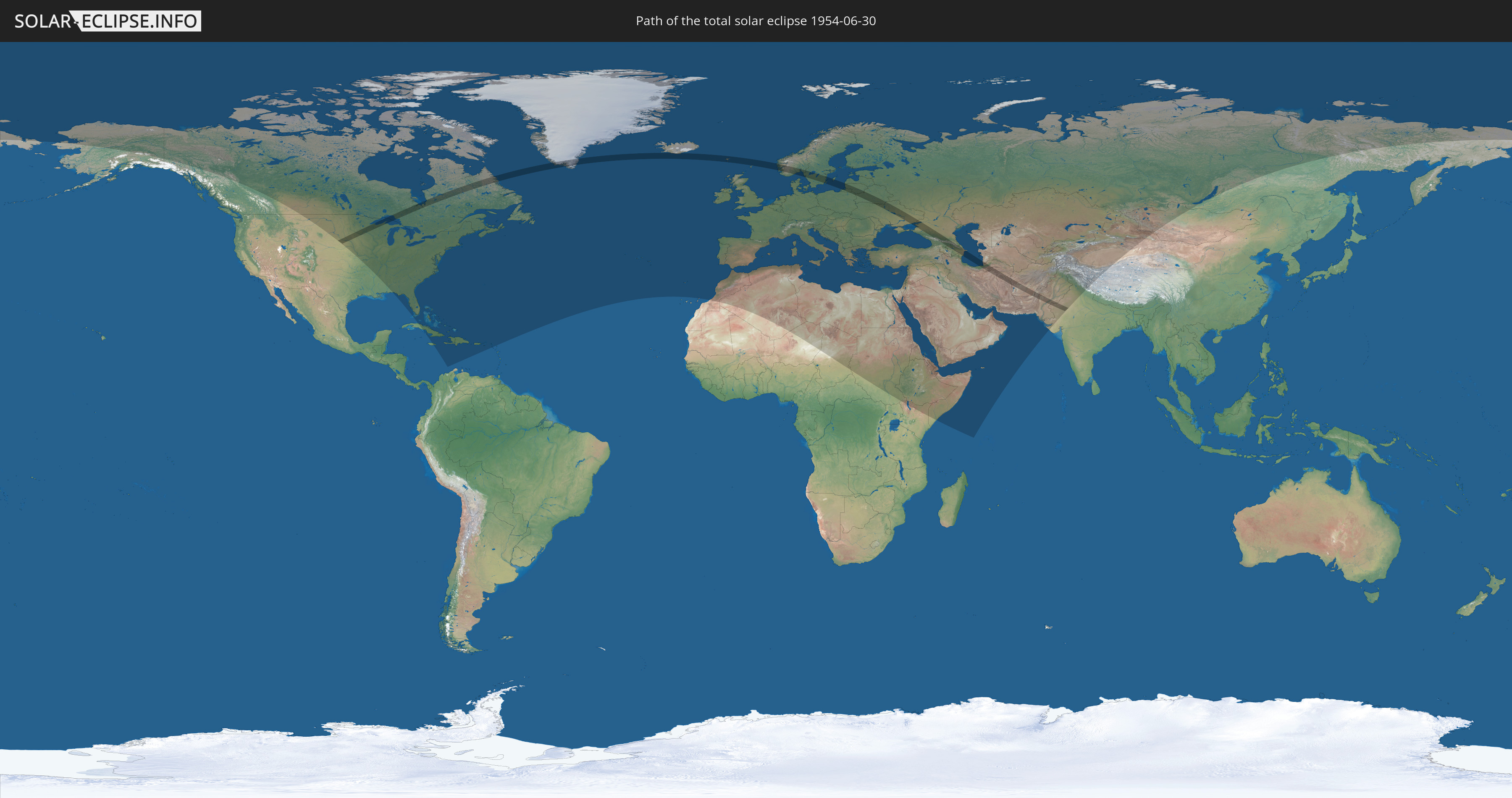
Die Sonnenfinsternis am 30.06.1954 kann man in 112 Ländern als partielle Sonnenfinsternis beobachten.
Der Finsternispfad verläuft durch 21 Länder. Nur in diesen Ländern ist sie als totale Sonnenfinsternis zu sehen.
In den folgenden Ländern ist die Sonnenfinsternis total zu sehen
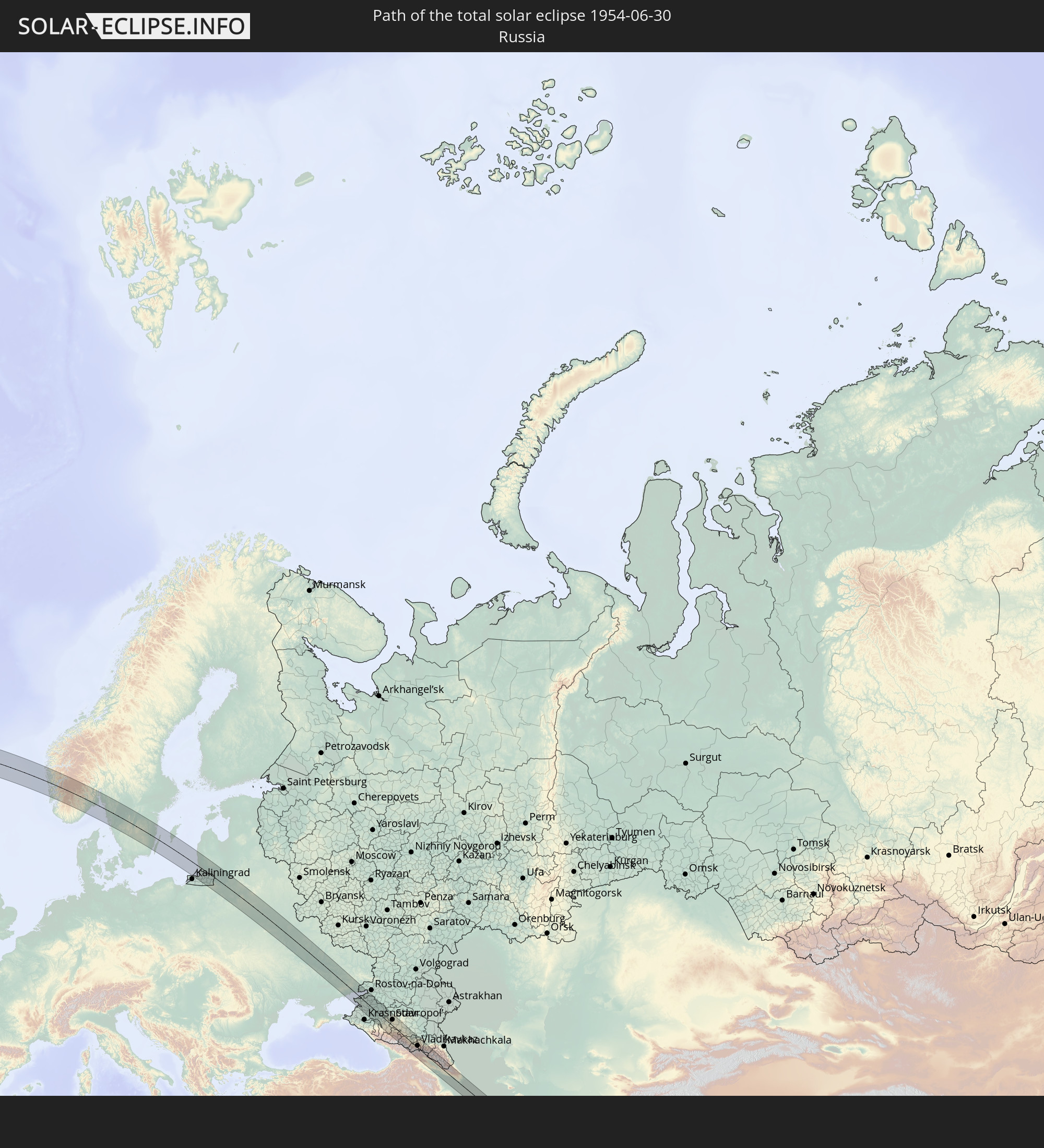 Russland
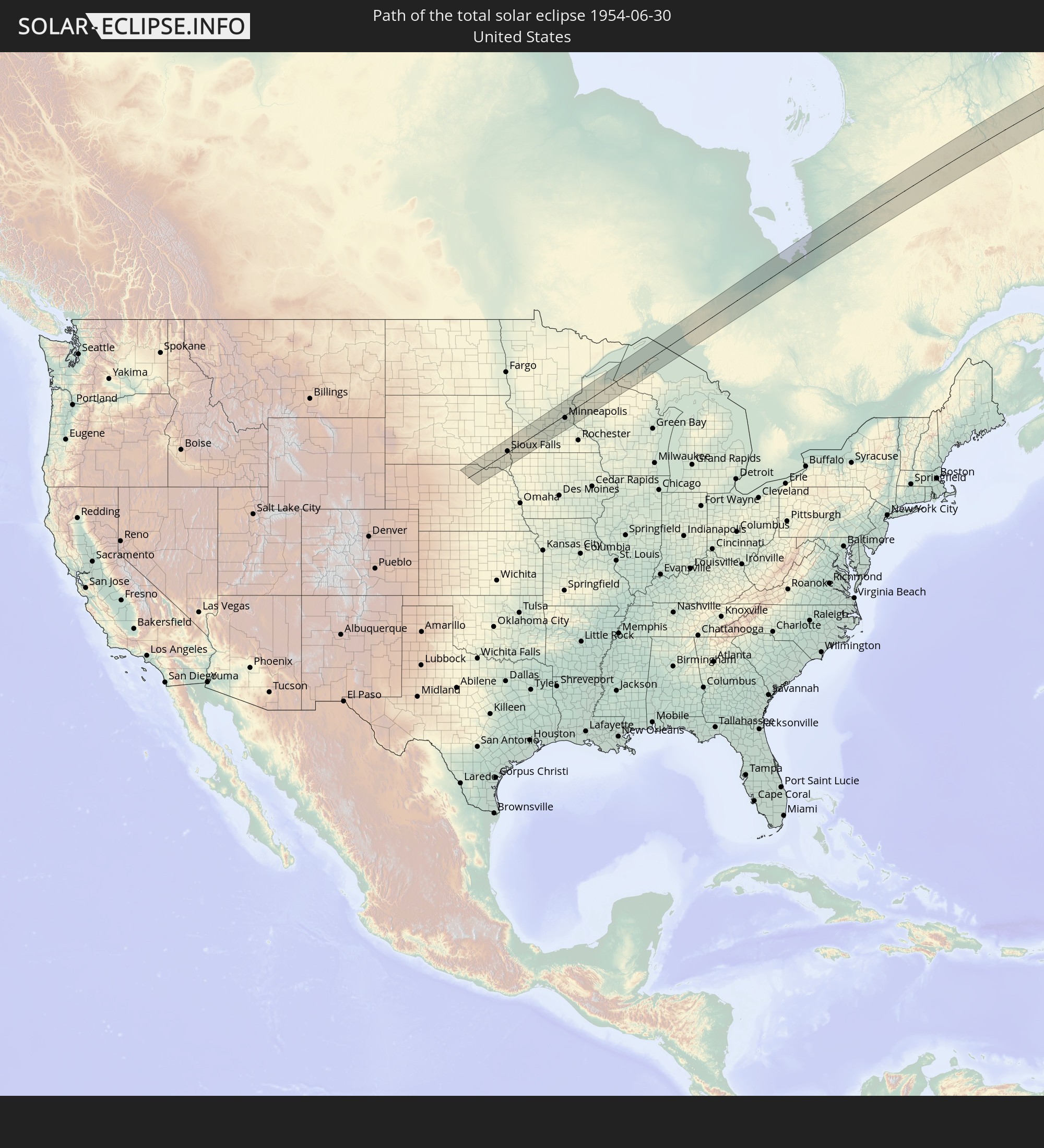 Vereinigte Staaten
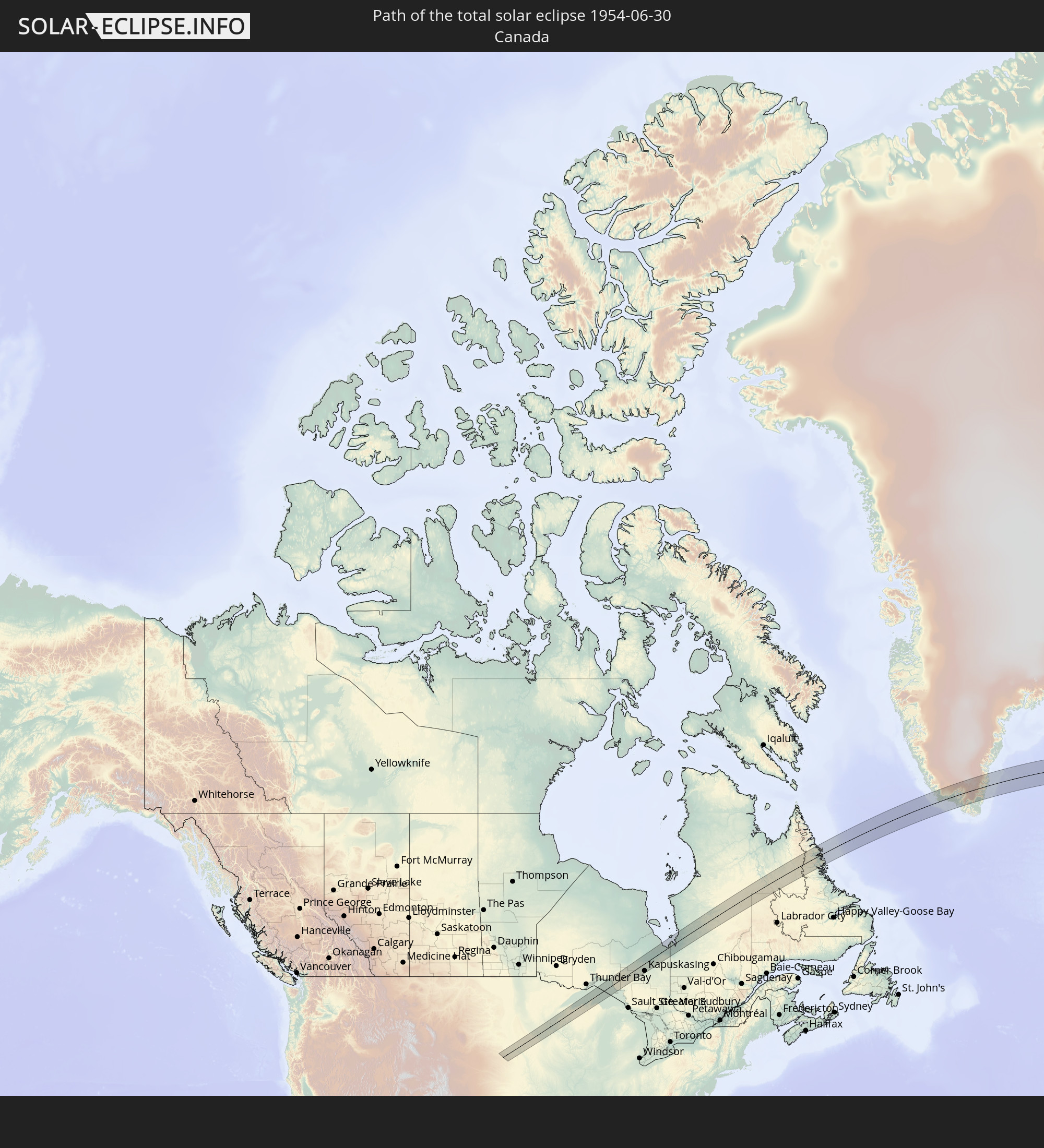 Kanada
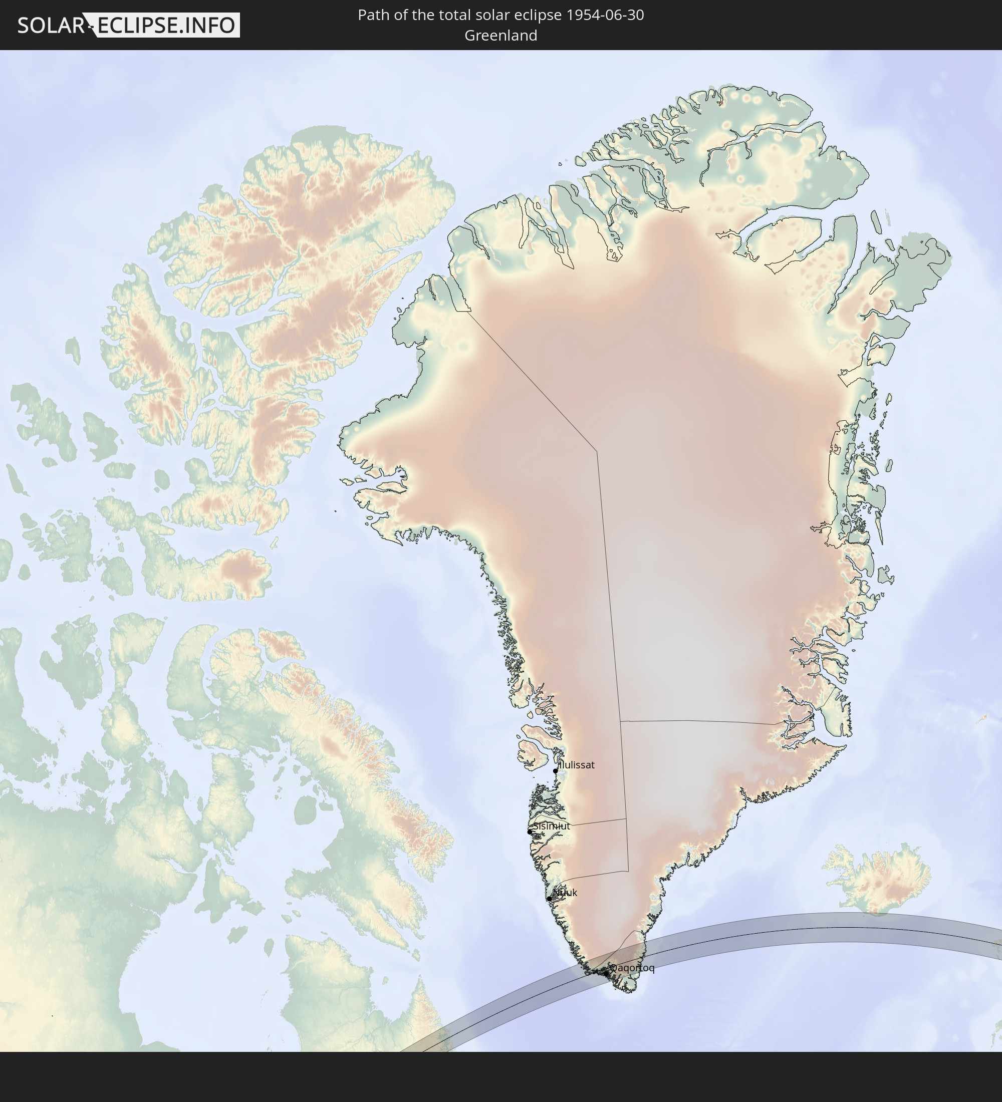 Grönland
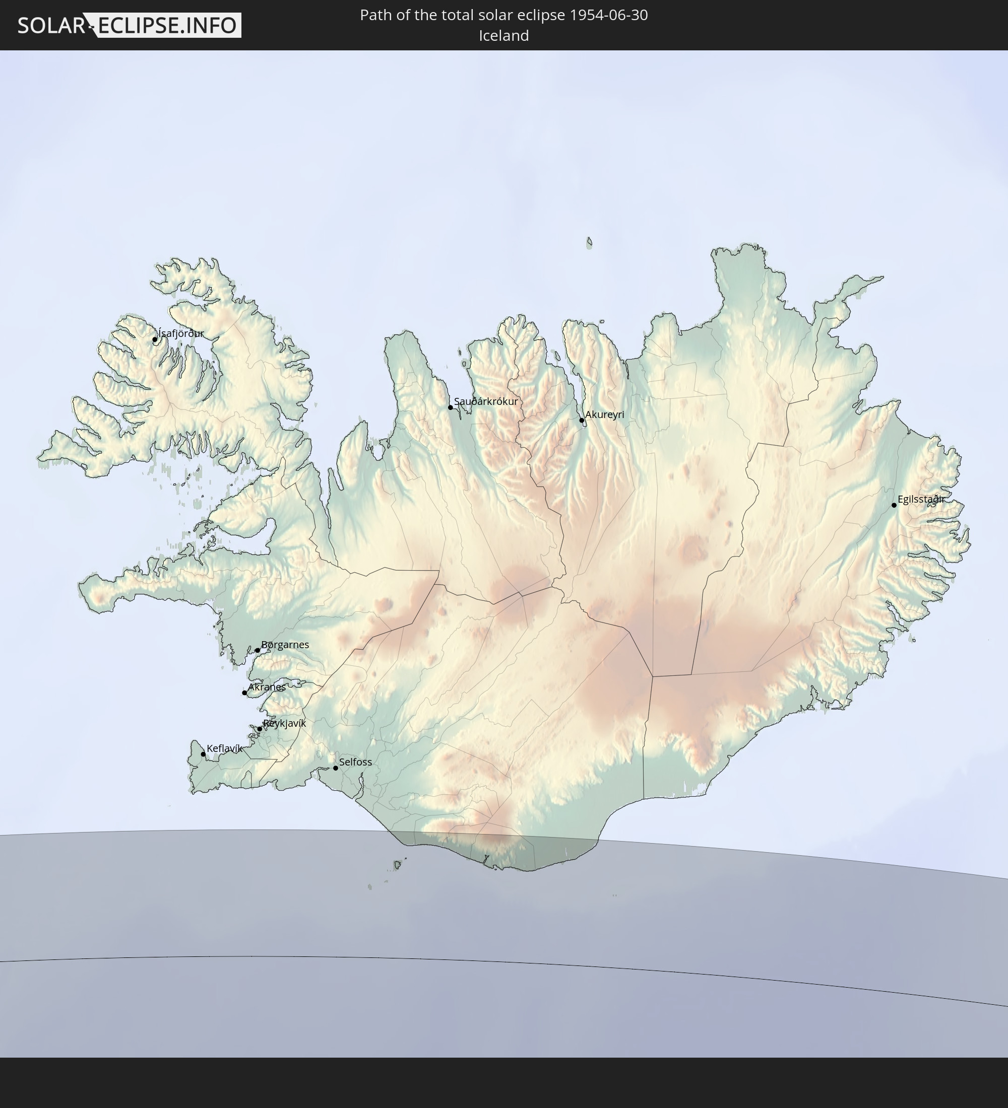 Island
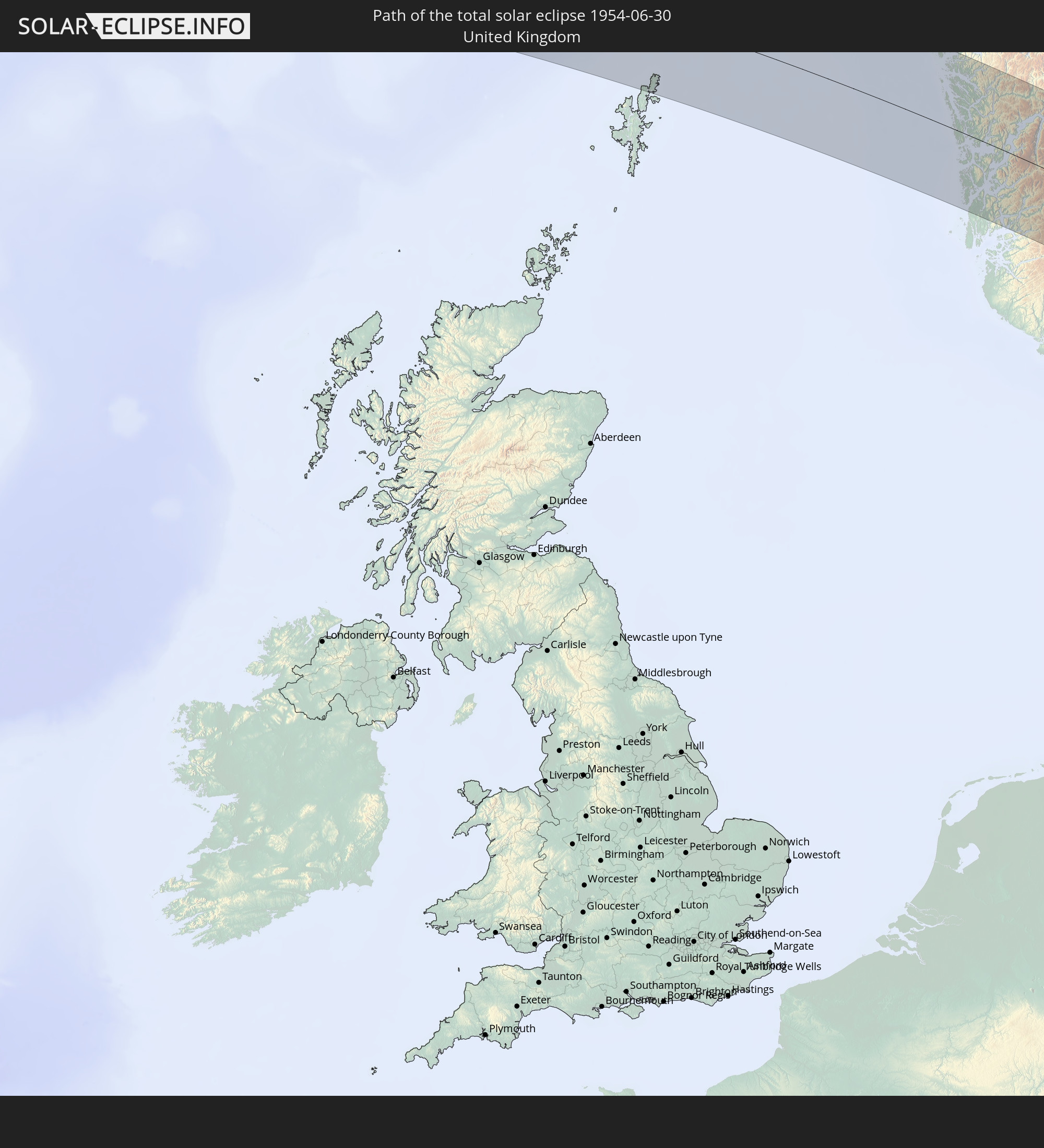 Vereinigtes Königreich
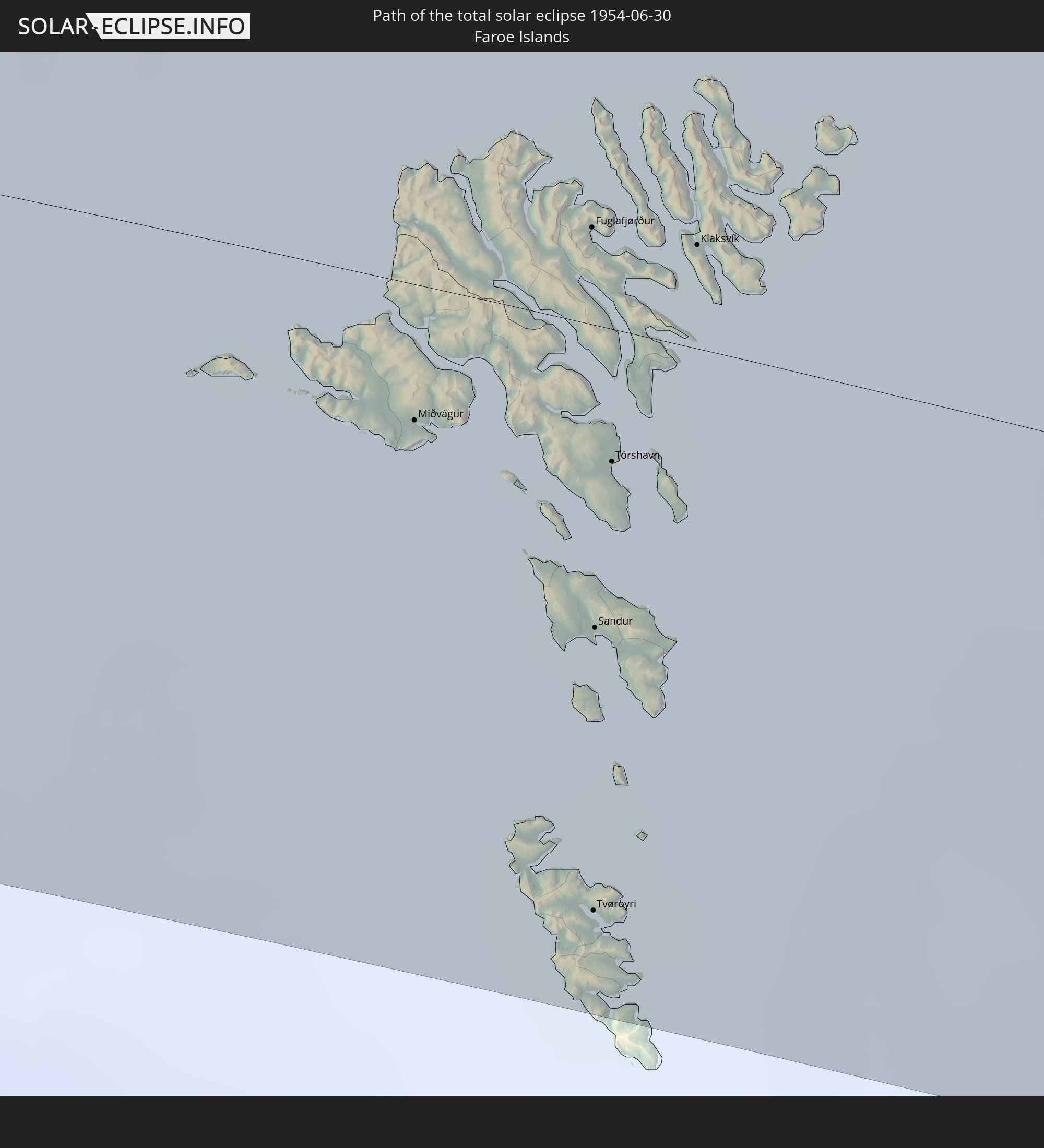 Färöer
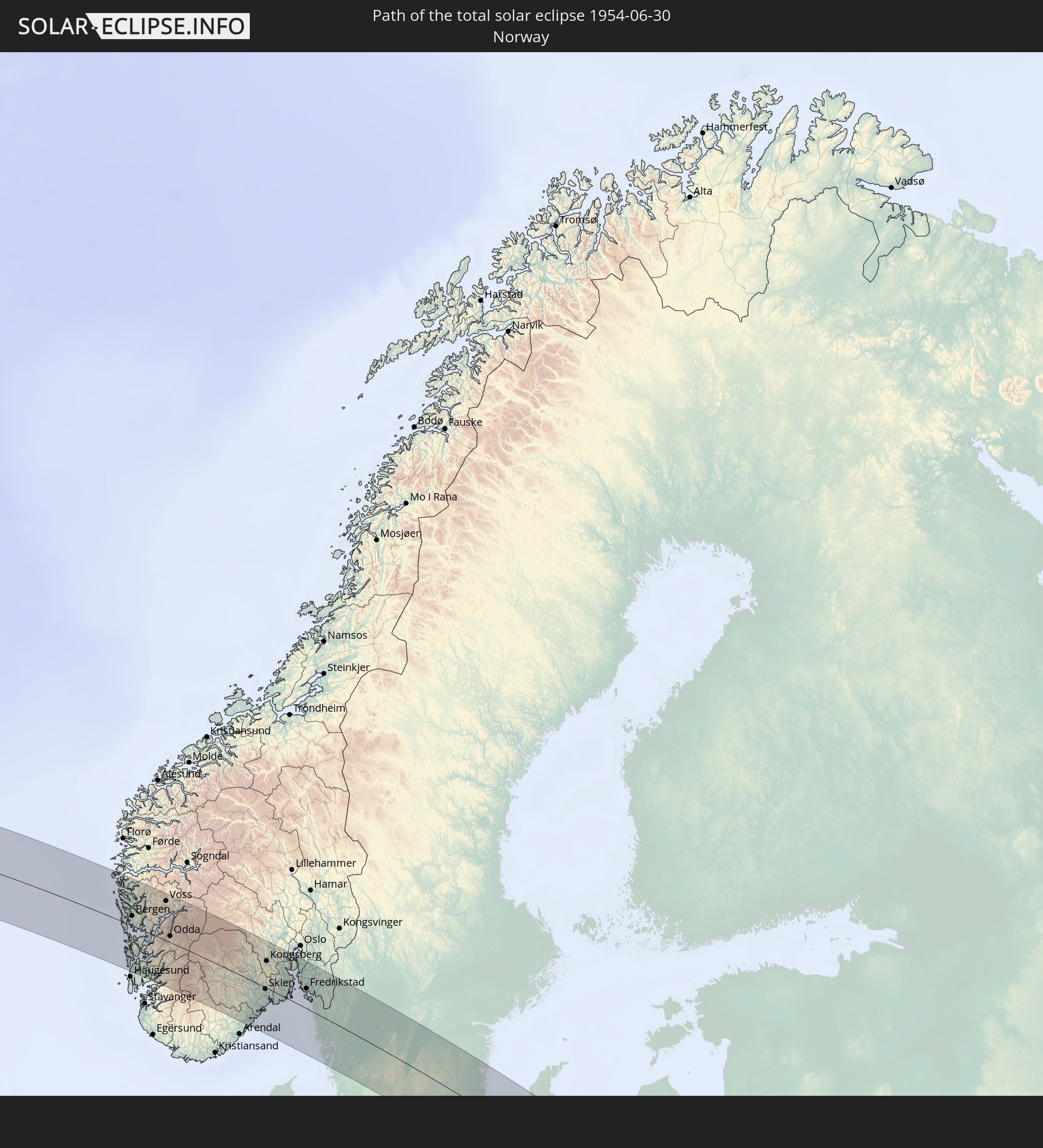 Norwegen
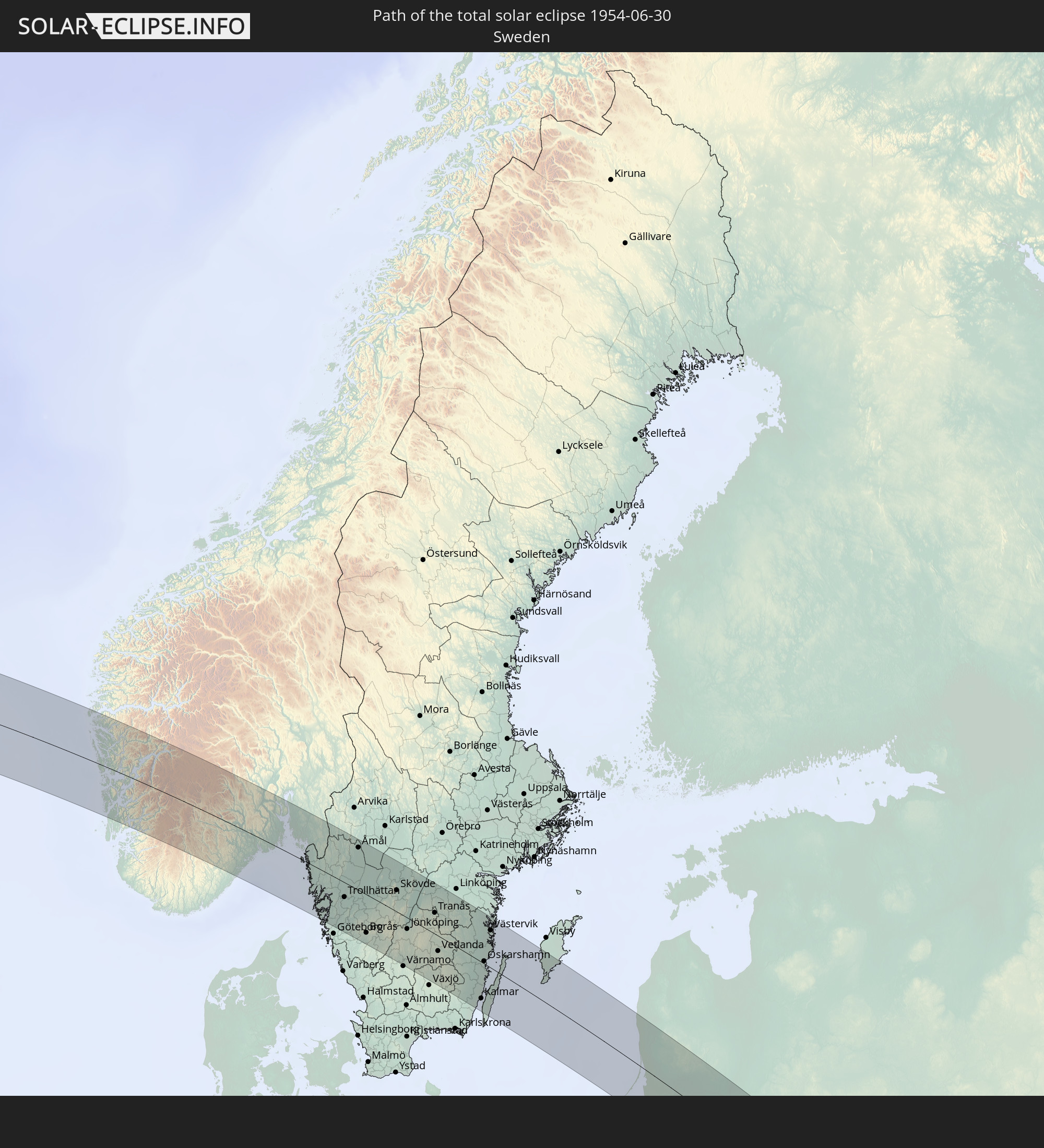 Schweden
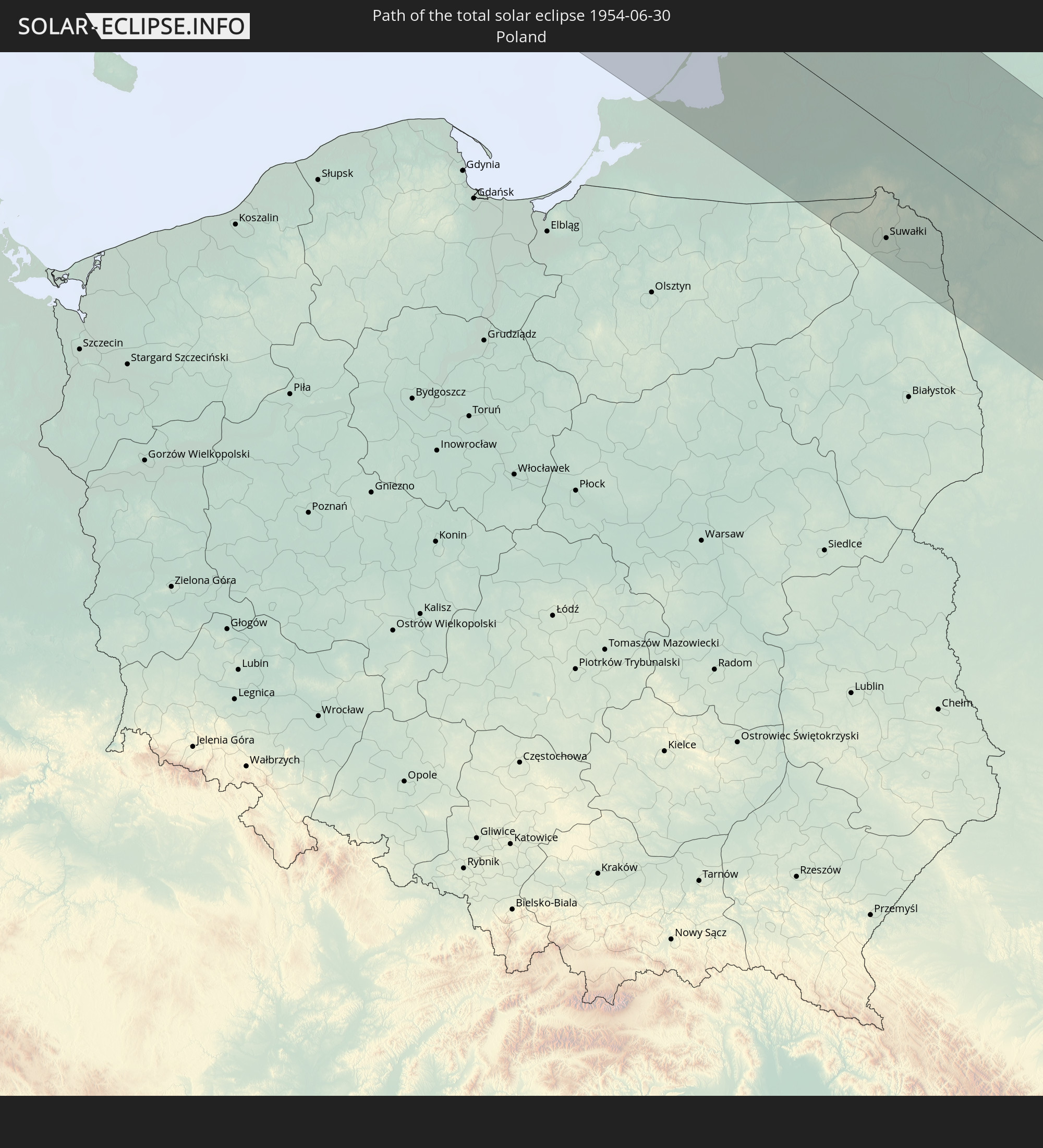 Polen
Polen
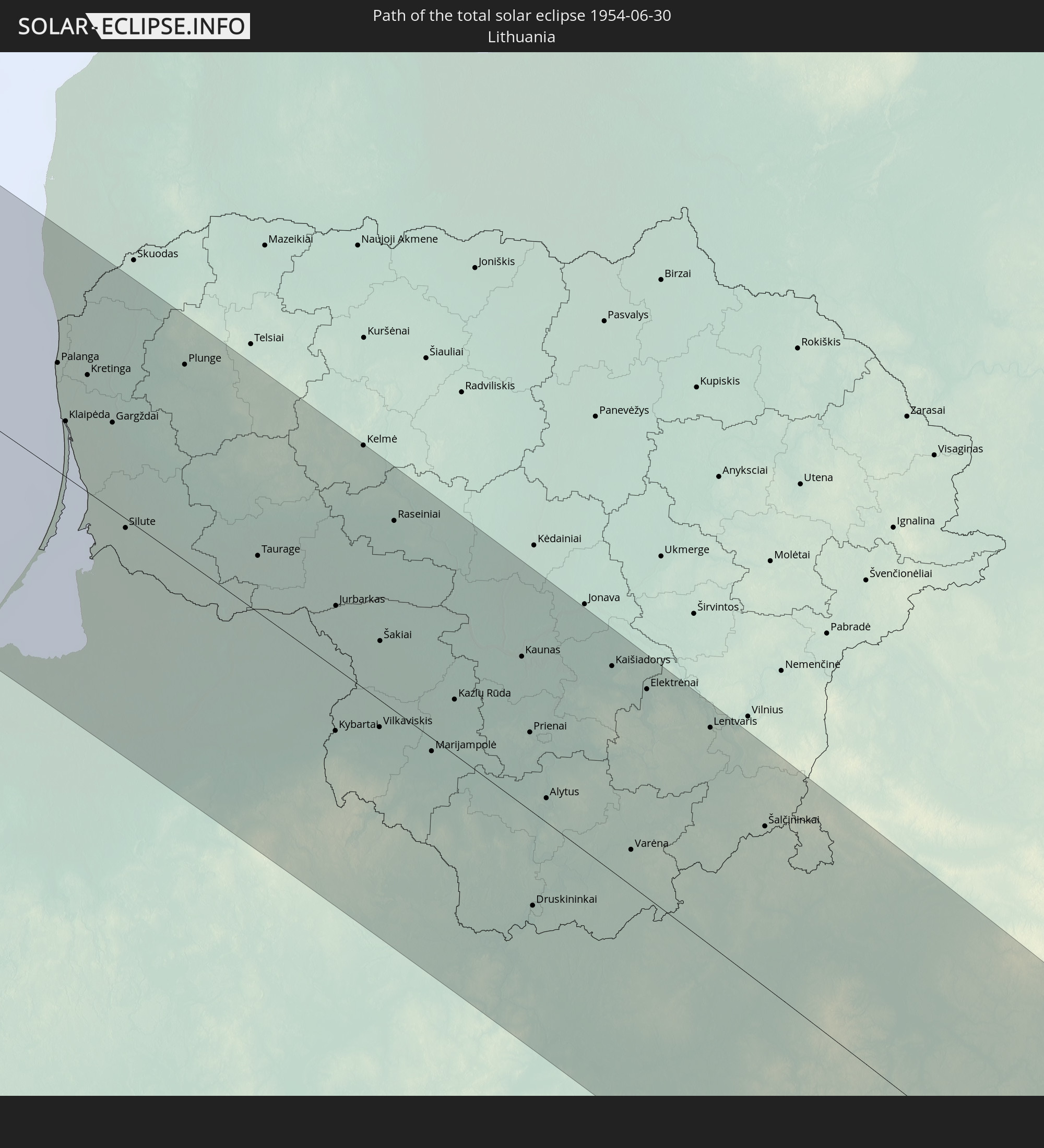 Litauen
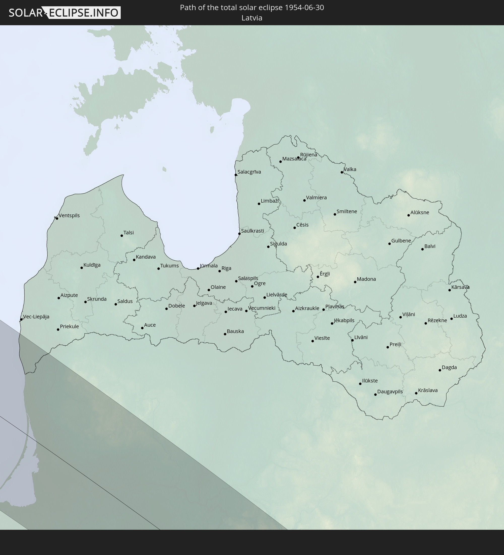 Lettland
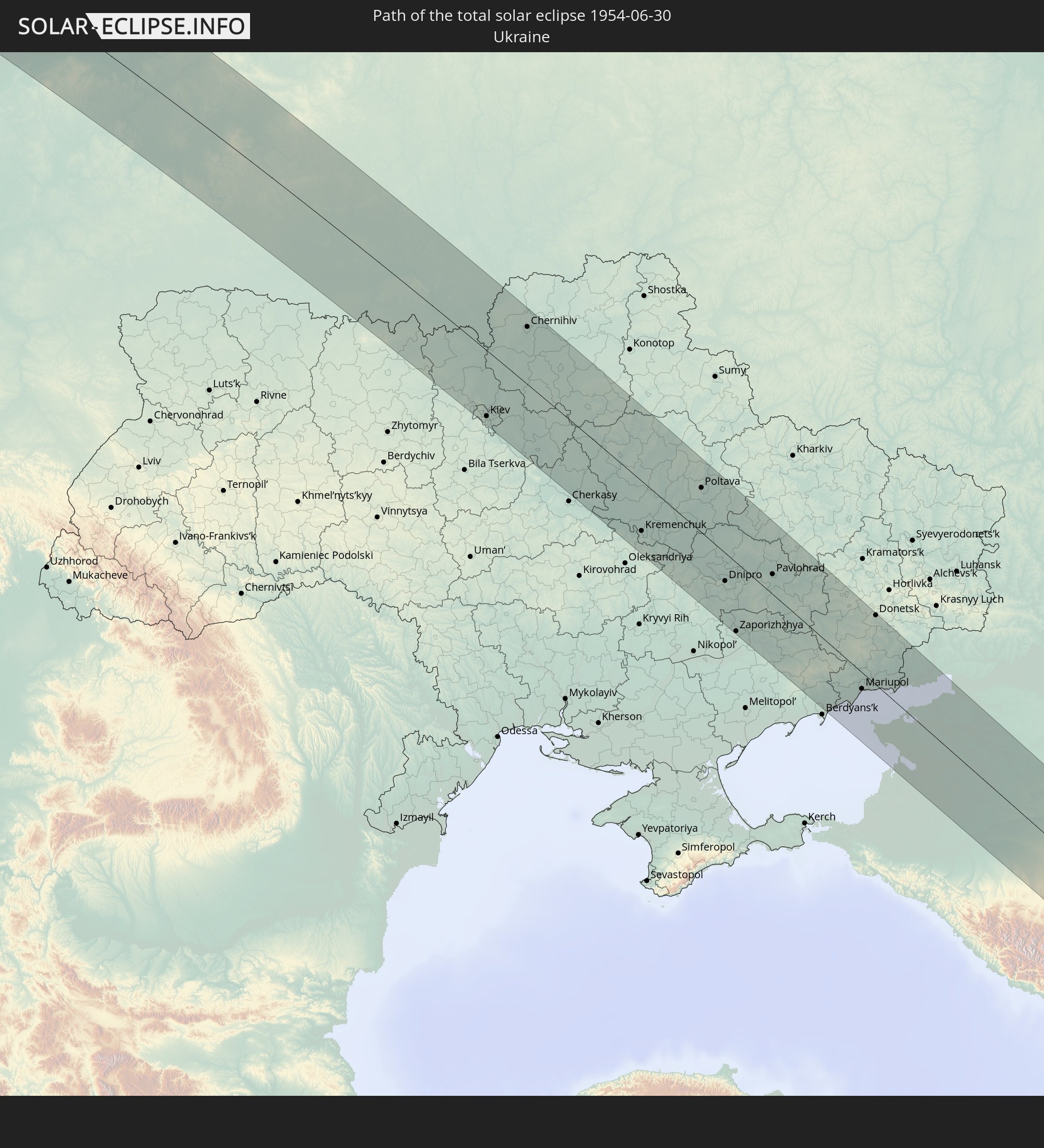 Ukraine
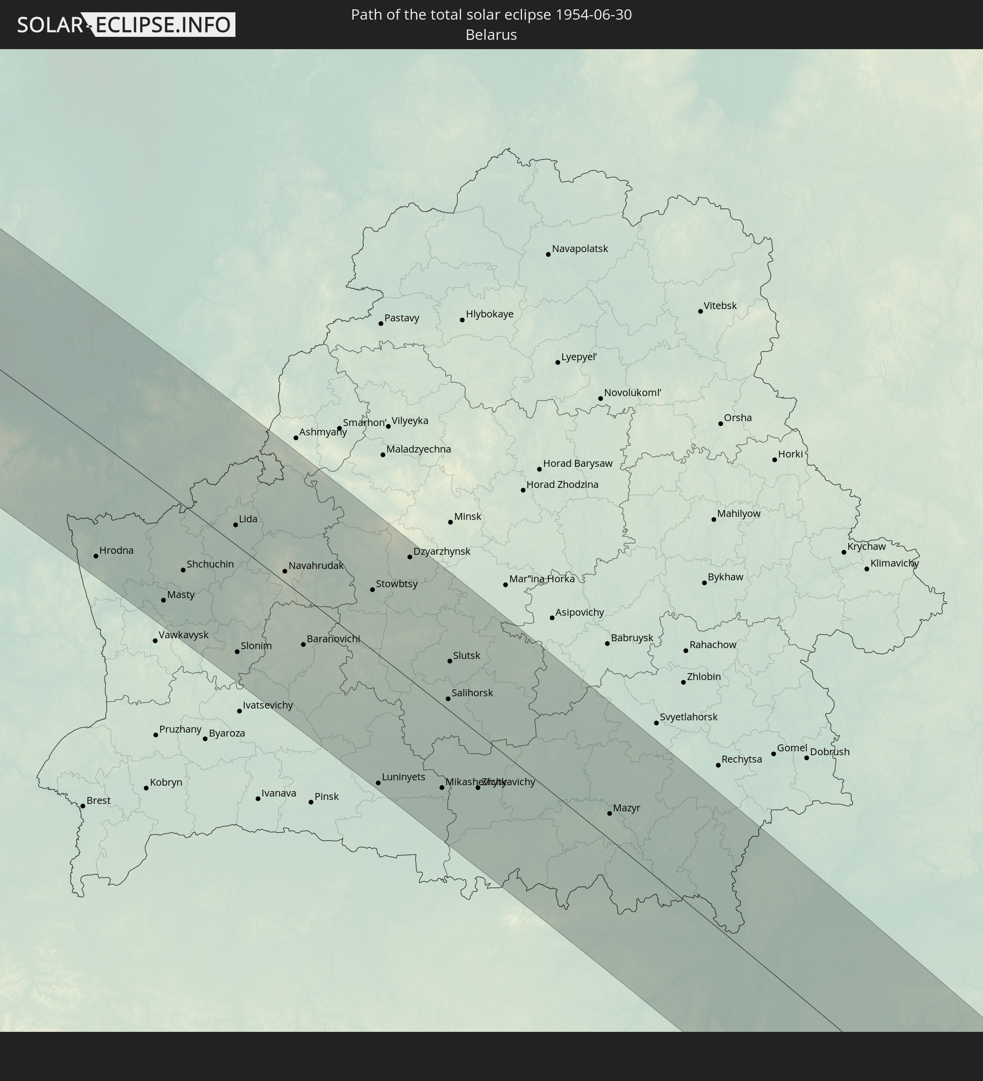 Weißrussland
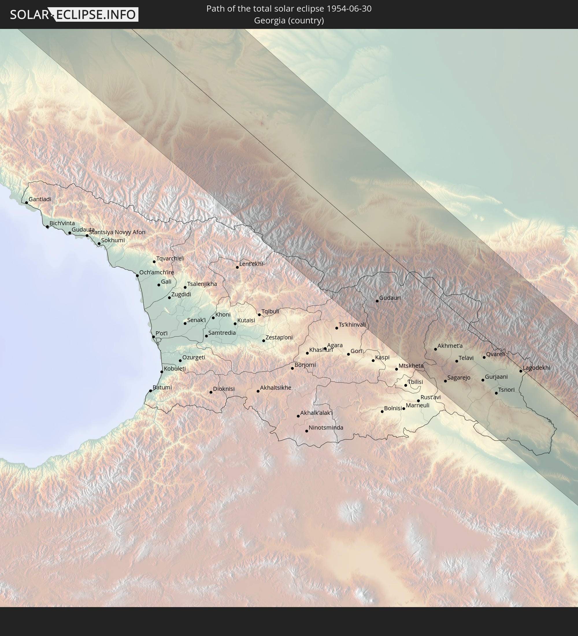 Georgien
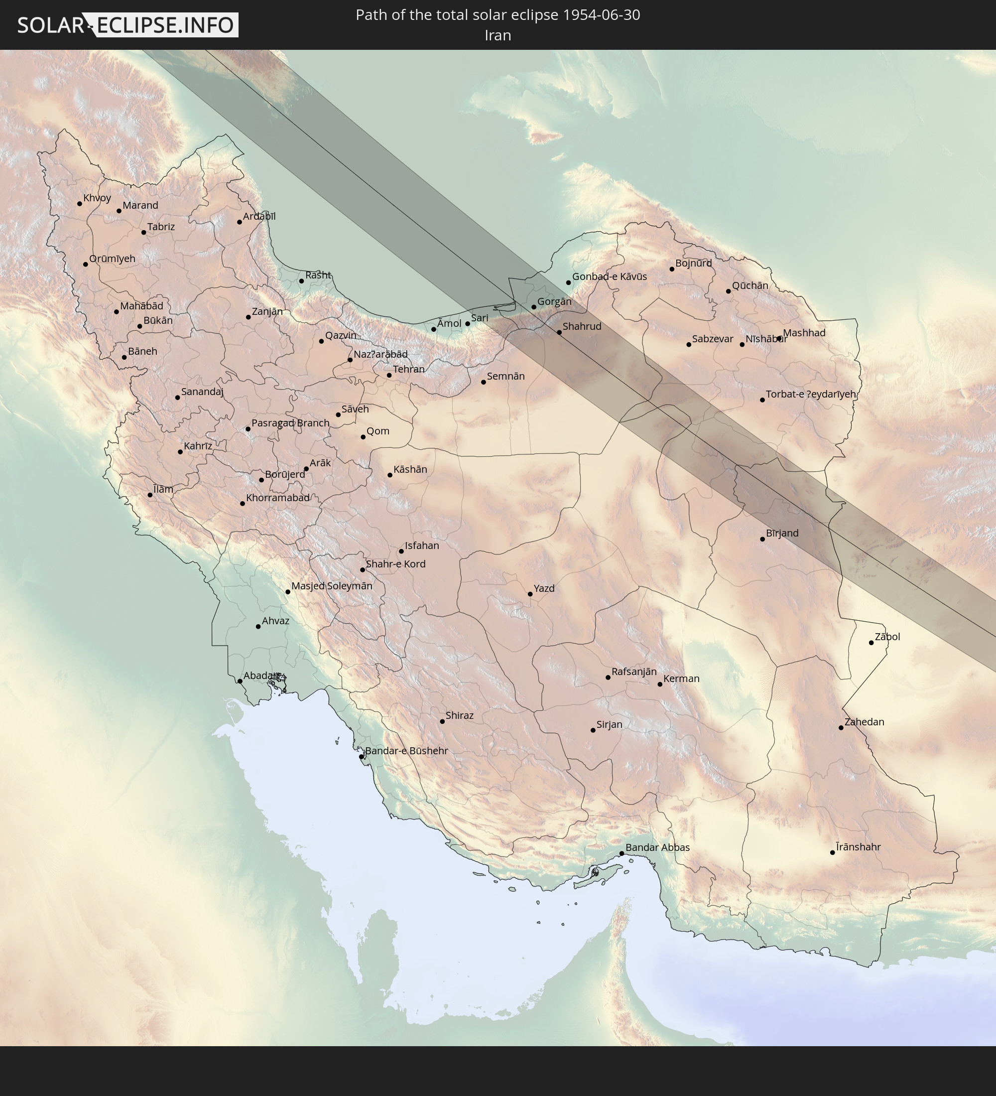 Iran
Iran
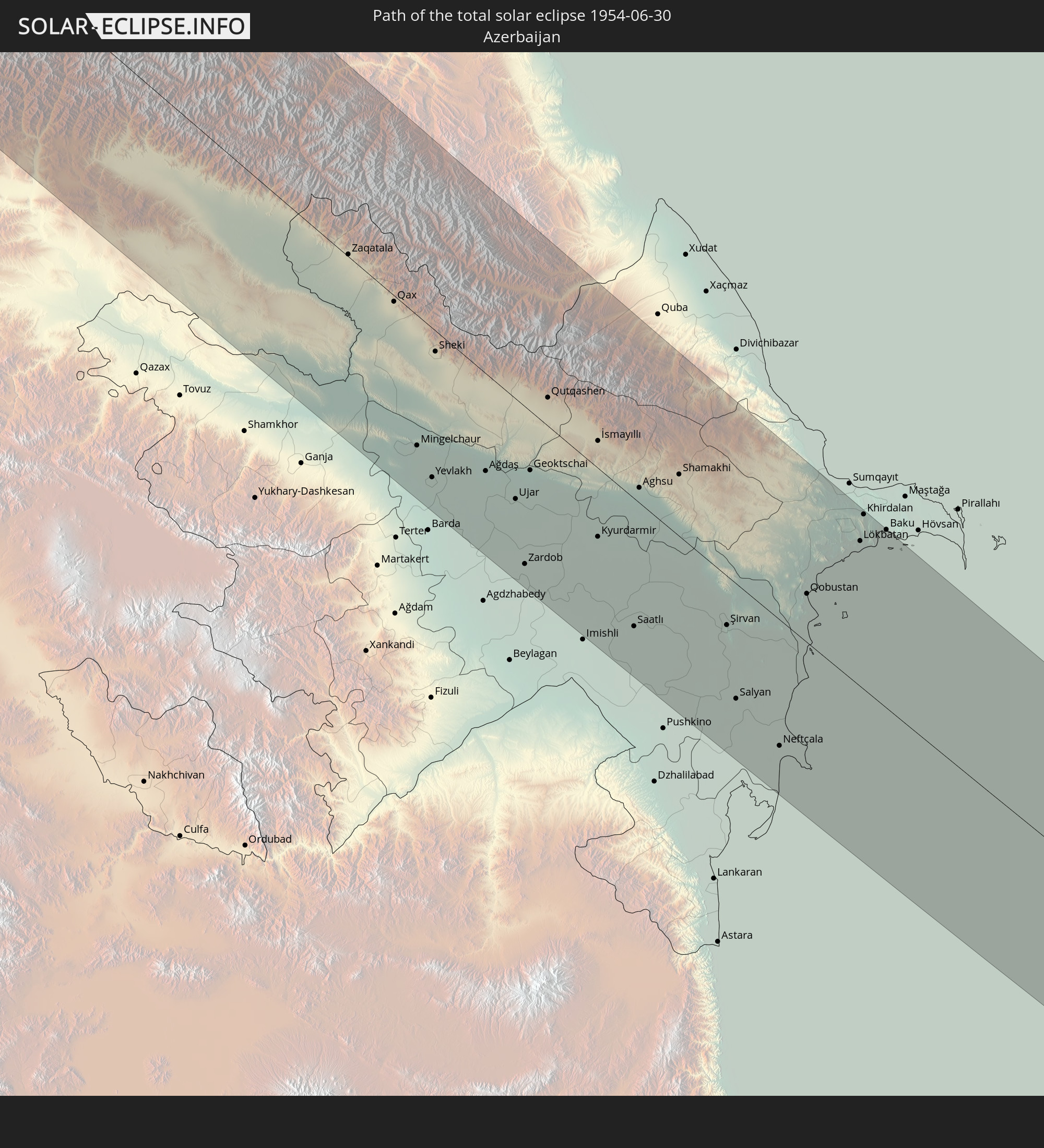 Aserbaidschan
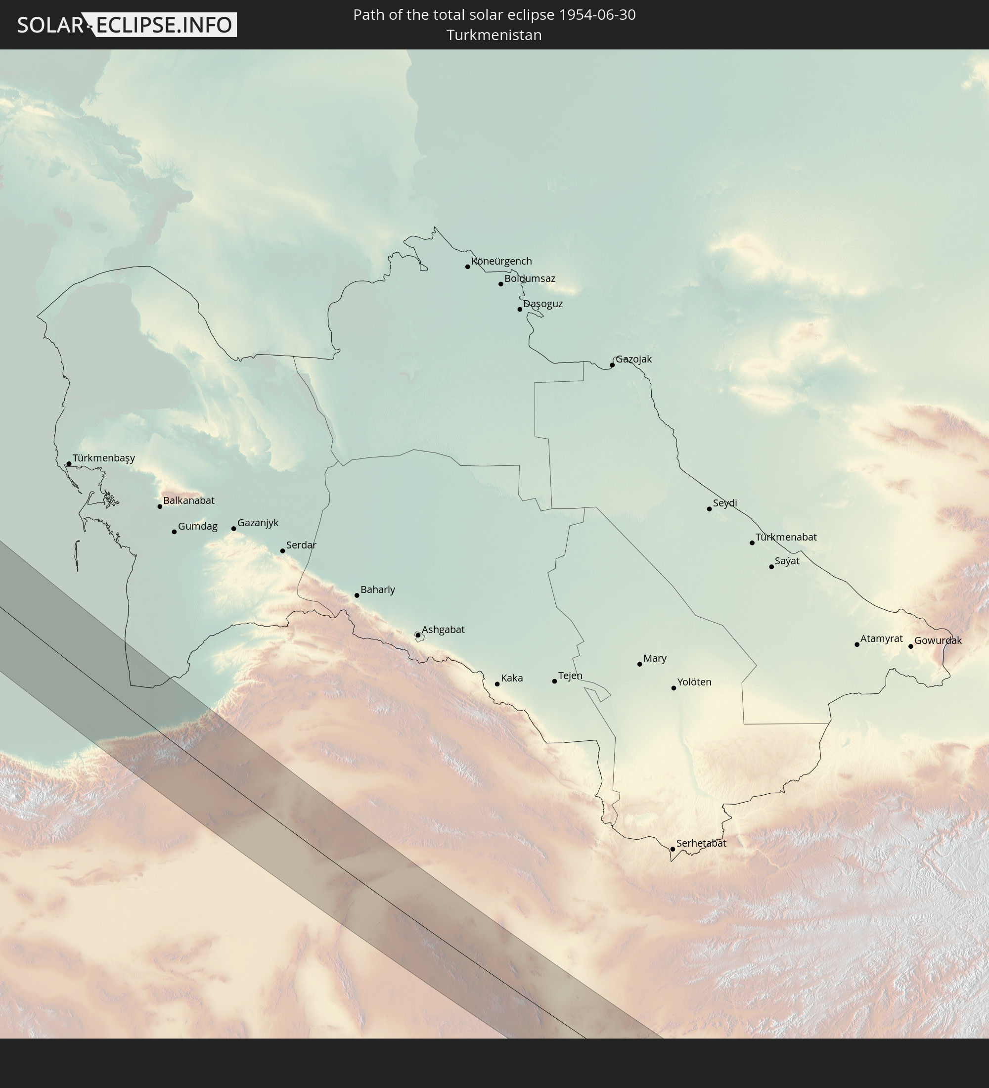 Turkmenistan
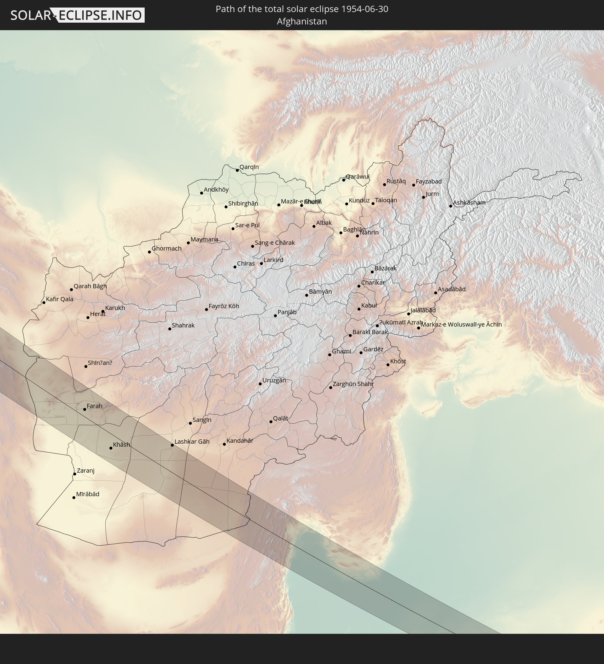 Afghanistan
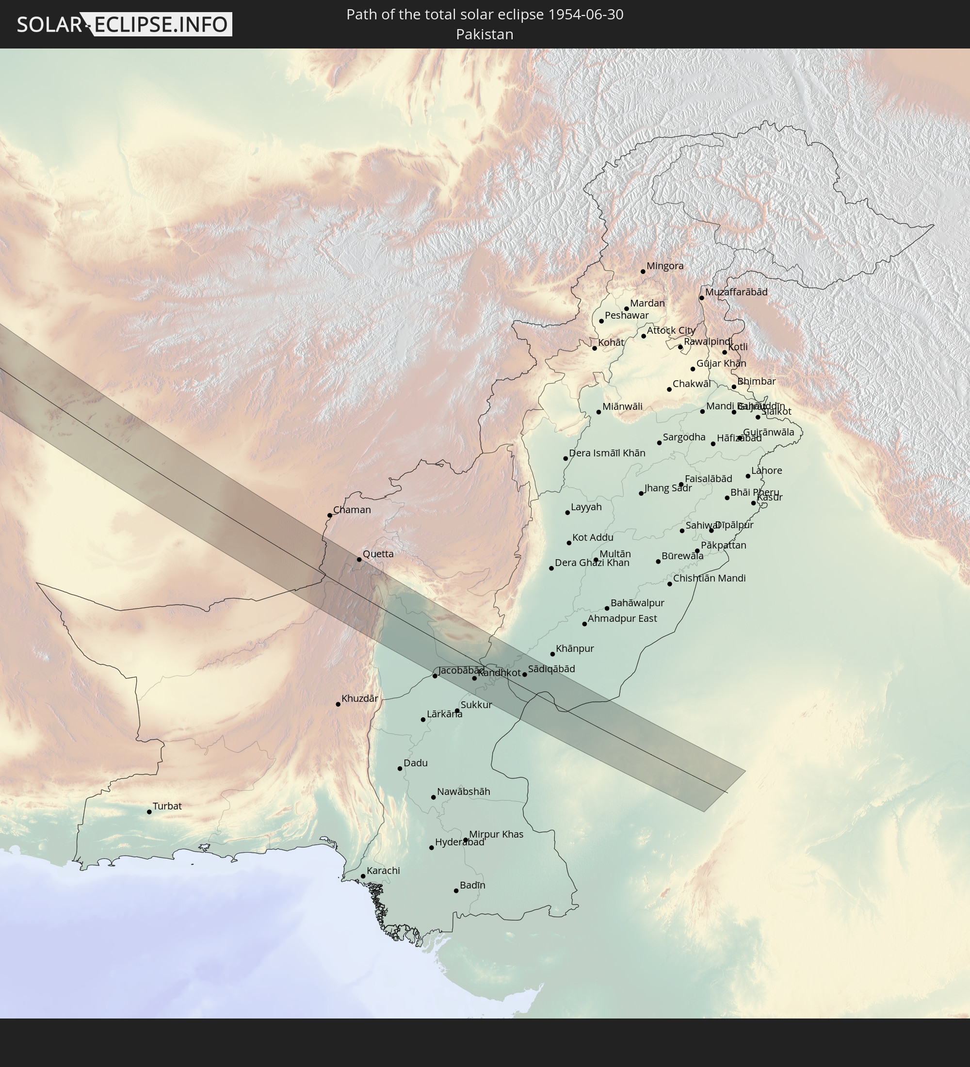 Pakistan
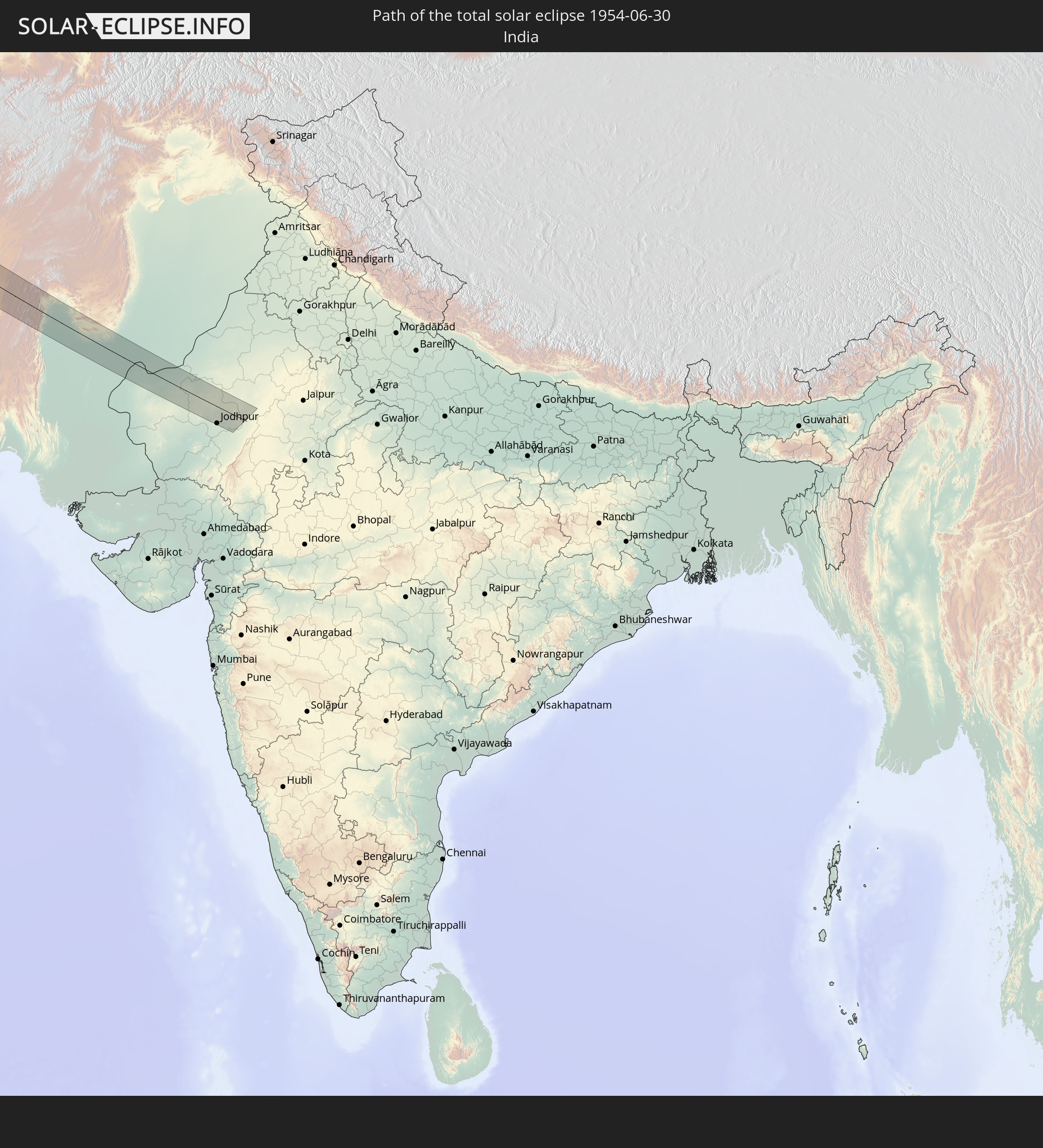 Indien
In den folgenden Ländern ist die Sonnenfinsternis partiell zu sehen
 Russland
 Vereinigte Staaten
 United States Minor Outlying Islands
 Kanada
 Grönland
 Kuba
Kuba
 Bahamas
 Jamaika
 Haiti
Haiti
 Turks- und Caicosinseln
 Dominikanische Republik
 Puerto Rico
 Amerikanische Jungferninseln
 Bermuda
 Britische Jungferninseln
 Anguilla
 Saint-Martin
 Saint-Barthélemy
 St. Kitts und Nevis
 Saint-Pierre und Miquelon
 Portugal
 Island
 Spanien
 Marokko
 Irland
 Spitzbergen
 Algerien
 Vereinigtes Königreich
 Färöer
 Gibraltar
 Frankreich
 Isle of Man
 Guernsey
 Jersey
 Niger
Niger
 Andorra
 Belgien
 Niederlande
 Norwegen
 Luxemburg
 Deutschland
 Schweiz
 Italien
 Monaco
 Tunesien
 Dänemark
 Libyen
 Liechtenstein
 Österreich
 Schweden
 Tschechien
 San Marino
 Vatikanstadt
 Slowenien
 Tschad
 Kroatien
 Polen
Polen
 Malta
Malta
 Bosnien und Herzegowina
 Ungarn
 Slowakei
 Montenegro
 Serbien
 Albanien
 Åland Islands
 Griechenland
 Rumänien
 Mazedonien
 Finnland
 Litauen
 Lettland
 Estland
 Sudan
Sudan
 Ukraine
 Bulgarien
 Weißrussland
 Ägypten
 Türkei
 Moldawien
 Republik Zypern
 Äthiopien
 Kenia
Kenia
 Staat Palästina
 Israel
 Saudi-Arabien
 Jordanien
 Libanon
 Syrien
 Eritrea
 Irak
Irak
 Georgien
 Somalia
 Dschibuti
 Jemen
Jemen
 Armenien
 Iran
Iran
 Aserbaidschan
 Kasachstan
 Kuwait
 Bahrain
 Katar
Katar
 Vereinigte Arabische Emirate
 Oman
Oman
 Turkmenistan
 Usbekistan
 Afghanistan
 Pakistan
 Tadschikistan
 Indien
 Kirgisistan
 Volksrepublik China
 Mongolei
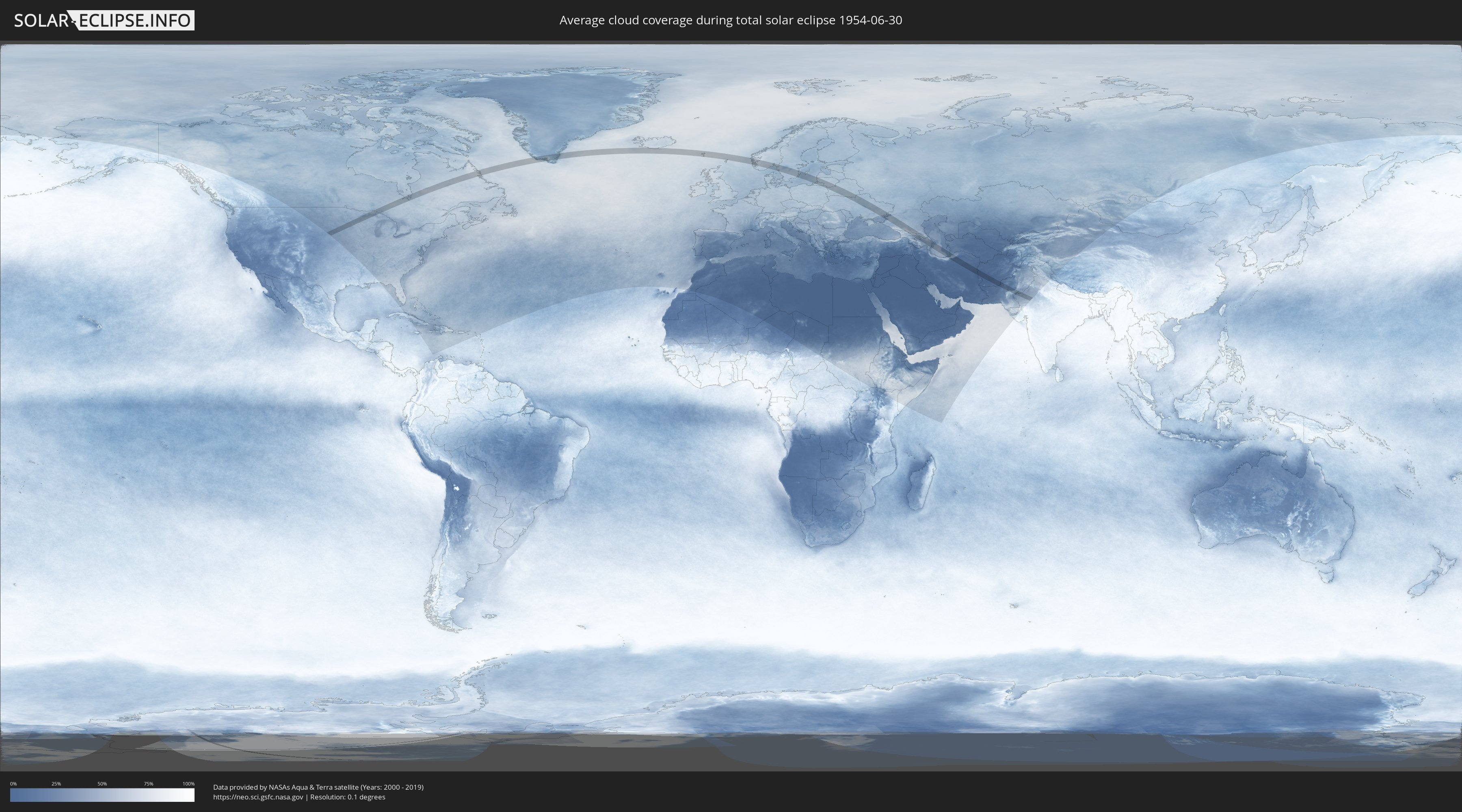
Wie wird das Wetter während der totalen Sonnenfinsternis am 30.06.1954?
Wo ist der beste Ort, um die totale Sonnenfinsternis vom 30.06.1954 zu beobachten?
Die folgenden Karten zeigen die durchschnittliche Bewölkung für den Tag, an dem die totale Sonnenfinsternis
stattfindet. Mit Hilfe der Karten lässt sich der Ort entlang des Finsternispfades eingrenzen,
der die besten Aussichen auf einen klaren wolkenfreien Himmel bietet.
Trotzdem muss man immer lokale Gegenenheiten beachten und sollte sich genau über das Wetter an seinem
gewählten Beobachtungsort informieren.
Die Daten stammen von den beiden NASA-Satelliten
AQUA und TERRA
und wurden über einen Zeitraum von 19 Jahren (2000 - 2019) gemittelt.

Detaillierte Länderkarten
 Russland
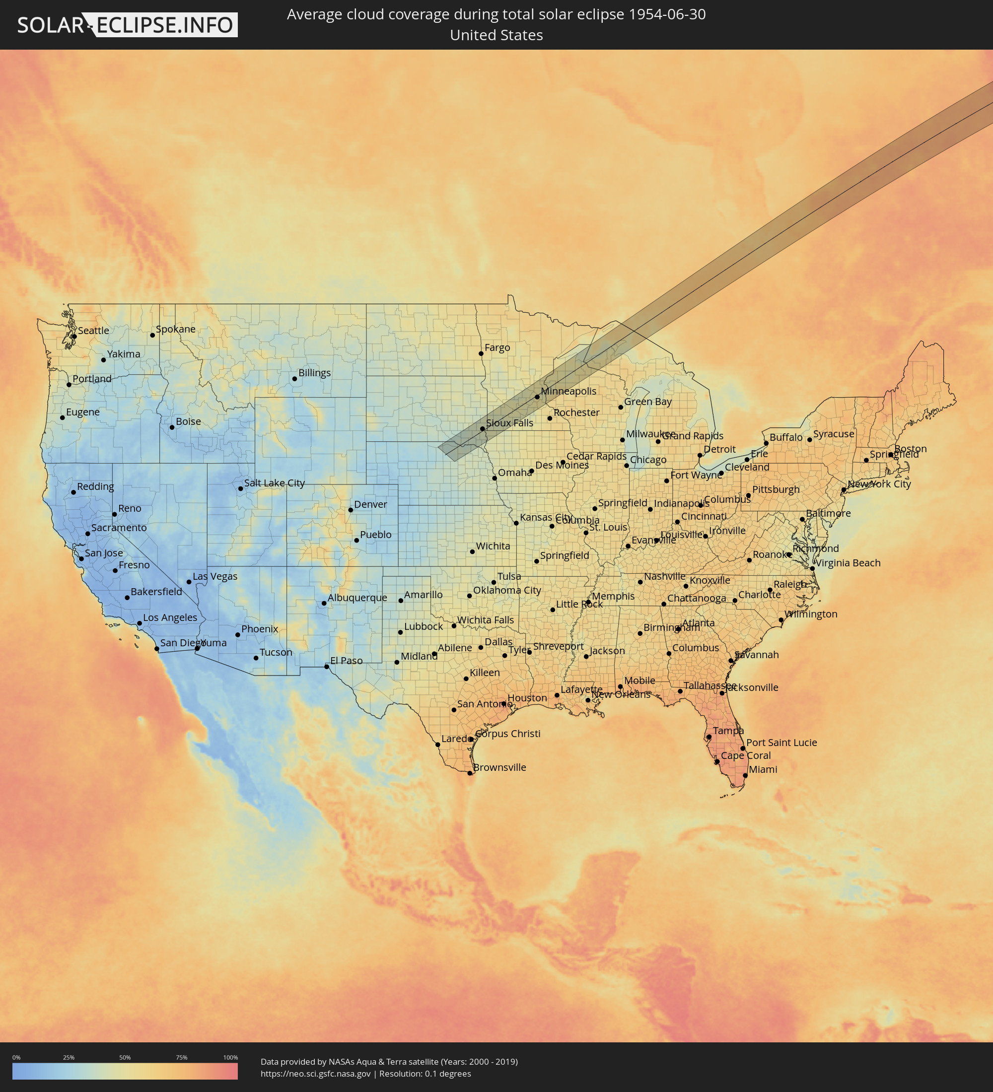 Vereinigte Staaten
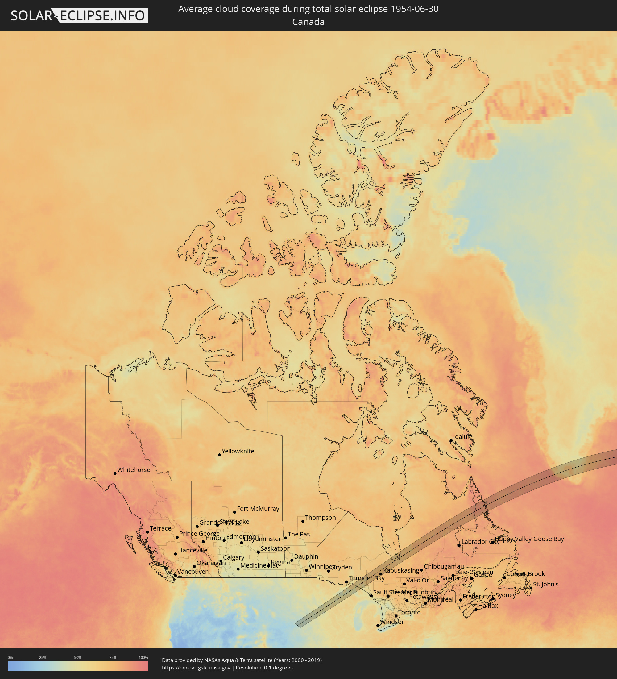 Kanada
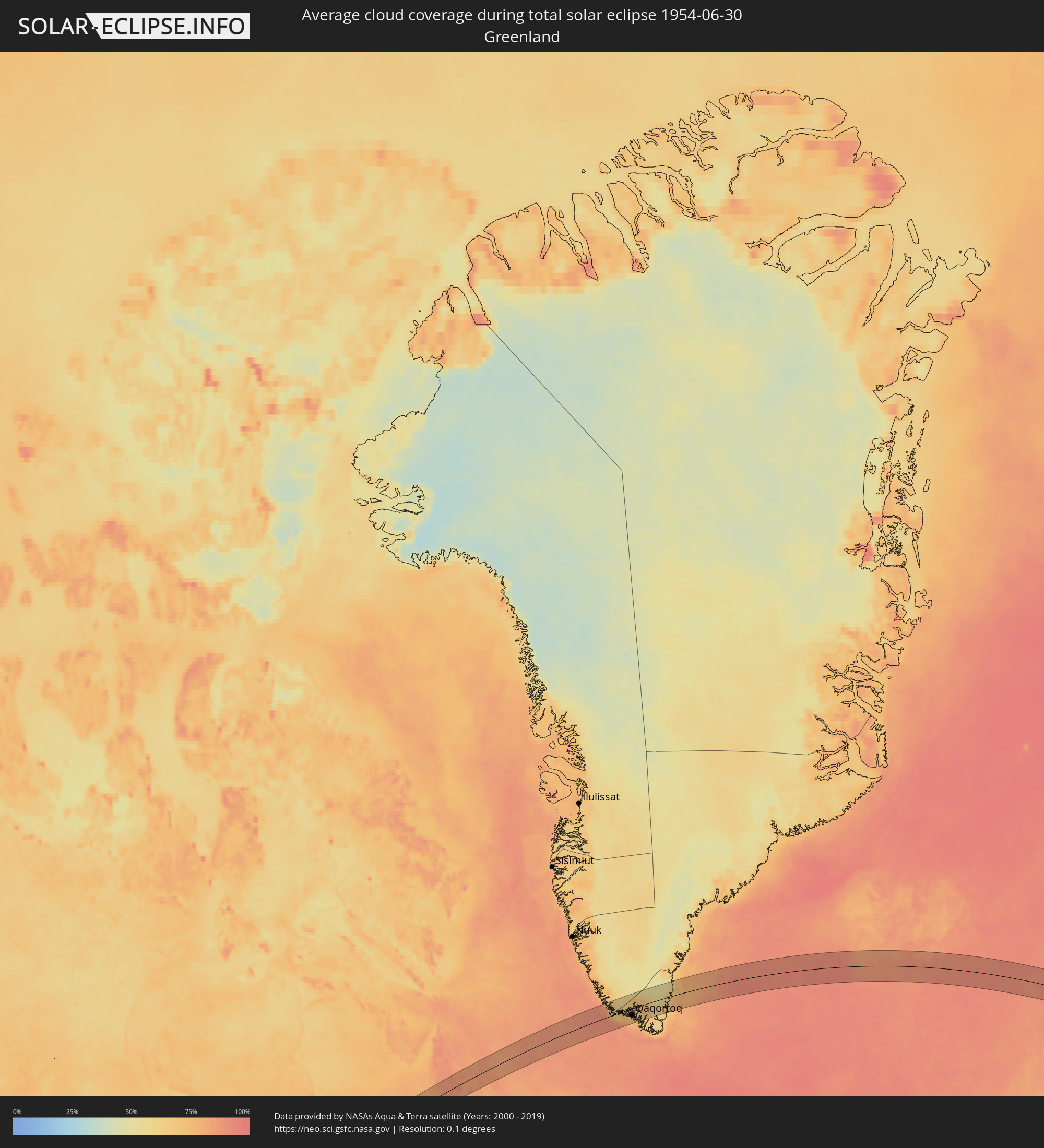 Grönland
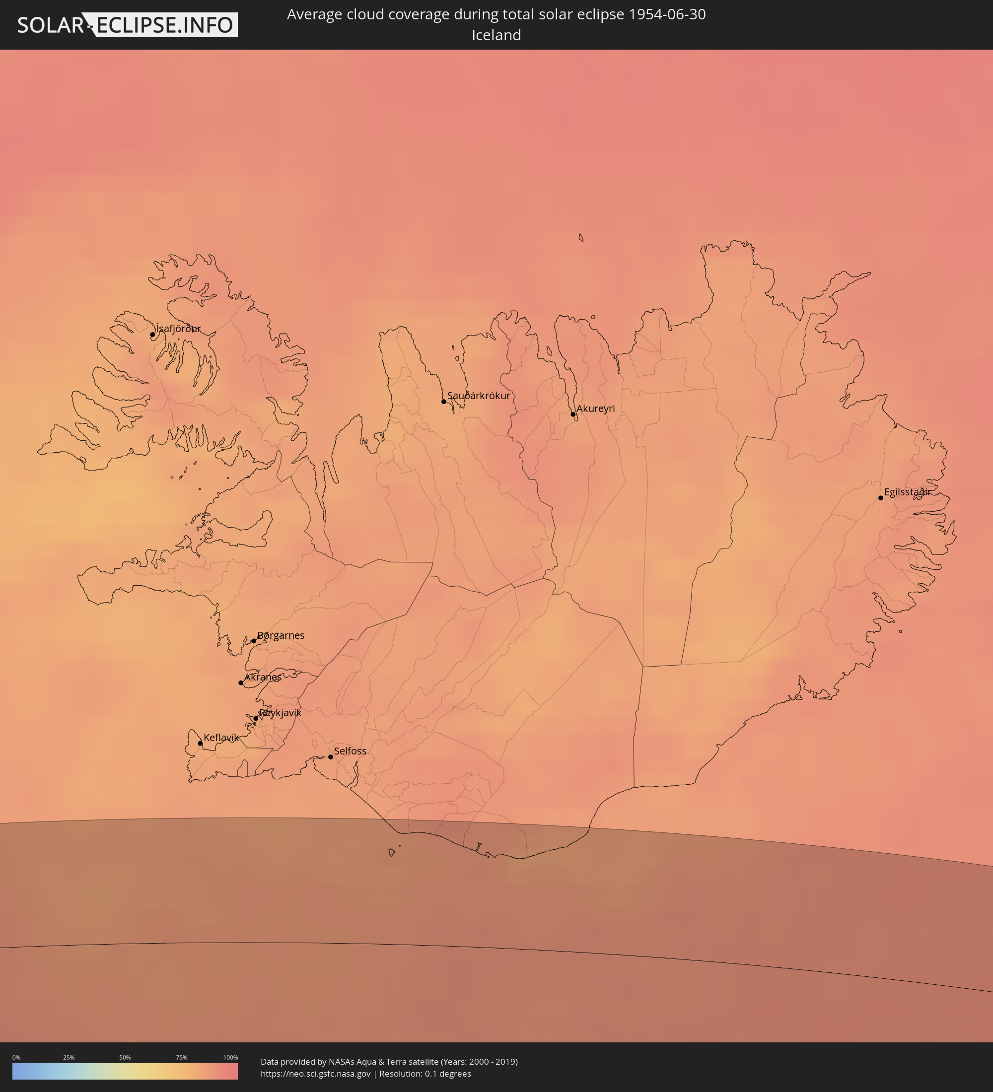 Island
 Vereinigtes Königreich
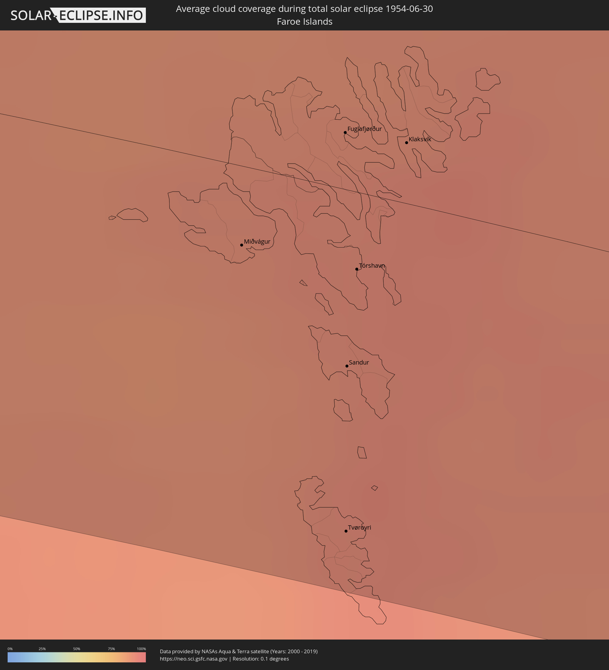 Färöer
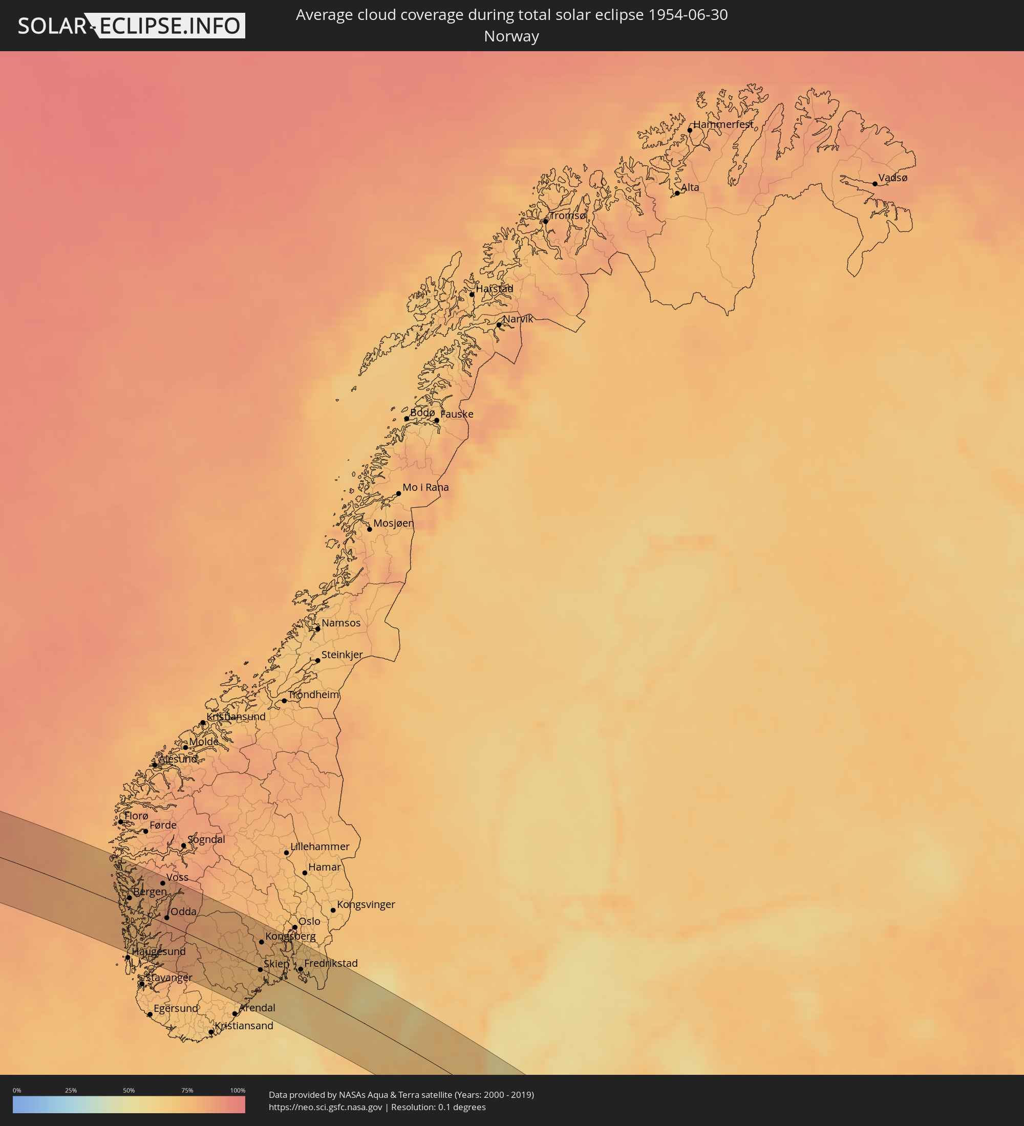 Norwegen
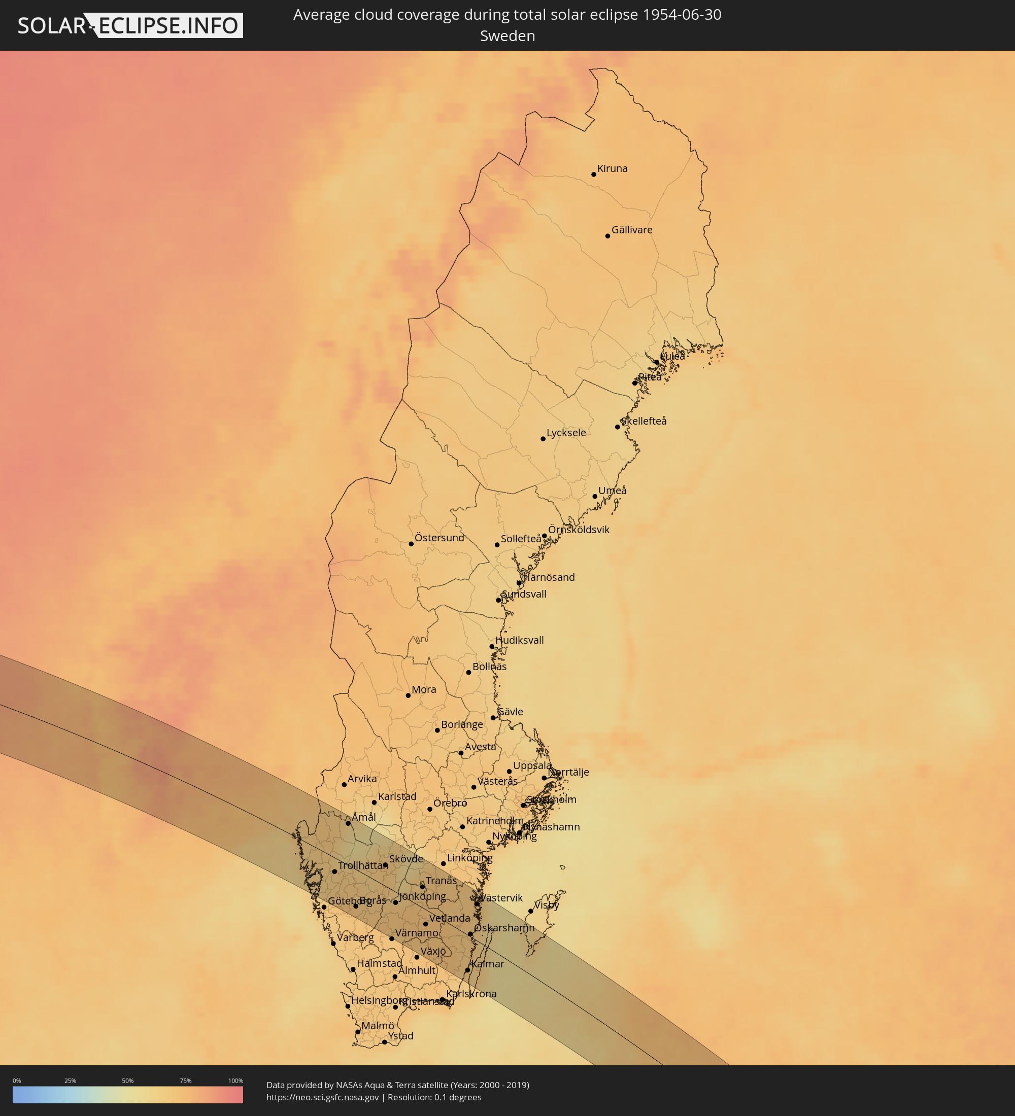 Schweden
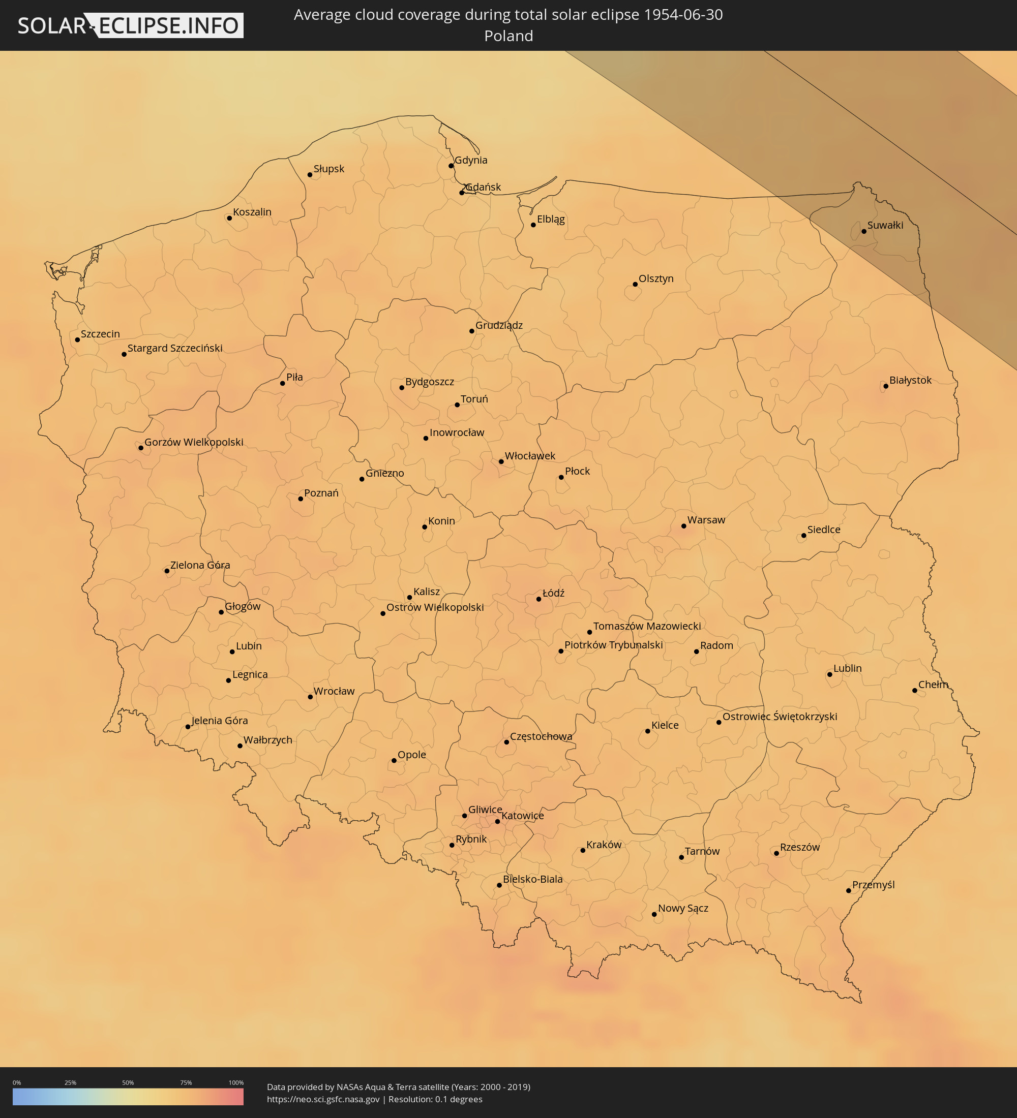 Polen
Polen
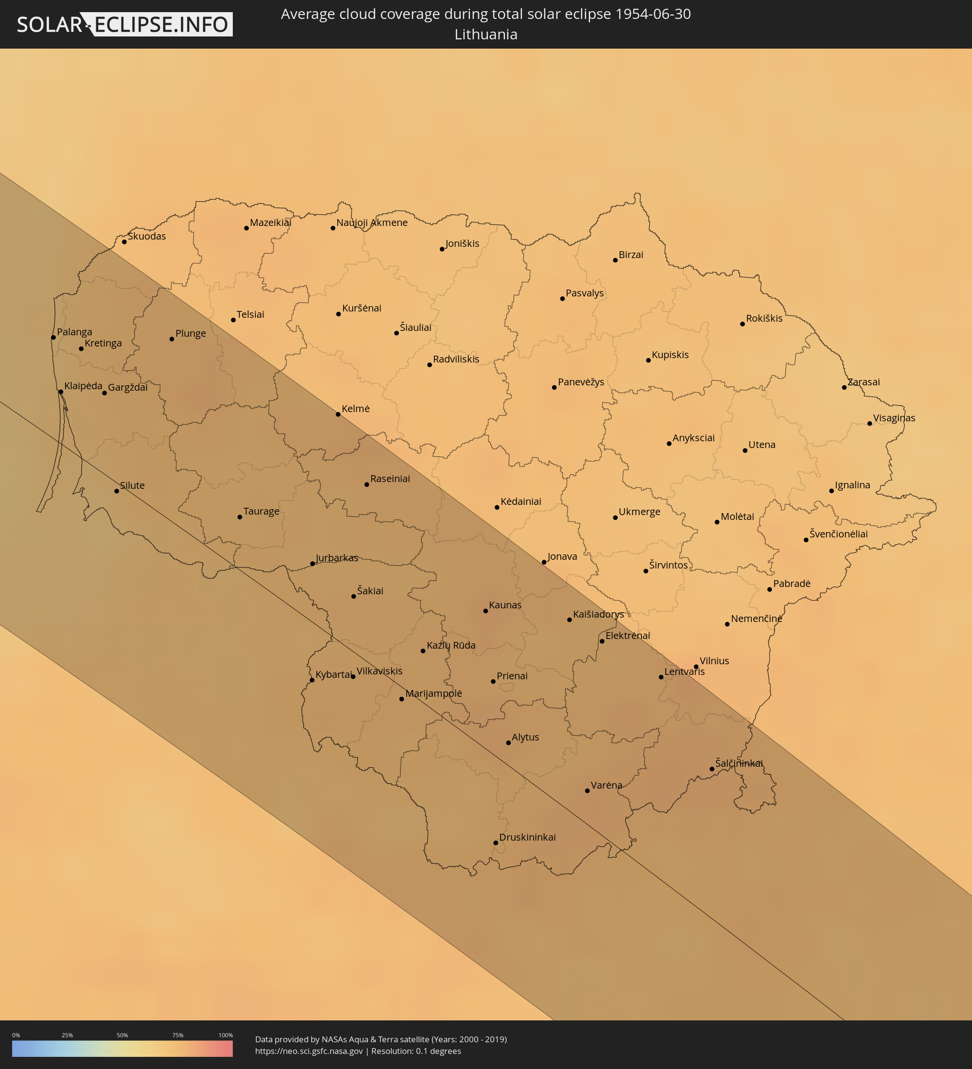 Litauen
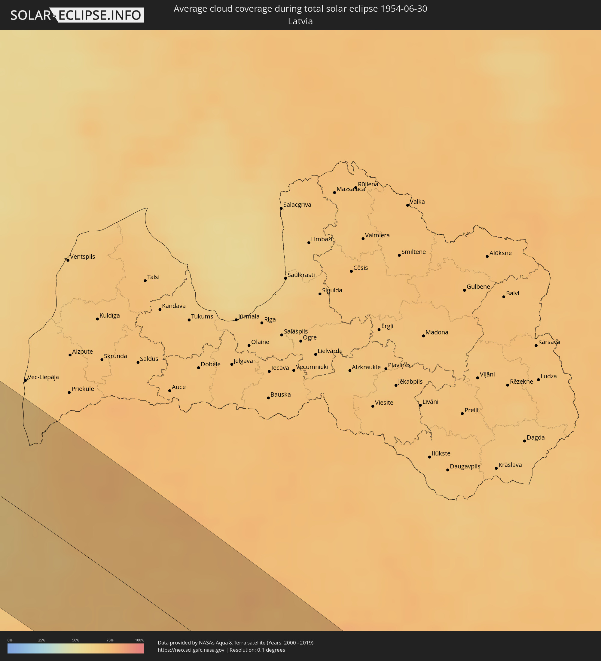 Lettland
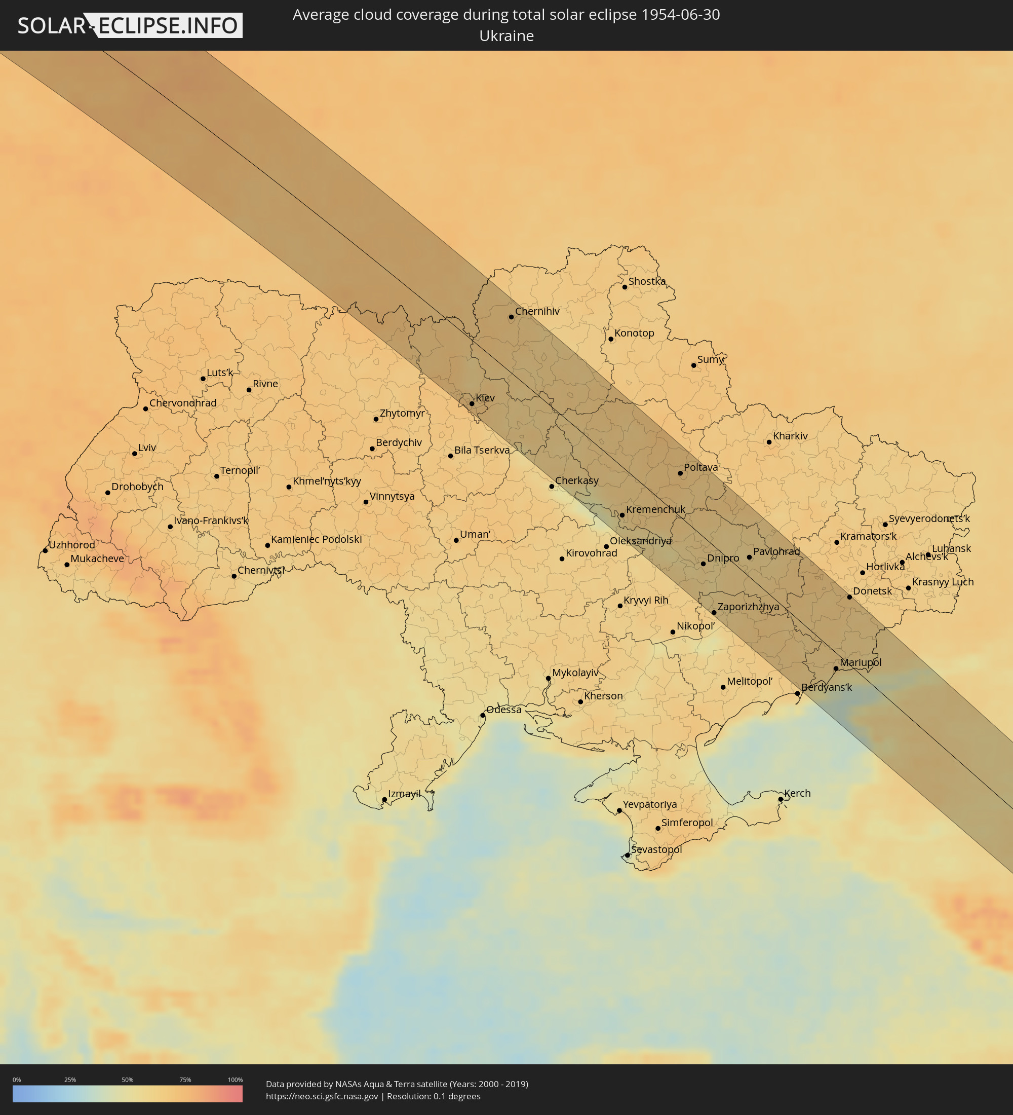 Ukraine
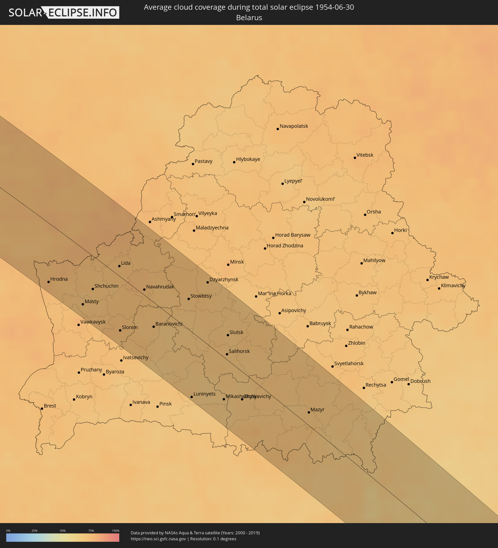 Weißrussland
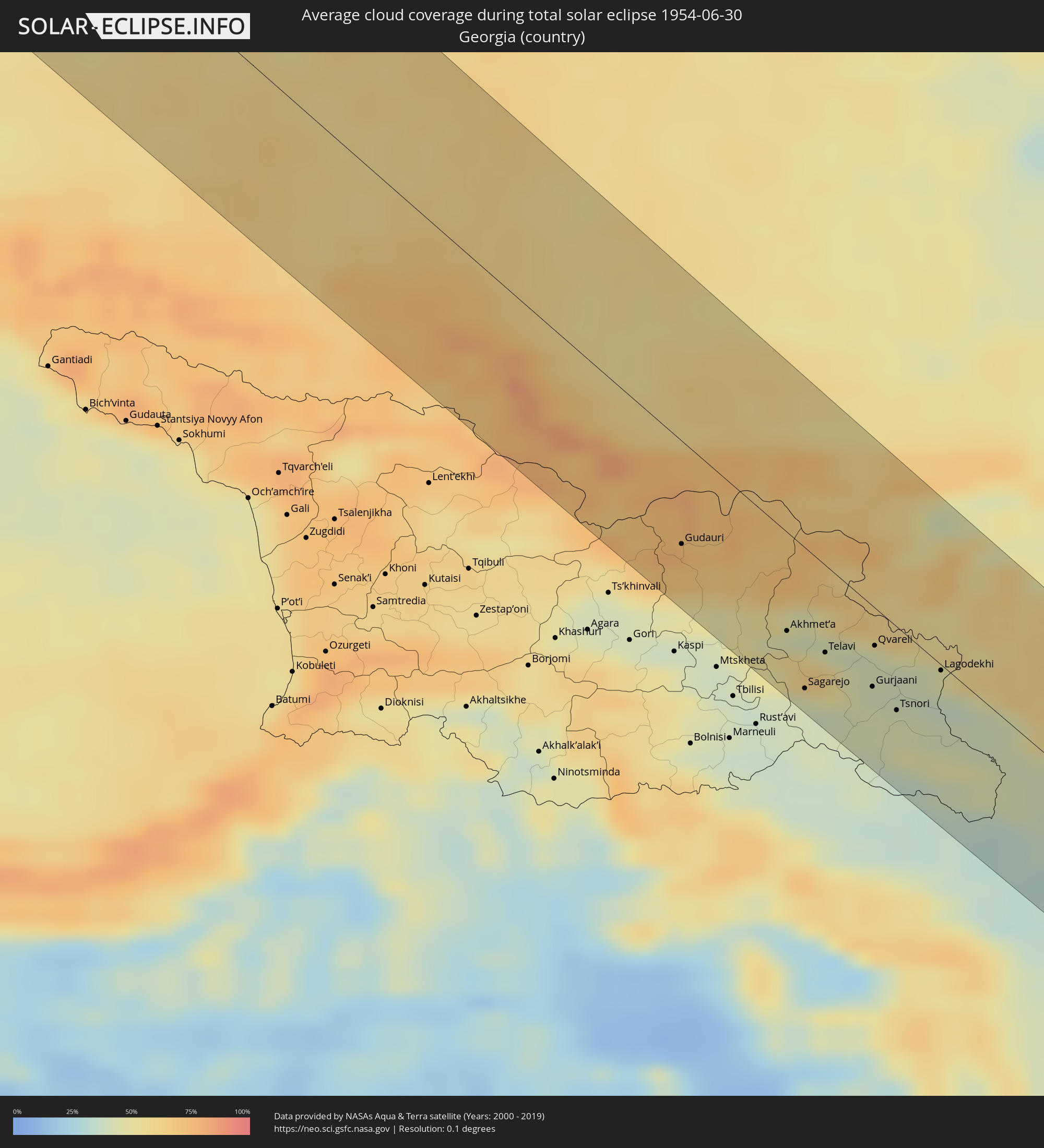 Georgien
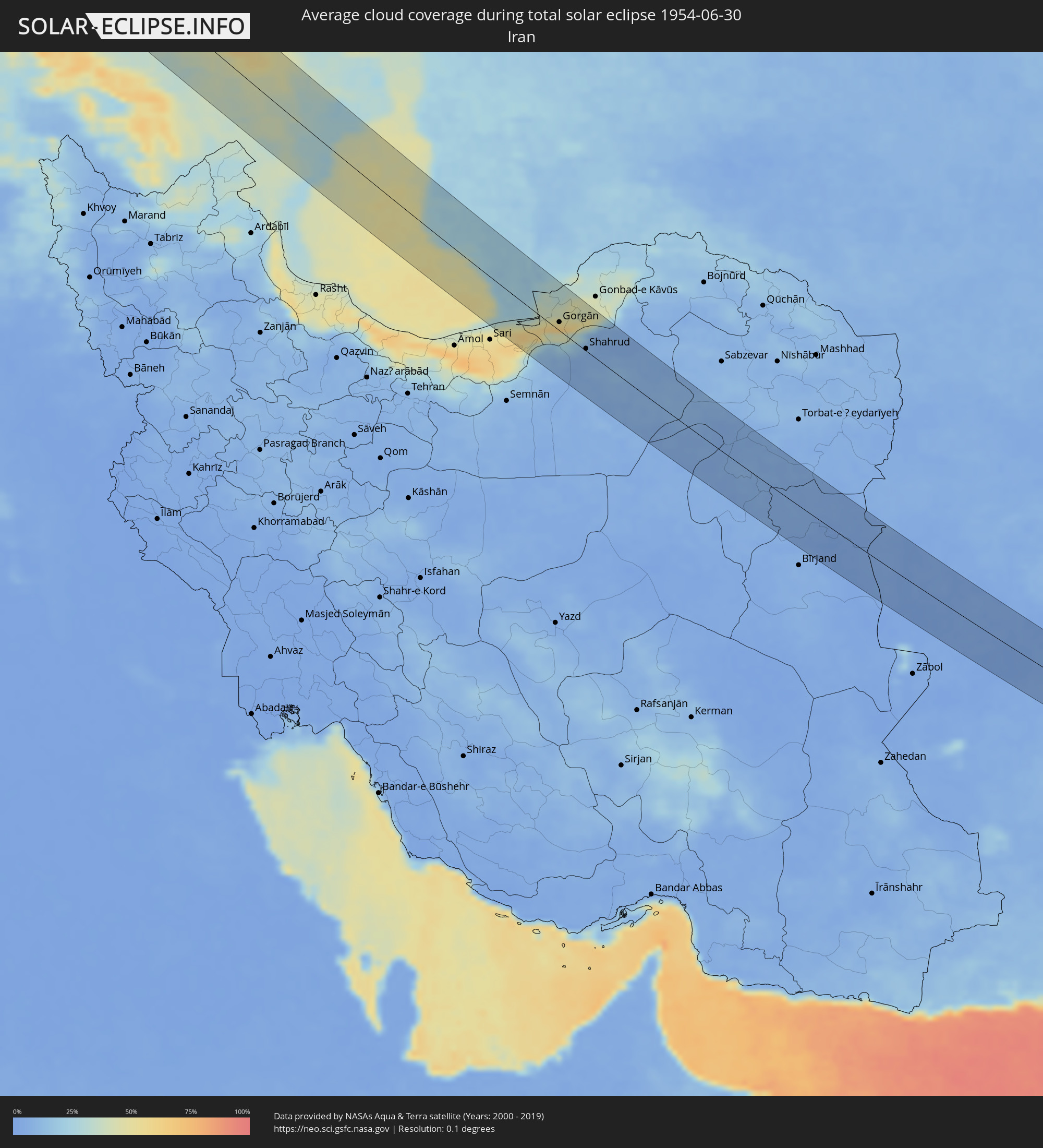 Iran
Iran
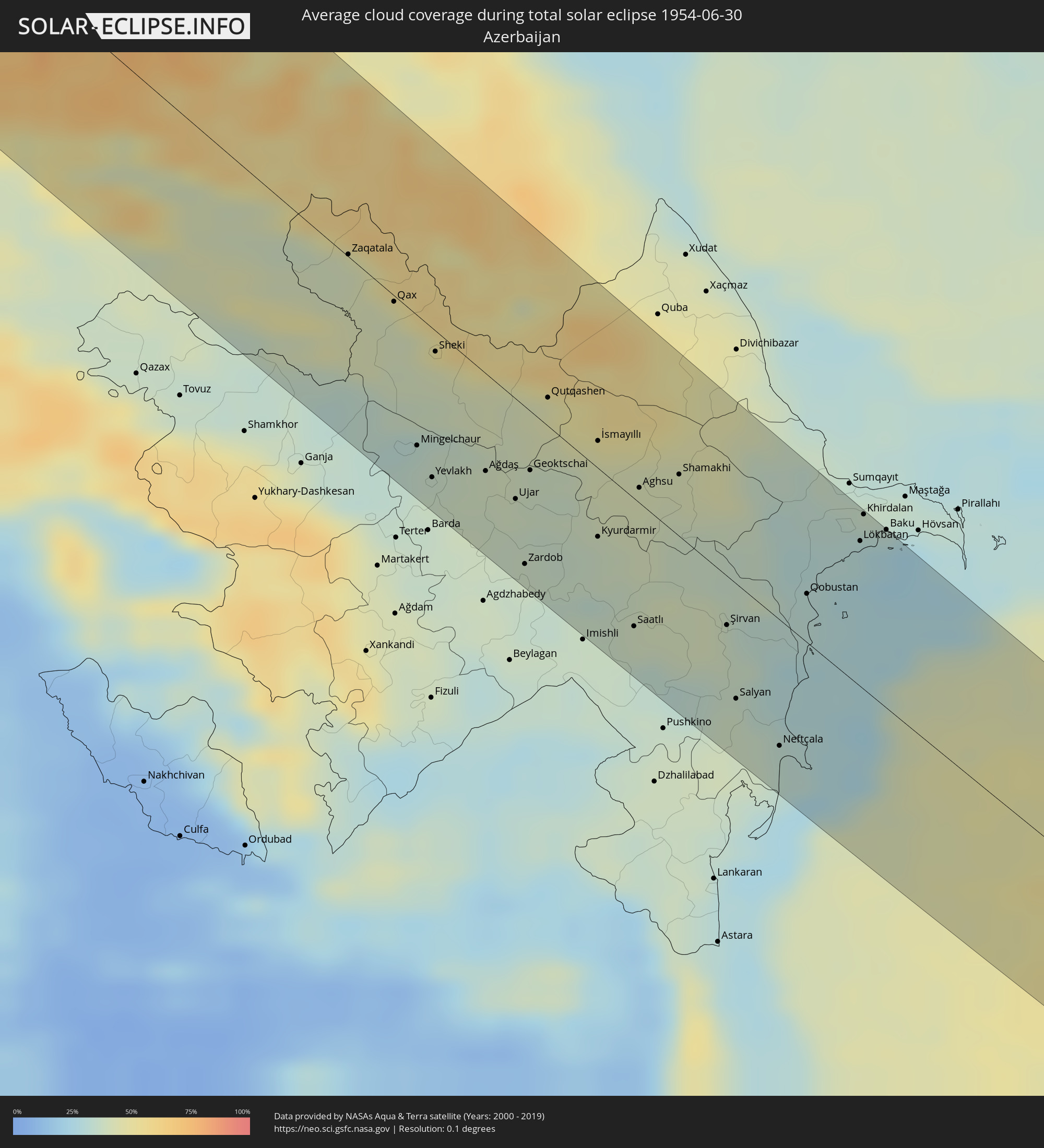 Aserbaidschan
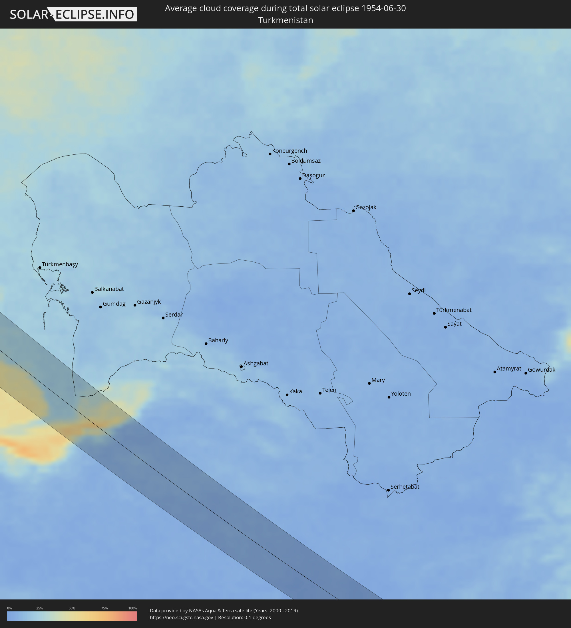 Turkmenistan
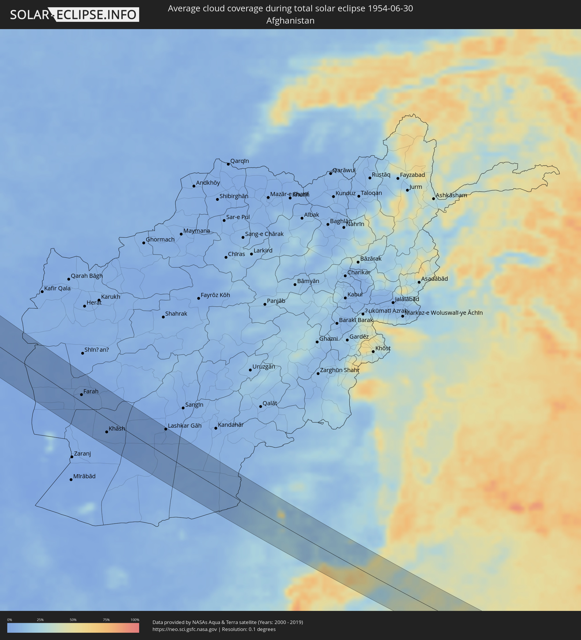 Afghanistan
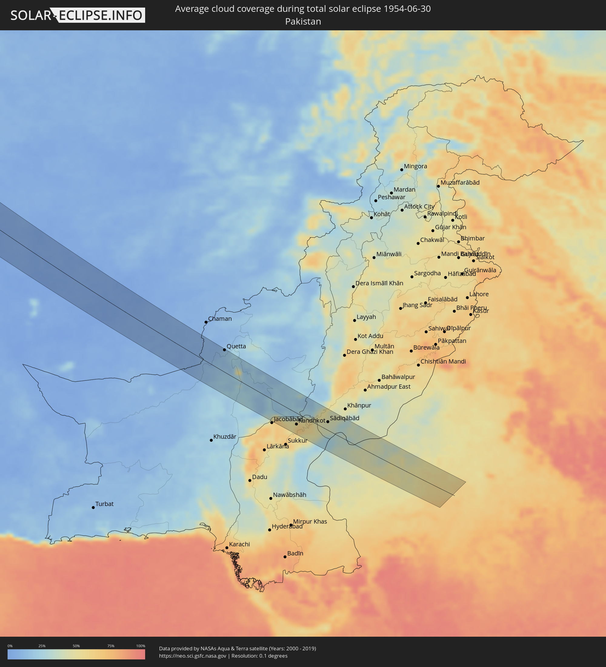 Pakistan
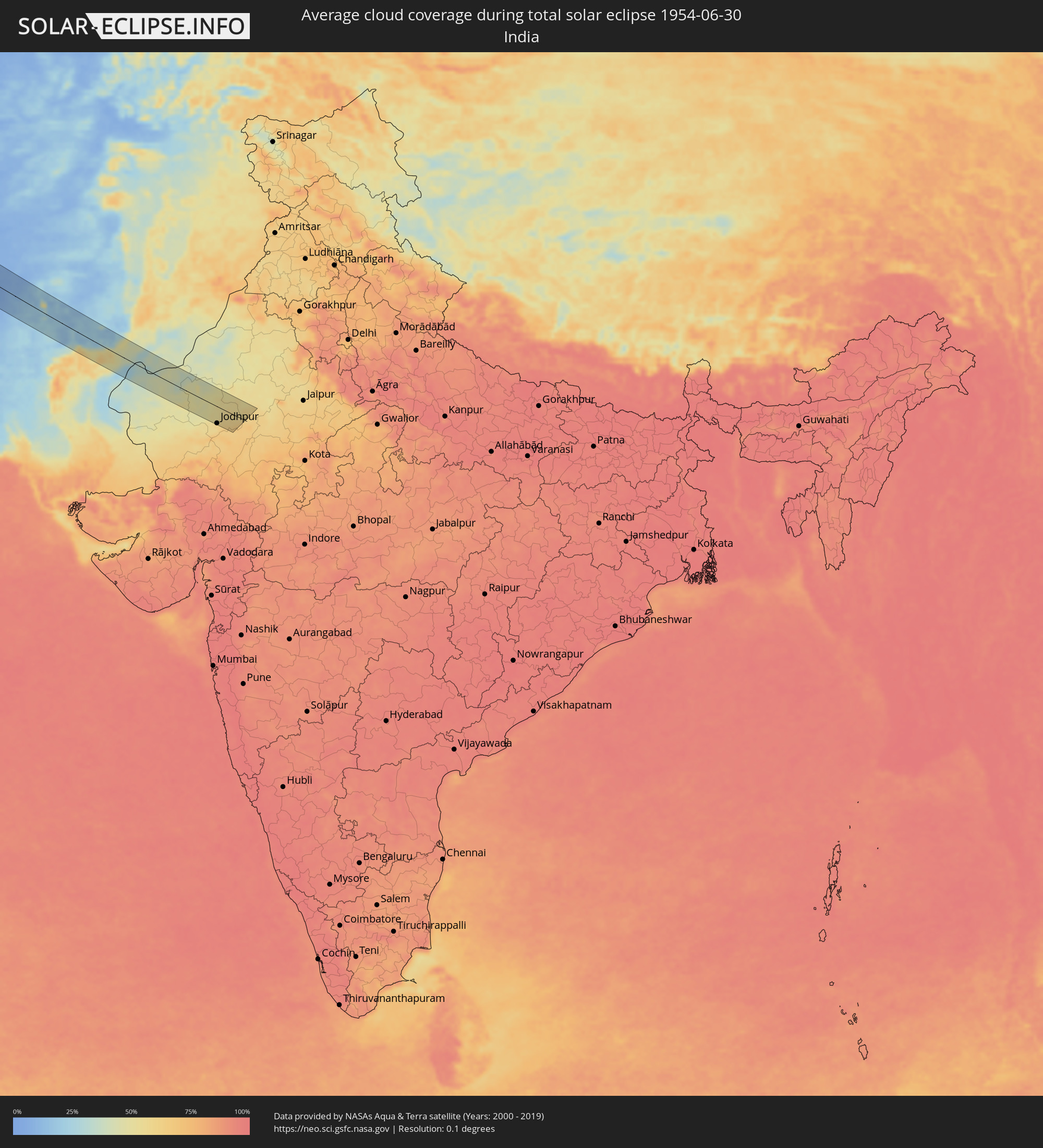 Indien
Orte im Finsternispfad
Die nachfolgene Tabelle zeigt Städte und Orte mit mehr als 5.000 Einwohnern, die sich im Finsternispfad befinden. Städte mit mehr als 100.000 Einwohnern sind dick gekennzeichnet. Mit einem Klick auf den Ort öffnet sich eine Detailkarte die die Lage des jeweiligen Ortes zusammen mit dem Verlauf der zentralen Finsternis präsentiert.
| Ort | Typ | Dauer der Verfinsterung | Ortszeit bei maximaler Verfinsterung | Entfernung zur Zentrallinie | Ø Bewölkung |
|
Sioux Falls, South Dakota
|
total | - | 06:07:53 UTC-05:00 | 17 km | 41% |
|
Mankato, Minnesota
|
total | - | 06:07:29 UTC-05:00 | 57 km | 46% |
|
Elk River, Minnesota
|
total | - | 06:08:37 UTC-05:00 | 35 km | 49% |
|
Shakopee, Minnesota
|
total | - | 06:08:01 UTC-05:00 | 22 km | 49% |
|
Plymouth, Minnesota
|
total | - | 06:08:14 UTC-05:00 | 4 km | 48% |
|
West Coon Rapids, Minnesota
|
total | - | 06:08:22 UTC-05:00 | 22 km | 52% |
|
Bloomington, Minnesota
|
total | - | 06:08:00 UTC-05:00 | 23 km | 52% |
|
Minneapolis, Minnesota
|
total | - | 06:08:08 UTC-05:00 | 19 km | 54% |
|
Lakeville, Minnesota
|
total | - | 06:07:45 UTC-05:00 | 43 km | 50% |
|
White Bear Lake, Minnesota
|
total | - | 06:08:10 UTC-05:00 | 16 km | 46% |
|
Woodbury, Minnesota
|
total | - | 06:07:58 UTC-05:00 | 34 km | 50% |
|
Hastings, Minnesota
|
total | - | 06:07:44 UTC-05:00 | 55 km | 52% |
|
Kapuskasing, Ontario
|
total | - | 07:11:14 UTC-04:00 | 54 km | 72% |
|
Qaqortoq, Kujalleq
|
total | - | 08:39:44 UTC-03:00 | 34 km | 61% |
|
Miðvágur, Vágar
|
total | - | 12:18:34 UTC+00:00 | 15 km | 90% |
|
Fuglafjørður, Eysturoy
|
total | - | 12:18:57 UTC+00:00 | 10 km | 91% |
|
Tvøroyri, Suðuroy
|
total | - | 12:19:08 UTC+00:00 | 64 km | 91% |
|
Sandur, Sandoy
|
total | - | 12:19:03 UTC+00:00 | 33 km | 91% |
|
Tórshavn, Streymoy
|
total | - | 12:19:03 UTC+00:00 | 14 km | 91% |
|
Klaksvík, Norðoyar
|
total | - | 12:19:12 UTC+00:00 | 11 km | 92% |
|
Bergen, Hordaland
|
total | - | 13:33:26 UTC+01:00 | 20 km | 75% |
|
Leirvik, Hordaland
|
total | - | 13:34:11 UTC+01:00 | 44 km | 74% |
|
Skien, Telemark
|
total | - | 13:39:18 UTC+01:00 | 9 km | 73% |
|
Kongsberg, Buskerud
|
total | - | 13:38:51 UTC+01:00 | 46 km | 76% |
|
Drammen, Buskerud
|
total | - | 13:39:21 UTC+01:00 | 67 km | 74% |
|
Sandefjord, Vestfold
|
total | - | 13:40:03 UTC+01:00 | 12 km | 70% |
|
Tønsberg, Vestfold
|
total | - | 13:40:06 UTC+01:00 | 27 km | 71% |
|
Drøbak, Akershus
|
total | - | 13:39:53 UTC+01:00 | 69 km | 71% |
|
Moss, Østfold
|
total | - | 13:40:11 UTC+01:00 | 49 km | 70% |
|
Fredrikstad, Østfold
|
total | - | 13:40:43 UTC+01:00 | 34 km | 71% |
|
Askim, Østfold
|
total | - | 13:40:32 UTC+01:00 | 75 km | 70% |
|
Halden, Østfold
|
total | - | 13:41:18 UTC+01:00 | 36 km | 67% |
|
Uddevalla, Västra Götaland
|
total | - | 13:42:49 UTC+01:00 | 28 km | 67% |
|
Kungälv, Västra Götaland
|
total | - | 13:43:26 UTC+01:00 | 71 km | 67% |
|
Trollhättan, Västra Götaland
|
total | - | 13:43:16 UTC+01:00 | 22 km | 67% |
|
Alingsås, Västra Götaland
|
total | - | 13:43:58 UTC+01:00 | 50 km | 69% |
|
Borås, Västra Götaland
|
total | - | 13:44:40 UTC+01:00 | 59 km | 71% |
|
Lidköping, Västra Götaland
|
total | - | 13:43:56 UTC+01:00 | 24 km | 63% |
|
Skara, Västra Götaland
|
total | - | 13:44:22 UTC+01:00 | 26 km | 67% |
|
Skövde, Västra Götaland
|
total | - | 13:44:48 UTC+01:00 | 33 km | 70% |
|
Jönköping, Jönköping
|
total | - | 13:45:54 UTC+01:00 | 22 km | 68% |
|
Kalmar, Kalmar
|
total | - | 13:49:45 UTC+01:00 | 57 km | 68% |
|
Oskarshamn, Kalmar
|
total | - | 13:49:00 UTC+01:00 | 7 km | 68% |
|
Västervik, Kalmar
|
total | - | 13:48:31 UTC+01:00 | 57 km | 68% |
|
Nīca, Nīca
|
total | - | 15:54:56 UTC+03:00 | 73 km | 68% |
|
Klaipėda, Klaipėda County
|
total | - | 15:55:57 UTC+03:00 | 18 km | 70% |
|
Rucava, Rucavas
|
total | - | 15:55:18 UTC+03:00 | 60 km | 70% |
|
Kretinga, Klaipėda County
|
total | - | 15:55:50 UTC+03:00 | 37 km | 72% |
|
Gargždai, Klaipėda County
|
total | - | 15:56:14 UTC+03:00 | 30 km | 72% |
|
Silute, Klaipėda County
|
total | - | 15:56:53 UTC+03:00 | 3 km | 66% |
|
Plunge, Telšiai County
|
total | - | 15:56:21 UTC+03:00 | 64 km | 75% |
|
Taurage, Tauragė County
|
total | - | 15:57:48 UTC+03:00 | 20 km | 73% |
|
Gołdap, Warmian-Masurian Voivodeship
|
total | - | 13:59:19 UTC+01:00 | 68 km | 74% |
|
Jurbarkas, Tauragė County
|
total | - | 15:58:32 UTC+03:00 | 21 km | 73% |
|
Suwałki, Podlasie
|
total | - | 14:00:14 UTC+01:00 | 61 km | 76% |
|
Sejny, Podlasie
|
total | - | 14:00:39 UTC+01:00 | 49 km | 73% |
|
Marijampolė, Marijampolė County
|
total | - | 15:59:54 UTC+03:00 | 10 km | 75% |
|
Hrodna, Grodnenskaya
|
total | - | 16:01:47 UTC+03:00 | 65 km | 76% |
|
Kaunas, Kaunas County
|
total | - | 15:59:52 UTC+03:00 | 47 km | 76% |
|
Druskininkai, Alytus County
|
total | - | 16:01:23 UTC+03:00 | 36 km | 75% |
|
Alytus, Alytus County
|
total | - | 16:00:50 UTC+03:00 | 8 km | 74% |
|
Masty, Grodnenskaya
|
total | - | 16:02:54 UTC+03:00 | 62 km | 73% |
|
Elektrėnai, Vilnius County
|
total | - | 16:00:45 UTC+03:00 | 66 km | 73% |
|
Shchuchin, Grodnenskaya
|
total | - | 16:02:47 UTC+03:00 | 37 km | 71% |
|
Lida, Grodnenskaya
|
total | - | 16:02:49 UTC+03:00 | 20 km | 74% |
|
Slonim, Grodnenskaya
|
total | - | 16:04:10 UTC+03:00 | 60 km | 73% |
|
Navahrudak, Grodnenskaya
|
total | - | 16:03:46 UTC+03:00 | 21 km | 74% |
|
Baranovichi, Brest
|
total | - | 16:04:43 UTC+03:00 | 34 km | 70% |
|
Luninyets, Brest
|
total | - | 16:06:56 UTC+03:00 | 72 km | 67% |
|
Dzyarzhynsk, Minsk
|
total | - | 16:04:46 UTC+03:00 | 67 km | 71% |
|
Salihorsk, Minsk
|
total | - | 16:06:39 UTC+03:00 | 6 km | 68% |
|
Slutsk, Minsk
|
total | - | 16:06:15 UTC+03:00 | 32 km | 70% |
|
Mazyr, Gomel
|
total | - | 16:09:21 UTC+03:00 | 14 km | 71% |
|
Kiev, Kyiv City
|
total | - | 16:13:12 UTC+03:00 | 68 km | 71% |
|
Brovary, Kiev
|
total | - | 16:13:18 UTC+03:00 | 53 km | 69% |
|
Chernihiv, Chernihiv
|
total | - | 16:11:56 UTC+03:00 | 62 km | 65% |
|
Nizhyn, Chernihiv
|
total | - | 16:13:12 UTC+03:00 | 46 km | 63% |
|
Kremenchuk, Poltava
|
total | - | 16:17:52 UTC+03:00 | 53 km | 57% |
|
Poltava, Poltava
|
total | - | 16:17:43 UTC+03:00 | 47 km | 69% |
|
Dniprodzerzhyns’k, Dnipropetrovsk
|
total | - | 16:19:42 UTC+03:00 | 42 km | 59% |
|
Dnipro, Dnipropetrovsk
|
total | - | 16:20:04 UTC+03:00 | 37 km | 62% |
|
Zaporizhzhya, Zaporizhia
|
total | - | 16:21:21 UTC+03:00 | 74 km | 59% |
|
Pavlohrad, Dnipropetrovsk
|
total | - | 16:20:31 UTC+03:00 | 28 km | 61% |
|
Mariupol, Donetsk
|
total | - | 16:24:09 UTC+03:00 | 26 km | 56% |
|
Donetsk, Donetsk
|
total | - | 16:22:38 UTC+03:00 | 75 km | 65% |
|
Yeysk, Krasnodarskiy
|
total | - | 16:25:17 UTC+03:00 | 17 km | 54% |
|
Taganrog, Rostov Oblast
|
total | - | 16:24:41 UTC+03:00 | 64 km | 51% |
|
Armavir, Krasnodarskiy
|
total | - | 16:29:53 UTC+03:00 | 25 km | 59% |
|
Nevinnomyssk, Stavropol'skiy
|
total | - | 16:30:55 UTC+03:00 | 8 km | 62% |
|
Stavropol’, Stavropol'skiy
|
total | - | 16:30:12 UTC+03:00 | 41 km | 59% |
|
Cherkessk, Karachayevo-Cherkesiya
|
total | - | 16:31:41 UTC+03:00 | 35 km | 59% |
|
Kislovodsk, Stavropol'skiy
|
total | - | 16:32:32 UTC+03:00 | 23 km | 70% |
|
Yessentuki, Stavropol'skiy
|
total | - | 16:32:22 UTC+03:00 | 16 km | 68% |
|
Pyatigorsk, Stavropol'skiy
|
total | - | 16:32:26 UTC+03:00 | 13 km | 63% |
|
Nal’chik, Kabardino-Balkariya
|
total | - | 16:33:39 UTC+03:00 | 17 km | 63% |
|
Gudauri
|
total | - | 16:35:46 UTC+03:00 | 48 km | 74% |
|
Vladikavkaz, North Ossetia
|
total | - | 16:34:52 UTC+03:00 | 15 km | 73% |
|
Nazran’, Ingushetiya
|
total | - | 16:34:34 UTC+03:00 | 35 km | 61% |
|
Akhmet’a, Kakheti
|
total | - | 16:36:48 UTC+03:00 | 43 km | 57% |
|
Sagarejo, Kakheti
|
total | - | 16:37:21 UTC+03:00 | 65 km | 41% |
|
Telavi, Kakheti
|
total | - | 16:37:05 UTC+03:00 | 45 km | 54% |
|
Gurjaani, Kakheti
|
total | - | 16:37:30 UTC+03:00 | 36 km | 43% |
|
Qvareli, Kakheti
|
total | - | 16:37:09 UTC+03:00 | 17 km | 43% |
|
Tsnori
|
total | - | 16:37:46 UTC+03:00 | 45 km | 44% |
|
Lagodekhi, Kakheti
|
total | - | 16:37:31 UTC+03:00 | 22 km | 40% |
|
Mingelchaur, Mingǝcevir
|
total | - | 16:39:34 UTC+03:00 | 50 km | 34% |
|
Yevlakh, Yevlax City
|
total | - | 16:39:50 UTC+03:00 | 58 km | 37% |
|
Sheki, Shaki City
|
total | - | 16:38:52 UTC+03:00 | 8 km | 43% |
|
Ağdaş, Ağdaş
|
total | - | 16:39:53 UTC+03:00 | 46 km | 38% |
|
Geoktschai, Göyçay
|
total | - | 16:39:57 UTC+03:00 | 25 km | 38% |
|
Kyurdarmir, Kürdǝmir
|
total | - | 16:40:34 UTC+03:00 | 27 km | 38% |
|
Saatlı, Saatlı
|
total | - | 16:41:18 UTC+03:00 | 50 km | 38% |
|
Shamakhi, Şamaxı
|
total | - | 16:40:13 UTC+03:00 | 24 km | 41% |
|
Şirvan, Shirvan
|
total | - | 16:41:26 UTC+03:00 | 19 km | 39% |
|
Salyan, Salyan
|
total | - | 16:42:01 UTC+03:00 | 46 km | 37% |
|
Neftçala, Neftçala
|
total | - | 16:42:26 UTC+03:00 | 50 km | 34% |
|
Baku, Baki
|
total | - | 16:40:55 UTC+03:00 | 71 km | 32% |
|
Nekā, Māzandarān
|
total | - | 17:17:24 UTC+03:30 | 72 km | 51% |
|
Behshahr, Māzandarān
|
total | - | 17:17:21 UTC+03:30 | 51 km | 60% |
|
Dāmghān, Semnān
|
total | - | 17:18:12 UTC+03:30 | 53 km | 9% |
|
Gorgān, Golestān
|
total | - | 17:17:11 UTC+03:30 | 12 km | 64% |
|
Shahrud, Semnān
|
total | - | 17:17:51 UTC+03:30 | 6 km | 6% |
|
Gonābād, Razavi Khorasan
|
total | - | 17:20:51 UTC+03:30 | 19 km | 7% |
|
Qā’en, Khorāsān-e Jonūbī
|
total | - | 17:21:42 UTC+03:30 | 29 km | 5% |
|
Anār Darah, Farah
|
total | - | 18:22:44 UTC+04:30 | 26 km | 4% |
|
Farah, Farah
|
total | - | 18:23:10 UTC+04:30 | 15 km | 2% |
|
Khāsh, Nimroz
|
total | - | 18:24:11 UTC+04:30 | 30 km | 3% |
|
Markaz-e Ḩukūmat-e Darwēshān, Helmand
|
total | - | 18:24:24 UTC+04:30 | 20 km | 4% |
|
Lashkar Gāh, Helmand
|
total | - | 18:23:45 UTC+04:30 | 57 km | 2% |
|
Nushki, Balochistān
|
total | - | 18:55:55 UTC+05:00 | 59 km | 8% |
|
Mastung, Balochistān
|
total | - | 18:55:22 UTC+05:00 | 24 km | 17% |
|
Quetta, Balochistān
|
total | - | 18:54:50 UTC+05:00 | 60 km | 15% |
|
Sibi, Balochistān
|
total | - | 18:55:22 UTC+05:00 | 41 km | 17% |
|
Thul, Sindh
|
total | - | 18:56:36 UTC+05:00 | 49 km | 62% |
|
Ghauspur, Sindh
|
total | - | 18:56:37 UTC+05:00 | 49 km | 62% |
|
Kandhkot, Sindh
|
total | - | 18:56:27 UTC+05:00 | 35 km | 60% |
|
Ghotki, Sindh
|
total | - | 18:56:41 UTC+05:00 | 46 km | 49% |
|
Mīrpur Mathelo, Sindh
|
total | - | 18:56:35 UTC+05:00 | 41 km | 49% |
|
Kashmor, Sindh
|
total | - | 18:56:05 UTC+05:00 | 10 km | 54% |
|
Khairpur, Sindh
|
total | - | 18:56:28 UTC+05:00 | 31 km | 48% |
|
Sādiqābād, Punjab
|
total | - | 18:56:02 UTC+05:00 | 22 km | 42% |
|
Pokaran, Rajasthan
|
total | - | 19:26:52 UTC+05:30 | 33 km | 52% |
|
Phalodi, Rajasthan
|
total | - | 19:26:27 UTC+05:30 | 21 km | 46% |
|
Jodhpur, Rajasthan
|
total | - | 19:27:06 UTC+05:30 | 54 km | 59% |
|
Pīpār, Rajasthan
|
total | - | 19:26:44 UTC+05:30 | 17 km | 59% |
|
Merta, Rajasthan
|
total | - | 19:26:13 UTC+05:30 | 35 km | 59% |