Totale Sonnenfinsternis vom 15.02.1961
11 Personen haben diese Sonnenfinsternis beobachtet.
| Wochentag: | Mittwoch |
| Maximale Dauer der Verfinsterung: | 02m45s |
| Maximale Breite des Finsternispfades: | 258 km |
| Saroszyklus: | 120 |
| Bedeckungsgrad: | 100% |
| Magnitude: | 1.036 |
| Gamma: | 0.883 |
Wo kann man die Sonnenfinsternis vom 15.02.1961 sehen?
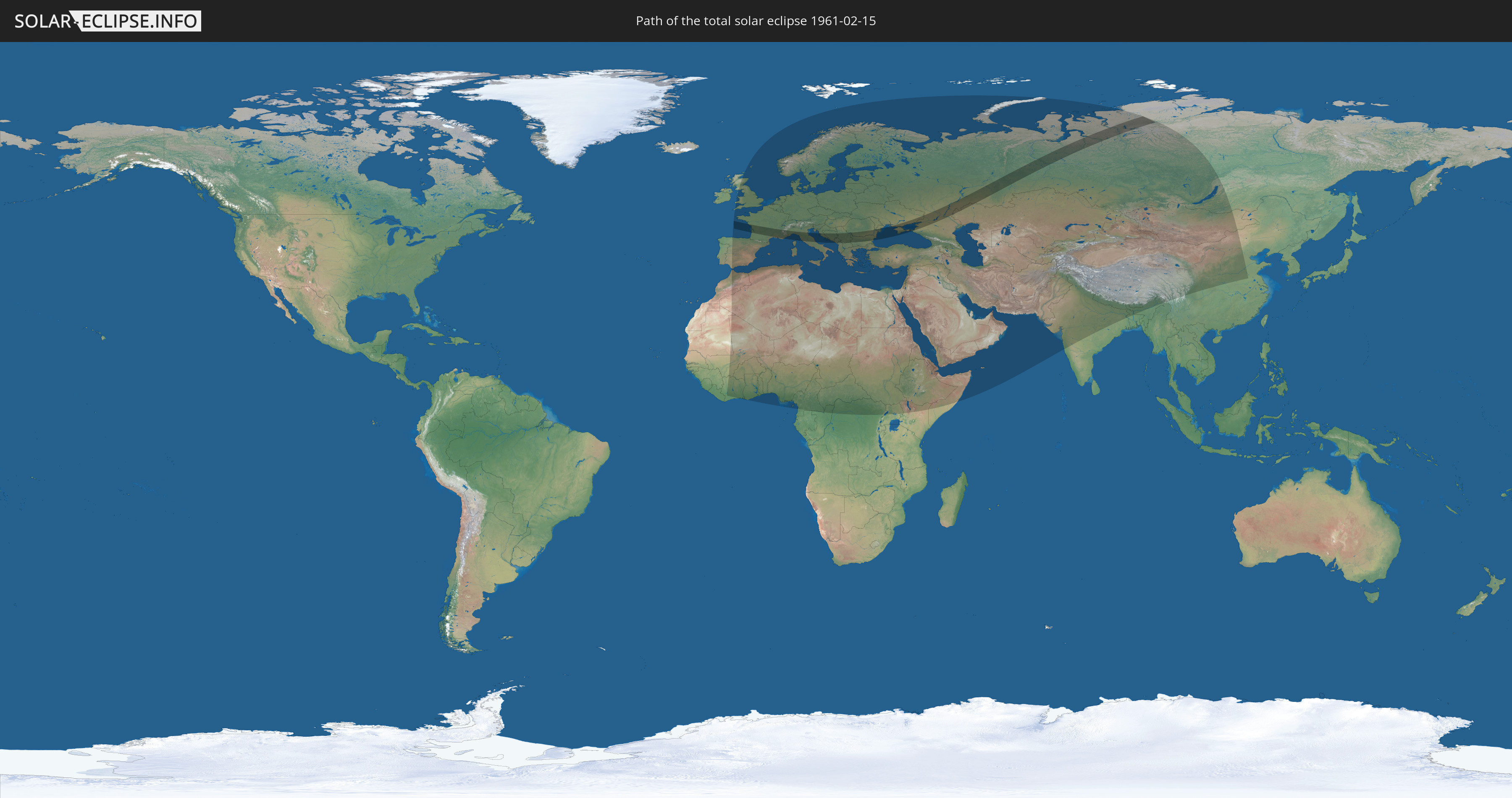
Die Sonnenfinsternis am 15.02.1961 kann man in 106 Ländern als partielle Sonnenfinsternis beobachten.
Der Finsternispfad verläuft durch 15 Länder. Nur in diesen Ländern ist sie als totale Sonnenfinsternis zu sehen.
In den folgenden Ländern ist die Sonnenfinsternis total zu sehen
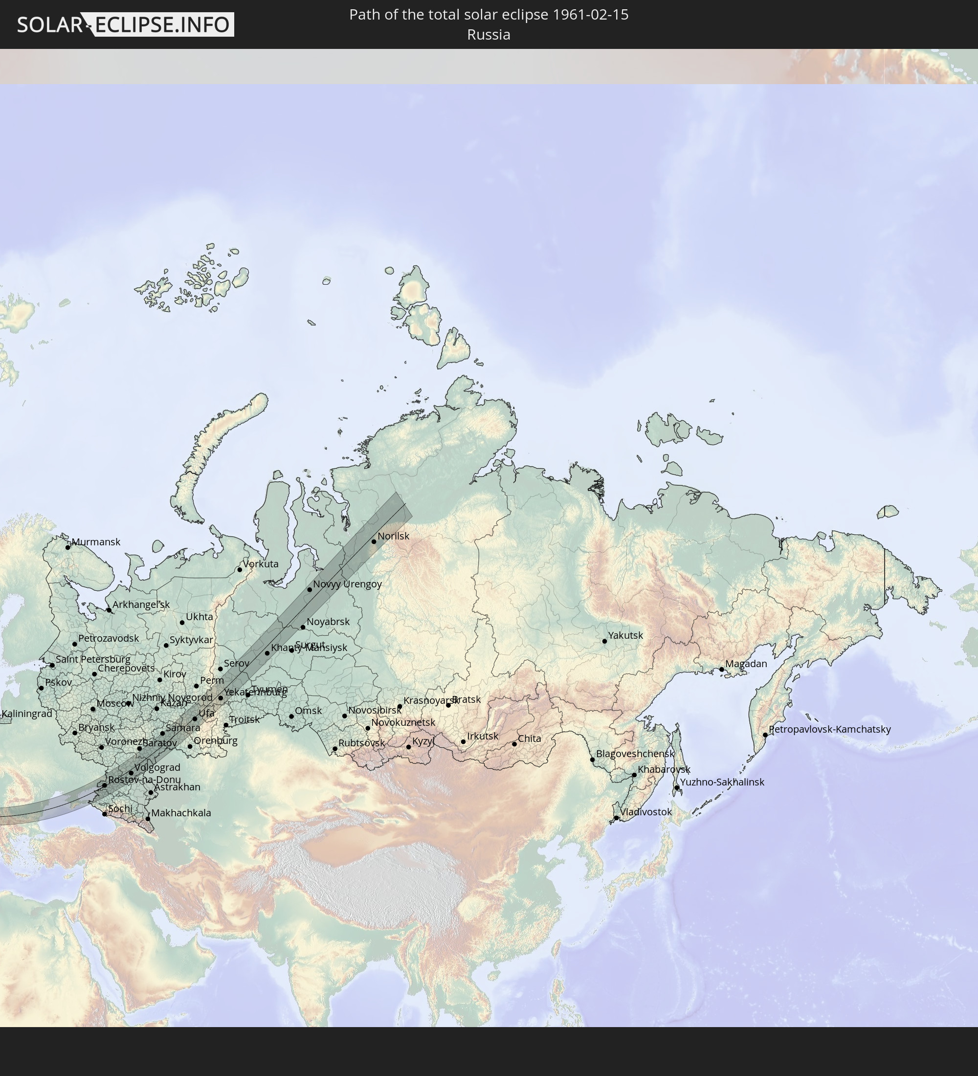 Russland
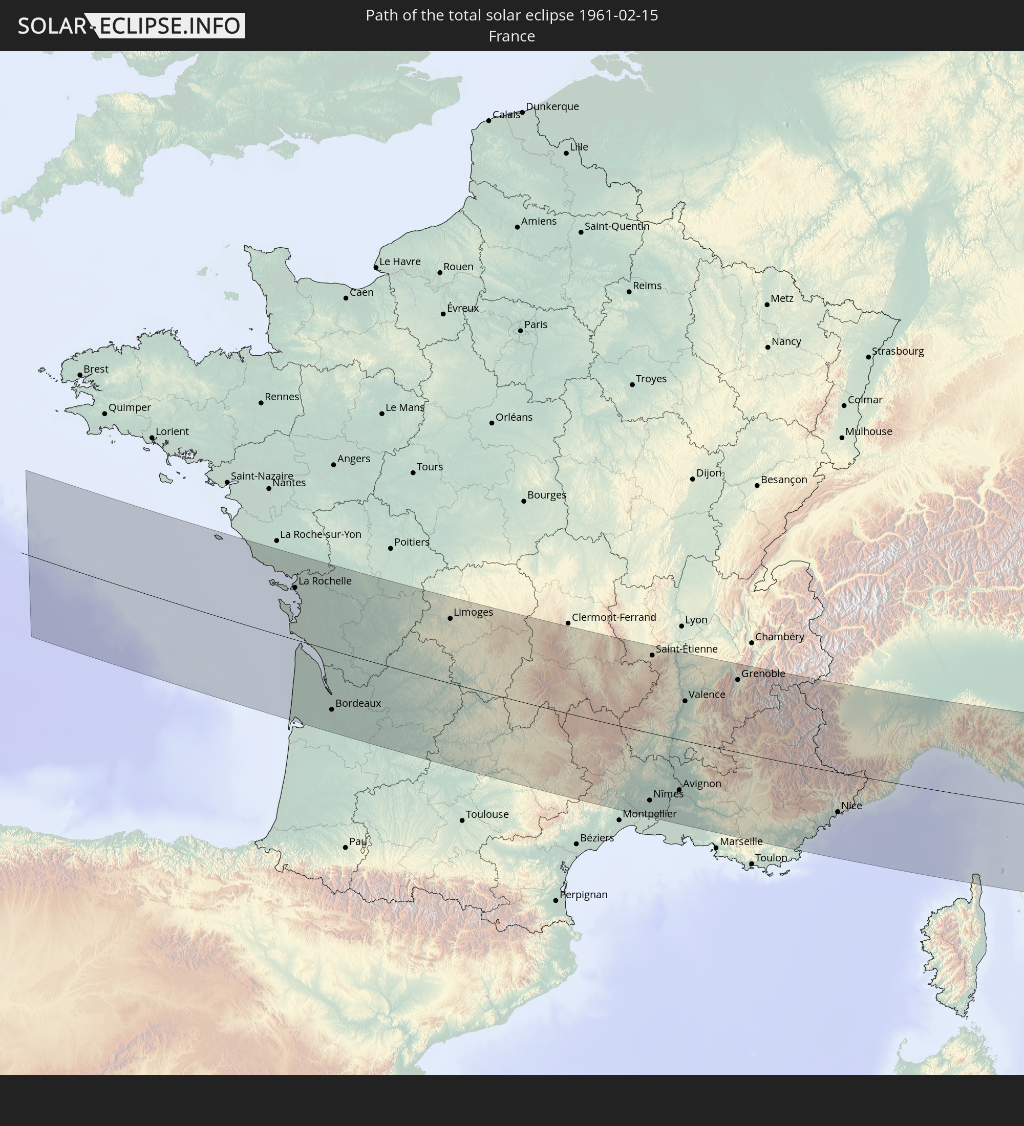 Frankreich
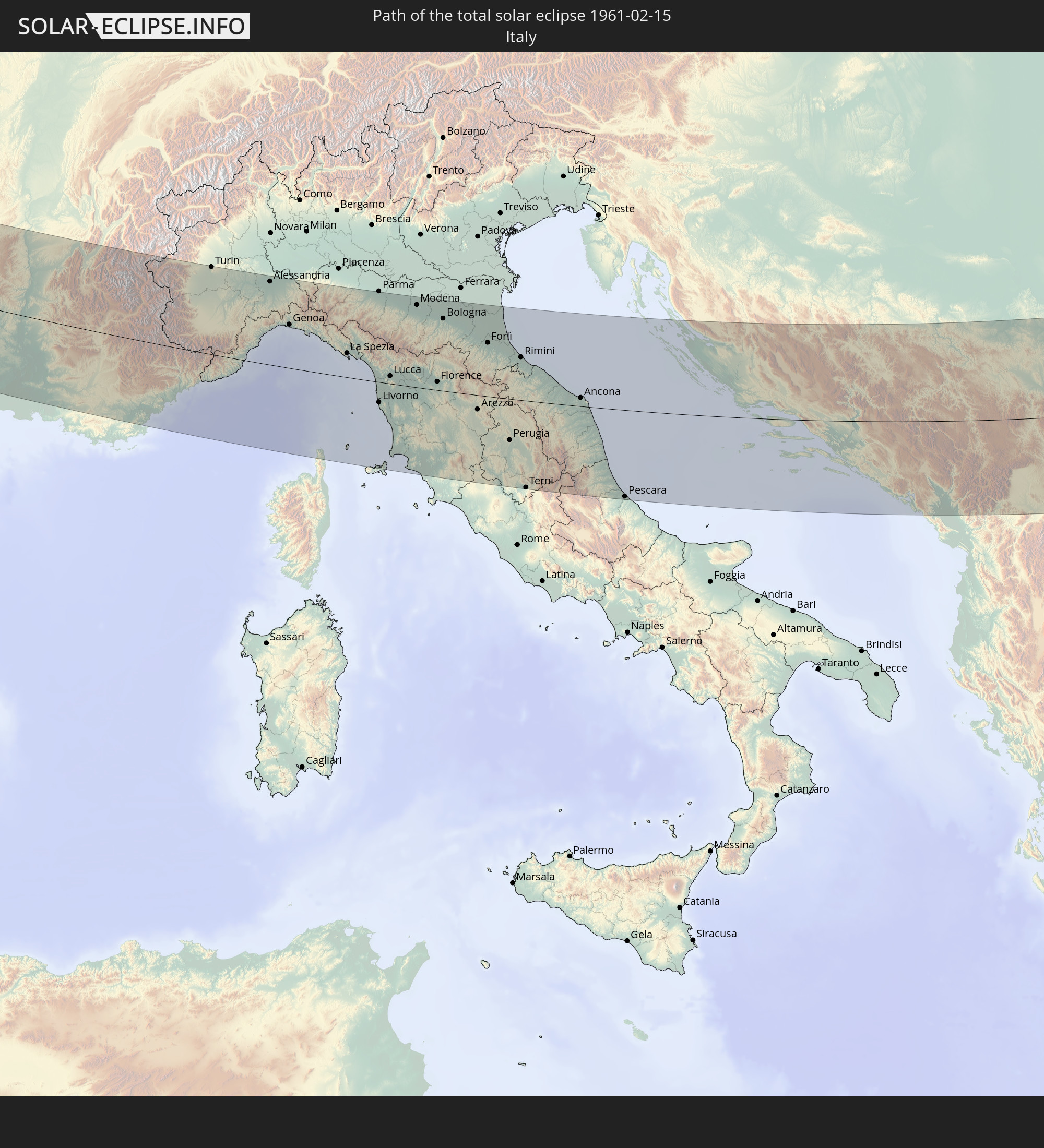 Italien
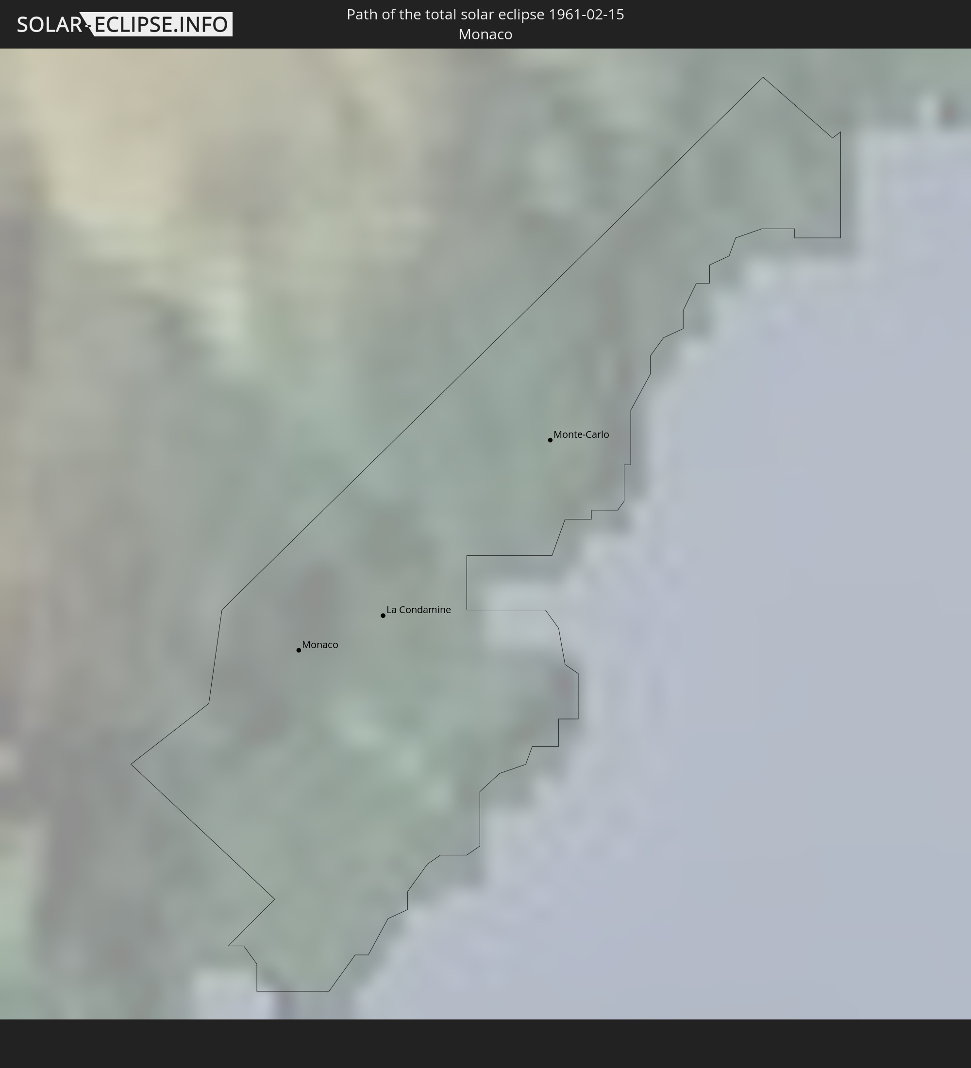 Monaco
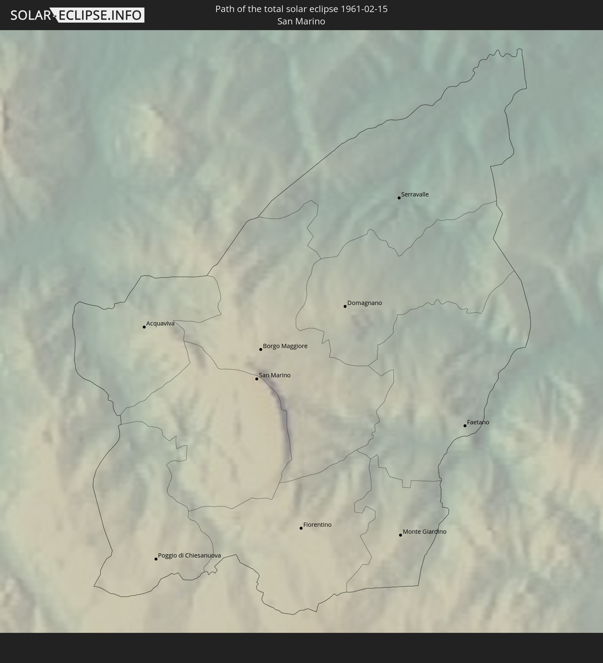 San Marino
 Kroatien
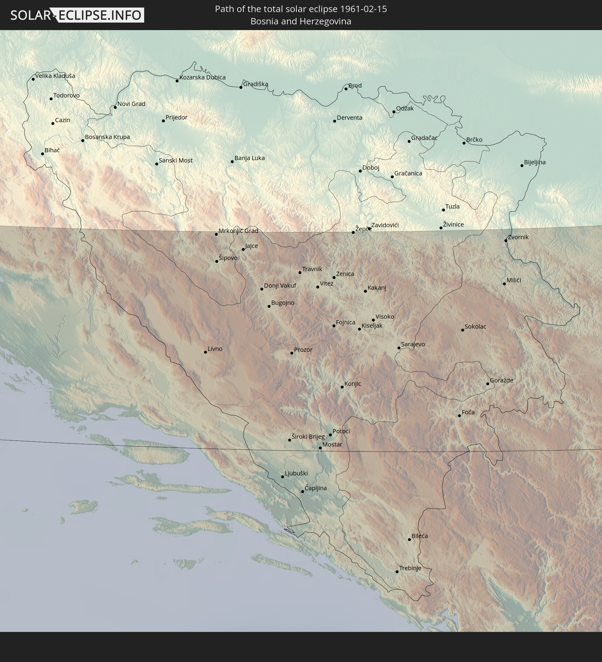 Bosnien und Herzegowina
 Montenegro
 Serbien
 Albanien
 Rumänien
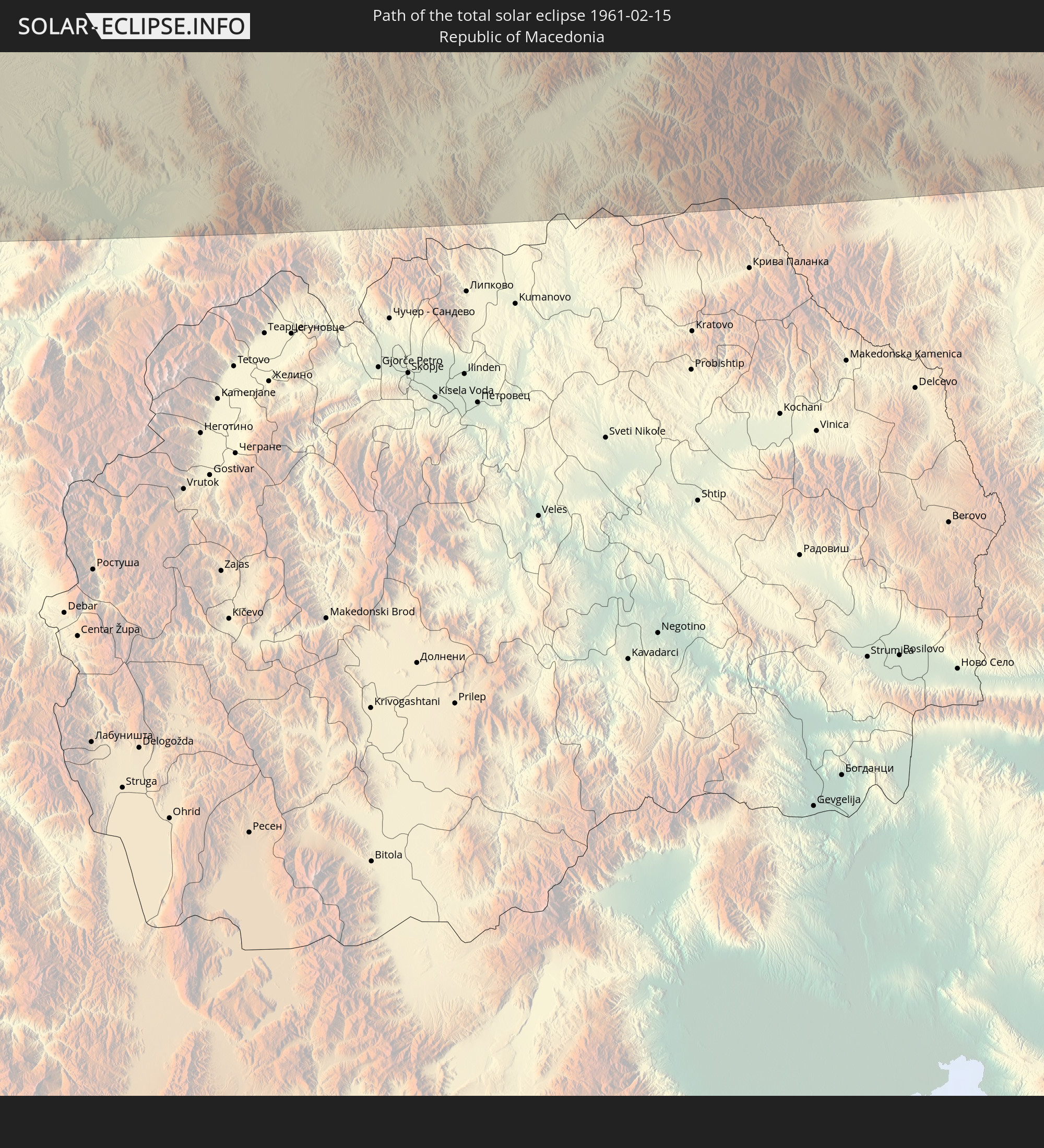 Mazedonien
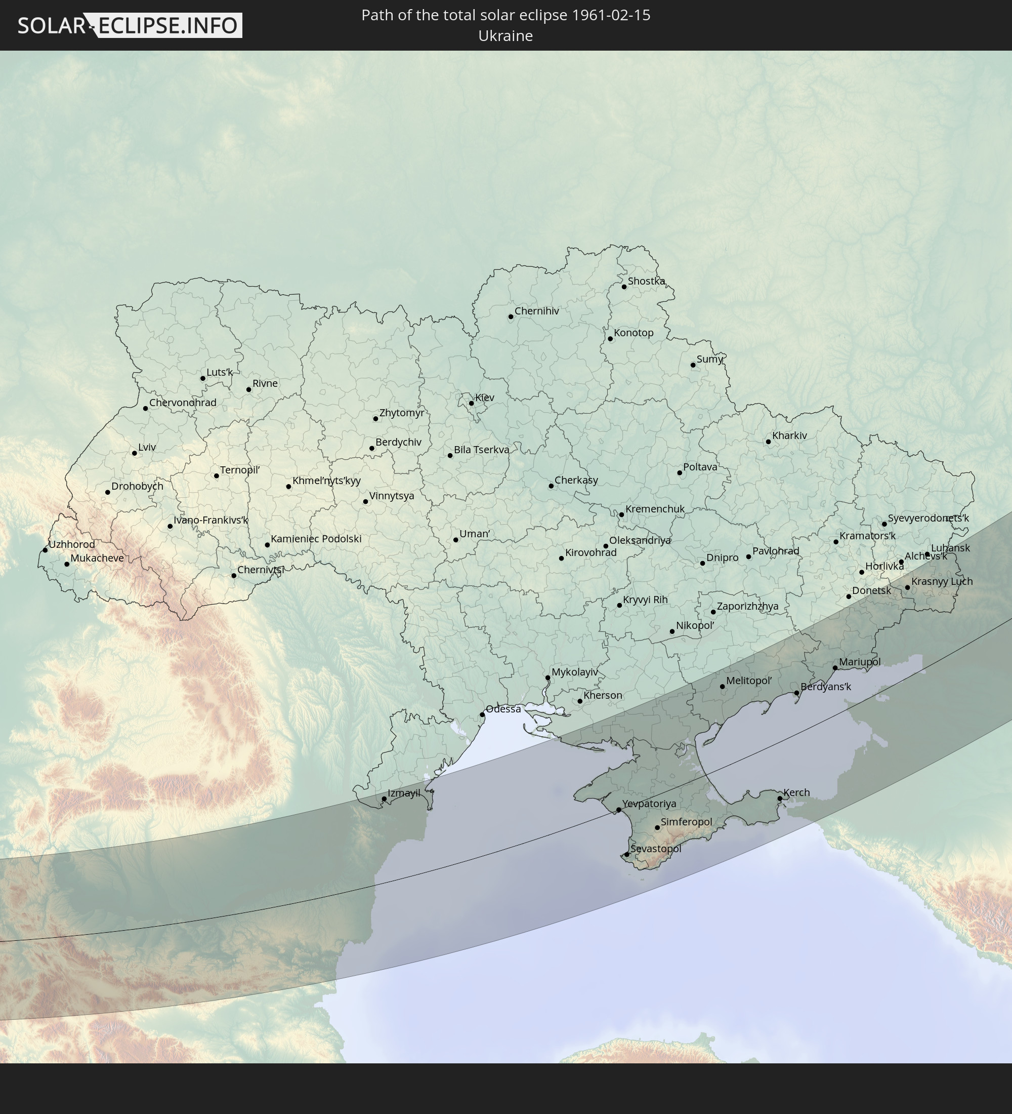 Ukraine
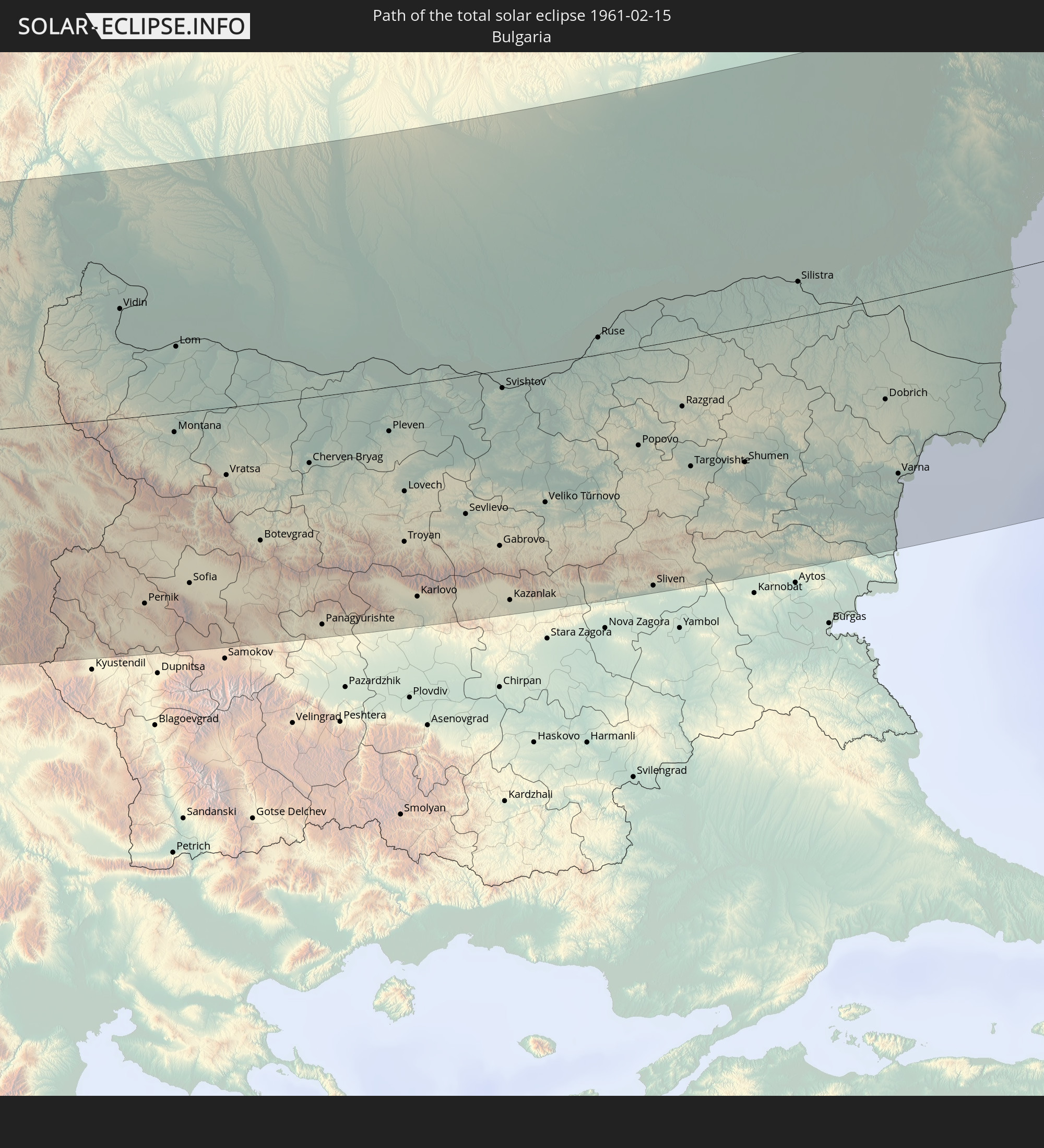 Bulgarien
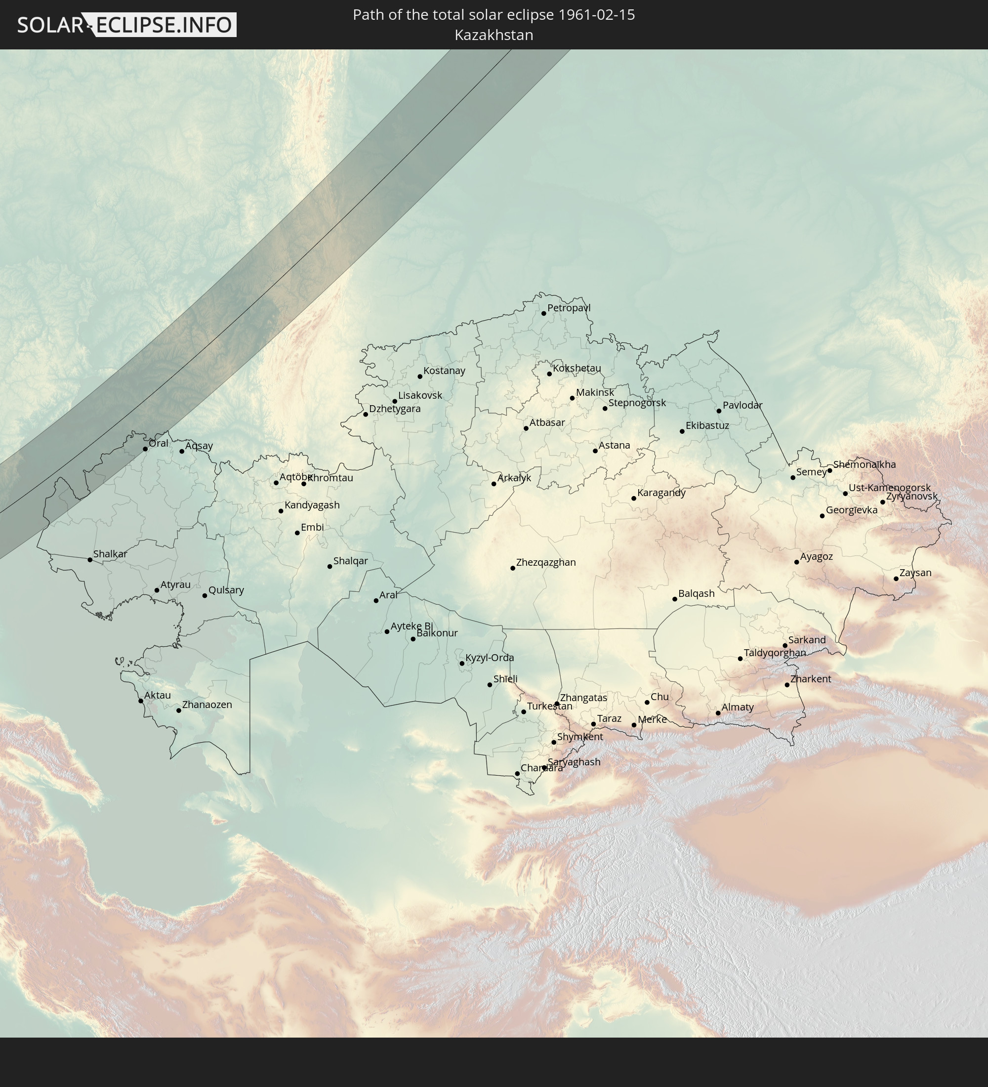 Kasachstan
In den folgenden Ländern ist die Sonnenfinsternis partiell zu sehen
 Russland
 Spanien
 Mauretanien
 Marokko
 Mali
Mali
 Algerien
 Vereinigtes Königreich
 Elfenbeinküste
 Burkina Faso
 Gibraltar
 Frankreich
 Ghana
Ghana
 Guernsey
 Jersey
 Togo
Togo
 Niger
Niger
 Benin
Benin
 Andorra
 Belgien
 Nigeria
 Niederlande
 Norwegen
 Äquatorialguinea
 Luxemburg
 Deutschland
 Schweiz
 Italien
 Monaco
 Tunesien
 Dänemark
 Kamerun
 Gabun
Gabun
 Libyen
 Liechtenstein
 Österreich
 Schweden
 Republik Kongo
 Tschechien
 Demokratische Republik Kongo
 San Marino
 Vatikanstadt
 Slowenien
 Tschad
 Kroatien
 Polen
Polen
 Malta
Malta
 Zentralafrikanische Republik
 Bosnien und Herzegowina
 Ungarn
 Slowakei
 Montenegro
 Serbien
 Albanien
 Åland Islands
 Griechenland
 Rumänien
 Mazedonien
 Finnland
 Litauen
 Lettland
 Estland
 Sudan
Sudan
 Ukraine
 Bulgarien
 Weißrussland
 Ägypten
 Türkei
 Moldawien
 Uganda
 Republik Zypern
 Äthiopien
 Kenia
Kenia
 Staat Palästina
 Israel
 Saudi-Arabien
 Jordanien
 Libanon
 Syrien
 Eritrea
 Irak
Irak
 Georgien
 Somalia
 Dschibuti
 Jemen
Jemen
 Armenien
 Iran
Iran
 Aserbaidschan
 Kasachstan
 Kuwait
 Bahrain
 Katar
Katar
 Vereinigte Arabische Emirate
 Oman
Oman
 Turkmenistan
 Usbekistan
 Afghanistan
 Pakistan
 Tadschikistan
 Indien
 Kirgisistan
 Volksrepublik China
 Nepal
Nepal
 Mongolei
 Bangladesch
 Bhutan
 Myanmar
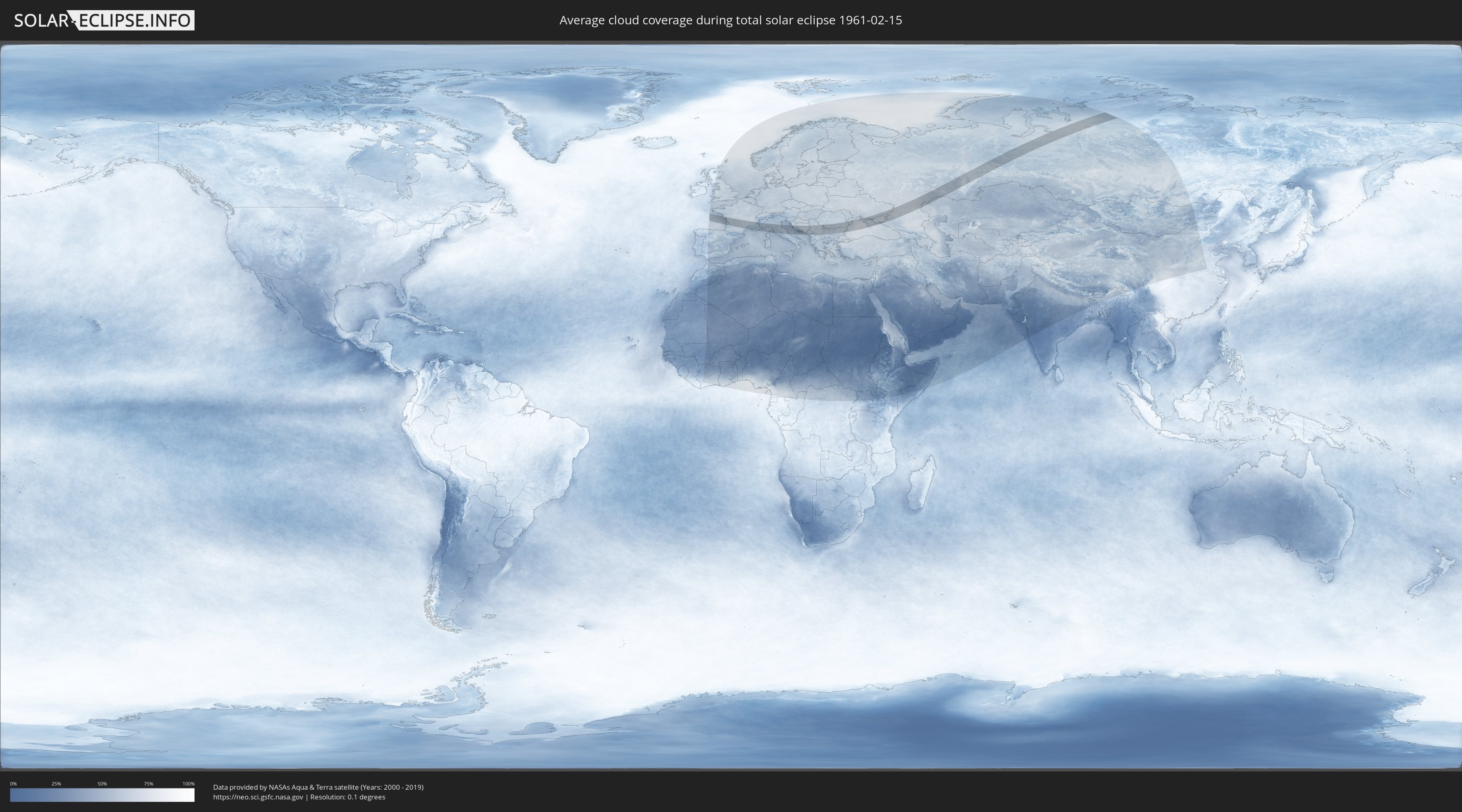
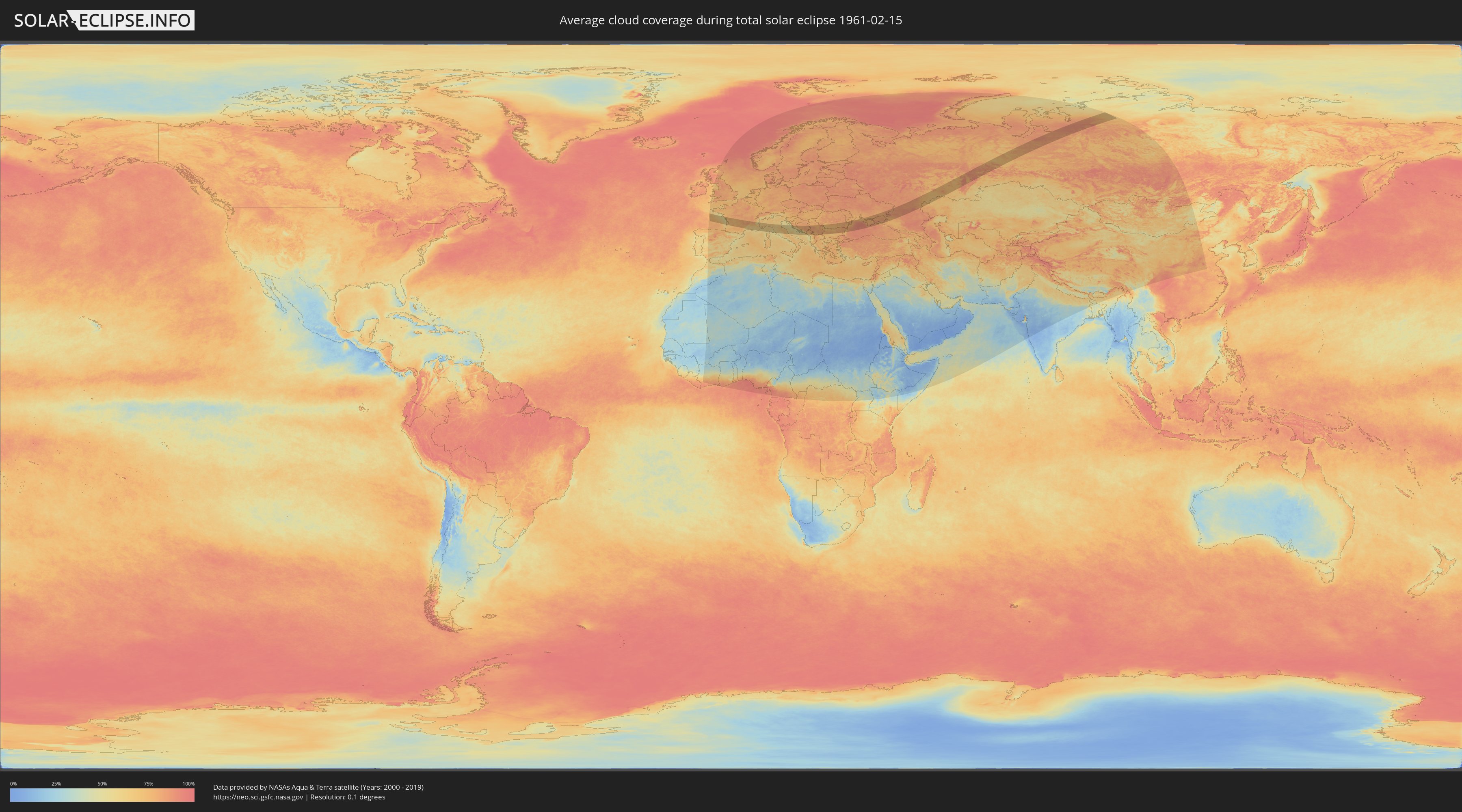
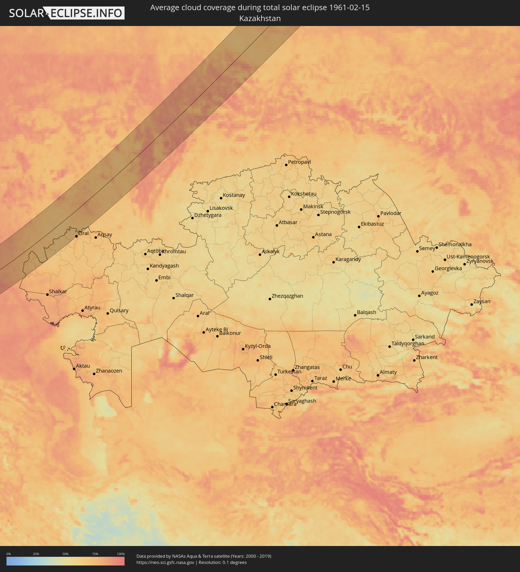
Wie wird das Wetter während der totalen Sonnenfinsternis am 15.02.1961?
Wo ist der beste Ort, um die totale Sonnenfinsternis vom 15.02.1961 zu beobachten?
Die folgenden Karten zeigen die durchschnittliche Bewölkung für den Tag, an dem die totale Sonnenfinsternis
stattfindet. Mit Hilfe der Karten lässt sich der Ort entlang des Finsternispfades eingrenzen,
der die besten Aussichen auf einen klaren wolkenfreien Himmel bietet.
Trotzdem muss man immer lokale Gegenenheiten beachten und sollte sich genau über das Wetter an seinem
gewählten Beobachtungsort informieren.
Die Daten stammen von den beiden NASA-Satelliten
AQUA und TERRA
und wurden über einen Zeitraum von 19 Jahren (2000 - 2019) gemittelt.
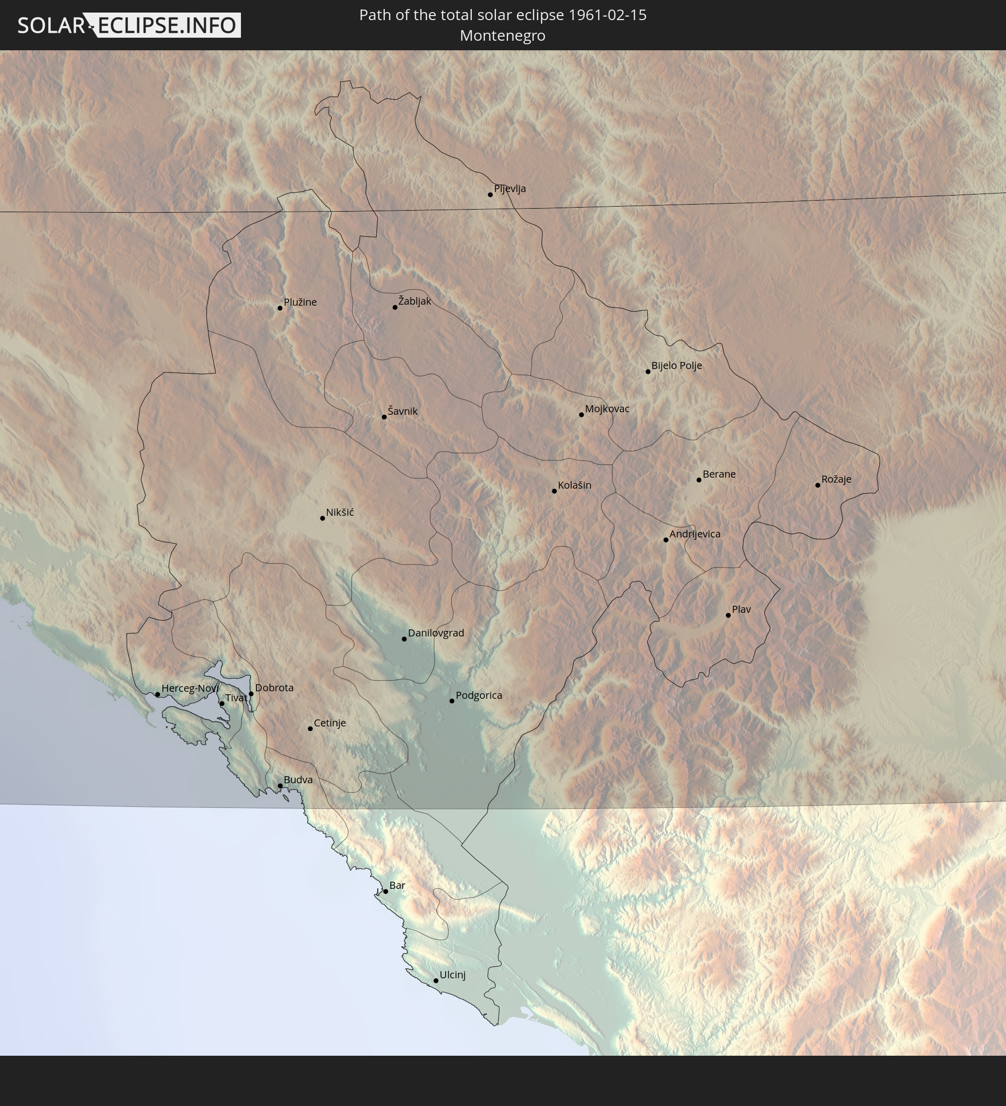
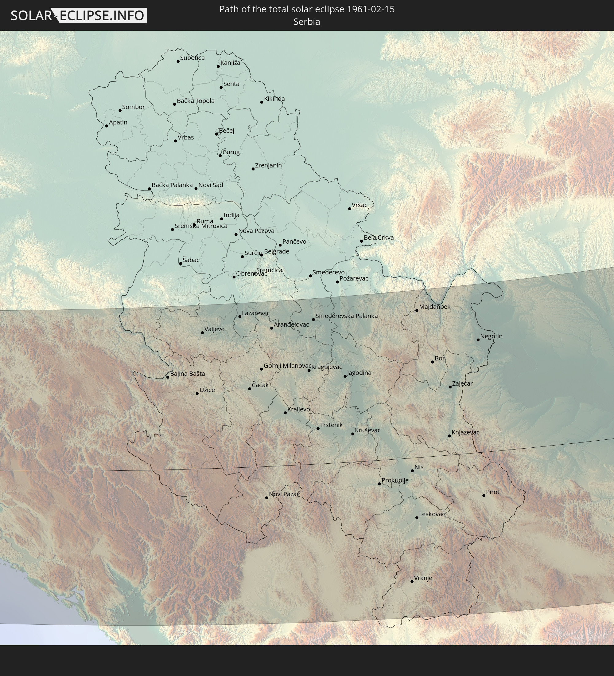
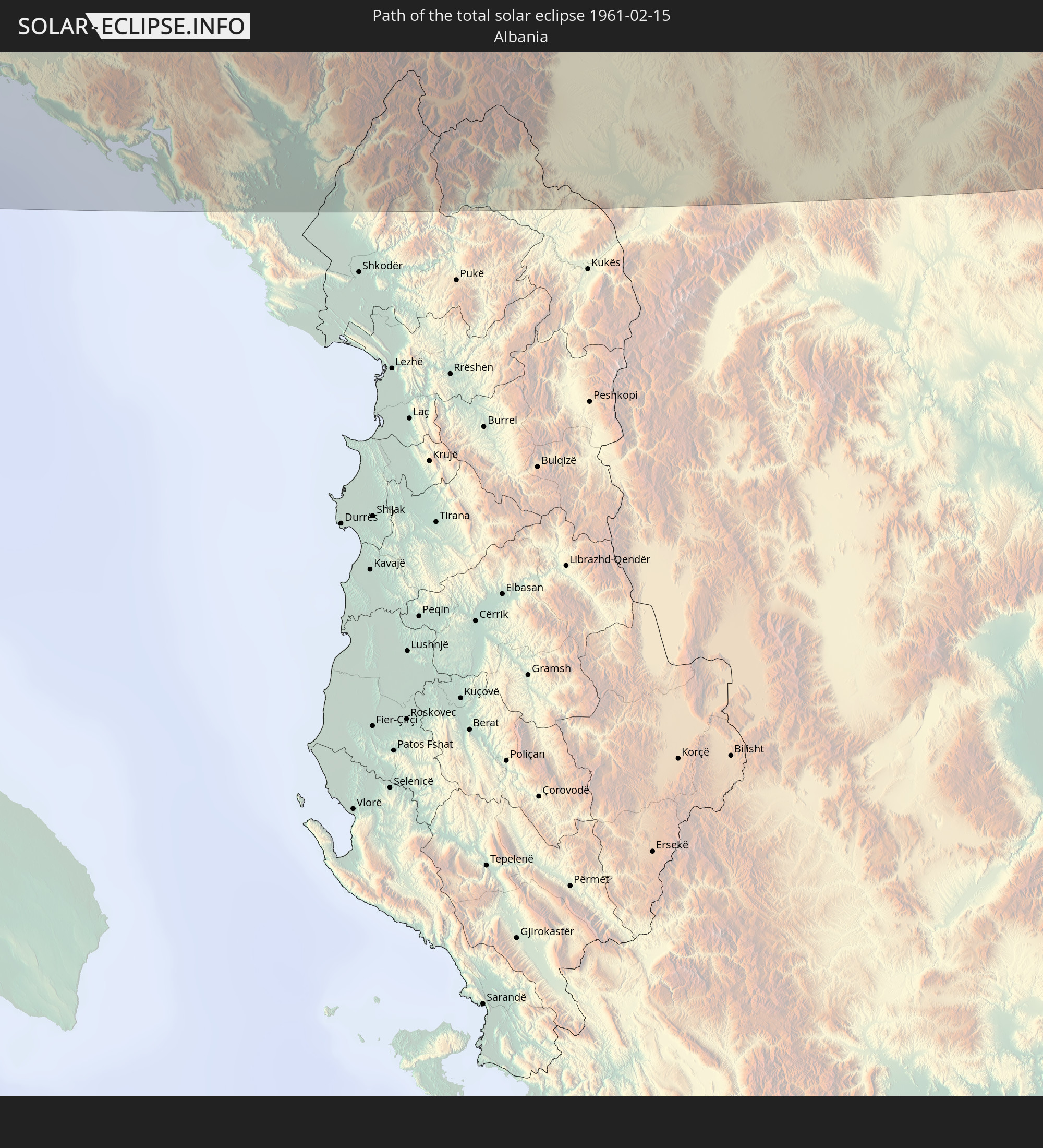
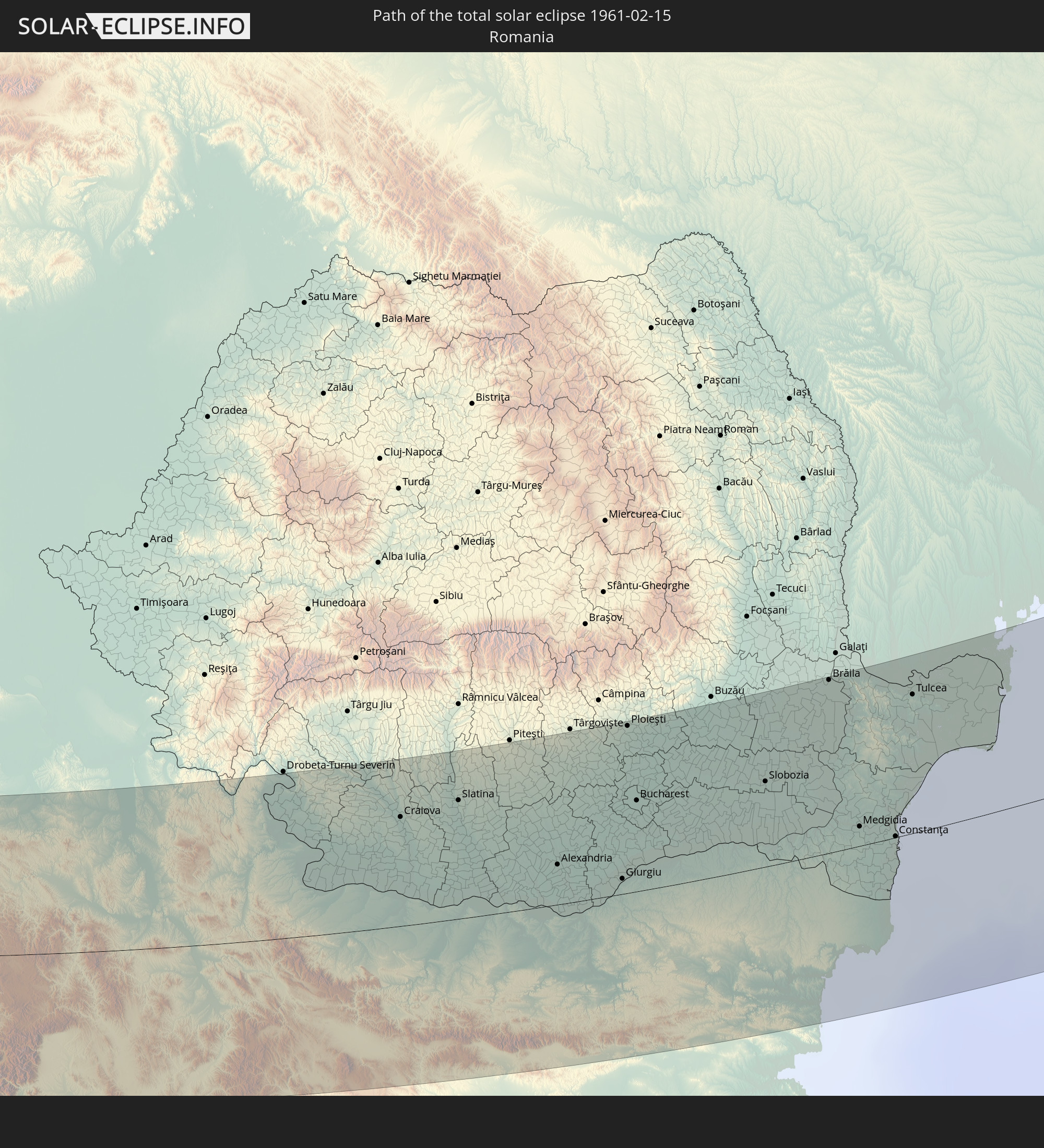
Detaillierte Länderkarten
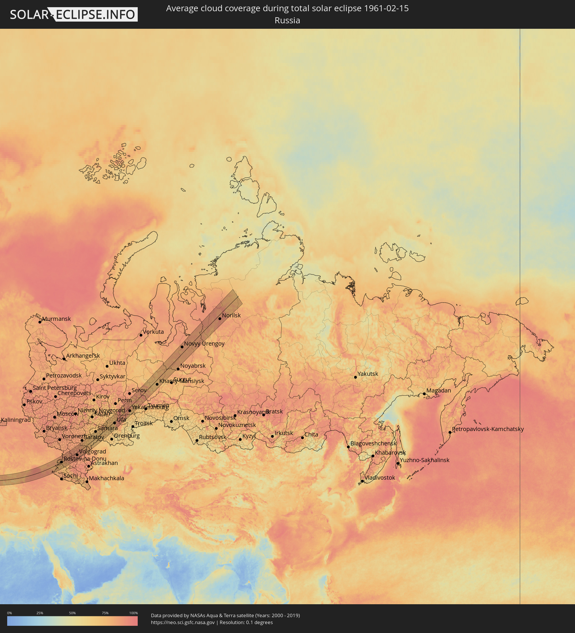 Russland
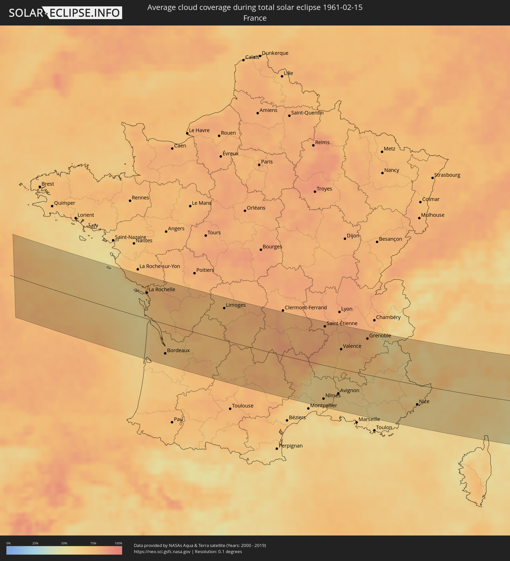 Frankreich
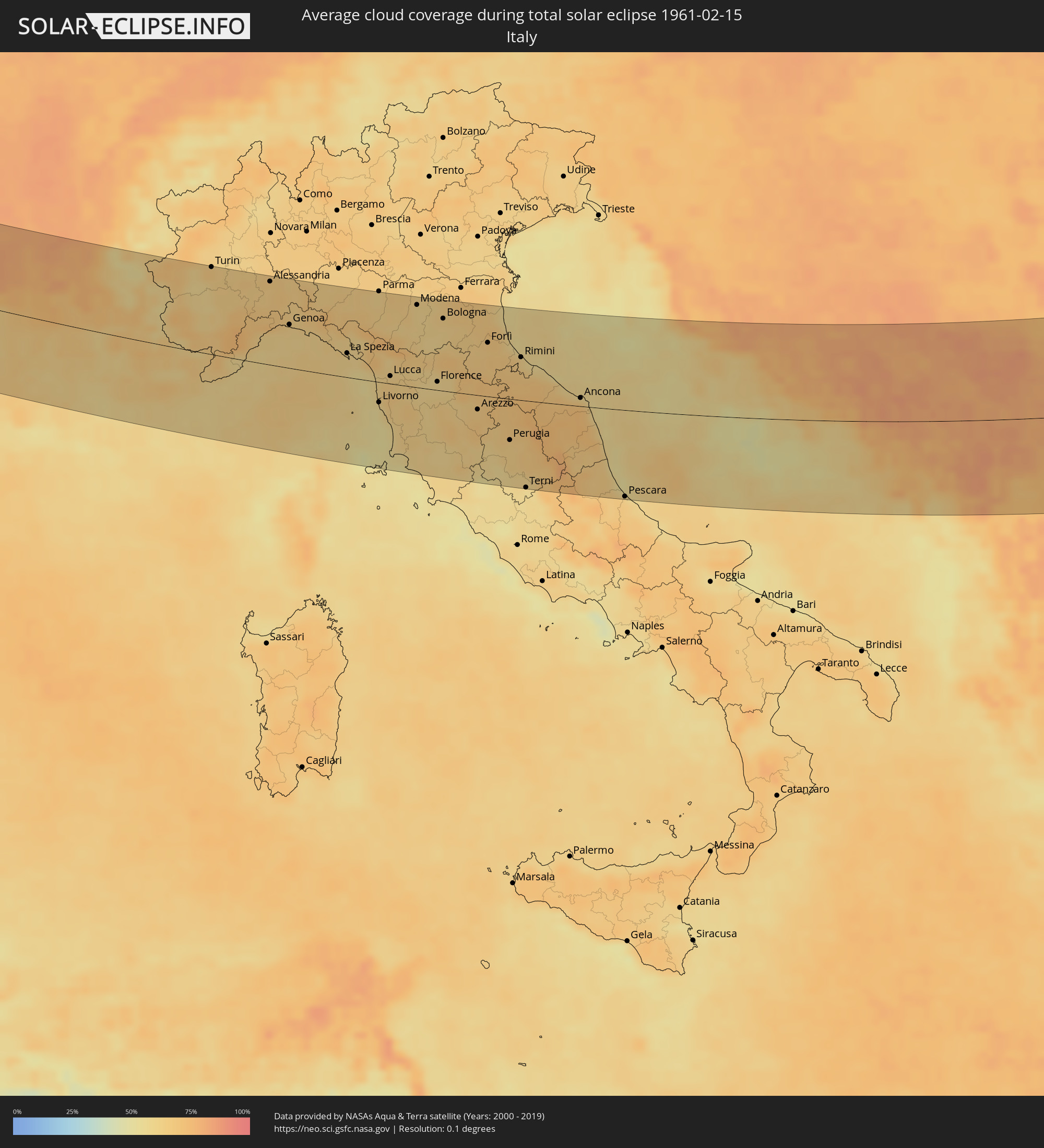 Italien
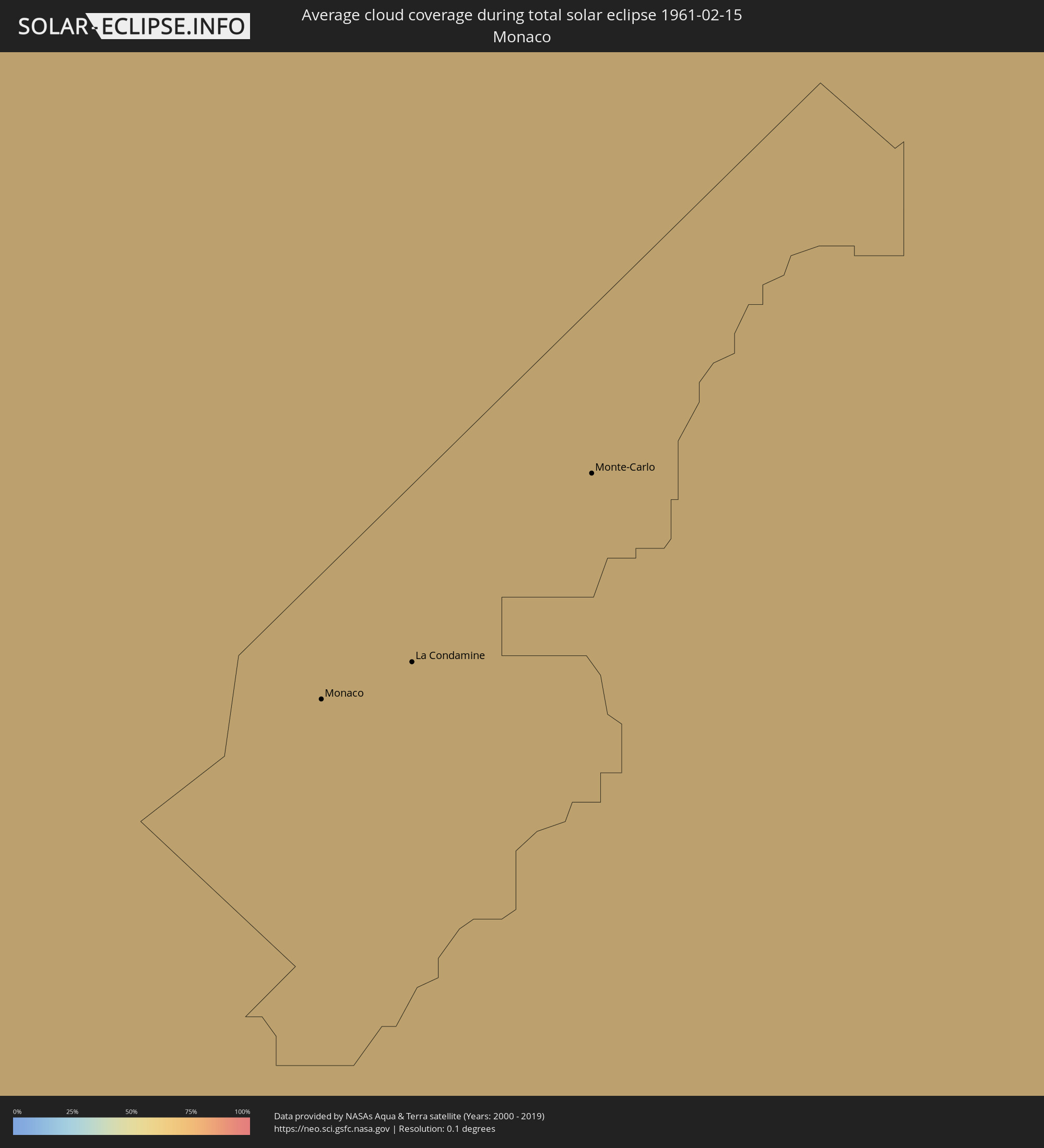 Monaco
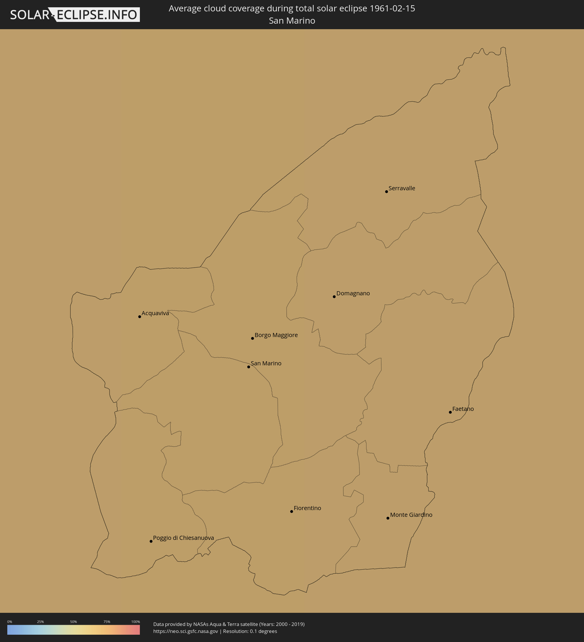 San Marino
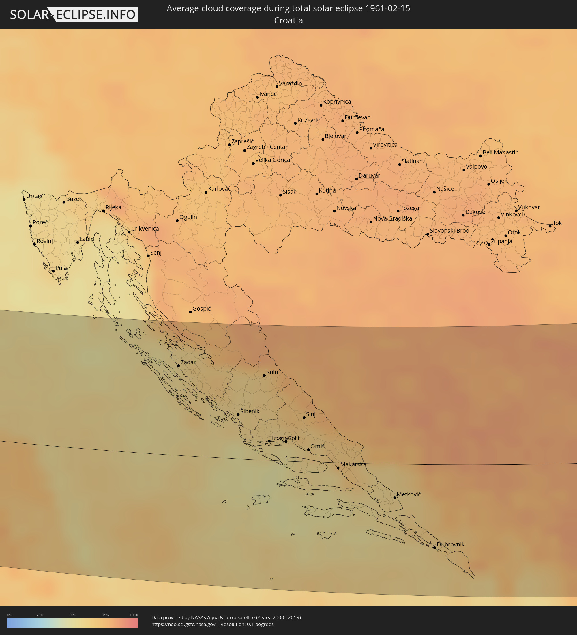 Kroatien
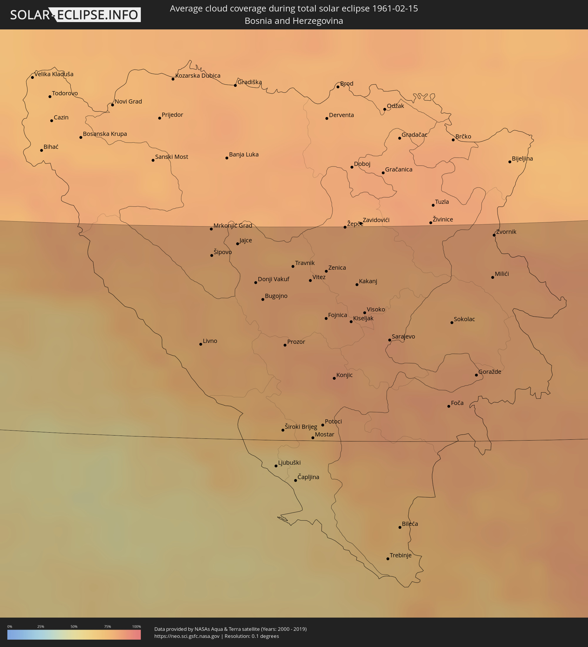 Bosnien und Herzegowina
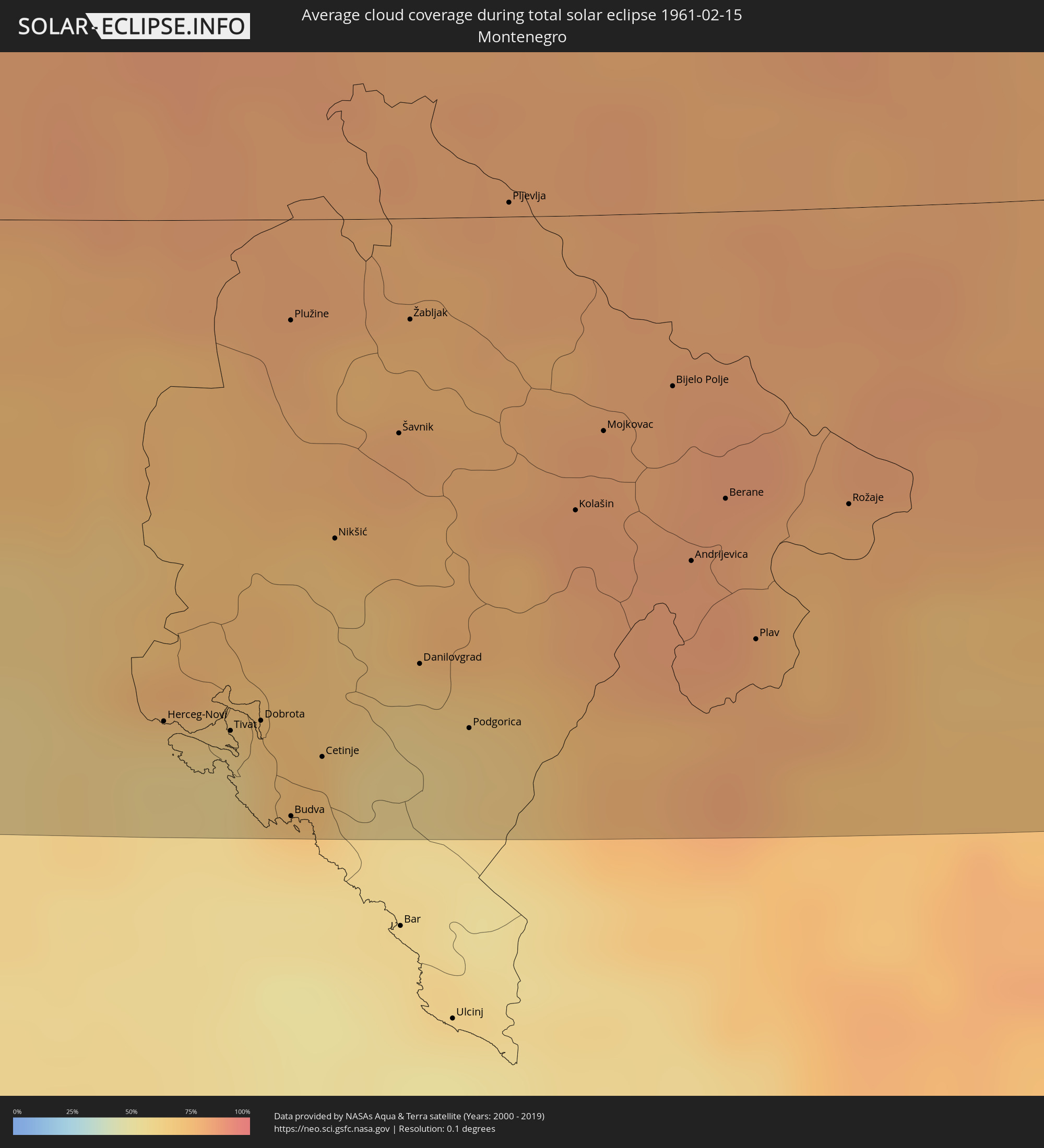 Montenegro
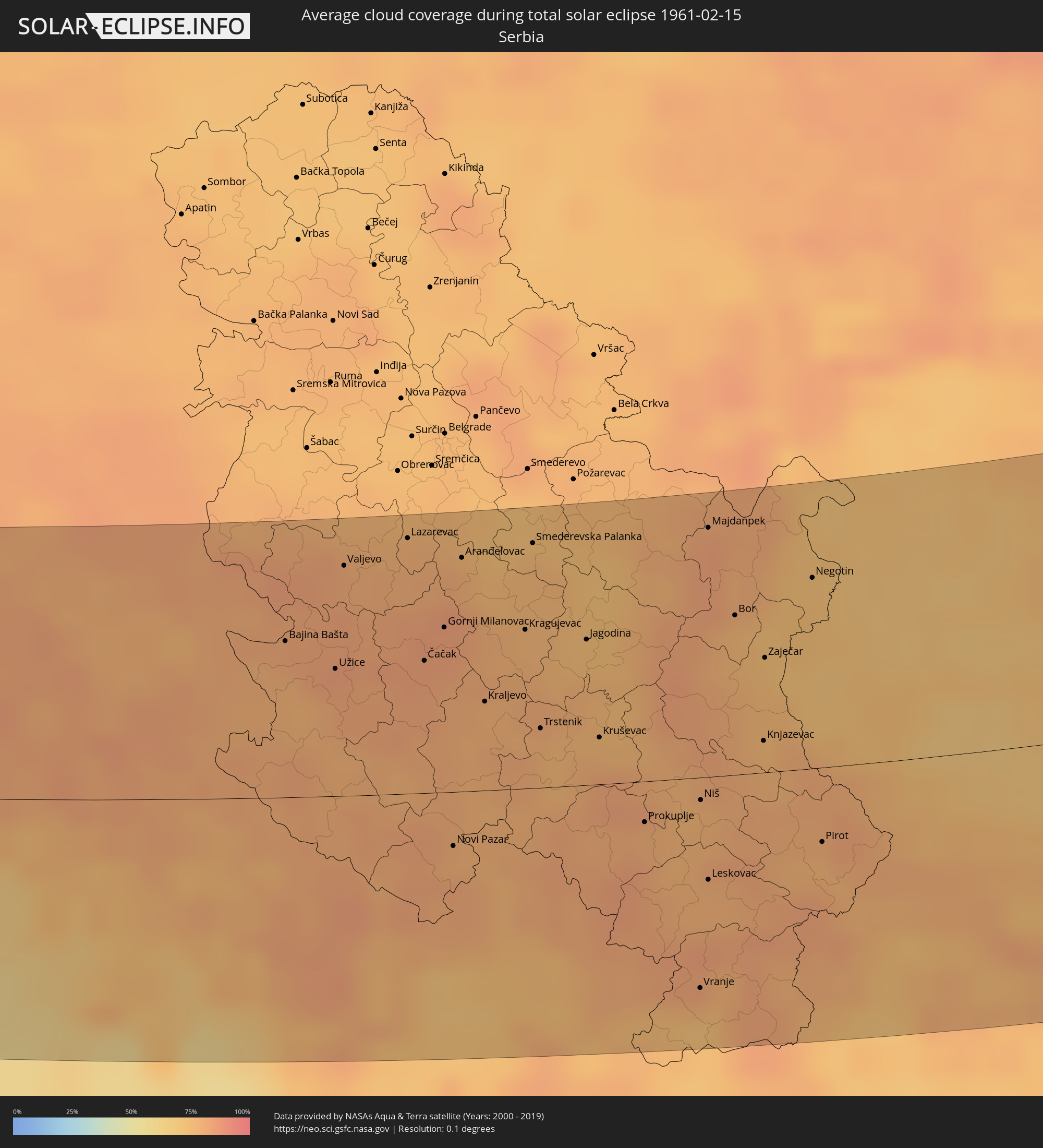 Serbien
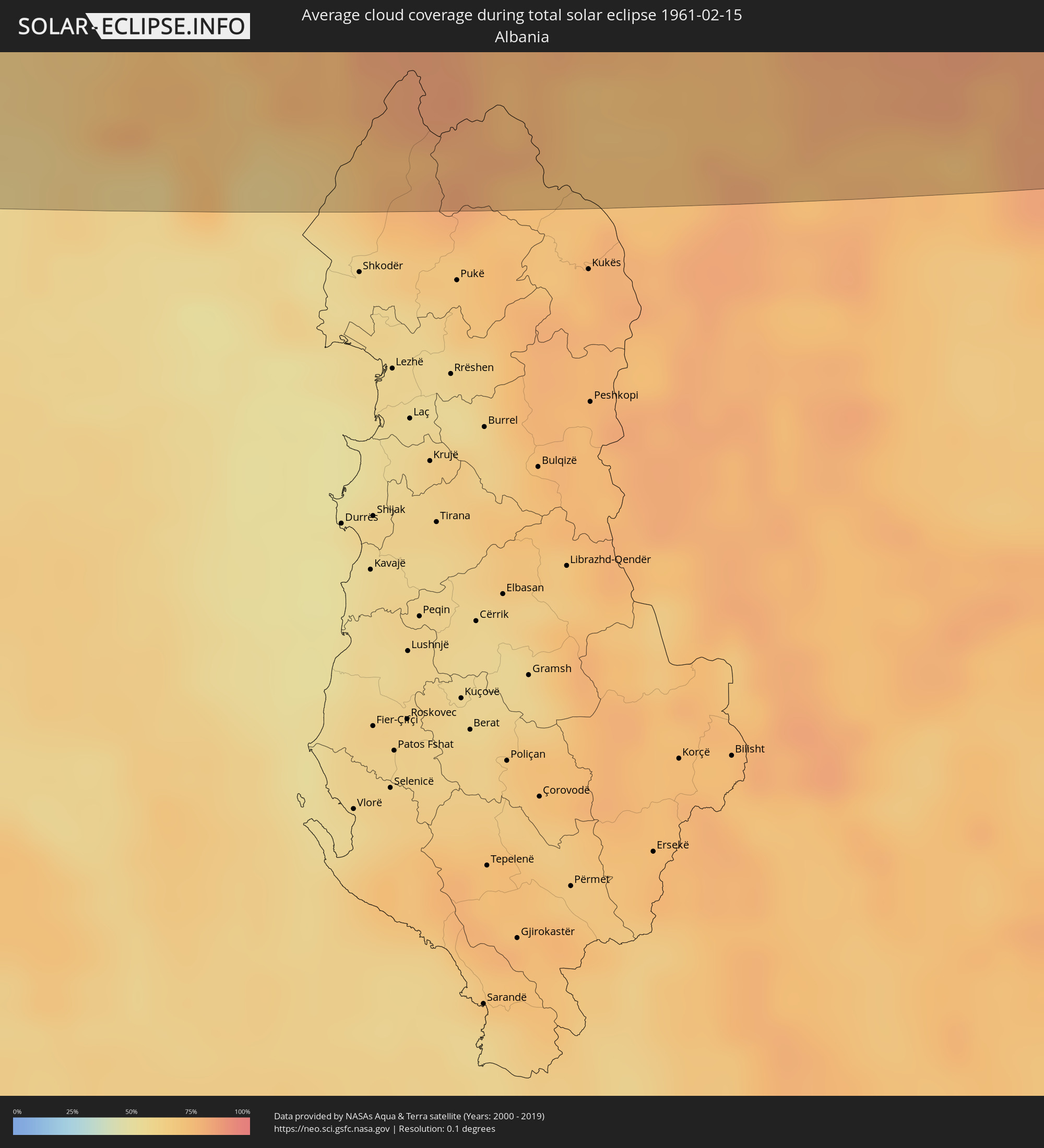 Albanien
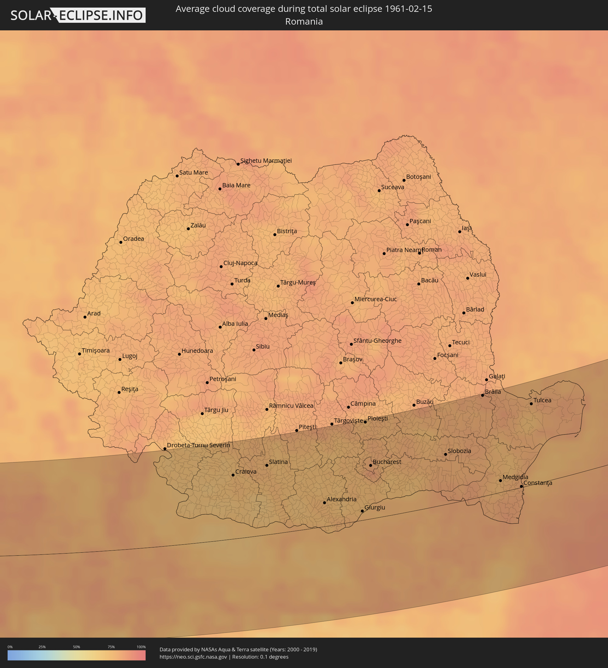 Rumänien
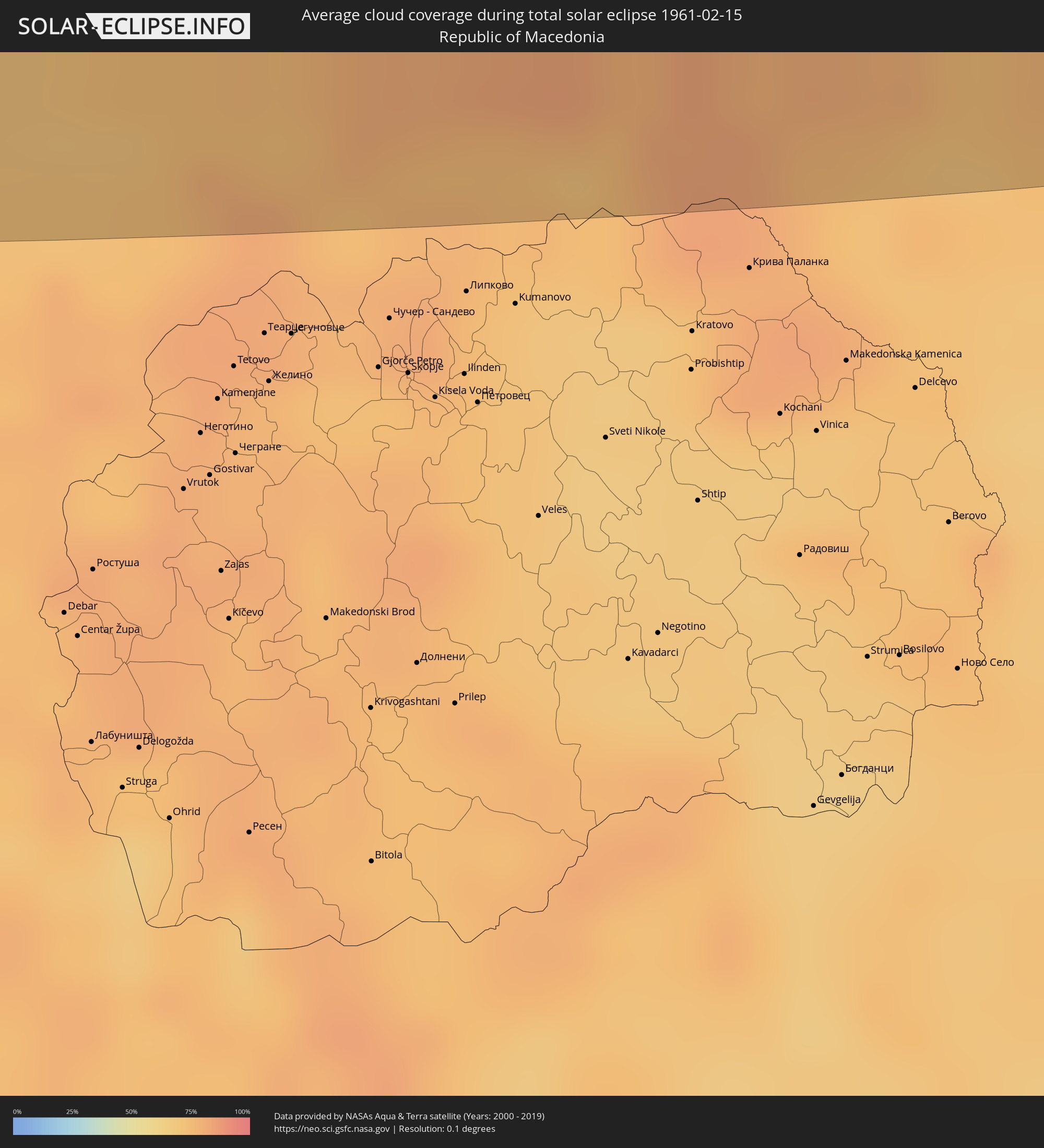 Mazedonien
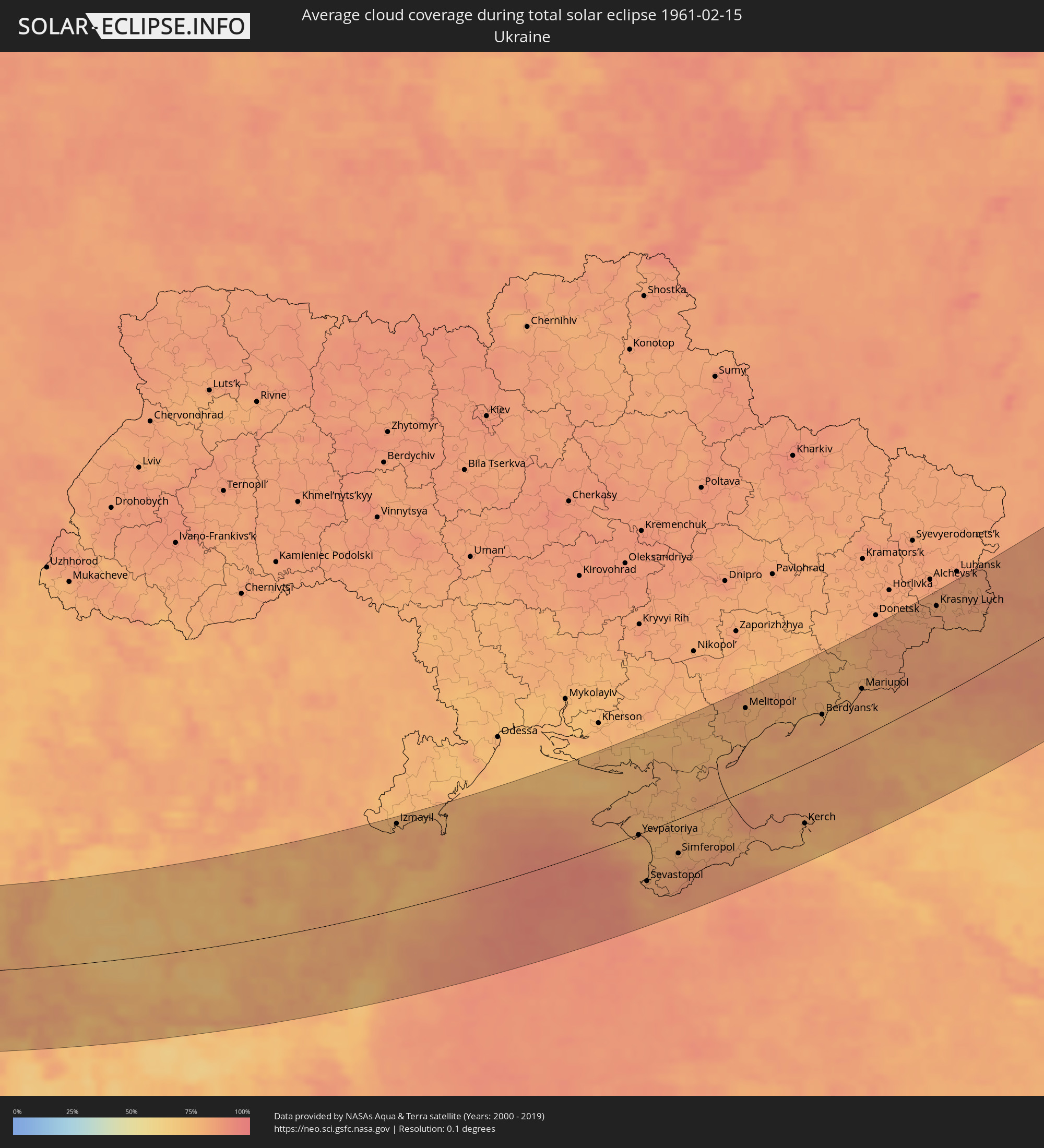 Ukraine
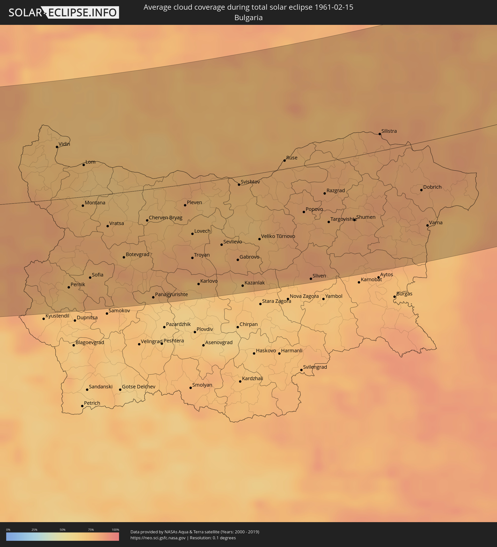 Bulgarien
 Kasachstan
Orte im Finsternispfad
Die nachfolgene Tabelle zeigt Städte und Orte mit mehr als 5.000 Einwohnern, die sich im Finsternispfad befinden. Städte mit mehr als 100.000 Einwohnern sind dick gekennzeichnet. Mit einem Klick auf den Ort öffnet sich eine Detailkarte die die Lage des jeweiligen Ortes zusammen mit dem Verlauf der zentralen Finsternis präsentiert.
| Ort | Typ | Dauer der Verfinsterung | Ortszeit bei maximaler Verfinsterung | Entfernung zur Zentrallinie | Ø Bewölkung |
|
La Rochelle, Nouvelle-Aquitaine
|
total | - | 08:32:16 UTC+01:00 | 60 km | 64% |
|
Bordeaux, Nouvelle-Aquitaine
|
total | - | 08:30:25 UTC+01:00 | 70 km | 69% |
|
Niort, Nouvelle-Aquitaine
|
total | - | 08:32:52 UTC+01:00 | 92 km | 77% |
|
Angoulême, Nouvelle-Aquitaine
|
total | - | 08:32:06 UTC+01:00 | 33 km | 72% |
|
Limoges, Nouvelle-Aquitaine
|
total | - | 08:33:00 UTC+01:00 | 75 km | 76% |
|
Brive-la-Gaillarde, Nouvelle-Aquitaine
|
total | - | 08:32:04 UTC+01:00 | 8 km | 75% |
|
Nîmes, Occitania
|
total | - | 08:31:42 UTC+01:00 | 82 km | 65% |
|
Saint-Étienne, Auvergne-Rhône-Alpes
|
total | - | 08:34:17 UTC+01:00 | 93 km | 80% |
|
Arles, Provence-Alpes-Côte d'Azur
|
total | - | 08:31:38 UTC+01:00 | 94 km | 67% |
|
Avignon, Provence-Alpes-Côte d'Azur
|
total | - | 08:32:11 UTC+01:00 | 61 km | 65% |
|
Valence, Auvergne-Rhône-Alpes
|
total | - | 08:33:50 UTC+01:00 | 47 km | 75% |
|
Aix-en-Provence, Provence-Alpes-Côte d'Azur
|
total | - | 08:31:58 UTC+01:00 | 96 km | 63% |
|
Grenoble, Auvergne-Rhône-Alpes
|
total | - | 08:34:46 UTC+01:00 | 87 km | 78% |
|
Fréjus, Provence-Alpes-Côte d'Azur
|
total | - | 08:32:44 UTC+01:00 | 86 km | 59% |
|
Antibes, Provence-Alpes-Côte d'Azur
|
total | - | 08:33:14 UTC+01:00 | 66 km | 61% |
|
Nice, Provence-Alpes-Côte d'Azur
|
total | - | 08:33:34 UTC+01:00 | 49 km | 61% |
|
Monaco
|
total | - | 08:33:43 UTC+01:00 | 43 km | 59% |
|
La Condamine
|
total | - | 08:33:44 UTC+01:00 | 43 km | 59% |
|
Monte-Carlo
|
total | - | 08:33:45 UTC+01:00 | 42 km | 59% |
|
Turin, Piedmont
|
total | - | 08:36:04 UTC+01:00 | 107 km | 67% |
|
Genoa, Liguria
|
total | - | 08:36:00 UTC+01:00 | 54 km | 61% |
|
La Spezia, Liguria
|
total | - | 08:36:15 UTC+01:00 | 30 km | 61% |
|
Livorno, Tuscany
|
total | - | 08:35:47 UTC+01:00 | 26 km | 54% |
|
Lucca, Tuscany
|
total | - | 08:36:25 UTC+01:00 | 10 km | 65% |
|
Reggio nell'Emilia, Emilia-Romagna
|
total | - | 08:37:53 UTC+01:00 | 105 km | 64% |
|
Modena, Emilia-Romagna
|
total | - | 08:38:03 UTC+01:00 | 103 km | 61% |
|
Prato, Tuscany
|
total | - | 08:36:59 UTC+01:00 | 20 km | 61% |
|
Florence, Tuscany
|
total | - | 08:36:58 UTC+01:00 | 11 km | 59% |
|
Bologna, Emilia-Romagna
|
total | - | 08:38:10 UTC+01:00 | 90 km | 62% |
|
Forlì, Emilia-Romagna
|
total | - | 08:38:23 UTC+01:00 | 67 km | 65% |
|
Perugia, Umbria
|
total | - | 08:36:58 UTC+01:00 | 52 km | 63% |
|
Acquaviva, Acquaviva
|
total | - | 08:38:18 UTC+01:00 | 40 km | 68% |
|
Poggio di Chiesanuova, Chiesanuova
|
total | - | 08:38:14 UTC+01:00 | 36 km | 68% |
|
San Marino, San Marino
|
total | - | 08:38:18 UTC+01:00 | 40 km | 68% |
|
Borgo Maggiore, Borgo Maggiore
|
total | - | 08:38:19 UTC+01:00 | 40 km | 68% |
|
Fiorentino, Fiorentino
|
total | - | 08:38:16 UTC+01:00 | 37 km | 68% |
|
Domagnano, Domagnano
|
total | - | 08:38:21 UTC+01:00 | 41 km | 68% |
|
Serravalle, Serravalle
|
total | - | 08:38:23 UTC+01:00 | 44 km | 67% |
|
Monte Giardino, Montegiardino
|
total | - | 08:38:18 UTC+01:00 | 37 km | 68% |
|
Faetano, Faetano
|
total | - | 08:38:20 UTC+01:00 | 39 km | 68% |
|
Rimini, Emilia-Romagna
|
total | - | 08:38:36 UTC+01:00 | 54 km | 62% |
|
Terni, Umbria
|
total | - | 08:36:21 UTC+01:00 | 111 km | 57% |
|
Ancona, The Marches
|
total | - | 08:38:46 UTC+01:00 | 10 km | 68% |
|
Pescara, Abruzzo
|
total | - | 08:37:42 UTC+01:00 | 111 km | 63% |
|
Zadar, Zadarska
|
total | - | 08:41:20 UTC+01:00 | 80 km | 56% |
|
Vodice, Šibensko-Kniniska
|
total | - | 08:41:20 UTC+01:00 | 42 km | 59% |
|
Šibenik, Šibensko-Kniniska
|
total | - | 08:41:24 UTC+01:00 | 39 km | 59% |
|
Knin, Šibensko-Kniniska
|
total | - | 08:42:12 UTC+01:00 | 75 km | 62% |
|
Trogir, Splitsko-Dalmatinska
|
total | - | 08:41:27 UTC+01:00 | 17 km | 54% |
|
Kaštel Novi, Splitsko-Dalmatinska
|
total | - | 08:41:35 UTC+01:00 | 21 km | 60% |
|
Kaštel Stari, Splitsko-Dalmatinska
|
total | - | 08:41:36 UTC+01:00 | 21 km | 60% |
|
Kaštel Lukšić, Splitsko-Dalmatinska
|
total | - | 08:41:38 UTC+01:00 | 22 km | 60% |
|
Split, Splitsko-Dalmatinska
|
total | - | 08:41:38 UTC+01:00 | 17 km | 53% |
|
Solin, Splitsko-Dalmatinska
|
total | - | 08:41:45 UTC+01:00 | 21 km | 55% |
|
Podstrana, Splitsko-Dalmatinska
|
total | - | 08:41:43 UTC+01:00 | 15 km | 59% |
|
Sinj, Splitsko-Dalmatinska
|
total | - | 08:42:09 UTC+01:00 | 39 km | 63% |
|
Omiš, Splitsko-Dalmatinska
|
total | - | 08:41:48 UTC+01:00 | 11 km | 57% |
|
Livno, Federation of Bosnia and Herzegovina
|
total | - | 08:42:44 UTC+01:00 | 54 km | 76% |
|
Makarska, Splitsko-Dalmatinska
|
total | - | 08:41:56 UTC+01:00 | 5 km | 59% |
|
Mrkonjić Grad, Republic of Srspka
|
total | - | 08:43:44 UTC+01:00 | 120 km | 78% |
|
Šipovo, Republic of Srspka
|
total | - | 08:43:31 UTC+01:00 | 105 km | 77% |
|
Bugojno, Federation of Bosnia and Herzegovina
|
total | - | 08:43:35 UTC+01:00 | 80 km | 81% |
|
Prozor, Federation of Bosnia and Herzegovina
|
total | - | 08:43:23 UTC+01:00 | 55 km | 81% |
|
Metković, Dubrovačko-Neretvanska
|
total | - | 08:42:16 UTC+01:00 | 31 km | 60% |
|
Travnik, Federation of Bosnia and Herzegovina
|
total | - | 08:44:04 UTC+01:00 | 100 km | 81% |
|
Mostar, Federation of Bosnia and Herzegovina
|
total | - | 08:42:53 UTC+01:00 | 1 km | 64% |
|
Zenica, Federation of Bosnia and Herzegovina
|
total | - | 08:44:18 UTC+01:00 | 97 km | 81% |
|
Konjic, Federation of Bosnia and Herzegovina
|
total | - | 08:43:31 UTC+01:00 | 36 km | 82% |
|
Dubrovnik, Dubrovačko-Neretvanska
|
total | - | 08:42:09 UTC+01:00 | 76 km | 60% |
|
Kakanj, Federation of Bosnia and Herzegovina
|
total | - | 08:44:26 UTC+01:00 | 90 km | 82% |
|
Visoko, Federation of Bosnia and Herzegovina
|
total | - | 08:44:17 UTC+01:00 | 74 km | 82% |
|
Trebinje, Republic of Srspka
|
total | - | 08:42:32 UTC+01:00 | 68 km | 65% |
|
Sarajevo, Federation of Bosnia and Herzegovina
|
total | - | 08:44:16 UTC+01:00 | 58 km | 82% |
|
Bileća, Republic of Srspka
|
total | - | 08:42:53 UTC+01:00 | 50 km | 68% |
|
Herceg-Novi, Herceg Novi
|
total | - | 08:42:22 UTC+01:00 | 97 km | 66% |
|
Tivat, Tivat
|
total | - | 08:42:31 UTC+01:00 | 99 km | 59% |
|
Kotor, Kotor
|
total | - | 08:42:35 UTC+01:00 | 101 km | 70% |
|
Dobrota
|
total | - | 08:42:38 UTC+01:00 | 97 km | 73% |
|
Foča, Republic of Srspka
|
total | - | 08:44:14 UTC+01:00 | 20 km | 80% |
|
Budva, Budva
|
total | - | 08:42:28 UTC+01:00 | 116 km | 62% |
|
Cetinje, Cetinje
|
total | - | 08:42:42 UTC+01:00 | 104 km | 73% |
|
Nikšić, Opština Nikšić
|
total | - | 08:43:19 UTC+01:00 | 62 km | 70% |
|
Goražde, Federation of Bosnia and Herzegovina
|
total | - | 08:44:42 UTC+01:00 | 38 km | 81% |
|
Danilovgrad, Danilovgrad
|
total | - | 08:43:13 UTC+01:00 | 86 km | 65% |
|
Podgorica, Podgorica
|
total | - | 08:43:11 UTC+01:00 | 99 km | 63% |
|
Pljevlja, Pljevlja
|
total | - | 08:44:41 UTC+01:00 | 3 km | 80% |
|
Kolašin, Opština Kolašin
|
total | - | 08:44:04 UTC+01:00 | 57 km | 82% |
|
Mojkovac, Mojkovac
|
total | - | 08:44:21 UTC+01:00 | 42 km | 81% |
|
Bijelo Polje, Bijelo Polje
|
total | - | 08:44:39 UTC+01:00 | 33 km | 80% |
|
Užice, Central Serbia
|
total | - | 08:46:01 UTC+01:00 | 58 km | 83% |
|
Berane, Berane
|
total | - | 08:44:31 UTC+01:00 | 56 km | 82% |
|
Valjevo, Central Serbia
|
total | - | 08:46:42 UTC+01:00 | 104 km | 81% |
|
Plav, Opština Plav
|
total | - | 08:44:14 UTC+01:00 | 83 km | 80% |
|
Rožaje, Opština Rožaje
|
total | - | 08:44:51 UTC+01:00 | 57 km | 78% |
|
Čačak, Central Serbia
|
total | - | 08:46:39 UTC+01:00 | 60 km | 84% |
|
Novi Pazar, Central Serbia
|
total | - | 08:45:43 UTC+01:00 | 25 km | 82% |
|
Kraljevo, Central Serbia
|
total | - | 08:46:49 UTC+01:00 | 40 km | 79% |
|
Kragujevac, Central Serbia
|
total | - | 08:47:32 UTC+01:00 | 72 km | 79% |
|
Trstenik, Central Serbia
|
total | - | 08:47:02 UTC+01:00 | 27 km | 79% |
|
Jagodina, Central Serbia
|
total | - | 08:47:53 UTC+01:00 | 66 km | 75% |
|
Kruševac, Central Serbia
|
total | - | 08:47:23 UTC+01:00 | 21 km | 78% |
|
Prokuplje, Central Serbia
|
total | - | 08:47:12 UTC+01:00 | 18 km | 82% |
|
Vranje, Central Serbia
|
total | - | 08:46:35 UTC+01:00 | 96 km | 77% |
|
Niš, Central Serbia
|
total | - | 08:47:43 UTC+01:00 | 10 km | 78% |
|
Leskovac, Central Serbia
|
total | - | 08:47:18 UTC+01:00 | 47 km | 78% |
|
Bor, Central Serbia
|
total | - | 08:49:04 UTC+01:00 | 72 km | 76% |
|
Zaječar, Central Serbia
|
total | - | 08:49:02 UTC+01:00 | 52 km | 75% |
|
Pirot, Central Serbia
|
total | - | 08:48:20 UTC+01:00 | 34 km | 77% |
|
Vidin, Vidin
|
total | - | 09:49:56 UTC+02:00 | 57 km | 72% |
|
Pernik, Pernik
|
total | - | 09:48:06 UTC+02:00 | 98 km | 73% |
|
Montana, Montana
|
total | - | 09:49:32 UTC+02:00 | 10 km | 75% |
|
Sofia, Sofia-Capital
|
total | - | 09:48:38 UTC+02:00 | 90 km | 78% |
|
Vratsa, Vratsa
|
total | - | 09:49:41 UTC+02:00 | 35 km | 77% |
|
Craiova, Dolj
|
total | - | 09:51:36 UTC+02:00 | 85 km | 75% |
|
Caracal, Olt County
|
total | - | 09:52:02 UTC+02:00 | 57 km | 71% |
|
Slatina, Olt County
|
total | - | 09:52:30 UTC+02:00 | 92 km | 75% |
|
Pleven, Pleven
|
total | - | 09:51:23 UTC+02:00 | 23 km | 76% |
|
Lovech, Lovech
|
total | - | 09:51:07 UTC+02:00 | 55 km | 78% |
|
Turnu Măgurele, Teleorman
|
total | - | 09:52:12 UTC+02:00 | 11 km | 76% |
|
Alexandria, Teleorman
|
total | - | 09:53:10 UTC+02:00 | 31 km | 75% |
|
Gabrovo, Gabrovo
|
total | - | 09:51:35 UTC+02:00 | 91 km | 79% |
|
Kazanlak, Stara Zagora
|
total | - | 09:51:19 UTC+02:00 | 120 km | 70% |
|
Veliko Tŭrnovo, Veliko Tŭrnovo
|
total | - | 09:52:17 UTC+02:00 | 72 km | 76% |
|
Giurgiu, Giurgiu
|
total | - | 09:53:53 UTC+02:00 | 12 km | 76% |
|
Ruse, Ruse
|
total | - | 09:53:51 UTC+02:00 | 9 km | 76% |
|
Ploieşti, Prahova
|
total | - | 09:55:27 UTC+02:00 | 128 km | 78% |
|
Bucharest, Bucureşti
|
total | - | 09:54:51 UTC+02:00 | 70 km | 80% |
|
Sliven, Sliven
|
total | - | 09:52:42 UTC+02:00 | 125 km | 77% |
|
Shumen, Shumen
|
total | - | 09:54:22 UTC+02:00 | 69 km | 80% |
|
Silistra, Silistra
|
total | - | 09:56:01 UTC+02:00 | 18 km | 80% |
|
Slobozia, Ialomiţa
|
total | - | 09:56:46 UTC+02:00 | 65 km | 79% |
|
Dobrich, Dobrich
|
total | - | 09:56:04 UTC+02:00 | 52 km | 81% |
|
Feteşti, Ialomiţa
|
total | - | 09:57:11 UTC+02:00 | 37 km | 80% |
|
Varna, Varna
|
total | - | 09:55:43 UTC+02:00 | 91 km | 77% |
|
Brăila, Brăila
|
total | - | 09:58:36 UTC+02:00 | 130 km | 82% |
|
Medgidia, Constanța
|
total | - | 09:57:39 UTC+02:00 | 15 km | 76% |
|
Mangalia, Constanța
|
total | - | 09:57:28 UTC+02:00 | 39 km | 80% |
|
Năvodari, Constanța
|
total | - | 09:58:12 UTC+02:00 | 16 km | 80% |
|
Constanţa, Constanța
|
total | - | 09:58:04 UTC+02:00 | 1 km | 81% |
|
Tulcea, Tulcea
|
total | - | 09:59:37 UTC+02:00 | 104 km | 75% |
|
Izmayil, Odessa
|
total | - | 10:59:56 UTC+03:00 | 123 km | 78% |
|
Yevpatoriya, Republic of Crimea
|
total | - | 11:06:27 UTC+03:00 | 1 km | 76% |
|
Sevastopol, Gorod Sevastopol
|
total | - | 11:05:57 UTC+03:00 | 69 km | 83% |
|
Simferopol, Republic of Crimea
|
total | - | 11:07:19 UTC+03:00 | 47 km | 80% |
|
Yalta, Republic of Crimea
|
total | - | 11:06:51 UTC+03:00 | 96 km | 85% |
|
Melitopol’, Zaporizhia
|
total | - | 11:11:28 UTC+03:00 | 109 km | 78% |
|
Feodosiya, Republic of Crimea
|
total | - | 11:09:24 UTC+03:00 | 76 km | 81% |
|
Kerch, Republic of Crimea
|
total | - | 11:11:30 UTC+03:00 | 78 km | 79% |
|
Berdyans’k, Zaporizhia
|
total | - | 11:13:35 UTC+03:00 | 53 km | 82% |
|
Mariupol, Donetsk
|
total | - | 11:15:05 UTC+03:00 | 61 km | 83% |
|
Shakhtars’k, Donetsk
|
total | - | 11:17:28 UTC+03:00 | 123 km | 83% |
|
Snizhne, Donetsk
|
total | - | 11:17:57 UTC+03:00 | 108 km | 83% |
|
Taganrog, Rostov Oblast
|
total | - | 11:17:21 UTC+03:00 | 26 km | 83% |
|
Krasnyy Luch, Luhansk
|
total | - | 11:18:19 UTC+03:00 | 113 km | 83% |
|
Roven’ky, Luhansk
|
total | - | 11:18:57 UTC+03:00 | 91 km | 83% |
|
Sverdlovs’k, Luhansk
|
total | - | 11:19:23 UTC+03:00 | 81 km | 81% |
|
Rostov-na-Donu, Rostov Oblast
|
total | - | 11:18:39 UTC+03:00 | 4 km | 88% |
|
Krasnodon, Luhansk
|
total | - | 11:19:43 UTC+03:00 | 97 km | 84% |
|
Novocherkassk, Rostov Oblast
|
total | - | 11:19:25 UTC+03:00 | 0 km | 87% |
|
Shakhty, Rostov Oblast
|
total | - | 11:19:53 UTC+03:00 | 23 km | 84% |
|
Volgodonsk, Rostov Oblast
|
total | - | 11:22:47 UTC+03:00 | 70 km | 88% |
|
Volgograd, Volgograd
|
total | - | 11:27:30 UTC+03:00 | 51 km | 89% |
|
Volzhskiy, Volgograd
|
total | - | 11:27:59 UTC+03:00 | 57 km | 90% |
|
Kamyshin, Volgograd
|
total | - | 11:29:56 UTC+03:00 | 36 km | 82% |
|
Zhänibek, Batys Qazaqstan
|
total | - | 13:31:39 UTC+05:00 | 85 km | 74% |
|
Balakovo, Saratov
|
total | - | 12:34:41 UTC+04:00 | 104 km | 77% |
|
Novokuybyshevsk, Samara
|
total | - | 12:38:17 UTC+04:00 | 102 km | 78% |
|
Samara, Samara
|
total | - | 12:38:37 UTC+04:00 | 102 km | 77% |
|
Kamenka, Batys Qazaqstan
|
total | - | 13:37:51 UTC+05:00 | 84 km | 67% |
|
Ufa, Bashkortostan
|
total | - | 13:46:56 UTC+05:00 | 24 km | 82% |
|
Pervoural’sk, Sverdlovsk
|
total | - | 13:52:02 UTC+05:00 | 19 km | 84% |
|
Nizhniy Tagil, Sverdlovsk
|
total | - | 13:52:01 UTC+05:00 | 61 km | 84% |
|
Yekaterinburg, Sverdlovsk
|
total | - | 13:52:49 UTC+05:00 | 51 km | 83% |
|
Norilsk, Krasnoyarskiy
|
total | - | 16:07:29 UTC+07:00 | 40 km | 90% |