Totale Sonnenfinsternis vom 30.03.2052
| Wochentag: | Samstag |
| Maximale Dauer der Verfinsterung: | 04m08s |
| Maximale Breite des Finsternispfades: | 164 km |
| Saroszyklus: | 130 |
| Bedeckungsgrad: | 100% |
| Magnitude: | 1.0466 |
| Gamma: | 0.3238 |
Wo kann man die Sonnenfinsternis vom 30.03.2052 sehen?
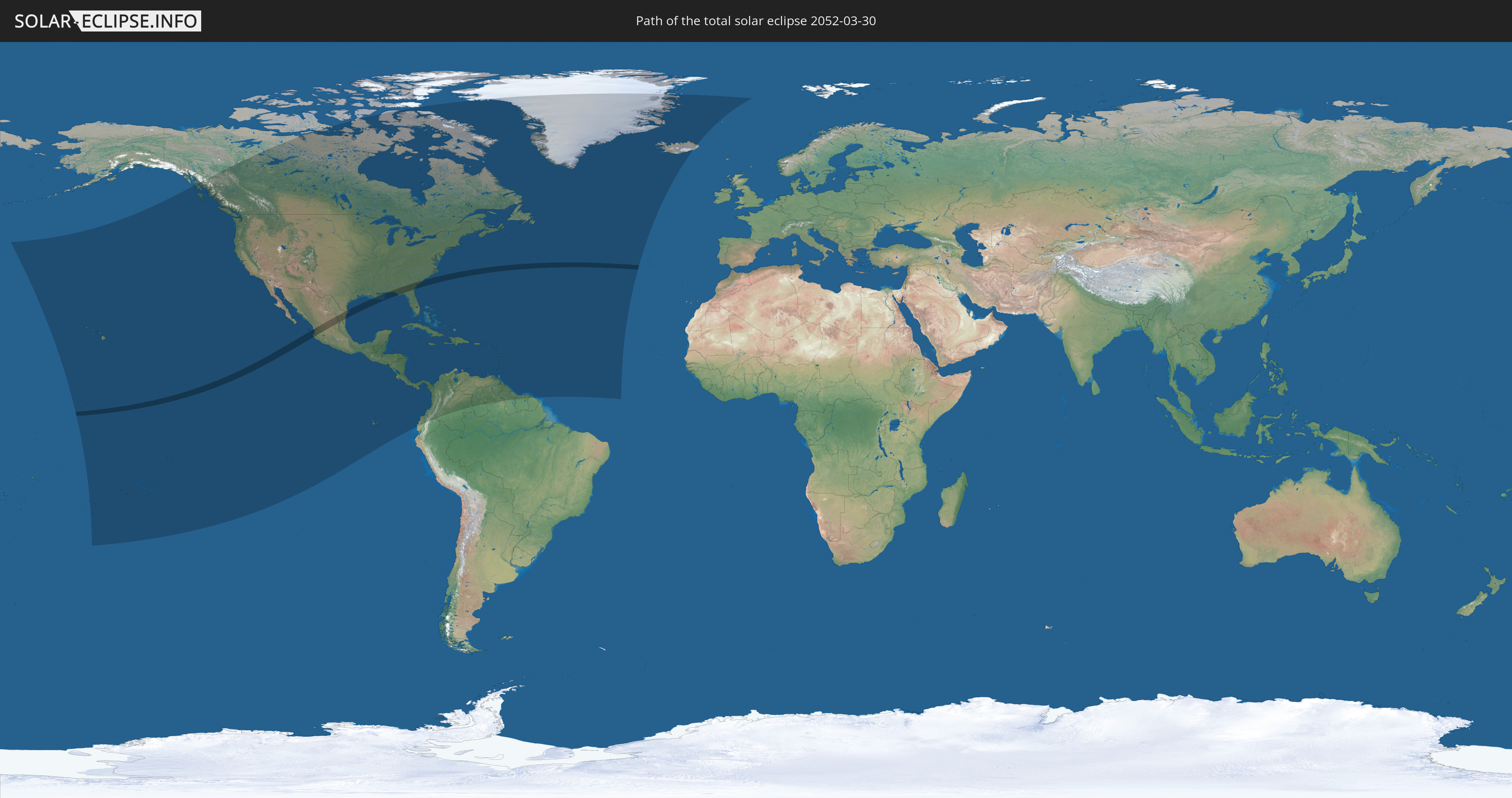
Die Sonnenfinsternis am 30.03.2052 kann man in 52 Ländern als partielle Sonnenfinsternis beobachten.
Der Finsternispfad verläuft durch 3 Länder. Nur in diesen Ländern ist sie als totale Sonnenfinsternis zu sehen.
In den folgenden Ländern ist die Sonnenfinsternis total zu sehen
 Vereinigte Staaten
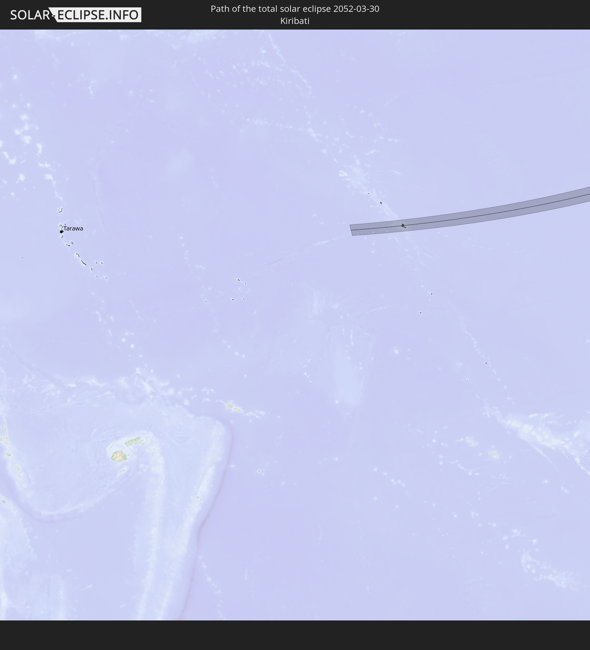 Kiribati
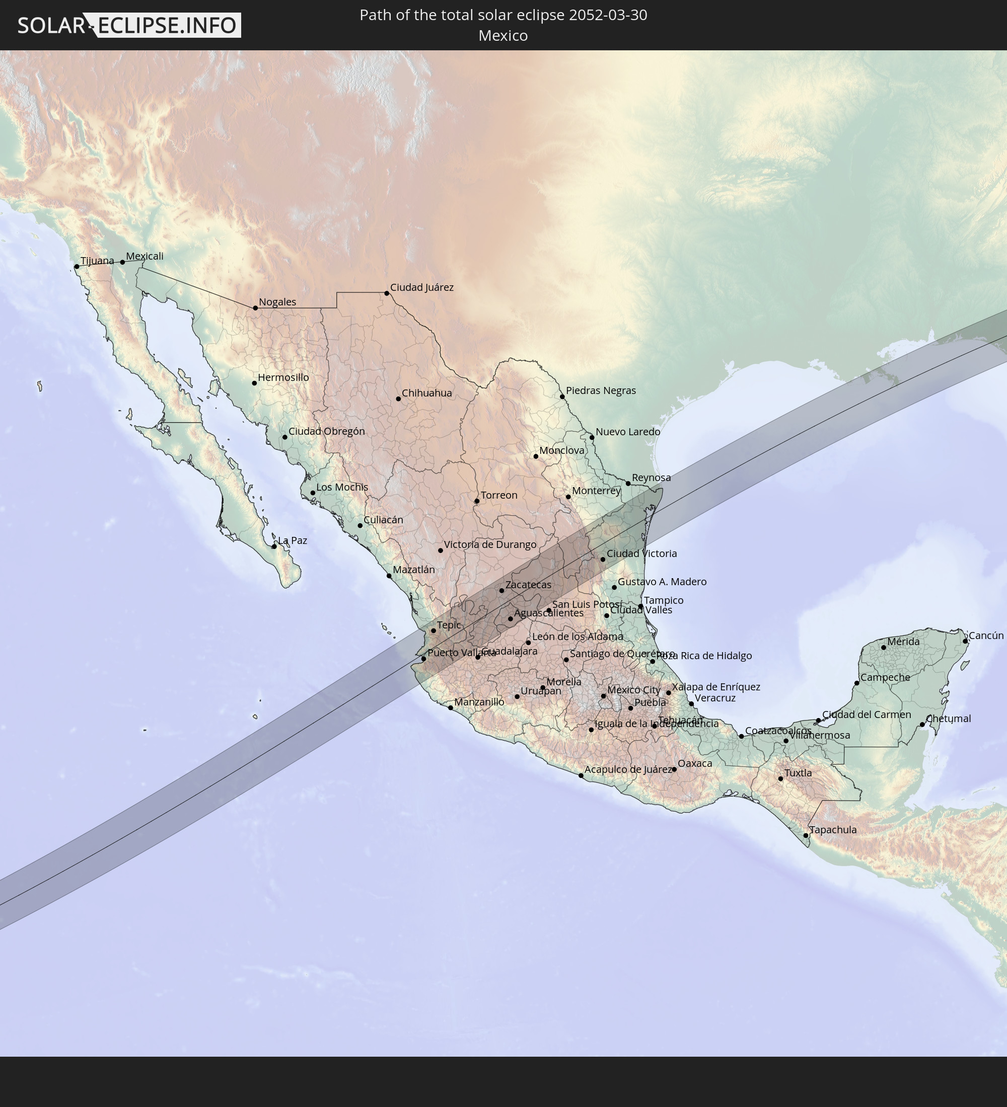 Mexiko
In den folgenden Ländern ist die Sonnenfinsternis partiell zu sehen
 Vereinigte Staaten
 United States Minor Outlying Islands
 Kiribati
 Cookinseln
 Französisch-Polynesien
 Kanada
 Pitcairninseln
 Mexiko
 Grönland
 Guatemala
 Ecuador
 El Salvador
 Honduras
 Belize
 Nicaragua
 Costa Rica
 Kuba
Kuba
 Panama
 Kolumbien
 Kaimaninseln
 Bahamas
 Jamaika
 Haiti
Haiti
 Brasilien
 Venezuela
 Turks- und Caicosinseln
 Dominikanische Republik
 Aruba
Aruba
 Puerto Rico
 Amerikanische Jungferninseln
 Bermuda
 Britische Jungferninseln
 Anguilla
 Saint-Martin
 Saint-Barthélemy
 St. Kitts und Nevis
 Antigua und Barbuda
 Montserrat
 Trinidad und Tobago
 Guadeloupe
 Grenada
 Dominica
 St. Vincent und die Grenadinen
 Guyana
 Martinique
 St. Lucia
 Barbados
 Suriname
 Saint-Pierre und Miquelon
 Französisch-Guayana
 Portugal
 Island
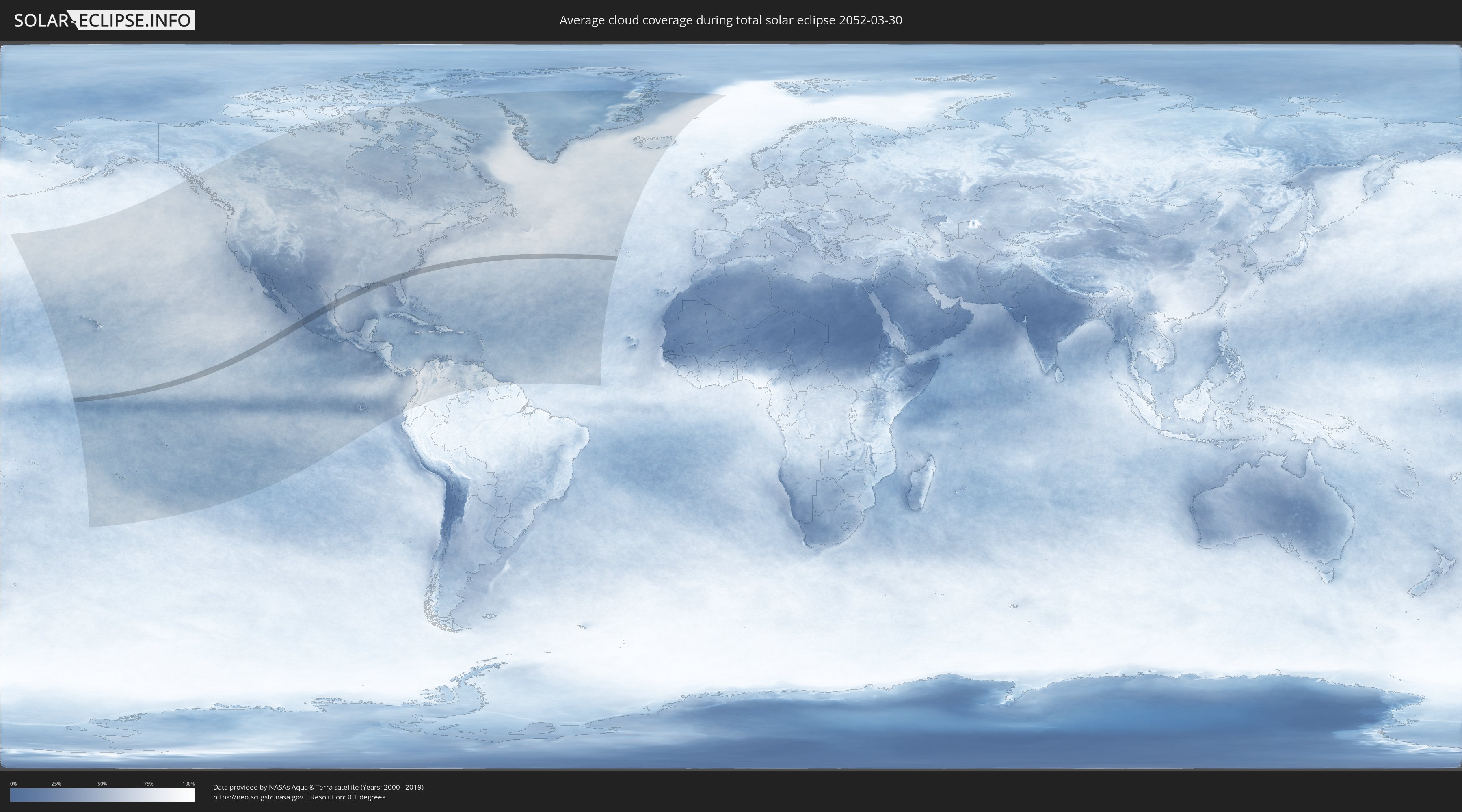
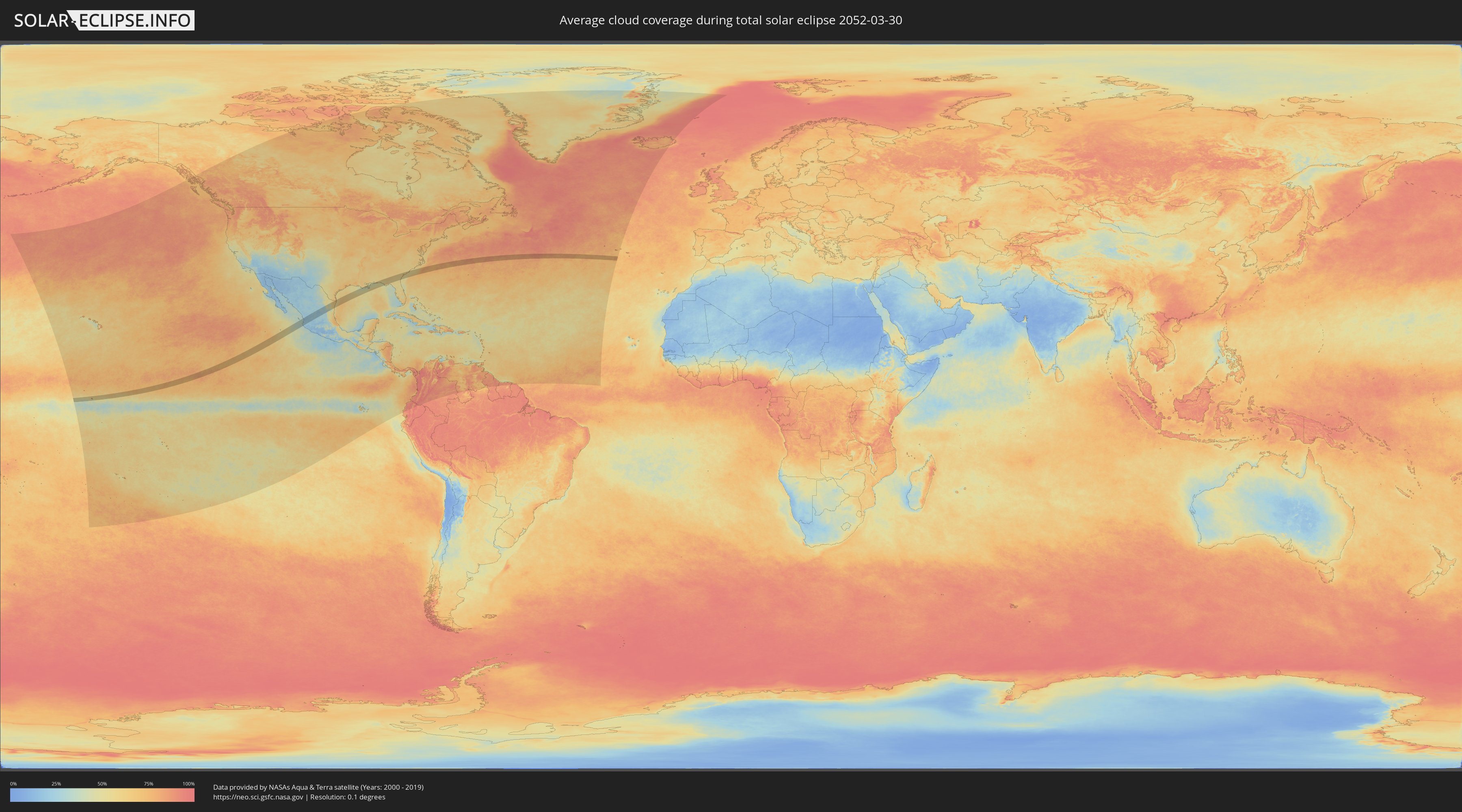
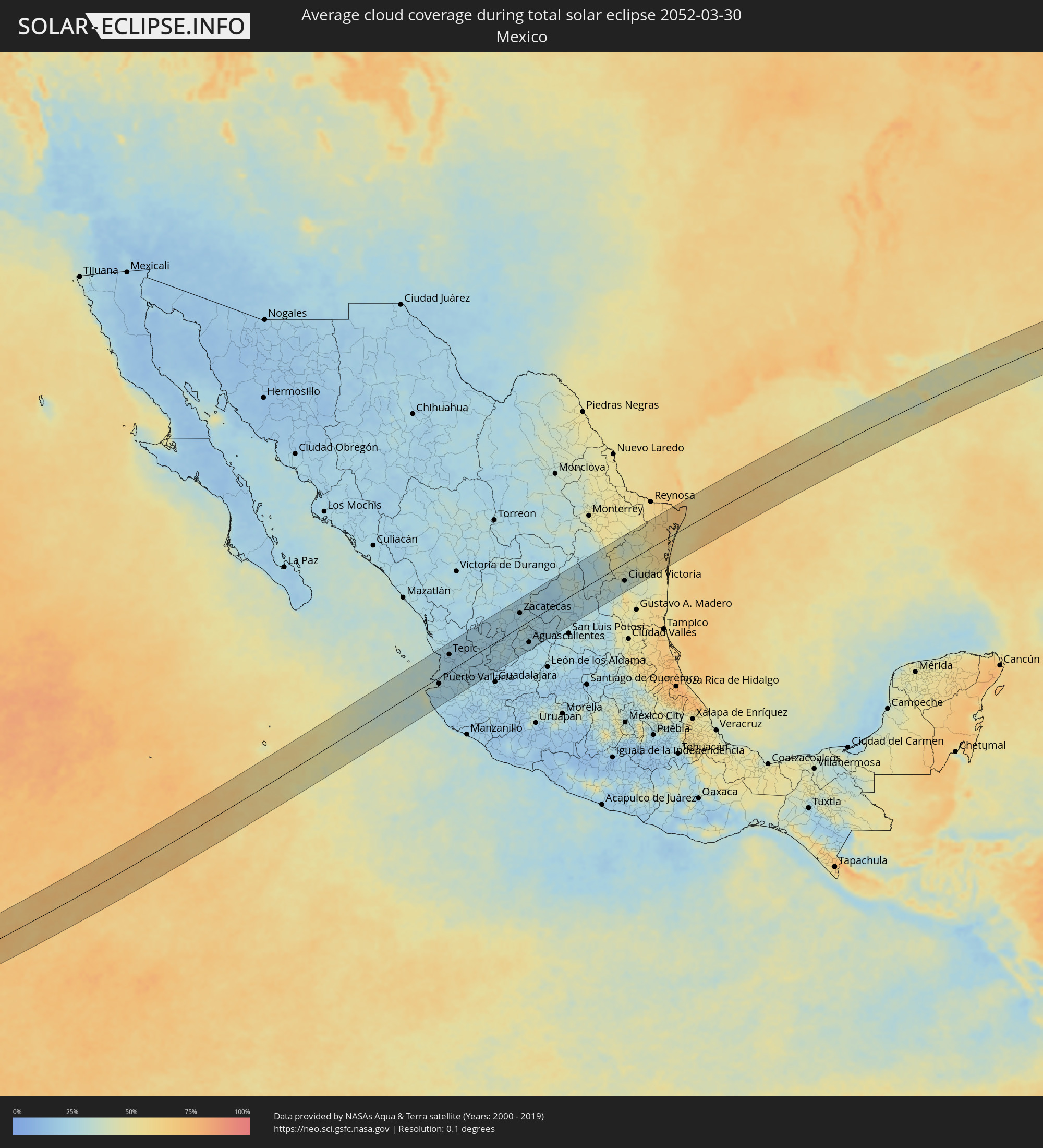
Wie wird das Wetter während der totalen Sonnenfinsternis am 30.03.2052?
Wo ist der beste Ort, um die totale Sonnenfinsternis vom 30.03.2052 zu beobachten?
Die folgenden Karten zeigen die durchschnittliche Bewölkung für den Tag, an dem die totale Sonnenfinsternis
stattfindet. Mit Hilfe der Karten lässt sich der Ort entlang des Finsternispfades eingrenzen,
der die besten Aussichen auf einen klaren wolkenfreien Himmel bietet.
Trotzdem muss man immer lokale Gegenenheiten beachten und sollte sich genau über das Wetter an seinem
gewählten Beobachtungsort informieren.
Die Daten stammen von den beiden NASA-Satelliten
AQUA und TERRA
und wurden über einen Zeitraum von 19 Jahren (2000 - 2019) gemittelt.
Detaillierte Länderkarten
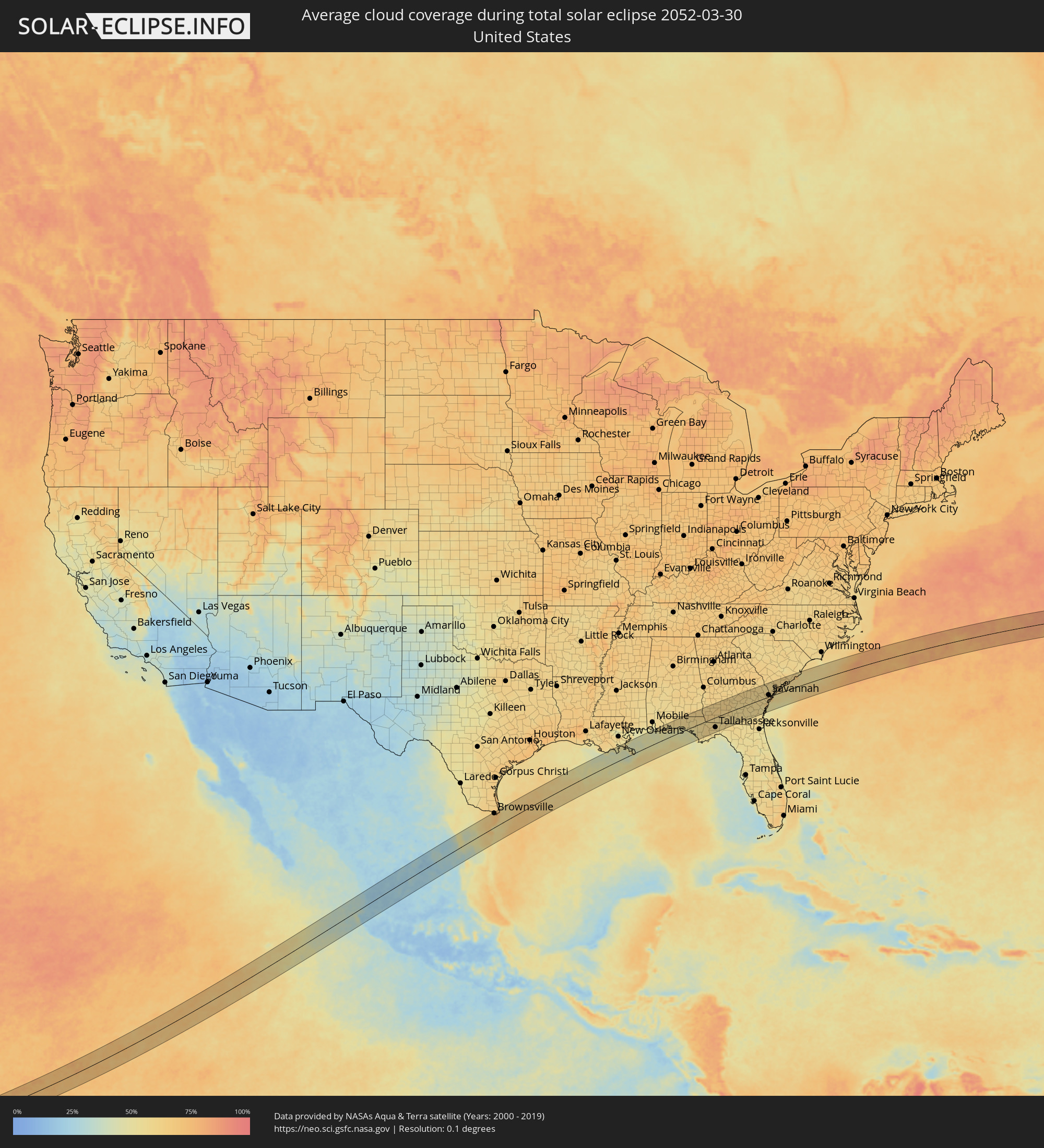 Vereinigte Staaten
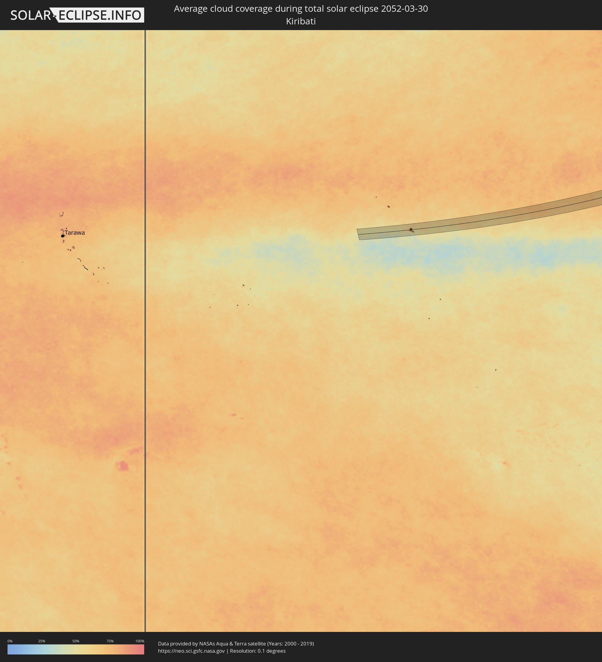 Kiribati
 Mexiko
Orte im Finsternispfad
Die nachfolgene Tabelle zeigt Städte und Orte mit mehr als 5.000 Einwohnern, die sich im Finsternispfad befinden. Städte mit mehr als 100.000 Einwohnern sind dick gekennzeichnet. Mit einem Klick auf den Ort öffnet sich eine Detailkarte die die Lage des jeweiligen Ortes zusammen mit dem Verlauf der zentralen Finsternis präsentiert.
| Ort | Typ | Dauer der Verfinsterung | Ortszeit bei maximaler Verfinsterung | Entfernung zur Zentrallinie | Ø Bewölkung |
|
Bucerías, Nayarit
|
total | - | 12:21:10 UTC-06:00 | 0 km | 26% |
|
San Blas, Nayarit
|
total | - | 11:22:31 UTC-07:00 | 72 km | 30% |
|
Las Jarretaderas, Nayarit
|
total | - | 12:21:13 UTC-06:00 | 9 km | 30% |
|
Tomatlán, Jalisco
|
total | - | 12:20:05 UTC-06:00 | 82 km | 24% |
|
Valle de Banderas, Nayarit
|
total | - | 12:21:27 UTC-06:00 | 1 km | 27% |
|
Puerto Vallarta, Jalisco
|
total | - | 12:21:12 UTC-06:00 | 19 km | 25% |
|
Ixtapa, Jalisco
|
total | - | 12:21:25 UTC-06:00 | 11 km | 26% |
|
San Juan de Abajo, Nayarit
|
total | - | 12:21:36 UTC-06:00 | 2 km | 27% |
|
Zacualpan, Nayarit
|
total | - | 11:22:20 UTC-07:00 | 37 km | 27% |
|
Las Varas, Nayarit
|
total | - | 11:22:18 UTC-07:00 | 29 km | 25% |
|
Compostela, Nayarit
|
total | - | 11:22:56 UTC-07:00 | 22 km | 23% |
|
Tepic, Nayarit
|
total | - | 11:23:22 UTC-07:00 | 47 km | 20% |
|
Puga, Nayarit
|
total | - | 11:23:39 UTC-07:00 | 50 km | 21% |
|
Talpa de Allende, Jalisco
|
total | - | 12:21:47 UTC-06:00 | 63 km | 23% |
|
Mascota, Jalisco
|
total | - | 12:22:05 UTC-06:00 | 52 km | 23% |
|
Ahuacatlán, Nayarit
|
total | - | 11:23:38 UTC-07:00 | 19 km | 24% |
|
Jala, Nayarit
|
total | - | 11:23:49 UTC-07:00 | 16 km | 24% |
|
Ixtlán del Río, Nayarit
|
total | - | 11:23:52 UTC-07:00 | 26 km | 25% |
|
Etzatlán, Jalisco
|
total | - | 12:24:09 UTC-06:00 | 68 km | 25% |
|
Antonio Escobedo, Jalisco
|
total | - | 12:24:20 UTC-06:00 | 68 km | 24% |
|
Ahualulco de Mercado, Jalisco
|
total | - | 12:24:17 UTC-06:00 | 80 km | 23% |
|
Tequila, Jalisco
|
total | - | 12:24:54 UTC-06:00 | 70 km | 25% |
|
Amatitán, Jalisco
|
total | - | 12:25:04 UTC-06:00 | 81 km | 23% |
|
Tlaltenango de Sánchez Román, Zacatecas
|
total | - | 12:27:32 UTC-06:00 | 15 km | 26% |
|
Colotlán, Jalisco
|
total | - | 12:28:07 UTC-06:00 | 15 km | 22% |
|
Juchipila, Zacatecas
|
total | - | 12:27:24 UTC-06:00 | 60 km | 22% |
|
Jerez de García Salinas, Zacatecas
|
total | - | 12:29:34 UTC-06:00 | 50 km | 24% |
|
Jalpa, Zacatecas
|
total | - | 12:28:04 UTC-06:00 | 46 km | 22% |
|
Tabasco, Zacatecas
|
total | - | 12:28:35 UTC-06:00 | 28 km | 22% |
|
Villanueva, Zacatecas
|
total | - | 12:29:23 UTC-06:00 | 17 km | 22% |
|
Nochistlán de Mejía, Zacatecas
|
total | - | 12:27:59 UTC-06:00 | 79 km | 23% |
|
Calvillo, Aguascalientes
|
total | - | 12:29:00 UTC-06:00 | 40 km | 28% |
|
Víctor Rosales, Zacatecas
|
total | - | 12:30:41 UTC-06:00 | 63 km | 24% |
|
Morelos, Zacatecas
|
total | - | 12:30:46 UTC-06:00 | 50 km | 26% |
|
Villa Hidalgo, Jalisco
|
total | - | 12:29:04 UTC-06:00 | 63 km | 25% |
|
Zacatecas, Zacatecas
|
total | - | 12:30:42 UTC-06:00 | 40 km | 25% |
|
Guadalupe, Zacatecas
|
total | - | 12:30:49 UTC-06:00 | 34 km | 25% |
|
Tacoaleche, Zacatecas
|
total | - | 12:31:12 UTC-06:00 | 35 km | 25% |
|
Trancoso, Zacatecas
|
total | - | 12:31:10 UTC-06:00 | 25 km | 24% |
|
San Pedro Piedra Gorda, Zacatecas
|
total | - | 12:30:47 UTC-06:00 | 3 km | 26% |
|
Jesús María, Aguascalientes
|
total | - | 12:30:04 UTC-06:00 | 50 km | 23% |
|
Pocitos, Aguascalientes
|
total | - | 12:30:02 UTC-06:00 | 54 km | 23% |
|
Rincón de Romos, Aguascalientes
|
total | - | 12:30:31 UTC-06:00 | 26 km | 24% |
|
Jesús Gómez Portugal (Margaritas), Aguascalientes
|
total | - | 12:30:15 UTC-06:00 | 49 km | 23% |
|
Jesús Gómez Portugal, Aguascalientes
|
total | - | 12:30:15 UTC-06:00 | 49 km | 23% |
|
Aguascalientes, Aguascalientes
|
total | - | 12:30:06 UTC-06:00 | 61 km | 23% |
|
Luis Moya, Zacatecas
|
total | - | 12:31:00 UTC-06:00 | 10 km | 24% |
|
Dulce Grande, San Luis Potosí
|
total | - | 12:32:00 UTC-06:00 | 40 km | 23% |
|
Los Zacatones, San Luis Potosí
|
total | - | 12:32:14 UTC-06:00 | 30 km | 24% |
|
Loreto, Zacatecas
|
total | - | 12:31:22 UTC-06:00 | 39 km | 22% |
|
Villa García, Zacatecas
|
total | - | 12:31:17 UTC-06:00 | 52 km | 22% |
|
Villa González Ortega, Zacatecas
|
total | - | 12:31:54 UTC-06:00 | 21 km | 24% |
|
Salinas de Hidalgo, San Luis Potosí
|
total | - | 12:32:33 UTC-06:00 | 20 km | 23% |
|
Charcas, San Luis Potosí
|
total | - | 12:34:41 UTC-06:00 | 5 km | 25% |
|
Matehuala, San Luis Potosí
|
total | - | 12:36:33 UTC-06:00 | 19 km | 28% |
|
Doctor Arroyo, Nuevo León
|
total | - | 12:37:40 UTC-06:00 | 3 km | 27% |
|
Linares, Nuevo León
|
total | - | 12:40:44 UTC-06:00 | 78 km | 48% |
|
La Reforma, Nuevo León
|
total | - | 12:40:34 UTC-06:00 | 62 km | 50% |
|
Estación Santa Engracia, Tamaulipas
|
total | - | 12:40:27 UTC-06:00 | 21 km | 40% |
|
Guillermo Zúñiga, Tamaulipas
|
total | - | 12:40:27 UTC-06:00 | 21 km | 40% |
|
Ciudad Victoria, Tamaulipas
|
total | - | 12:40:13 UTC-06:00 | 50 km | 34% |
|
Nuevo Padilla, Tamaulipas
|
total | - | 12:41:13 UTC-06:00 | 34 km | 39% |
|
Santander Jiménez, Tamaulipas
|
total | - | 12:42:25 UTC-06:00 | 39 km | 47% |
|
Abasolo, Tamaulipas
|
total | - | 12:42:28 UTC-06:00 | 60 km | 46% |
|
San Fernando, Tamaulipas
|
total | - | 12:44:02 UTC-06:00 | 4 km | 58% |
|
Valle Hermoso, Tamaulipas
|
total | - | 12:45:52 UTC-06:00 | 67 km | 62% |
|
Heroica Matamoros, Tamaulipas
|
total | - | 12:46:51 UTC-06:00 | 71 km | 70% |
|
Brownsville, Texas
|
total | - | 12:46:53 UTC-06:00 | 73 km | 70% |
|
Cameron Park Colonia, Texas
|
total | - | 12:47:01 UTC-06:00 | 79 km | 68% |
|
Cameron Park, Texas
|
total | - | 12:47:01 UTC-06:00 | 78 km | 68% |
|
Port Isabel, Texas
|
total | - | 12:47:46 UTC-06:00 | 75 km | 67% |
|
Gulf Shores, Alabama
|
total | - | 13:12:48 UTC-06:00 | 59 km | 46% |
|
Foley, Alabama
|
total | - | 13:12:57 UTC-06:00 | 74 km | 53% |
|
Orange Beach, Alabama
|
total | - | 13:13:06 UTC-06:00 | 58 km | 51% |
|
Bellview, Florida
|
total | - | 13:13:44 UTC-06:00 | 65 km | 53% |
|
Myrtle Grove, Florida
|
total | - | 13:13:44 UTC-06:00 | 61 km | 56% |
|
Gonzalez, Florida
|
total | - | 13:13:52 UTC-06:00 | 76 km | 56% |
|
West Pensacola, Florida
|
total | - | 13:13:47 UTC-06:00 | 60 km | 56% |
|
Warrington, Florida
|
total | - | 13:13:46 UTC-06:00 | 56 km | 56% |
|
Ensley, Florida
|
total | - | 13:13:52 UTC-06:00 | 69 km | 53% |
|
Brent, Florida
|
total | - | 13:13:54 UTC-06:00 | 63 km | 53% |
|
Pensacola, Florida
|
total | - | 13:13:55 UTC-06:00 | 57 km | 57% |
|
Ferry Pass, Florida
|
total | - | 13:13:59 UTC-06:00 | 66 km | 53% |
|
East Pensacola Heights, Florida
|
total | - | 13:14:00 UTC-06:00 | 57 km | 57% |
|
Gulf Breeze, Florida
|
total | - | 13:13:59 UTC-06:00 | 49 km | 57% |
|
Pace, Florida
|
total | - | 13:14:09 UTC-06:00 | 73 km | 54% |
|
Milton, Florida
|
total | - | 13:14:25 UTC-06:00 | 72 km | 51% |
|
East Milton, Florida
|
total | - | 13:14:26 UTC-06:00 | 69 km | 51% |
|
Navarre, Florida
|
total | - | 13:14:37 UTC-06:00 | 41 km | 56% |
|
Wright, Florida
|
total | - | 13:15:07 UTC-06:00 | 38 km | 54% |
|
Fort Walton Beach, Florida
|
total | - | 13:15:08 UTC-06:00 | 34 km | 52% |
|
Ocean City, Florida
|
total | - | 13:15:09 UTC-06:00 | 36 km | 52% |
|
Crestview, Florida
|
total | - | 13:15:27 UTC-06:00 | 67 km | 59% |
|
Lake Lorraine, Florida
|
total | - | 13:15:15 UTC-06:00 | 34 km | 52% |
|
Eglin Village, Florida
|
total | - | 13:15:19 UTC-06:00 | 35 km | 53% |
|
Valparaiso, Florida
|
total | - | 13:15:26 UTC-06:00 | 38 km | 53% |
|
Destin, Florida
|
total | - | 13:15:22 UTC-06:00 | 26 km | 50% |
|
Niceville, Florida
|
total | - | 13:15:28 UTC-06:00 | 38 km | 53% |
|
Miramar Beach, Florida
|
total | - | 13:15:38 UTC-06:00 | 19 km | 47% |
|
DeFuniak Springs, Florida
|
total | - | 13:16:20 UTC-06:00 | 45 km | 60% |
|
Panama City Beach, Florida
|
total | - | 13:16:38 UTC-06:00 | 22 km | 48% |
|
Upper Grand Lagoon, Florida
|
total | - | 13:16:45 UTC-06:00 | 26 km | 48% |
|
Panama City, Florida
|
total | - | 13:16:55 UTC-06:00 | 30 km | 48% |
|
Lynn Haven, Florida
|
total | - | 13:17:00 UTC-06:00 | 21 km | 46% |
|
Springfield, Florida
|
total | - | 13:17:01 UTC-06:00 | 32 km | 46% |
|
Callaway, Florida
|
total | - | 13:17:06 UTC-06:00 | 34 km | 46% |
|
Dothan, Alabama
|
total | - | 13:18:05 UTC-06:00 | 69 km | 60% |
|
Marianna, Florida
|
total | - | 13:18:09 UTC-06:00 | 17 km | 57% |
|
Blakely, Georgia
|
total | - | 14:19:04 UTC-05:00 | 68 km | 60% |
|
Quincy, Florida
|
total | - | 14:19:20 UTC-05:00 | 26 km | 60% |
|
Bainbridge, Georgia
|
total | - | 14:19:31 UTC-05:00 | 7 km | 59% |
|
Tallahassee, Florida
|
total | - | 14:19:51 UTC-05:00 | 52 km | 57% |
|
Camilla, Georgia
|
total | - | 14:20:24 UTC-05:00 | 27 km | 62% |
|
Cairo, Georgia
|
total | - | 14:20:14 UTC-05:00 | 10 km | 58% |
|
Albany, Georgia
|
total | - | 14:20:41 UTC-05:00 | 61 km | 61% |
|
Thomasville, Georgia
|
total | - | 14:20:39 UTC-05:00 | 22 km | 57% |
|
Sylvester, Georgia
|
total | - | 14:21:16 UTC-05:00 | 45 km | 63% |
|
Moultrie, Georgia
|
total | - | 14:21:12 UTC-05:00 | 7 km | 60% |
|
Tifton, Georgia
|
total | - | 14:21:52 UTC-05:00 | 25 km | 61% |
|
Adel, Georgia
|
total | - | 14:21:53 UTC-05:00 | 11 km | 56% |
|
Valdosta, Georgia
|
total | - | 14:22:01 UTC-05:00 | 47 km | 53% |
|
Fitzgerald, Georgia
|
total | - | 14:22:28 UTC-05:00 | 43 km | 61% |
|
McRae, Georgia
|
total | - | 14:23:18 UTC-05:00 | 68 km | 61% |
|
Douglas, Georgia
|
total | - | 14:23:09 UTC-05:00 | 8 km | 55% |
|
Vidalia, Georgia
|
total | - | 14:24:16 UTC-05:00 | 67 km | 60% |
|
Waycross, Georgia
|
total | - | 14:23:58 UTC-05:00 | 40 km | 57% |
|
Jesup, Georgia
|
total | - | 14:25:00 UTC-05:00 | 15 km | 57% |
|
Statesboro, Georgia
|
total | - | 14:25:31 UTC-05:00 | 70 km | 60% |
|
Hinesville, Georgia
|
total | - | 14:25:38 UTC-05:00 | 1 km | 58% |
|
Dock Junction, Georgia
|
total | - | 14:25:32 UTC-05:00 | 69 km | 56% |
|
Brunswick, Georgia
|
total | - | 14:25:34 UTC-05:00 | 75 km | 60% |
|
Country Club Estates, Georgia
|
total | - | 14:25:38 UTC-05:00 | 70 km | 56% |
|
Richmond Hill, Georgia
|
total | - | 14:26:13 UTC-05:00 | 1 km | 57% |
|
Pooler, Georgia
|
total | - | 14:26:23 UTC-05:00 | 17 km | 61% |
|
Rincon, Georgia
|
total | - | 14:26:28 UTC-05:00 | 36 km | 60% |
|
Georgetown, Georgia
|
total | - | 14:26:22 UTC-05:00 | 3 km | 61% |
|
Port Wentworth, Georgia
|
total | - | 14:26:33 UTC-05:00 | 18 km | 61% |
|
Garden City, Georgia
|
total | - | 14:26:33 UTC-05:00 | 14 km | 61% |
|
Savannah, Georgia
|
total | - | 14:26:38 UTC-05:00 | 9 km | 60% |
|
Skidaway Island, Georgia
|
total | - | 14:26:41 UTC-05:00 | 8 km | 59% |
|
Whitemarsh Island, Georgia
|
total | - | 14:26:46 UTC-05:00 | 1 km | 68% |
|
Wilmington Island, Georgia
|
total | - | 14:26:51 UTC-05:00 | 3 km | 68% |
|
Bluffton, South Carolina
|
total | - | 14:27:08 UTC-05:00 | 18 km | 61% |
|
Laurel Bay, South Carolina
|
total | - | 14:27:20 UTC-05:00 | 37 km | 59% |
|
Hilton Head Island, South Carolina
|
total | - | 14:27:19 UTC-05:00 | 12 km | 58% |
|
Burton, South Carolina
|
total | - | 14:27:26 UTC-05:00 | 34 km | 59% |
|
Port Royal, South Carolina
|
total | - | 14:27:29 UTC-05:00 | 27 km | 59% |
|
Beaufort, South Carolina
|
total | - | 14:27:32 UTC-05:00 | 32 km | 59% |
|
Centerville, South Carolina
|
total | - | 14:28:36 UTC-05:00 | 75 km | 61% |
|
Ladson, South Carolina
|
total | - | 14:28:42 UTC-05:00 | 72 km | 63% |
|
Goose Creek, South Carolina
|
total | - | 14:28:50 UTC-05:00 | 69 km | 61% |
|
Hanahan, South Carolina
|
total | - | 14:28:50 UTC-05:00 | 62 km | 61% |
|
North Charleston, South Carolina
|
total | - | 14:28:54 UTC-05:00 | 54 km | 61% |
|
Charleston, South Carolina
|
total | - | 14:28:57 UTC-05:00 | 45 km | 61% |
|
Mount Pleasant, South Carolina
|
total | - | 14:29:05 UTC-05:00 | 44 km | 61% |