Totale Sonnenfinsternis vom 03.05.2106
| Wochentag: | Montag |
| Maximale Dauer der Verfinsterung: | 03m47s |
| Maximale Breite des Finsternispfades: | 177 km |
| Saroszyklus: | 130 |
| Bedeckungsgrad: | 100% |
| Magnitude: | 1.0472 |
| Gamma: | 0.4681 |
Wo kann man die Sonnenfinsternis vom 03.05.2106 sehen?
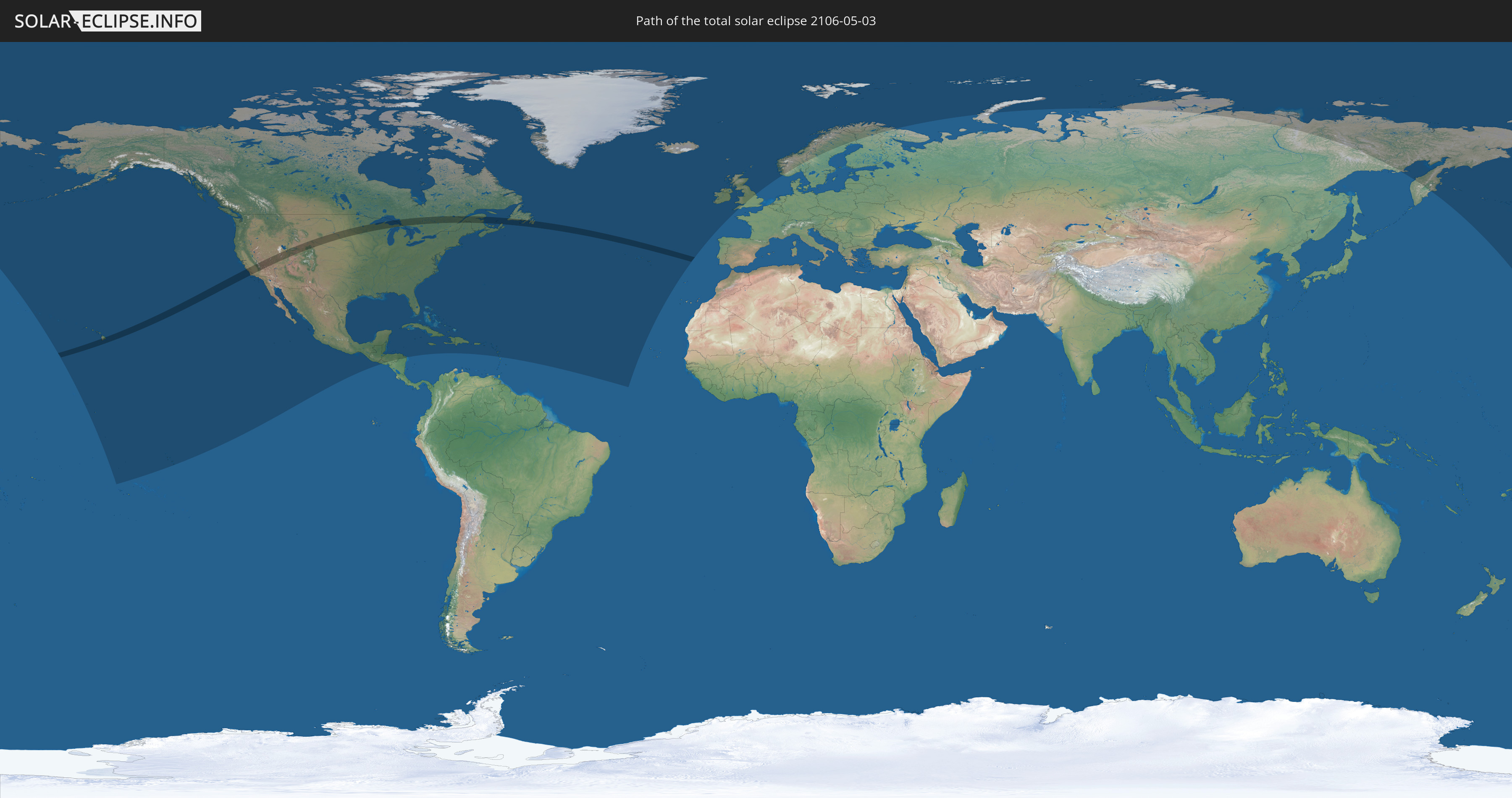
Die Sonnenfinsternis am 03.05.2106 kann man in 43 Ländern als partielle Sonnenfinsternis beobachten.
Der Finsternispfad verläuft durch 3 Länder. Nur in diesen Ländern ist sie als totale Sonnenfinsternis zu sehen.
In den folgenden Ländern ist die Sonnenfinsternis total zu sehen
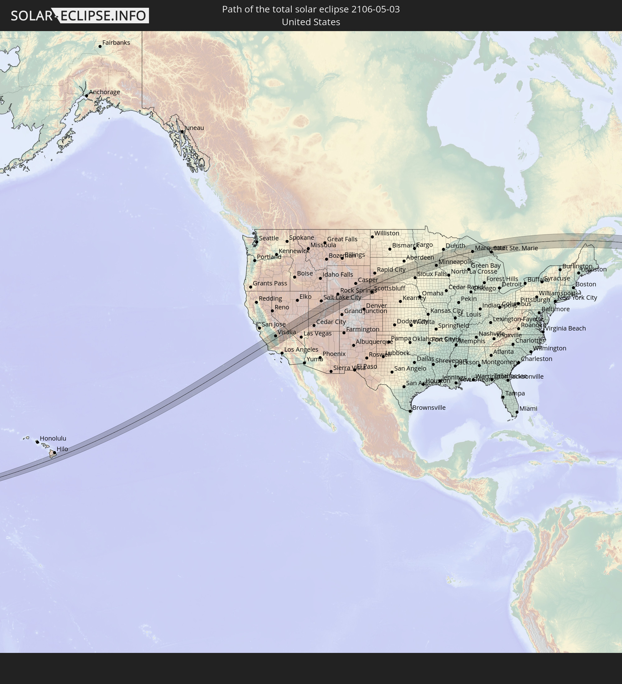 Vereinigte Staaten
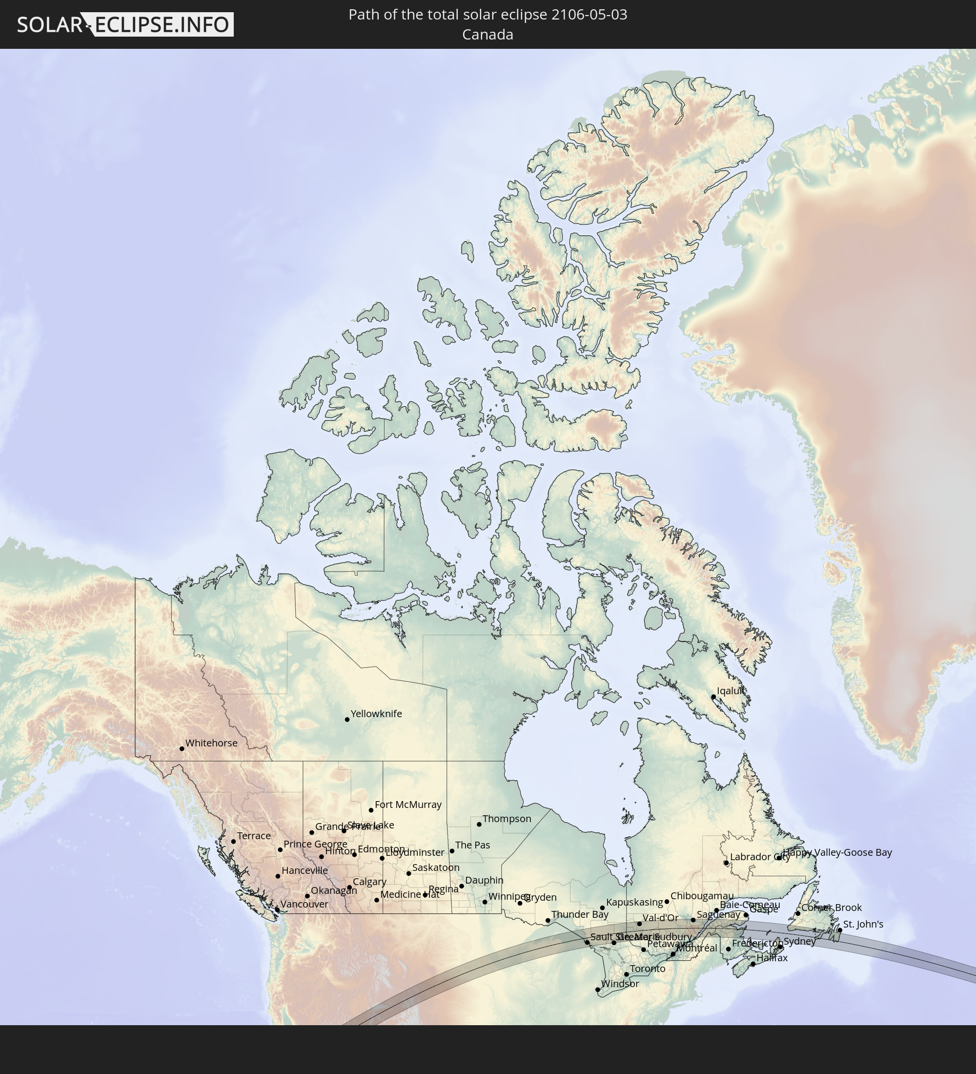 Kanada
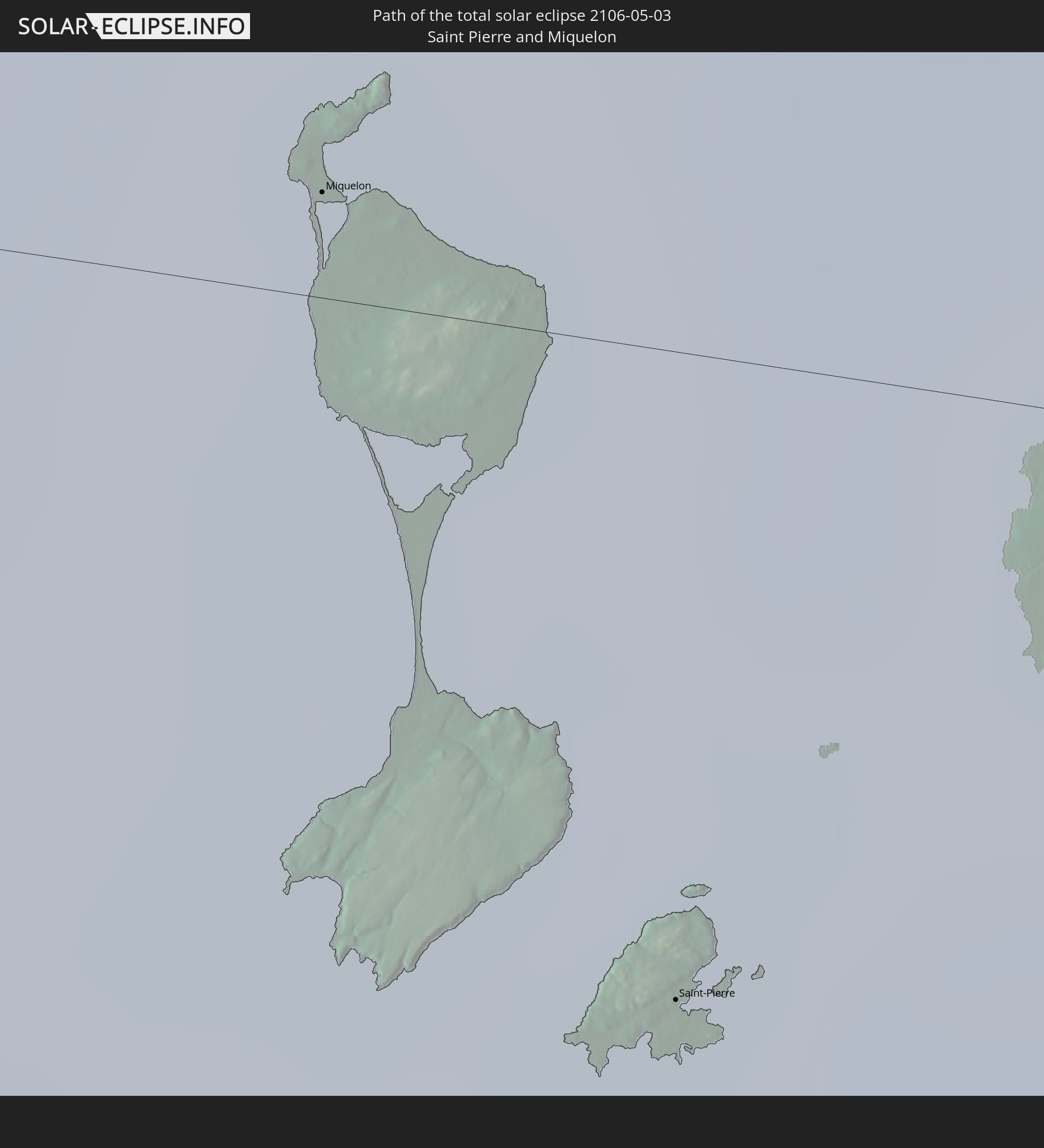 Saint-Pierre und Miquelon
In den folgenden Ländern ist die Sonnenfinsternis partiell zu sehen
 Russland
 Vereinigte Staaten
 United States Minor Outlying Islands
 Kiribati
 Französisch-Polynesien
 Kanada
 Mexiko
 Grönland
 Guatemala
 El Salvador
 Honduras
 Belize
 Nicaragua
 Kuba
Kuba
 Kaimaninseln
 Bahamas
 Jamaika
 Haiti
Haiti
 Turks- und Caicosinseln
 Dominikanische Republik
 Puerto Rico
 Amerikanische Jungferninseln
 Bermuda
 Britische Jungferninseln
 Anguilla
 Saint-Martin
 Saint-Barthélemy
 St. Kitts und Nevis
 Antigua und Barbuda
 Montserrat
 Guadeloupe
 Dominica
 Saint-Pierre und Miquelon
 Portugal
 Island
 Irland
 Spitzbergen
 Vereinigtes Königreich
 Färöer
 Isle of Man
 Norwegen
 Schweden
 Finnland
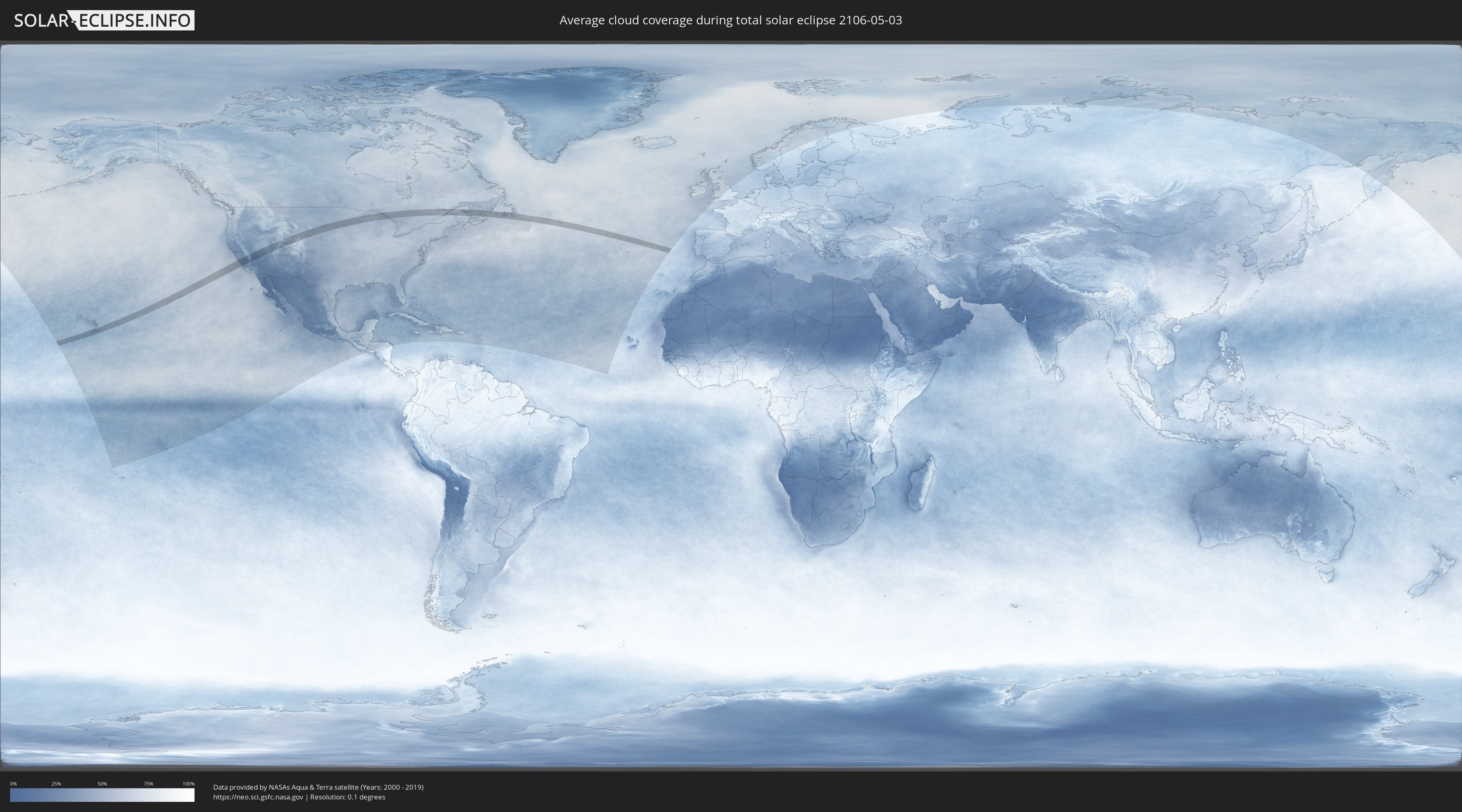
Wie wird das Wetter während der totalen Sonnenfinsternis am 03.05.2106?
Wo ist der beste Ort, um die totale Sonnenfinsternis vom 03.05.2106 zu beobachten?
Die folgenden Karten zeigen die durchschnittliche Bewölkung für den Tag, an dem die totale Sonnenfinsternis
stattfindet. Mit Hilfe der Karten lässt sich der Ort entlang des Finsternispfades eingrenzen,
der die besten Aussichen auf einen klaren wolkenfreien Himmel bietet.
Trotzdem muss man immer lokale Gegenenheiten beachten und sollte sich genau über das Wetter an seinem
gewählten Beobachtungsort informieren.
Die Daten stammen von den beiden NASA-Satelliten
AQUA und TERRA
und wurden über einen Zeitraum von 19 Jahren (2000 - 2019) gemittelt.

Detaillierte Länderkarten
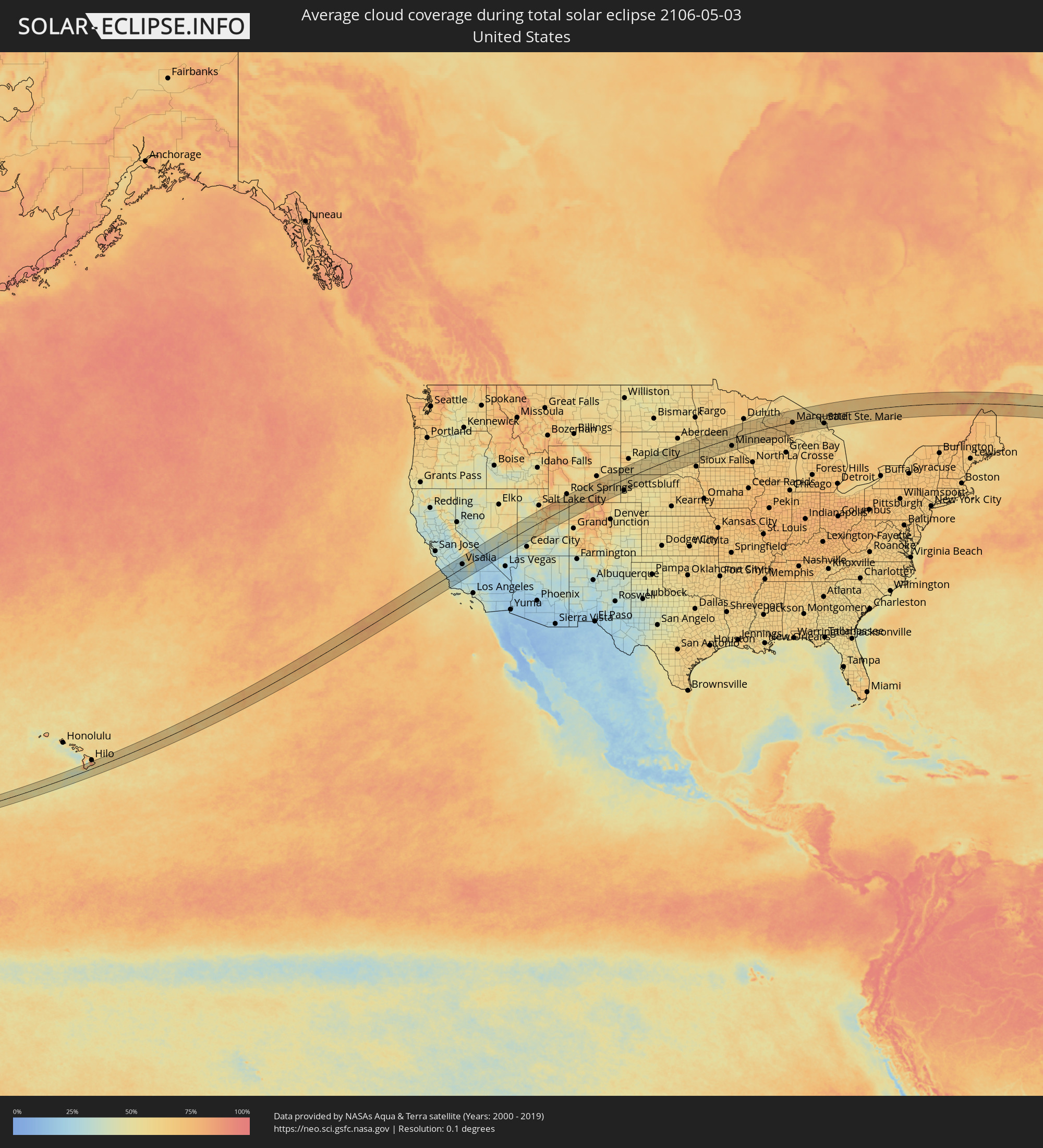 Vereinigte Staaten
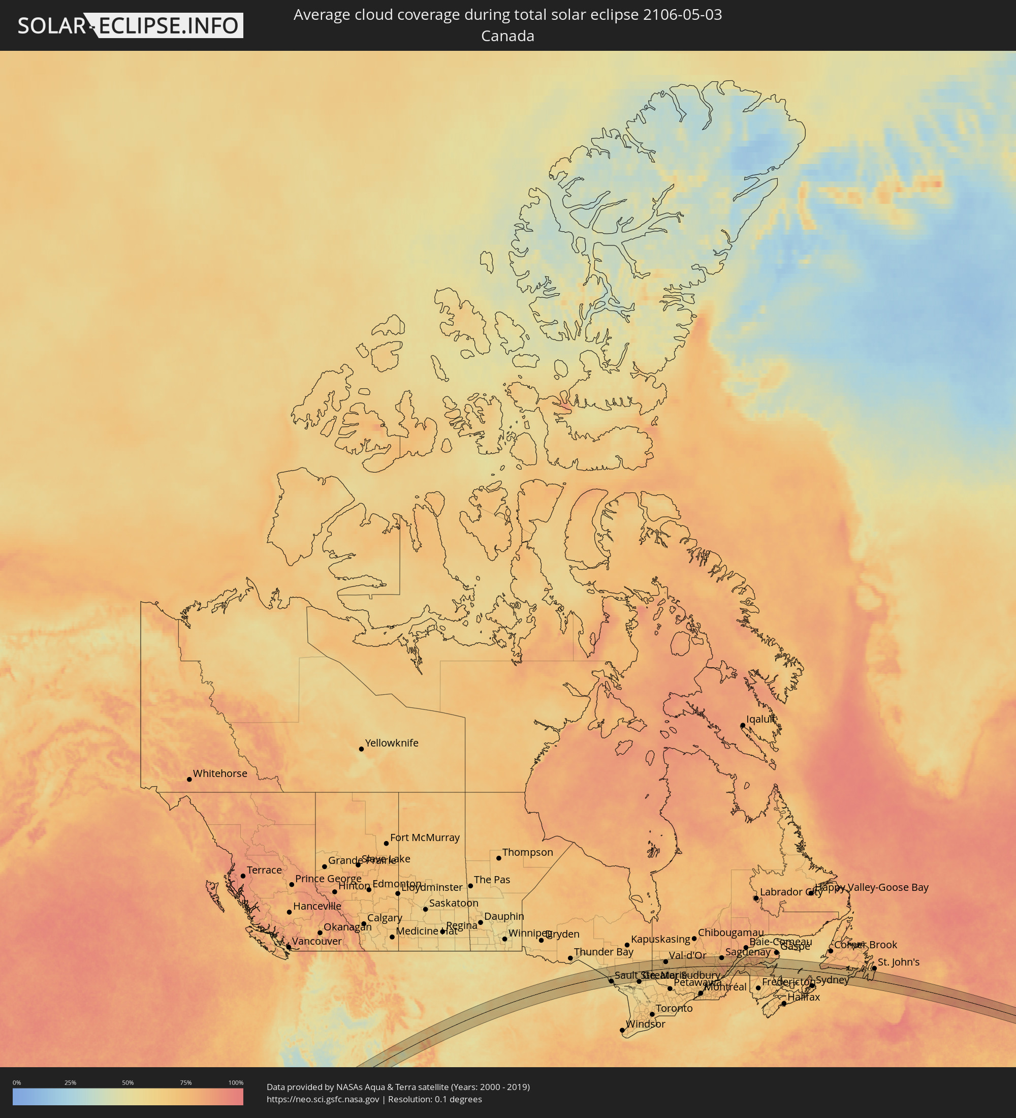 Kanada
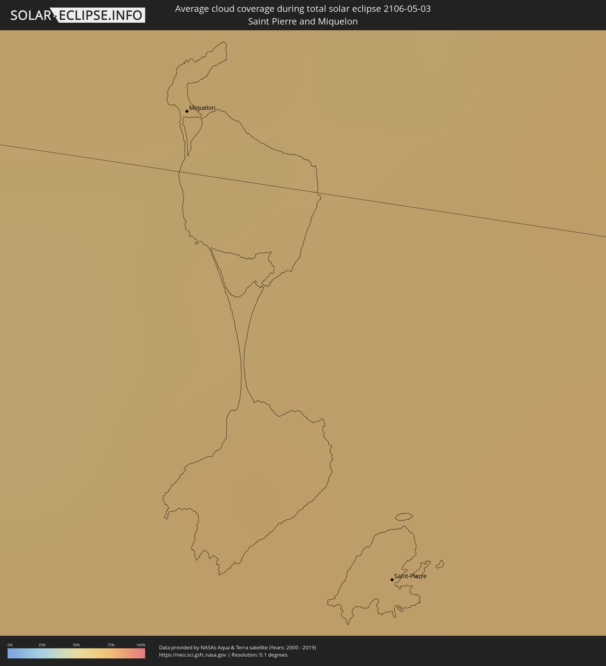 Saint-Pierre und Miquelon
Orte im Finsternispfad
Die nachfolgene Tabelle zeigt Städte und Orte mit mehr als 5.000 Einwohnern, die sich im Finsternispfad befinden. Städte mit mehr als 100.000 Einwohnern sind dick gekennzeichnet. Mit einem Klick auf den Ort öffnet sich eine Detailkarte die die Lage des jeweiligen Ortes zusammen mit dem Verlauf der zentralen Finsternis präsentiert.
| Ort | Typ | Dauer der Verfinsterung | Ortszeit bei maximaler Verfinsterung | Entfernung zur Zentrallinie | Ø Bewölkung |
|
Hawaiian Paradise Park, Hawaii
|
total | - | 06:45:55 UTC-10:00 | 61 km | 81% |
|
Los Osos, California
|
total | - | 09:33:43 UTC-08:00 | 3 km | 34% |
|
Paso Robles, California
|
total | - | 09:34:26 UTC-08:00 | 26 km | 26% |
|
Atascadero, California
|
total | - | 09:34:14 UTC-08:00 | 12 km | 28% |
|
San Luis Obispo, California
|
total | - | 09:33:55 UTC-08:00 | 8 km | 30% |
|
Arroyo Grande, California
|
total | - | 09:33:45 UTC-08:00 | 27 km | 40% |
|
Lompoc, California
|
total | - | 09:33:09 UTC-08:00 | 79 km | 37% |
|
Santa Maria, California
|
total | - | 09:33:42 UTC-08:00 | 50 km | 31% |
|
Coalinga, California
|
total | - | 09:35:45 UTC-08:00 | 59 km | 28% |
|
Avenal, California
|
total | - | 09:35:51 UTC-08:00 | 35 km | 25% |
|
Fresno, California
|
total | - | 09:37:35 UTC-08:00 | 89 km | 27% |
|
Hanford, California
|
total | - | 09:37:05 UTC-08:00 | 43 km | 26% |
|
Corcoran, California
|
total | - | 09:36:50 UTC-08:00 | 17 km | 25% |
|
Sanger, California
|
total | - | 09:37:50 UTC-08:00 | 75 km | 30% |
|
Taft, California
|
total | - | 09:35:26 UTC-08:00 | 79 km | 27% |
|
Reedley, California
|
total | - | 09:37:48 UTC-08:00 | 59 km | 29% |
|
Wasco, California
|
total | - | 09:36:20 UTC-08:00 | 41 km | 27% |
|
Visalia, California
|
total | - | 09:37:36 UTC-08:00 | 26 km | 29% |
|
Orosi, California
|
total | - | 09:37:57 UTC-08:00 | 46 km | 29% |
|
Earlimart, California
|
total | - | 09:36:54 UTC-08:00 | 17 km | 27% |
|
Delano, California
|
total | - | 09:36:45 UTC-08:00 | 29 km | 27% |
|
Lindsay, California
|
total | - | 09:37:42 UTC-08:00 | 5 km | 31% |
|
Bakersfield, California
|
total | - | 09:36:27 UTC-08:00 | 77 km | 28% |
|
Porterville, California
|
total | - | 09:37:35 UTC-08:00 | 12 km | 32% |
|
Eagle Mountain, Utah
|
total | - | 10:55:11 UTC-07:00 | 84 km | 55% |
|
Lehi, Utah
|
total | - | 10:55:33 UTC-07:00 | 85 km | 52% |
|
Payson, Utah
|
total | - | 10:55:15 UTC-07:00 | 46 km | 64% |
|
Provo, Utah
|
total | - | 10:55:39 UTC-07:00 | 62 km | 45% |
|
Heber City, Utah
|
total | - | 10:56:27 UTC-07:00 | 78 km | 59% |
|
Price, Utah
|
total | - | 10:56:12 UTC-07:00 | 35 km | 50% |
|
Vernal, Utah
|
total | - | 10:59:35 UTC-07:00 | 3 km | 49% |
|
Craig, Colorado
|
total | - | 11:03:10 UTC-07:00 | 74 km | 62% |
|
Rawlins, Wyoming
|
total | - | 11:05:19 UTC-07:00 | 41 km | 60% |
|
Laramie, Wyoming
|
total | - | 11:07:42 UTC-07:00 | 68 km | 65% |
|
Scottsbluff, Nebraska
|
total | - | 11:11:51 UTC-07:00 | 80 km | 51% |
|
Gering, Nebraska
|
total | - | 11:11:50 UTC-07:00 | 84 km | 54% |
|
Alliance, Nebraska
|
total | - | 11:13:35 UTC-07:00 | 83 km | 56% |
|
Pierre, South Dakota
|
total | - | 12:20:22 UTC-06:00 | 69 km | 48% |
|
Huron, South Dakota
|
total | - | 12:24:14 UTC-06:00 | 6 km | 55% |
|
Mitchell, South Dakota
|
total | - | 12:24:04 UTC-06:00 | 67 km | 60% |
|
Watertown, South Dakota
|
total | - | 12:26:38 UTC-06:00 | 32 km | 57% |
|
Brookings, South Dakota
|
total | - | 12:26:48 UTC-06:00 | 38 km | 58% |
|
Marshall, Minnesota
|
total | - | 12:28:45 UTC-06:00 | 50 km | 60% |
|
Willmar, Minnesota
|
total | - | 12:30:31 UTC-06:00 | 2 km | 57% |
|
Hutchinson, Minnesota
|
total | - | 12:31:37 UTC-06:00 | 39 km | 57% |
|
Saint Cloud, Minnesota
|
total | - | 12:32:21 UTC-06:00 | 27 km | 58% |
|
Buffalo, Minnesota
|
total | - | 12:32:40 UTC-06:00 | 21 km | 59% |
|
Monticello, Minnesota
|
total | - | 12:32:53 UTC-06:00 | 9 km | 60% |
|
Waconia, Minnesota
|
total | - | 12:32:40 UTC-06:00 | 57 km | 61% |
|
Elk River, Minnesota
|
total | - | 12:33:18 UTC-06:00 | 14 km | 61% |
|
Rogers, Minnesota
|
total | - | 12:33:16 UTC-06:00 | 27 km | 59% |
|
Shakopee, Minnesota
|
total | - | 12:33:07 UTC-06:00 | 69 km | 61% |
|
Plymouth, Minnesota
|
total | - | 12:33:21 UTC-06:00 | 48 km | 62% |
|
West Coon Rapids, Minnesota
|
total | - | 12:33:37 UTC-06:00 | 34 km | 62% |
|
Bloomington, Minnesota
|
total | - | 12:33:33 UTC-06:00 | 70 km | 61% |
|
Minneapolis, Minnesota
|
total | - | 12:33:41 UTC-06:00 | 56 km | 61% |
|
East Bethel, Minnesota
|
total | - | 12:33:58 UTC-06:00 | 21 km | 61% |
|
Rosemount, Minnesota
|
total | - | 12:33:49 UTC-06:00 | 84 km | 60% |
|
White Bear Lake, Minnesota
|
total | - | 12:34:12 UTC-06:00 | 50 km | 60% |
|
Forest Lake, Minnesota
|
total | - | 12:34:20 UTC-06:00 | 30 km | 59% |
|
North Branch, Minnesota
|
total | - | 12:34:27 UTC-06:00 | 5 km | 62% |
|
Woodbury, Minnesota
|
total | - | 12:34:13 UTC-06:00 | 68 km | 60% |
|
Stillwater, Minnesota
|
total | - | 12:34:34 UTC-06:00 | 58 km | 61% |
|
River Falls, Wisconsin
|
total | - | 12:34:48 UTC-06:00 | 83 km | 60% |
|
Rice Lake, Wisconsin
|
total | - | 12:36:41 UTC-06:00 | 33 km | 60% |
|
Marquette, Michigan
|
total | - | 13:44:38 UTC-05:00 | 3 km | 67% |
|
Sault Ste. Marie, Michigan
|
total | - | 13:49:50 UTC-05:00 | 54 km | 58% |
|
Sault Ste. Marie, Ontario
|
total | - | 13:49:51 UTC-05:00 | 52 km | 58% |
|
Rayside-Balfour, Ontario
|
total | - | 13:55:03 UTC-05:00 | 79 km | 61% |
|
Kirkland Lake, Ontario
|
total | - | 13:56:33 UTC-05:00 | 80 km | 69% |
|
Temiskaming Shores, Ontario
|
total | - | 13:57:14 UTC-05:00 | 5 km | 65% |
|
Rouyn-Noranda, Quebec
|
total | - | 13:58:04 UTC-05:00 | 81 km | 68% |
|
Val-d'Or, Quebec
|
total | - | 13:59:58 UTC-05:00 | 57 km | 67% |
|
La Tuque, Quebec
|
total | - | 14:07:35 UTC-05:00 | 39 km | 71% |
|
Roberval, Quebec
|
total | - | 14:07:41 UTC-05:00 | 81 km | 74% |
|
Alma, Quebec
|
total | - | 14:08:26 UTC-05:00 | 84 km | 68% |
|
Jonquière, Quebec
|
total | - | 14:09:03 UTC-05:00 | 69 km | 69% |
|
Saguenay, Quebec
|
total | - | 14:09:18 UTC-05:00 | 68 km | 69% |
|
Baie-Saint-Paul, Quebec
|
total | - | 14:10:42 UTC-05:00 | 40 km | 71% |
|
La Malbaie, Quebec
|
total | - | 14:11:01 UTC-05:00 | 17 km | 70% |
|
Rivière-du-Loup, Quebec
|
total | - | 14:11:42 UTC-05:00 | 3 km | 64% |
|
Rimouski, Quebec
|
total | - | 14:12:32 UTC-05:00 | 74 km | 68% |
|
Edmundston, New Brunswick
|
total | - | 15:13:36 UTC-04:00 | 46 km | 70% |
|
Amqui, Quebec
|
total | - | 14:13:52 UTC-05:00 | 78 km | 81% |
|
Campbellton, New Brunswick
|
total | - | 15:15:09 UTC-04:00 | 29 km | 77% |
|
Bathurst, New Brunswick
|
total | - | 15:16:42 UTC-04:00 | 10 km | 67% |
|
Miramichi, New Brunswick
|
total | - | 15:17:22 UTC-04:00 | 75 km | 66% |
|
Chandler, Quebec
|
total | - | 14:17:12 UTC-05:00 | 75 km | 63% |
|
Miquelon, Miquelon-Langlade
|
total | - | 16:26:54 UTC-03:00 | 5 km | 64% |
|
Saint-Pierre, Saint-Pierre
|
total | - | 16:27:25 UTC-03:00 | 28 km | 69% |