Totale Sonnenfinsternis vom 17.10.2153
| Wochentag: | Mittwoch |
| Maximale Dauer der Verfinsterung: | 04m36s |
| Maximale Breite des Finsternispfades: | 214 km |
| Saroszyklus: | 136 |
| Bedeckungsgrad: | 100% |
| Magnitude: | 1.056 |
| Gamma: | 0.5259 |
Wo kann man die Sonnenfinsternis vom 17.10.2153 sehen?
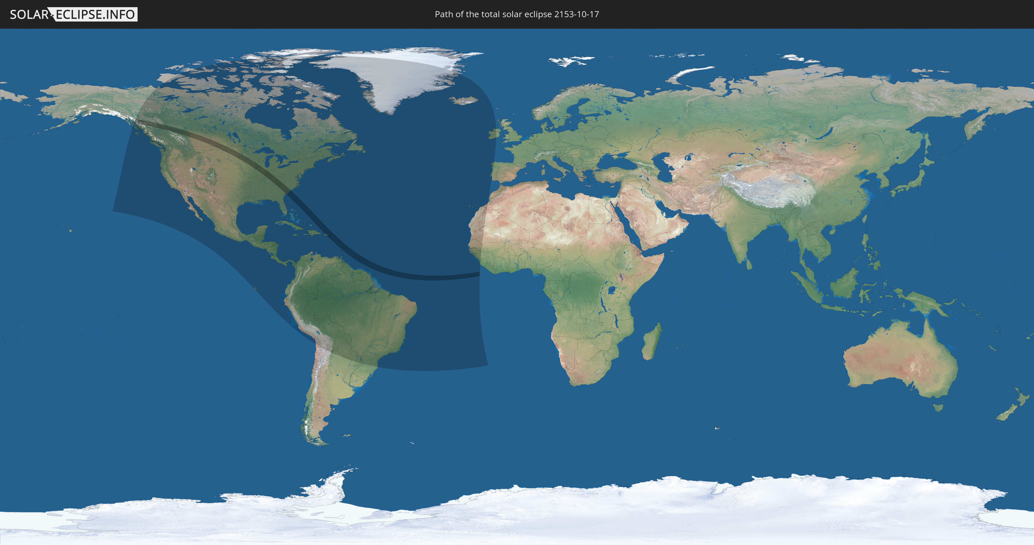
Die Sonnenfinsternis am 17.10.2153 kann man in 65 Ländern als partielle Sonnenfinsternis beobachten.
Der Finsternispfad verläuft durch 15 Länder. Nur in diesen Ländern ist sie als totale Sonnenfinsternis zu sehen.
In den folgenden Ländern ist die Sonnenfinsternis total zu sehen
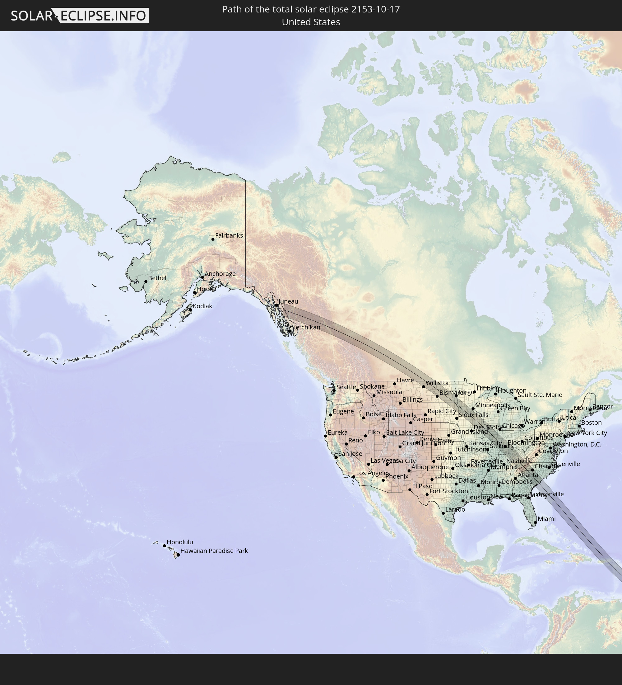 Vereinigte Staaten
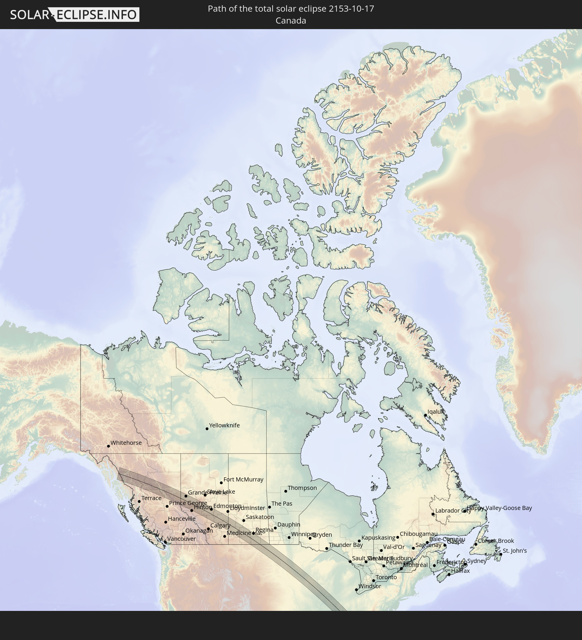 Kanada
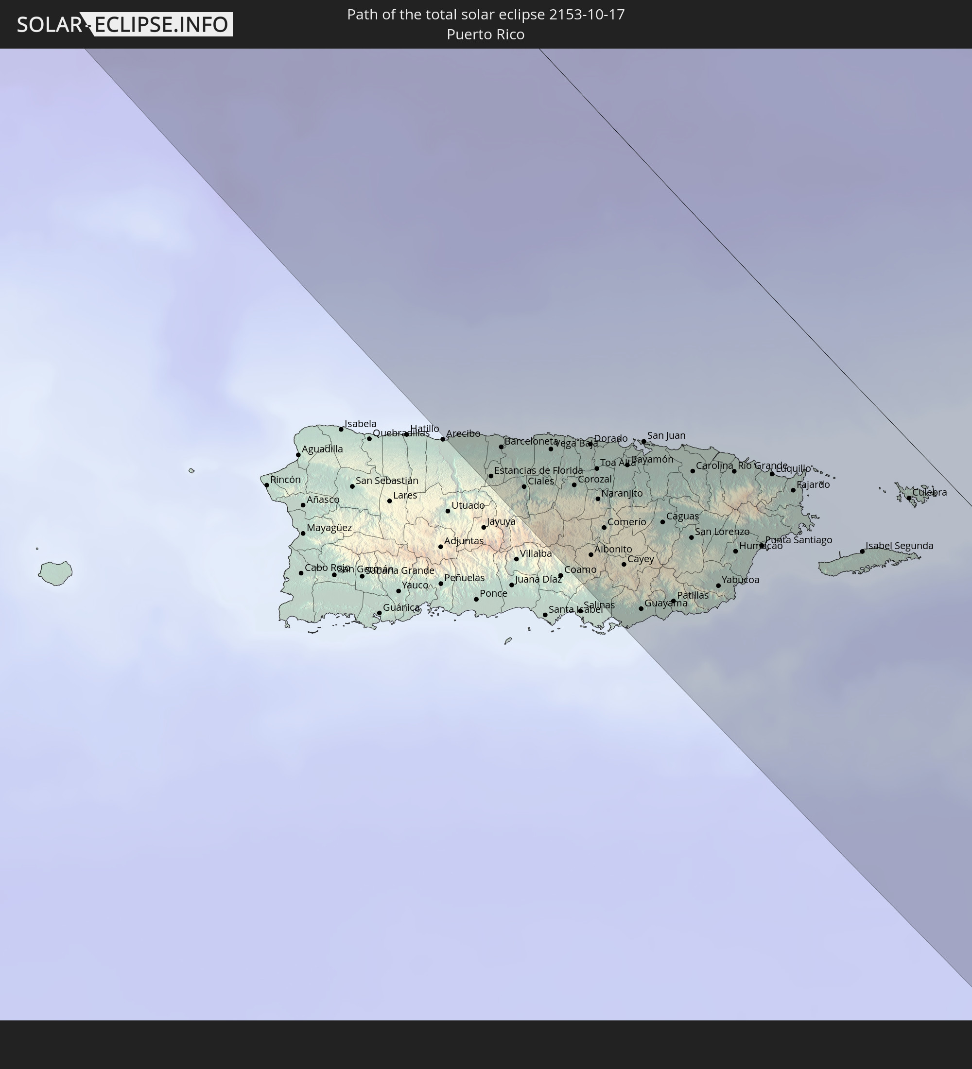 Puerto Rico
 Amerikanische Jungferninseln
 Britische Jungferninseln
 St. Kitts und Nevis
 Antigua und Barbuda
 Montserrat
 Guadeloupe
 Dominica
 St. Vincent und die Grenadinen
 Martinique
 St. Lucia
 Barbados
 Besondere Gemeinde (Niederlande)
In den folgenden Ländern ist die Sonnenfinsternis partiell zu sehen
 Vereinigte Staaten
 United States Minor Outlying Islands
 Kanada
 Mexiko
 Chile
Chile
 Grönland
 Guatemala
 Ecuador
 El Salvador
 Honduras
 Belize
 Nicaragua
 Costa Rica
 Kuba
Kuba
 Panama
 Kolumbien
 Kaimaninseln
 Peru
Peru
 Bahamas
 Jamaika
 Haiti
Haiti
 Brasilien
 Argentinien
 Venezuela
 Turks- und Caicosinseln
 Dominikanische Republik
 Aruba
Aruba
 Bolivien
 Puerto Rico
 Amerikanische Jungferninseln
 Bermuda
 Britische Jungferninseln
 Anguilla
 Saint-Martin
 Saint-Barthélemy
 St. Kitts und Nevis
 Paraguay
 Antigua und Barbuda
 Montserrat
 Trinidad und Tobago
 Guadeloupe
 Grenada
 Dominica
 St. Vincent und die Grenadinen
 Guyana
 Martinique
 St. Lucia
 Barbados
 Suriname
 Saint-Pierre und Miquelon
 Französisch-Guayana
 Portugal
 Kap Verde
 Island
 Spanien
 Senegal
 Mauretanien
 Gambia
 Guinea-Bissau
 Guinea
 St. Helena
 Sierra Leone
 Marokko
 Irland
 Vereinigtes Königreich
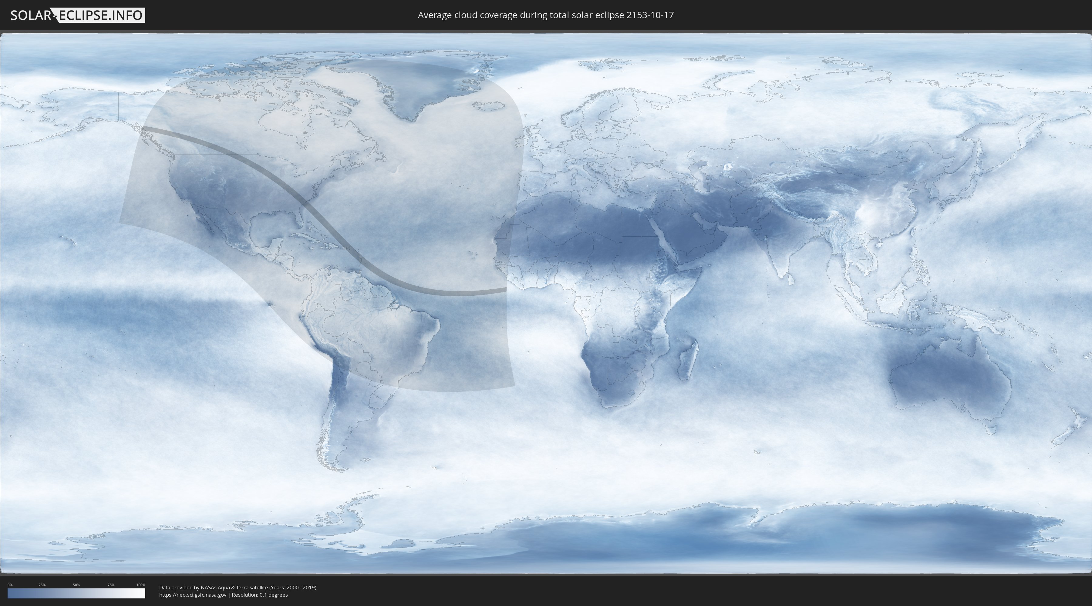
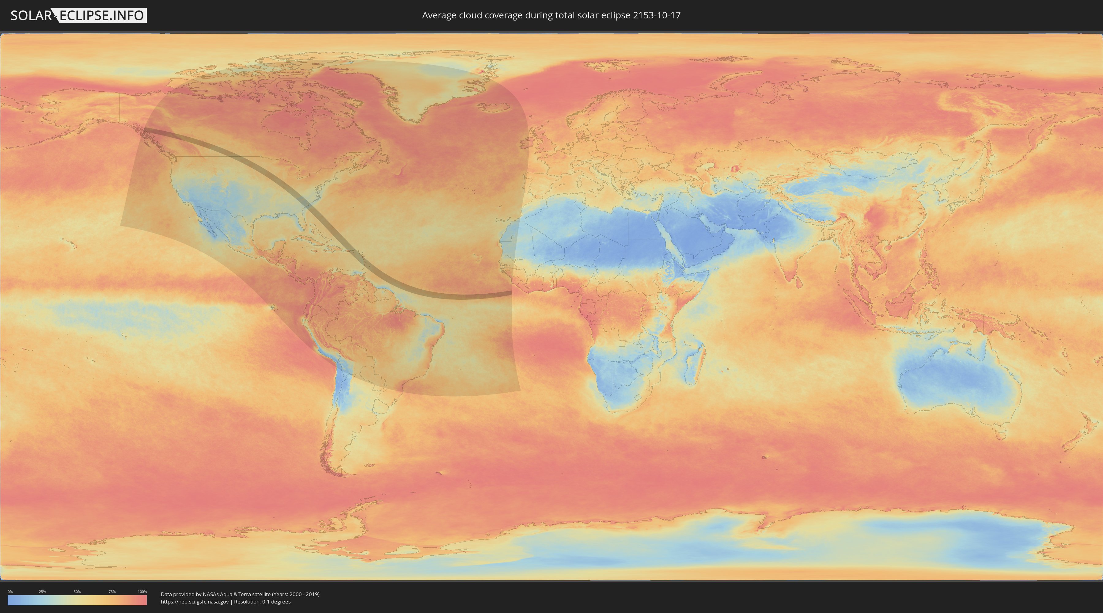
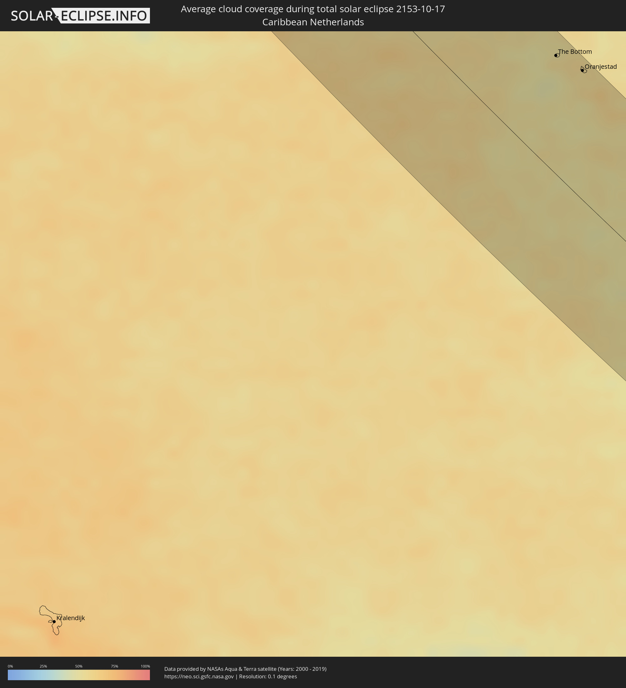
Wie wird das Wetter während der totalen Sonnenfinsternis am 17.10.2153?
Wo ist der beste Ort, um die totale Sonnenfinsternis vom 17.10.2153 zu beobachten?
Die folgenden Karten zeigen die durchschnittliche Bewölkung für den Tag, an dem die totale Sonnenfinsternis
stattfindet. Mit Hilfe der Karten lässt sich der Ort entlang des Finsternispfades eingrenzen,
der die besten Aussichen auf einen klaren wolkenfreien Himmel bietet.
Trotzdem muss man immer lokale Gegenenheiten beachten und sollte sich genau über das Wetter an seinem
gewählten Beobachtungsort informieren.
Die Daten stammen von den beiden NASA-Satelliten
AQUA und TERRA
und wurden über einen Zeitraum von 19 Jahren (2000 - 2019) gemittelt.
Detaillierte Länderkarten
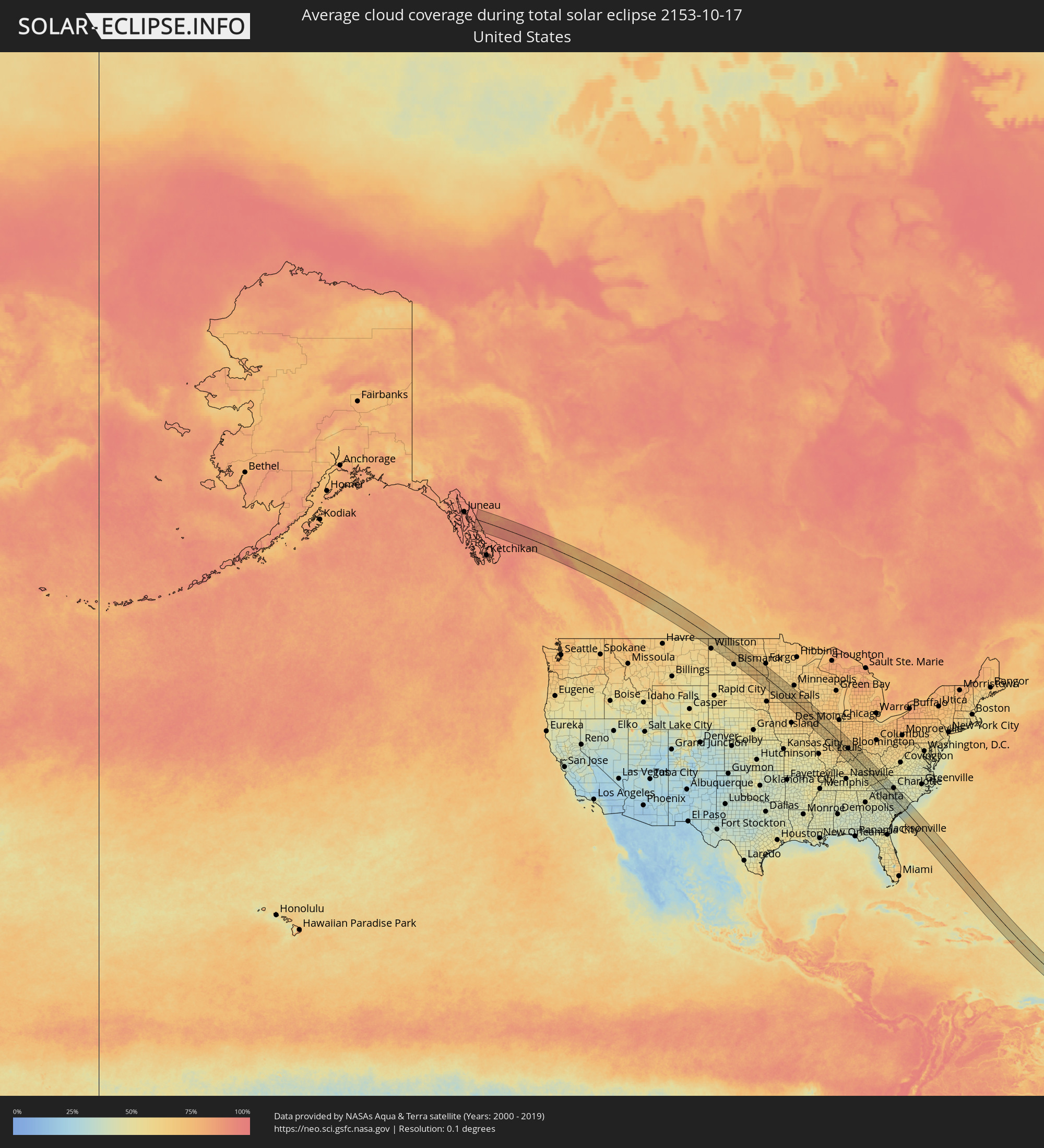 Vereinigte Staaten
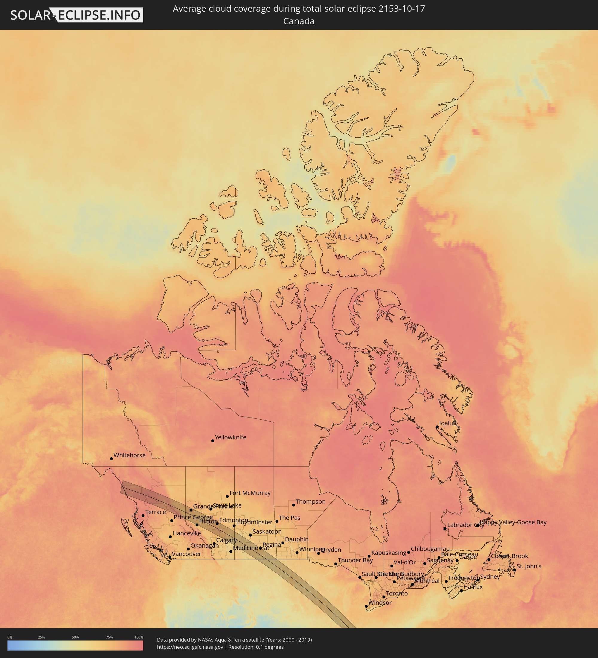 Kanada
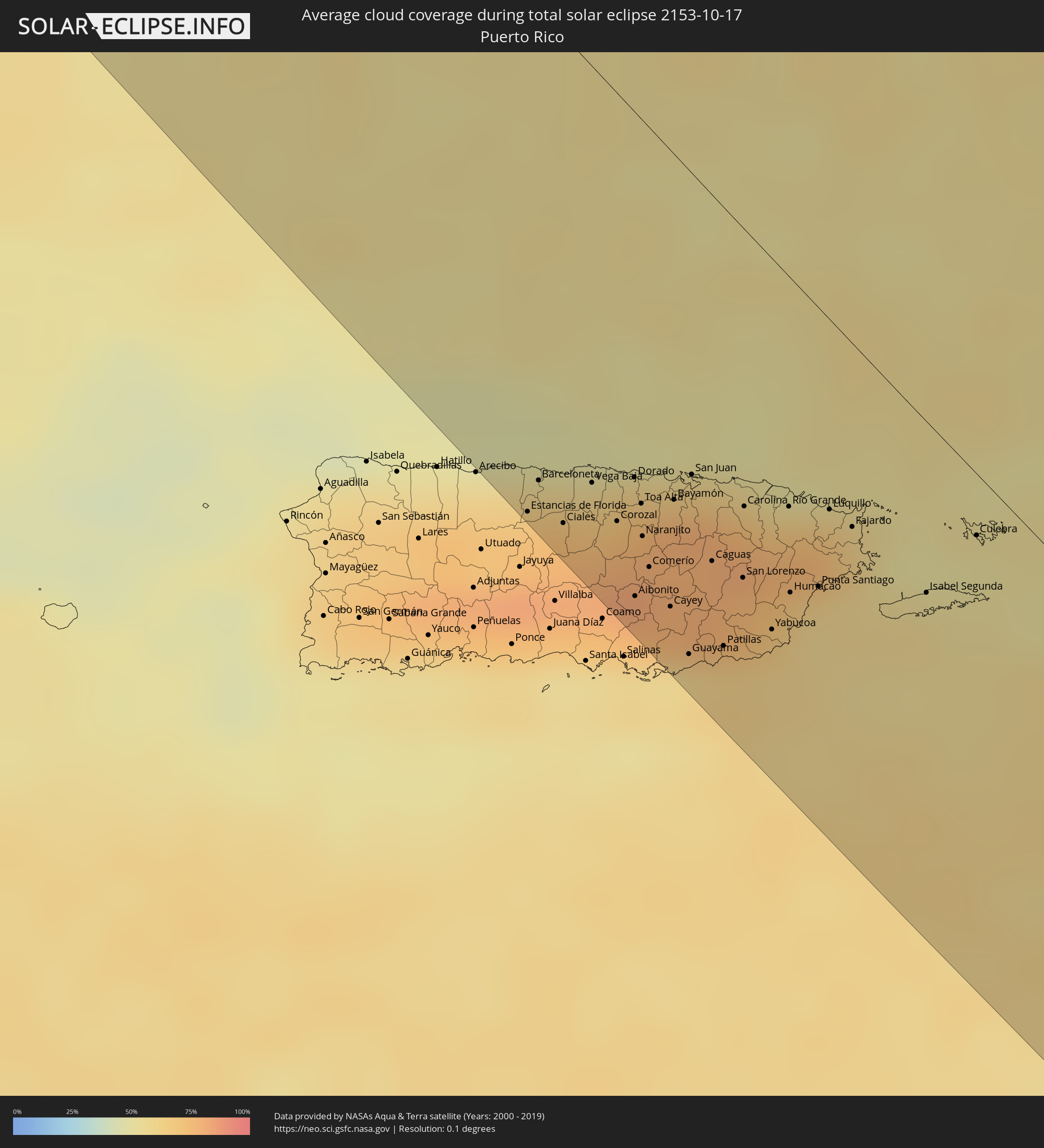 Puerto Rico
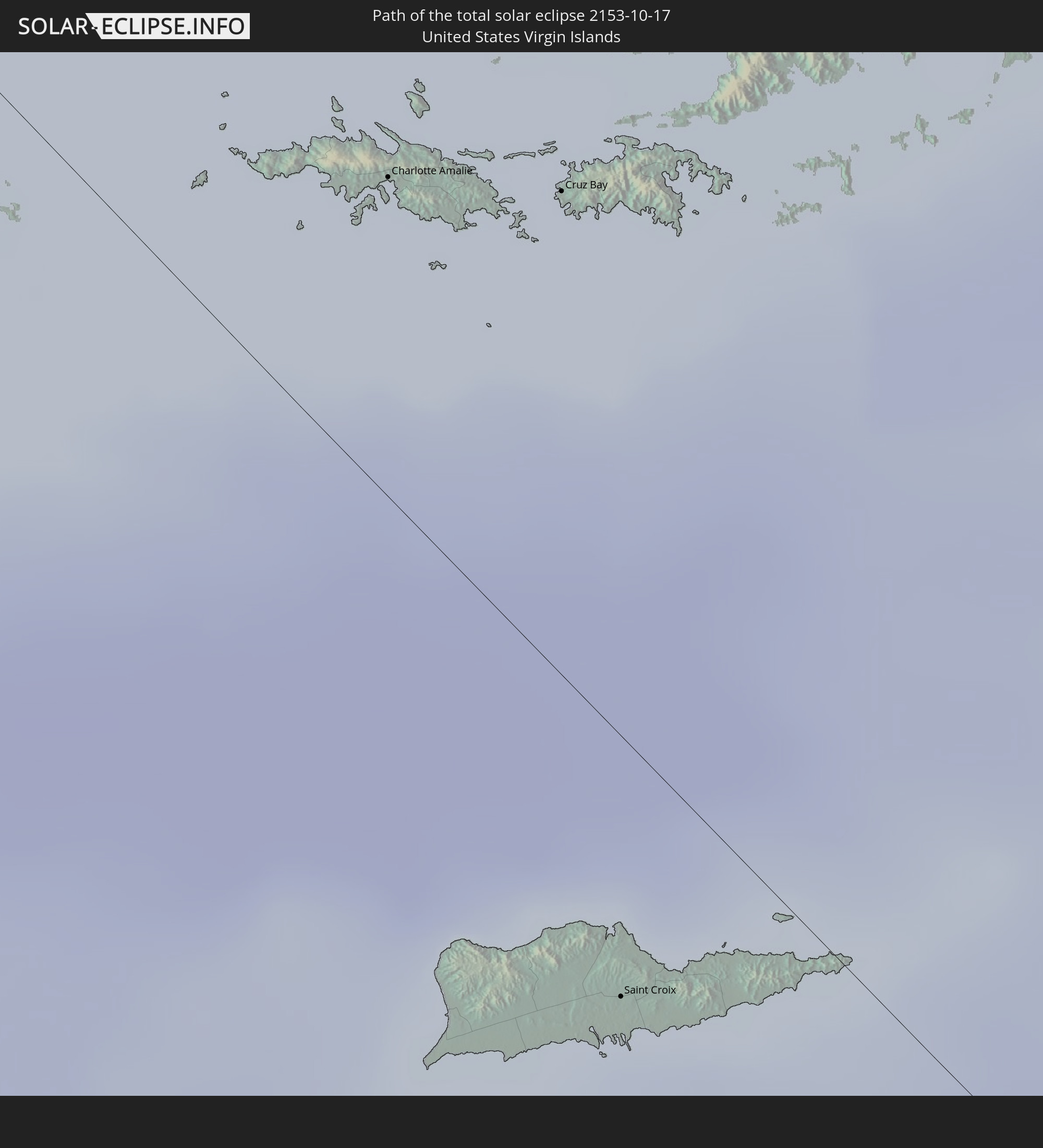
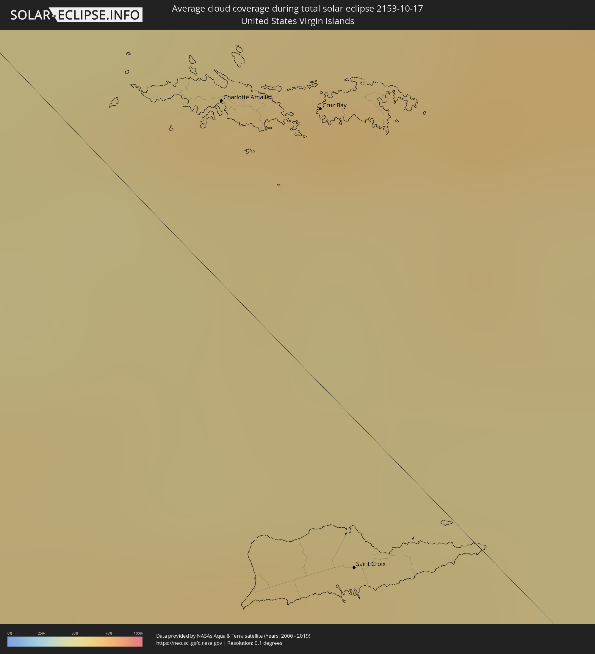 Amerikanische Jungferninseln
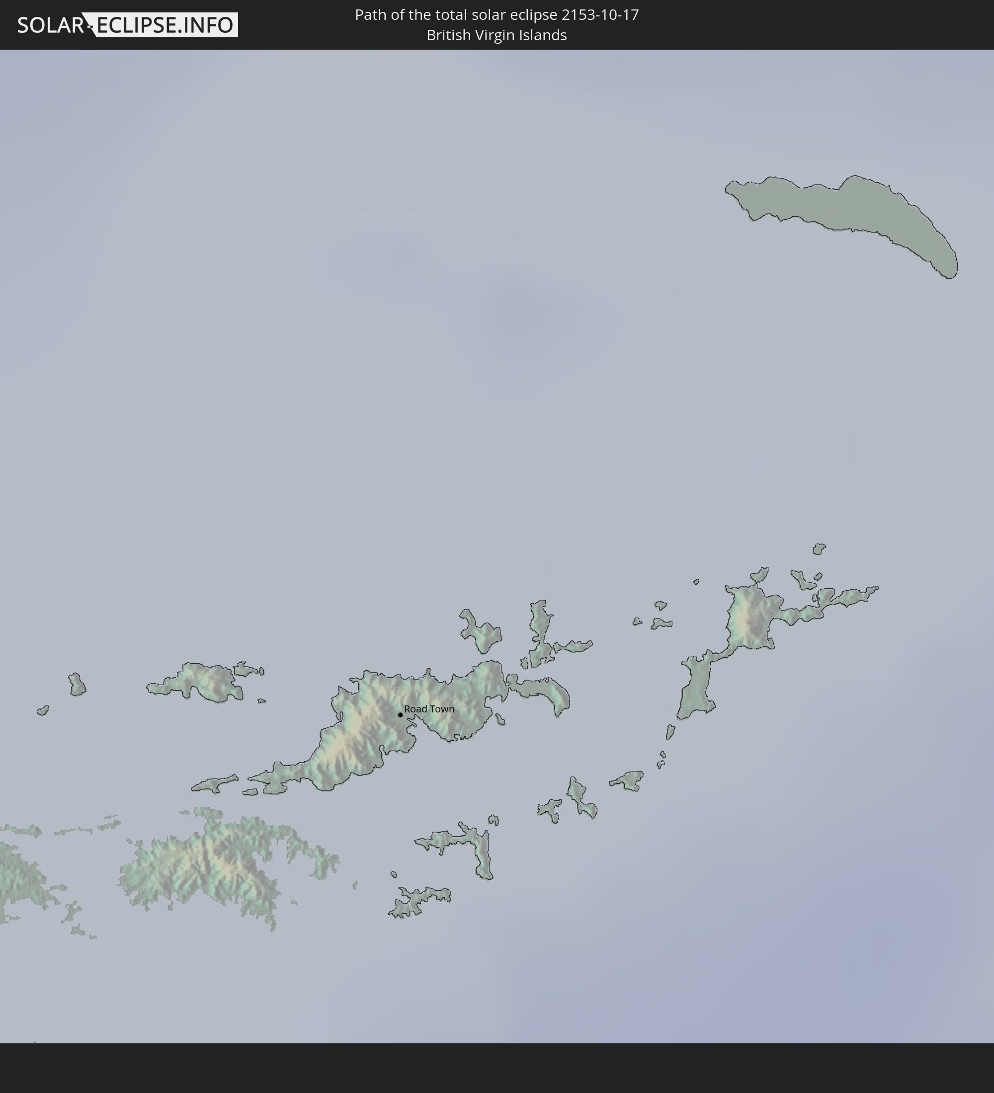
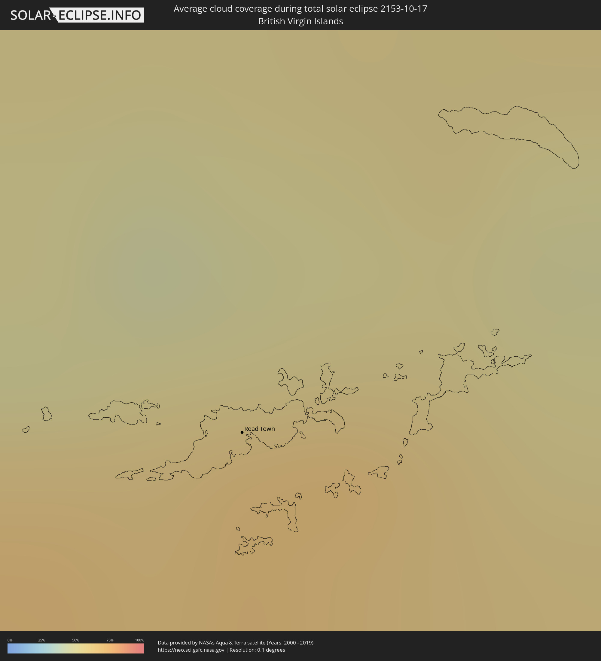 Britische Jungferninseln
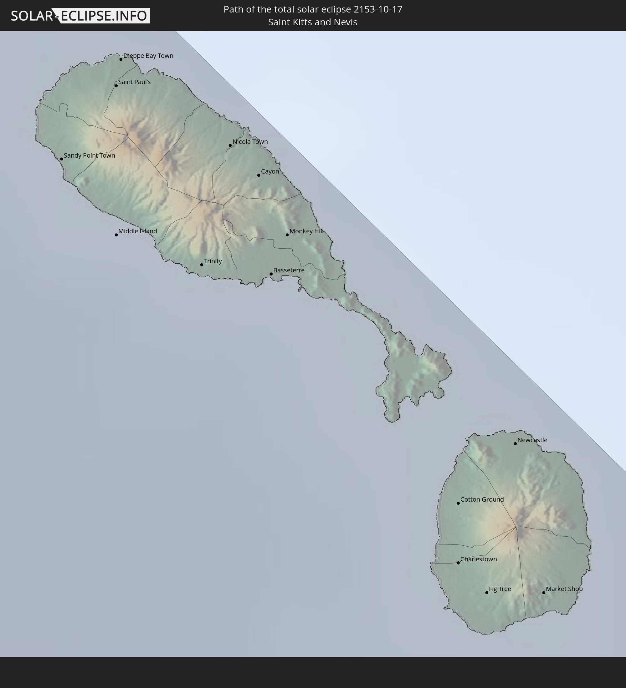
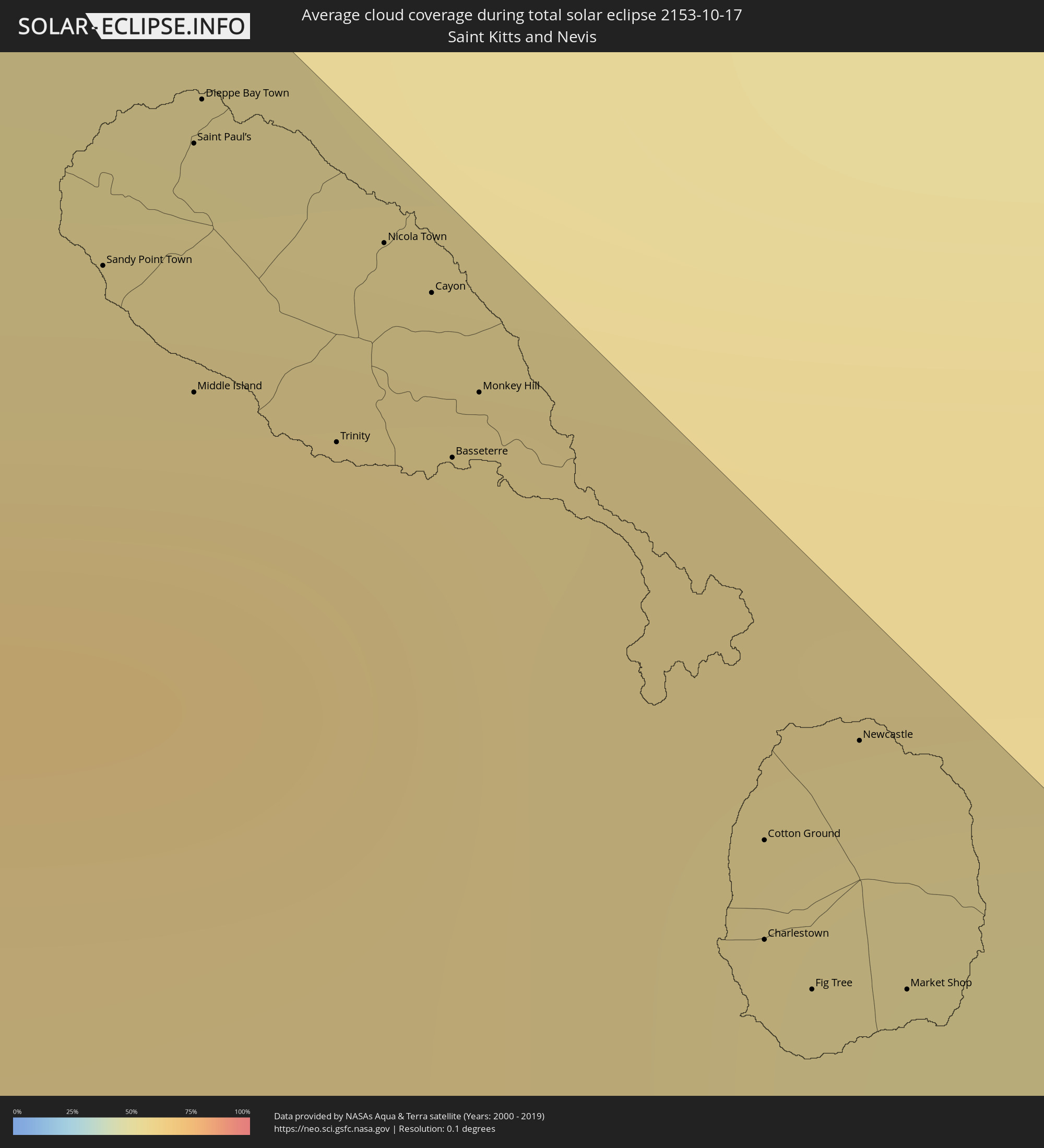 St. Kitts und Nevis
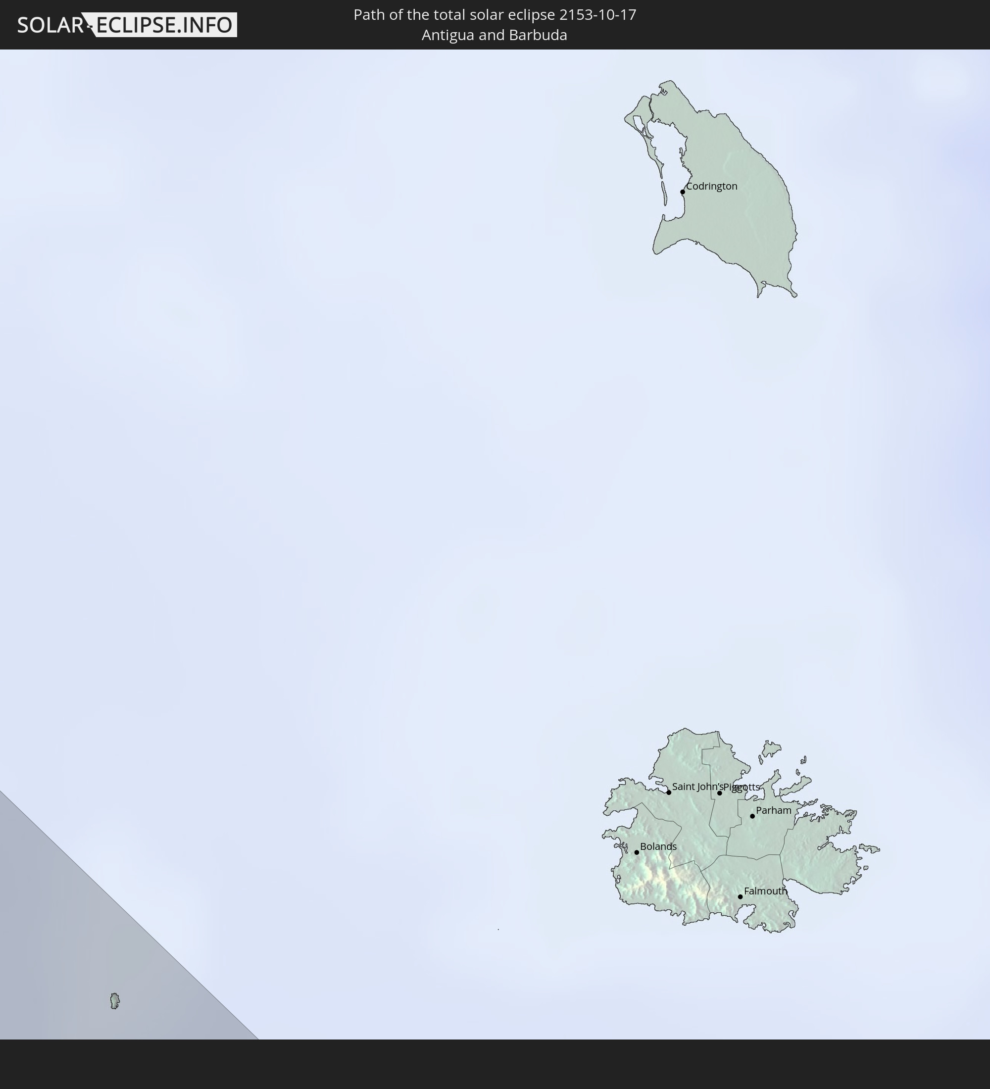
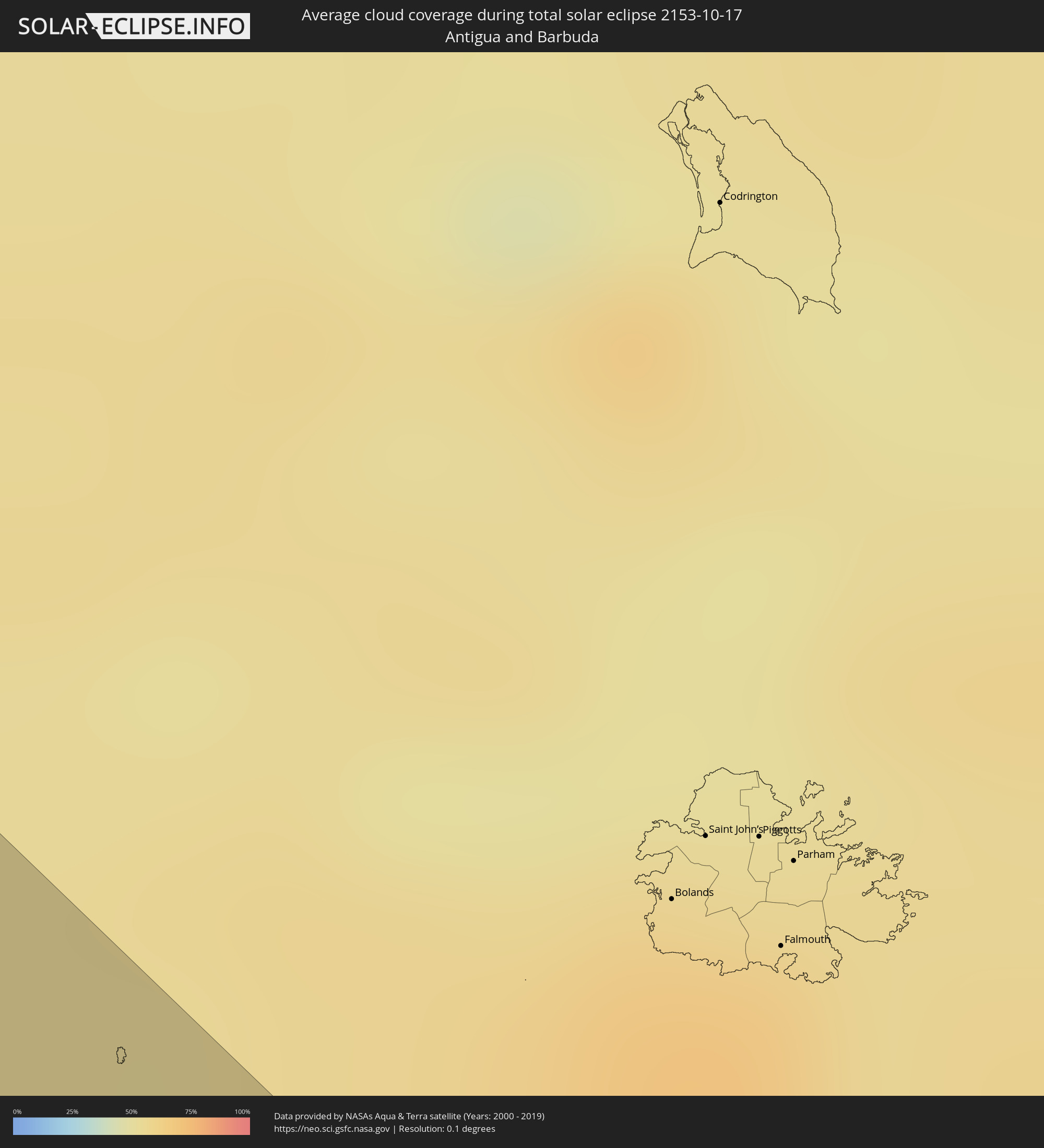 Antigua und Barbuda
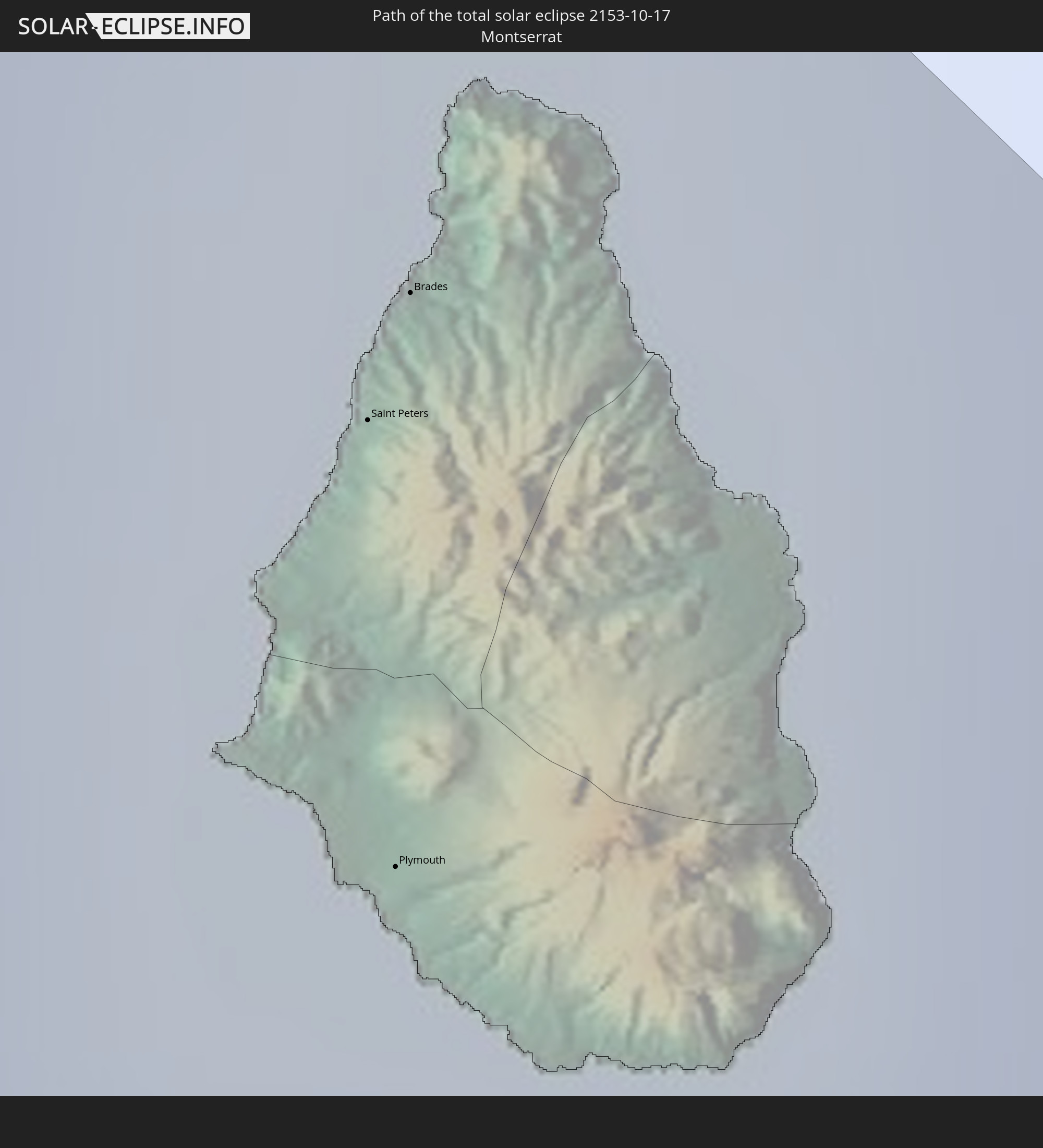
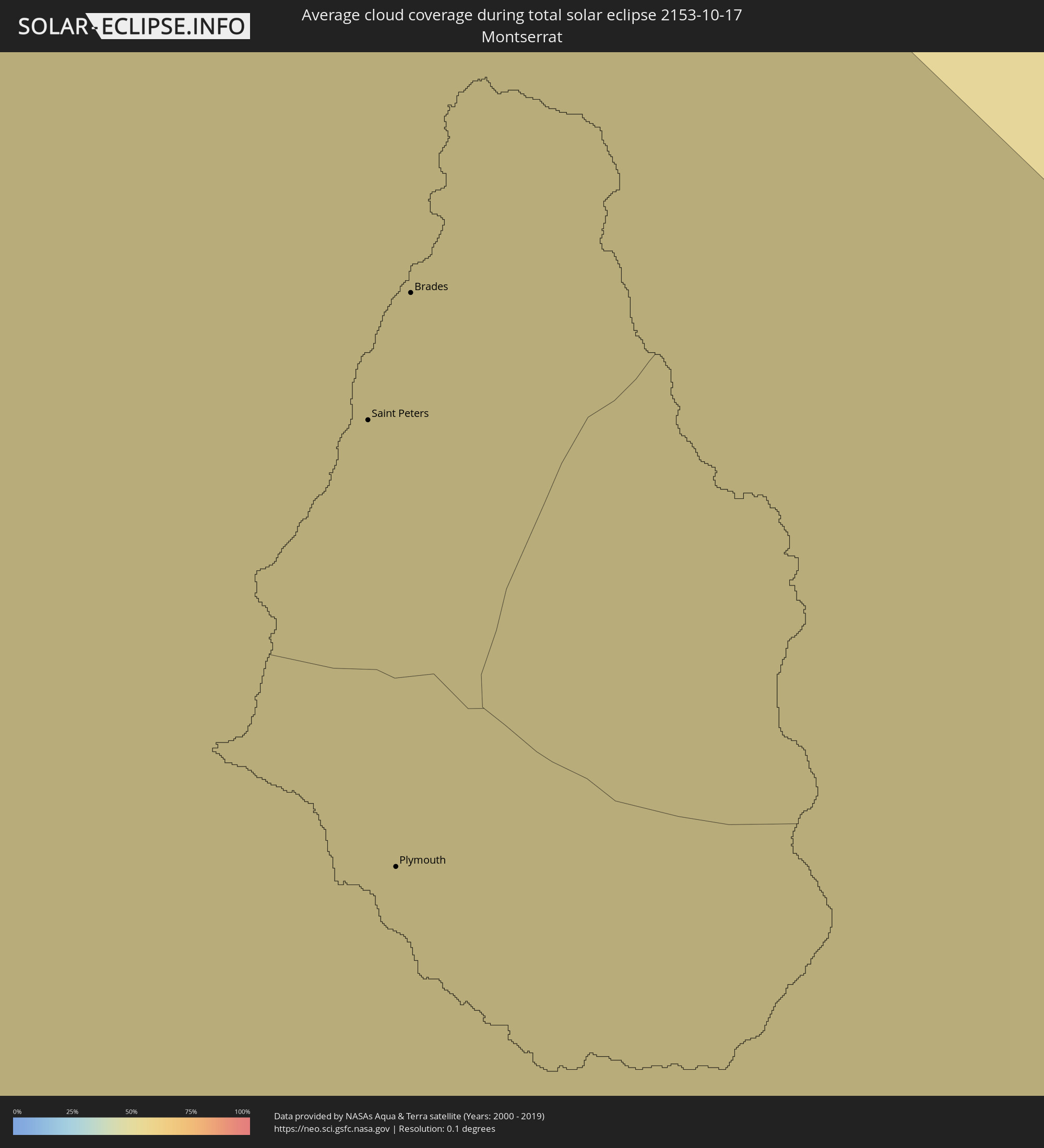 Montserrat
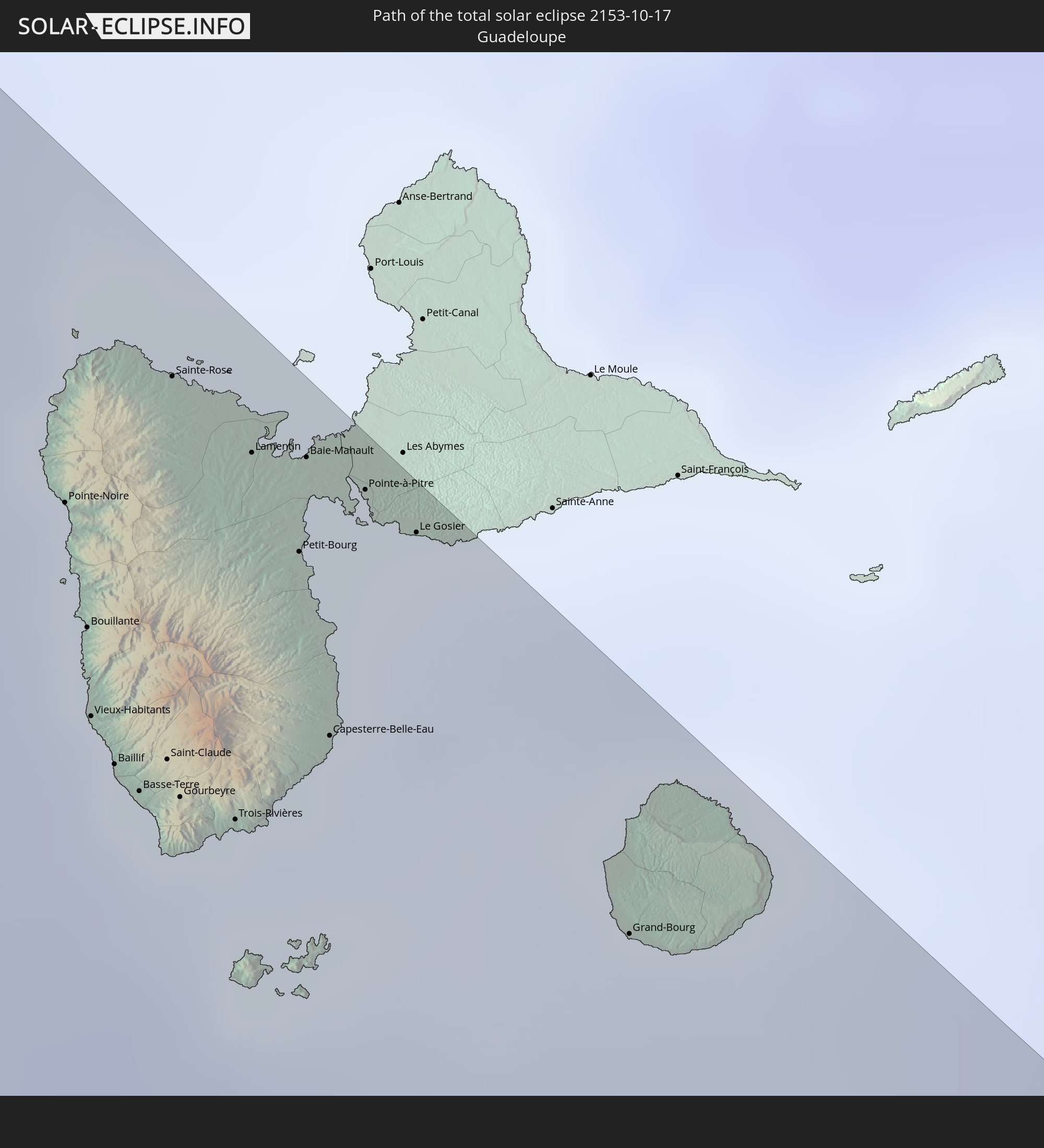
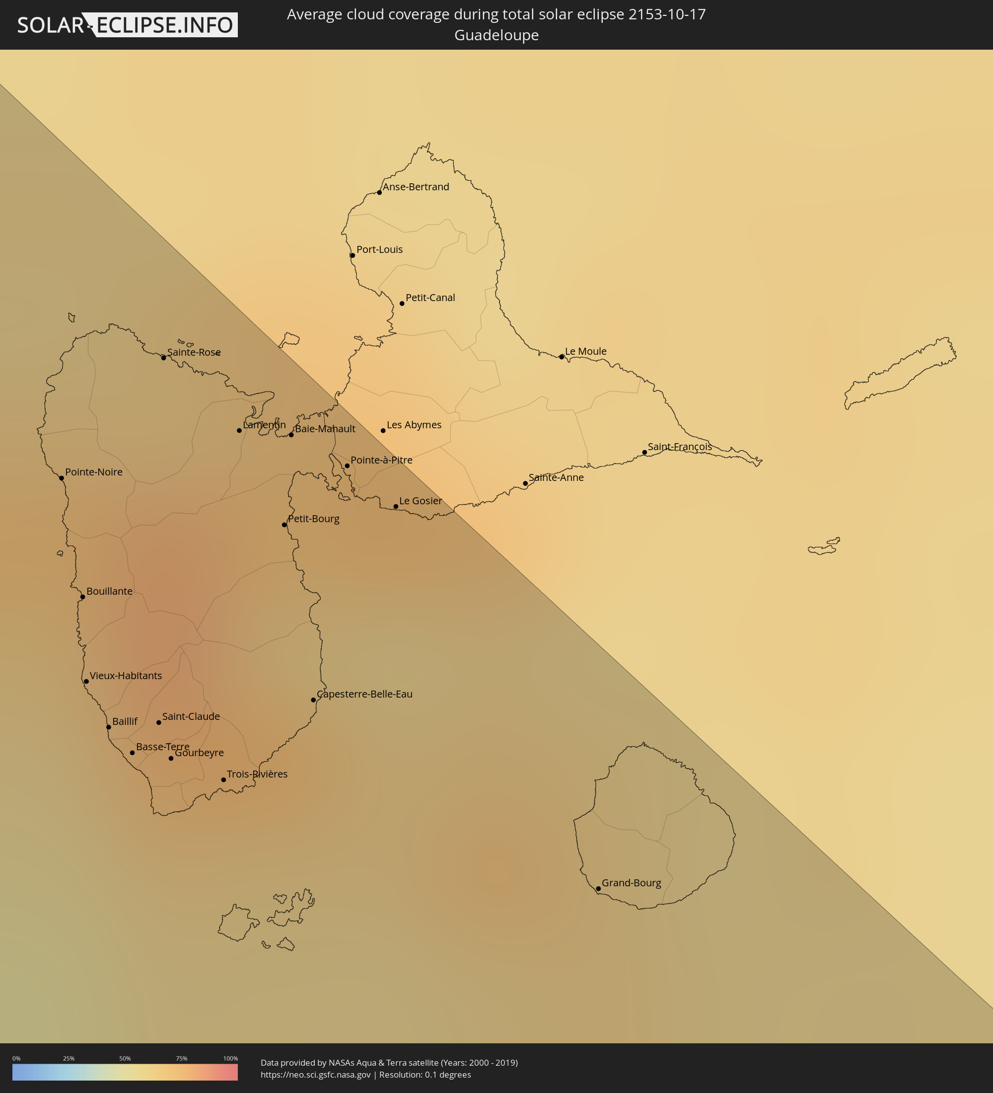 Guadeloupe
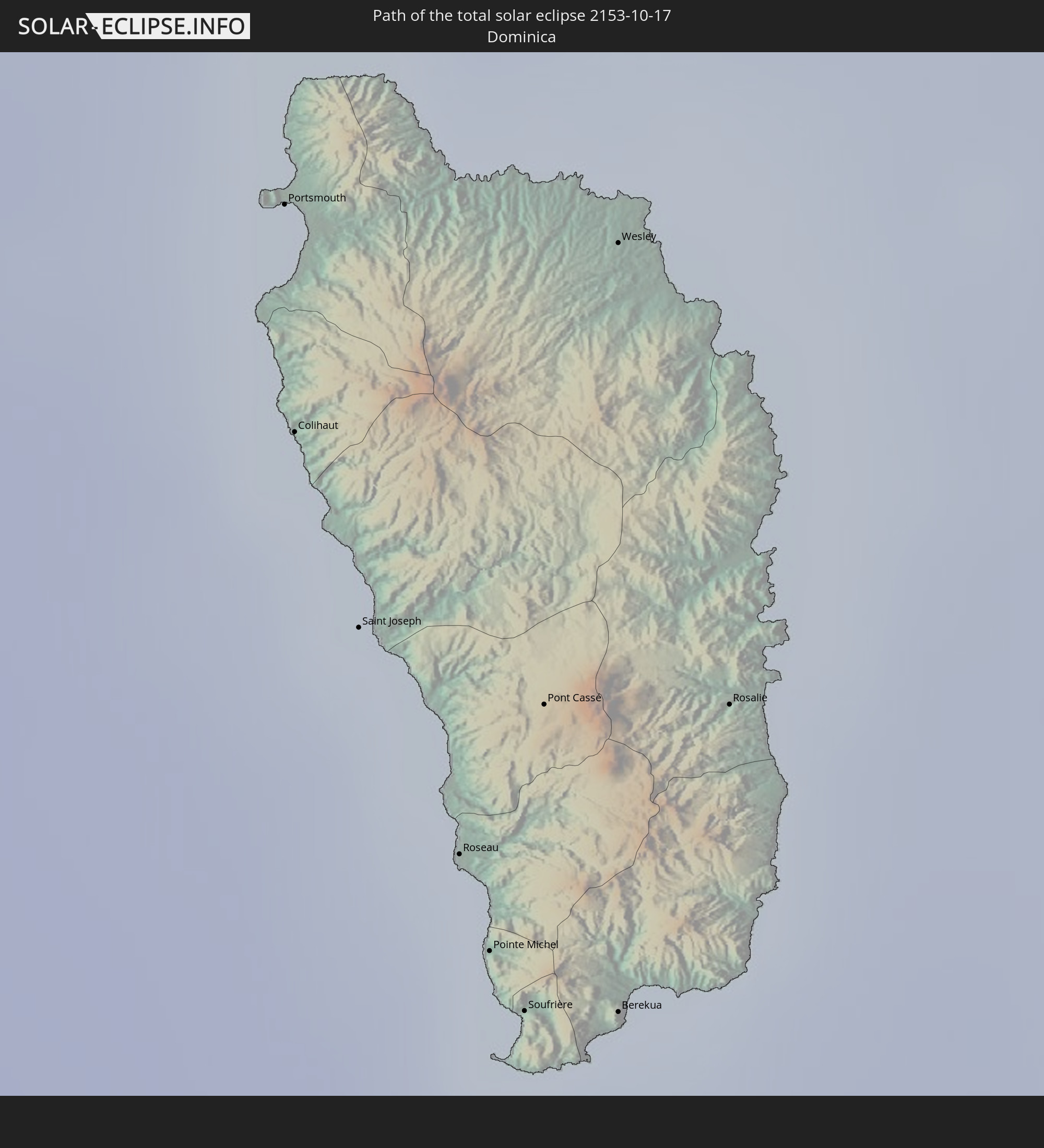
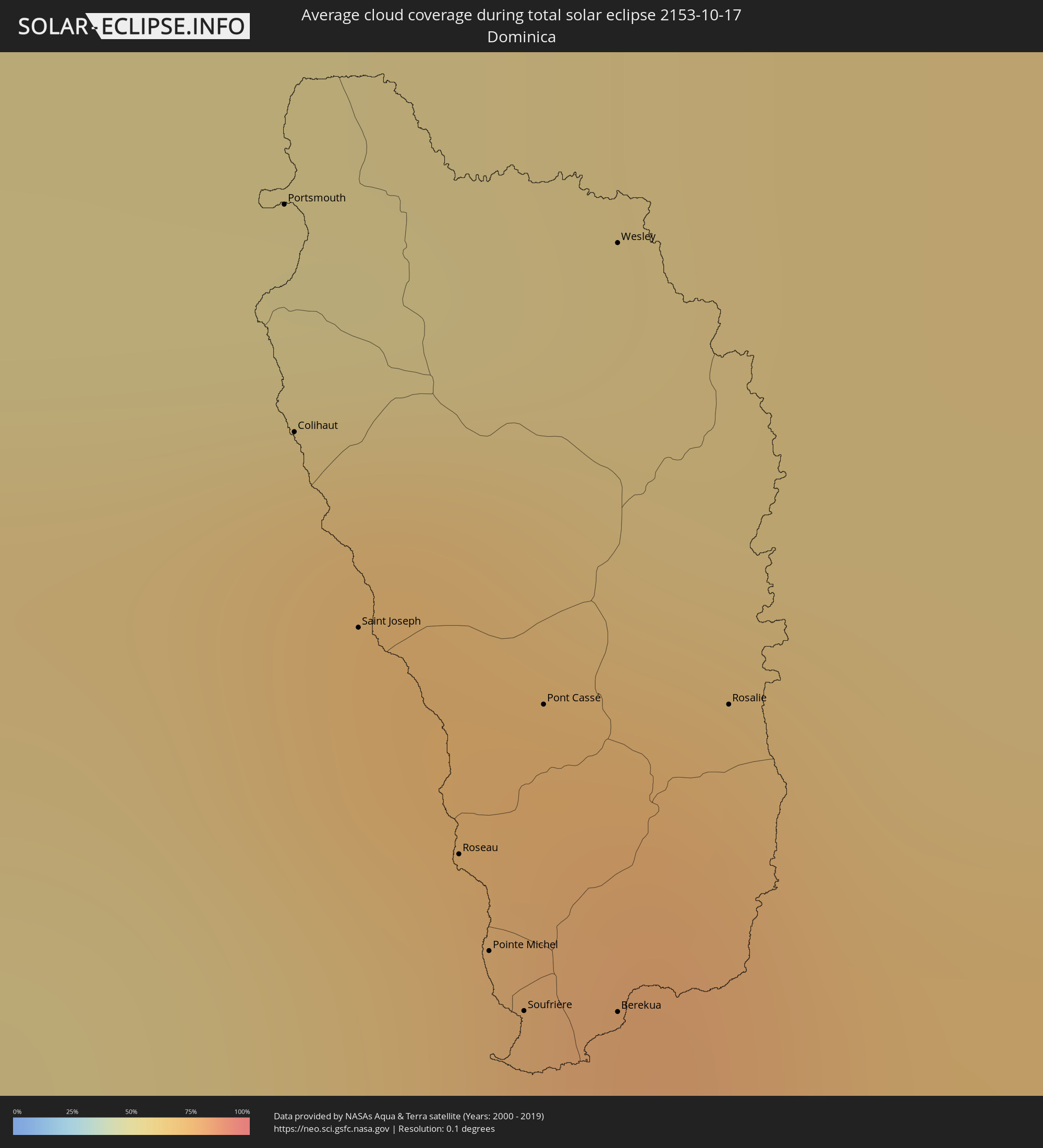 Dominica
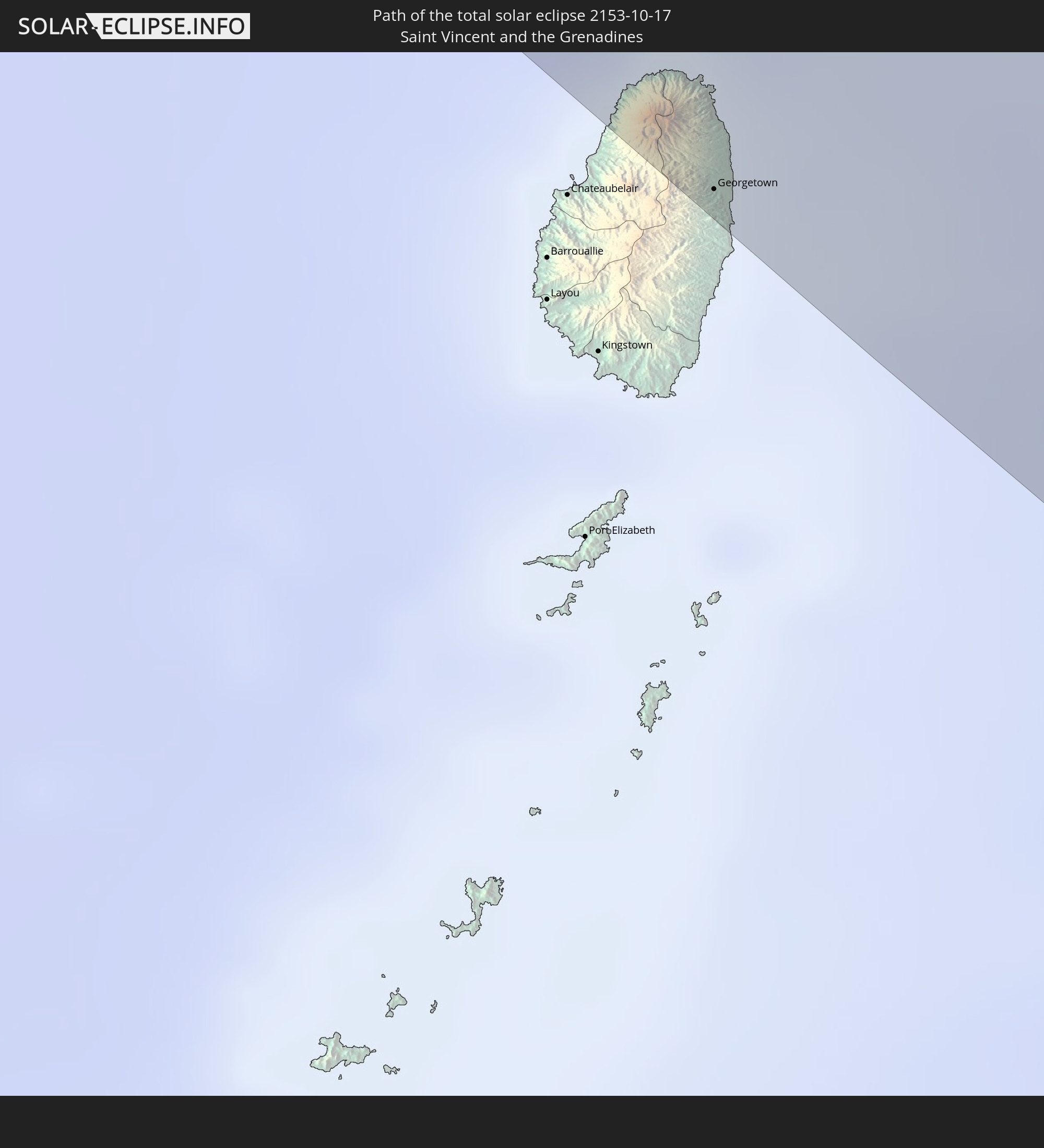
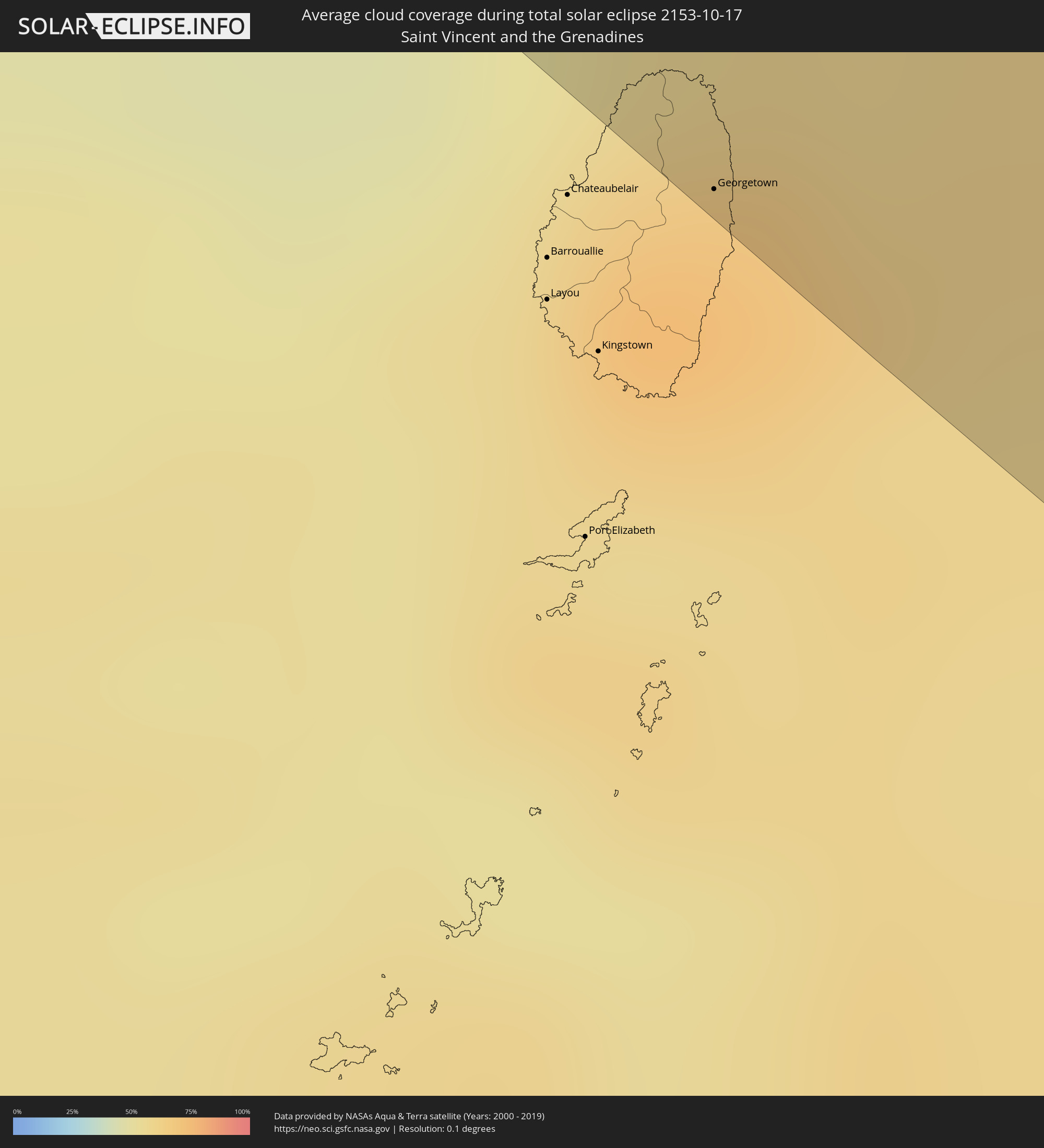 St. Vincent und die Grenadinen
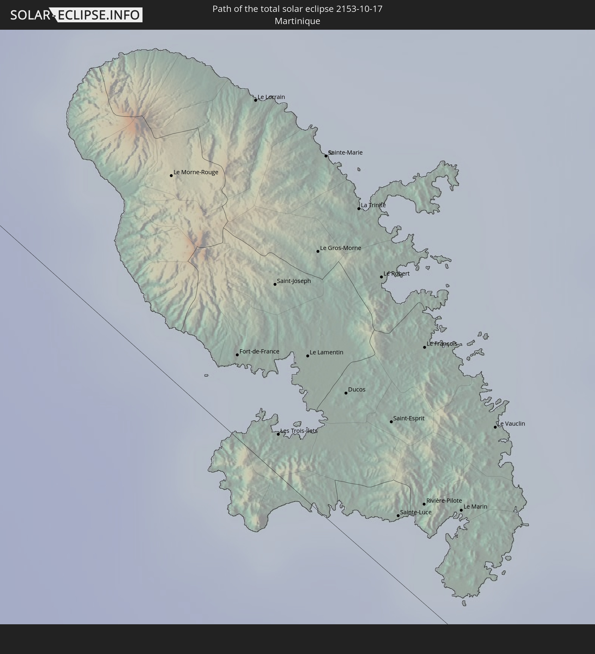
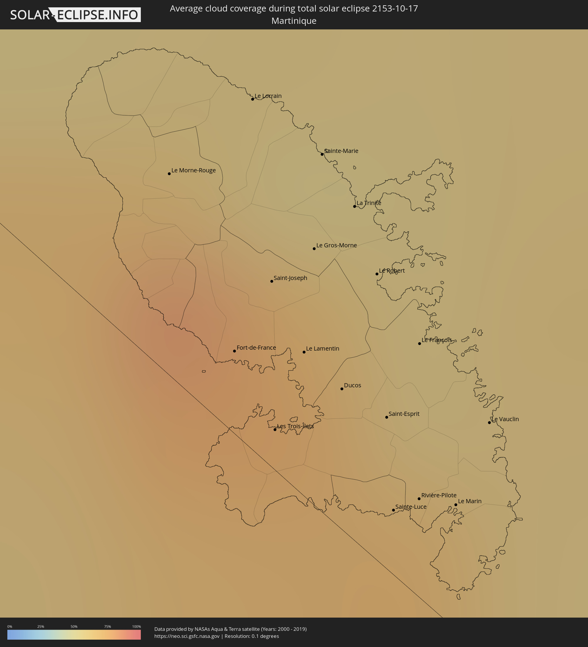 Martinique
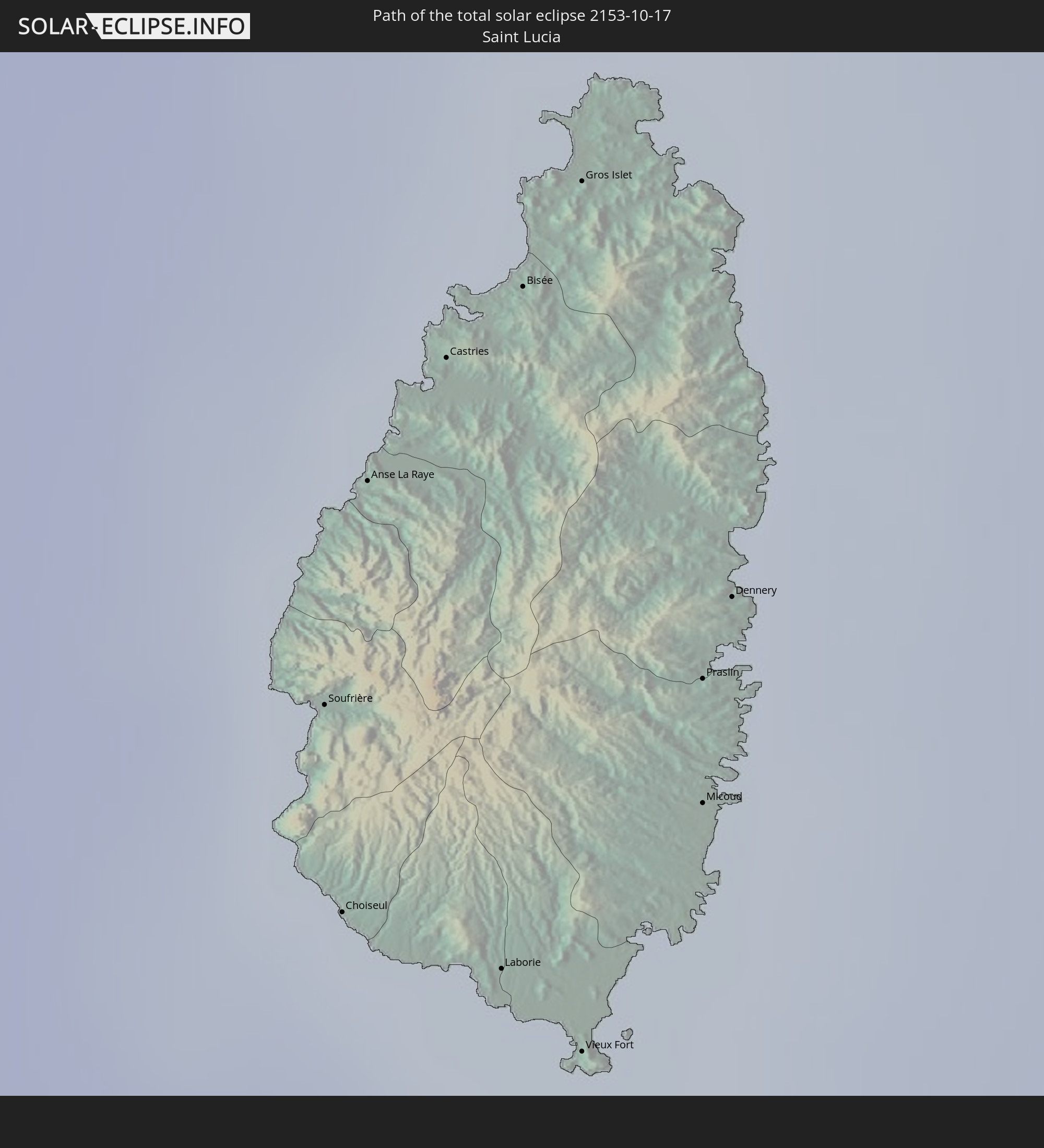
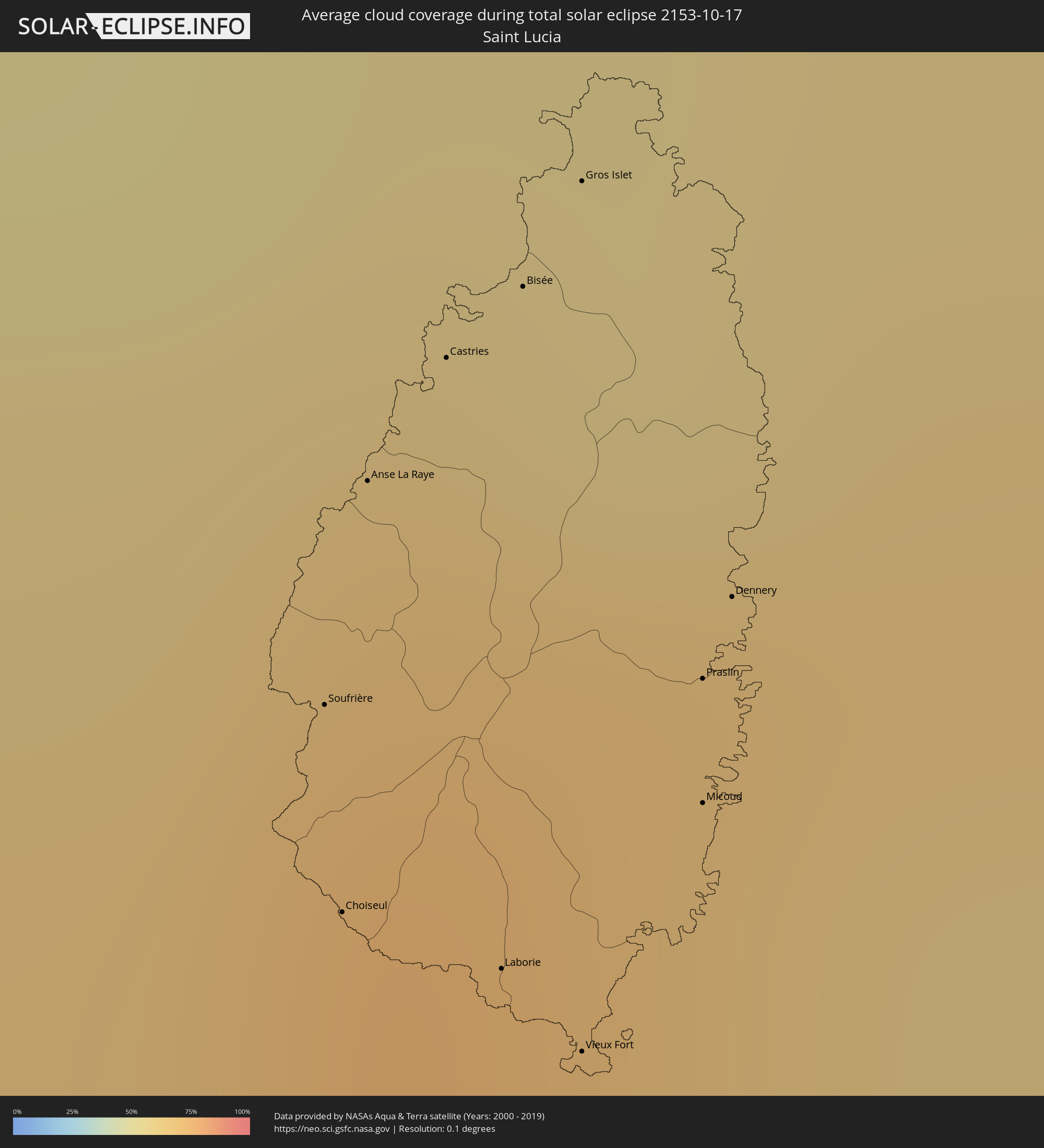 St. Lucia
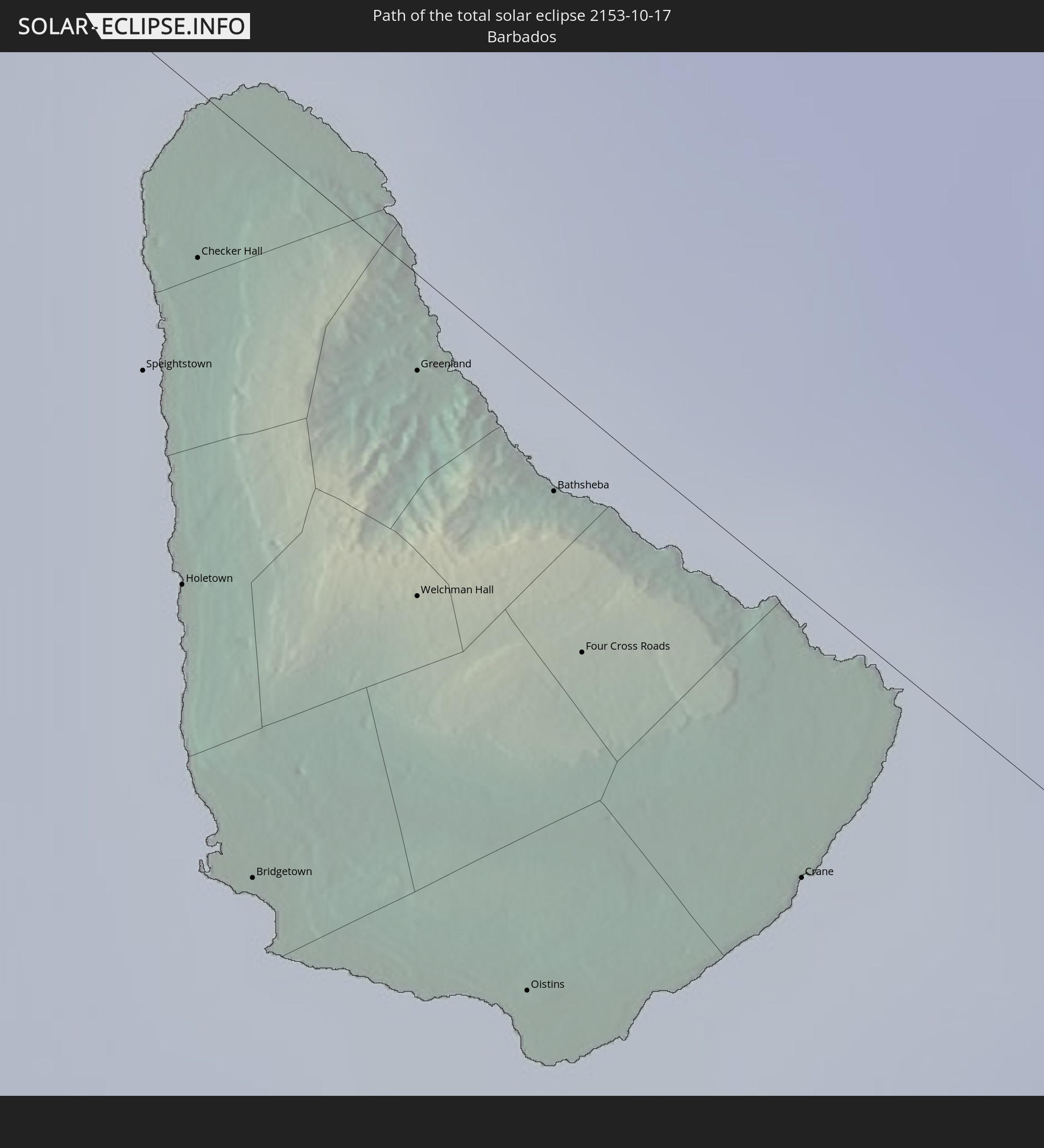
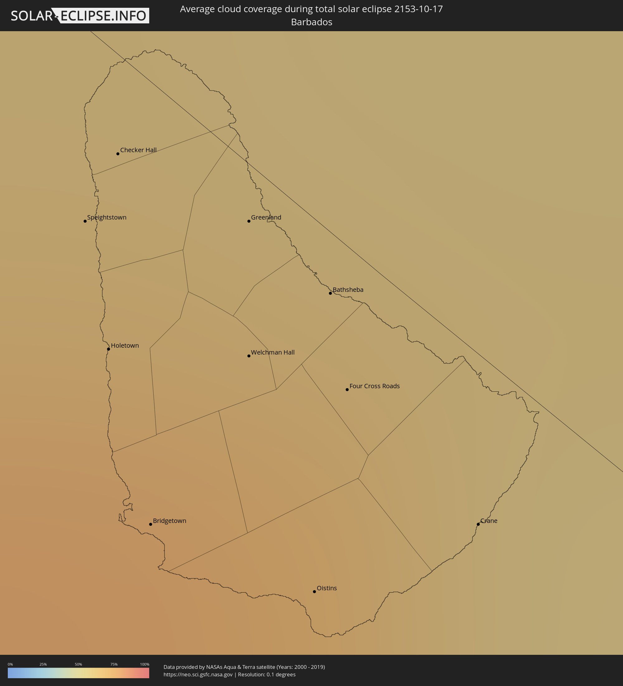 Barbados
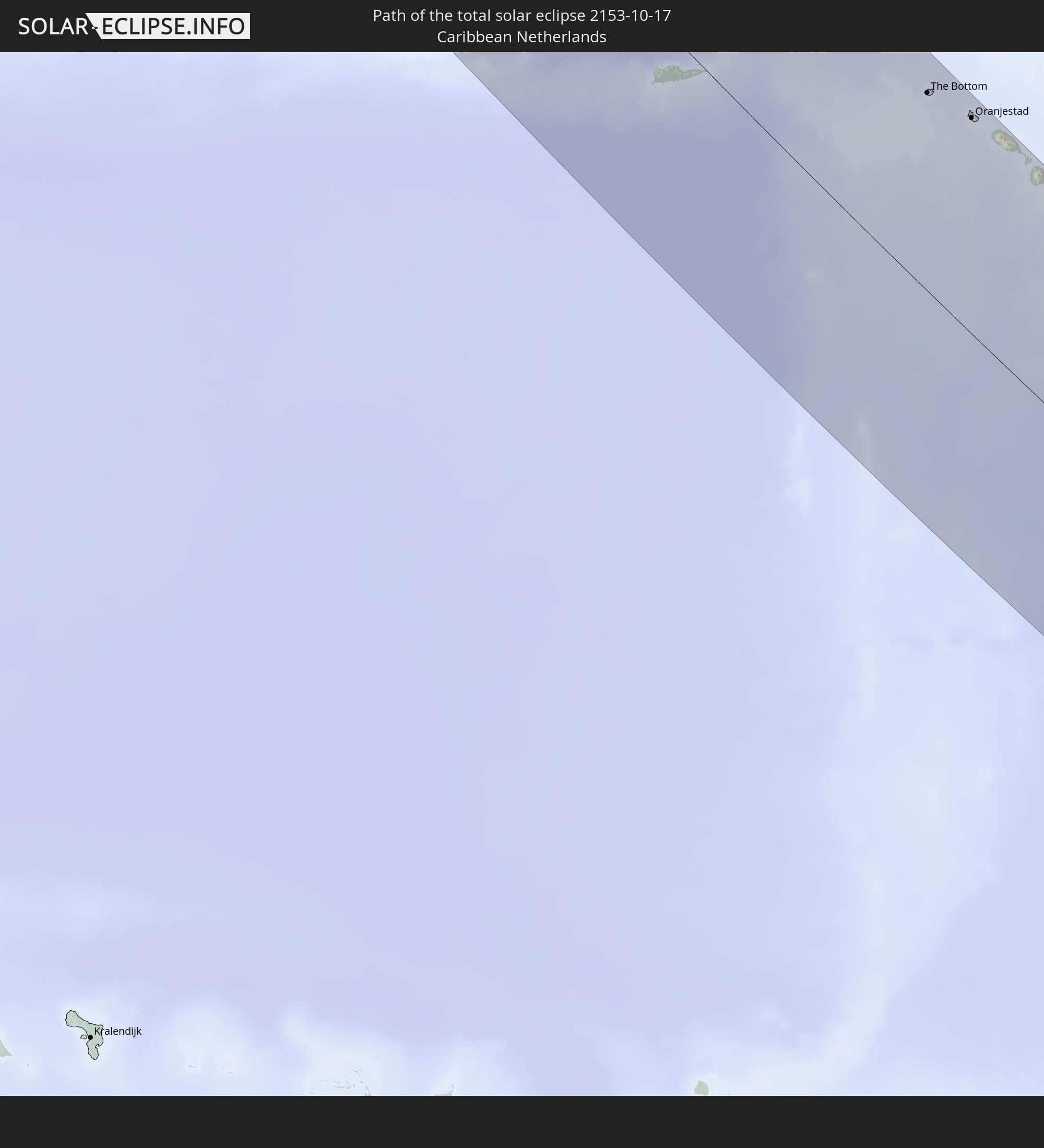
 Besondere Gemeinde (Niederlande)
Orte im Finsternispfad
Die nachfolgene Tabelle zeigt Städte und Orte mit mehr als 5.000 Einwohnern, die sich im Finsternispfad befinden. Städte mit mehr als 100.000 Einwohnern sind dick gekennzeichnet. Mit einem Klick auf den Ort öffnet sich eine Detailkarte die die Lage des jeweiligen Ortes zusammen mit dem Verlauf der zentralen Finsternis präsentiert.
| Ort | Typ | Dauer der Verfinsterung | Ortszeit bei maximaler Verfinsterung | Entfernung zur Zentrallinie | Ø Bewölkung |
|
Dawson Creek, British Columbia
|
total | - | 08:40:54 UTC-07:00 | 75 km | 79% |
|
Grande Prairie, Alberta
|
total | - | 08:41:02 UTC-07:00 | 55 km | 77% |
|
Spruce Grove, Alberta
|
total | - | 08:42:13 UTC-07:00 | 39 km | 77% |
|
Red Deer, Alberta
|
total | - | 08:41:38 UTC-07:00 | 80 km | 75% |
|
Lacombe, Alberta
|
total | - | 08:41:45 UTC-07:00 | 59 km | 78% |
|
Leduc, Alberta
|
total | - | 08:42:15 UTC-07:00 | 25 km | 79% |
|
Edmonton, Alberta
|
total | - | 08:42:27 UTC-07:00 | 55 km | 76% |
|
Wetaskiwin, Alberta
|
total | - | 08:42:12 UTC-07:00 | 2 km | 78% |
|
Fort Saskatchewan, Alberta
|
total | - | 08:42:39 UTC-07:00 | 80 km | 78% |
|
Camrose, Alberta
|
total | - | 08:42:29 UTC-07:00 | 24 km | 78% |
|
Swift Current, Saskatchewan
|
total | - | 09:44:17 UTC-06:00 | 59 km | 65% |
|
Moose Jaw, Saskatchewan
|
total | - | 09:45:49 UTC-06:00 | 39 km | 72% |
|
Regina, Saskatchewan
|
total | - | 09:46:28 UTC-06:00 | 80 km | 72% |
|
Weyburn, Saskatchewan
|
total | - | 09:46:49 UTC-06:00 | 39 km | 62% |
|
Estevan, Saskatchewan
|
total | - | 09:47:21 UTC-06:00 | 26 km | 62% |
|
Rochester, Minnesota
|
total | - | 09:56:56 UTC-06:00 | 77 km | 67% |
|
Cedar Rapids, Iowa
|
total | - | 09:58:26 UTC-06:00 | 47 km | 66% |
|
Davenport, Iowa
|
total | - | 09:59:49 UTC-06:00 | 27 km | 60% |
|
Peoria, Illinois
|
total | - | 10:01:20 UTC-06:00 | 39 km | 61% |
|
Bloomington, Illinois
|
total | - | 10:02:09 UTC-06:00 | 22 km | 67% |
|
Champaign, Illinois
|
total | - | 10:03:14 UTC-06:00 | 8 km | 65% |
|
Bloomington, Indiana
|
total | - | 11:05:55 UTC-05:00 | 19 km | 60% |
|
Indianapolis, Indiana
|
total | - | 11:06:01 UTC-05:00 | 89 km | 69% |
|
Louisville, Kentucky
|
total | - | 11:07:30 UTC-05:00 | 6 km | 58% |
|
Lexington-Fayette, Kentucky
|
total | - | 11:09:22 UTC-05:00 | 59 km | 57% |
|
Knoxville, Tennessee
|
total | - | 11:11:43 UTC-05:00 | 69 km | 48% |
|
Asheville, North Carolina
|
total | - | 11:13:57 UTC-05:00 | 7 km | 44% |
|
Columbia, South Carolina
|
total | - | 11:17:40 UTC-05:00 | 27 km | 40% |
|
Charlotte, North Carolina
|
total | - | 11:16:46 UTC-05:00 | 78 km | 46% |
|
Charleston, South Carolina
|
total | - | 11:20:36 UTC-05:00 | 43 km | 45% |
|
Barceloneta, Barceloneta
|
total | - | 13:05:44 UTC-04:00 | 96 km | 59% |
|
Vega Baja, Vega Baja
|
total | - | 13:06:02 UTC-04:00 | 85 km | 70% |
|
Toa Alta, Toa Alta
|
total | - | 13:06:25 UTC-04:00 | 78 km | 78% |
|
Comerío, Comerio
|
total | - | 13:06:46 UTC-04:00 | 90 km | 79% |
|
Pájaros, Toa Alta
|
total | - | 13:06:31 UTC-04:00 | 78 km | 78% |
|
Cayey, Cayey
|
total | - | 13:07:05 UTC-04:00 | 93 km | 76% |
|
Guayama, Guayama
|
total | - | 13:07:25 UTC-04:00 | 99 km | 62% |
|
San Juan, San Juan
|
total | - | 13:06:33 UTC-04:00 | 62 km | 64% |
|
Aguas Buenas, Aguas Buenas
|
total | - | 13:06:56 UTC-04:00 | 77 km | 79% |
|
Caguas, Caguas
|
total | - | 13:07:05 UTC-04:00 | 75 km | 77% |
|
Carolina, Carolina
|
total | - | 13:06:59 UTC-04:00 | 57 km | 75% |
|
Humacao, Humacao
|
total | - | 13:07:40 UTC-04:00 | 65 km | 59% |
|
Naguabo, Naguabo
|
total | - | 13:07:44 UTC-04:00 | 53 km | 59% |
|
Fajardo, Fajardo
|
total | - | 13:07:41 UTC-04:00 | 38 km | 66% |
|
Isabel Segunda, Vieques Municipality
|
total | - | 13:08:25 UTC-04:00 | 35 km | 54% |
|
Charlotte Amalie, Saint Thomas Island
|
total | - | 13:09:04 UTC-04:00 | 19 km | 57% |
|
Cruz Bay, Saint John Island
|
total | - | 13:09:21 UTC-04:00 | 28 km | 58% |
|
Saint Croix, Saint Croix Island
|
total | - | 13:10:33 UTC-04:00 | 15 km | 59% |
|
Road Town
|
total | - | 13:09:31 UTC-04:00 | 49 km | 65% |
") The Bottom, Saba
The Bottom, Saba
|
total | - | 13:13:40 UTC-04:00 | 90 km | 51% |
|
Oranjestad, Sint Eustatius
|
total | - | 13:14:28 UTC-04:00 | 99 km | 55% |
|
Sandy Point Town, Saint Anne Sandy Point
|
total | - | 13:14:57 UTC-04:00 | 99 km | 63% |
|
Saint Paul’s, Saint Paul Capesterre
|
total | - | 13:14:56 UTC-04:00 | 105 km | 63% |
|
Middle Island, Saint Thomas Middle Island
|
total | - | 13:15:06 UTC-04:00 | 98 km | 59% |
|
Dieppe Bay Town, Saint John Capesterre
|
total | - | 13:14:55 UTC-04:00 | 106 km | 63% |
|
Trinity, Trinity Palmetto Point
|
total | - | 13:15:13 UTC-04:00 | 100 km | 59% |
|
Nicola Town, Christ Church Nichola Town
|
total | - | 13:15:08 UTC-04:00 | 107 km | 63% |
|
Cayon, Saint Mary Cayon
|
total | - | 13:15:12 UTC-04:00 | 107 km | 57% |
|
Basseterre, Saint George Basseterre
|
total | - | 13:15:19 UTC-04:00 | 103 km | 57% |
|
Monkey Hill, Saint Peter Basseterre
|
total | - | 13:15:17 UTC-04:00 | 105 km | 57% |
|
Cotton Ground, Saint Thomas Lowland
|
total | - | 13:15:46 UTC-04:00 | 101 km | 60% |
|
Charlestown, Saint Paul Charlestown
|
total | - | 13:15:49 UTC-04:00 | 98 km | 54% |
|
Fig Tree, Saint John Figtree
|
total | - | 13:15:53 UTC-04:00 | 98 km | 54% |
|
Newcastle, Saint James Windwa
|
total | - | 13:15:46 UTC-04:00 | 106 km | 60% |
|
Market Shop, Saint George Gingerland
|
total | - | 13:15:57 UTC-04:00 | 101 km | 54% |
|
Saint Peters, Saint Peter
|
total | - | 13:17:17 UTC-04:00 | 99 km | 65% |
|
Plymouth, Saint Anthony
|
total | - | 13:17:25 UTC-04:00 | 94 km | 59% |
|
Brades, Saint Peter
|
total | - | 13:17:15 UTC-04:00 | 101 km | 65% |
|
Pointe-Noire, Guadeloupe
|
total | - | 13:19:08 UTC-04:00 | 87 km | 67% |
|
Bouillante, Guadeloupe
|
total | - | 13:19:21 UTC-04:00 | 80 km | 60% |
|
Vieux-Habitants, Guadeloupe
|
total | - | 13:19:29 UTC-04:00 | 75 km | 60% |
|
Baillif, Guadeloupe
|
total | - | 13:19:36 UTC-04:00 | 73 km | 63% |
|
Basse-Terre, Guadeloupe
|
total | - | 13:19:41 UTC-04:00 | 73 km | 63% |
|
Saint-Claude, Guadeloupe
|
total | - | 13:19:41 UTC-04:00 | 77 km | 63% |
|
Sainte-Rose, Guadeloupe
|
total | - | 13:19:07 UTC-04:00 | 102 km | 77% |
|
Gourbeyre, Guadeloupe
|
total | - | 13:19:46 UTC-04:00 | 75 km | 63% |
|
Trois-Rivières, Guadeloupe
|
total | - | 13:19:53 UTC-04:00 | 77 km | 63% |
|
Lamentin, Guadeloupe
|
total | - | 13:19:22 UTC-04:00 | 102 km | 72% |
|
Petit-Bourg, Guadeloupe
|
total | - | 13:19:35 UTC-04:00 | 98 km | 65% |
|
Baie-Mahault, Guadeloupe
|
total | - | 13:19:28 UTC-04:00 | 105 km | 72% |
|
Capesterre-Belle-Eau, Guadeloupe
|
total | - | 13:19:55 UTC-04:00 | 88 km | 63% |
|
Pointe-à-Pitre, Guadeloupe
|
total | - | 13:19:36 UTC-04:00 | 106 km | 60% |
|
Portsmouth, Saint John
|
total | - | 13:20:58 UTC-04:00 | 58 km | 63% |
|
Colihaut, Saint Peter
|
total | - | 13:21:09 UTC-04:00 | 50 km | 62% |
|
Saint Joseph, Saint Joseph
|
total | - | 13:21:22 UTC-04:00 | 45 km | 67% |
|
Roseau, Saint George
|
total | - | 13:21:39 UTC-04:00 | 41 km | 61% |
|
Pointe Michel, Saint Luke
|
total | - | 13:21:45 UTC-04:00 | 38 km | 61% |
|
Soufrière, Saint Mark
|
total | - | 13:21:50 UTC-04:00 | 37 km | 56% |
|
Pont Cassé, Saint Paul
|
total | - | 13:21:36 UTC-04:00 | 49 km | 67% |
|
Berekua, Saint Patrick
|
total | - | 13:21:55 UTC-04:00 | 40 km | 62% |
|
Wesley, Saint Andrew
|
total | - | 13:21:17 UTC-04:00 | 68 km | 63% |
|
Grand-Bourg, Guadeloupe
|
total | - | 13:20:42 UTC-04:00 | 94 km | 62% |
|
Rosalie, Saint David
|
total | - | 13:21:46 UTC-04:00 | 55 km | 79% |
|
Georgetown, Charlotte
|
total | - | 13:25:54 UTC-04:00 | 109 km | 70% |
|
Fort-de-France, Martinique
|
total | - | 13:23:33 UTC-04:00 | 6 km | 69% |
|
Le Lorrain, Martinique
|
total | - | 13:23:10 UTC-04:00 | 26 km | 81% |
|
Soufrière, Soufrière
|
total | - | 13:24:59 UTC-04:00 | 56 km | 66% |
|
Choiseul, Choiseul Quarter
|
total | - | 13:25:10 UTC-04:00 | 62 km | 65% |
|
Saint-Joseph, Martinique
|
total | - | 13:23:30 UTC-04:00 | 14 km | 75% |
|
Anse La Raye, Anse-la-Raye
|
total | - | 13:24:51 UTC-04:00 | 47 km | 75% |
|
Les Trois-Îlets, Martinique
|
total | - | 13:23:45 UTC-04:00 | 3 km | 63% |
|
Castries, Castries Quarter
|
total | - | 13:24:50 UTC-04:00 | 40 km | 69% |
|
Le Gros-Morne, Martinique
|
total | - | 13:23:32 UTC-04:00 | 19 km | 75% |
|
Sainte-Marie, Martinique
|
total | - | 13:23:23 UTC-04:00 | 26 km | 70% |
|
Laborie, Laborie Quarter
|
total | - | 13:25:20 UTC-04:00 | 59 km | 65% |
|
Ducos, Martinique
|
total | - | 13:23:49 UTC-04:00 | 10 km | 71% |
|
Bisée, Castries Quarter
|
total | - | 13:24:50 UTC-04:00 | 36 km | 69% |
|
La Trinité, Martinique
|
total | - | 13:23:32 UTC-04:00 | 25 km | 75% |
|
Vieux Fort, Vieux-Fort
|
total | - | 13:25:27 UTC-04:00 | 60 km | 59% |
|
Gros Islet, Gros-Islet
|
total | - | 13:24:48 UTC-04:00 | 30 km | 62% |
|
Le Robert, Martinique
|
total | - | 13:23:41 UTC-04:00 | 21 km | 60% |
|
Saint-Esprit, Martinique
|
total | - | 13:23:56 UTC-04:00 | 11 km | 70% |
|
Sainte-Luce, Martinique
|
total | - | 13:24:06 UTC-04:00 | 5 km | 66% |
|
Rivière-Pilote, Martinique
|
total | - | 13:24:08 UTC-04:00 | 7 km | 66% |
|
Le François, Martinique
|
total | - | 13:23:52 UTC-04:00 | 19 km | 70% |
|
Praslin, Praslin
|
total | - | 13:25:17 UTC-04:00 | 44 km | 69% |
|
Micoud, Micoud Quarter
|
total | - | 13:25:22 UTC-04:00 | 48 km | 65% |
|
Dennery, Dennery Quarter
|
total | - | 13:25:14 UTC-04:00 | 40 km | 69% |
|
Le Marin, Martinique
|
total | - | 13:24:12 UTC-04:00 | 9 km | 66% |
|
Le Vauclin, Martinique
|
total | - | 13:24:08 UTC-04:00 | 18 km | 60% |
|
Speightstown, Saint Peter
|
total | - | 13:28:52 UTC-04:00 | 8 km | 71% |
|
Holetown, Saint James
|
total | - | 13:29:01 UTC-04:00 | 13 km | 76% |
|
Checker Hall, Saint Lucy
|
total | - | 13:28:51 UTC-04:00 | 4 km | 67% |
|
Bridgetown, Saint Michael
|
total | - | 13:29:13 UTC-04:00 | 19 km | 68% |
|
Welchman Hall, Saint Thomas
|
total | - | 13:29:10 UTC-04:00 | 8 km | 76% |
|
Greenland, Saint Andrew
|
total | - | 13:29:02 UTC-04:00 | 2 km | 67% |
|
Oistins, Christ Church
|
total | - | 13:29:26 UTC-04:00 | 16 km | 66% |
|
Bathsheba, Saint Joseph
|
total | - | 13:29:11 UTC-04:00 | 3 km | 71% |
|
Four Cross Roads, Saint John
|
total | - | 13:29:17 UTC-04:00 | 6 km | 71% |
|
Crane, Saint Philip
|
total | - | 13:29:32 UTC-04:00 | 7 km | 66% |