Totale Sonnenfinsternis vom 16.05.2227
| Wochentag: | Mittwoch |
| Maximale Dauer der Verfinsterung: | 00m59s |
| Maximale Breite des Finsternispfades: | 63 km |
| Saroszyklus: | 151 |
| Bedeckungsgrad: | 100% |
| Magnitude: | 1.0135 |
| Gamma: | 0.6774 |
Wo kann man die Sonnenfinsternis vom 16.05.2227 sehen?
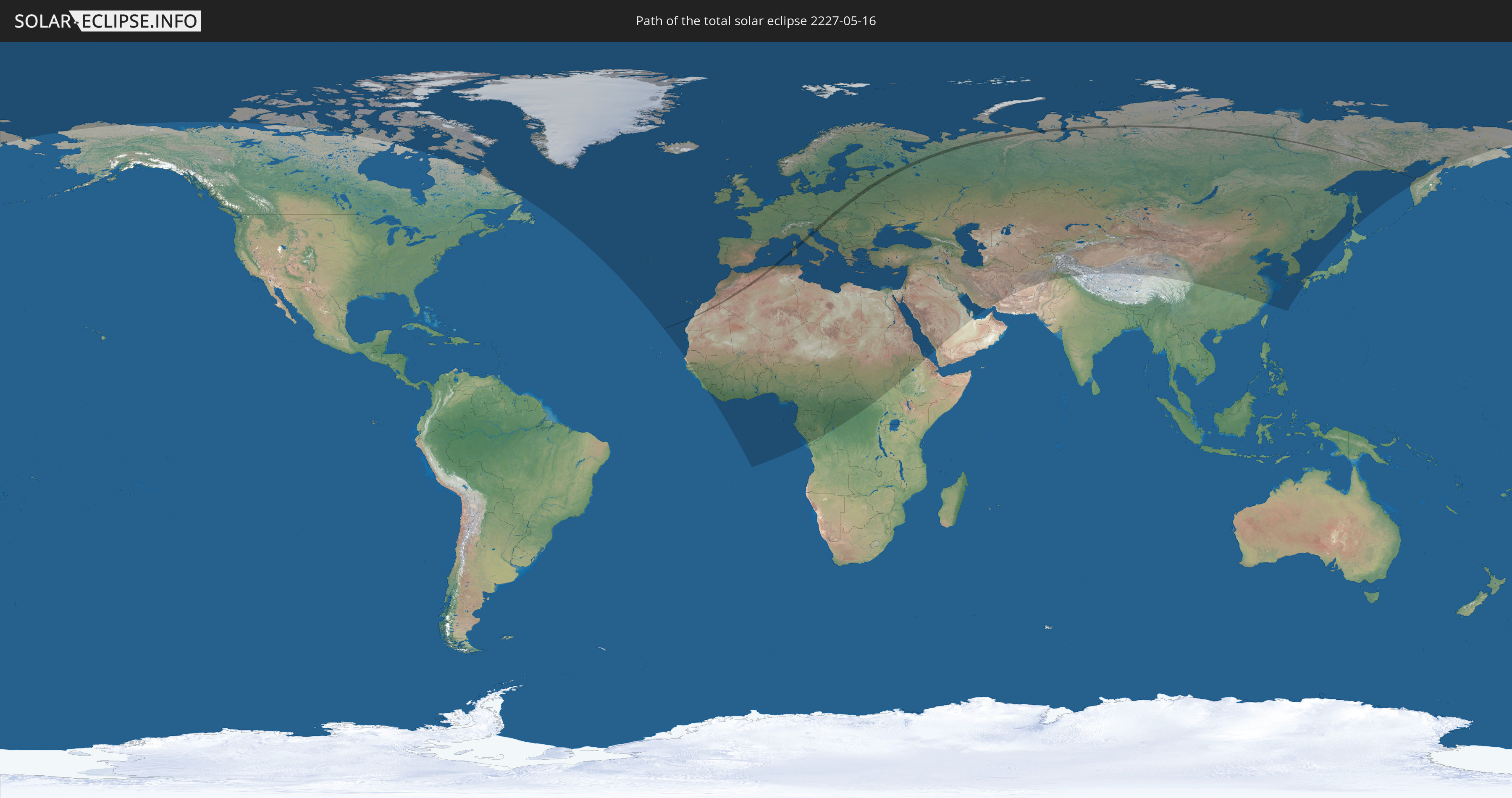
Die Sonnenfinsternis am 16.05.2227 kann man in 117 Ländern als partielle Sonnenfinsternis beobachten.
Der Finsternispfad verläuft durch 16 Länder. Nur in diesen Ländern ist sie als totale Sonnenfinsternis zu sehen.
In den folgenden Ländern ist die Sonnenfinsternis total zu sehen
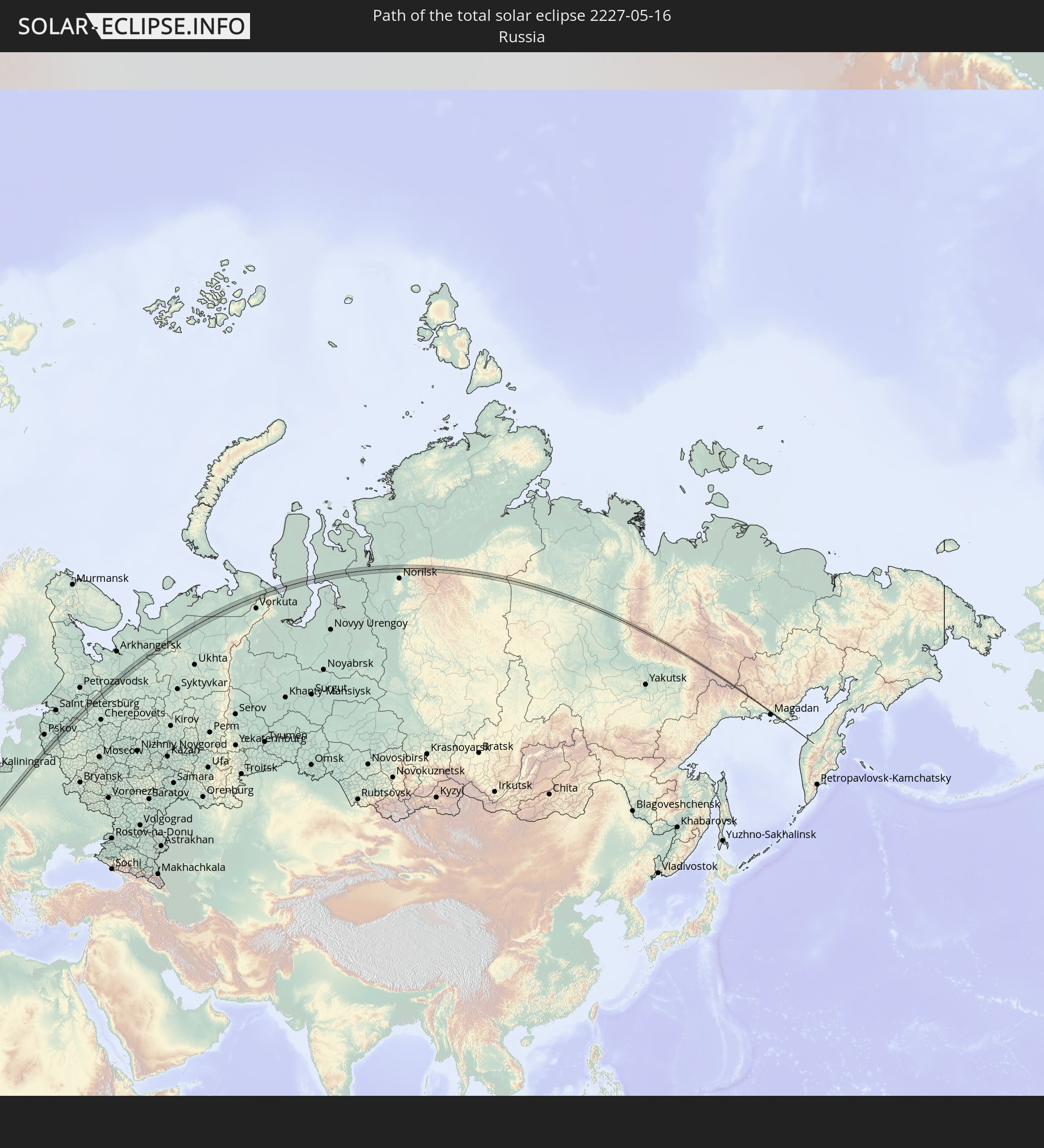 Russland
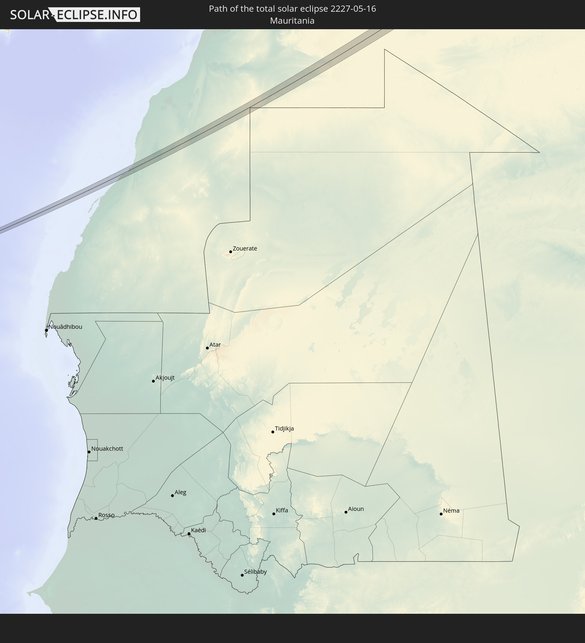 Mauretanien
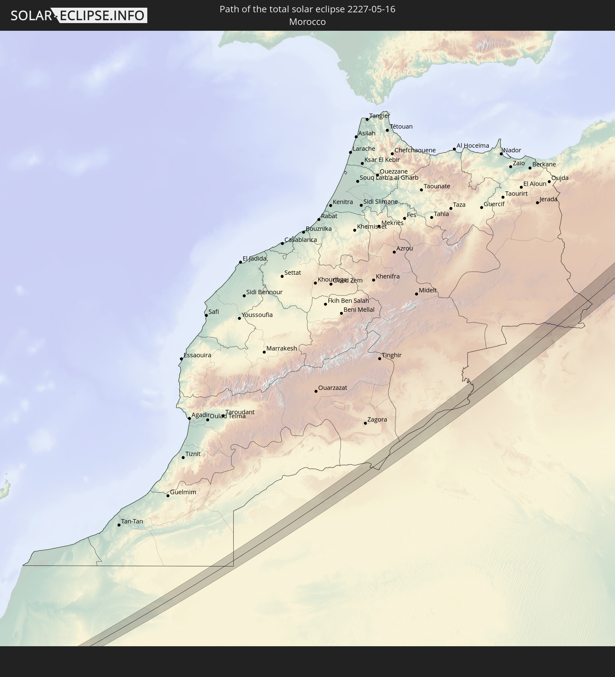 Marokko
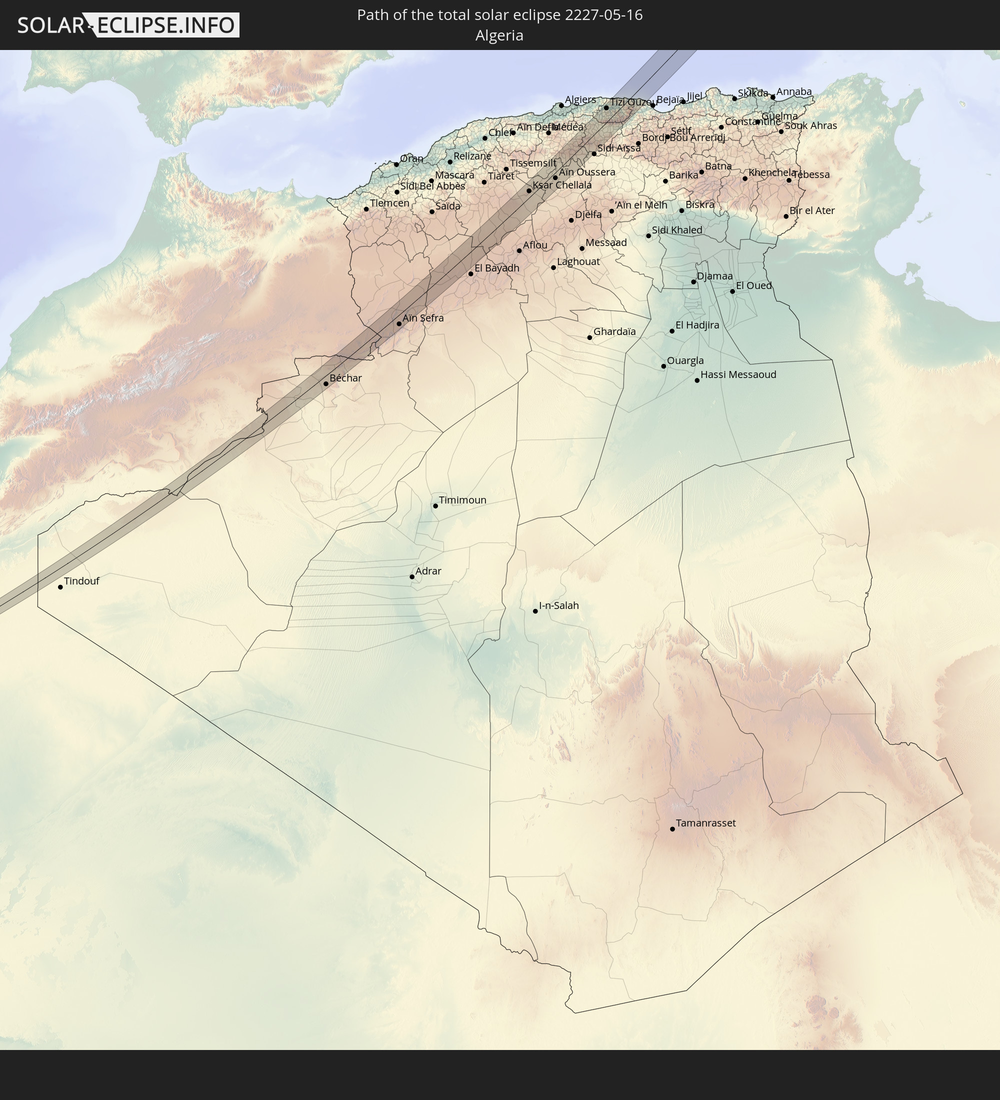 Algerien
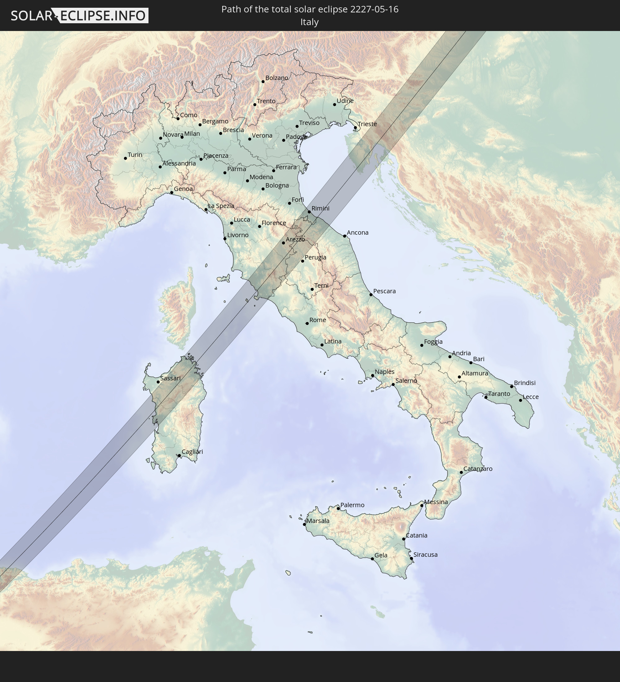 Italien
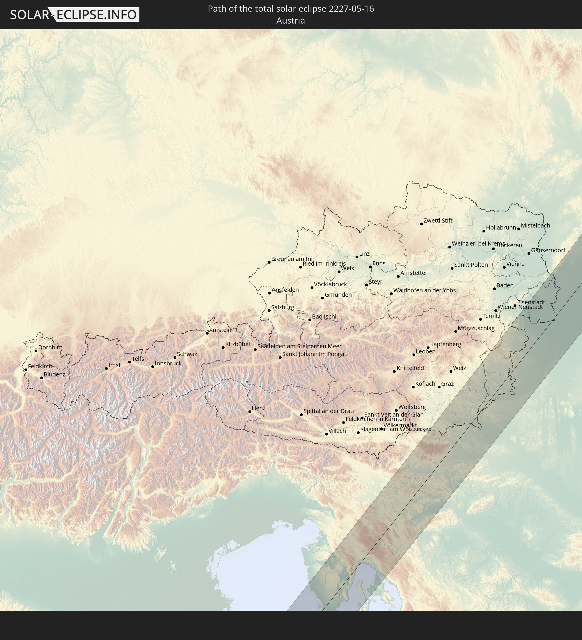 Österreich
 Tschechien
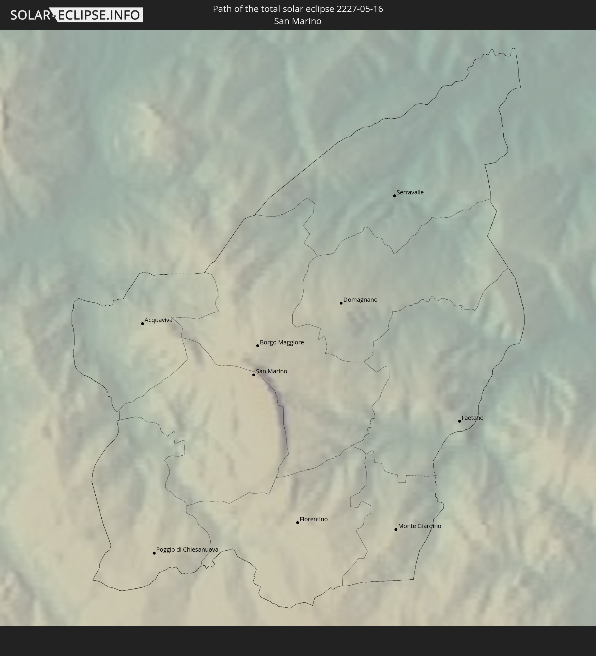 San Marino
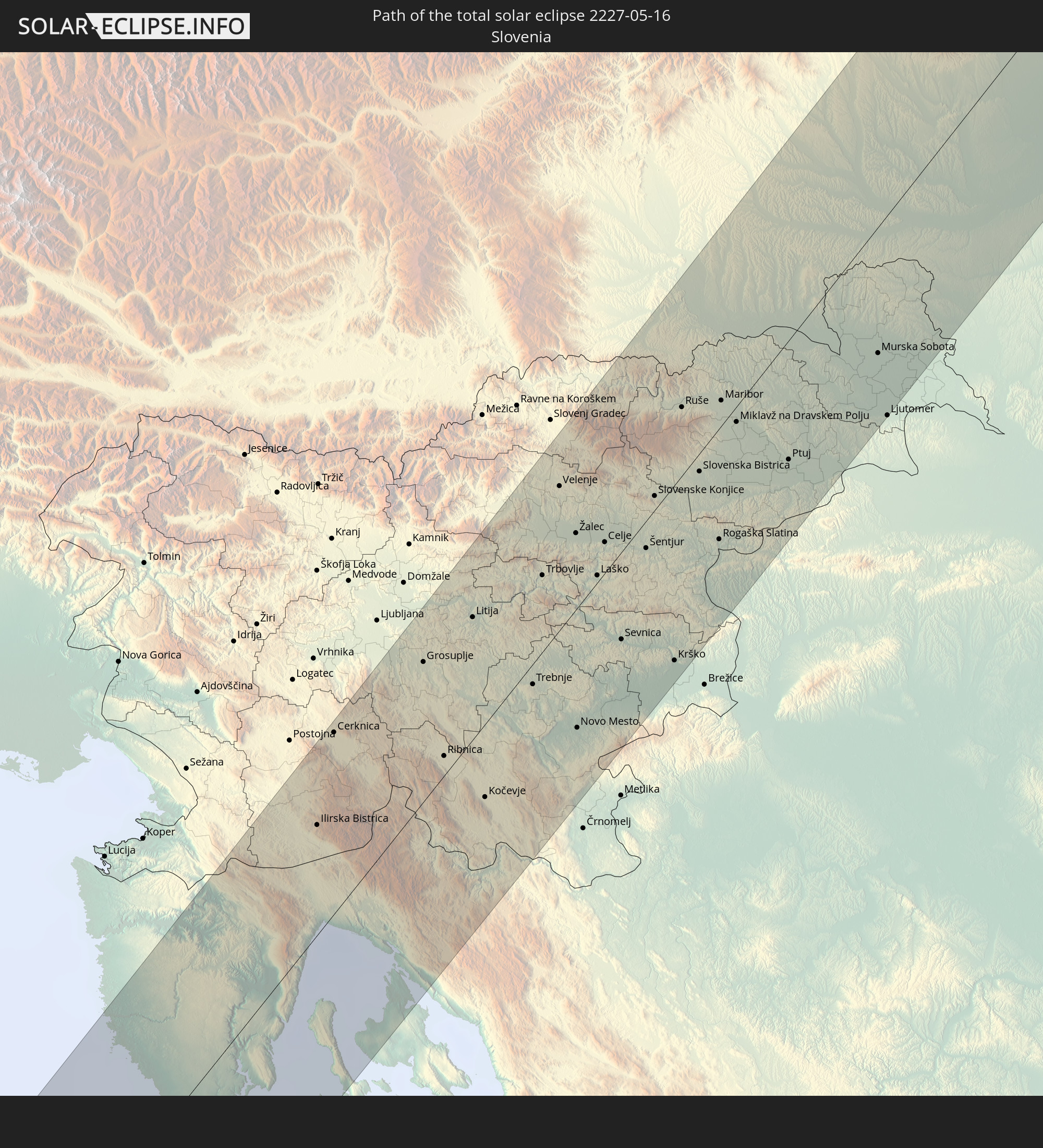 Slowenien
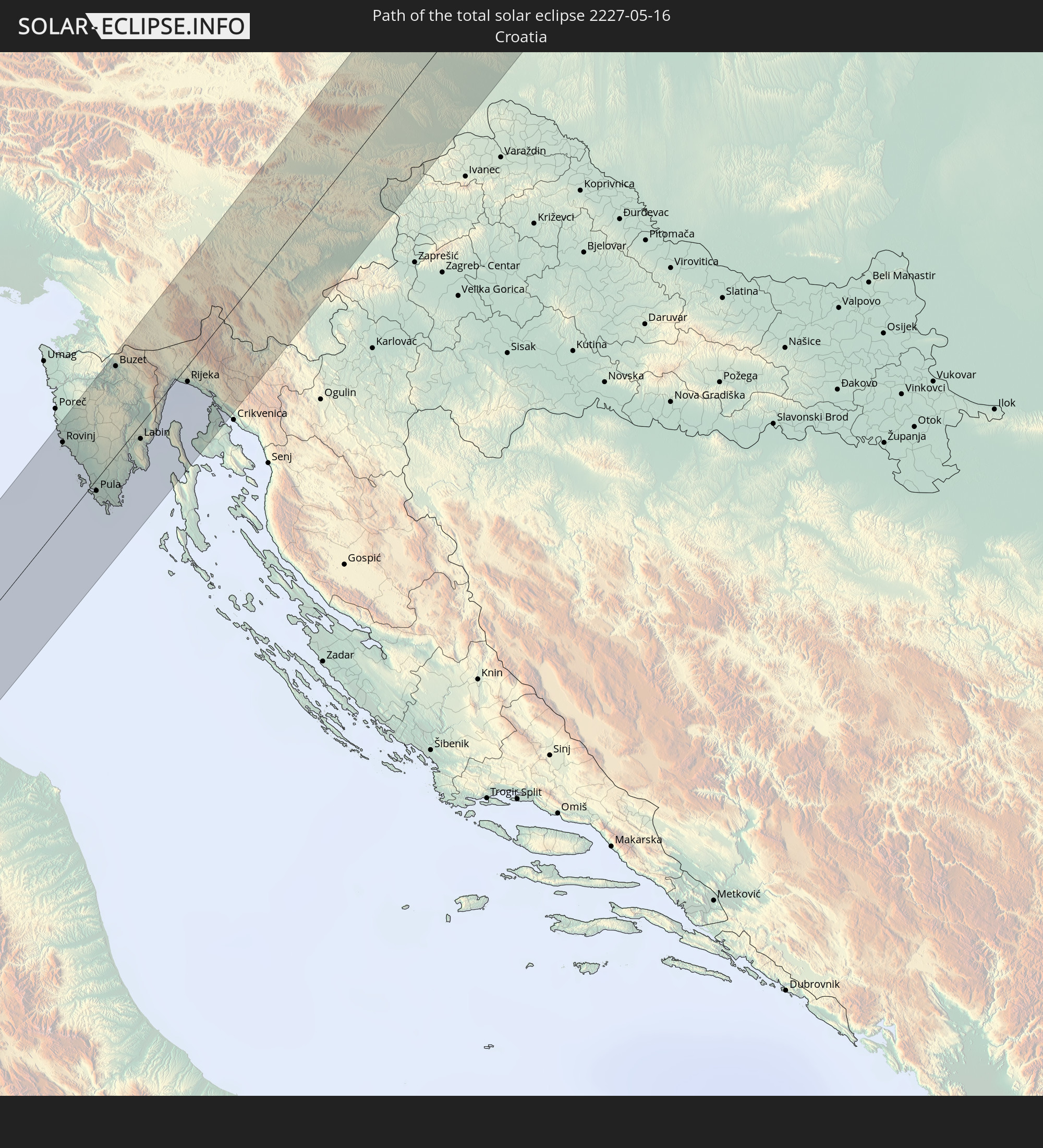 Kroatien
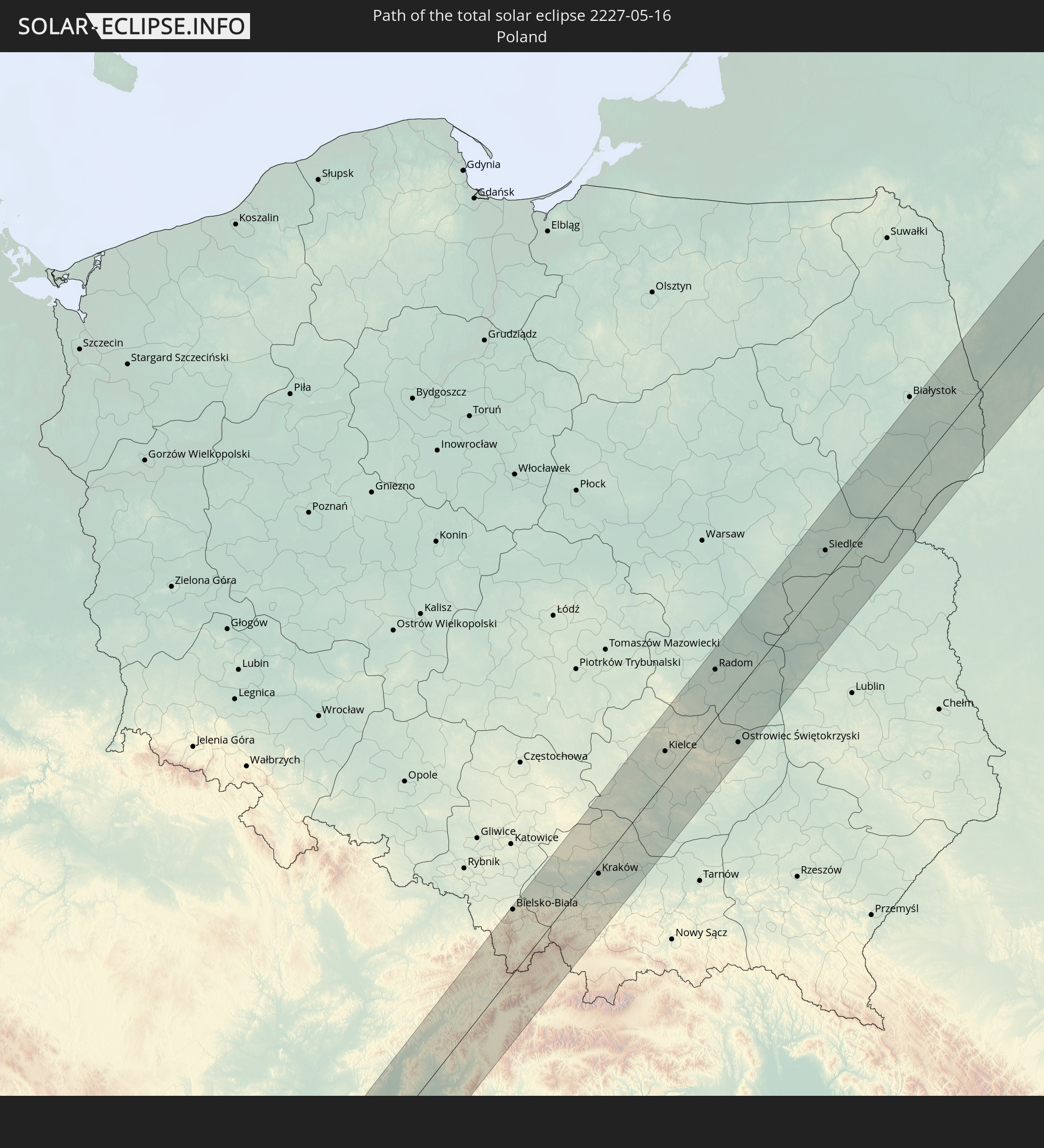 Polen
Polen
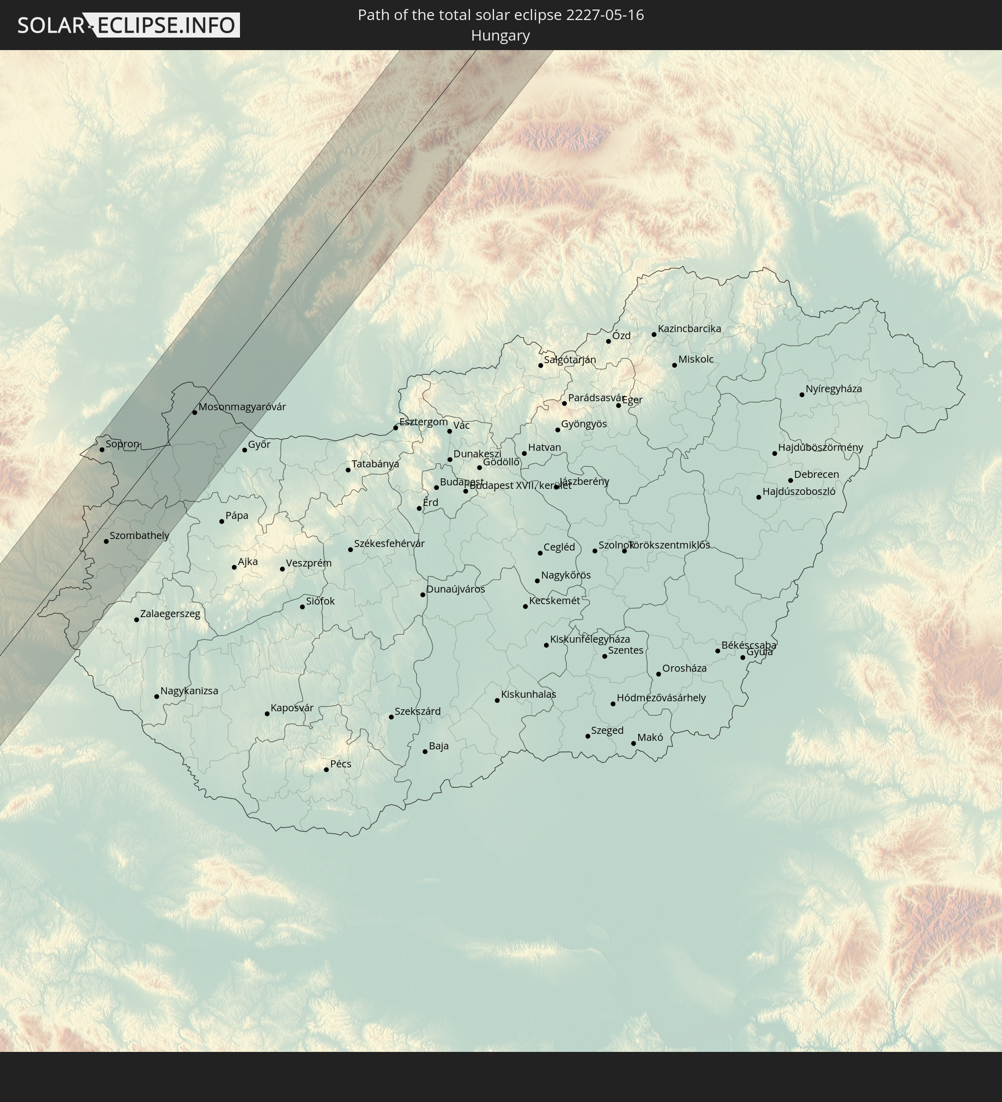 Ungarn
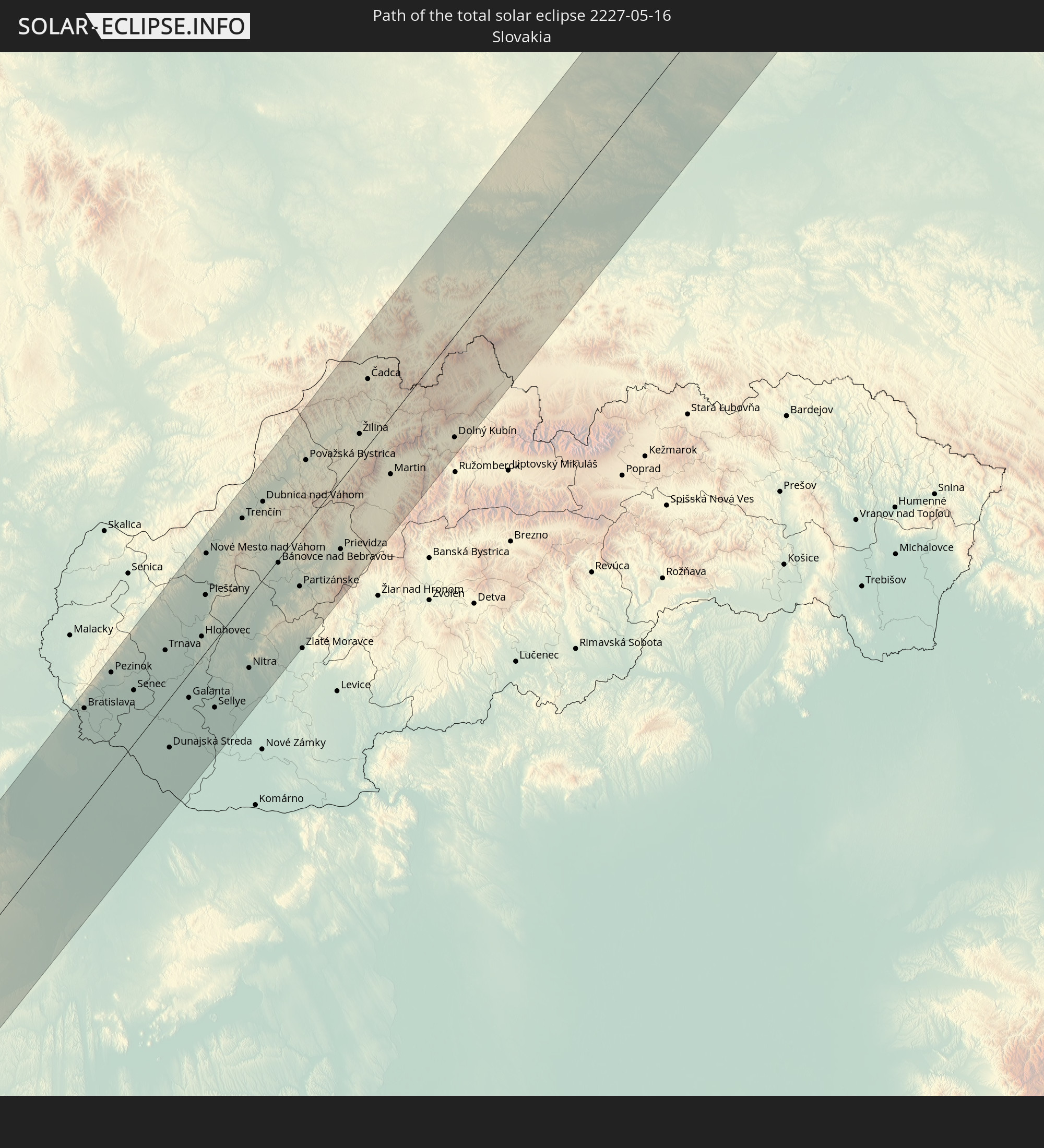 Slowakei
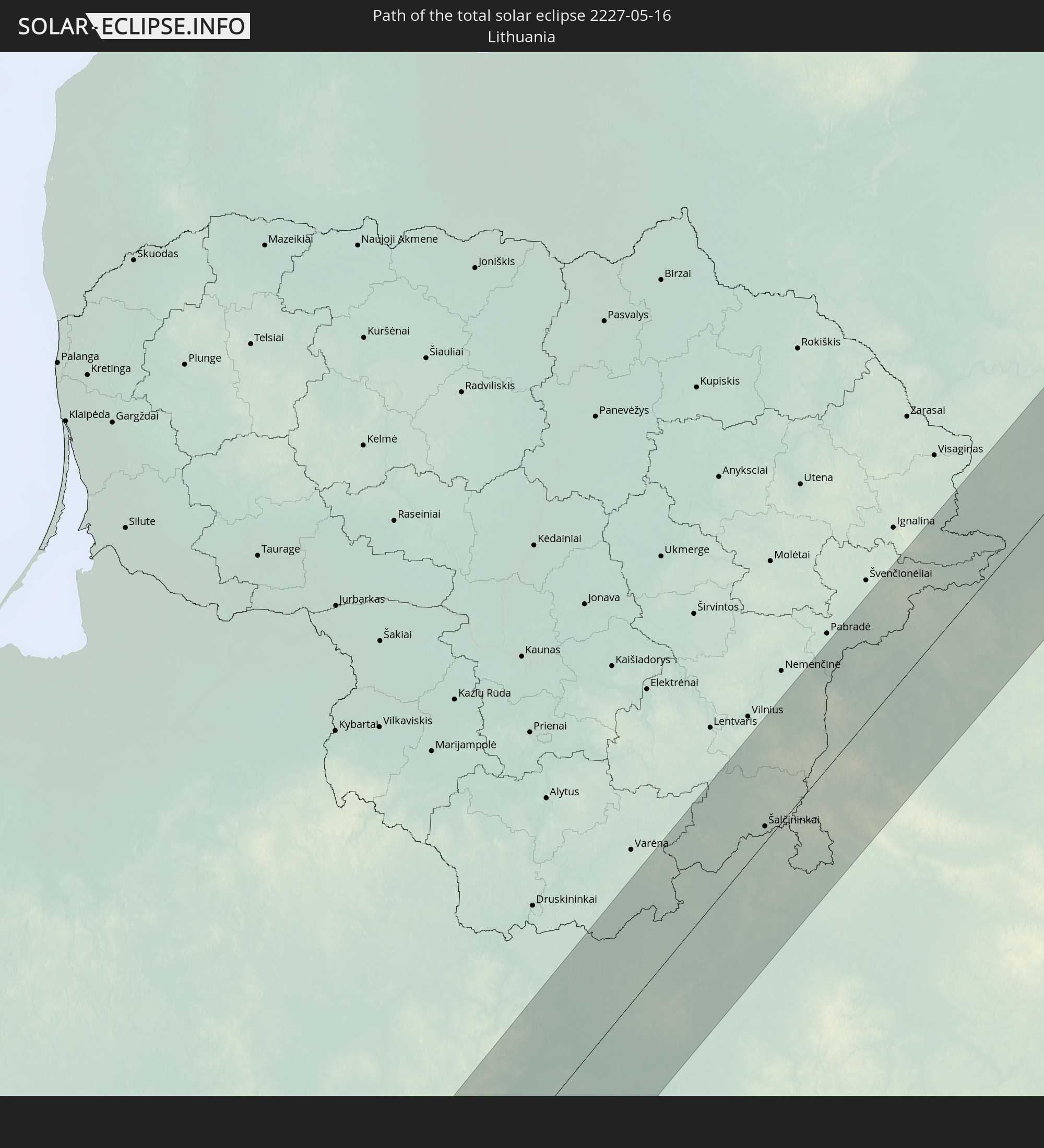 Litauen
 Lettland
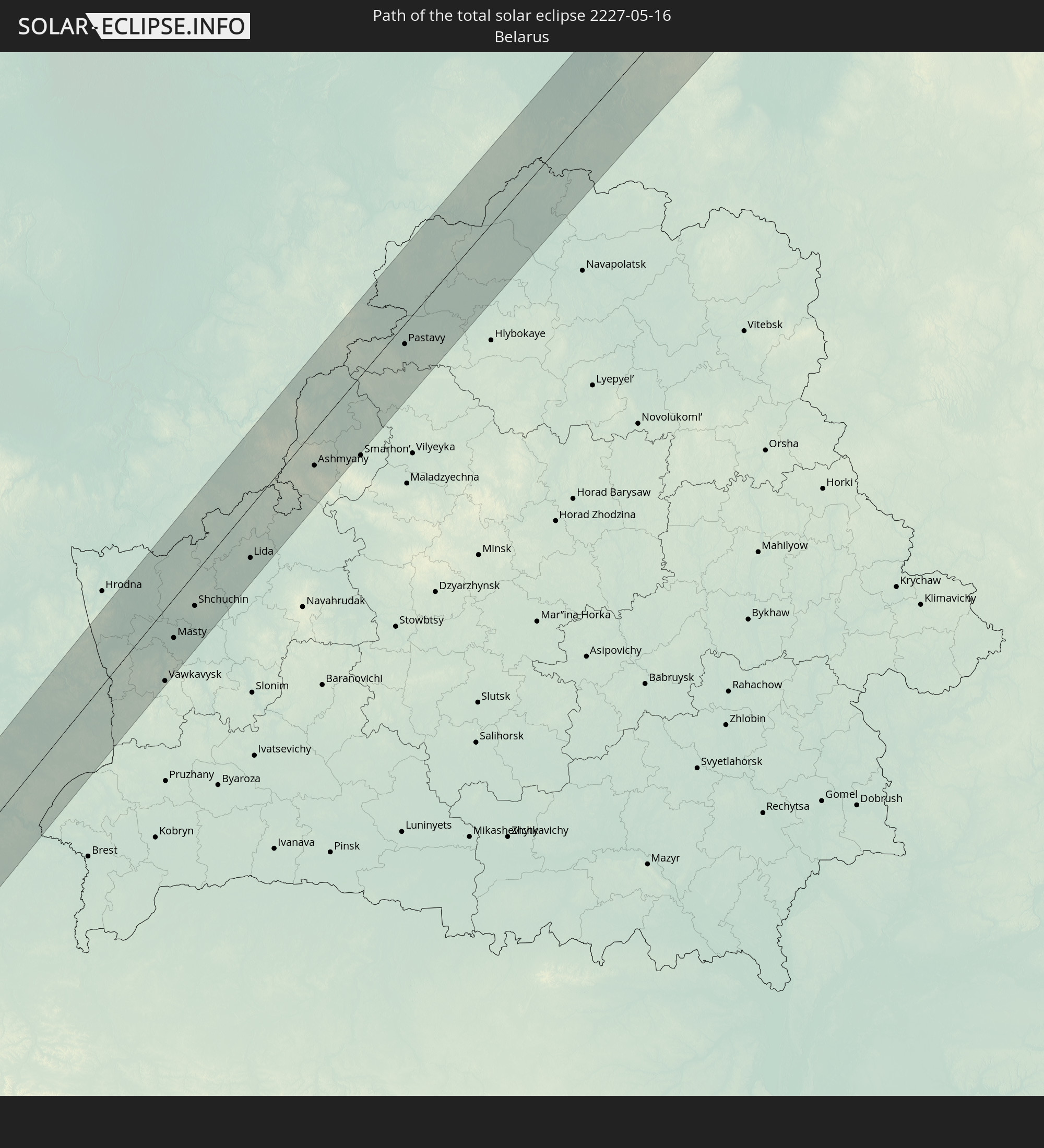 Weißrussland
In den folgenden Ländern ist die Sonnenfinsternis partiell zu sehen
 Russland
 Vereinigte Staaten
 Kanada
 Grönland
 Portugal
 Island
 Spanien
 Senegal
 Mauretanien
 Gambia
 Guinea-Bissau
 Guinea
 Sierra Leone
 Marokko
 Mali
Mali
 Liberia
 Irland
 Spitzbergen
 Algerien
 Vereinigtes Königreich
 Elfenbeinküste
 Färöer
 Burkina Faso
 Gibraltar
 Frankreich
 Isle of Man
 Ghana
Ghana
 Guernsey
 Jersey
 Togo
Togo
 Niger
Niger
 Benin
Benin
 Andorra
 Belgien
 Nigeria
 Niederlande
 Norwegen
 Äquatorialguinea
 Luxemburg
 Deutschland
 Schweiz
 São Tomé und Príncipe
 Italien
 Monaco
 Tunesien
 Dänemark
 Kamerun
 Gabun
Gabun
 Libyen
 Liechtenstein
 Österreich
 Schweden
 Republik Kongo
 Angola
 Tschechien
 Demokratische Republik Kongo
 San Marino
 Vatikanstadt
 Slowenien
 Tschad
 Kroatien
 Polen
Polen
 Malta
Malta
 Zentralafrikanische Republik
 Bosnien und Herzegowina
 Ungarn
 Slowakei
 Montenegro
 Serbien
 Albanien
 Åland Islands
 Griechenland
 Rumänien
 Mazedonien
 Finnland
 Litauen
 Lettland
 Estland
 Sudan
Sudan
 Ukraine
 Bulgarien
 Weißrussland
 Ägypten
 Türkei
 Moldawien
 Republik Zypern
 Äthiopien
 Staat Palästina
 Israel
 Saudi-Arabien
 Jordanien
 Libanon
 Syrien
 Eritrea
 Irak
Irak
 Georgien
 Jemen
Jemen
 Armenien
 Iran
Iran
 Aserbaidschan
 Kasachstan
 Kuwait
 Bahrain
 Katar
Katar
 Vereinigte Arabische Emirate
 Turkmenistan
 Usbekistan
 Afghanistan
 Pakistan
 Tadschikistan
 Indien
 Kirgisistan
 Volksrepublik China
 Mongolei
 Japan
Japan
 Nordkorea
 Südkorea
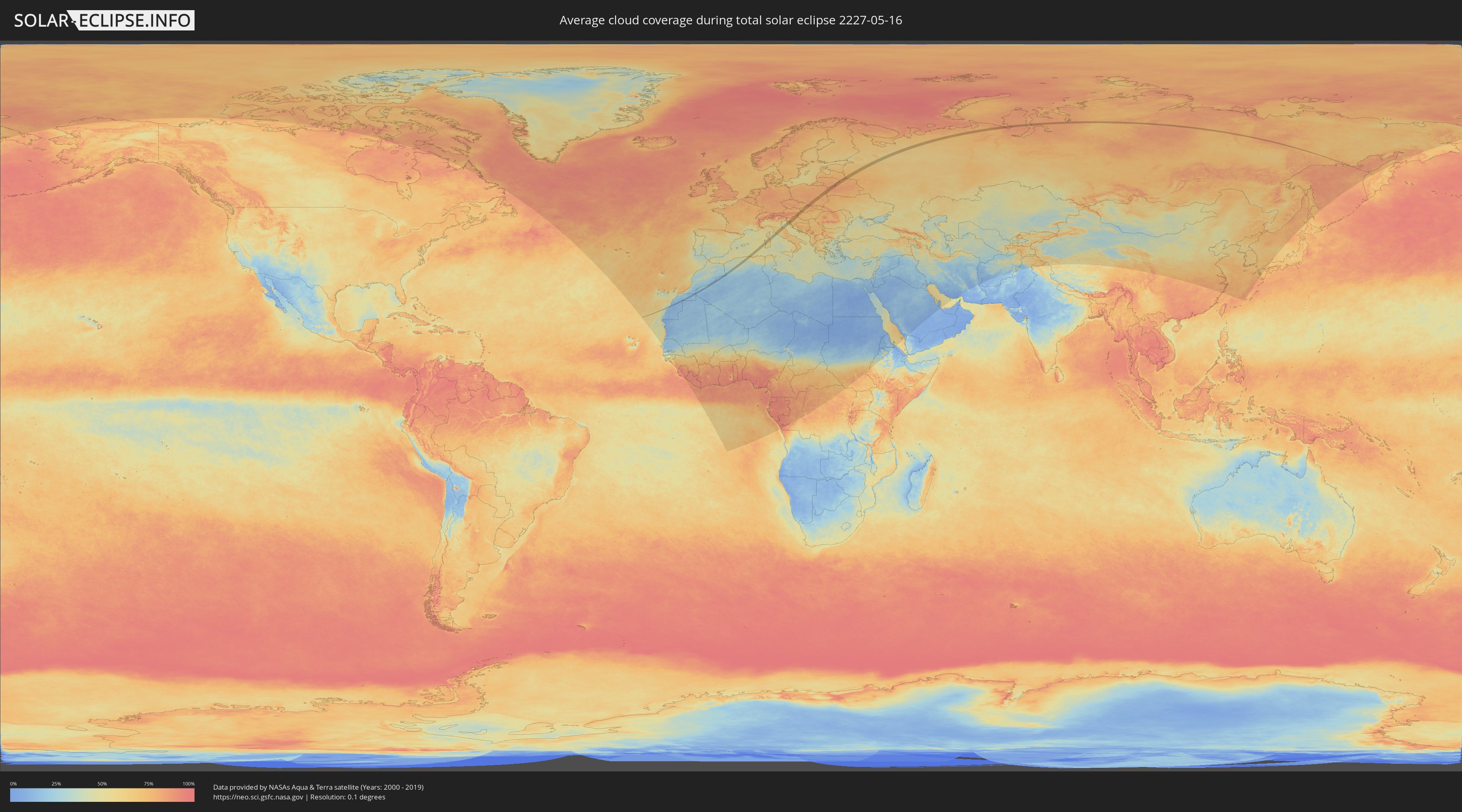
Wie wird das Wetter während der totalen Sonnenfinsternis am 16.05.2227?
Wo ist der beste Ort, um die totale Sonnenfinsternis vom 16.05.2227 zu beobachten?
Die folgenden Karten zeigen die durchschnittliche Bewölkung für den Tag, an dem die totale Sonnenfinsternis
stattfindet. Mit Hilfe der Karten lässt sich der Ort entlang des Finsternispfades eingrenzen,
der die besten Aussichen auf einen klaren wolkenfreien Himmel bietet.
Trotzdem muss man immer lokale Gegenenheiten beachten und sollte sich genau über das Wetter an seinem
gewählten Beobachtungsort informieren.
Die Daten stammen von den beiden NASA-Satelliten
AQUA und TERRA
und wurden über einen Zeitraum von 19 Jahren (2000 - 2019) gemittelt.

Detaillierte Länderkarten
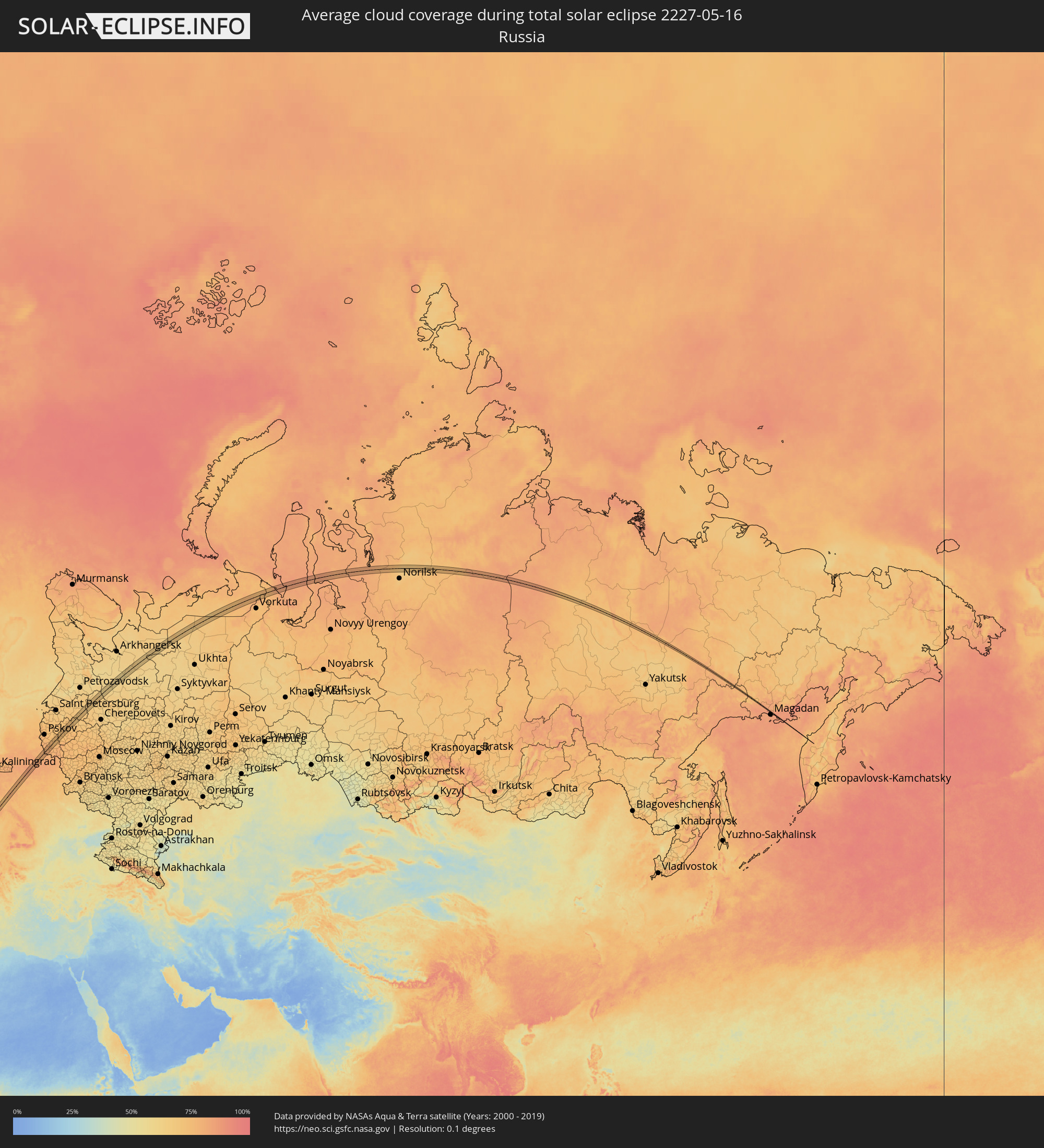 Russland
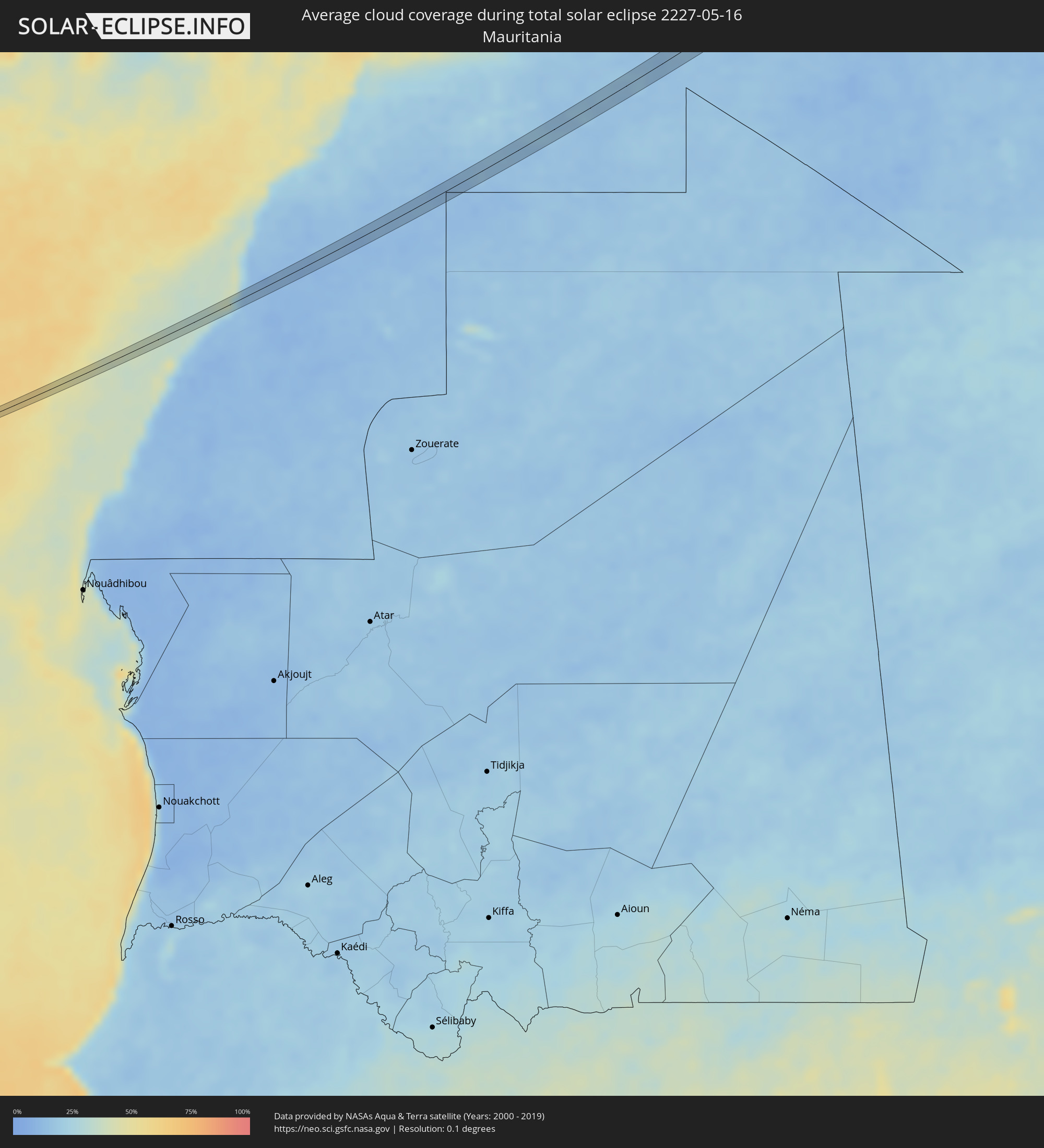 Mauretanien
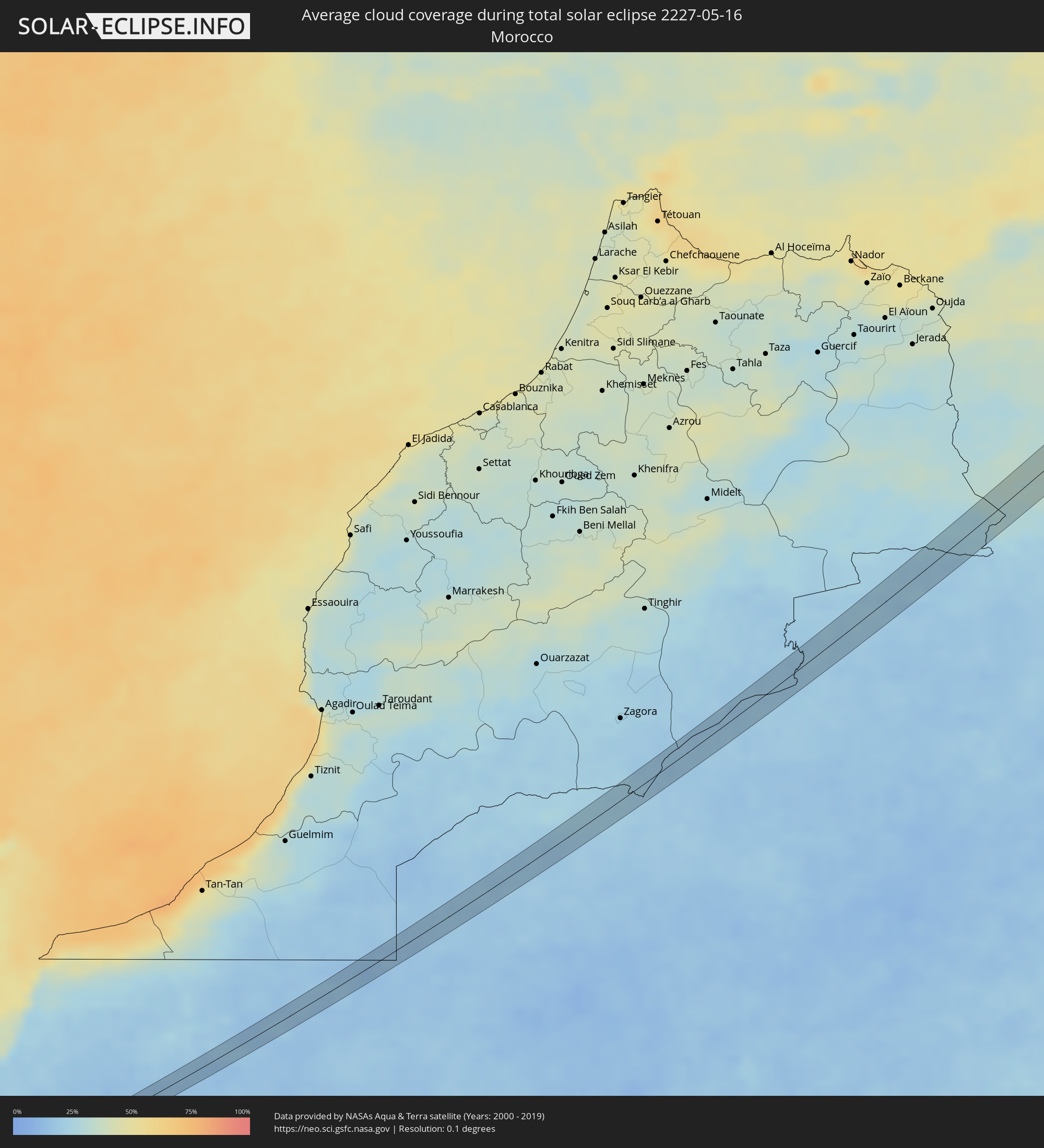 Marokko
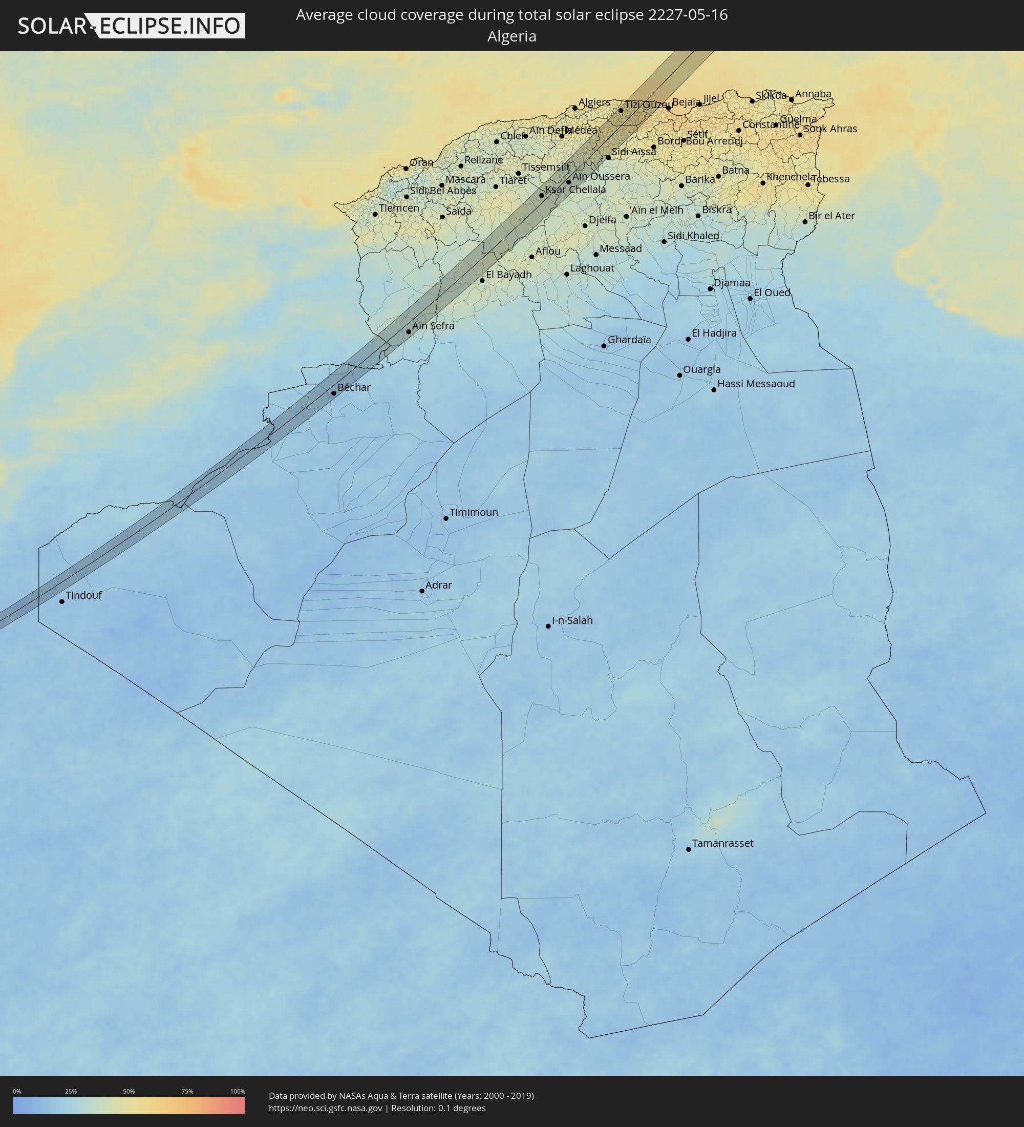 Algerien
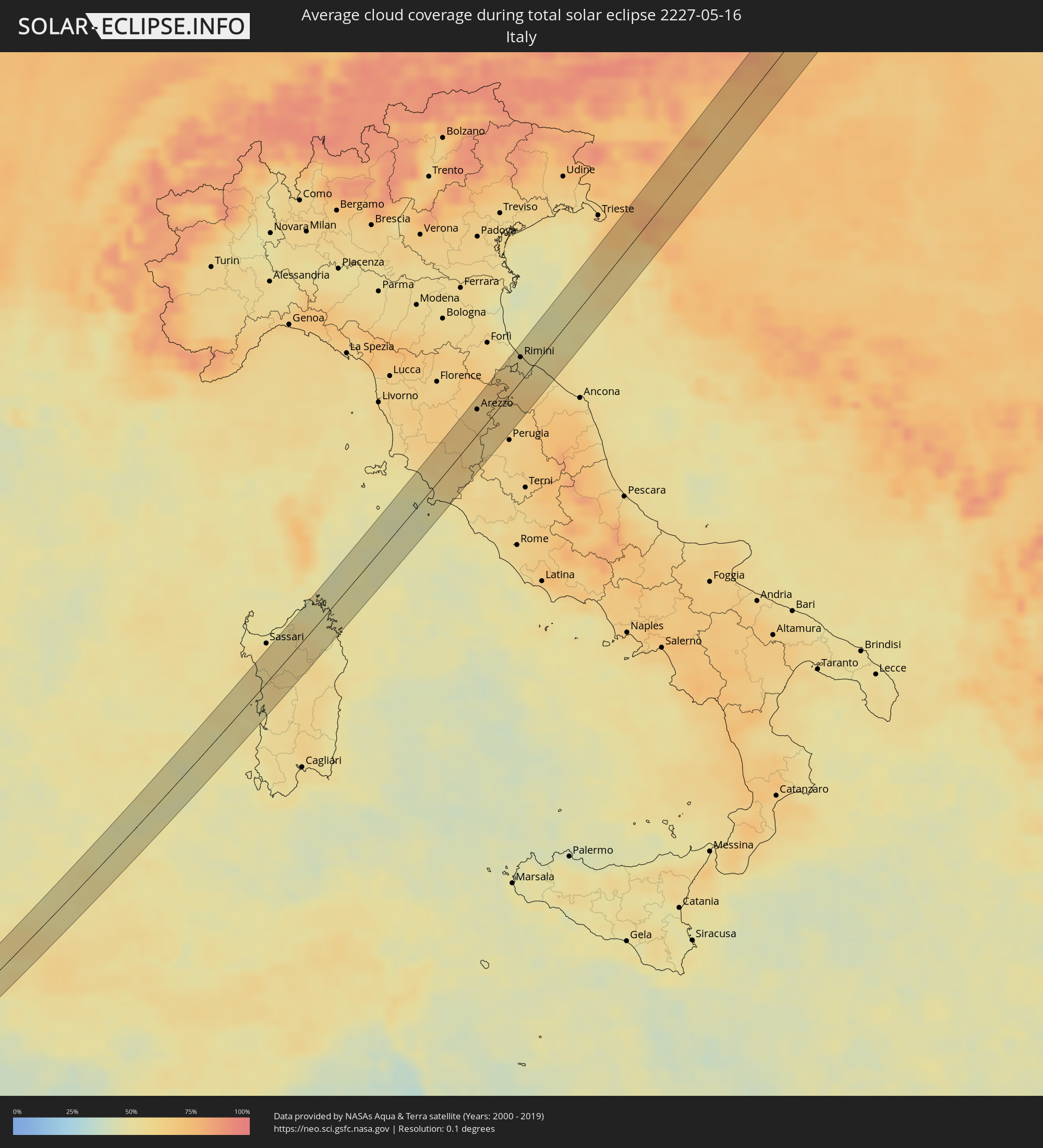 Italien
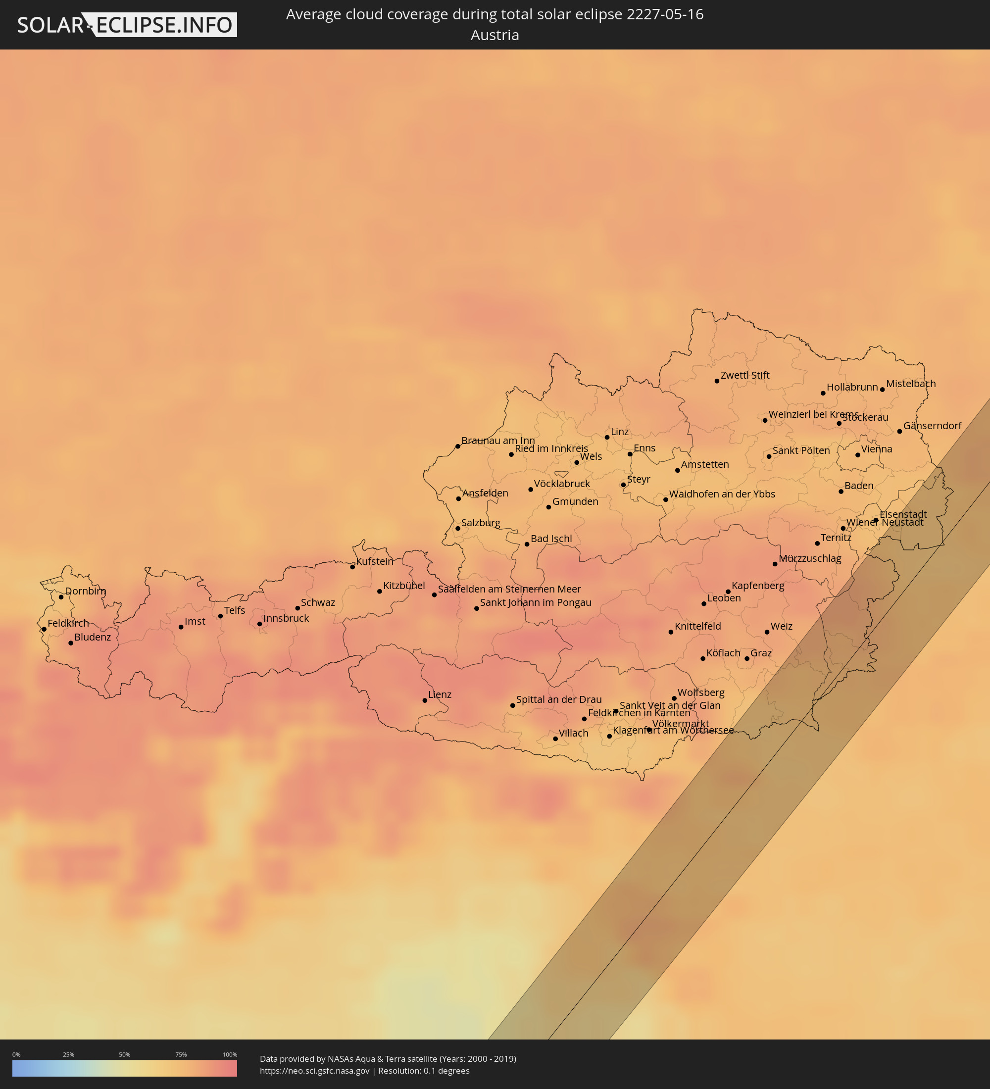 Österreich
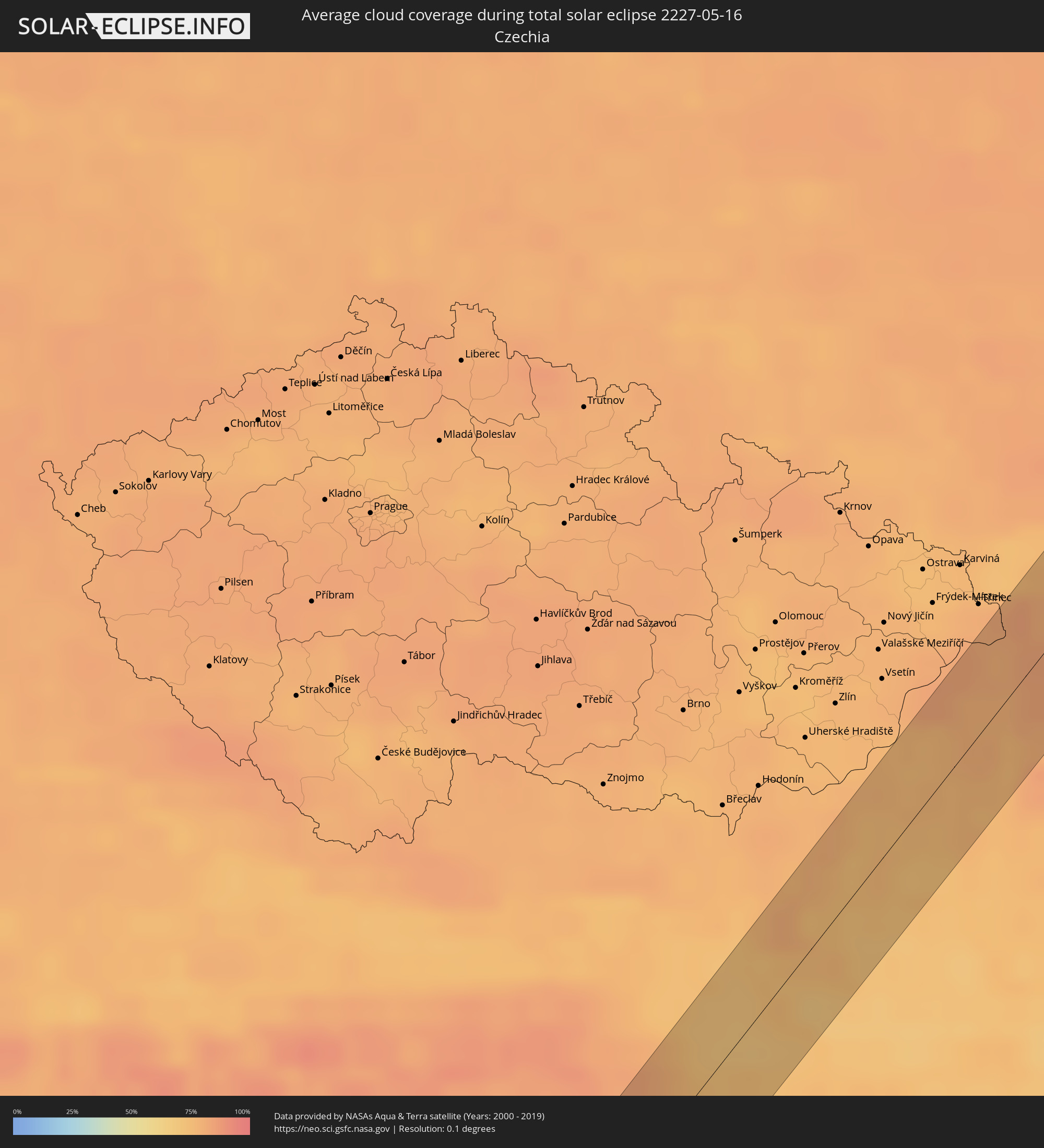 Tschechien
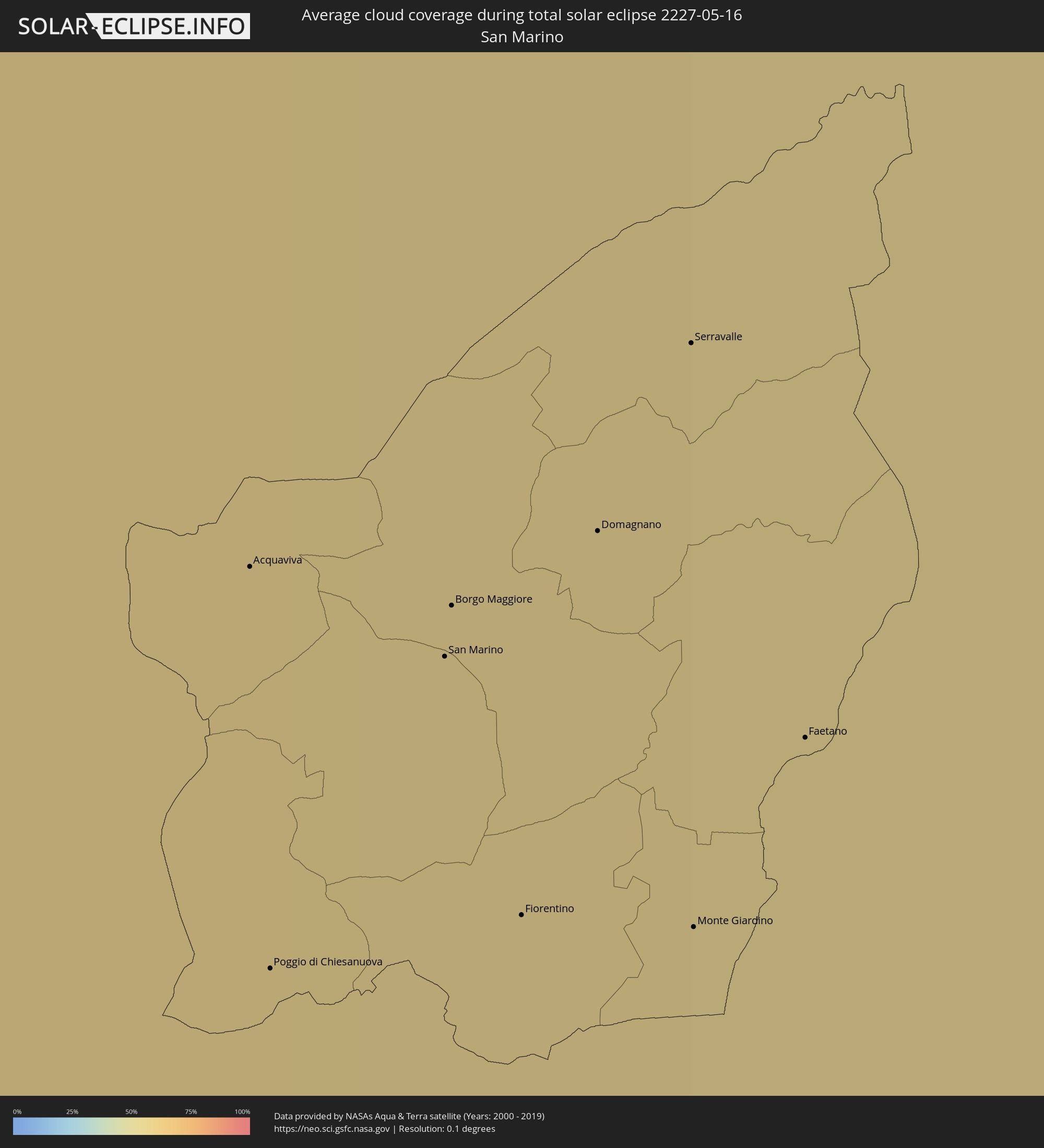 San Marino
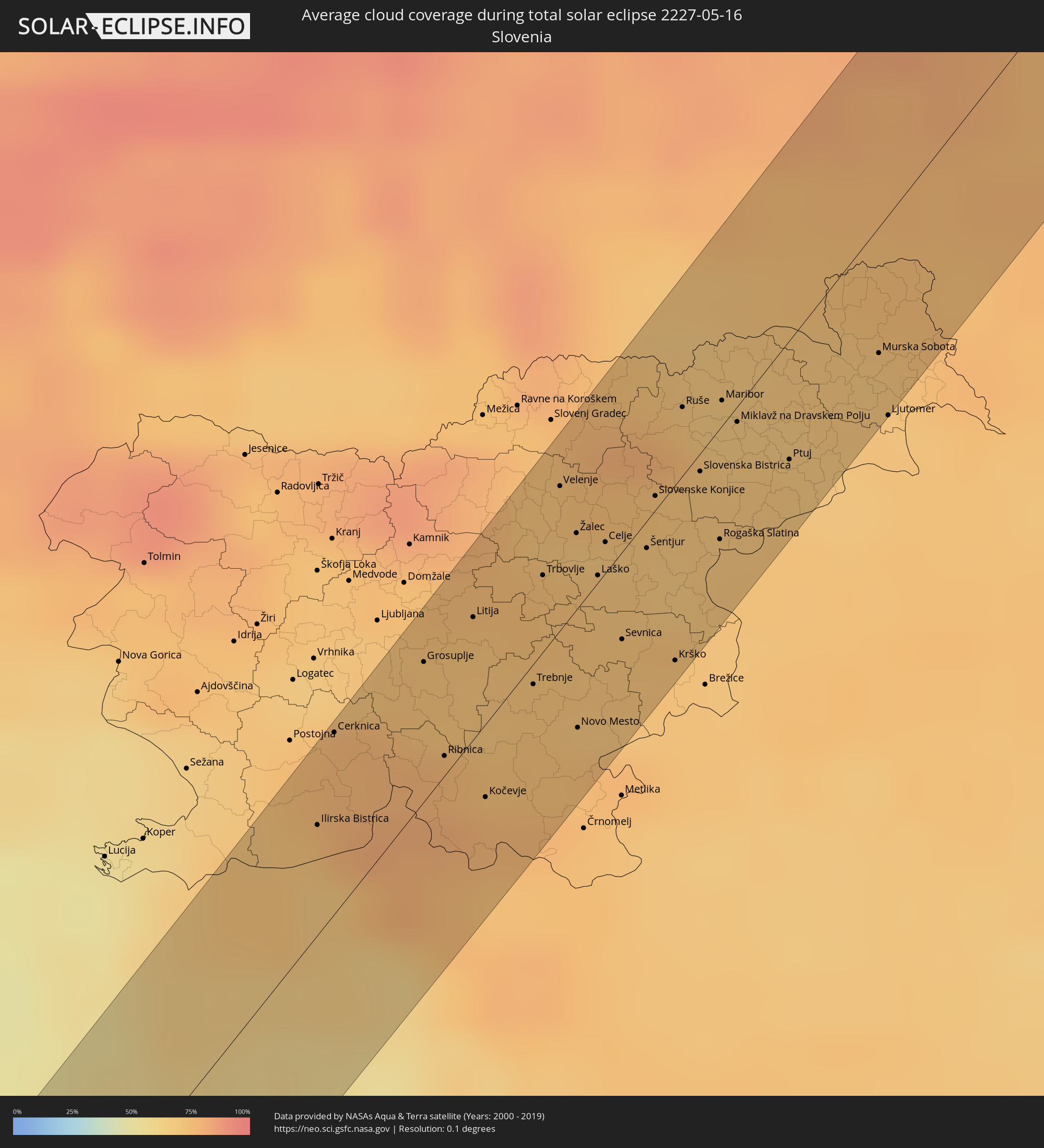 Slowenien
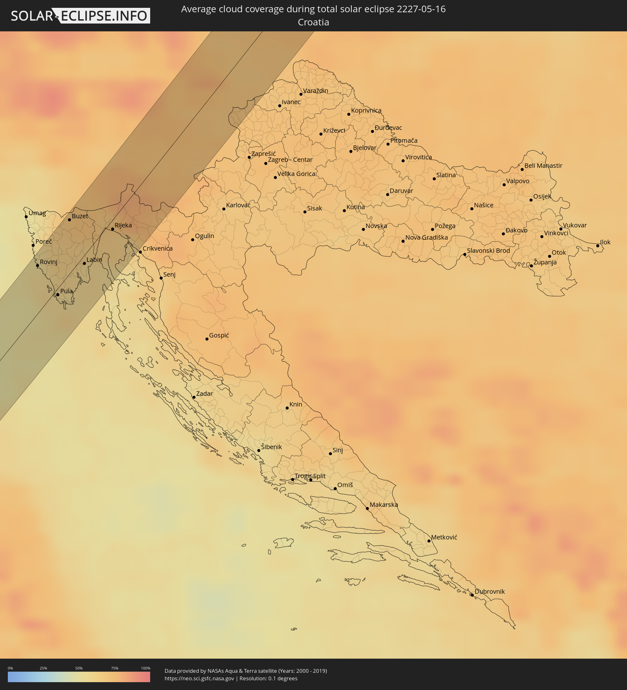 Kroatien
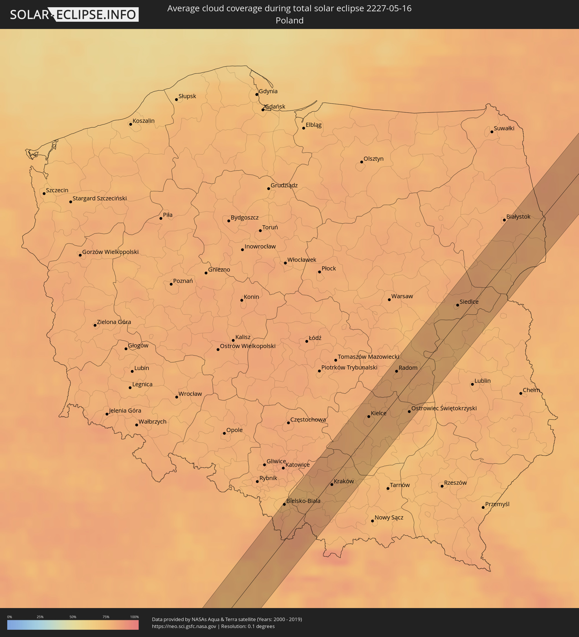 Polen
Polen
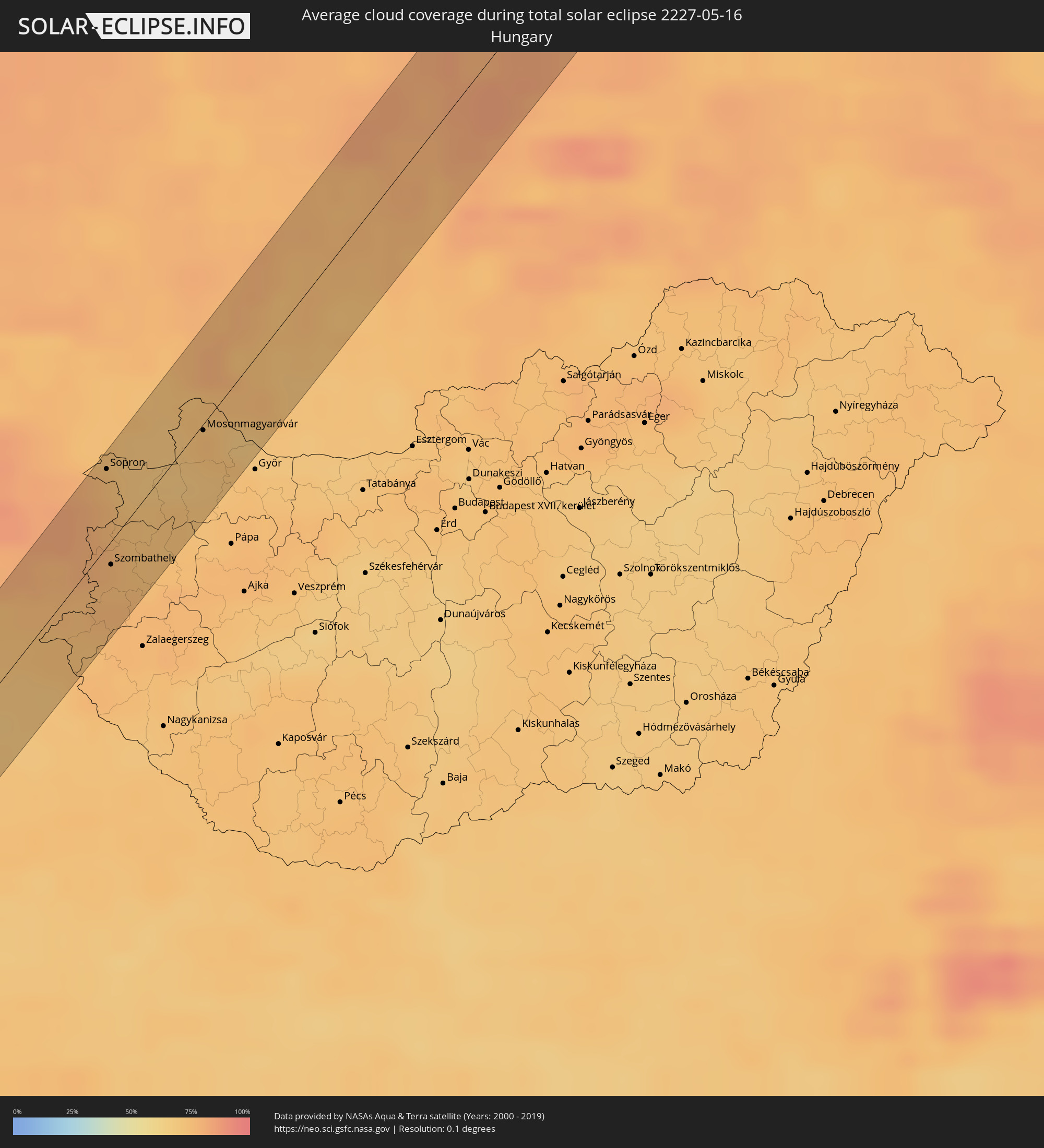 Ungarn
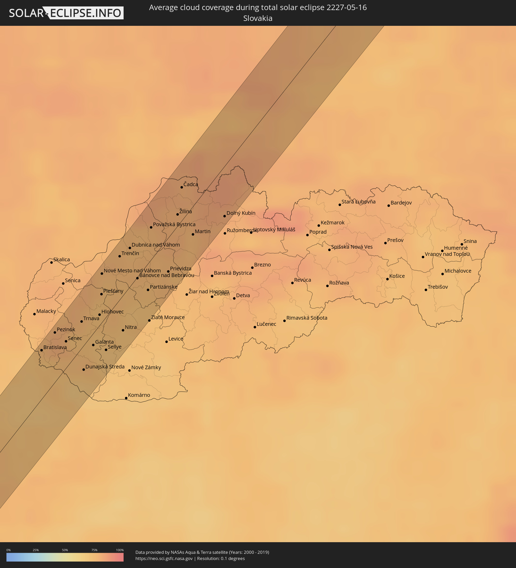 Slowakei
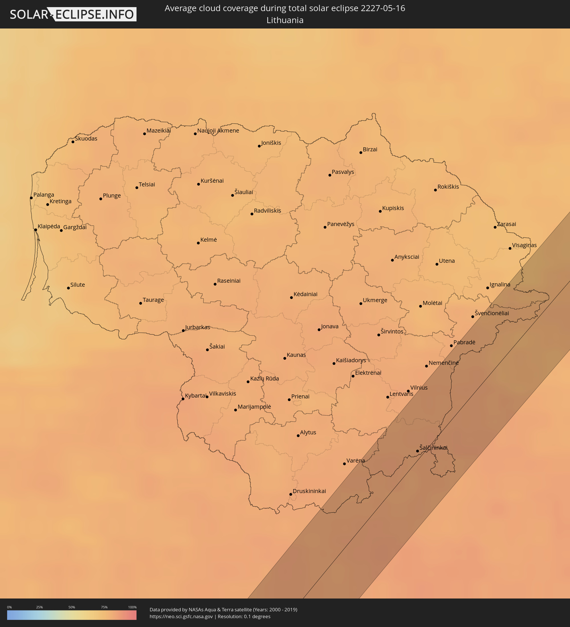 Litauen
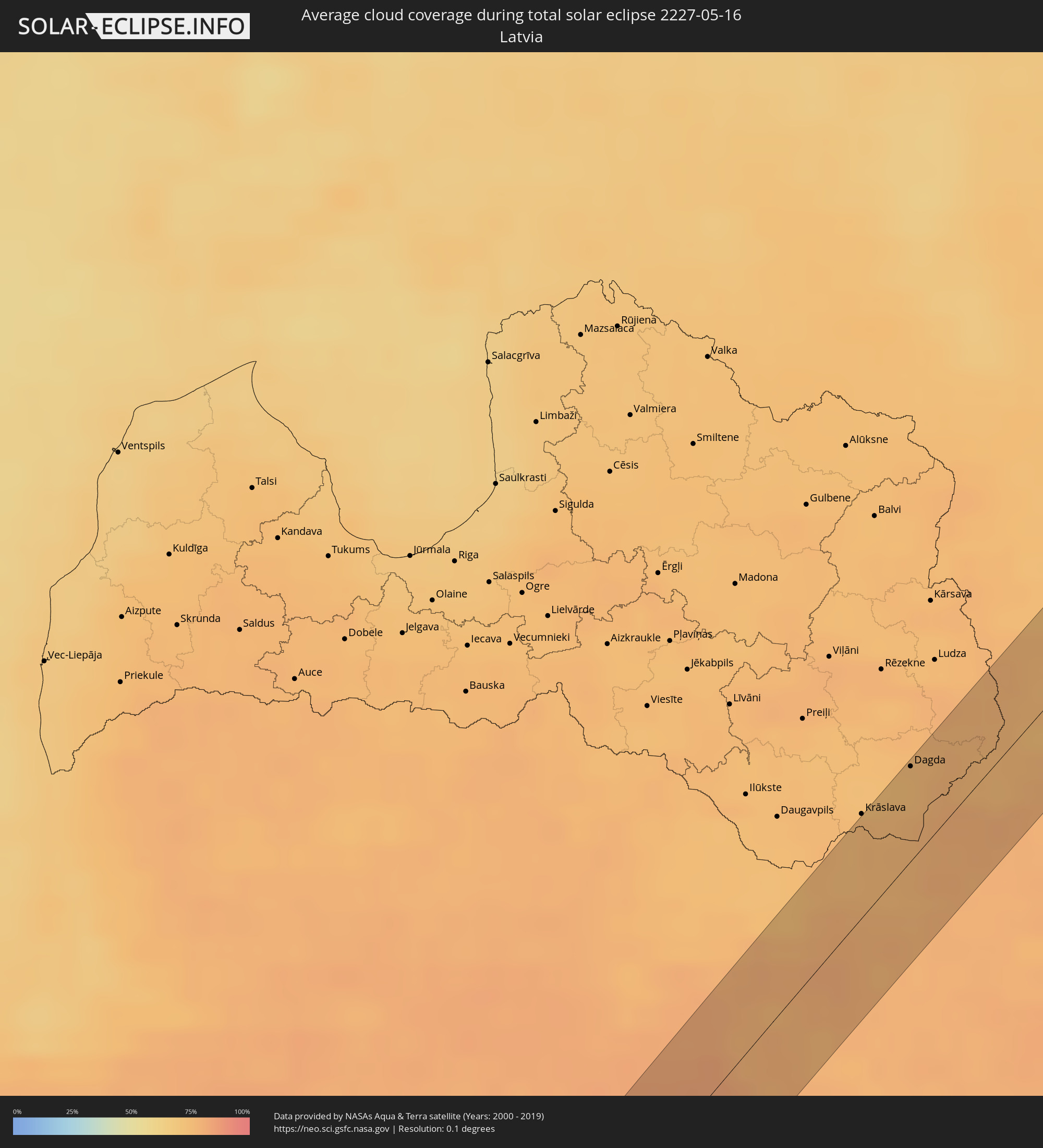 Lettland
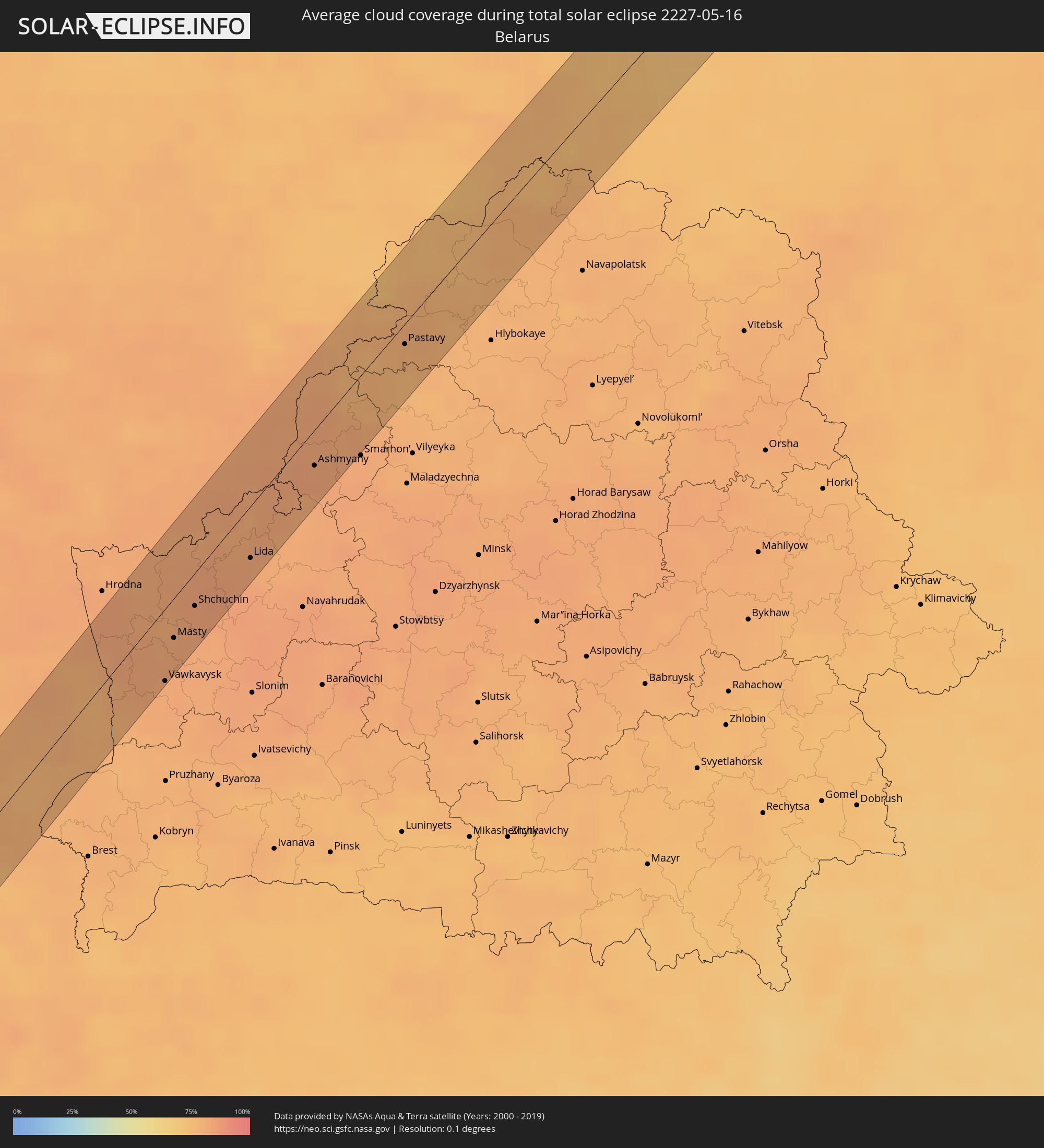 Weißrussland
Orte im Finsternispfad
Die nachfolgene Tabelle zeigt Städte und Orte mit mehr als 5.000 Einwohnern, die sich im Finsternispfad befinden. Städte mit mehr als 100.000 Einwohnern sind dick gekennzeichnet. Mit einem Klick auf den Ort öffnet sich eine Detailkarte die die Lage des jeweiligen Ortes zusammen mit dem Verlauf der zentralen Finsternis präsentiert.
| Ort | Typ | Dauer der Verfinsterung | Ortszeit bei maximaler Verfinsterung | Entfernung zur Zentrallinie | Ø Bewölkung |
|
Béchar, Béchar
|
total | - | 08:03:55 UTC+01:00 | 27 km | 16% |
|
Aïn Sefra, Naama
|
total | - | 08:06:05 UTC+01:00 | 28 km | 32% |
|
Ksar Chellala, Tiaret
|
total | - | 08:11:05 UTC+01:00 | 17 km | 40% |
|
Aïn Oussera, Djelfa
|
total | - | 08:11:41 UTC+01:00 | 22 km | 38% |
|
Birine, Djelfa
|
total | - | 08:12:07 UTC+01:00 | 20 km | 37% |
|
Aïn Bessem, Bouira
|
total | - | 08:13:28 UTC+01:00 | 10 km | 48% |
|
Sour el Ghozlane, Bouira
|
total | - | 08:13:12 UTC+01:00 | 3 km | 45% |
|
Bouïra, Bouira
|
total | - | 08:13:41 UTC+01:00 | 11 km | 47% |
|
Boghni, Tizi Ouzou
|
total | - | 08:14:01 UTC+01:00 | 13 km | 53% |
|
Tizi Ouzou, Tizi Ouzou
|
total | - | 08:14:21 UTC+01:00 | 31 km | 51% |
|
L’Arbaa Naït Irathen, Tizi Ouzou
|
total | - | 08:14:15 UTC+01:00 | 28 km | 55% |
|
Mekla, Tizi Ouzou
|
total | - | 08:14:22 UTC+01:00 | 27 km | 52% |
|
Timizart, Tizi Ouzou
|
total | - | 08:14:36 UTC+01:00 | 21 km | 52% |
|
’Aïn el Hammam, Tizi Ouzou
|
total | - | 08:14:10 UTC+01:00 | 31 km | 56% |
|
Freha, Tizi Ouzou
|
total | - | 08:14:31 UTC+01:00 | 19 km | 52% |
|
Bosa, Sardinia
|
total | - | 08:23:00 UTC+01:00 | 10 km | 53% |
|
Ittiri, Sardinia
|
total | - | 08:23:36 UTC+01:00 | 37 km | 57% |
|
Oristano, Sardinia
|
total | - | 08:22:16 UTC+01:00 | 35 km | 52% |
|
Macomer, Sardinia
|
total | - | 08:23:03 UTC+01:00 | 24 km | 58% |
|
Tempio Pausania, Sardinia
|
total | - | 08:24:28 UTC+01:00 | 30 km | 58% |
|
La Maddalena, Sardinia
|
total | - | 08:25:14 UTC+01:00 | 17 km | 48% |
|
Olbia, Sardinia
|
total | - | 08:24:43 UTC+01:00 | 17 km | 50% |
|
Grosseto, Tuscany
|
total | - | 08:29:12 UTC+01:00 | 33 km | 58% |
|
Monte Argentario, Tuscany
|
total | - | 08:28:33 UTC+01:00 | 11 km | 48% |
|
Arezzo, Tuscany
|
total | - | 08:31:02 UTC+01:00 | 22 km | 62% |
|
Città di Castello, Umbria
|
total | - | 08:31:15 UTC+01:00 | 28 km | 62% |
|
Umbertide, Umbria
|
total | - | 08:31:00 UTC+01:00 | 27 km | 64% |
|
Acquaviva, Acquaviva
|
total | - | 08:32:19 UTC+01:00 | 25 km | 65% |
|
Poggio di Chiesanuova, Chiesanuova
|
total | - | 08:32:14 UTC+01:00 | 21 km | 65% |
|
San Marino, San Marino
|
total | - | 08:32:19 UTC+01:00 | 24 km | 65% |
|
Borgo Maggiore, Borgo Maggiore
|
total | - | 08:32:19 UTC+01:00 | 24 km | 65% |
|
Fiorentino, Fiorentino
|
total | - | 08:32:16 UTC+01:00 | 21 km | 60% |
|
Domagnano, Domagnano
|
total | - | 08:32:21 UTC+01:00 | 25 km | 60% |
|
Serravalle, Serravalle
|
total | - | 08:32:24 UTC+01:00 | 27 km | 58% |
|
Monte Giardino, Montegiardino
|
total | - | 08:32:17 UTC+01:00 | 20 km | 60% |
|
Faetano, Faetano
|
total | - | 08:32:20 UTC+01:00 | 23 km | 60% |
|
Rimini, Emilia-Romagna
|
total | - | 08:32:38 UTC+01:00 | 37 km | 55% |
|
Cattolica, Emilia-Romagna
|
total | - | 08:32:33 UTC+01:00 | 31 km | 55% |
|
Pesaro, The Marches
|
total | - | 08:32:33 UTC+01:00 | 30 km | 57% |
|
Rovinj, Istarska
|
total | - | 08:35:20 UTC+01:00 | 28 km | 56% |
|
Pula, Istarska
|
total | - | 08:35:03 UTC+01:00 | 24 km | 57% |
|
Pazin, Istarska
|
total | - | 08:35:51 UTC+01:00 | 21 km | 64% |
|
Buzet, Istarska
|
total | - | 08:36:12 UTC+01:00 | 40 km | 69% |
|
Labin, Istarska
|
total | - | 08:35:41 UTC+01:00 | 11 km | 58% |
|
Ilirska Bistrica, Ilirska Bistrica
|
total | - | 08:36:46 UTC+01:00 | 18 km | 72% |
|
Opatija, Primorsko-Goranska
|
total | - | 08:36:17 UTC+01:00 | 23 km | 65% |
|
Cerknica, Cerknica
|
total | - | 08:37:14 UTC+01:00 | 35 km | 76% |
|
Rijeka, Primorsko-Goranska
|
total | - | 08:36:22 UTC+01:00 | 18 km | 65% |
|
Drenova, Primorsko-Goranska
|
total | - | 08:36:24 UTC+01:00 | 17 km | 65% |
|
Grosuplje, Grosuplje
|
total | - | 08:37:45 UTC+01:00 | 27 km | 72% |
|
Litija, Litija
|
total | - | 08:38:04 UTC+01:00 | 20 km | 73% |
|
Kočevje, Kočevje
|
total | - | 08:37:16 UTC+01:00 | 33 km | 75% |
|
Trbovlje, Trbovlje
|
total | - | 08:38:25 UTC+01:00 | 25 km | 73% |
|
Velenje, Velenje
|
total | - | 08:38:52 UTC+01:00 | 23 km | 72% |
|
Novo Mesto, Novo Mesto
|
total | - | 08:37:48 UTC+01:00 | 19 km | 74% |
|
Celje, Celje
|
total | - | 08:38:43 UTC+01:00 | 5 km | 71% |
|
Krško, Krško
|
total | - | 08:38:20 UTC+01:00 | 38 km | 71% |
|
Leibnitz, Styria
|
total | - | 08:40:00 UTC+01:00 | 35 km | 68% |
|
Slovenska Bistrica, Slovenska Bistrica
|
total | - | 08:39:15 UTC+01:00 | 3 km | 70% |
|
Rogaška Slatina, Rogaška Slatina
|
total | - | 08:38:59 UTC+01:00 | 18 km | 70% |
|
Maribor, Maribor
|
total | - | 08:39:37 UTC+01:00 | 4 km | 69% |
|
Ptuj, Ptuj
|
total | - | 08:39:31 UTC+01:00 | 19 km | 70% |
|
Fürstenfeld, Styria
|
total | - | 08:40:55 UTC+01:00 | 28 km | 75% |
|
Murska Sobota, Murska Sobota
|
total | - | 08:40:13 UTC+01:00 | 20 km | 69% |
|
Oberwart, Burgenland
|
total | - | 08:41:29 UTC+01:00 | 23 km | 78% |
|
Szentgotthárd, Vas
|
total | - | 08:40:52 UTC+01:00 | 27 km | 74% |
|
Kőszeg, Vas
|
total | - | 08:41:55 UTC+01:00 | 17 km | 79% |
|
Sopron, Győr-Moson-Sopron
|
total | - | 08:42:32 UTC+01:00 | 31 km | 75% |
|
Körmend, Vas
|
total | - | 08:41:13 UTC+01:00 | 26 km | 75% |
|
Szombathely, Vas
|
total | - | 08:41:40 UTC+01:00 | 9 km | 75% |
|
Neusiedl am See, Burgenland
|
total | - | 08:43:15 UTC+01:00 | 34 km | 70% |
|
Sárvár, Vas
|
total | - | 08:41:57 UTC+01:00 | 33 km | 72% |
|
Kapuvár, Győr-Moson-Sopron
|
total | - | 08:42:41 UTC+01:00 | 9 km | 72% |
|
Bratislava, Bratislavský
|
total | - | 08:43:50 UTC+01:00 | 30 km | 72% |
|
Jánossomorja, Győr-Moson-Sopron
|
total | - | 08:43:08 UTC+01:00 | 17 km | 69% |
|
Csorna, Győr-Moson-Sopron
|
total | - | 08:42:53 UTC+01:00 | 20 km | 72% |
|
Mosonmagyaróvár, Győr-Moson-Sopron
|
total | - | 08:43:24 UTC+01:00 | 30 km | 74% |
|
Trnava, Trnavský
|
total | - | 08:44:39 UTC+01:00 | 32 km | 76% |
|
Dunajská Streda, Trnavský
|
total | - | 08:43:54 UTC+01:00 | 14 km | 72% |
|
Hlohovec, Trnavský
|
total | - | 08:44:55 UTC+01:00 | 17 km | 74% |
|
Piešťany, Trnavský
|
total | - | 08:45:15 UTC+01:00 | 15 km | 73% |
|
Nové Mesto nad Váhom, Trenčiansky
|
total | - | 08:45:34 UTC+01:00 | 30 km | 76% |
|
Sellye, Nitriansky
|
total | - | 08:44:25 UTC+01:00 | 29 km | 70% |
|
Trenčín, Trenčiansky
|
total | - | 08:46:00 UTC+01:00 | 34 km | 77% |
|
Nitra, Nitriansky
|
total | - | 08:44:53 UTC+01:00 | 24 km | 72% |
|
Partizánske, Nitriansky
|
total | - | 08:45:45 UTC+01:00 | 31 km | 73% |
|
Považská Bystrica, Trenčiansky
|
total | - | 08:46:44 UTC+01:00 | 21 km | 76% |
|
Prievidza, Nitriansky
|
total | - | 08:46:13 UTC+01:00 | 20 km | 76% |
|
Žilina, Žilinský
|
total | - | 08:47:11 UTC+01:00 | 24 km | 78% |
|
Jablunkov, Moravskoslezský
|
total | - | 08:47:54 UTC+01:00 | 30 km | 80% |
|
Čadca, Žilinský
|
total | - | 08:47:38 UTC+01:00 | 18 km | 80% |
|
Martin, Žilinský
|
total | - | 08:47:02 UTC+01:00 | 32 km | 75% |
|
Bielsko-Biala, Silesian Voivodeship
|
total | - | 08:48:36 UTC+01:00 | 33 km | 81% |
|
Żywiec, Silesian Voivodeship
|
total | - | 08:48:27 UTC+01:00 | 24 km | 79% |
|
Andrychów, Lesser Poland Voivodeship
|
total | - | 08:48:53 UTC+01:00 | 15 km | 79% |
|
Chrzanów, Lesser Poland Voivodeship
|
total | - | 08:49:29 UTC+01:00 | 42 km | 76% |
|
Kraków, Lesser Poland Voivodeship
|
total | - | 08:49:46 UTC+01:00 | 13 km | 79% |
|
Kielce, Świętokrzyskie
|
total | - | 08:51:53 UTC+01:00 | 29 km | 79% |
|
Skarżysko-Kamienna, Świętokrzyskie
|
total | - | 08:52:33 UTC+01:00 | 18 km | 79% |
|
Starachowice, Świętokrzyskie
|
total | - | 08:52:34 UTC+01:00 | 9 km | 78% |
|
Radom, Masovian Voivodeship
|
total | - | 08:53:20 UTC+01:00 | 25 km | 79% |
|
Ostrowiec Świętokrzyski, Świętokrzyskie
|
total | - | 08:52:38 UTC+01:00 | 27 km | 78% |
|
Puławy, Lublin Voivodeship
|
total | - | 08:54:03 UTC+01:00 | 33 km | 77% |
|
Siedlce, Masovian Voivodeship
|
total | - | 08:55:44 UTC+01:00 | 15 km | 78% |
|
Łuków, Lublin Voivodeship
|
total | - | 08:55:22 UTC+01:00 | 25 km | 78% |
|
Bielsk Podlaski, Podlasie
|
total | - | 08:57:37 UTC+01:00 | 25 km | 79% |
|
Hajnówka, Podlasie
|
total | - | 08:57:55 UTC+01:00 | 17 km | 78% |
|
Skidal’, Grodnenskaya
|
total | - | 11:00:04 UTC+03:00 | 17 km | 81% |
|
Krasnasyel’ski, Grodnenskaya
|
total | - | 10:59:38 UTC+03:00 | 29 km | 82% |
|
Vawkavysk, Grodnenskaya
|
total | - | 10:59:27 UTC+03:00 | 32 km | 81% |
|
Masty, Grodnenskaya
|
total | - | 11:00:00 UTC+03:00 | 23 km | 81% |
|
Shchuchin, Grodnenskaya
|
total | - | 11:00:31 UTC+03:00 | 16 km | 82% |
|
Lida, Grodnenskaya
|
total | - | 11:01:32 UTC+03:00 | 22 km | 82% |
|
Šalčininkai
|
total | - | 10:02:21 UTC+02:00 | 4 km | 82% |
|
Ashmyany, Grodnenskaya
|
total | - | 11:03:04 UTC+03:00 | 28 km | 84% |
|
Astravyets, Grodnenskaya
|
total | - | 11:03:25 UTC+03:00 | 7 km | 82% |
|
Švenčionys, Vilnius County
|
total | - | 10:04:31 UTC+02:00 | 26 km | 79% |
|
Vishnyeva, Grodnenskaya
|
total | - | 11:04:06 UTC+03:00 | 33 km | 80% |
|
Pastavy, Vitebsk
|
total | - | 11:05:06 UTC+03:00 | 24 km | 79% |
|
Myadzyel, Minsk
|
total | - | 11:04:47 UTC+03:00 | 32 km | 77% |
|
Braslaw, Vitebsk
|
total | - | 11:06:12 UTC+03:00 | 29 km | 77% |
|
Sharkawshchyna, Vitebsk
|
total | - | 11:06:07 UTC+03:00 | 30 km | 78% |
|
Dagda, Dagda
|
total | - | 10:07:26 UTC+02:00 | 31 km | 74% |
|
Myory, Vitebsk
|
total | - | 11:06:42 UTC+03:00 | 10 km | 76% |
|
Vyerkhnyadzvinsk, Vitebsk
|
total | - | 11:07:15 UTC+03:00 | 24 km | 78% |
|
Zilupe, Zilupes
|
total | - | 10:08:27 UTC+02:00 | 25 km | 77% |
|
Sebezh, Pskov
|
total | - | 11:08:37 UTC+03:00 | 3 km | 73% |
|
Opochka, Pskov
|
total | - | 11:09:29 UTC+03:00 | 23 km | 73% |
|
Idritsa, Pskov
|
total | - | 11:09:05 UTC+03:00 | 25 km | 76% |
|
Dedovichi, Pskov
|
total | - | 11:12:03 UTC+03:00 | 33 km | 71% |
|
Staraya Russa, Novgorod
|
total | - | 11:14:04 UTC+03:00 | 14 km | 70% |
|
Parfino, Novgorod
|
total | - | 11:14:18 UTC+03:00 | 16 km | 69% |
|
Proletariy, Novgorod
|
total | - | 11:15:04 UTC+03:00 | 19 km | 67% |
|
Malaya Vishera, Novgorod
|
total | - | 11:16:10 UTC+03:00 | 28 km | 68% |
|
Boksitogorsk, Leningradskaya Oblast'
|
total | - | 11:18:37 UTC+03:00 | 10 km | 65% |
|
Pikalëvo, Leningradskaya Oblast'
|
total | - | 11:18:59 UTC+03:00 | 13 km | 67% |
|
Kargopol’, Arkhangelskaya
|
total | - | 11:26:09 UTC+03:00 | 24 km | 60% |
|
Berëznik, Arkhangelskaya
|
total | - | 11:31:12 UTC+03:00 | 31 km | 64% |
|
Ola, Magadan
|
total | - | 20:32:22 UTC+11:00 | 12 km | 82% |