Totale Sonnenfinsternis vom 18.08.2240
| Wochentag: | Dienstag |
| Maximale Dauer der Verfinsterung: | 06m40s |
| Maximale Breite des Finsternispfades: | 270 km |
| Saroszyklus: | 139 |
| Bedeckungsgrad: | 100% |
| Magnitude: | 1.0746 |
| Gamma: | -0.4522 |
Wo kann man die Sonnenfinsternis vom 18.08.2240 sehen?
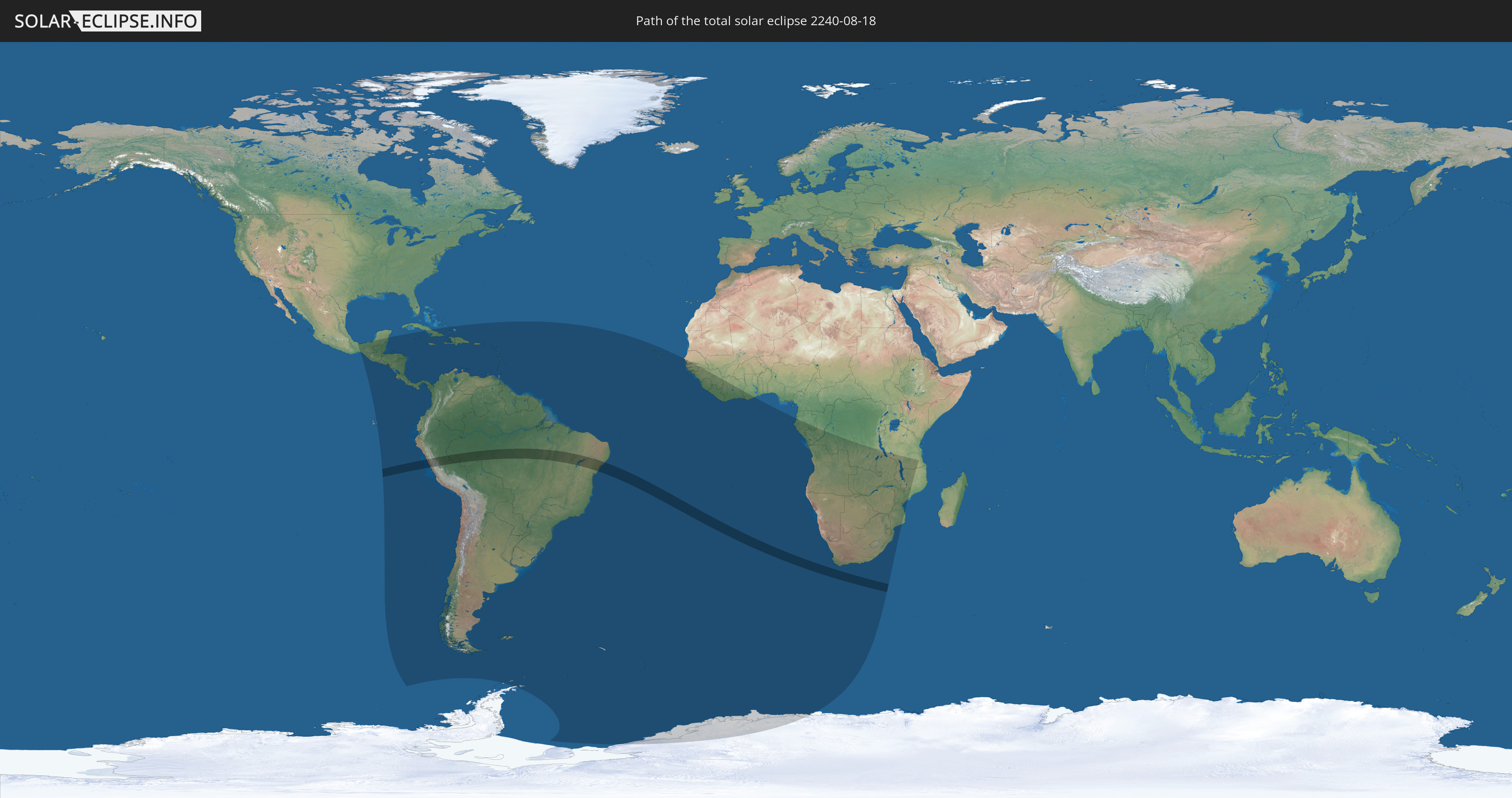
Die Sonnenfinsternis am 18.08.2240 kann man in 77 Ländern als partielle Sonnenfinsternis beobachten.
Der Finsternispfad verläuft durch 2 Länder. Nur in diesen Ländern ist sie als totale Sonnenfinsternis zu sehen.
In den folgenden Ländern ist die Sonnenfinsternis total zu sehen
 Peru
Peru
 Brasilien
In den folgenden Ländern ist die Sonnenfinsternis partiell zu sehen
 Antarktika
 United States Minor Outlying Islands
 Mexiko
 Chile
Chile
 Guatemala
 Ecuador
 El Salvador
 Honduras
 Belize
 Nicaragua
 Costa Rica
 Kuba
Kuba
 Panama
 Kolumbien
 Kaimaninseln
 Peru
Peru
 Bahamas
 Jamaika
 Haiti
Haiti
 Brasilien
 Argentinien
 Venezuela
 Turks- und Caicosinseln
 Dominikanische Republik
 Aruba
Aruba
 Bolivien
 Puerto Rico
 Amerikanische Jungferninseln
 Britische Jungferninseln
 Anguilla
 Saint-Martin
 Saint-Barthélemy
 St. Kitts und Nevis
 Paraguay
 Antigua und Barbuda
 Montserrat
 Trinidad und Tobago
 Guadeloupe
 Grenada
 Dominica
 St. Vincent und die Grenadinen
 Falklandinseln
 Guyana
 Martinique
 St. Lucia
 Barbados
 Uruguay
 Suriname
 Französisch-Guayana
 Südgeorgien und die Südlichen Sandwichinseln
 Kap Verde
 Senegal
 Gambia
 Guinea-Bissau
 Guinea
 St. Helena
 Sierra Leone
 Liberia
 Elfenbeinküste
 Ghana
Ghana
 Bouvetinsel
 Äquatorialguinea
 São Tomé und Príncipe
 Gabun
Gabun
 Republik Kongo
 Angola
 Namibia
 Demokratische Republik Kongo
 Südafrika
 Botswana
 Sambia
 Simbabwe
 Lesotho
 Tansania
 Mosambik
 Swasiland
 Malawi
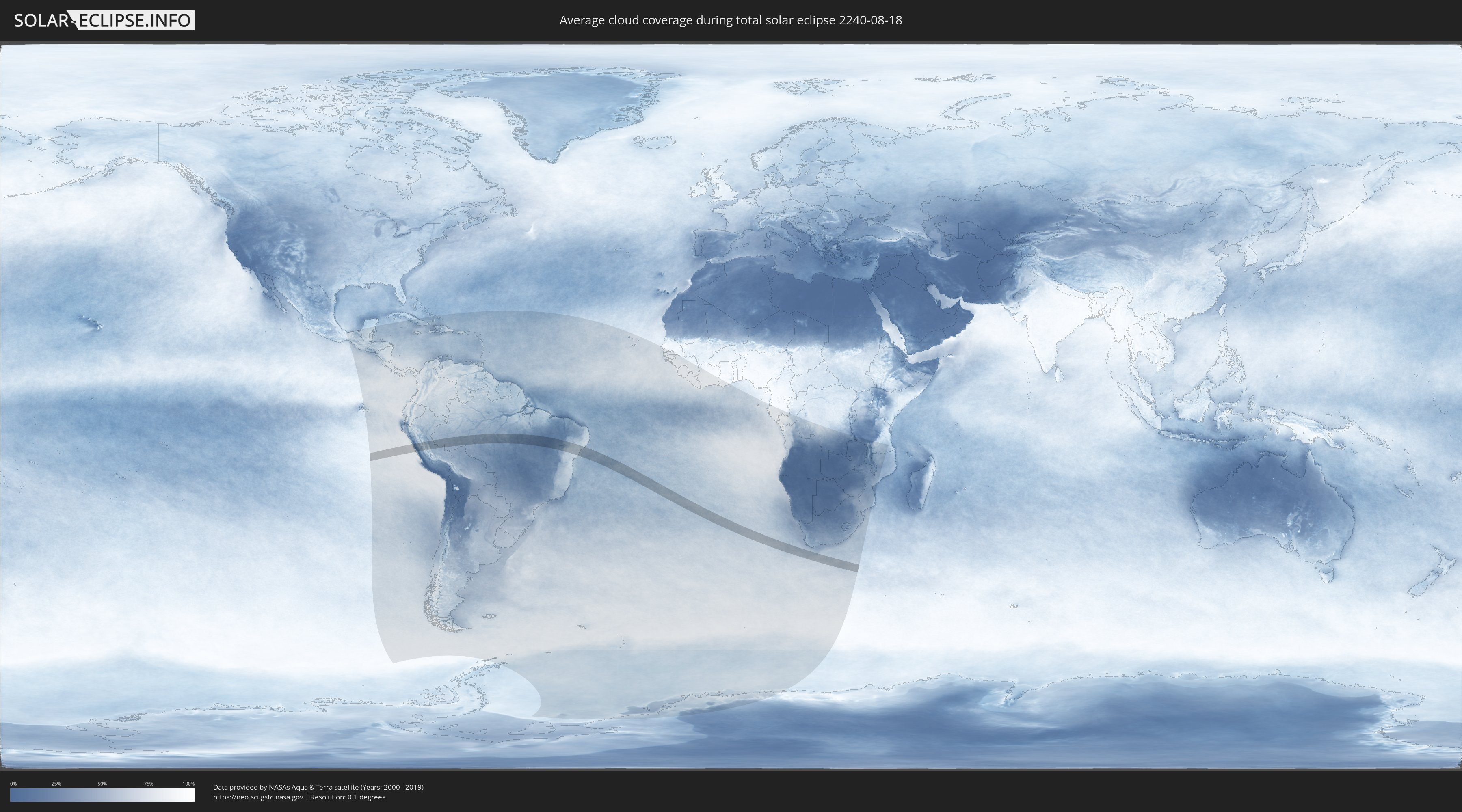
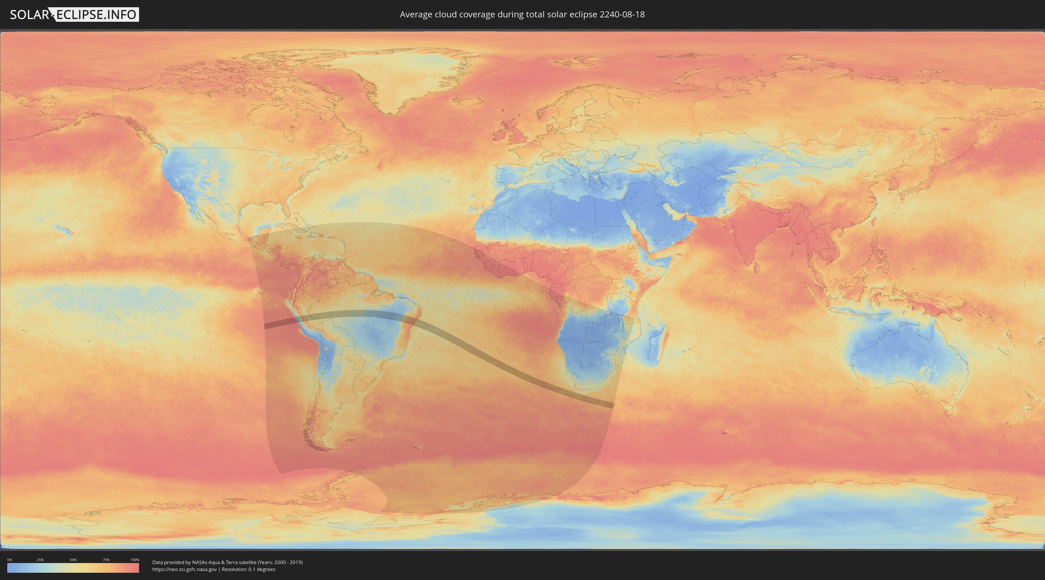
Wie wird das Wetter während der totalen Sonnenfinsternis am 18.08.2240?
Wo ist der beste Ort, um die totale Sonnenfinsternis vom 18.08.2240 zu beobachten?
Die folgenden Karten zeigen die durchschnittliche Bewölkung für den Tag, an dem die totale Sonnenfinsternis
stattfindet. Mit Hilfe der Karten lässt sich der Ort entlang des Finsternispfades eingrenzen,
der die besten Aussichen auf einen klaren wolkenfreien Himmel bietet.
Trotzdem muss man immer lokale Gegenenheiten beachten und sollte sich genau über das Wetter an seinem
gewählten Beobachtungsort informieren.
Die Daten stammen von den beiden NASA-Satelliten
AQUA und TERRA
und wurden über einen Zeitraum von 19 Jahren (2000 - 2019) gemittelt.
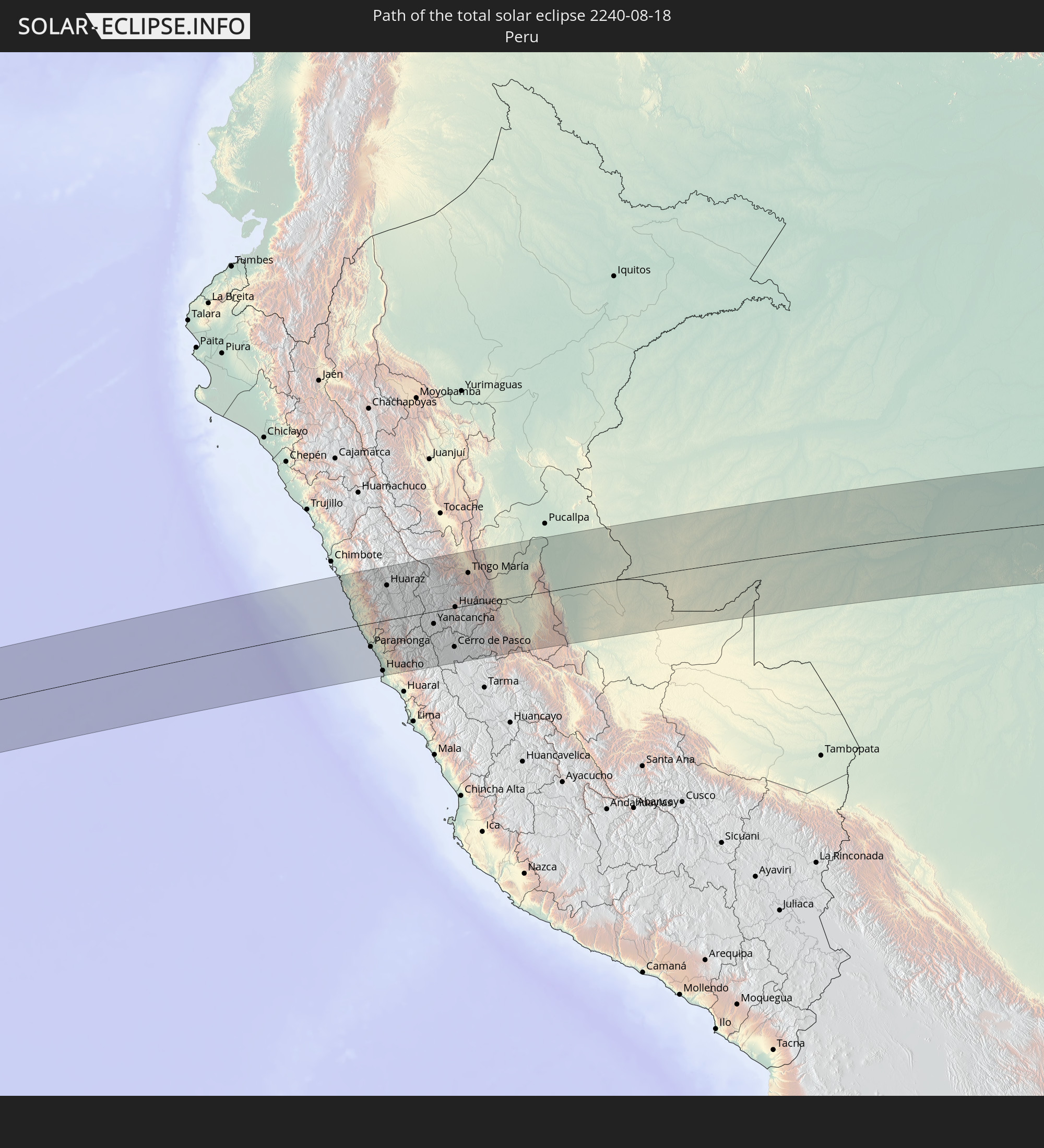
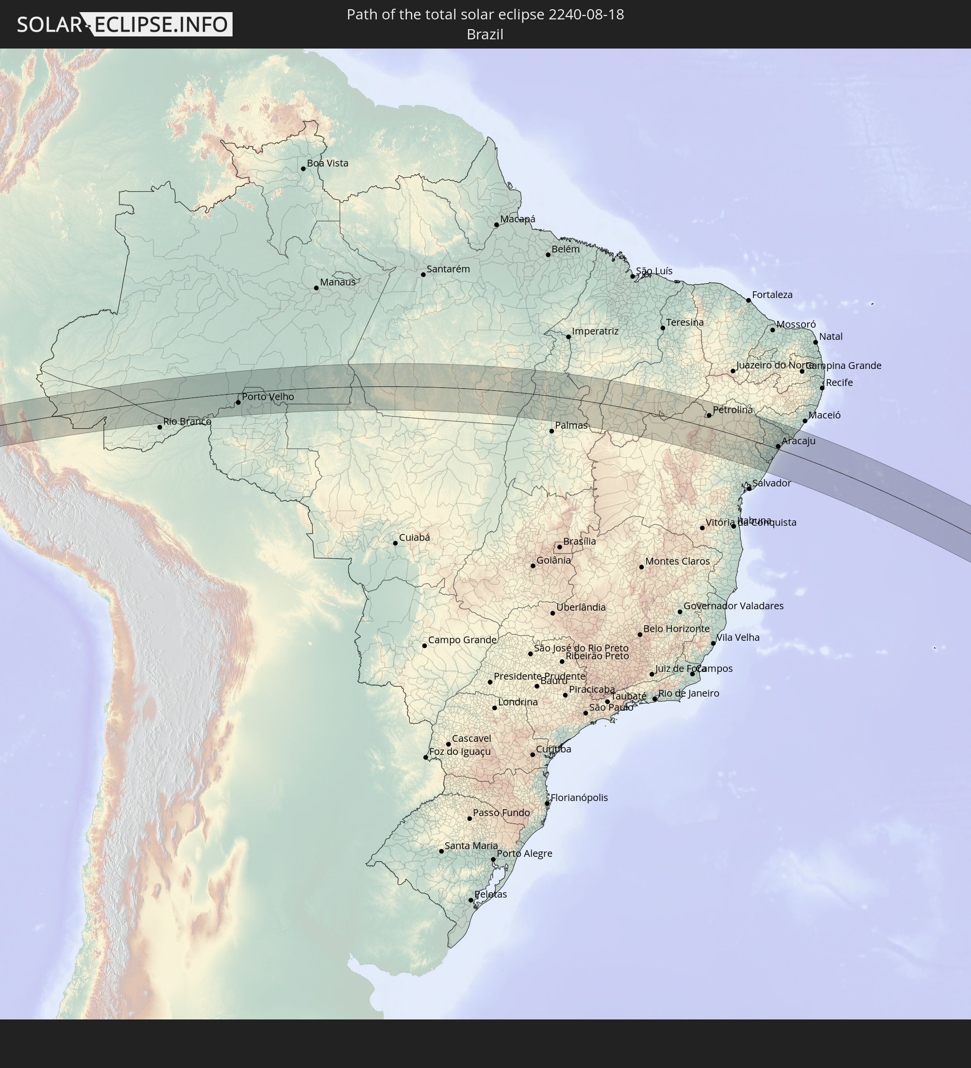
Detaillierte Länderkarten
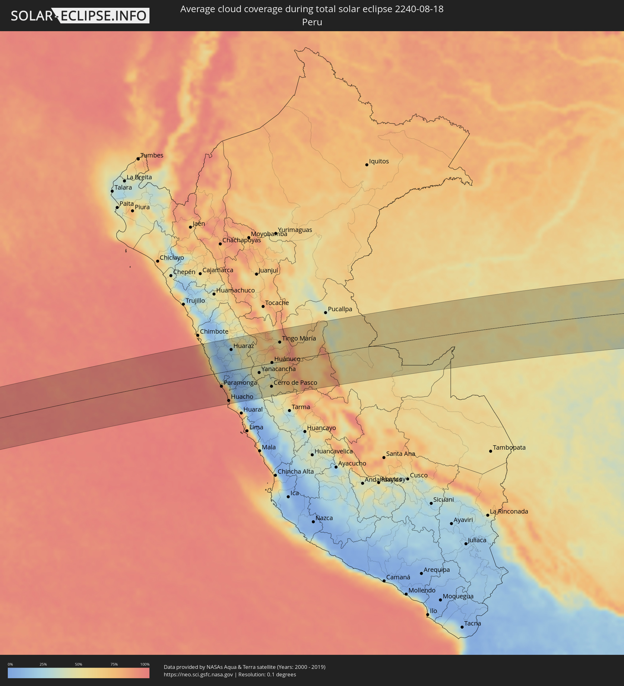 Peru
Peru
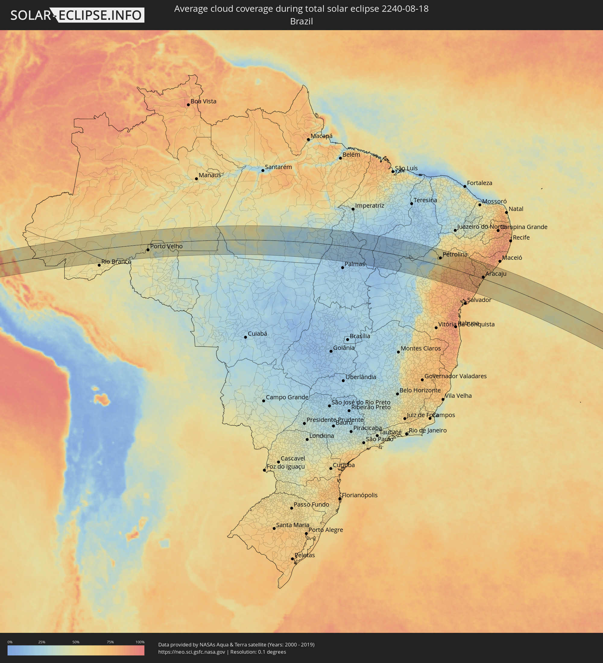 Brasilien
Orte im Finsternispfad
Die nachfolgene Tabelle zeigt Städte und Orte mit mehr als 5.000 Einwohnern, die sich im Finsternispfad befinden. Städte mit mehr als 100.000 Einwohnern sind dick gekennzeichnet. Mit einem Klick auf den Ort öffnet sich eine Detailkarte die die Lage des jeweiligen Ortes zusammen mit dem Verlauf der zentralen Finsternis präsentiert.
| Ort | Typ | Dauer der Verfinsterung | Ortszeit bei maximaler Verfinsterung | Entfernung zur Zentrallinie | Ø Bewölkung |
|
Huarmey, Ancash
|
total | - | 07:13:47 UTC-05:00 | 24 km | 80% |
|
Paramonga, Lima region
|
total | - | 07:14:22 UTC-05:00 | 48 km | 91% |
|
Pativilca, Lima region
|
total | - | 07:14:25 UTC-05:00 | 53 km | 91% |
|
Barranca, Lima region
|
total | - | 07:14:28 UTC-05:00 | 58 km | 90% |
|
Puerto Supe, Lima region
|
total | - | 07:14:31 UTC-05:00 | 65 km | 88% |
|
Supe, Lima region
|
total | - | 07:14:32 UTC-05:00 | 65 km | 88% |
|
Carhuaz, Ancash
|
total | - | 07:13:33 UTC-05:00 | 100 km | 17% |
|
Végueta, Lima region
|
total | - | 07:14:44 UTC-05:00 | 91 km | 84% |
|
Caleta de Carquín, Lima region
|
total | - | 07:14:47 UTC-05:00 | 99 km | 85% |
|
Hualmay, Lima region
|
total | - | 07:14:48 UTC-05:00 | 99 km | 85% |
|
Huacho, Lima region
|
total | - | 07:14:49 UTC-05:00 | 101 km | 85% |
|
Huaura, Lima region
|
total | - | 07:14:47 UTC-05:00 | 97 km | 85% |
|
Huaraz, Ancash
|
total | - | 07:13:47 UTC-05:00 | 70 km | 21% |
|
Oyón, Lima region
|
total | - | 07:15:01 UTC-05:00 | 69 km | 26% |
|
Yanacancha, Huanuco
|
total | - | 07:14:48 UTC-05:00 | 25 km | 51% |
|
San Miguel de Cauri, Huanuco
|
total | - | 07:14:45 UTC-05:00 | 14 km | 49% |
|
Yanahuanca, Pasco Region
|
total | - | 07:15:05 UTC-05:00 | 58 km | 42% |
|
Chaupimarca, Pasco Region
|
total | - | 07:15:02 UTC-05:00 | 47 km | 44% |
|
Tinyahuarco, Pasco Region
|
total | - | 07:15:24 UTC-05:00 | 90 km | 47% |
|
Cerro de Pasco, Pasco Region
|
total | - | 07:15:21 UTC-05:00 | 79 km | 47% |
|
Huánuco, Huanuco
|
total | - | 07:14:51 UTC-05:00 | 1 km | 47% |
|
Ambo, Huanuco
|
total | - | 07:15:00 UTC-05:00 | 22 km | 44% |
|
Carhuamayo, Junín Region
|
total | - | 07:15:40 UTC-05:00 | 111 km | 48% |
|
Tingo María, Huanuco
|
total | - | 07:14:35 UTC-05:00 | 66 km | 61% |
|
Oxapampa, Pasco Region
|
total | - | 07:15:52 UTC-05:00 | 86 km | 73% |
|
Villa Rica, Pasco Region
|
total | - | 07:16:04 UTC-05:00 | 106 km | 77% |
|
Tarauacá, Acre
|
total | - | 07:17:54 UTC-05:00 | 99 km | 57% |
|
Feijó, Acre
|
total | - | 07:18:17 UTC-05:00 | 93 km | 55% |
|
Sena Madureira, Acre
|
total | - | 07:20:33 UTC-05:00 | 31 km | 57% |
|
Boca do Acre, Amazonas
|
total | - | 08:21:41 UTC-04:00 | 14 km | 53% |
|
Pauini, Amazonas
|
total | - | 08:21:24 UTC-04:00 | 96 km | 50% |
|
Porto Velho, Rondônia
|
total | - | 08:25:52 UTC-04:00 | 54 km | 51% |
|
Humaitá, Amazonas
|
total | - | 08:26:04 UTC-04:00 | 76 km | 44% |
|
Aripuanã, Mato Grosso
|
total | - | 08:30:46 UTC-04:00 | 124 km | 42% |
|
Conceição do Araguaia, Pará
|
total | - | 09:51:02 UTC-03:00 | 6 km | 19% |
|
Carolina, Maranhão
|
total | - | 09:54:11 UTC-03:00 | 133 km | 19% |
|
Santa Luzia, Maranhão
|
total | - | 09:55:03 UTC-03:00 | 103 km | 17% |
|
Bom Jesus, Piauí
|
total | - | 10:03:21 UTC-03:00 | 1 km | 16% |
|
São Raimundo Nonato, Piauí
|
total | - | 10:07:27 UTC-03:00 | 44 km | 28% |
|
São João do Piauí, Piauí
|
total | - | 10:07:54 UTC-03:00 | 126 km | 22% |
|
Jacobina, Bahia
|
total | - | 10:15:34 UTC-03:00 | 130 km | 77% |
|
Petrolina, Pernambuco
|
total | - | 10:13:34 UTC-03:00 | 61 km | 56% |
|
Pindobaçu, Bahia
|
total | - | 10:15:28 UTC-03:00 | 78 km | 78% |
|
Campo Formoso, Bahia
|
total | - | 10:15:18 UTC-03:00 | 52 km | 76% |
|
Jaguarari, Bahia
|
total | - | 10:15:21 UTC-03:00 | 22 km | 77% |
|
Senhor do Bonfim, Bahia
|
total | - | 10:15:36 UTC-03:00 | 43 km | 79% |
|
Ponto Novo, Bahia
|
total | - | 10:16:12 UTC-03:00 | 84 km | 81% |
|
Capim Grosso, Bahia
|
total | - | 10:17:07 UTC-03:00 | 136 km | 77% |
|
Curaçá, Bahia
|
total | - | 10:14:40 UTC-03:00 | 123 km | 59% |
|
Queimadas, Bahia
|
total | - | 10:17:41 UTC-03:00 | 81 km | 81% |
|
Uauá, Bahia
|
total | - | 10:16:46 UTC-03:00 | 45 km | 72% |
|
Valente, Bahia
|
total | - | 10:18:38 UTC-03:00 | 122 km | 79% |
|
Santaluz, Bahia
|
total | - | 10:18:41 UTC-03:00 | 103 km | 81% |
|
Monte Santo, Bahia
|
total | - | 10:17:51 UTC-03:00 | 14 km | 80% |
|
Conceição do Coité, Bahia
|
total | - | 10:19:17 UTC-03:00 | 132 km | 80% |
|
Euclides da Cunha, Bahia
|
total | - | 10:18:47 UTC-03:00 | 12 km | 78% |
|
Serrinha, Bahia
|
total | - | 10:20:09 UTC-03:00 | 134 km | 83% |
|
Araci, Bahia
|
total | - | 10:19:52 UTC-03:00 | 98 km | 83% |
|
Tucano, Bahia
|
total | - | 10:19:55 UTC-03:00 | 52 km | 80% |
|
Ribeira do Pombal, Bahia
|
total | - | 10:20:27 UTC-03:00 | 30 km | 80% |
|
Cipó, Bahia
|
total | - | 10:20:49 UTC-03:00 | 58 km | 80% |
|
Nova Soure, Bahia
|
total | - | 10:21:04 UTC-03:00 | 71 km | 80% |
|
Jeremoabo, Bahia
|
total | - | 10:19:44 UTC-03:00 | 52 km | 80% |
|
Cícero Dantas, Bahia
|
total | - | 10:20:36 UTC-03:00 | 1 km | 81% |
|
Inhambupe, Bahia
|
total | - | 10:22:03 UTC-03:00 | 125 km | 80% |
|
Olindina, Bahia
|
total | - | 10:21:37 UTC-03:00 | 80 km | 80% |
|
Paulo Afonso, Bahia
|
total | - | 10:19:41 UTC-03:00 | 132 km | 74% |
|
Poço Verde, Sergipe
|
total | - | 10:21:16 UTC-03:00 | 5 km | 79% |
|
Entre Rios, Bahia
|
total | - | 10:22:58 UTC-03:00 | 132 km | 81% |
|
Acajutiba, Bahia
|
total | - | 10:22:49 UTC-03:00 | 100 km | 78% |
|
Tobias Barreto, Sergipe
|
total | - | 10:22:19 UTC-03:00 | 49 km | 81% |
|
Esplanada, Bahia
|
total | - | 10:23:10 UTC-03:00 | 112 km | 81% |
|
Rio Real, Bahia
|
total | - | 10:22:51 UTC-03:00 | 79 km | 80% |
|
Paripiranga, Bahia
|
total | - | 10:22:07 UTC-03:00 | 8 km | 77% |
|
Simão Dias, Sergipe
|
total | - | 10:22:18 UTC-03:00 | 4 km | 78% |
|
Itabaianinha, Sergipe
|
total | - | 10:22:59 UTC-03:00 | 51 km | 79% |
|
Canindé de São Francisco, Sergipe
|
total | - | 10:21:07 UTC-03:00 | 119 km | 81% |
|
Cristinápolis, Sergipe
|
total | - | 10:23:19 UTC-03:00 | 71 km | 81% |
|
Carira, Sergipe
|
total | - | 10:22:10 UTC-03:00 | 48 km | 81% |
|
Umbaúba, Sergipe
|
total | - | 10:23:28 UTC-03:00 | 58 km | 80% |
|
Lagarto, Sergipe
|
total | - | 10:22:57 UTC-03:00 | 9 km | 80% |
|
Boquim, Sergipe
|
total | - | 10:23:18 UTC-03:00 | 32 km | 81% |
|
Conde, Bahia
|
total | - | 10:24:06 UTC-03:00 | 102 km | 70% |
|
Monte Alegre de Sergipe, Sergipe
|
total | - | 10:22:09 UTC-03:00 | 88 km | 76% |
|
Frei Paulo, Sergipe
|
total | - | 10:22:50 UTC-03:00 | 34 km | 79% |
|
Campo do Brito, Sergipe
|
total | - | 10:23:10 UTC-03:00 | 16 km | 79% |
|
Salgado, Sergipe
|
total | - | 10:23:34 UTC-03:00 | 15 km | 81% |
|
Estância, Sergipe
|
total | - | 10:23:56 UTC-03:00 | 38 km | 72% |
|
Pão de Açúcar, Alagoas
|
total | - | 10:22:11 UTC-03:00 | 122 km | 73% |
|
Itabaiana, Sergipe
|
total | - | 10:23:18 UTC-03:00 | 23 km | 80% |
|
Nossa Senhora da Glória, Sergipe
|
total | - | 10:22:46 UTC-03:00 | 73 km | 76% |
|
Ribeirópolis, Sergipe
|
total | - | 10:23:09 UTC-03:00 | 39 km | 79% |
|
Areia Branca, Sergipe
|
total | - | 10:23:41 UTC-03:00 | 20 km | 82% |
|
Malhador, Sergipe
|
total | - | 10:23:35 UTC-03:00 | 31 km | 81% |
|
Porto da Folha, Sergipe
|
total | - | 10:22:48 UTC-03:00 | 110 km | 77% |
|
São Cristóvão, Sergipe
|
total | - | 10:24:17 UTC-03:00 | 3 km | 69% |
|
Nossa Senhora das Dores, Sergipe
|
total | - | 10:23:42 UTC-03:00 | 52 km | 77% |
|
Laranjeiras, Sergipe
|
total | - | 10:24:08 UTC-03:00 | 20 km | 77% |
|
Nossa Senhora do Socorro, Sergipe
|
total | - | 10:24:18 UTC-03:00 | 16 km | 73% |
|
Maruim, Sergipe
|
total | - | 10:24:18 UTC-03:00 | 30 km | 75% |
|
Aracaju, Sergipe
|
total | - | 10:24:31 UTC-03:00 | 12 km | 73% |
|
Santo Amaro das Brotas, Sergipe
|
total | - | 10:24:26 UTC-03:00 | 26 km | 73% |
|
Capela, Sergipe
|
total | - | 10:24:06 UTC-03:00 | 56 km | 78% |
|
Barra dos Coqueiros, Sergipe
|
total | - | 10:24:37 UTC-03:00 | 14 km | 61% |
|
Aquidabã, Sergipe
|
total | - | 10:23:56 UTC-03:00 | 80 km | 79% |
|
Traipu, Alagoas
|
total | - | 10:23:37 UTC-03:00 | 114 km | 70% |
|
Japaratuba, Sergipe
|
total | - | 10:24:31 UTC-03:00 | 50 km | 71% |
|
Propriá, Sergipe
|
total | - | 10:24:20 UTC-03:00 | 94 km | 72% |
|
Porto Real do Colégio, Alagoas
|
total | - | 10:24:19 UTC-03:00 | 97 km | 72% |
|
Girau do Ponciano, Alagoas
|
total | - | 10:23:59 UTC-03:00 | 129 km | 80% |
|
Penedo, Alagoas
|
total | - | 10:25:07 UTC-03:00 | 95 km | 73% |
|
Neópolis, Sergipe
|
total | - | 10:25:11 UTC-03:00 | 92 km | 73% |
|
São Sebastião, Alagoas
|
total | - | 10:24:48 UTC-03:00 | 134 km | 82% |
|
Piaçabuçu, Alagoas
|
total | - | 10:25:40 UTC-03:00 | 89 km | 58% |
|
Coruripe, Alagoas
|
total | - | 10:26:03 UTC-03:00 | 127 km | 64% |