Totale Sonnenfinsternis vom 30.06.2345
| Wochentag: | Samstag |
| Maximale Dauer der Verfinsterung: | 06m07s |
| Maximale Breite des Finsternispfades: | 272 km |
| Saroszyklus: | 142 |
| Bedeckungsgrad: | 100% |
| Magnitude: | 1.0797 |
| Gamma: | 0.3267 |
Wo kann man die Sonnenfinsternis vom 30.06.2345 sehen?
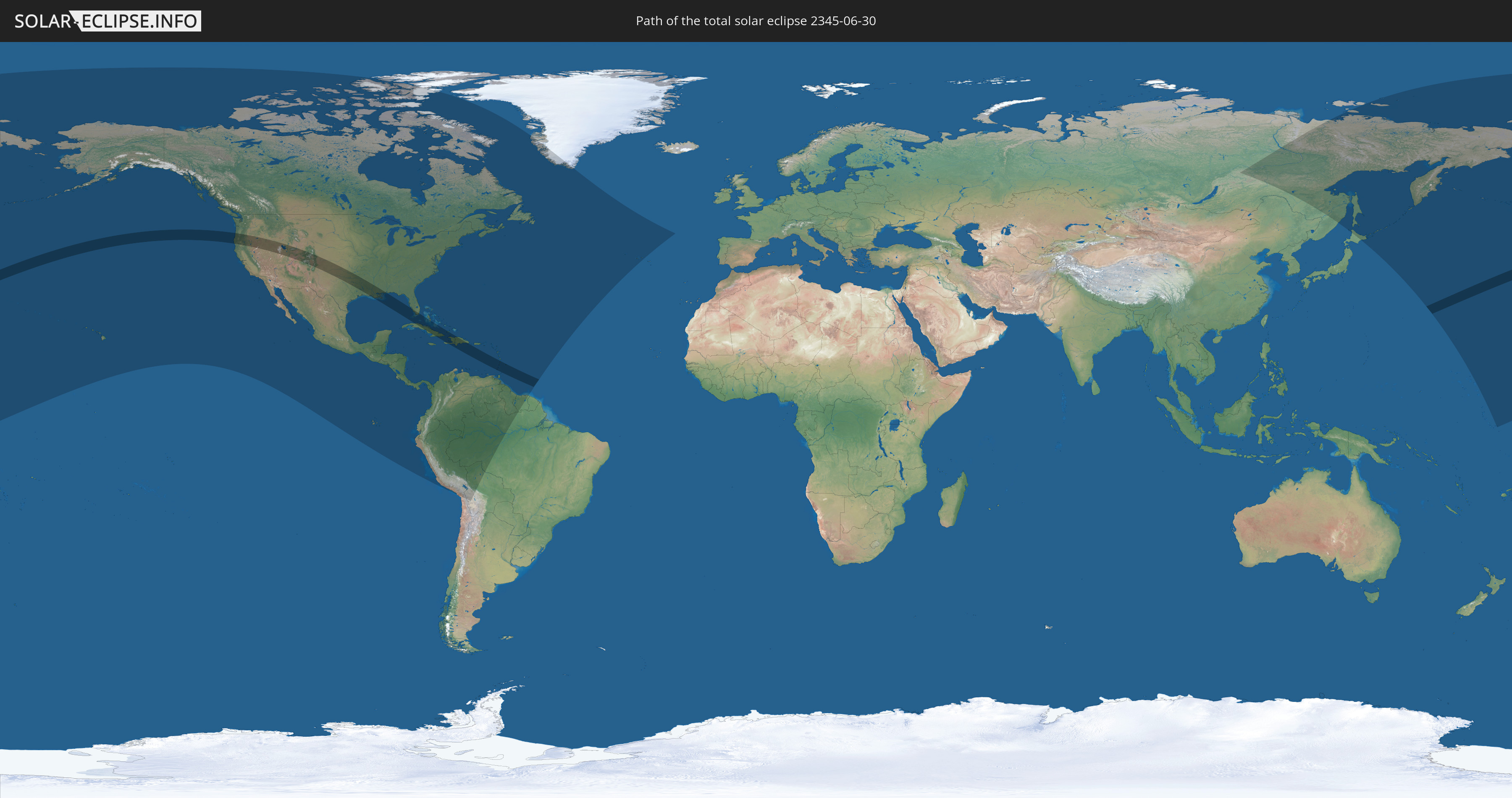
Die Sonnenfinsternis am 30.06.2345 kann man in 53 Ländern als partielle Sonnenfinsternis beobachten.
Der Finsternispfad verläuft durch 9 Länder. Nur in diesen Ländern ist sie als totale Sonnenfinsternis zu sehen.
In den folgenden Ländern ist die Sonnenfinsternis total zu sehen
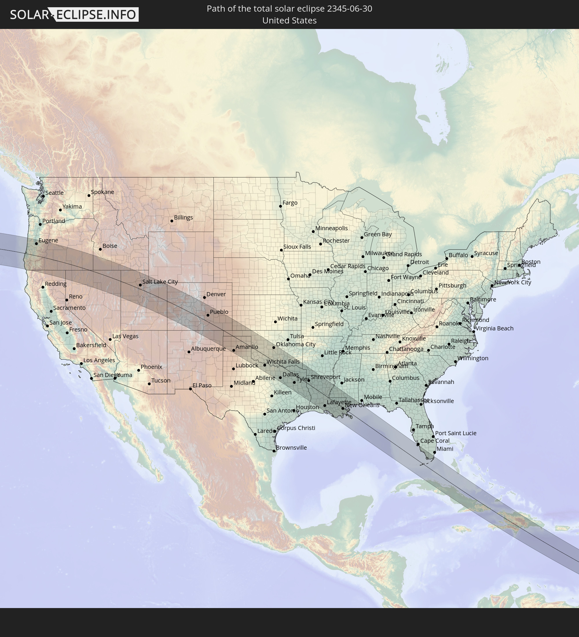 Vereinigte Staaten
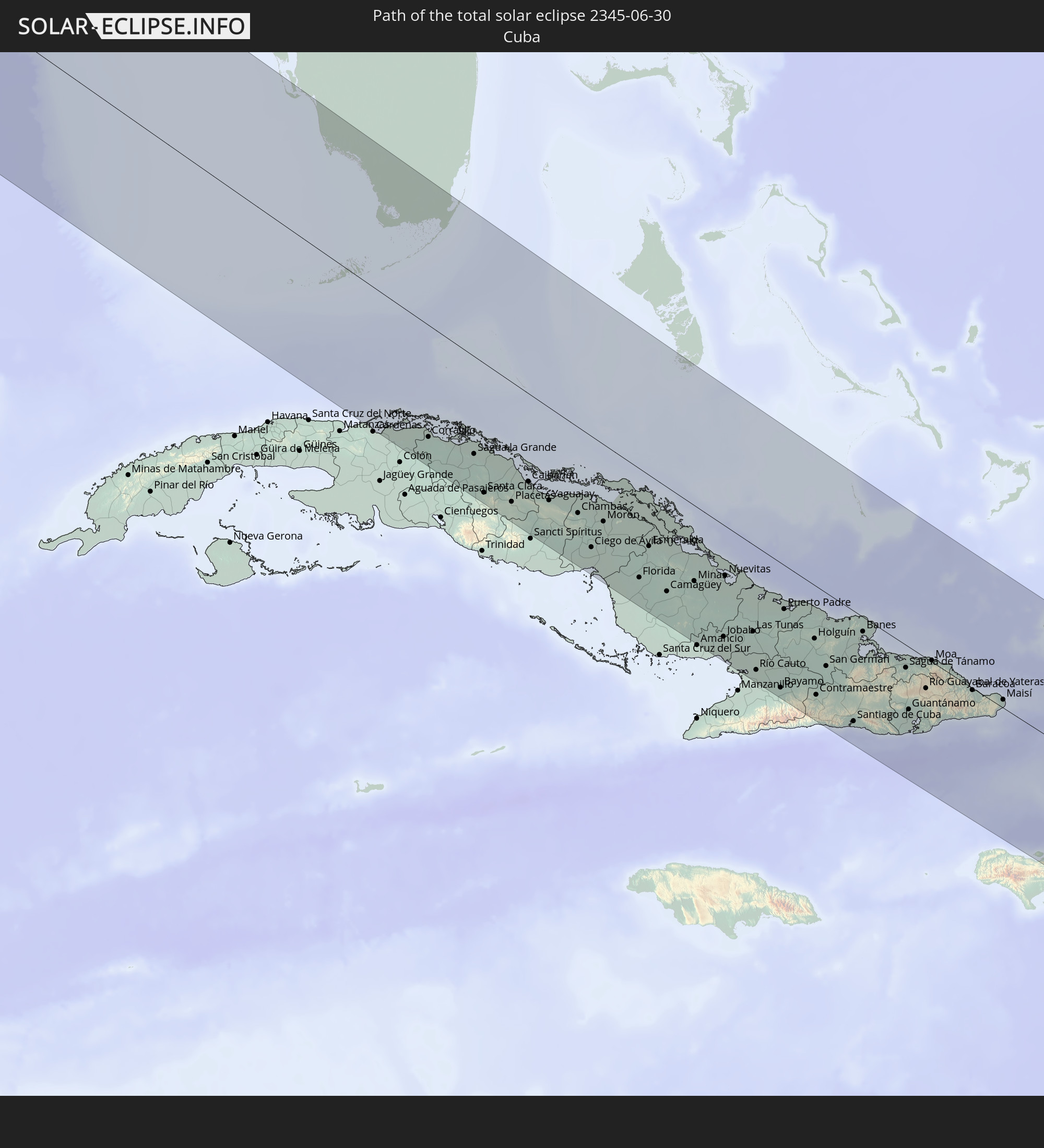 Kuba
Kuba
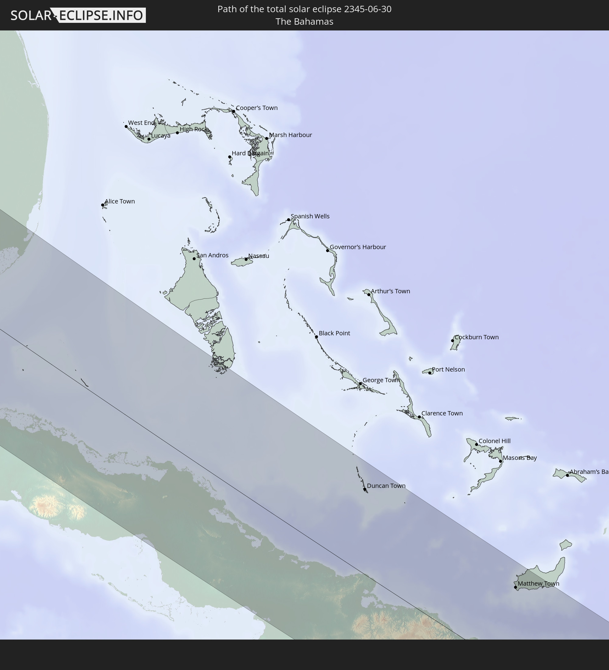 Bahamas
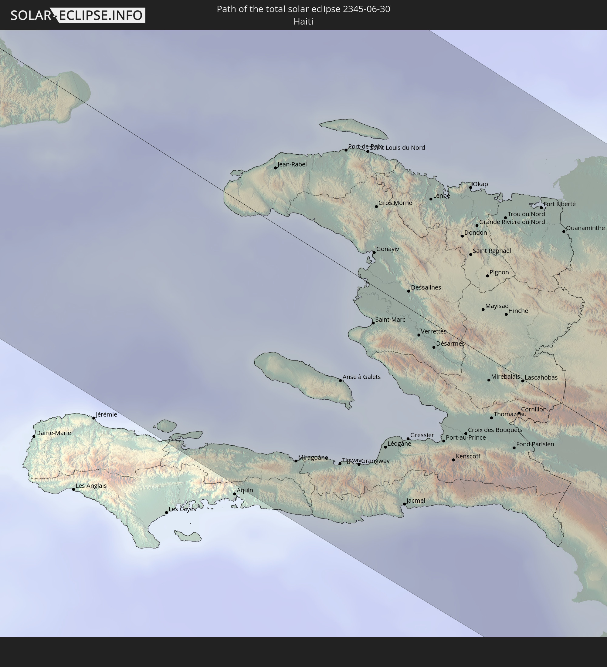 Haiti
Haiti
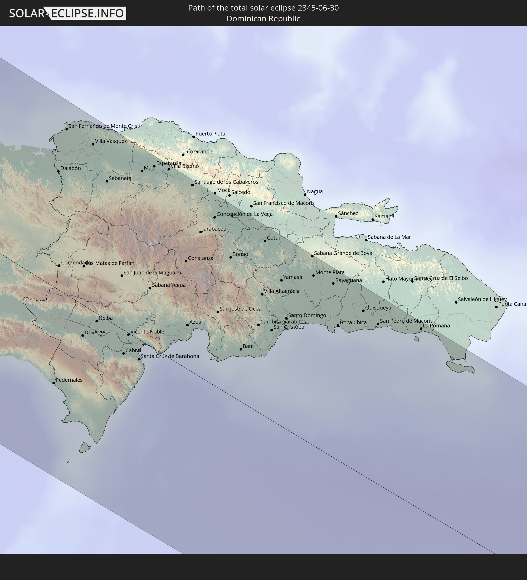 Dominikanische Republik
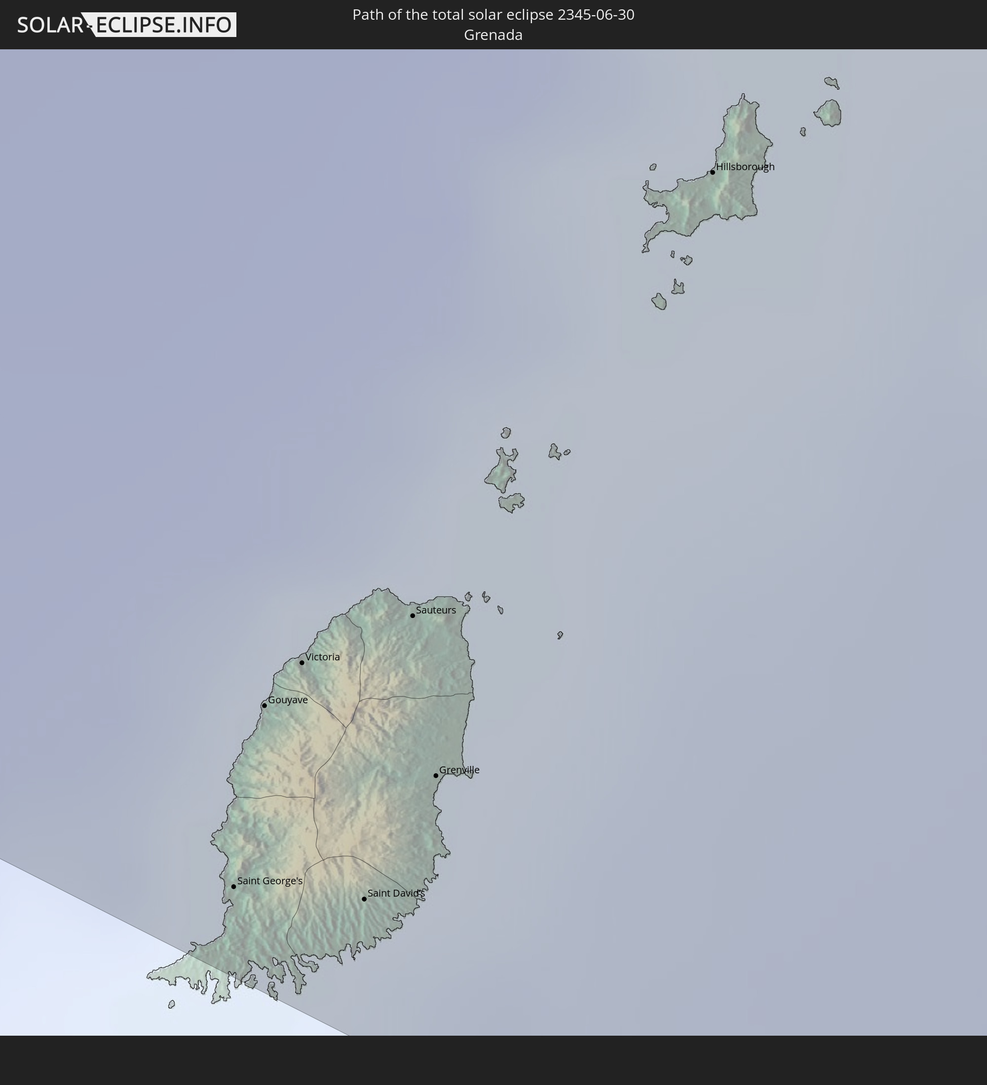 Grenada
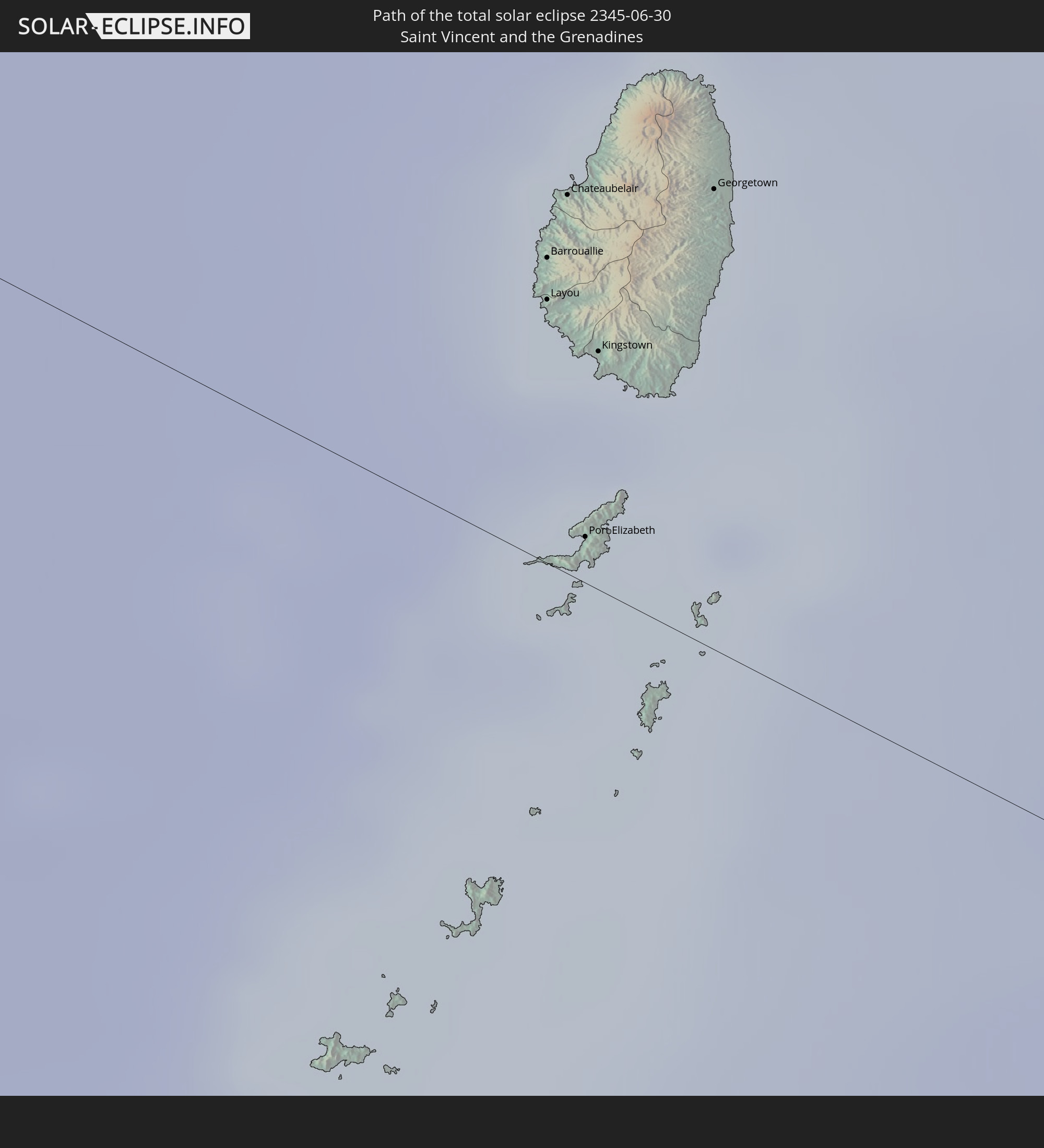 St. Vincent und die Grenadinen
 St. Lucia
 Barbados
In den folgenden Ländern ist die Sonnenfinsternis partiell zu sehen
 Russland
 Vereinigte Staaten
 United States Minor Outlying Islands
 Kiribati
 Kanada
 Mexiko
 Chile
Chile
 Grönland
 Guatemala
 Ecuador
 El Salvador
 Honduras
 Belize
 Nicaragua
 Costa Rica
 Kuba
Kuba
 Panama
 Kolumbien
 Kaimaninseln
 Peru
Peru
 Bahamas
 Jamaika
 Haiti
Haiti
 Brasilien
 Venezuela
 Turks- und Caicosinseln
 Dominikanische Republik
 Aruba
Aruba
 Bolivien
 Puerto Rico
 Amerikanische Jungferninseln
 Bermuda
 Britische Jungferninseln
 Anguilla
 Saint-Martin
 Saint-Barthélemy
 St. Kitts und Nevis
 Antigua und Barbuda
 Montserrat
 Trinidad und Tobago
 Guadeloupe
 Grenada
 Dominica
 St. Vincent und die Grenadinen
 Guyana
 Martinique
 St. Lucia
 Barbados
 Suriname
 Saint-Pierre und Miquelon
 Portugal
 Japan
Japan
 Marshallinseln
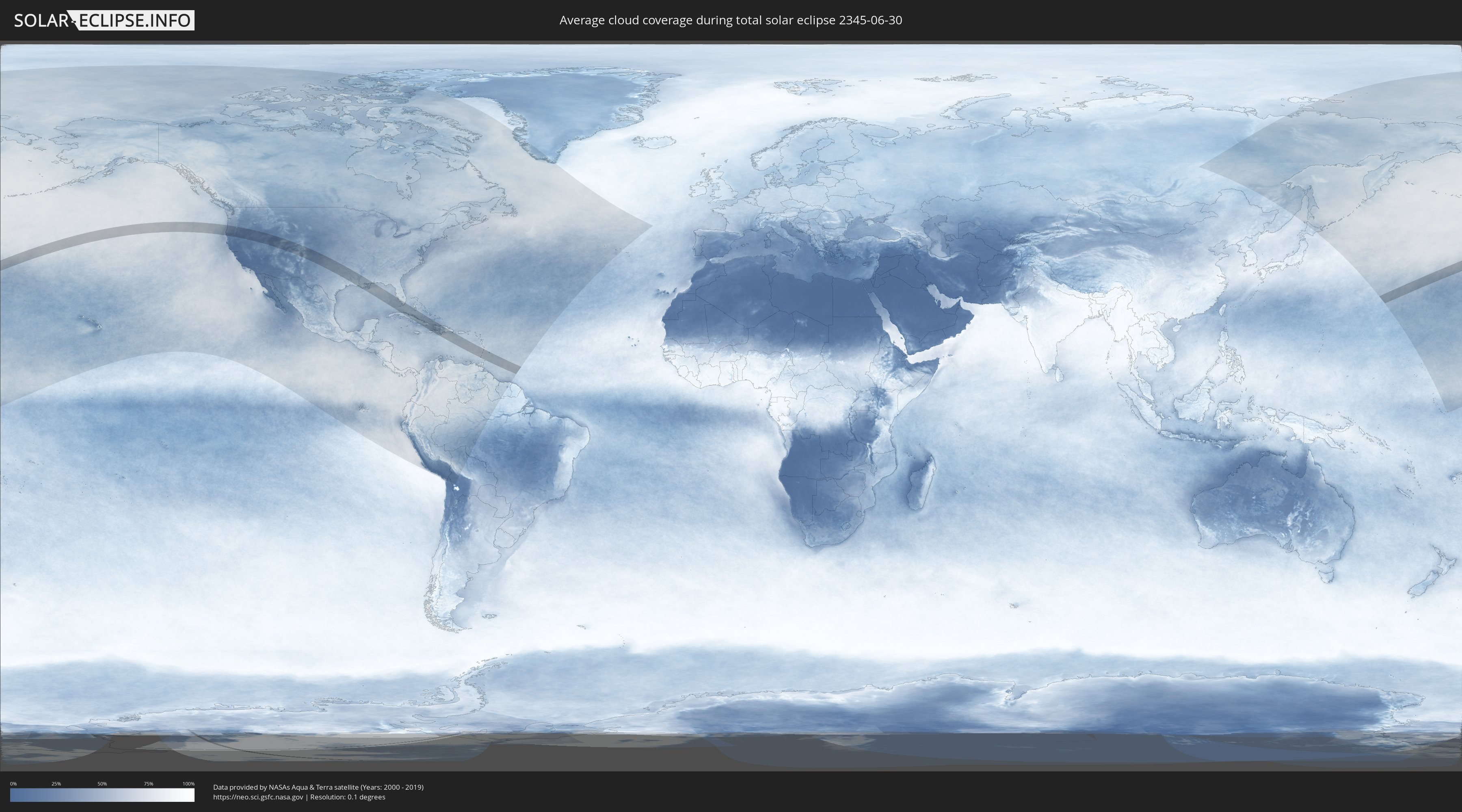
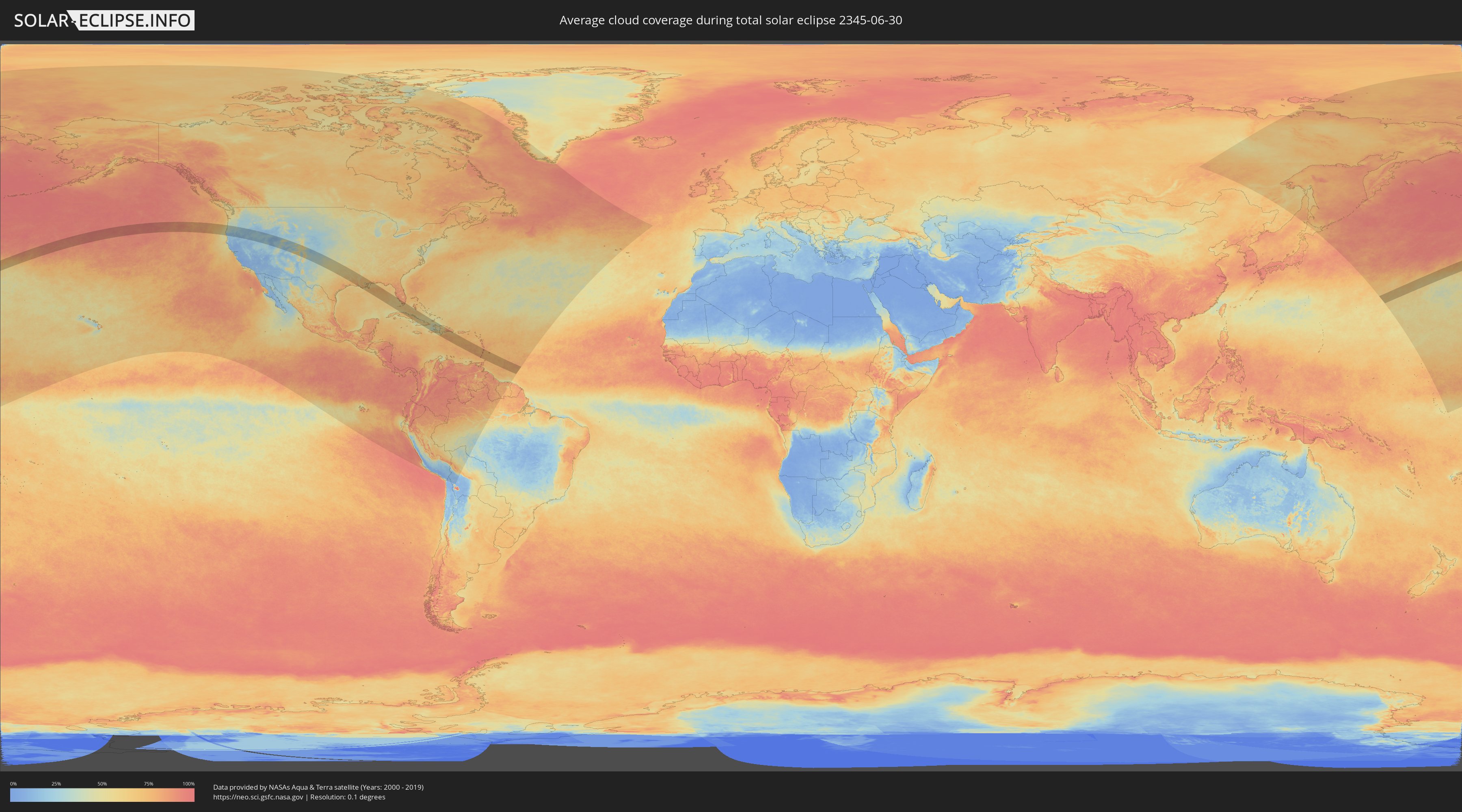
Wie wird das Wetter während der totalen Sonnenfinsternis am 30.06.2345?
Wo ist der beste Ort, um die totale Sonnenfinsternis vom 30.06.2345 zu beobachten?
Die folgenden Karten zeigen die durchschnittliche Bewölkung für den Tag, an dem die totale Sonnenfinsternis
stattfindet. Mit Hilfe der Karten lässt sich der Ort entlang des Finsternispfades eingrenzen,
der die besten Aussichen auf einen klaren wolkenfreien Himmel bietet.
Trotzdem muss man immer lokale Gegenenheiten beachten und sollte sich genau über das Wetter an seinem
gewählten Beobachtungsort informieren.
Die Daten stammen von den beiden NASA-Satelliten
AQUA und TERRA
und wurden über einen Zeitraum von 19 Jahren (2000 - 2019) gemittelt.
Detaillierte Länderkarten
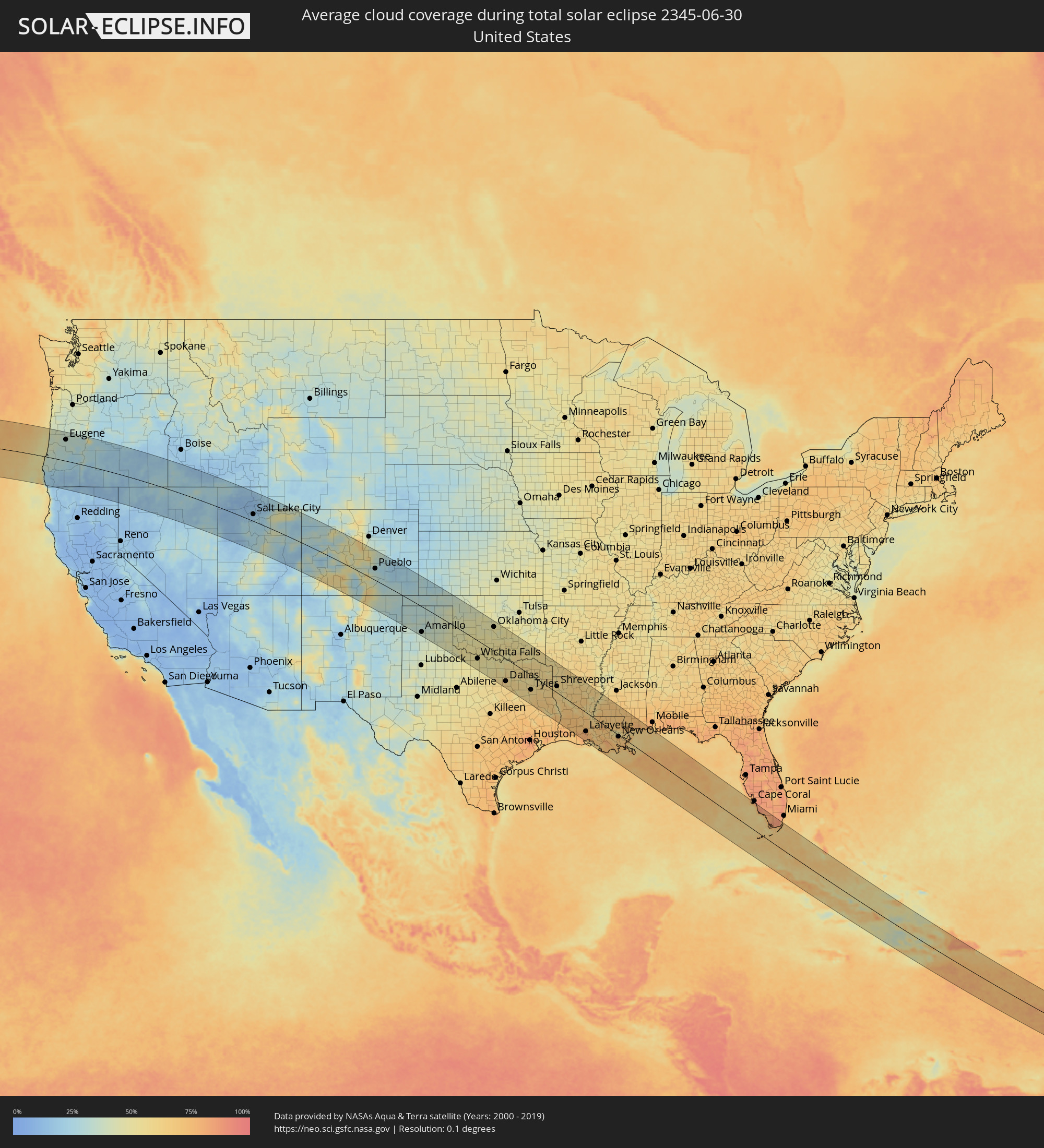 Vereinigte Staaten
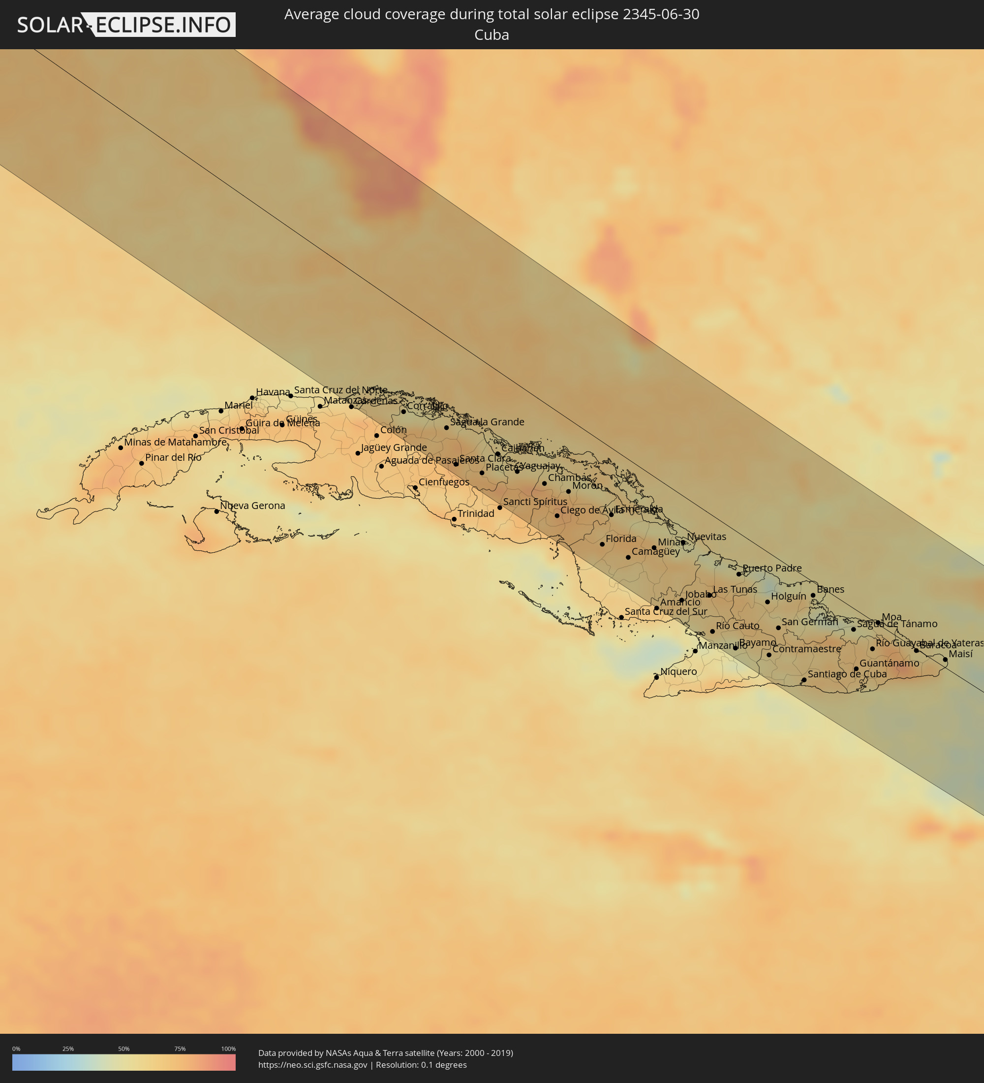 Kuba
Kuba
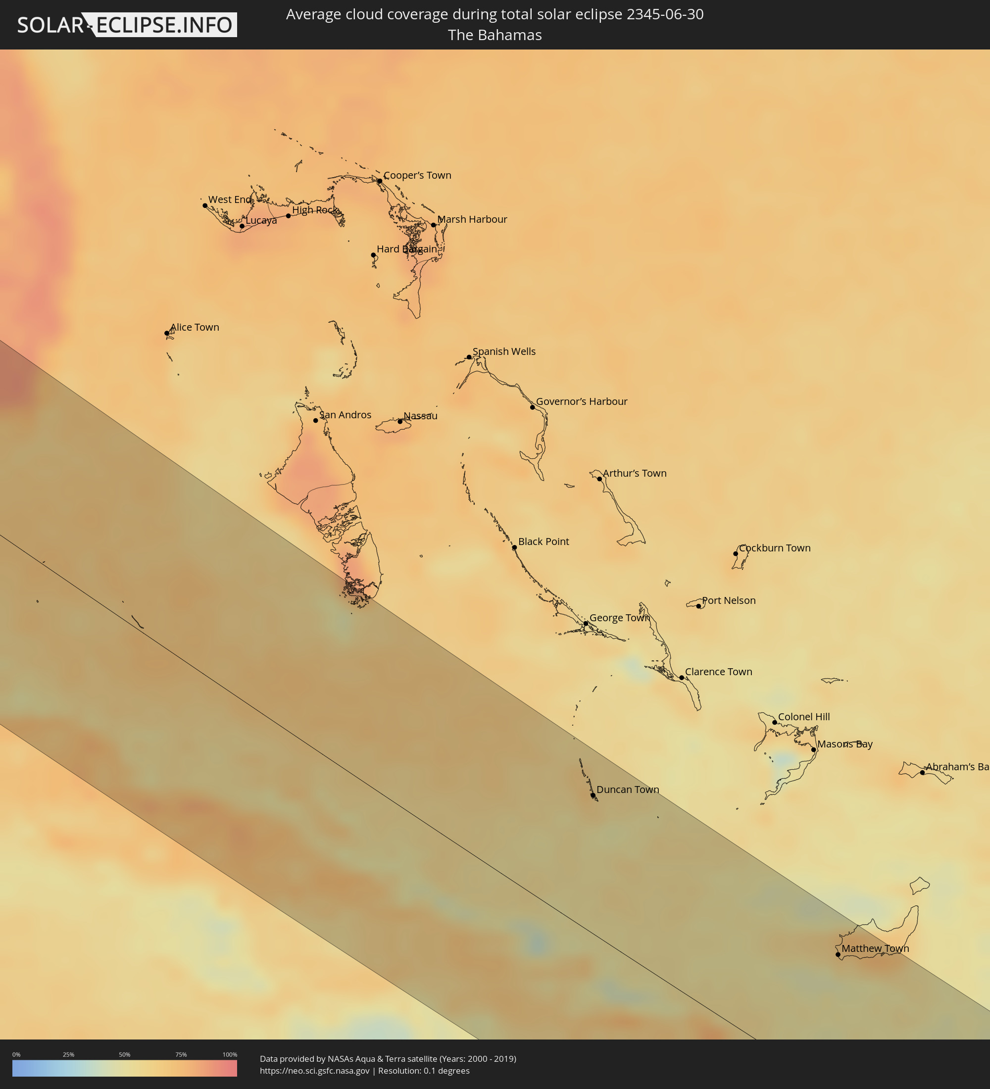 Bahamas
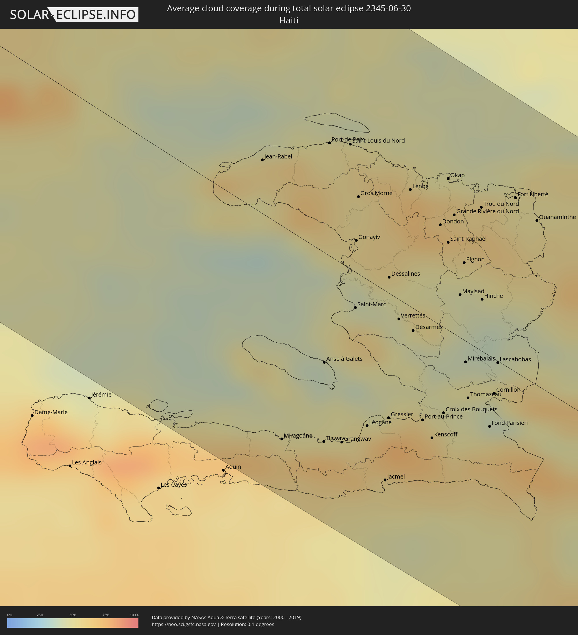 Haiti
Haiti
 Dominikanische Republik
 Grenada
 St. Vincent und die Grenadinen
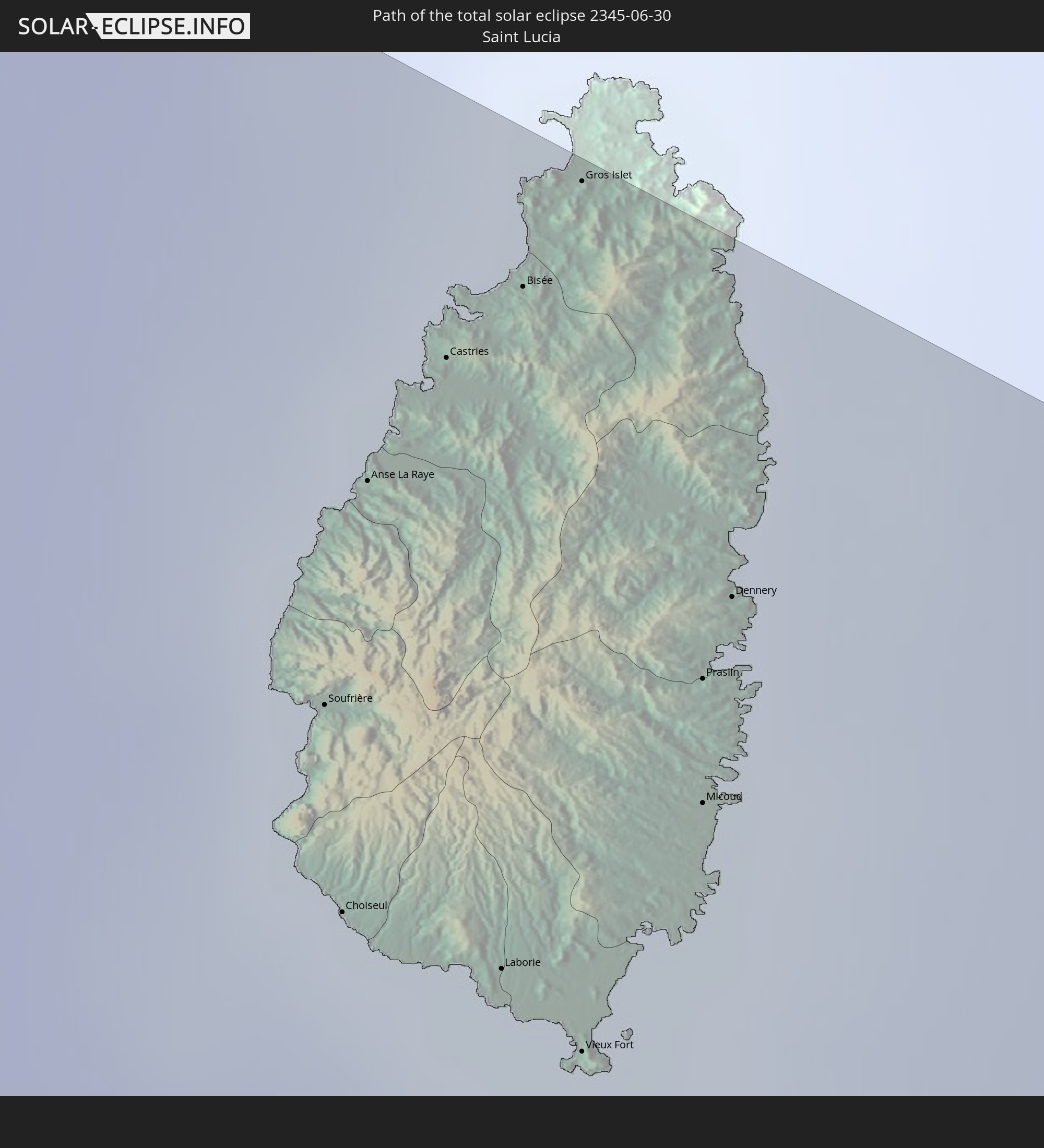
 St. Lucia
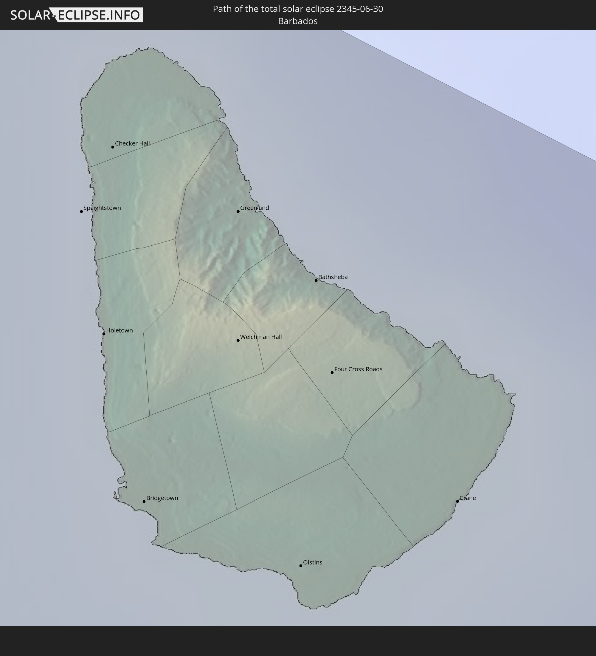
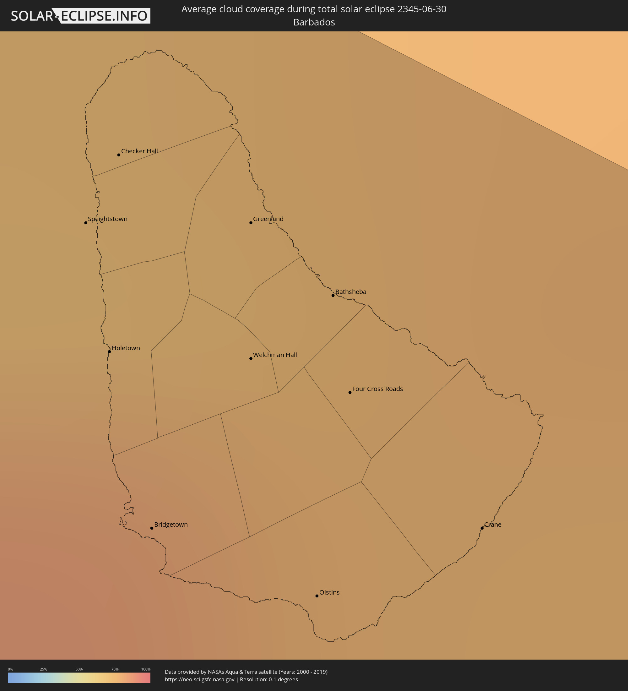 Barbados
Orte im Finsternispfad
Die nachfolgene Tabelle zeigt Städte und Orte mit mehr als 5.000 Einwohnern, die sich im Finsternispfad befinden. Städte mit mehr als 100.000 Einwohnern sind dick gekennzeichnet. Mit einem Klick auf den Ort öffnet sich eine Detailkarte die die Lage des jeweiligen Ortes zusammen mit dem Verlauf der zentralen Finsternis präsentiert.
| Ort | Typ | Dauer der Verfinsterung | Ortszeit bei maximaler Verfinsterung | Entfernung zur Zentrallinie | Ø Bewölkung |
|
Eugene, Oregon
|
total | - | 12:00:39 UTC-08:00 | 100 km | 33% |
|
West Jordan, Utah
|
total | - | 13:23:55 UTC-07:00 | 15 km | 22% |
|
Salt Lake City, Utah
|
total | - | 13:23:51 UTC-07:00 | 32 km | 16% |
|
Provo, Utah
|
total | - | 13:24:50 UTC-07:00 | 14 km | 23% |
|
Colorado Springs, Colorado
|
total | - | 13:38:23 UTC-07:00 | 101 km | 44% |
|
Pueblo, Colorado
|
total | - | 13:39:31 UTC-07:00 | 53 km | 29% |
|
Amarillo, Texas
|
total | - | 14:48:20 UTC-06:00 | 118 km | 36% |
|
Wichita Falls, Texas
|
total | - | 14:55:22 UTC-06:00 | 83 km | 50% |
|
Oklahoma City, Oklahoma
|
total | - | 14:54:22 UTC-06:00 | 111 km | 50% |
|
Norman, Oklahoma
|
total | - | 14:54:51 UTC-06:00 | 92 km | 47% |
|
Fort Worth, Texas
|
total | - | 14:58:52 UTC-06:00 | 136 km | 58% |
|
Denton, Texas
|
total | - | 14:58:22 UTC-06:00 | 81 km | 53% |
|
Arlington, Texas
|
total | - | 14:59:09 UTC-06:00 | 125 km | 59% |
|
Carrollton, Texas
|
total | - | 14:59:07 UTC-06:00 | 93 km | 60% |
|
Frisco, Texas
|
total | - | 14:58:54 UTC-06:00 | 71 km | 59% |
|
Dallas, Texas
|
total | - | 14:59:29 UTC-06:00 | 105 km | 61% |
|
Plano, Texas
|
total | - | 14:59:16 UTC-06:00 | 77 km | 60% |
|
McKinney, Texas
|
total | - | 14:59:07 UTC-06:00 | 56 km | 54% |
|
Mesquite, Texas
|
total | - | 14:59:48 UTC-06:00 | 96 km | 59% |
|
Shreveport, Louisiana
|
total | - | 15:03:54 UTC-06:00 | 30 km | 60% |
|
Lafayette, Louisiana
|
total | - | 15:09:35 UTC-06:00 | 89 km | 80% |
|
Baton Rouge, Louisiana
|
total | - | 15:10:14 UTC-06:00 | 21 km | 72% |
|
New Orleans, Louisiana
|
total | - | 15:12:12 UTC-06:00 | 7 km | 76% |
|
Corralillo, Villa Clara
|
total | - | 16:30:41 UTC-05:00 | 105 km | 56% |
|
Santo Domingo, Villa Clara
|
total | - | 16:31:27 UTC-05:00 | 122 km | 71% |
|
Sagua la Grande, Villa Clara
|
total | - | 16:31:15 UTC-05:00 | 92 km | 68% |
|
Santa Clara, Villa Clara
|
total | - | 16:31:52 UTC-05:00 | 123 km | 71% |
|
Placetas, Villa Clara
|
total | - | 16:32:11 UTC-05:00 | 114 km | 71% |
|
Ciego de Ávila, Ciego de Ávila
|
total | - | 16:33:20 UTC-05:00 | 106 km | 71% |
|
Morón, Ciego de Ávila
|
total | - | 16:33:03 UTC-05:00 | 74 km | 76% |
|
Florida, Camagüey
|
total | - | 16:34:02 UTC-05:00 | 105 km | 66% |
|
Camagüey, Camagüey
|
total | - | 16:34:24 UTC-05:00 | 100 km | 64% |
|
Jobabo, Las Tunas
|
total | - | 16:35:20 UTC-05:00 | 108 km | 57% |
|
Nuevitas, Camagüey
|
total | - | 16:34:31 UTC-05:00 | 48 km | 52% |
|
Las Tunas, Las Tunas
|
total | - | 16:35:26 UTC-05:00 | 84 km | 61% |
|
Bayamo, Granma
|
total | - | 16:36:20 UTC-05:00 | 121 km | 47% |
|
Puerto Padre, Las Tunas
|
total | - | 16:35:18 UTC-05:00 | 43 km | 62% |
|
Holguín, Holguín
|
total | - | 16:35:51 UTC-05:00 | 52 km | 60% |
|
Contramaestre, Santiago de Cuba
|
total | - | 16:36:37 UTC-05:00 | 106 km | 53% |
|
Palma Soriano, Santiago de Cuba
|
total | - | 16:36:50 UTC-05:00 | 99 km | 53% |
|
San Luis, Santiago de Cuba
|
total | - | 16:36:56 UTC-05:00 | 94 km | 57% |
|
Santiago de Cuba, Santiago de Cuba
|
total | - | 16:37:09 UTC-05:00 | 108 km | 55% |
|
Duncan Town, Ragged Island
|
total | - | 16:34:24 UTC-05:00 | 100 km | 59% |
|
Banes, Holguín
|
total | - | 16:36:00 UTC-05:00 | 14 km | 53% |
|
Guantánamo, Guantánamo
|
total | - | 16:37:15 UTC-05:00 | 61 km | 62% |
|
Moa, Holguín
|
total | - | 16:36:43 UTC-05:00 | 1 km | 51% |
|
Baracoa, Guantánamo
|
total | - | 16:37:17 UTC-05:00 | 2 km | 75% |
|
Matthew Town, Inagua
|
total | - | 16:36:51 UTC-05:00 | 101 km | 46% |
|
Miragoâne, Nippes
|
total | - | 16:40:07 UTC-05:00 | 102 km | 64% |
|
Tigwav, Ouest
|
total | - | 16:40:13 UTC-05:00 | 90 km | 70% |
|
Ti Port-de-Paix, Nord-Ouest
|
total | - | 16:38:24 UTC-05:00 | 53 km | 52% |
|
Port-de-Paix, Nord-Ouest
|
total | - | 16:38:24 UTC-05:00 | 53 km | 52% |
|
Saint-Louis du Nord, Nord-Ouest
|
total | - | 16:38:27 UTC-05:00 | 59 km | 57% |
|
Saint-Marc, Artibonite
|
total | - | 16:39:27 UTC-05:00 | 17 km | 59% |
|
Gonayiv, Artibonite
|
total | - | 16:39:03 UTC-05:00 | 15 km | 47% |
|
Léogâne, Ouest
|
total | - | 16:40:11 UTC-05:00 | 70 km | 66% |
|
Jacmel, Sud-Est
|
total | - | 16:40:33 UTC-05:00 | 91 km | 55% |
|
Gressier, Ouest
|
total | - | 16:40:11 UTC-05:00 | 60 km | 58% |
|
Dessalines, Artibonite
|
total | - | 16:39:20 UTC-05:00 | 8 km | 49% |
|
Verrettes, Artibonite
|
total | - | 16:39:36 UTC-05:00 | 9 km | 45% |
|
Lenbe, Nord
|
total | - | 16:38:50 UTC-05:00 | 56 km | 69% |
|
Désarmes, Artibonite
|
total | - | 16:39:41 UTC-05:00 | 11 km | 44% |
|
Port-au-Prince, Ouest
|
total | - | 16:40:15 UTC-05:00 | 51 km | 64% |
|
Okap, Nord
|
total | - | 16:38:49 UTC-05:00 | 72 km | 50% |
|
Saint-Raphaël, Nord
|
total | - | 16:39:13 UTC-05:00 | 42 km | 49% |
|
Thomazeau, Ouest
|
total | - | 16:40:11 UTC-05:00 | 27 km | 45% |
|
Trou du Nord, Nord-Est
|
total | - | 16:39:03 UTC-05:00 | 68 km | 63% |
|
Hinche, Centre
|
total | - | 16:39:37 UTC-05:00 | 25 km | 43% |
|
Fond Parisien, Ouest
|
total | - | 16:40:23 UTC-05:00 | 34 km | 56% |
|
Fort Liberté, Nord-Est
|
total | - | 16:39:03 UTC-05:00 | 83 km | 52% |
|
Ouanaminthe, Nord-Est
|
total | - | 16:39:13 UTC-05:00 | 79 km | 55% |
|
San Fernando de Monte Cristi, Monte Cristi
|
total | - | 17:38:53 UTC-04:00 | 111 km | 56% |
|
Las Matas de Farfán, San Juan
|
total | - | 17:40:05 UTC-04:00 | 26 km | 45% |
|
Neiba, Baoruco
|
total | - | 17:40:35 UTC-04:00 | 5 km | 66% |
|
San Juan de la Maguana, San Juan
|
total | - | 17:40:15 UTC-04:00 | 36 km | 55% |
|
Santa Cruz de Barahona, Barahona
|
total | - | 17:40:59 UTC-04:00 | 14 km | 60% |
|
Mao, Valverde
|
total | - | 17:39:24 UTC-04:00 | 115 km | 50% |
|
Villa Bisonó, Santiago
|
total | - | 17:39:26 UTC-04:00 | 127 km | 55% |
|
Constanza, La Vega
|
total | - | 17:40:15 UTC-04:00 | 73 km | 62% |
|
Azua, Azua
|
total | - | 17:40:47 UTC-04:00 | 30 km | 57% |
|
Santiago de los Caballeros, Santiago
|
total | - | 17:39:37 UTC-04:00 | 127 km | 63% |
|
Jarabacoa, La Vega
|
total | - | 17:40:02 UTC-04:00 | 98 km | 61% |
|
Concepción de La Vega, La Vega
|
total | - | 17:39:56 UTC-04:00 | 114 km | 66% |
|
San José de Ocoa, San José de Ocoa
|
total | - | 17:40:44 UTC-04:00 | 51 km | 66% |
|
Bonao, Monseñor Nouel
|
total | - | 17:40:18 UTC-04:00 | 94 km | 70% |
|
Baní, Peravia
|
total | - | 17:41:05 UTC-04:00 | 36 km | 68% |
|
Villa Altagracia, San Cristóbal
|
total | - | 17:40:40 UTC-04:00 | 82 km | 84% |
|
Cotuí, Sánchez Ramírez
|
total | - | 17:40:14 UTC-04:00 | 119 km | 78% |
|
Santo Domingo, Nacional
|
total | - | 17:40:55 UTC-04:00 | 75 km | 79% |
|
Bayaguana, Monte Plata
|
total | - | 17:40:42 UTC-04:00 | 119 km | 84% |
|
Boca Chica, Santo Domingo
|
total | - | 17:41:03 UTC-04:00 | 92 km | 76% |
|
Quisqueya, San Pedro de Macorís
|
total | - | 17:40:59 UTC-04:00 | 113 km | 83% |
|
San Pedro de Macorís, San Pedro de Macorís
|
total | - | 17:41:06 UTC-04:00 | 110 km | 74% |
|
La Romana, La Romana
|
total | - | 17:41:13 UTC-04:00 | 124 km | 72% |
|
Saint George's, Saint George
|
total | - | 17:48:10 UTC-04:00 | 116 km | 85% |
|
Gouyave, Saint John
|
total | - | 17:48:04 UTC-04:00 | 105 km | 89% |
|
Victoria, Saint Mark
|
total | - | 17:48:02 UTC-04:00 | 101 km | 89% |
|
Saint David’s, Saint David
|
total | - | 17:48:10 UTC-04:00 | 113 km | 80% |
|
Sauteurs, Saint Patrick
|
total | - | 17:48:00 UTC-04:00 | 95 km | 82% |
|
Grenville, Saint Andrew
|
total | - | 17:48:05 UTC-04:00 | 104 km | 81% |
|
Hillsborough, Carriacou and Petite Martinique
|
total | - | 17:47:45 UTC-04:00 | 60 km | 82% |
|
Layou, Saint Andrew
|
total | - | 17:47:05 UTC-04:00 | 21 km | 78% |
|
Barrouallie, Saint Patrick
|
total | - | 17:47:04 UTC-04:00 | 24 km | 78% |
|
Chateaubelair, Saint David
|
total | - | 17:47:01 UTC-04:00 | 30 km | 83% |
|
Port Elizabeth, Grenadines
|
total | - | 17:47:16 UTC-04:00 | 4 km | 81% |
|
Kingstown Park, Saint George
|
total | - | 17:47:08 UTC-04:00 | 18 km | 83% |
|
Kingstown, Saint George
|
total | - | 17:47:07 UTC-04:00 | 19 km | 83% |
|
Georgetown, Charlotte
|
total | - | 17:47:00 UTC-04:00 | 36 km | 84% |
|
Soufrière, Soufrière
|
total | - | 17:46:28 UTC-04:00 | 96 km | 83% |
|
Choiseul, Choiseul Quarter
|
total | - | 17:46:33 UTC-04:00 | 88 km | 82% |
|
Anse La Raye, Anse-la-Raye
|
total | - | 17:46:23 UTC-04:00 | 106 km | 87% |
|
Castries, Castries Quarter
|
total | - | 17:46:20 UTC-04:00 | 112 km | 86% |
|
Laborie, Laborie Quarter
|
total | - | 17:46:34 UTC-04:00 | 89 km | 82% |
|
Bisée, Castries Quarter
|
total | - | 17:46:18 UTC-04:00 | 117 km | 86% |
|
Gros Islet, Gros-Islet
|
total | - | 17:46:16 UTC-04:00 | 122 km | 83% |
|
Vieux Fort, Vieux-Fort
|
total | - | 17:46:35 UTC-04:00 | 88 km | 79% |
|
Micoud, Micoud Quarter
|
total | - | 17:46:30 UTC-04:00 | 100 km | 82% |
|
Praslin, Praslin
|
total | - | 17:46:27 UTC-04:00 | 105 km | 83% |
|
Dennery, Dennery Quarter
|
total | - | 17:46:25 UTC-04:00 | 109 km | 83% |
|
Speightstown, Saint Peter
|
total | - | 17:46:54 UTC-04:00 | 106 km | 82% |
|
Holetown, Saint James
|
total | - | 17:46:58 UTC-04:00 | 100 km | 83% |
|
Checker Hall, Saint Lucy
|
total | - | 17:46:52 UTC-04:00 | 110 km | 71% |
|
Bridgetown, Saint Michael
|
total | - | 17:47:02 UTC-04:00 | 93 km | 81% |
|
Greenland, Saint Andrew
|
total | - | 17:46:54 UTC-04:00 | 110 km | 71% |
|
Welchman Hall, Saint Thomas
|
total | - | 17:46:57 UTC-04:00 | 103 km | 83% |
|
Oistins, Christ Church
|
total | - | 17:47:03 UTC-04:00 | 93 km | 79% |
|
Bathsheba, Saint Joseph
|
total | - | 17:46:55 UTC-04:00 | 108 km | 76% |
|
Four Cross Roads, Saint John
|
total | - | 17:46:58 UTC-04:00 | 104 km | 76% |
|
Crane, Saint Philip
|
total | - | 17:47:01 UTC-04:00 | 101 km | 79% |