Totale Sonnenfinsternis vom 16.08.2566
| Wochentag: | Samstag |
| Maximale Dauer der Verfinsterung: | 04m46s |
| Maximale Breite des Finsternispfades: | 190 km |
| Saroszyklus: | 154 |
| Bedeckungsgrad: | 100% |
| Magnitude: | 1.0569 |
| Gamma: | 0.1581 |
Wo kann man die Sonnenfinsternis vom 16.08.2566 sehen?
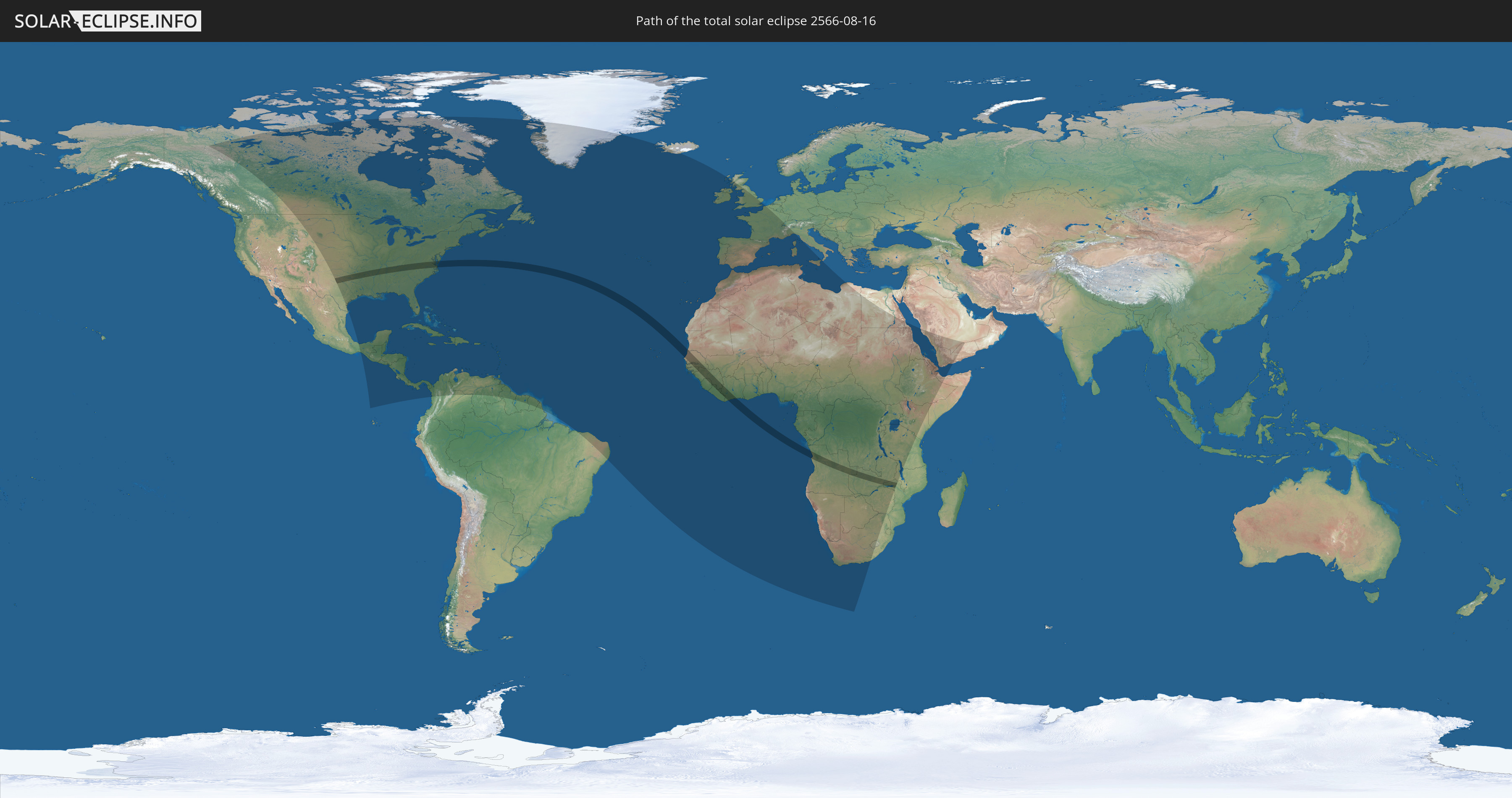
Die Sonnenfinsternis am 16.08.2566 kann man in 111 Ländern als partielle Sonnenfinsternis beobachten.
Der Finsternispfad verläuft durch 12 Länder. Nur in diesen Ländern ist sie als totale Sonnenfinsternis zu sehen.
In den folgenden Ländern ist die Sonnenfinsternis total zu sehen
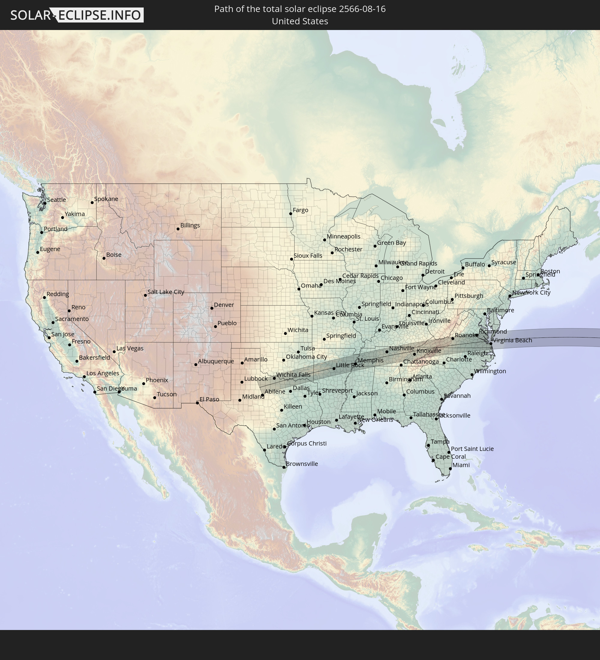 Vereinigte Staaten
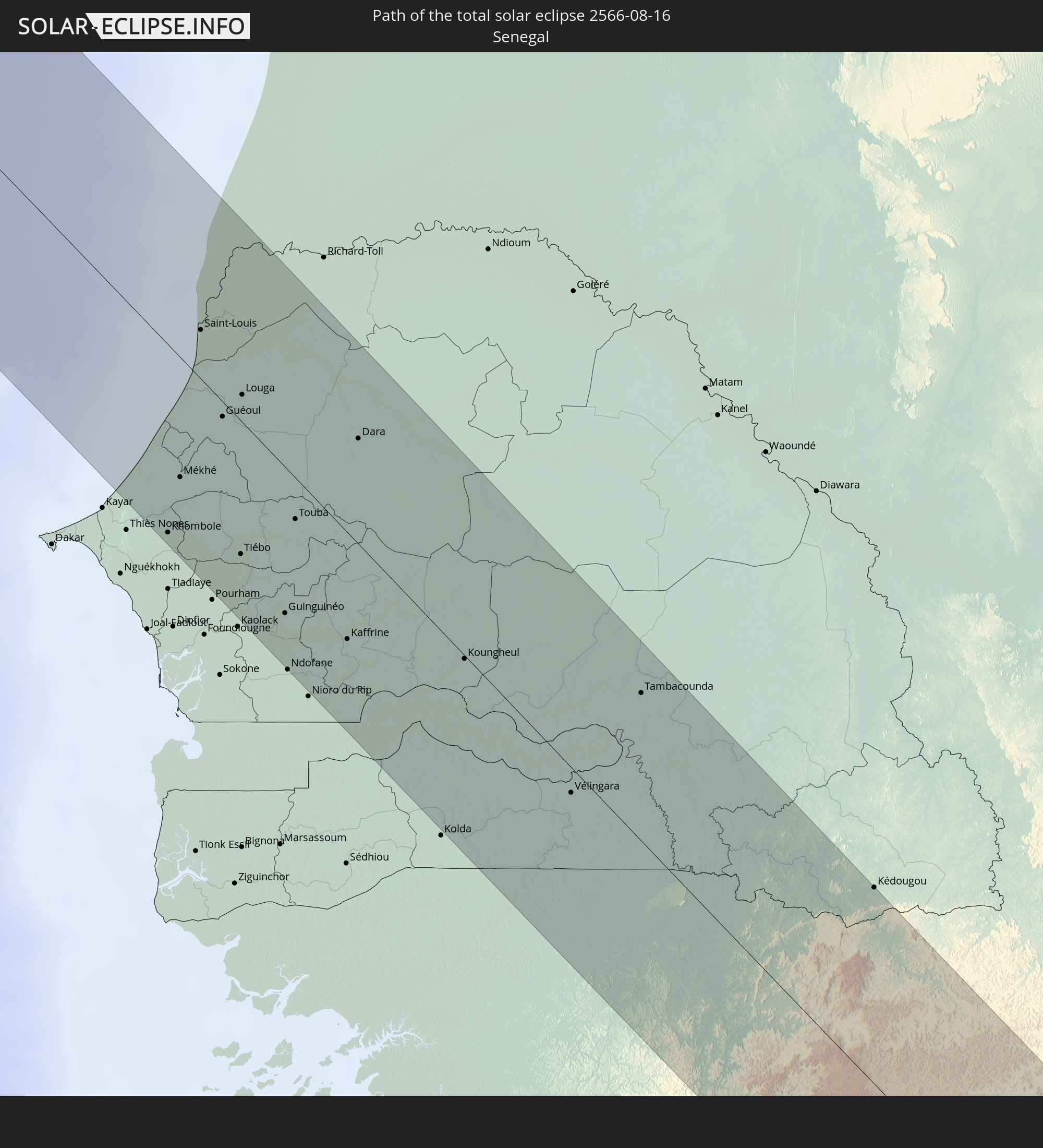 Senegal
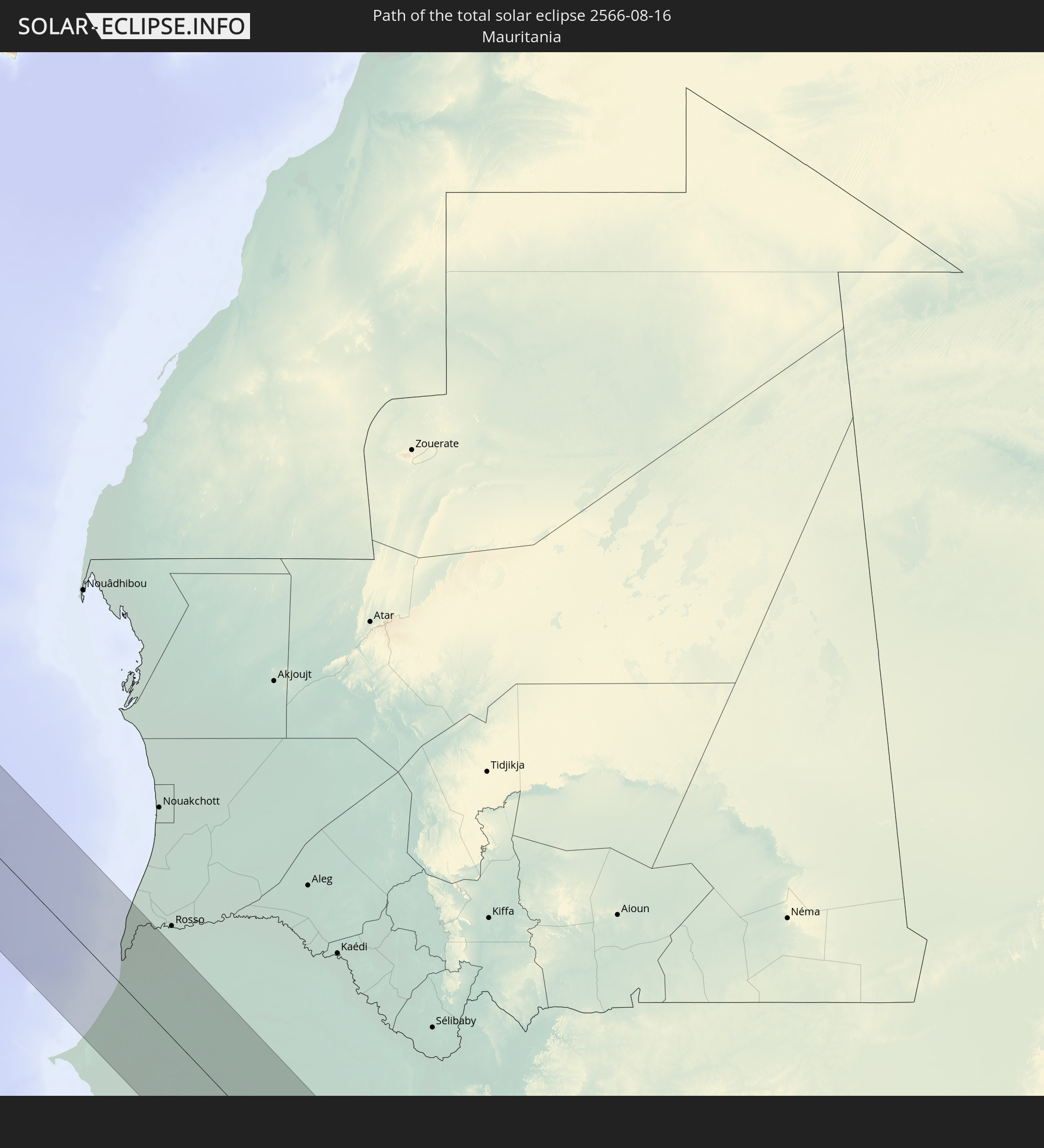 Mauretanien
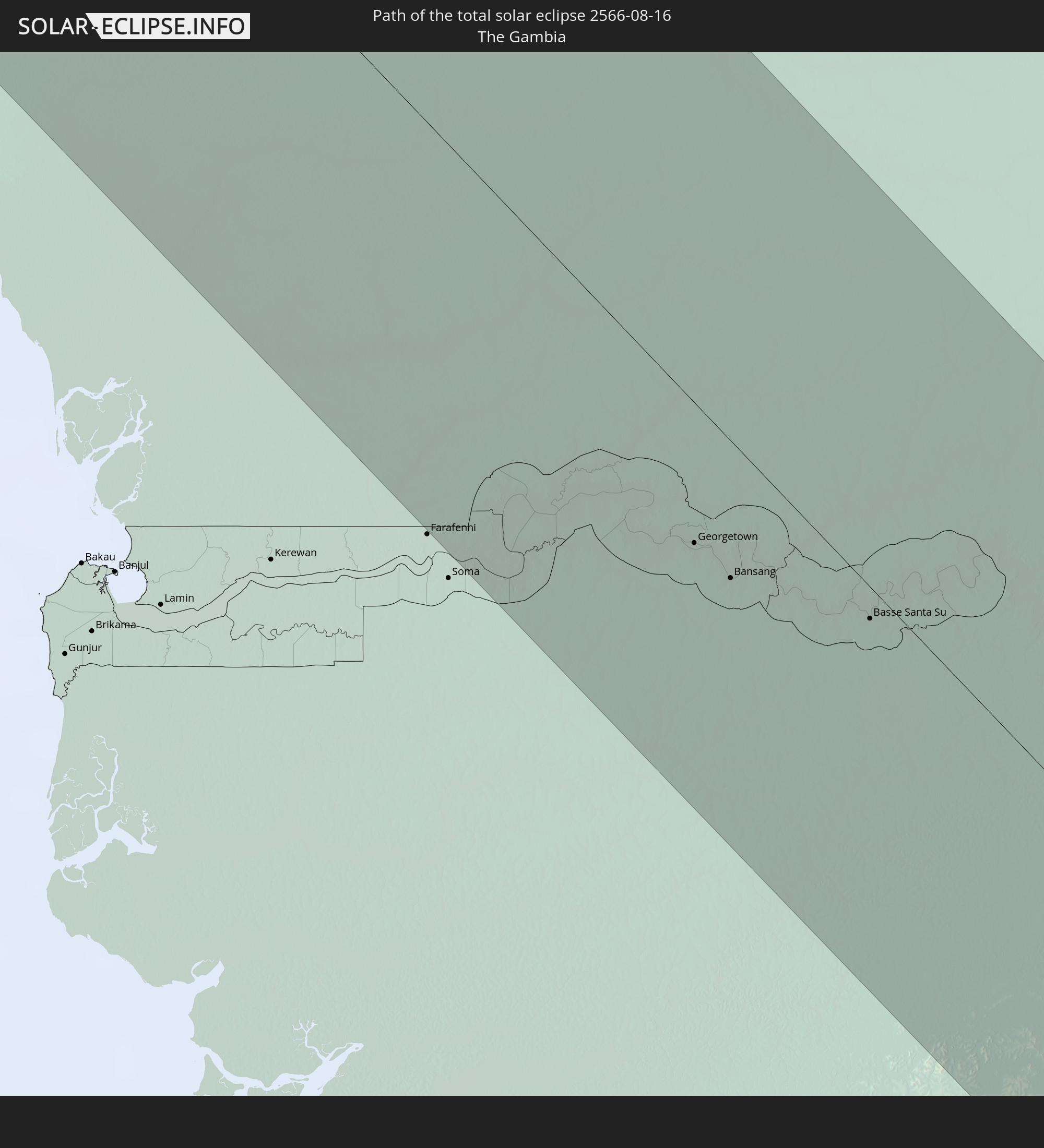 Gambia
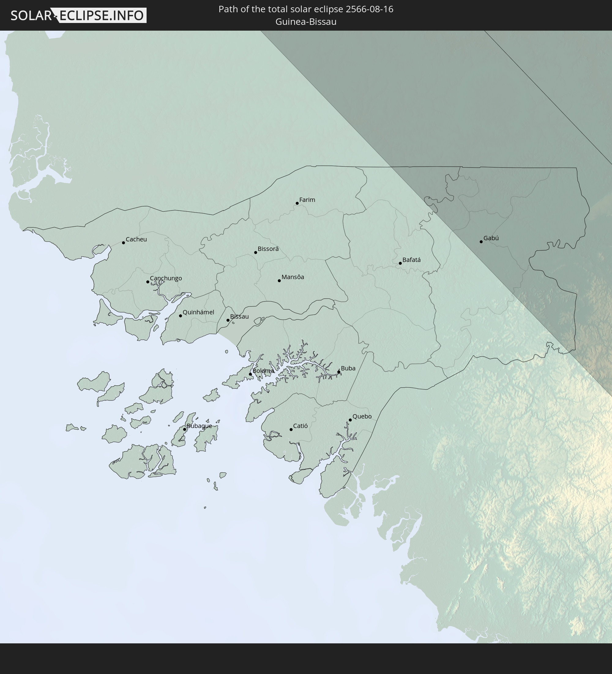 Guinea-Bissau
 Guinea
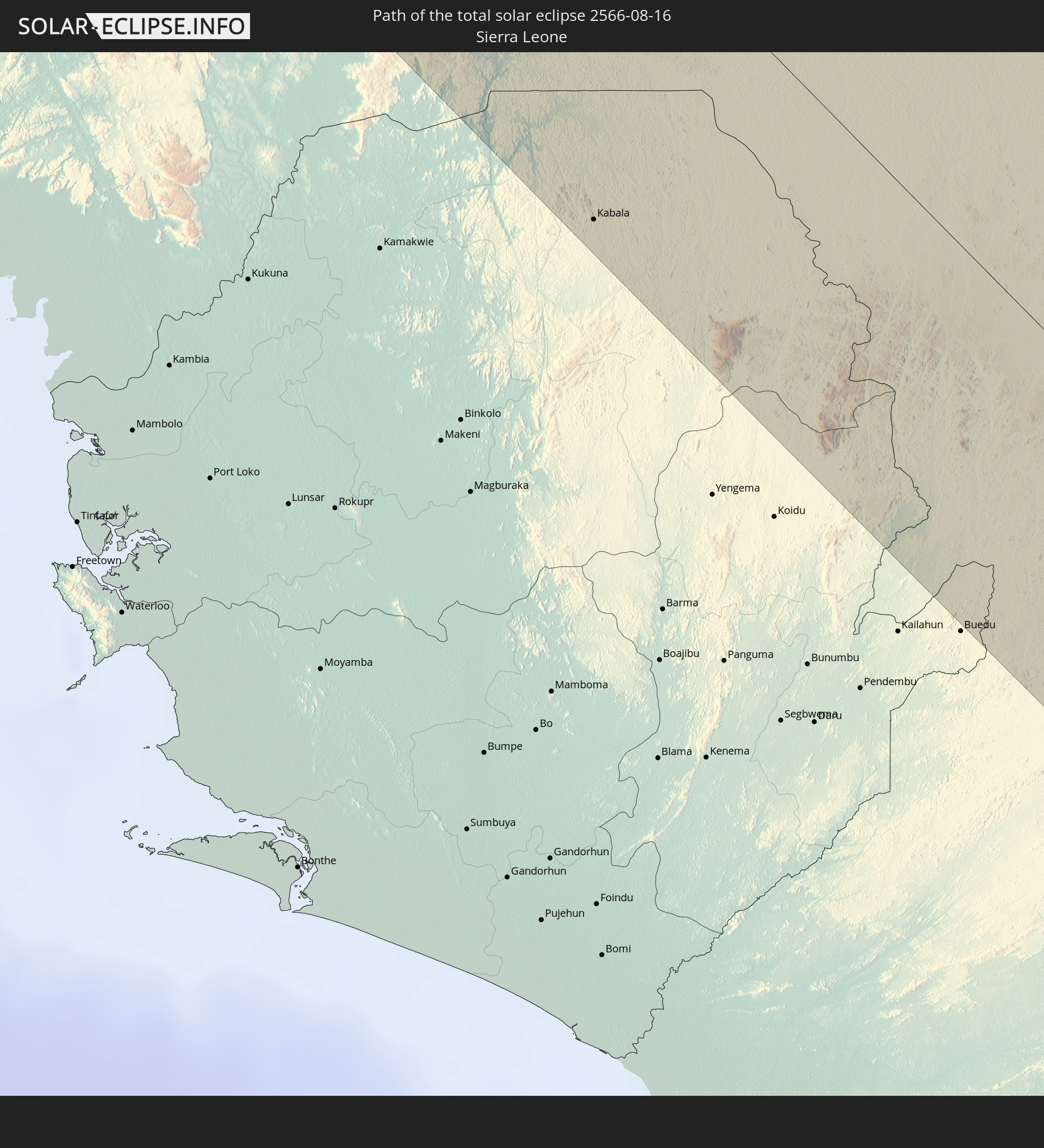 Sierra Leone
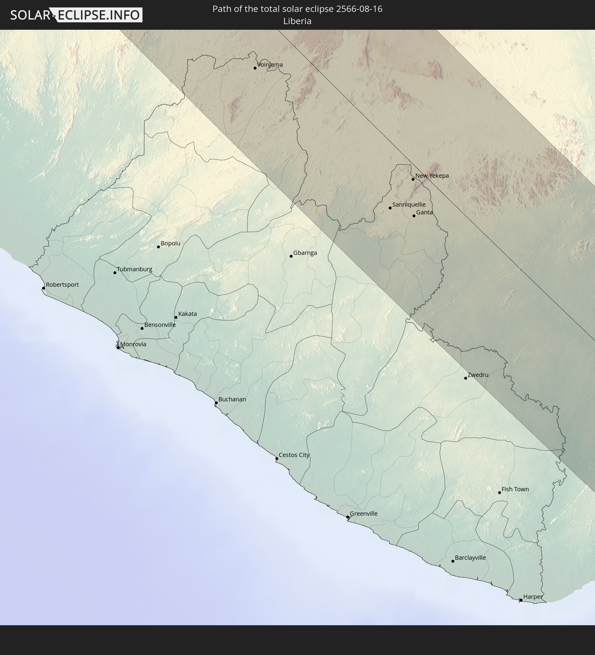 Liberia
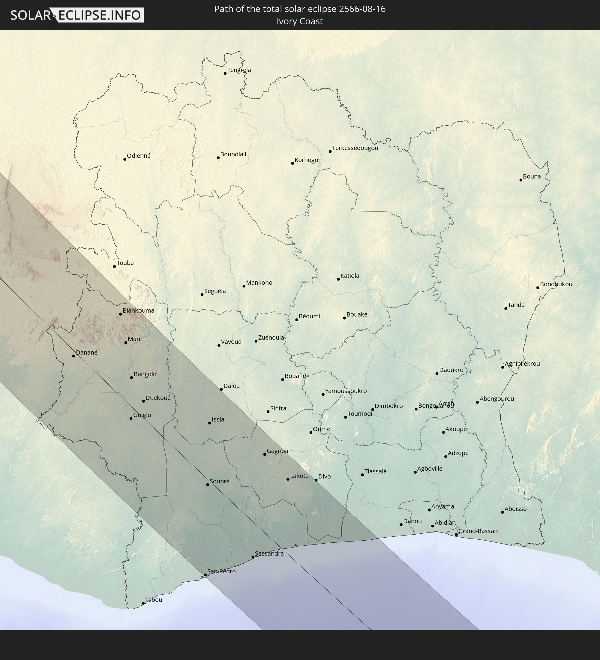 Elfenbeinküste
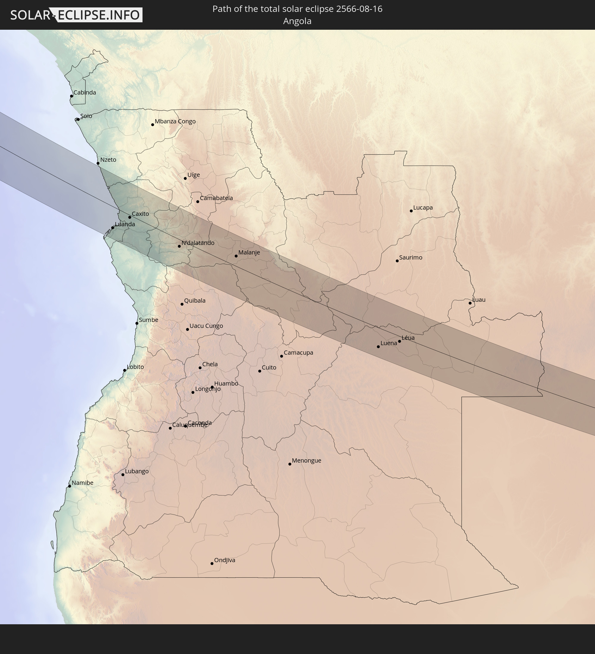 Angola
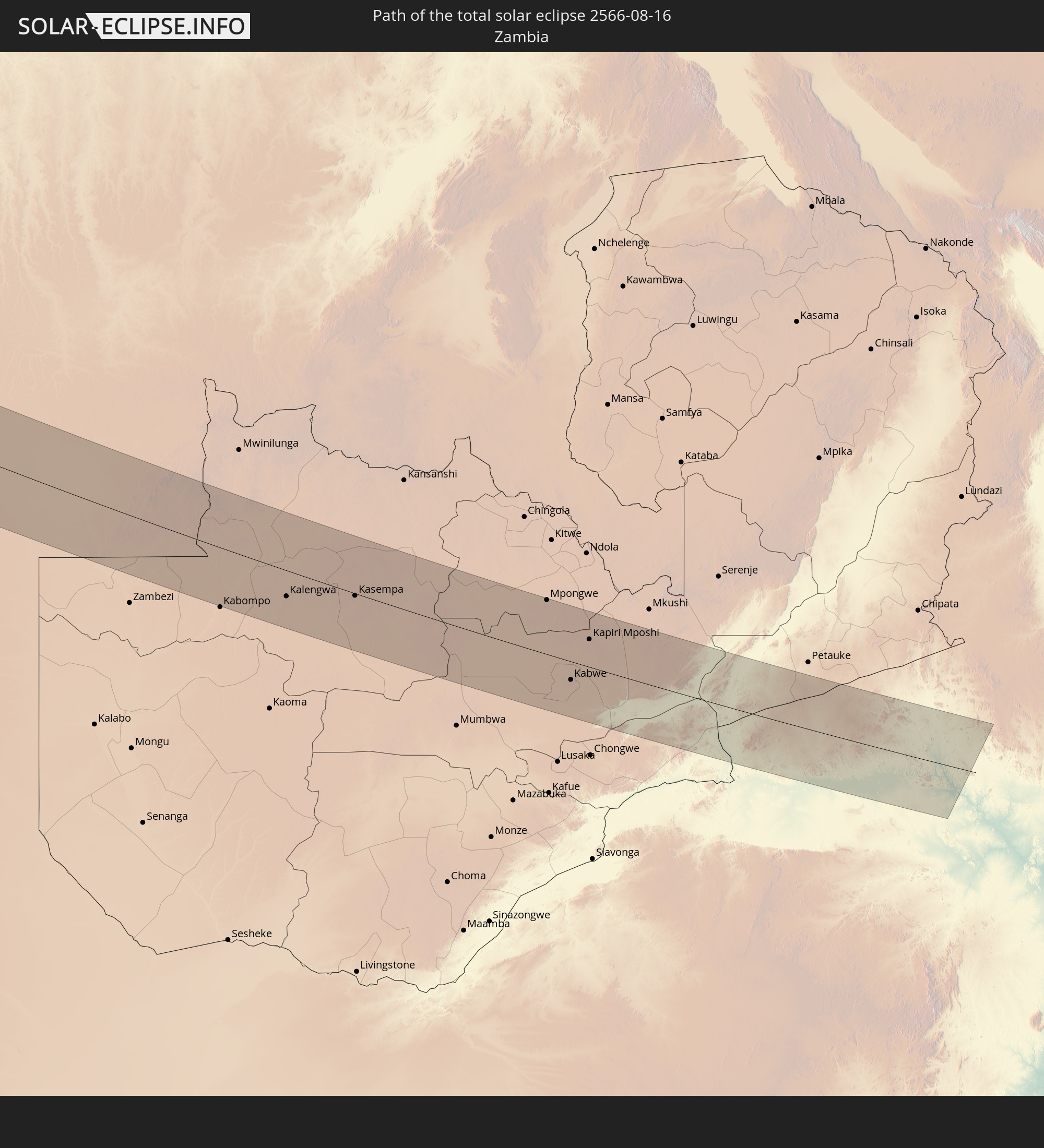 Sambia
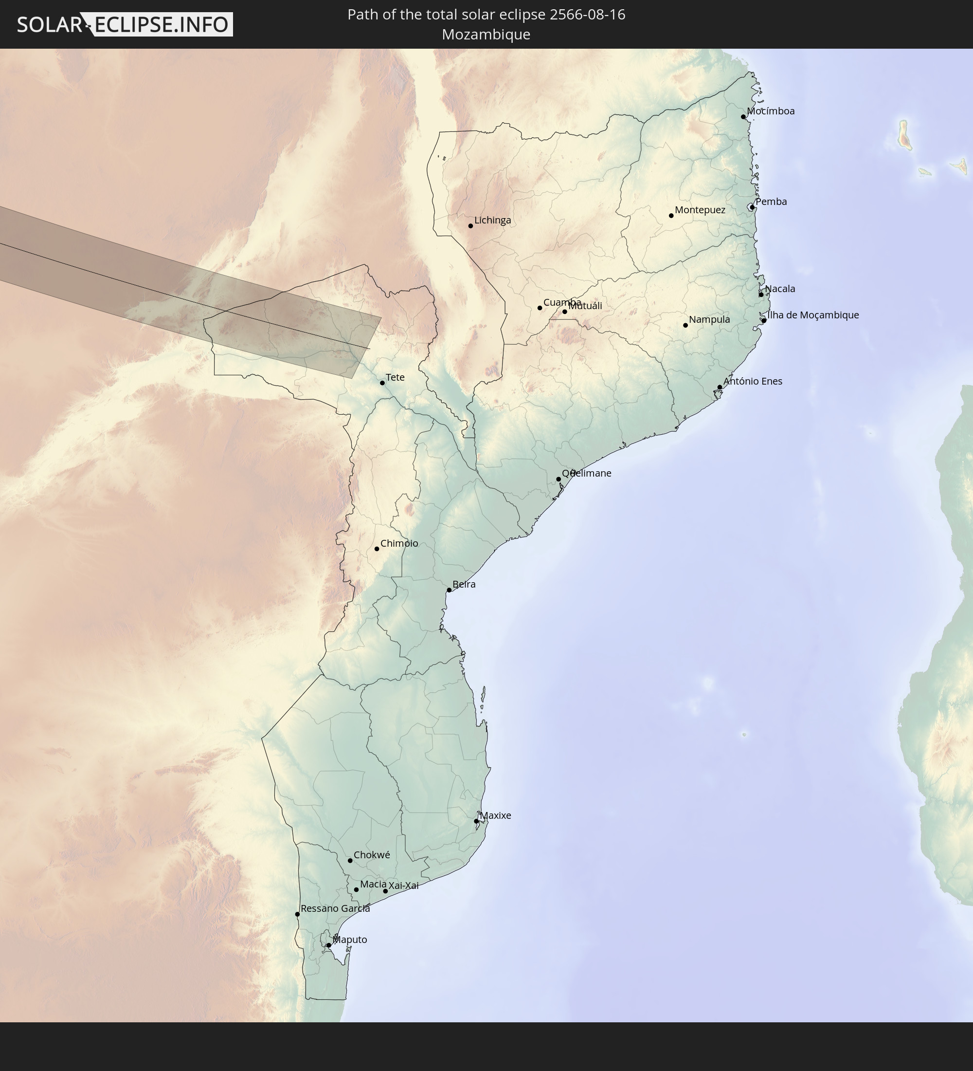 Mosambik
In den folgenden Ländern ist die Sonnenfinsternis partiell zu sehen
 Vereinigte Staaten
 United States Minor Outlying Islands
 Kanada
 Mexiko
 Grönland
 Guatemala
 El Salvador
 Honduras
 Belize
 Nicaragua
 Costa Rica
 Kuba
Kuba
 Panama
 Kolumbien
 Kaimaninseln
 Bahamas
 Jamaika
 Haiti
Haiti
 Brasilien
 Venezuela
 Turks- und Caicosinseln
 Dominikanische Republik
 Aruba
Aruba
 Puerto Rico
 Amerikanische Jungferninseln
 Bermuda
 Britische Jungferninseln
 Anguilla
 Saint-Martin
 Saint-Barthélemy
 St. Kitts und Nevis
 Antigua und Barbuda
 Montserrat
 Trinidad und Tobago
 Guadeloupe
 Grenada
 Dominica
 St. Vincent und die Grenadinen
 Guyana
 Martinique
 St. Lucia
 Barbados
 Suriname
 Saint-Pierre und Miquelon
 Französisch-Guayana
 Portugal
 Kap Verde
 Island
 Spanien
 Senegal
 Mauretanien
 Gambia
 Guinea-Bissau
 Guinea
 St. Helena
 Sierra Leone
 Marokko
 Mali
Mali
 Liberia
 Irland
 Algerien
 Vereinigtes Königreich
 Elfenbeinküste
 Burkina Faso
 Gibraltar
 Frankreich
 Isle of Man
 Ghana
Ghana
 Guernsey
 Jersey
 Togo
Togo
 Niger
Niger
 Benin
Benin
 Andorra
 Nigeria
 Äquatorialguinea
 Schweiz
 São Tomé und Príncipe
 Italien
 Monaco
 Tunesien
 Kamerun
 Gabun
Gabun
 Libyen
 Republik Kongo
 Angola
 Namibia
 Demokratische Republik Kongo
 Tschad
 Malta
Malta
 Zentralafrikanische Republik
 Südafrika
 Botswana
 Sudan
Sudan
 Sambia
 Ägypten
 Simbabwe
 Lesotho
 Ruanda
 Burundi
 Tansania
 Uganda
 Mosambik
 Malawi
 Äthiopien
 Kenia
Kenia
 Saudi-Arabien
 Eritrea
 Somalia
 Dschibuti
 Jemen
Jemen
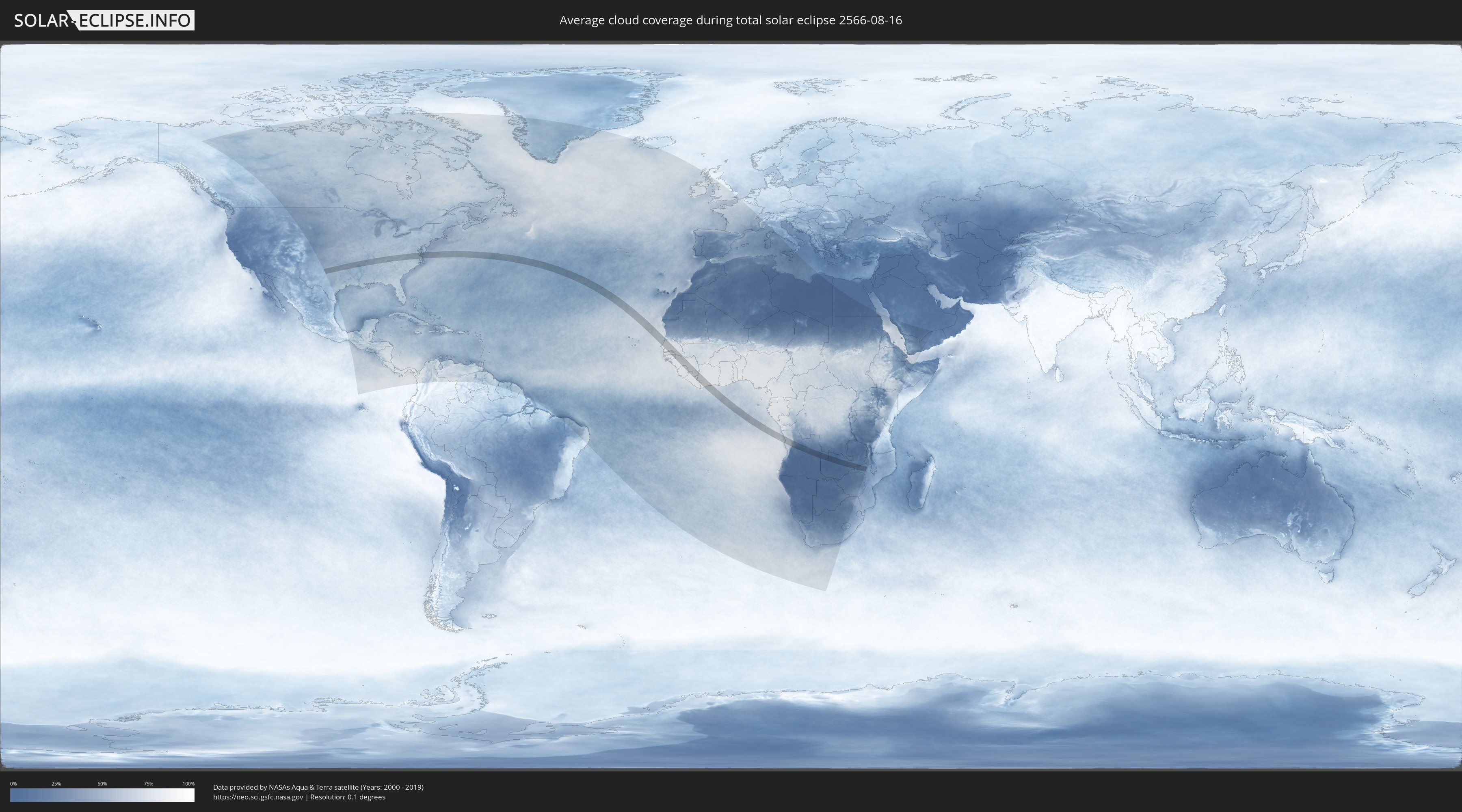
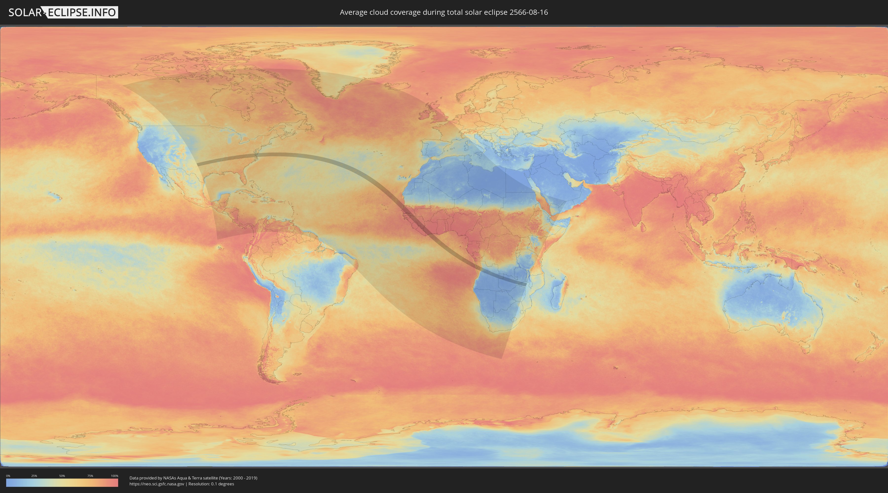
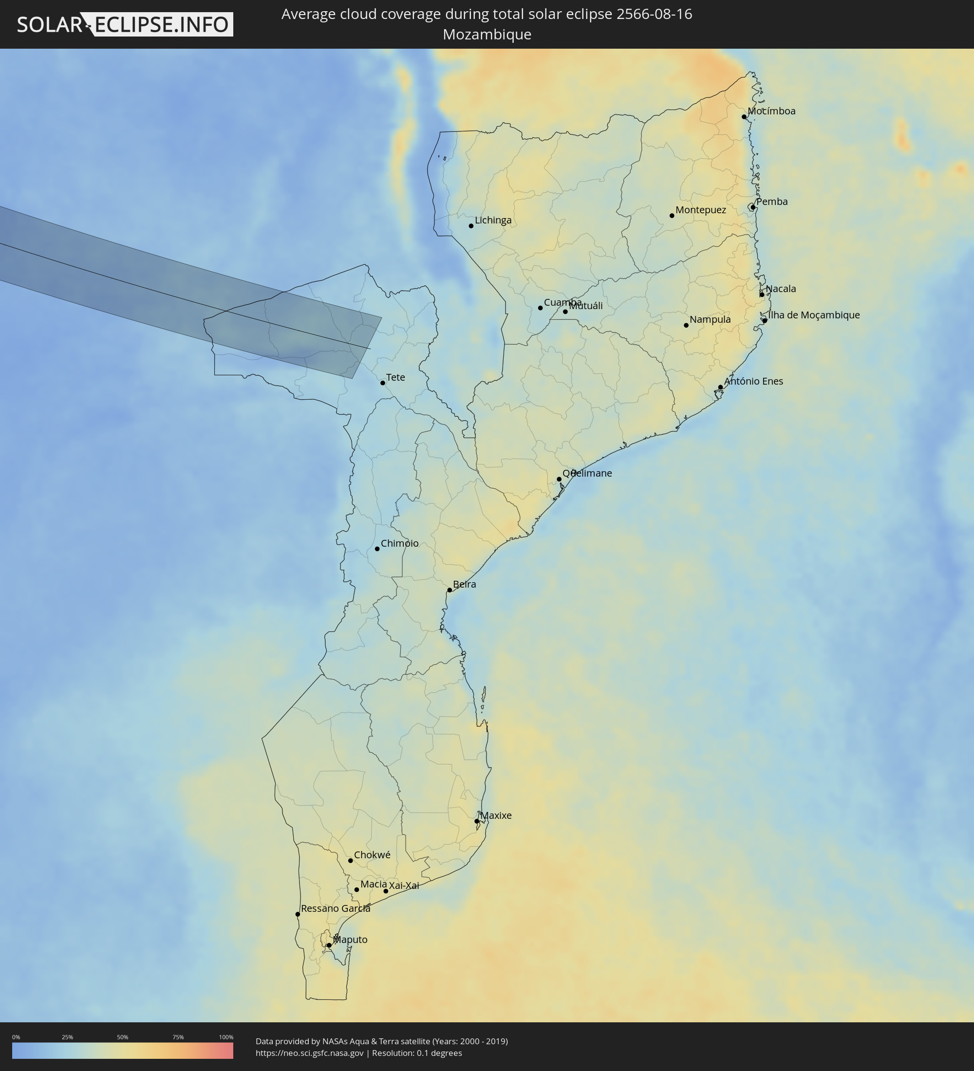
Wie wird das Wetter während der totalen Sonnenfinsternis am 16.08.2566?
Wo ist der beste Ort, um die totale Sonnenfinsternis vom 16.08.2566 zu beobachten?
Die folgenden Karten zeigen die durchschnittliche Bewölkung für den Tag, an dem die totale Sonnenfinsternis
stattfindet. Mit Hilfe der Karten lässt sich der Ort entlang des Finsternispfades eingrenzen,
der die besten Aussichen auf einen klaren wolkenfreien Himmel bietet.
Trotzdem muss man immer lokale Gegenenheiten beachten und sollte sich genau über das Wetter an seinem
gewählten Beobachtungsort informieren.
Die Daten stammen von den beiden NASA-Satelliten
AQUA und TERRA
und wurden über einen Zeitraum von 19 Jahren (2000 - 2019) gemittelt.
Detaillierte Länderkarten
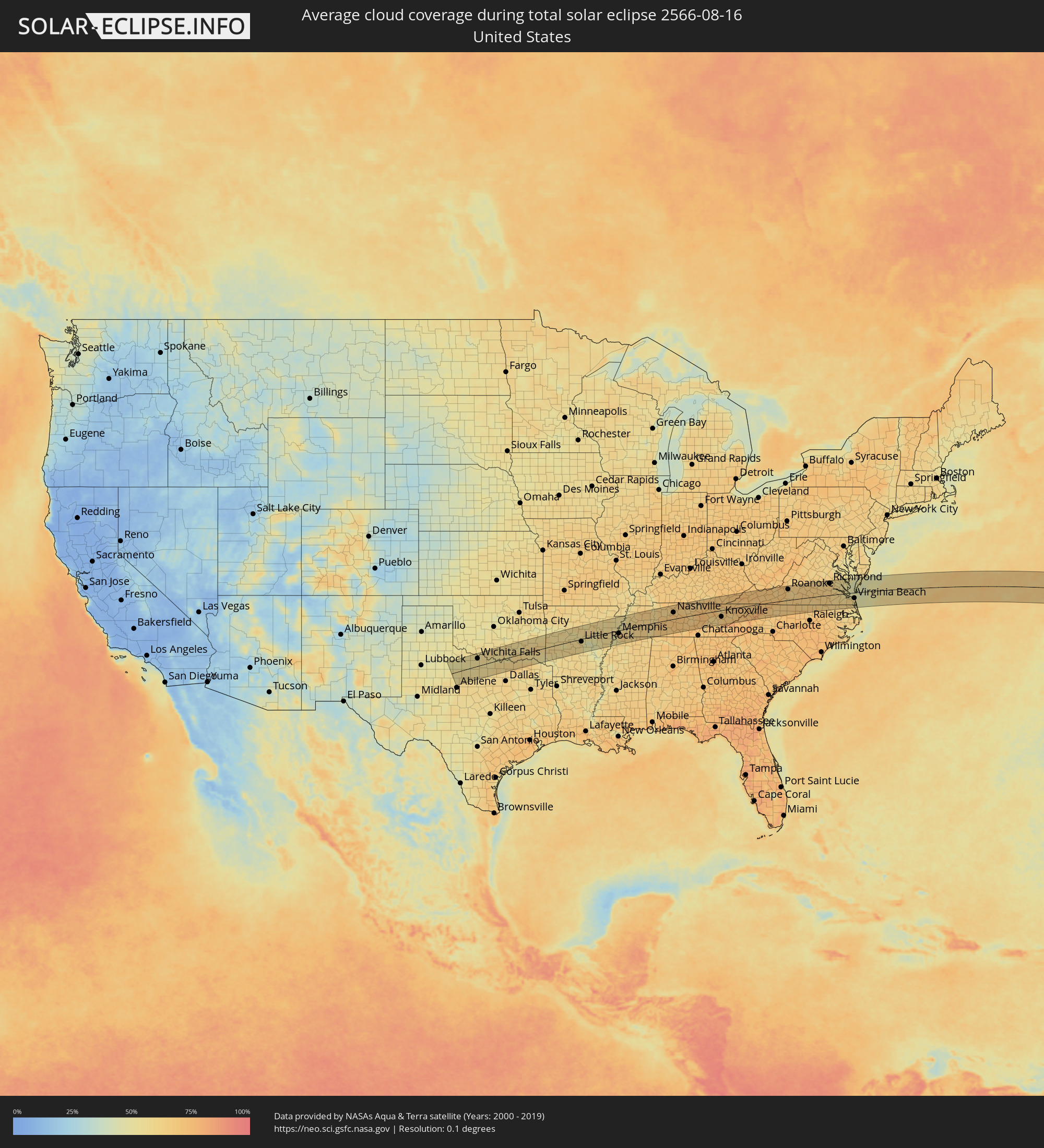 Vereinigte Staaten
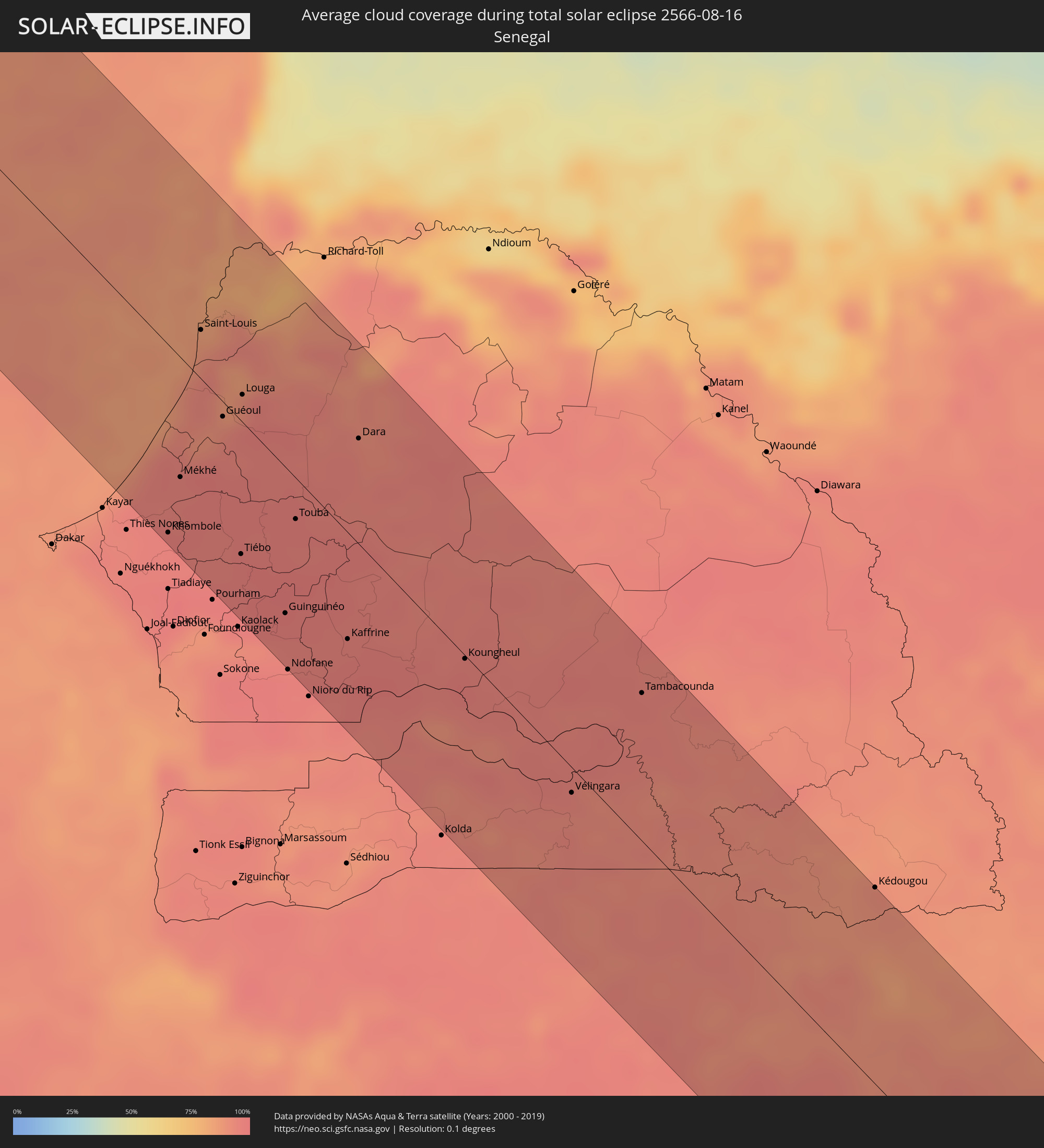 Senegal
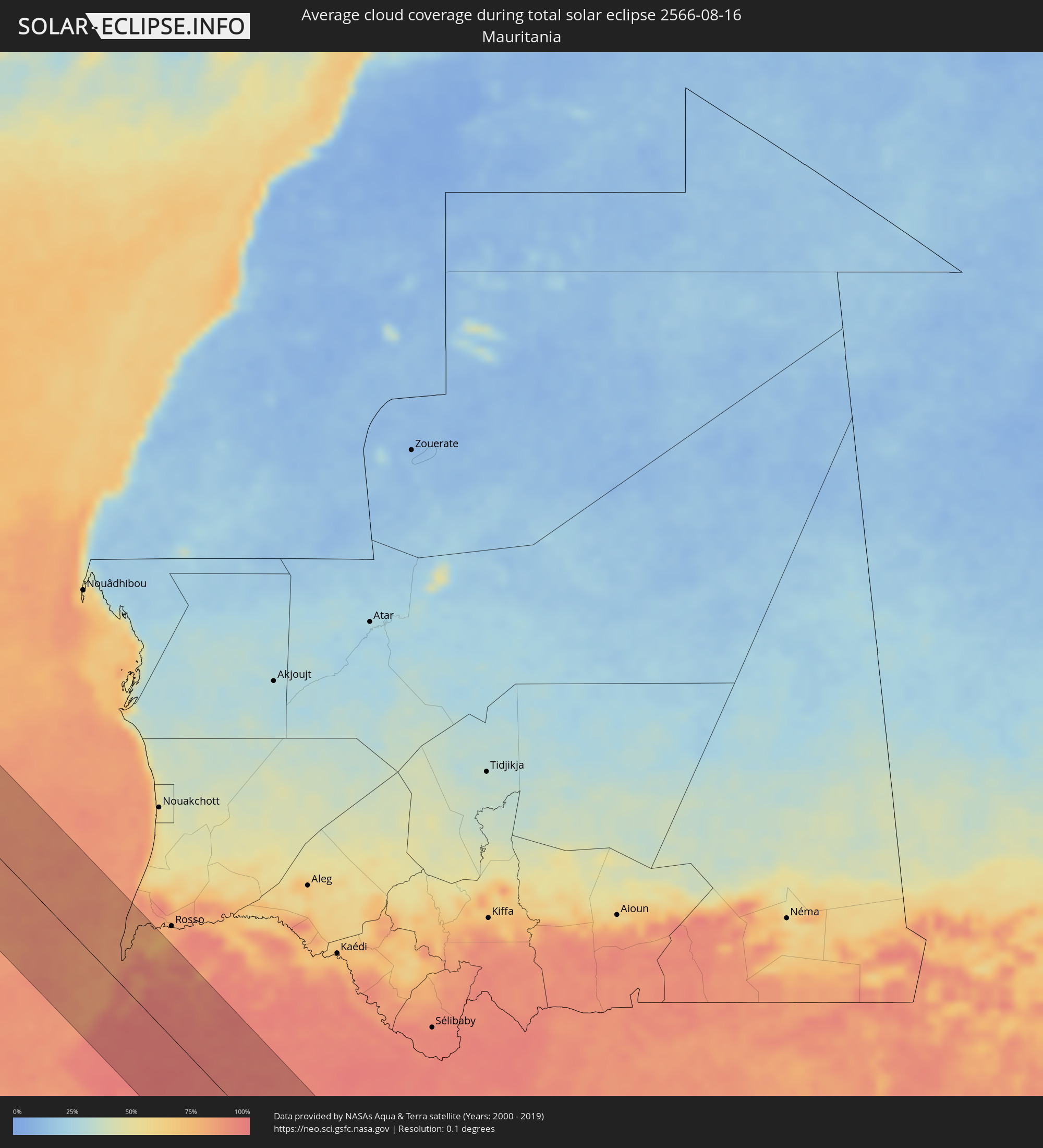 Mauretanien
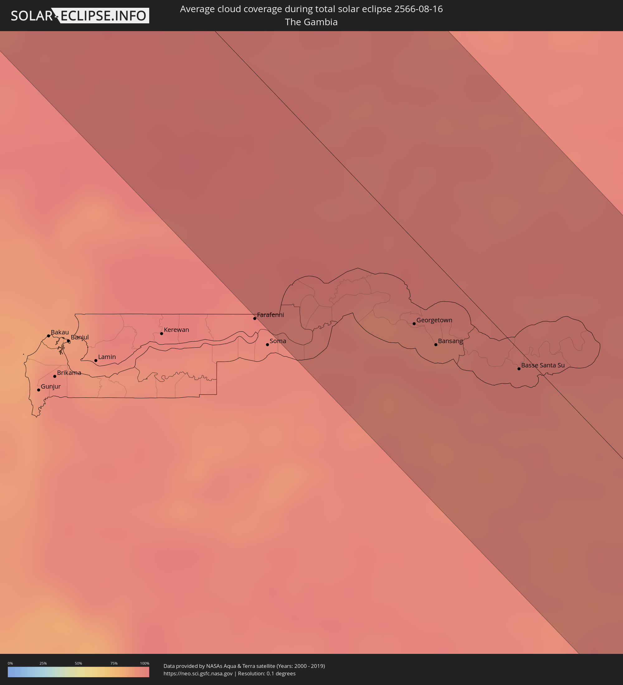 Gambia
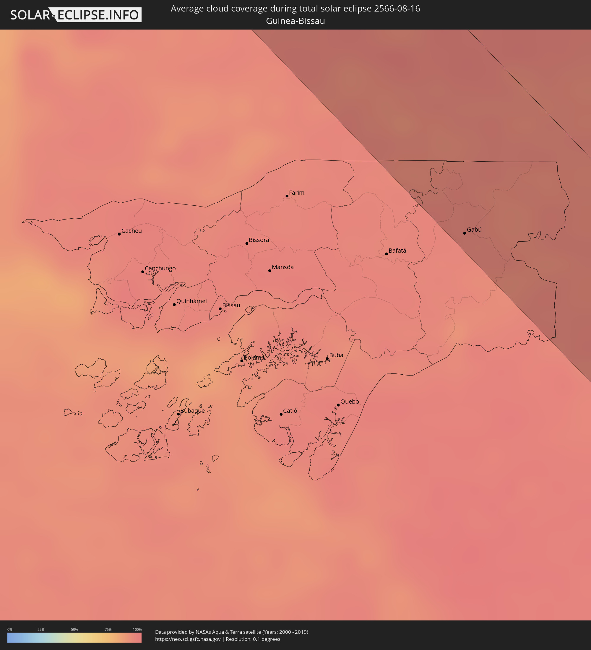 Guinea-Bissau
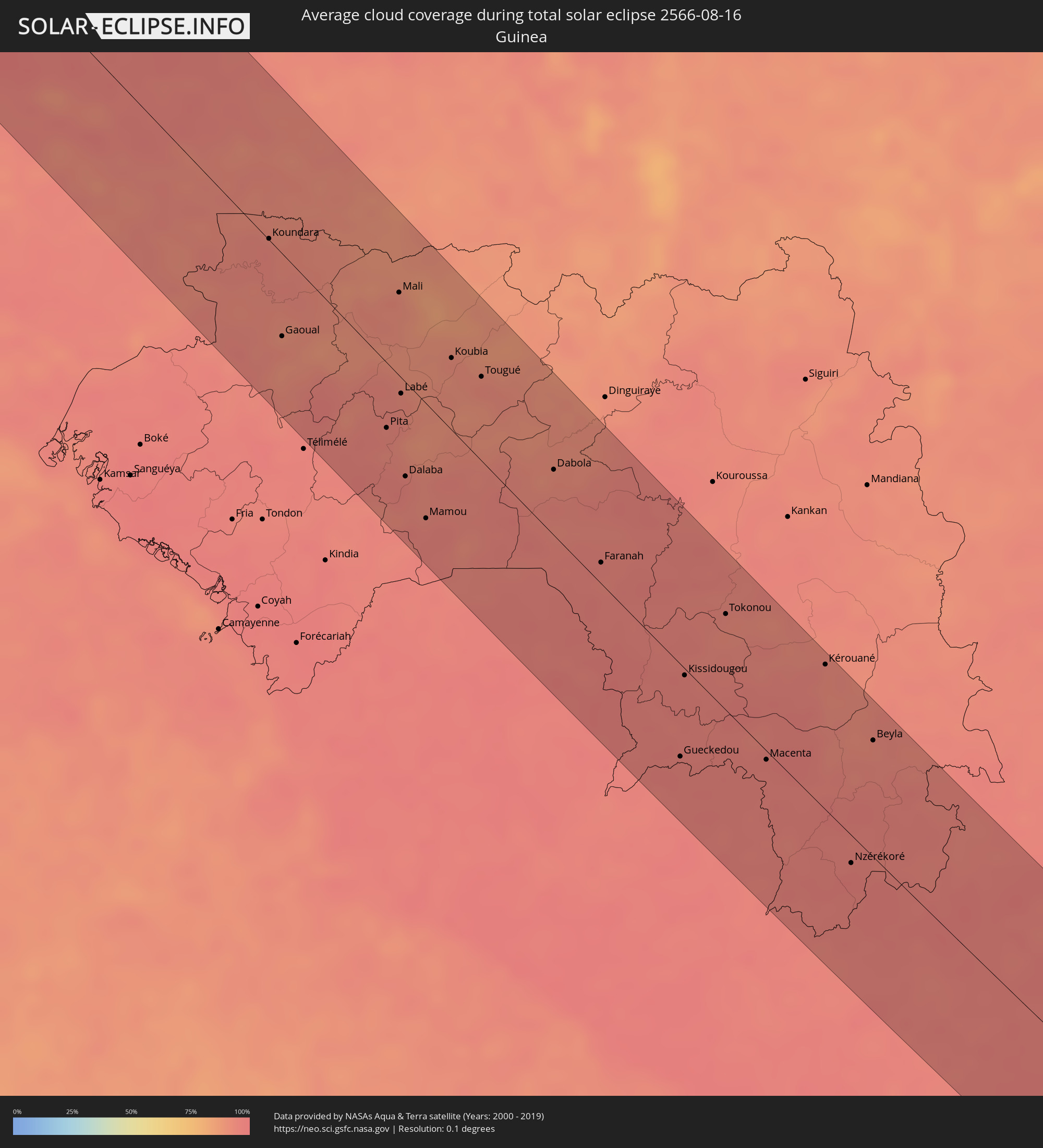 Guinea
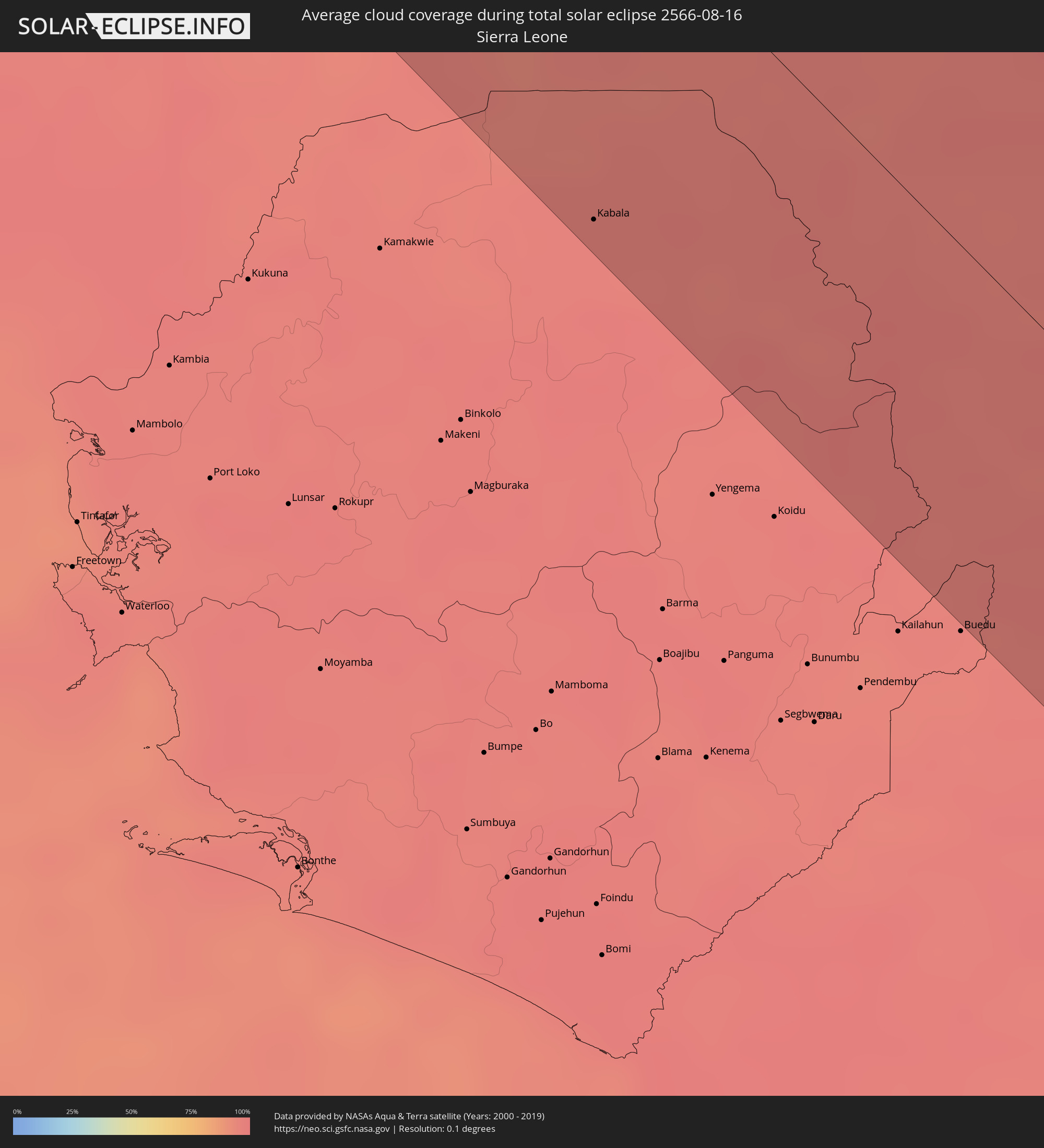 Sierra Leone
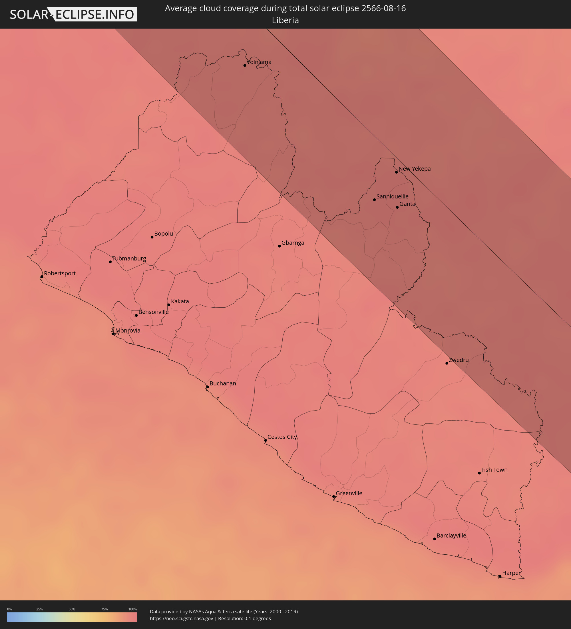 Liberia
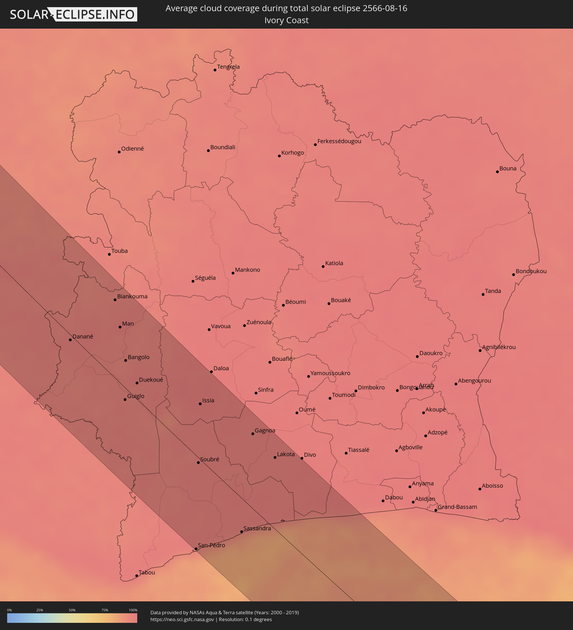 Elfenbeinküste
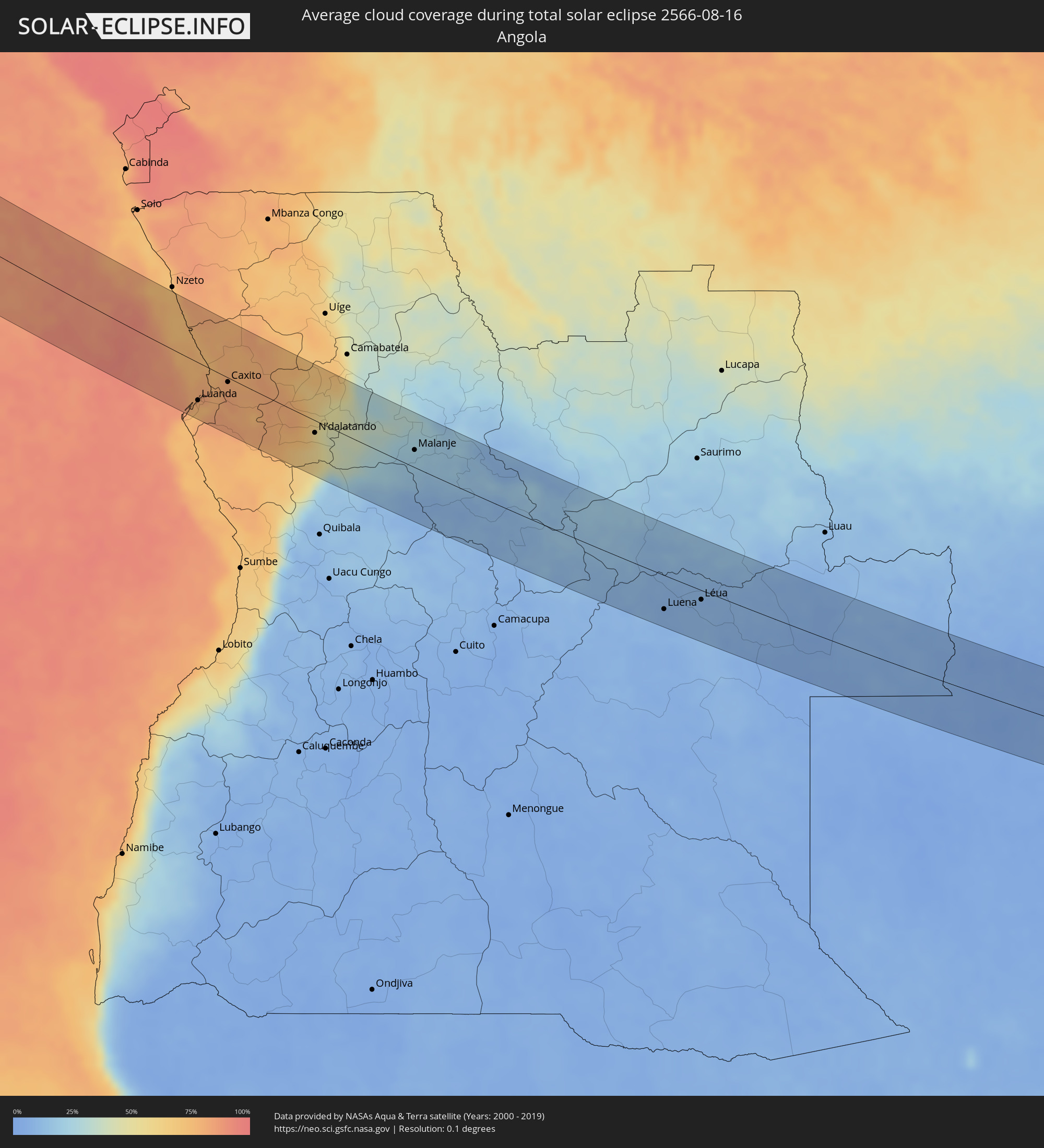 Angola
 Sambia
 Mosambik
Orte im Finsternispfad
Die nachfolgene Tabelle zeigt Städte und Orte mit mehr als 5.000 Einwohnern, die sich im Finsternispfad befinden. Städte mit mehr als 100.000 Einwohnern sind dick gekennzeichnet. Mit einem Klick auf den Ort öffnet sich eine Detailkarte die die Lage des jeweiligen Ortes zusammen mit dem Verlauf der zentralen Finsternis präsentiert.
| Ort | Typ | Dauer der Verfinsterung | Ortszeit bei maximaler Verfinsterung | Entfernung zur Zentrallinie | Ø Bewölkung |
|
Wichita Falls, Texas
|
total | - | 06:09:49 UTC-06:00 | 40 km | 52% |
|
Denton, Texas
|
total | - | 06:09:25 UTC-06:00 | 69 km | 57% |
|
Conway, Arkansas
|
total | - | 06:10:27 UTC-06:00 | 26 km | 53% |
|
Little Rock, Arkansas
|
total | - | 06:10:18 UTC-06:00 | 14 km | 59% |
|
Jonesboro, Arkansas
|
total | - | 06:11:02 UTC-06:00 | 72 km | 60% |
|
Memphis, Tennessee
|
total | - | 06:10:47 UTC-06:00 | 16 km | 65% |
|
Jackson, Tennessee
|
total | - | 06:11:15 UTC-06:00 | 11 km | 63% |
|
Franklin, Tennessee
|
total | - | 06:11:50 UTC-06:00 | 10 km | 71% |
|
Nashville, Tennessee
|
total | - | 06:11:59 UTC-06:00 | 34 km | 71% |
|
Murfreesboro, Tennessee
|
total | - | 06:11:55 UTC-06:00 | 7 km | 70% |
|
Knoxville, Tennessee
|
total | - | 07:12:44 UTC-05:00 | 34 km | 67% |
|
Johnson City, Tennessee
|
total | - | 07:13:29 UTC-05:00 | 18 km | 71% |
|
Winston-Salem, North Carolina
|
total | - | 07:14:17 UTC-05:00 | 69 km | 71% |
|
Roanoke, Virginia
|
total | - | 07:15:00 UTC-05:00 | 56 km | 66% |
|
Lynchburg, Virginia
|
total | - | 07:15:27 UTC-05:00 | 63 km | 66% |
|
Richmond, Virginia
|
total | - | 07:16:23 UTC-05:00 | 61 km | 67% |
|
Suffolk, Virginia
|
total | - | 07:16:29 UTC-05:00 | 38 km | 61% |
|
Newport News, Virginia
|
total | - | 07:16:43 UTC-05:00 | 0 km | 54% |
|
Norfolk, Virginia
|
total | - | 07:16:43 UTC-05:00 | 28 km | 65% |
|
Virginia Beach, Virginia
|
total | - | 07:16:54 UTC-05:00 | 29 km | 55% |
|
Khombole, Thiès
|
total | - | 14:18:25 UTC+00:00 | 89 km | 96% |
|
Mékhé, Thiès
|
total | - | 14:17:52 UTC+00:00 | 57 km | 96% |
|
Saint-Louis, Saint-Louis
|
total | - | 14:16:15 UTC+00:00 | 23 km | 87% |
|
Guéoul, Louga
|
total | - | 14:17:35 UTC+00:00 | 7 km | 91% |
|
Diourbel, Diourbel
|
total | - | 14:19:28 UTC+00:00 | 63 km | 97% |
|
Tiébo, Diourbel
|
total | - | 14:19:30 UTC+00:00 | 63 km | 97% |
|
Louga, Louga
|
total | - | 14:17:32 UTC+00:00 | 13 km | 96% |
|
Guinguinéo, Fatick
|
total | - | 14:20:44 UTC+00:00 | 70 km | 97% |
|
Mbaké, Diourbel
|
total | - | 14:19:45 UTC+00:00 | 26 km | 97% |
|
Touba, Diourbel
|
total | - | 14:19:40 UTC+00:00 | 20 km | 96% |
|
Kaffrine, Kaffrine
|
total | - | 14:21:45 UTC+00:00 | 51 km | 96% |
|
Dara, Louga
|
total | - | 14:19:22 UTC+00:00 | 50 km | 95% |
|
Ndibène Dahra, Louga
|
total | - | 14:19:24 UTC+00:00 | 49 km | 95% |
|
Koungheul, Kaffrine
|
total | - | 14:23:16 UTC+00:00 | 2 km | 97% |
|
Georgetown, Central River
|
total | - | 14:24:13 UTC+00:00 | 33 km | 95% |
|
Bansang, Central River
|
total | - | 14:24:38 UTC+00:00 | 32 km | 96% |
|
Gabú, Gabú
|
total | - | 14:27:39 UTC+00:00 | 87 km | 94% |
|
Basse Santa Su, Upper River
|
total | - | 14:25:36 UTC+00:00 | 7 km | 96% |
|
Sabi, Upper River
|
total | - | 14:25:47 UTC+00:00 | 12 km | 94% |
|
Vélingara, Kolda
|
total | - | 14:26:05 UTC+00:00 | 12 km | 95% |
|
Tambacounda, Tambacounda
|
total | - | 14:25:35 UTC+00:00 | 71 km | 96% |
|
Koundara, Boke
|
total | - | 14:28:45 UTC+00:00 | 1 km | 95% |
|
Gaoual, Boke
|
total | - | 14:30:23 UTC+00:00 | 48 km | 93% |
|
Youkounkoun, Boke
|
total | - | 14:28:57 UTC+00:00 | 18 km | 93% |
|
Pita, Mamou
|
total | - | 14:33:02 UTC+00:00 | 38 km | 95% |
|
Mali, Labe
|
total | - | 14:31:10 UTC+00:00 | 48 km | 91% |
|
Labé, Labe
|
total | - | 14:32:42 UTC+00:00 | 9 km | 94% |
|
Dalaba, Mamou
|
total | - | 14:33:59 UTC+00:00 | 55 km | 95% |
|
Kédougou, Kédougou
|
total | - | 14:30:25 UTC+00:00 | 95 km | 90% |
|
Mamou, Mamou
|
total | - | 14:34:51 UTC+00:00 | 67 km | 95% |
|
Koubia, Labe
|
total | - | 14:32:46 UTC+00:00 | 42 km | 90% |
|
Tougué, Labe
|
total | - | 14:33:25 UTC+00:00 | 49 km | 90% |
|
Kabala, Northern Province
|
total | - | 14:37:13 UTC+00:00 | 86 km | 96% |
|
Dabola, Faranah
|
total | - | 14:35:39 UTC+00:00 | 39 km | 93% |
|
Faranah, Faranah
|
total | - | 14:37:34 UTC+00:00 | 13 km | 94% |
|
Gueckedou, Nzerekore
|
total | - | 14:41:18 UTC+00:00 | 55 km | 96% |
|
Kissidougou, Faranah
|
total | - | 14:40:10 UTC+00:00 | 4 km | 96% |
|
Tokonou, Kankan
|
total | - | 14:39:45 UTC+00:00 | 57 km | 94% |
|
Voinjama, Lofa
|
total | - | 14:42:08 UTC+00:00 | 36 km | 96% |
|
Macenta, Nzerekore
|
total | - | 14:42:19 UTC+00:00 | 5 km | 95% |
|
Kérouané, Kankan
|
total | - | 14:41:36 UTC+00:00 | 87 km | 93% |
|
Nzérékoré, Nzerekore
|
total | - | 14:44:44 UTC+00:00 | 17 km | 96% |
|
Sanniquellie, Nimba
|
total | - | 14:45:36 UTC+00:00 | 40 km | 97% |
|
Beyla, Nzerekore
|
total | - | 14:43:13 UTC+00:00 | 70 km | 93% |
|
New Yekepa, Nimba
|
total | - | 14:45:27 UTC+00:00 | 9 km | 97% |
|
Ganta, Nimba
|
total | - | 14:45:58 UTC+00:00 | 31 km | 96% |
|
Toulépleu Gueré, Montagnes
|
total | - | 14:47:28 UTC+00:00 | 81 km | 96% |
|
Danané, Montagnes
|
total | - | 14:46:35 UTC+00:00 | 5 km | 97% |
|
Biankouma, Montagnes
|
total | - | 14:46:26 UTC+00:00 | 75 km | 96% |
|
Man, Montagnes
|
total | - | 14:47:07 UTC+00:00 | 54 km | 95% |
|
Guiglo, Montagnes
|
total | - | 14:48:48 UTC+00:00 | 11 km | 96% |
|
Bangolo, Montagnes
|
total | - | 14:47:57 UTC+00:00 | 27 km | 96% |
|
Duekoué, Montagnes
|
total | - | 14:48:38 UTC+00:00 | 16 km | 96% |
|
San-Pédro, Bas-Sassandra
|
total | - | 14:53:08 UTC+00:00 | 91 km | 84% |
|
Soubré, Bas-Sassandra
|
total | - | 14:51:20 UTC+00:00 | 5 km | 96% |
|
Issia, Sassandra-Marahoué
|
total | - | 14:50:06 UTC+00:00 | 54 km | 97% |
|
Guibéroua, Gôh-Djiboua
|
total | - | 14:51:06 UTC+00:00 | 65 km | 97% |
|
Sassandra, Bas-Sassandra
|
total | - | 14:53:29 UTC+00:00 | 33 km | 90% |
|
Gagnoa, Gôh-Djiboua
|
total | - | 14:51:35 UTC+00:00 | 73 km | 97% |
|
Lakota, Gôh-Djiboua
|
total | - | 14:52:26 UTC+00:00 | 70 km | 97% |
|
Grand-Lahou, Lagunes
|
total | - | 14:54:31 UTC+00:00 | 62 km | 88% |
|
Luanda, Luanda
|
total | - | 16:28:49 UTC+01:00 | 53 km | 76% |
|
Caxito, Bengo
|
total | - | 16:28:47 UTC+01:00 | 6 km | 81% |
|
N’dalatando, Cuanza Norte
|
total | - | 16:29:58 UTC+01:00 | 17 km | 58% |
|
Malanje, Malanje
|
total | - | 16:30:45 UTC+01:00 | 25 km | 20% |
|
Luena, Moxico
|
total | - | 16:33:37 UTC+01:00 | 49 km | 8% |
|
Léua, Moxico
|
total | - | 16:33:39 UTC+01:00 | 14 km | 9% |
|
Mufumbwe, North-Western
|
total | - | 17:35:44 UTC+02:00 | 62 km | 2% |
|
Kalengwa, North-Western
|
total | - | 17:35:37 UTC+02:00 | 32 km | 4% |
|
Kasempa, North-Western
|
total | - | 17:35:42 UTC+02:00 | 3 km | 4% |
|
Mpongwe, Copperbelt
|
total | - | 17:35:51 UTC+02:00 | 68 km | 11% |
|
Kapiri Mposhi, Central
|
total | - | 17:36:07 UTC+02:00 | 35 km | 8% |