Totale Sonnenfinsternis vom 05.05.2600
| Wochentag: | Montag |
| Maximale Dauer der Verfinsterung: | 02m57s |
| Maximale Breite des Finsternispfades: | 579 km |
| Saroszyklus: | 167 |
| Bedeckungsgrad: | 100% |
| Magnitude: | 1.0552 |
| Gamma: | 0.9474 |
Wo kann man die Sonnenfinsternis vom 05.05.2600 sehen?
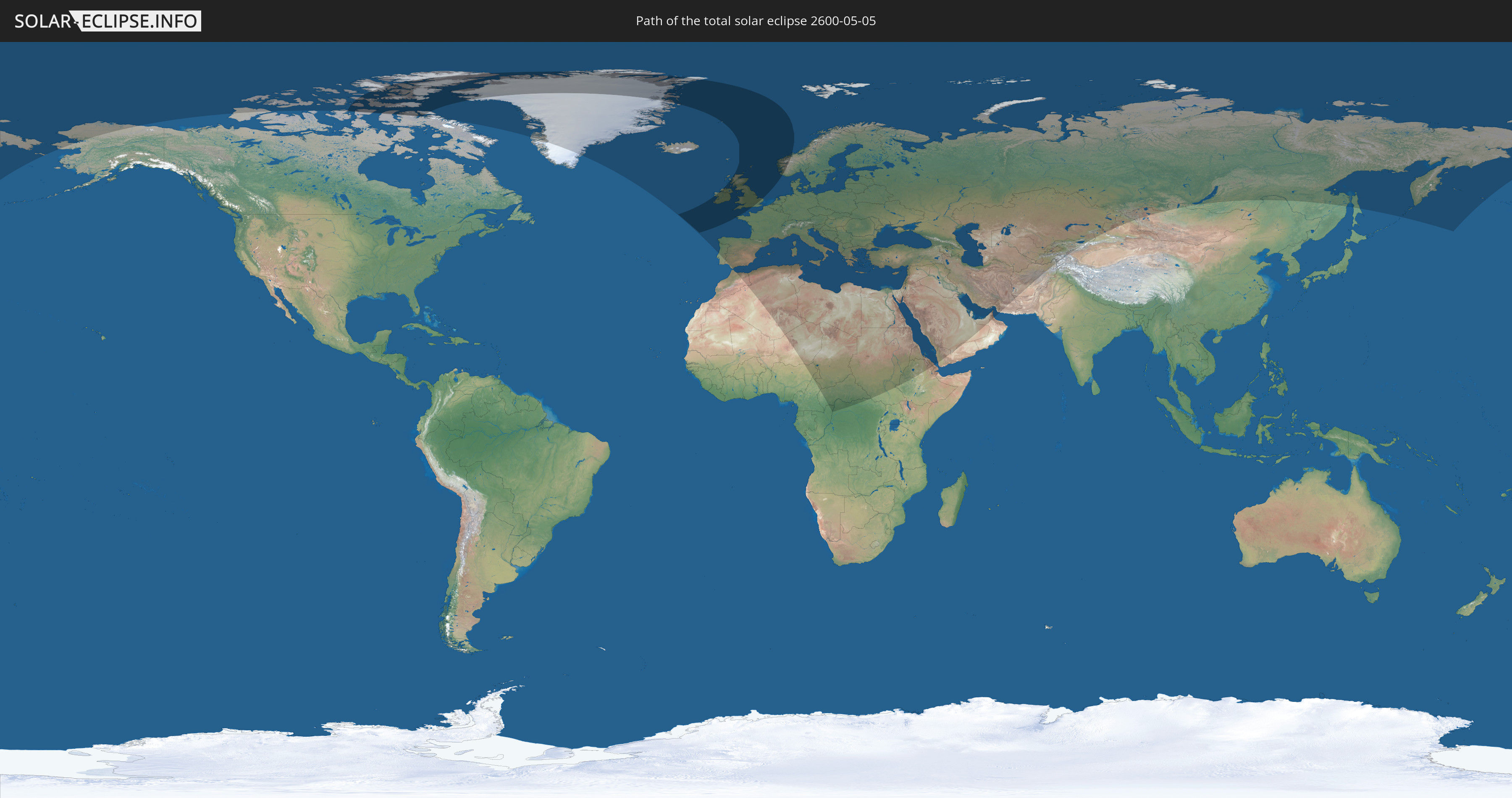
Die Sonnenfinsternis am 05.05.2600 kann man in 97 Ländern als partielle Sonnenfinsternis beobachten.
Der Finsternispfad verläuft durch 8 Länder. Nur in diesen Ländern ist sie als totale Sonnenfinsternis zu sehen.
In den folgenden Ländern ist die Sonnenfinsternis total zu sehen
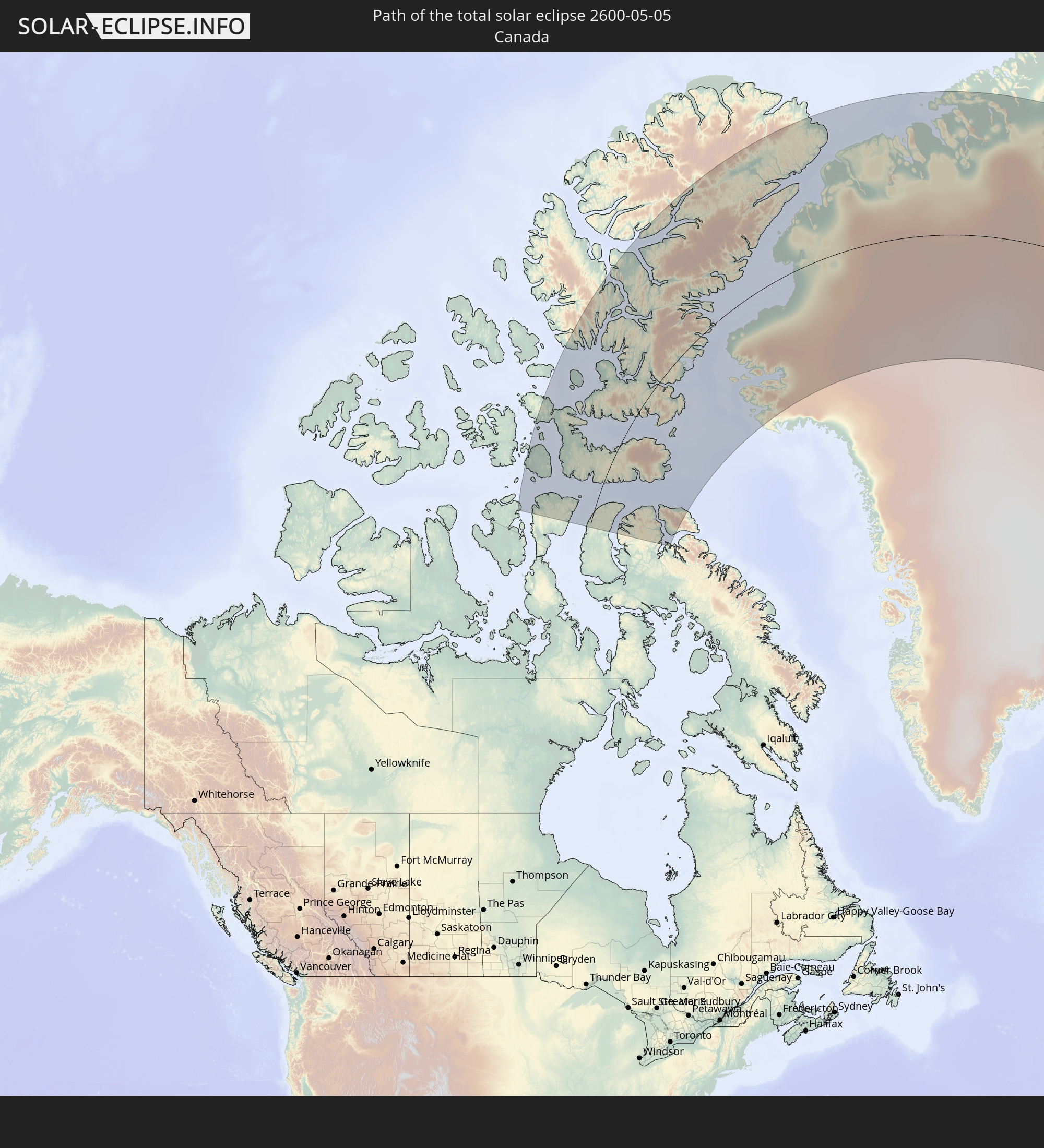 Kanada
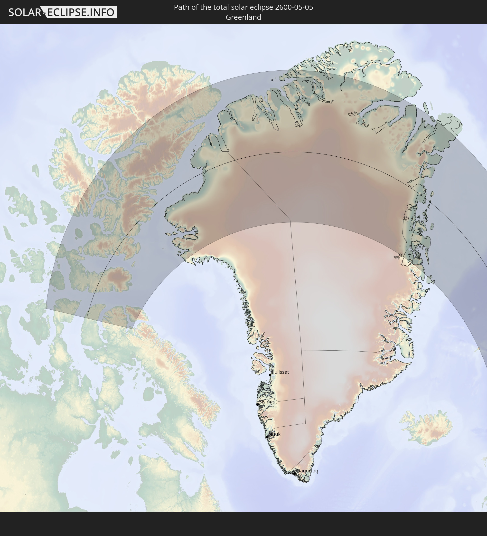 Grönland
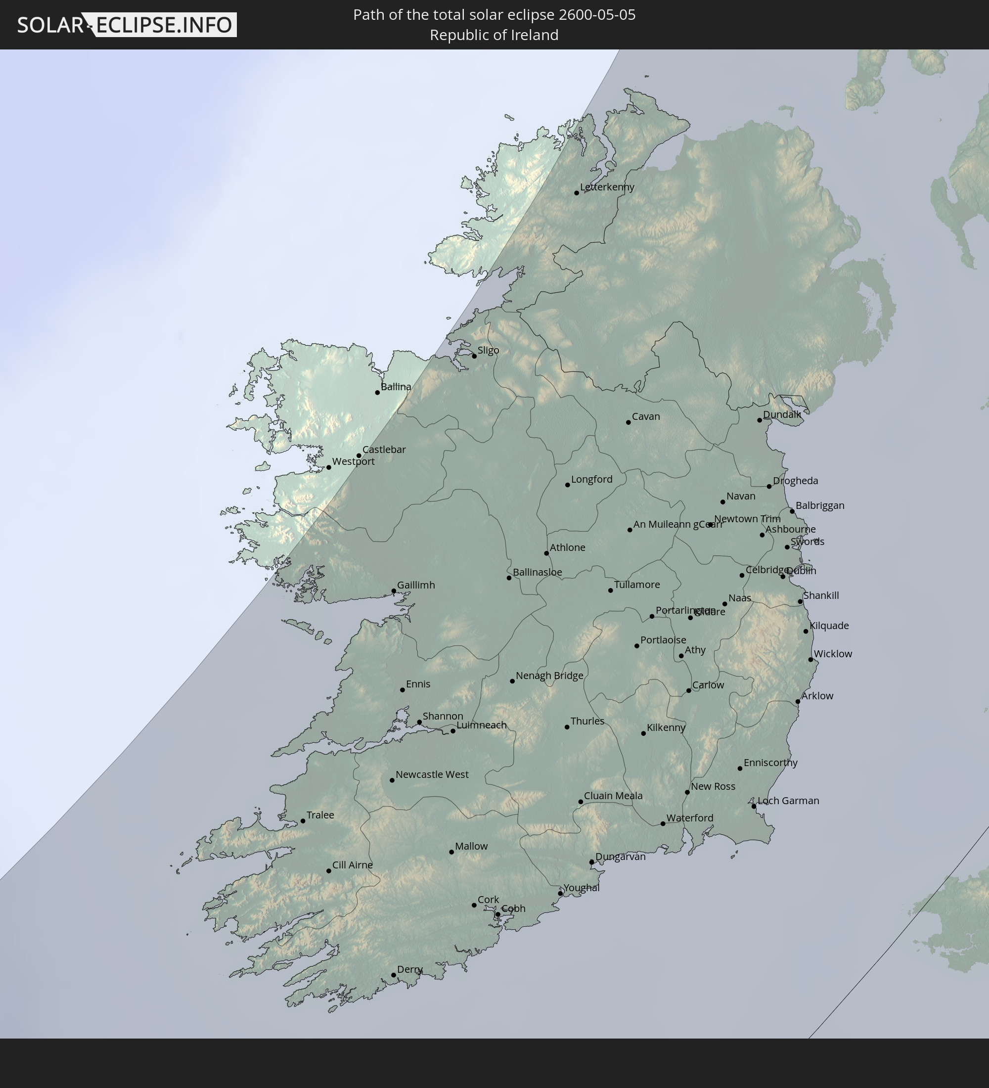 Irland
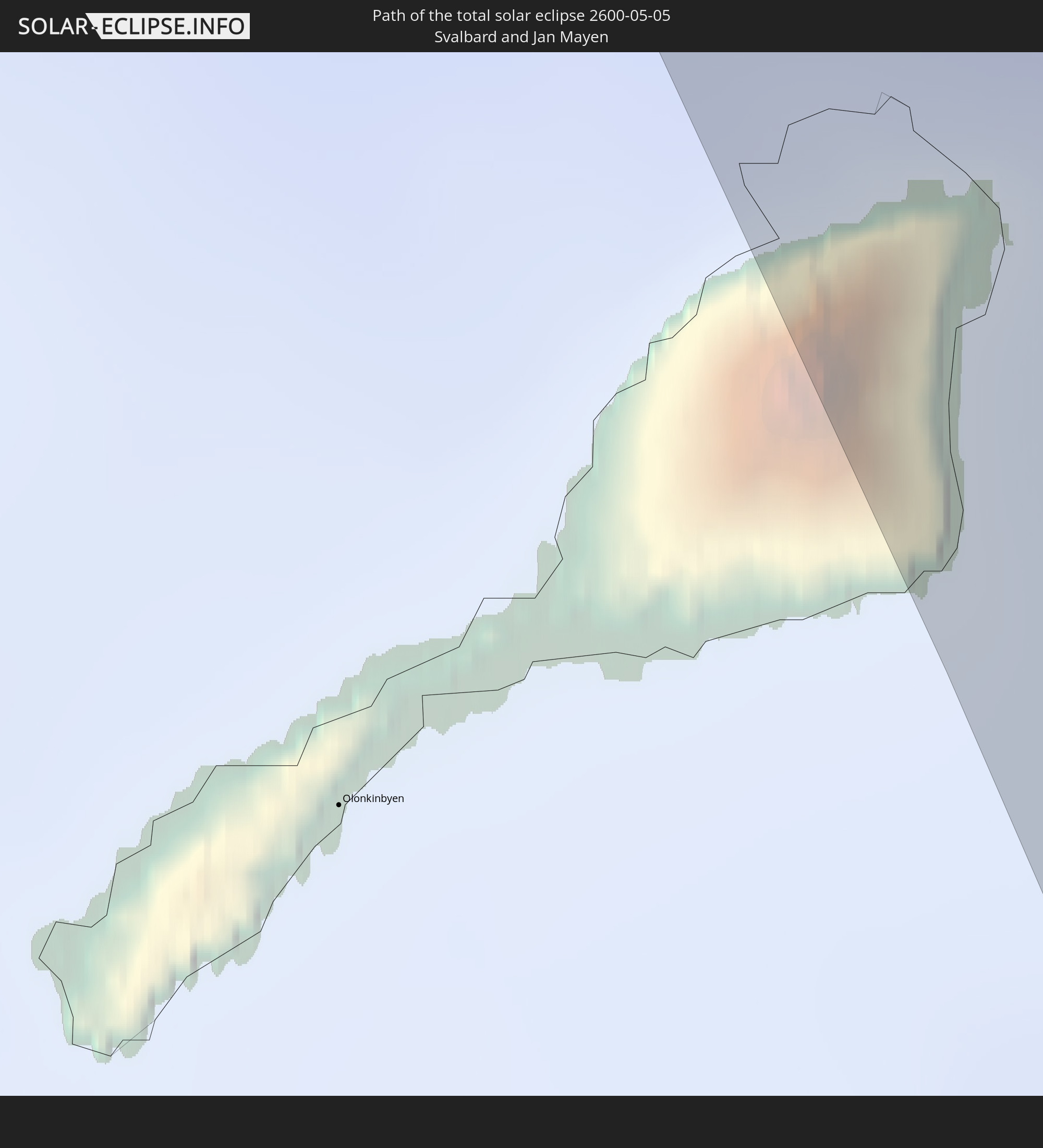 Spitzbergen
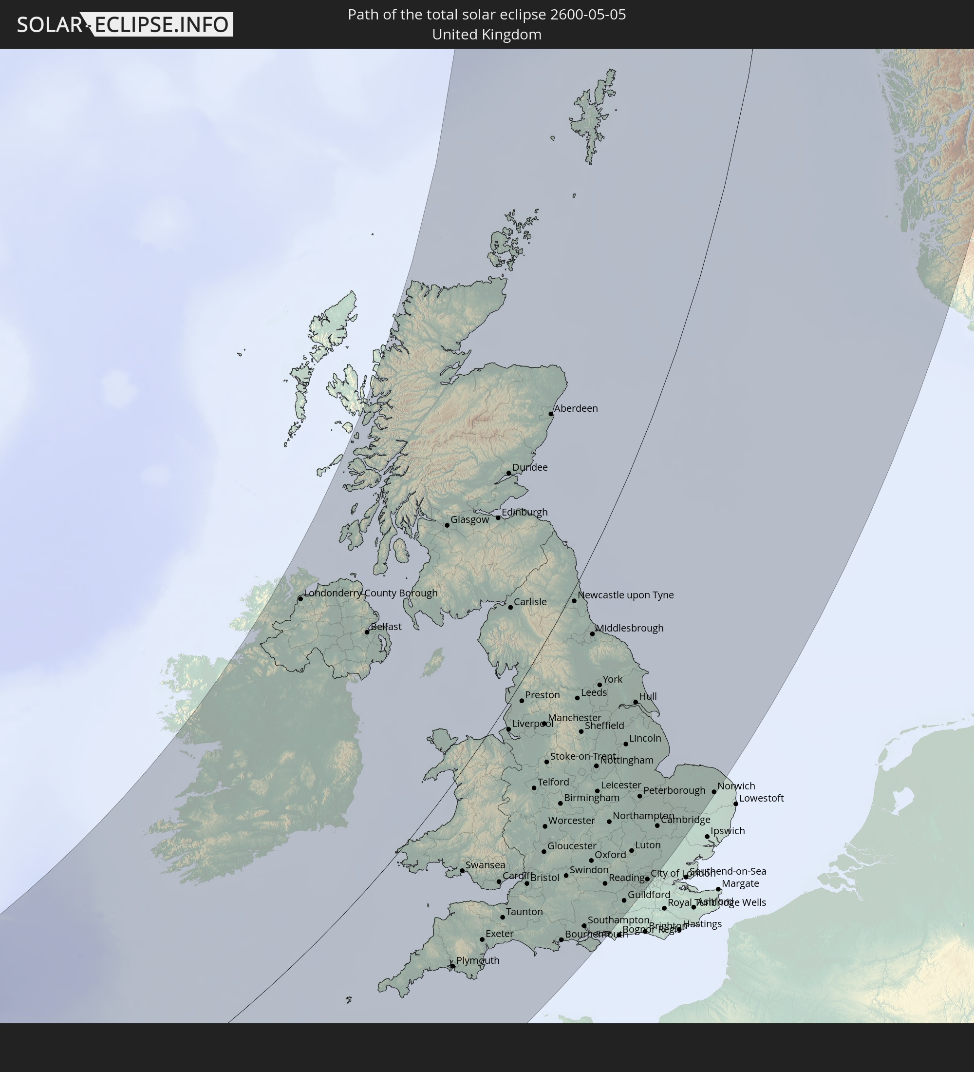 Vereinigtes Königreich
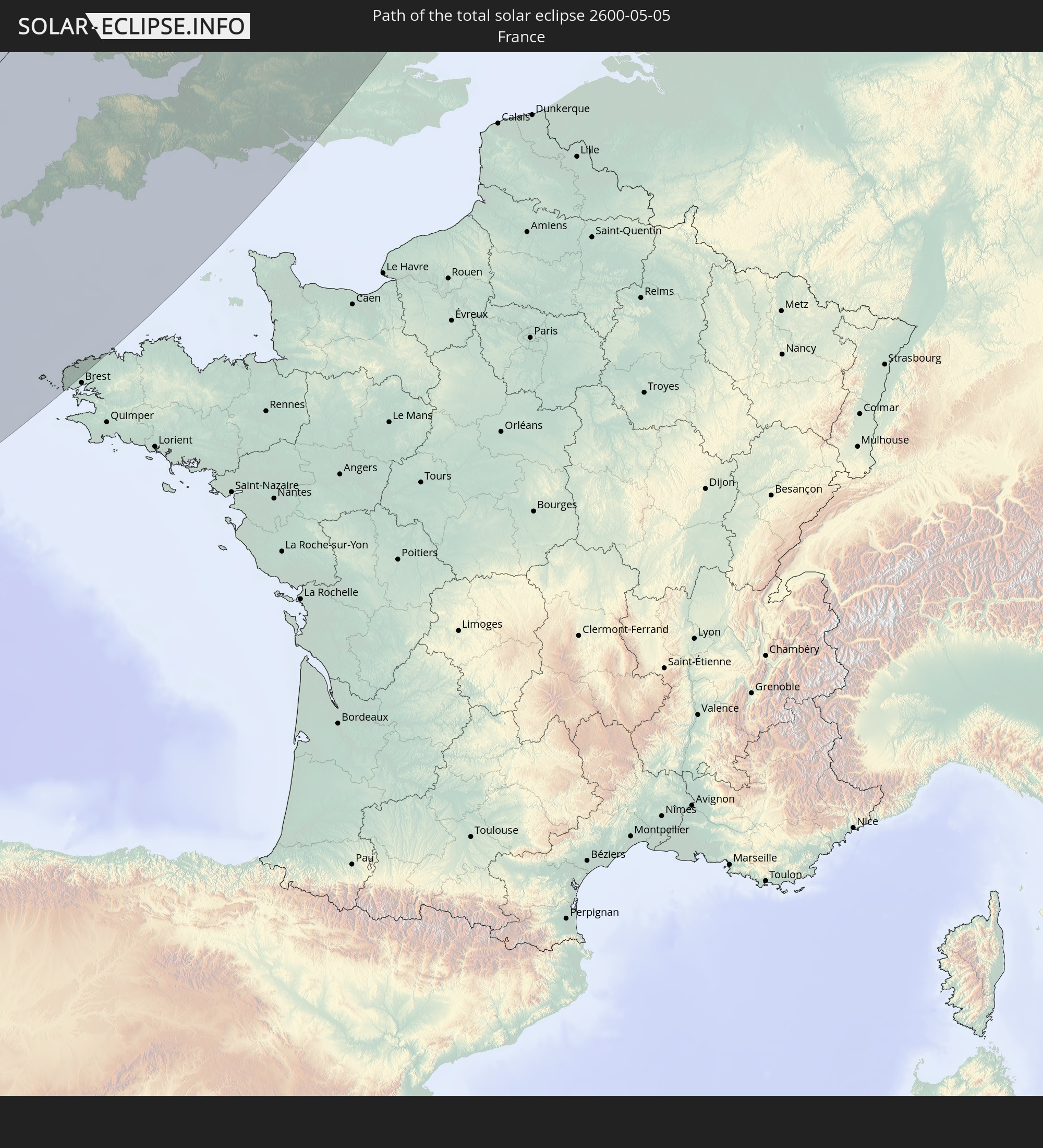 Frankreich
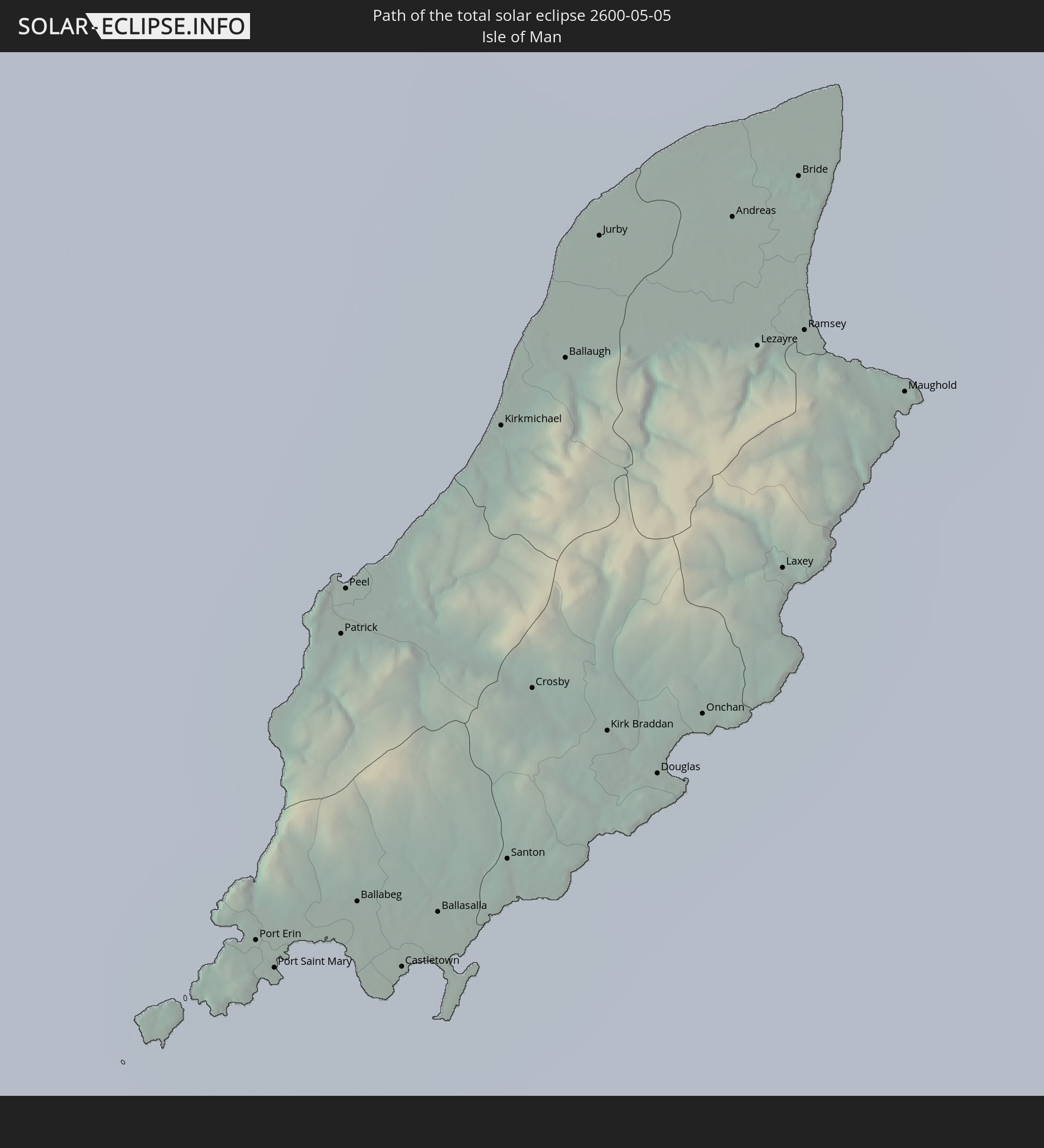 Isle of Man
 Norwegen
In den folgenden Ländern ist die Sonnenfinsternis partiell zu sehen
 Russland
 Vereinigte Staaten
 Kanada
 Grönland
 Portugal
 Island
 Spanien
 Marokko
 Irland
 Spitzbergen
 Algerien
 Vereinigtes Königreich
 Färöer
 Gibraltar
 Frankreich
 Isle of Man
 Guernsey
 Jersey
 Niger
Niger
 Andorra
 Belgien
 Nigeria
 Niederlande
 Norwegen
 Luxemburg
 Deutschland
 Schweiz
 Italien
 Monaco
 Tunesien
 Dänemark
 Kamerun
 Libyen
 Liechtenstein
 Österreich
 Schweden
 Republik Kongo
 Tschechien
 Demokratische Republik Kongo
 San Marino
 Vatikanstadt
 Slowenien
 Tschad
 Kroatien
 Polen
Polen
 Malta
Malta
 Zentralafrikanische Republik
 Bosnien und Herzegowina
 Ungarn
 Slowakei
 Montenegro
 Serbien
 Albanien
 Åland Islands
 Griechenland
 Rumänien
 Mazedonien
 Finnland
 Litauen
 Lettland
 Estland
 Sudan
Sudan
 Ukraine
 Bulgarien
 Weißrussland
 Ägypten
 Türkei
 Moldawien
 Republik Zypern
 Äthiopien
 Staat Palästina
 Israel
 Saudi-Arabien
 Jordanien
 Libanon
 Syrien
 Eritrea
 Irak
Irak
 Georgien
 Jemen
Jemen
 Armenien
 Iran
Iran
 Aserbaidschan
 Kasachstan
 Kuwait
 Bahrain
 Katar
Katar
 Vereinigte Arabische Emirate
 Oman
Oman
 Turkmenistan
 Usbekistan
 Afghanistan
 Pakistan
 Tadschikistan
 Kirgisistan
 Volksrepublik China
 Mongolei
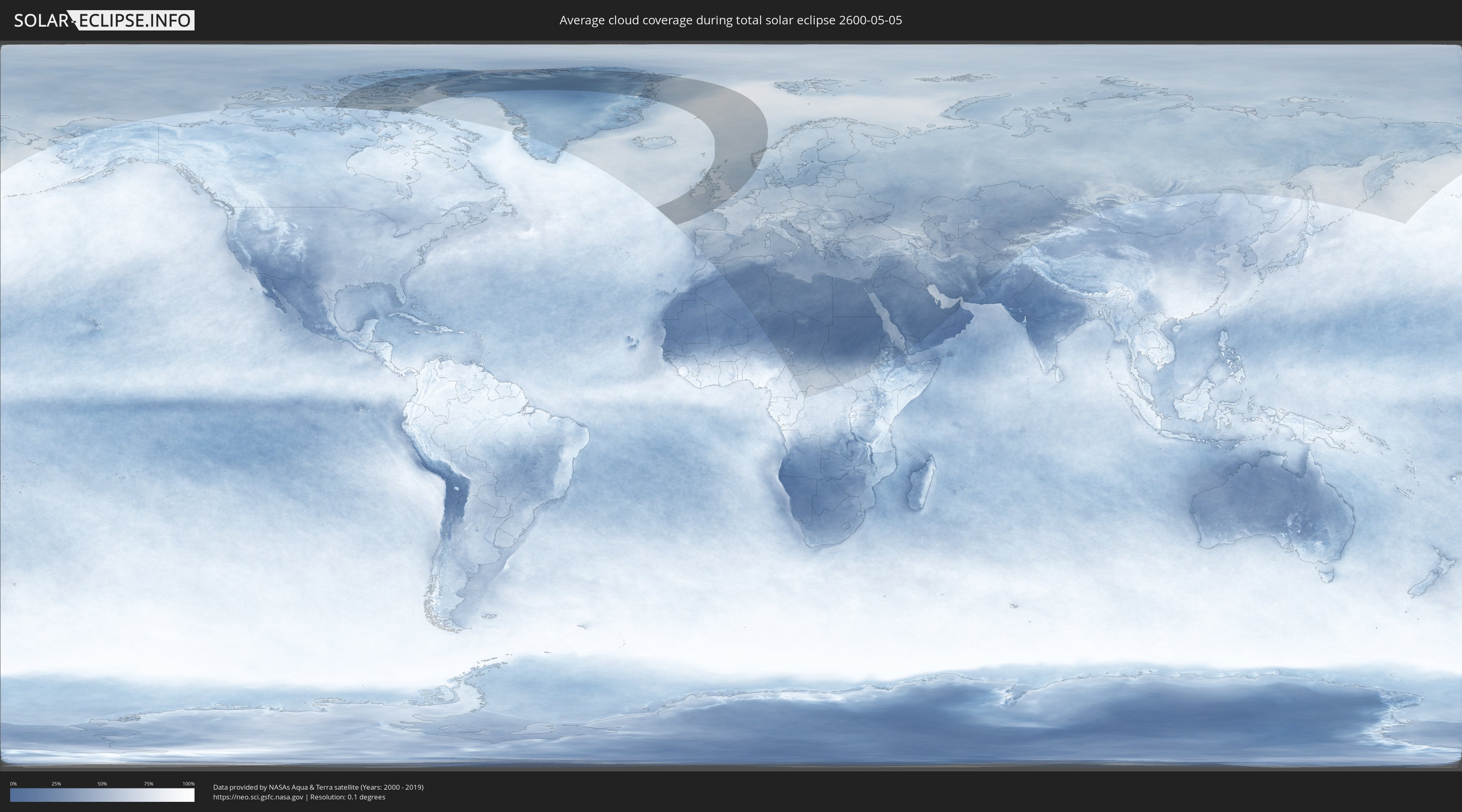
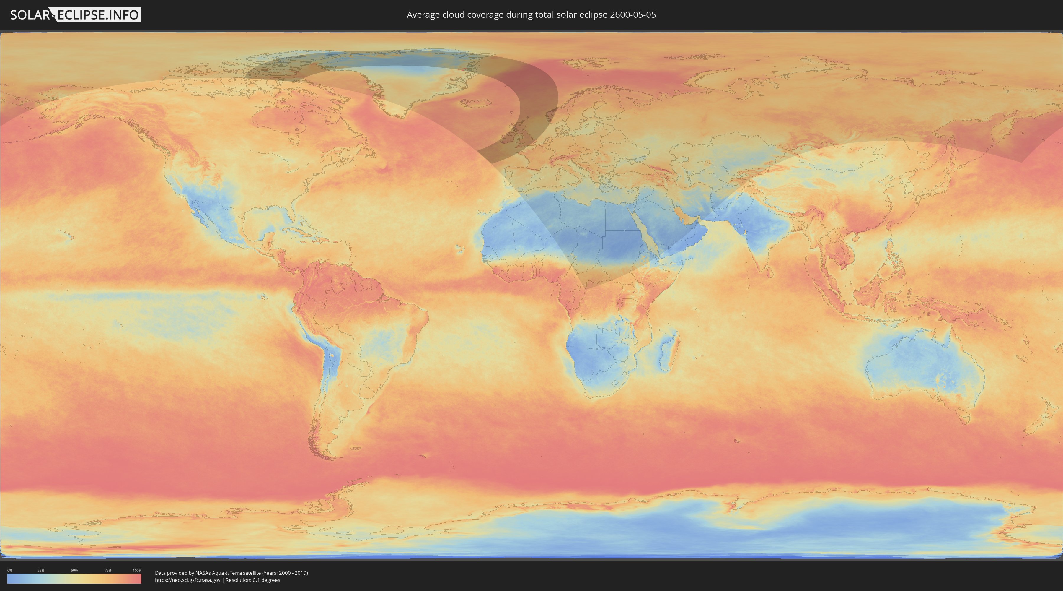
Wie wird das Wetter während der totalen Sonnenfinsternis am 05.05.2600?
Wo ist der beste Ort, um die totale Sonnenfinsternis vom 05.05.2600 zu beobachten?
Die folgenden Karten zeigen die durchschnittliche Bewölkung für den Tag, an dem die totale Sonnenfinsternis
stattfindet. Mit Hilfe der Karten lässt sich der Ort entlang des Finsternispfades eingrenzen,
der die besten Aussichen auf einen klaren wolkenfreien Himmel bietet.
Trotzdem muss man immer lokale Gegenenheiten beachten und sollte sich genau über das Wetter an seinem
gewählten Beobachtungsort informieren.
Die Daten stammen von den beiden NASA-Satelliten
AQUA und TERRA
und wurden über einen Zeitraum von 19 Jahren (2000 - 2019) gemittelt.
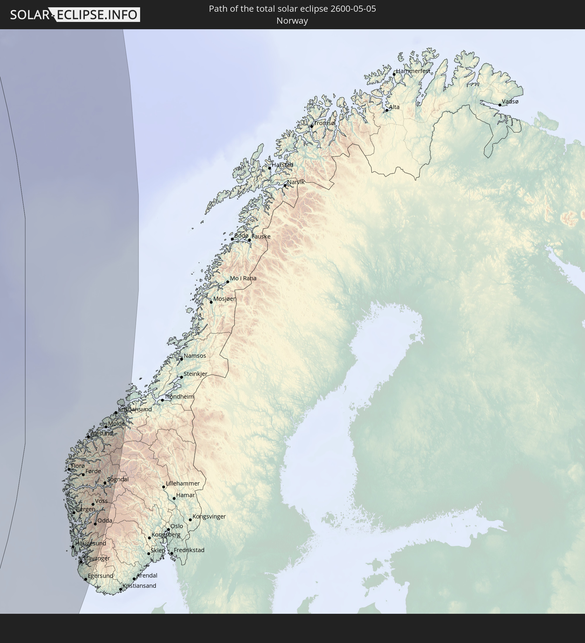
Detaillierte Länderkarten
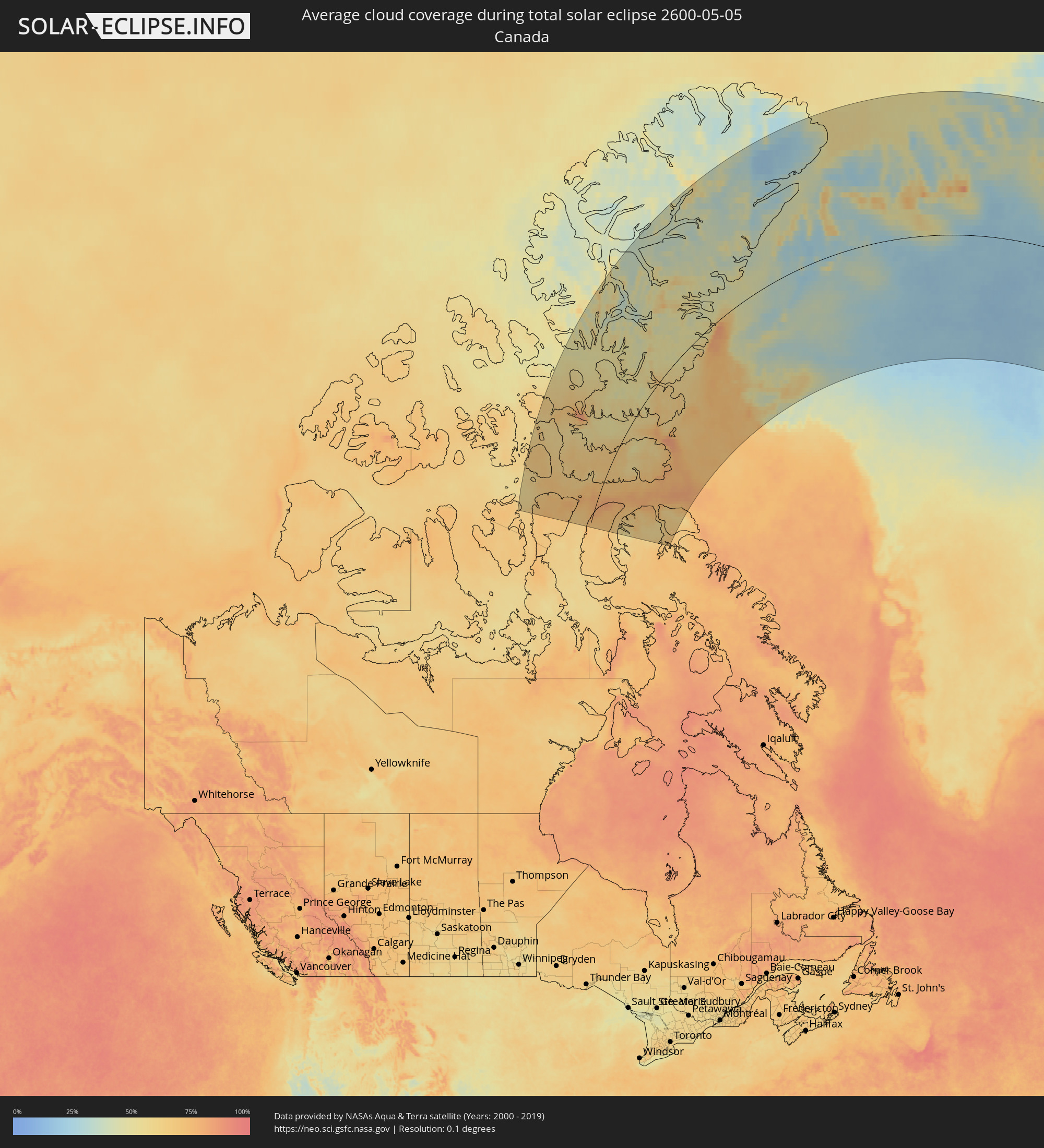 Kanada
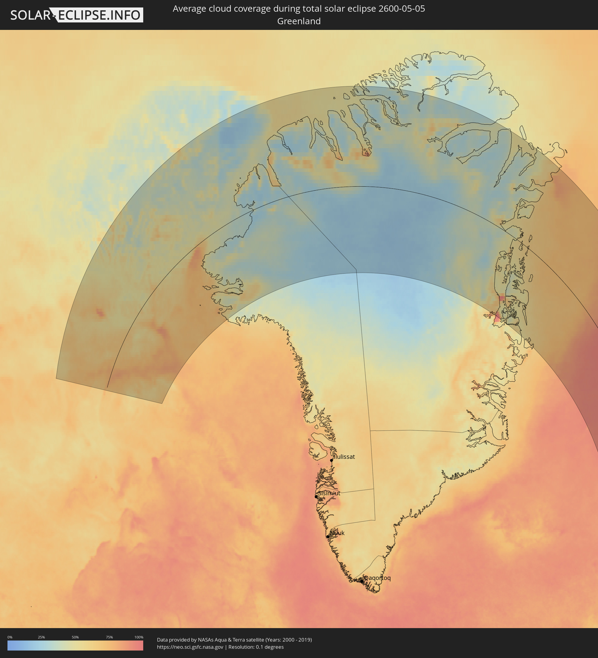 Grönland
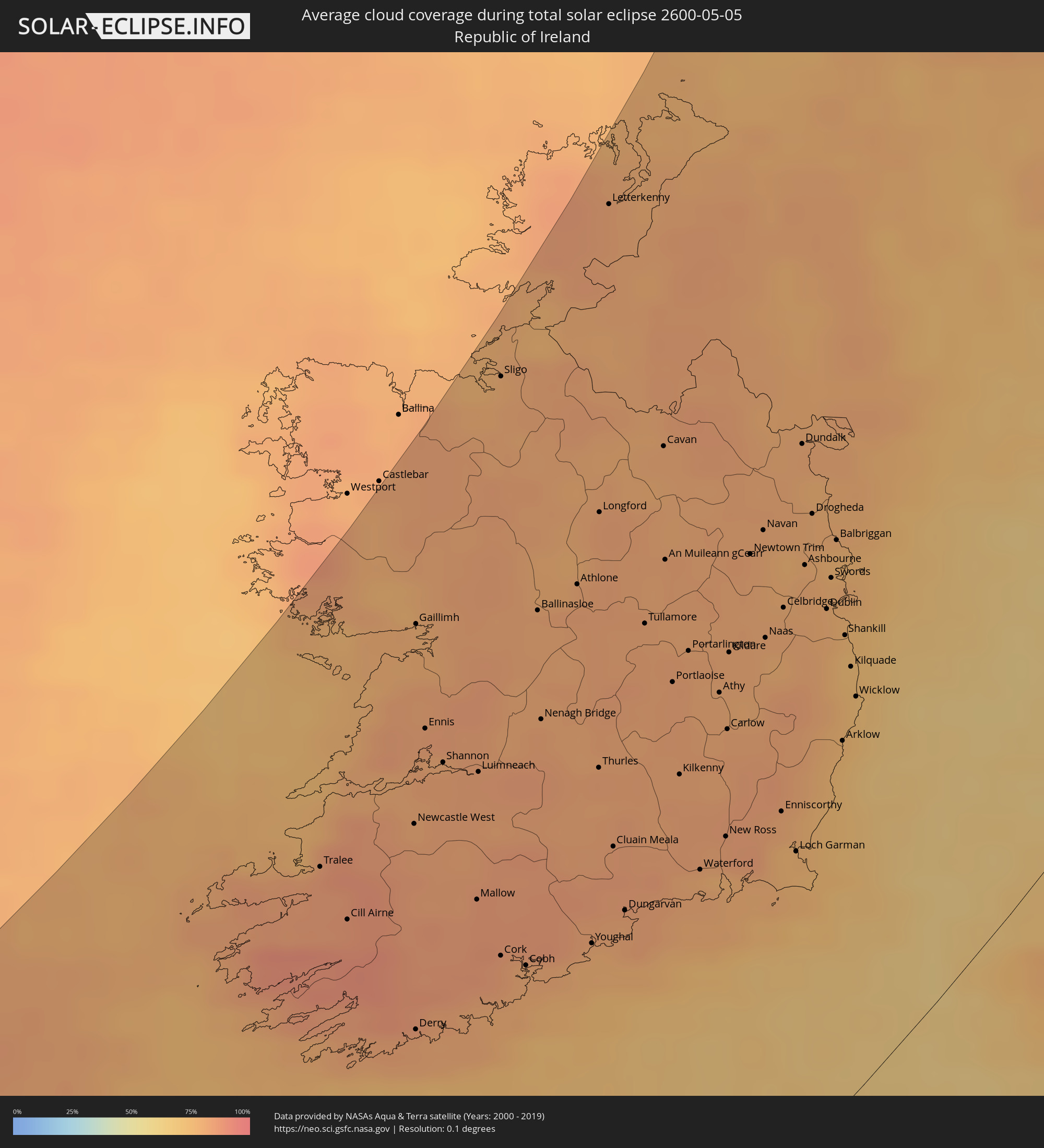 Irland
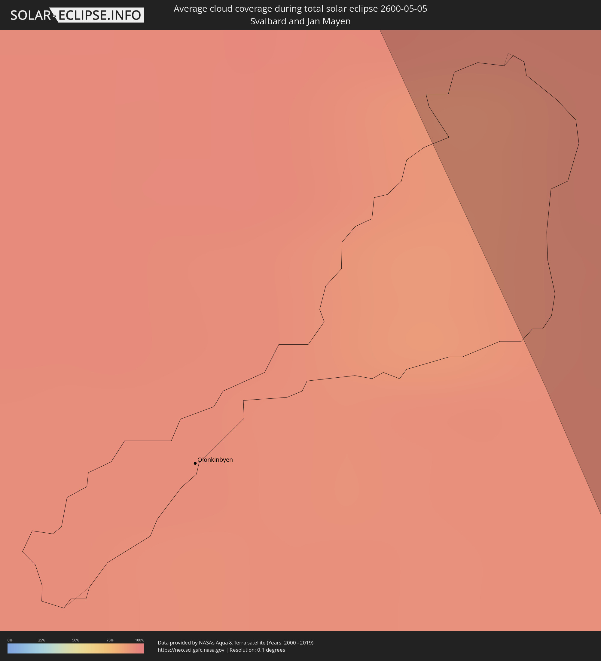 Spitzbergen
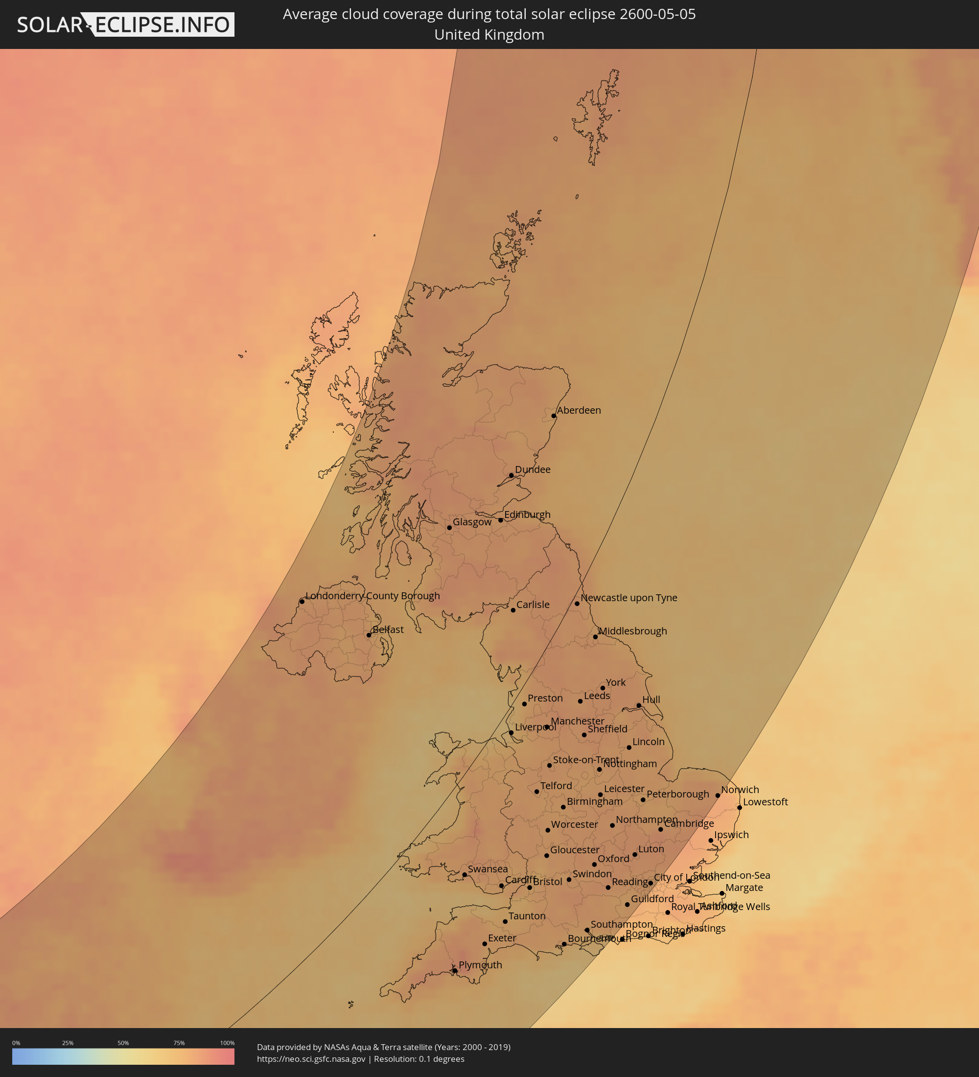 Vereinigtes Königreich
 Frankreich
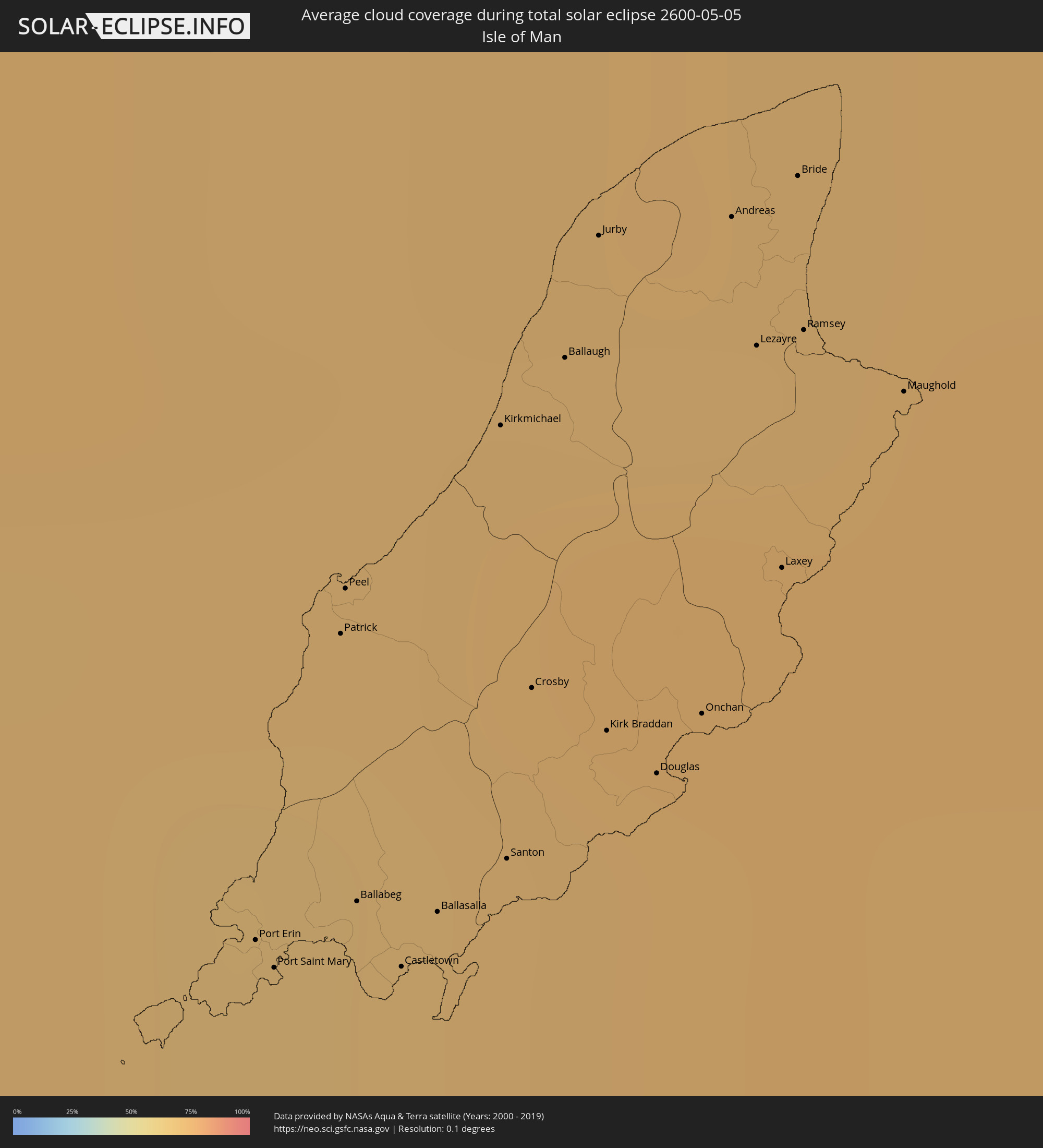 Isle of Man
 Norwegen
Orte im Finsternispfad
Die nachfolgene Tabelle zeigt Städte und Orte mit mehr als 5.000 Einwohnern, die sich im Finsternispfad befinden. Städte mit mehr als 100.000 Einwohnern sind dick gekennzeichnet. Mit einem Klick auf den Ort öffnet sich eine Detailkarte die die Lage des jeweiligen Ortes zusammen mit dem Verlauf der zentralen Finsternis präsentiert.
| Ort | Typ | Dauer der Verfinsterung | Ortszeit bei maximaler Verfinsterung | Entfernung zur Zentrallinie | Ø Bewölkung |
|
Tralee, Munster
|
total | - | 05:55:34 UTC+00:00 | 257 km | 84% |
|
Cill Airne, Munster
|
total | - | 05:55:10 UTC+00:00 | 231 km | 86% |
|
Derry, Munster
|
total | - | 05:54:19 UTC+00:00 | 172 km | 81% |
|
Gaillimh, Connaught
|
total | - | 05:56:58 UTC+00:00 | 296 km | 78% |
|
Ennis, Munster
|
total | - | 05:56:16 UTC+00:00 | 263 km | 81% |
|
Shannon, Munster
|
total | - | 05:56:01 UTC+00:00 | 247 km | 82% |
|
Mallow, Munster
|
total | - | 05:55:03 UTC+00:00 | 193 km | 85% |
|
Luimneach, Munster
|
total | - | 05:55:53 UTC+00:00 | 231 km | 83% |
|
Cork, Munster
|
total | - | 05:54:38 UTC+00:00 | 167 km | 84% |
|
Sligo, Connaught
|
total | - | 05:58:25 UTC+00:00 | 332 km | 77% |
|
Midleton, Munster
|
total | - | 05:54:35 UTC+00:00 | 153 km | 80% |
|
Athlone, Leinster
|
total | - | 05:56:57 UTC+00:00 | 250 km | 82% |
|
Thurles, Munster
|
total | - | 05:55:42 UTC+00:00 | 190 km | 82% |
|
Longford, Leinster
|
total | - | 05:57:23 UTC+00:00 | 261 km | 82% |
|
Letterkenny, Ulster
|
total | - | 05:59:21 UTC+00:00 | 332 km | 81% |
|
Cluain Meala, Munster
|
total | - | 05:55:10 UTC+00:00 | 162 km | 83% |
|
Dungarvan, Munster
|
total | - | 05:54:43 UTC+00:00 | 138 km | 81% |
|
Tullamore, Leinster
|
total | - | 05:56:35 UTC+00:00 | 215 km | 81% |
|
An Muileann gCearr, Leinster
|
total | - | 05:56:58 UTC+00:00 | 224 km | 80% |
|
Portlaoise, Leinster
|
total | - | 05:56:09 UTC+00:00 | 188 km | 82% |
|
Kilkenny, Leinster
|
total | - | 05:55:32 UTC+00:00 | 160 km | 81% |
|
Portarlington, Leinster
|
total | - | 05:56:20 UTC+00:00 | 191 km | 81% |
|
Waterford, Munster
|
total | - | 05:54:51 UTC+00:00 | 124 km | 79% |
|
Athy, Leinster
|
total | - | 05:56:00 UTC+00:00 | 169 km | 80% |
|
Carlow, Leinster
|
total | - | 05:55:45 UTC+00:00 | 155 km | 82% |
|
Kildare, Leinster
|
total | - | 05:56:15 UTC+00:00 | 176 km | 80% |
|
Navan, Leinster
|
total | - | 05:57:00 UTC+00:00 | 196 km | 81% |
|
Naas, Leinster
|
total | - | 05:56:17 UTC+00:00 | 167 km | 80% |
|
Enniscorthy, Leinster
|
total | - | 05:55:07 UTC+00:00 | 112 km | 81% |
|
Celbridge, Leinster
|
total | - | 05:56:28 UTC+00:00 | 168 km | 80% |
|
Loch Garman, Leinster
|
total | - | 05:54:49 UTC+00:00 | 95 km | 76% |
|
Dundalk, Leinster
|
total | - | 05:57:30 UTC+00:00 | 204 km | 80% |
|
Ashbourne, Leinster
|
total | - | 05:56:42 UTC+00:00 | 172 km | 80% |
|
Drogheda, Leinster
|
total | - | 05:57:02 UTC+00:00 | 182 km | 78% |
|
Greenhills, Leinster
|
total | - | 05:56:24 UTC+00:00 | 155 km | 79% |
|
Dublin, Leinster
|
total | - | 05:56:23 UTC+00:00 | 152 km | 78% |
|
Balbriggan, Leinster
|
total | - | 05:56:49 UTC+00:00 | 167 km | 76% |
|
Arklow, Leinster
|
total | - | 05:55:29 UTC+00:00 | 110 km | 73% |
|
Sallynoggin, Leinster
|
total | - | 05:56:16 UTC+00:00 | 143 km | 75% |
|
Kilquade
|
total | - | 05:55:58 UTC+00:00 | 128 km | 74% |
|
Belfast, Northern Ireland
|
total | - | 05:58:23 UTC+00:00 | 212 km | 79% |
|
Port Erin, Port Erin
|
total | - | 05:57:18 UTC+00:00 | 117 km | 71% |
|
Port Saint Mary, Port St Mary
|
total | - | 05:57:17 UTC+00:00 | 116 km | 70% |
|
Patrick, Patrick
|
total | - | 05:57:29 UTC+00:00 | 121 km | 69% |
|
Peel, Peel
|
total | - | 05:57:31 UTC+00:00 | 122 km | 69% |
|
Ballabeg, Arbory
|
total | - | 05:57:19 UTC+00:00 | 114 km | 70% |
|
Castletown, Castletown
|
total | - | 05:57:16 UTC+00:00 | 111 km | 70% |
|
Ploudalmézeau, Brittany
|
total | - | 06:48:19 UTC+01:00 | 291 km | 73% |
|
Ballasalla, Malew
|
total | - | 05:57:17 UTC+00:00 | 111 km | 69% |
|
Saint-Renan, Brittany
|
total | - | 06:48:09 UTC+01:00 | 301 km | 74% |
|
Kirkmichael, Michael
|
total | - | 05:57:36 UTC+00:00 | 120 km | 72% |
|
Santon, Santon
|
total | - | 05:57:19 UTC+00:00 | 110 km | 69% |
|
Rd pt des Chataigniers, Rte de Milizac, Guilers, Finistère, France, Brittany
|
total | - | 06:48:09 UTC+01:00 | 304 km | 74% |
|
Crosby, Marown
|
total | - | 05:57:25 UTC+00:00 | 113 km | 70% |
|
Ballaugh, Ballaugh
|
total | - | 05:57:38 UTC+00:00 | 119 km | 73% |
|
Jurby, Jurby
|
total | - | 05:57:42 UTC+00:00 | 121 km | 70% |
|
Kirk Braddan, Braddan
|
total | - | 05:57:23 UTC+00:00 | 109 km | 72% |
|
Plouguerneau, Brittany
|
total | - | 06:48:23 UTC+01:00 | 293 km | 75% |
|
Douglas, Douglas
|
total | - | 05:57:21 UTC+00:00 | 106 km | 72% |
|
Onchan, Onchan
|
total | - | 05:57:23 UTC+00:00 | 106 km | 72% |
|
Andreas, Andreas
|
total | - | 05:57:42 UTC+00:00 | 116 km | 71% |
|
Lezayre, Lezayre
|
total | - | 05:57:37 UTC+00:00 | 112 km | 73% |
|
Laxey, Laxey
|
total | - | 05:57:28 UTC+00:00 | 107 km | 73% |
|
Bride, Bride
|
total | - | 05:57:43 UTC+00:00 | 115 km | 71% |
|
Ramsey, Ramsey
|
total | - | 05:57:37 UTC+00:00 | 111 km | 73% |
|
Lesneven, Brittany
|
total | - | 06:48:18 UTC+01:00 | 304 km | 79% |
|
Maughold, Maughold
|
total | - | 05:57:34 UTC+00:00 | 106 km | 73% |
|
Glasgow, Scotland
|
total | - | 06:00:10 UTC+00:00 | 185 km | 80% |
|
Plymouth, England
|
total | - | 05:51:07 UTC+00:00 | 170 km | 76% |
|
Swansea, Wales
|
total | - | 05:53:06 UTC+00:00 | 88 km | 74% |
|
Edinburgh, Scotland
|
total | - | 06:00:08 UTC+00:00 | 130 km | 79% |
|
Cardiff, Wales
|
total | - | 05:52:43 UTC+00:00 | 139 km | 75% |
|
Blackpool, England
|
total | - | 05:56:32 UTC+00:00 | 7 km | 67% |
|
Liverpool, England
|
total | - | 05:55:51 UTC+00:00 | 21 km | 70% |
|
Dundee, Scotland
|
total | - | 06:00:59 UTC+00:00 | 141 km | 78% |
|
Preston, England
|
total | - | 05:56:23 UTC+00:00 | 15 km | 76% |
|
Bristol, England
|
total | - | 05:52:33 UTC+00:00 | 172 km | 77% |
|
Bolton, England
|
total | - | 05:56:02 UTC+00:00 | 41 km | 79% |
|
Manchester, England
|
total | - | 05:55:50 UTC+00:00 | 58 km | 80% |
|
Stoke-on-Trent, England
|
total | - | 05:55:02 UTC+00:00 | 91 km | 80% |
|
Wolverhampton, England
|
total | - | 05:54:20 UTC+00:00 | 121 km | 77% |
|
Aberdeen, Scotland
|
total | - | 06:02:00 UTC+00:00 | 119 km | 77% |
|
Birmingham, England
|
total | - | 05:54:07 UTC+00:00 | 140 km | 78% |
|
Bournemouth, England
|
total | - | 05:51:12 UTC+00:00 | 263 km | 70% |
|
Huddersfield, England
|
total | - | 05:56:03 UTC+00:00 | 73 km | 81% |
|
Swindon, England
|
total | - | 05:52:34 UTC+00:00 | 209 km | 79% |
|
Newcastle upon Tyne, England
|
total | - | 05:58:15 UTC+00:00 | 8 km | 80% |
|
Leeds, England
|
total | - | 05:56:15 UTC+00:00 | 78 km | 80% |
|
Coventry, England
|
total | - | 05:53:55 UTC+00:00 | 166 km | 79% |
|
Derby, England
|
total | - | 05:54:47 UTC+00:00 | 135 km | 77% |
|
Sheffield, England
|
total | - | 05:55:33 UTC+00:00 | 107 km | 81% |
|
Southampton, England
|
total | - | 05:51:25 UTC+00:00 | 275 km | 71% |
|
Sunderland, England
|
total | - | 05:58:06 UTC+00:00 | 25 km | 77% |
|
Oxford, England
|
total | - | 05:52:48 UTC+00:00 | 224 km | 79% |
|
Middlesbrough, England
|
total | - | 05:57:31 UTC+00:00 | 51 km | 79% |
|
Nottingham, England
|
total | - | 05:54:47 UTC+00:00 | 151 km | 78% |
|
Leicester, England
|
total | - | 05:54:15 UTC+00:00 | 172 km | 79% |
|
Portsmouth, England
|
total | - | 05:51:11 UTC+00:00 | 299 km | 66% |
|
York, England
|
total | - | 05:56:27 UTC+00:00 | 94 km | 81% |
|
Reading, England
|
total | - | 05:52:15 UTC+00:00 | 260 km | 78% |
|
Northampton, England
|
total | - | 05:53:33 UTC+00:00 | 211 km | 81% |
|
Milton Keynes, England
|
total | - | 05:53:11 UTC+00:00 | 232 km | 82% |
|
Luton, England
|
total | - | 05:52:52 UTC+00:00 | 261 km | 81% |
|
Hull, England
|
total | - | 05:55:59 UTC+00:00 | 149 km | 79% |
|
London, England
|
total | - | 05:52:12 UTC+00:00 | 302 km | 79% |
|
Norwich, England
|
total | - | 05:53:52 UTC+00:00 | 308 km | 82% |
|
Florø, Sogn og Fjordane
|
total | - | 07:09:24 UTC+01:00 | 144 km | 81% |
|
Askøy, Hordaland
|
total | - | 07:07:14 UTC+01:00 | 179 km | 72% |
|
Åkrehamn, Rogaland
|
total | - | 07:05:12 UTC+01:00 | 212 km | 67% |
|
Haugesund, Rogaland
|
total | - | 07:05:28 UTC+01:00 | 212 km | 66% |
|
Ytrebygda, Hordaland
|
total | - | 07:07:04 UTC+01:00 | 187 km | 75% |
|
Kopervik, Rogaland
|
total | - | 07:05:14 UTC+01:00 | 218 km | 67% |
|
Bergen, Hordaland
|
total | - | 07:07:13 UTC+01:00 | 186 km | 72% |
|
Indre Arna, Hordaland
|
total | - | 07:07:16 UTC+01:00 | 194 km | 77% |
|
Leirvik, Hordaland
|
total | - | 07:06:07 UTC+01:00 | 214 km | 75% |
|
Tananger, Rogaland
|
total | - | 07:04:36 UTC+01:00 | 244 km | 65% |
|
Bryne, Rogaland
|
total | - | 07:04:15 UTC+01:00 | 255 km | 67% |
|
Stavanger, Rogaland
|
total | - | 07:04:40 UTC+01:00 | 251 km | 68% |
|
Sandnes, Rogaland
|
total | - | 07:04:27 UTC+01:00 | 256 km | 66% |
|
Ulsteinvik, Møre og Romsdal
|
total | - | 07:10:45 UTC+01:00 | 173 km | 84% |
|
Hommersåk, Rogaland
|
total | - | 07:04:35 UTC+01:00 | 259 km | 71% |
|
Førde, Sogn og Fjordane
|
total | - | 07:09:08 UTC+01:00 | 190 km | 85% |
|
Egersund, Rogaland
|
total | - | 07:03:44 UTC+01:00 | 285 km | 65% |
|
Jørpeland, Rogaland
|
total | - | 07:04:46 UTC+01:00 | 266 km | 73% |
|
Volda, Møre og Romsdal
|
total | - | 07:10:24 UTC+01:00 | 186 km | 85% |
|
Ørsta, Møre og Romsdal
|
total | - | 07:10:29 UTC+01:00 | 188 km | 85% |
|
Ålesund, Møre og Romsdal
|
total | - | 07:10:59 UTC+01:00 | 189 km | 83% |
|
Voss, Hordaland
|
total | - | 07:07:39 UTC+01:00 | 239 km | 81% |
|
Odda, Hordaland
|
total | - | 07:06:39 UTC+01:00 | 261 km | 81% |
|
Hermansverk, Sogn og Fjordane
|
total | - | 07:08:40 UTC+01:00 | 248 km | 82% |
|
Sogndal, Sogn og Fjordane
|
total | - | 07:08:45 UTC+01:00 | 260 km | 80% |
|
Molde, Møre og Romsdal
|
total | - | 07:11:30 UTC+01:00 | 244 km | 81% |
|
Kristiansund, Møre og Romsdal
|
total | - | 07:12:12 UTC+01:00 | 281 km | 78% |