Totale Sonnenfinsternis vom 07.05.2627
| Wochentag: | Montag |
| Maximale Dauer der Verfinsterung: | 05m22s |
| Maximale Breite des Finsternispfades: | 246 km |
| Saroszyklus: | 148 |
| Bedeckungsgrad: | 100% |
| Magnitude: | 1.0688 |
| Gamma: | 0.4129 |
Wo kann man die Sonnenfinsternis vom 07.05.2627 sehen?
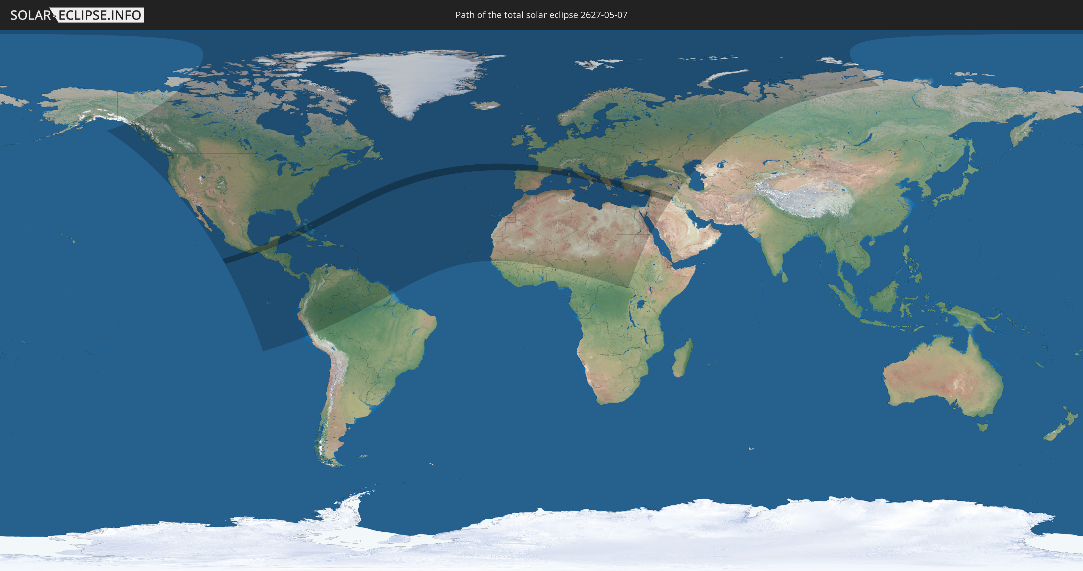
Die Sonnenfinsternis am 07.05.2627 kann man in 131 Ländern als partielle Sonnenfinsternis beobachten.
Der Finsternispfad verläuft durch 17 Länder. Nur in diesen Ländern ist sie als totale Sonnenfinsternis zu sehen.
In den folgenden Ländern ist die Sonnenfinsternis total zu sehen
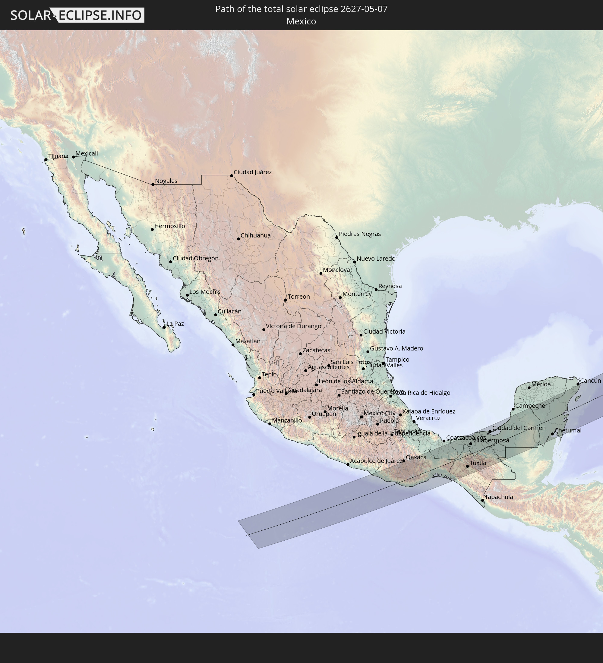 Mexiko
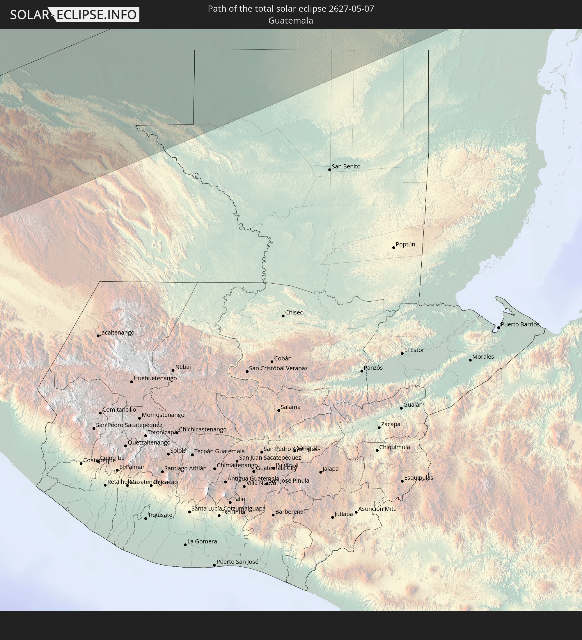 Guatemala
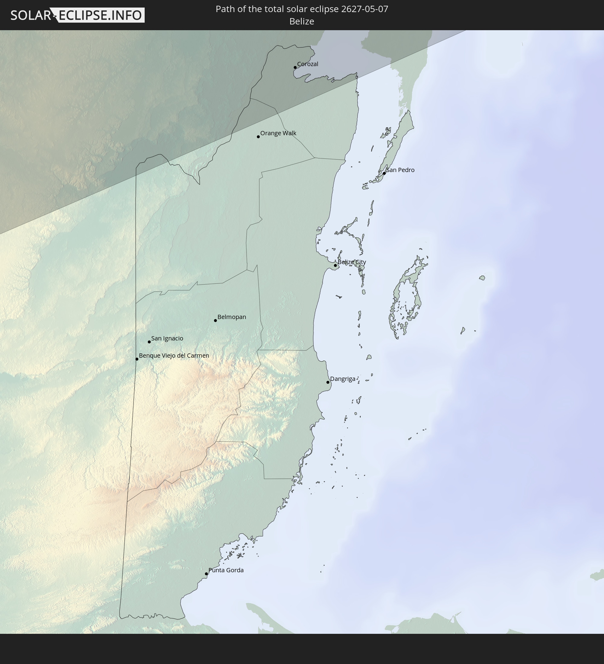 Belize
 Kuba
Kuba
 Bahamas
 Spanien
 Frankreich
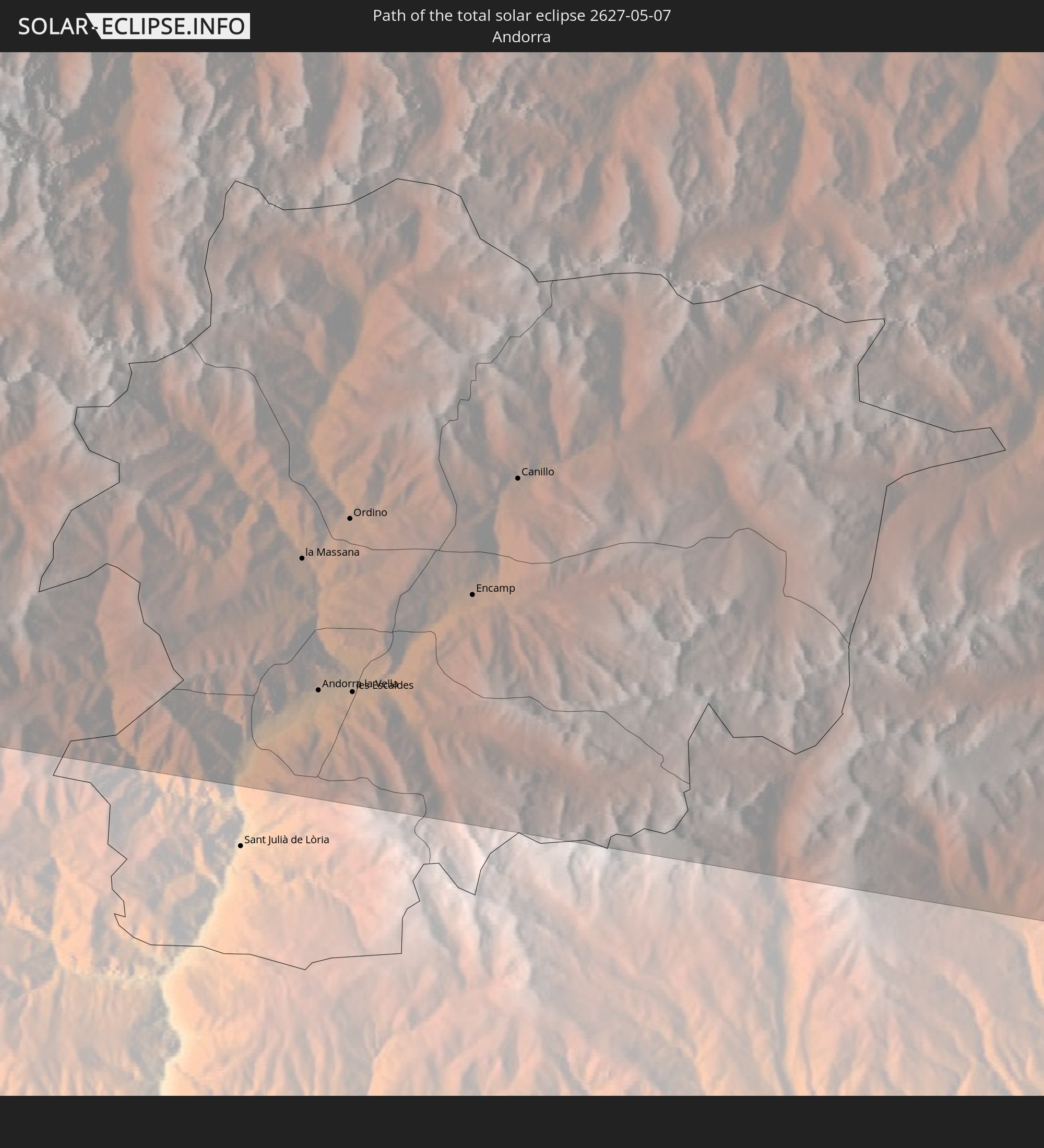 Andorra
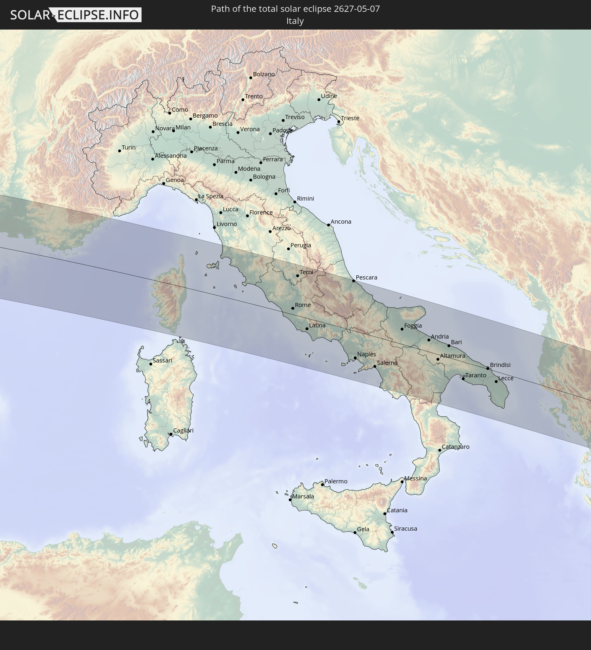 Italien
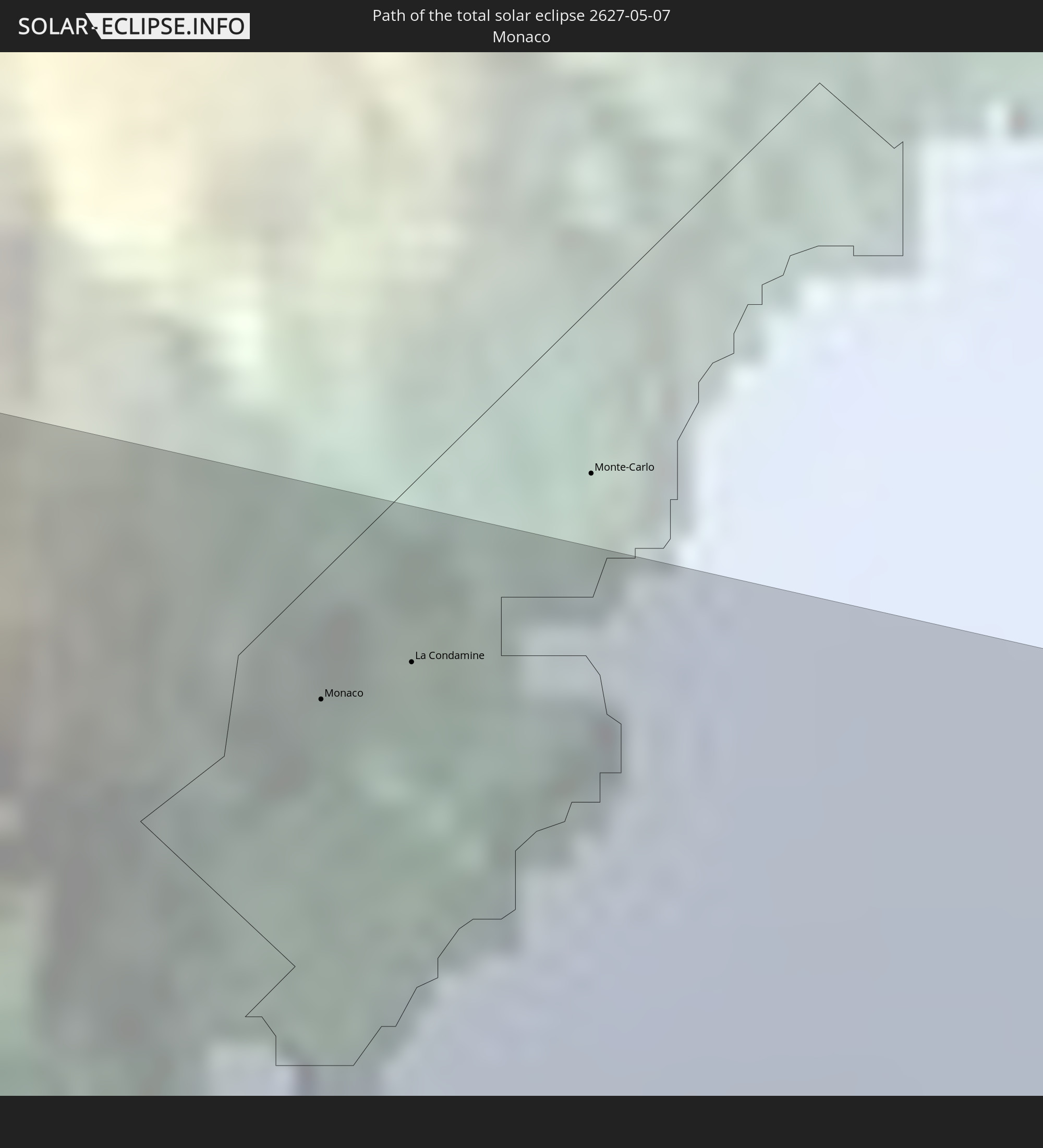 Monaco
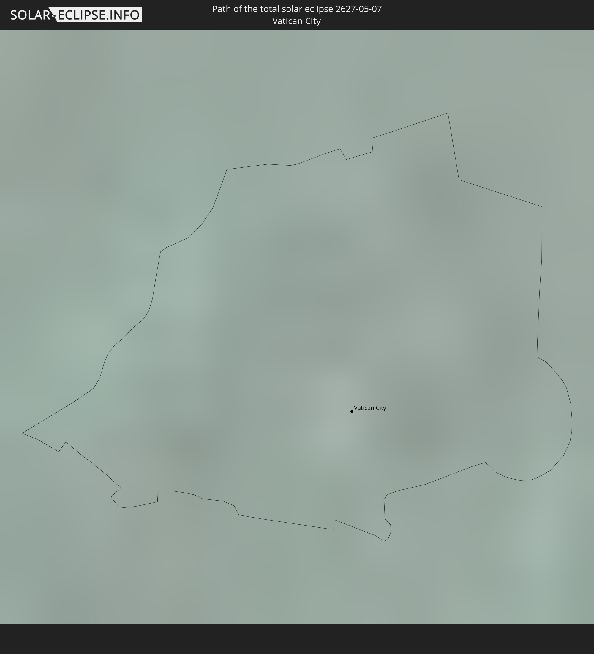 Vatikanstadt
 Albanien
 Griechenland
 Mazedonien
 Türkei
 Syrien
 Irak
Irak
In den folgenden Ländern ist die Sonnenfinsternis partiell zu sehen
 Russland
 Vereinigte Staaten
 United States Minor Outlying Islands
 Kanada
 Mexiko
 Grönland
 Guatemala
 Ecuador
 El Salvador
 Honduras
 Belize
 Nicaragua
 Costa Rica
 Kuba
Kuba
 Panama
 Kolumbien
 Kaimaninseln
 Peru
Peru
 Bahamas
 Jamaika
 Haiti
Haiti
 Brasilien
 Venezuela
 Turks- und Caicosinseln
 Dominikanische Republik
 Aruba
Aruba
 Puerto Rico
 Amerikanische Jungferninseln
 Bermuda
 Britische Jungferninseln
 Anguilla
 Saint-Martin
 Saint-Barthélemy
 St. Kitts und Nevis
 Antigua und Barbuda
 Montserrat
 Trinidad und Tobago
 Guadeloupe
 Grenada
 Dominica
 St. Vincent und die Grenadinen
 Guyana
 Martinique
 St. Lucia
 Barbados
 Suriname
 Saint-Pierre und Miquelon
 Französisch-Guayana
 Portugal
 Kap Verde
 Island
 Spanien
 Senegal
 Mauretanien
 Gambia
 Marokko
 Mali
Mali
 Irland
 Spitzbergen
 Algerien
 Vereinigtes Königreich
 Färöer
 Burkina Faso
 Gibraltar
 Frankreich
 Isle of Man
 Guernsey
 Jersey
 Niger
Niger
 Benin
Benin
 Andorra
 Belgien
 Nigeria
 Niederlande
 Norwegen
 Luxemburg
 Deutschland
 Schweiz
 Italien
 Monaco
 Tunesien
 Dänemark
 Kamerun
 Libyen
 Liechtenstein
 Österreich
 Schweden
 Tschechien
 Demokratische Republik Kongo
 San Marino
 Vatikanstadt
 Slowenien
 Tschad
 Kroatien
 Polen
Polen
 Malta
Malta
 Zentralafrikanische Republik
 Bosnien und Herzegowina
 Ungarn
 Slowakei
 Montenegro
 Serbien
 Albanien
 Åland Islands
 Griechenland
 Rumänien
 Mazedonien
 Finnland
 Litauen
 Lettland
 Estland
 Sudan
Sudan
 Ukraine
 Bulgarien
 Weißrussland
 Ägypten
 Türkei
 Moldawien
 Republik Zypern
 Staat Palästina
 Israel
 Saudi-Arabien
 Jordanien
 Libanon
 Syrien
 Irak
Irak
 Georgien
 Armenien
 Iran
Iran
 Aserbaidschan
 Kasachstan
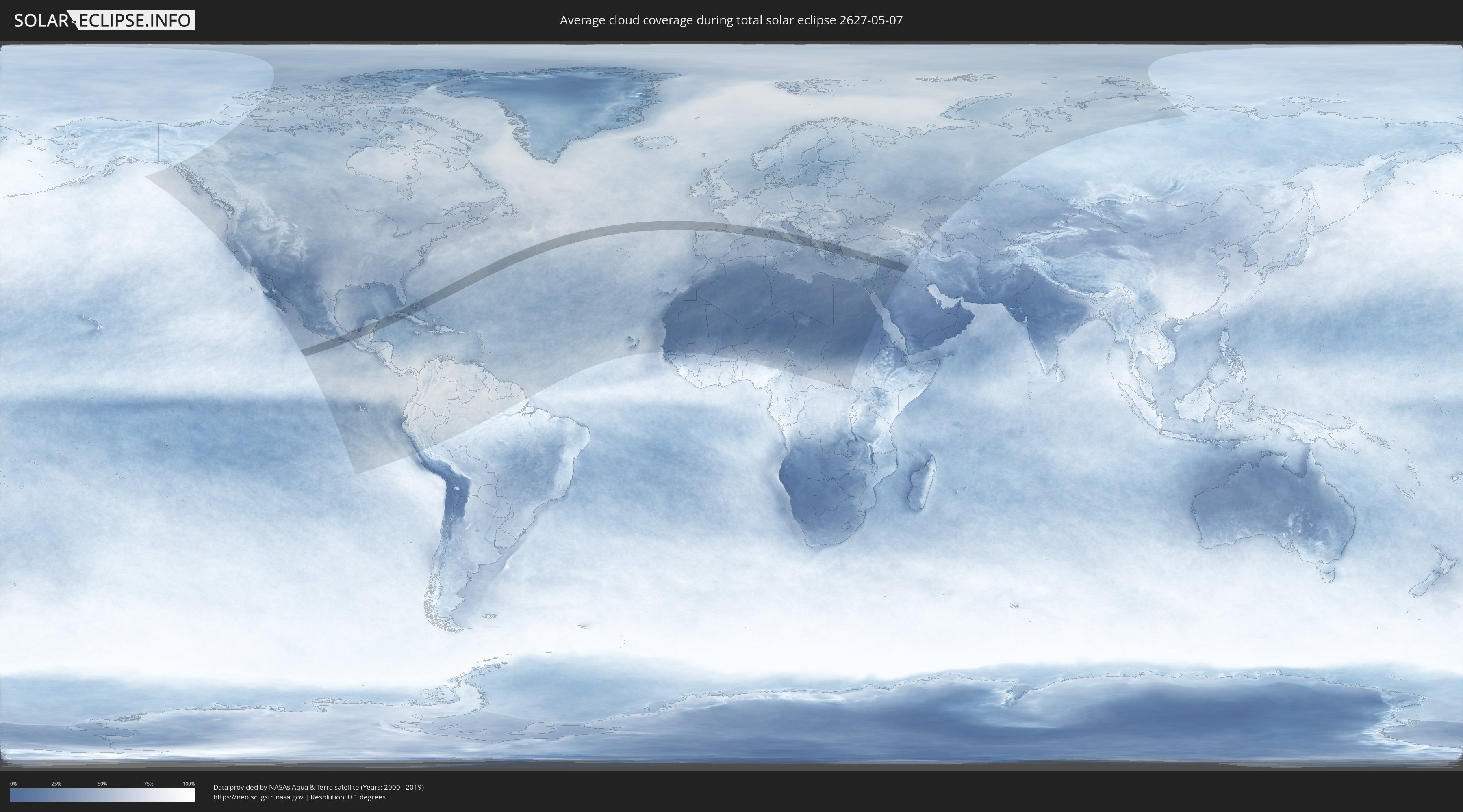
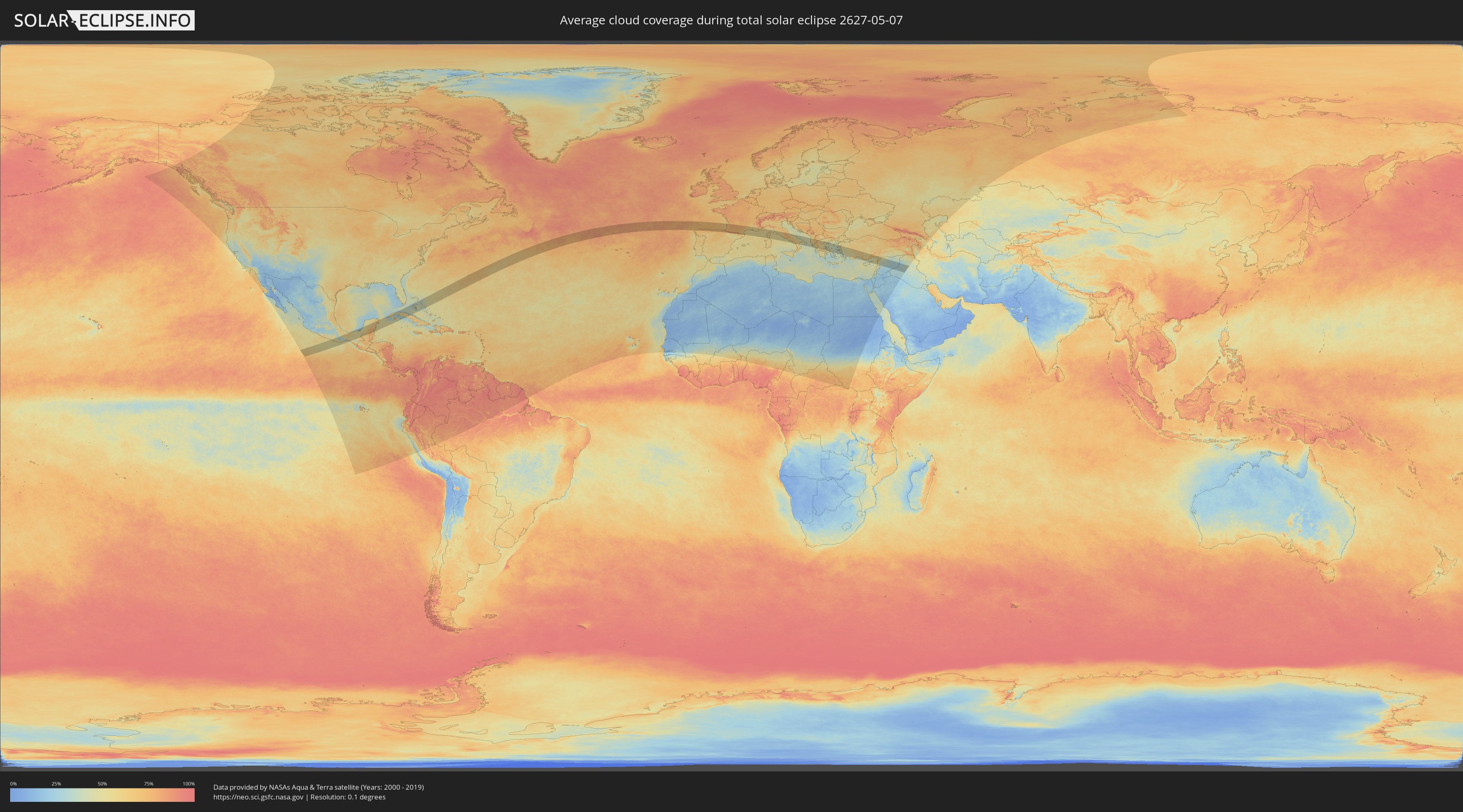
Wie wird das Wetter während der totalen Sonnenfinsternis am 07.05.2627?
Wo ist der beste Ort, um die totale Sonnenfinsternis vom 07.05.2627 zu beobachten?
Die folgenden Karten zeigen die durchschnittliche Bewölkung für den Tag, an dem die totale Sonnenfinsternis
stattfindet. Mit Hilfe der Karten lässt sich der Ort entlang des Finsternispfades eingrenzen,
der die besten Aussichen auf einen klaren wolkenfreien Himmel bietet.
Trotzdem muss man immer lokale Gegenenheiten beachten und sollte sich genau über das Wetter an seinem
gewählten Beobachtungsort informieren.
Die Daten stammen von den beiden NASA-Satelliten
AQUA und TERRA
und wurden über einen Zeitraum von 19 Jahren (2000 - 2019) gemittelt.
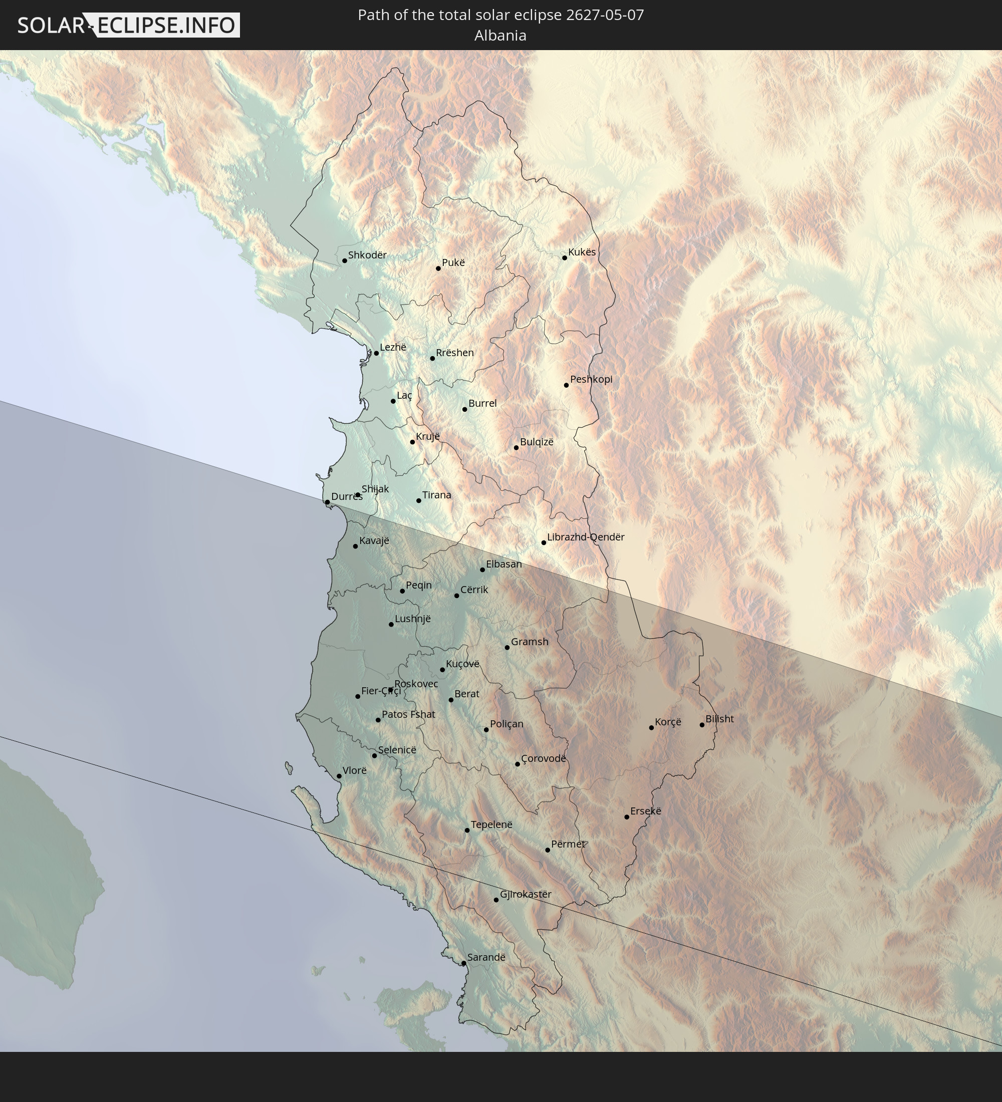
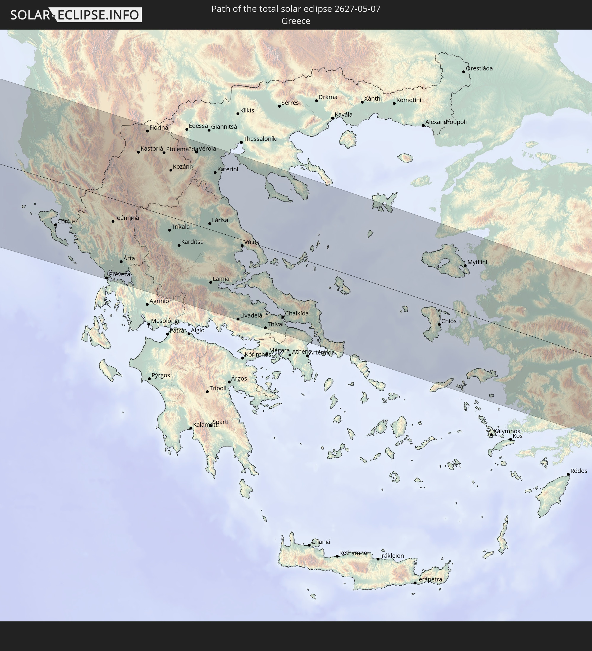
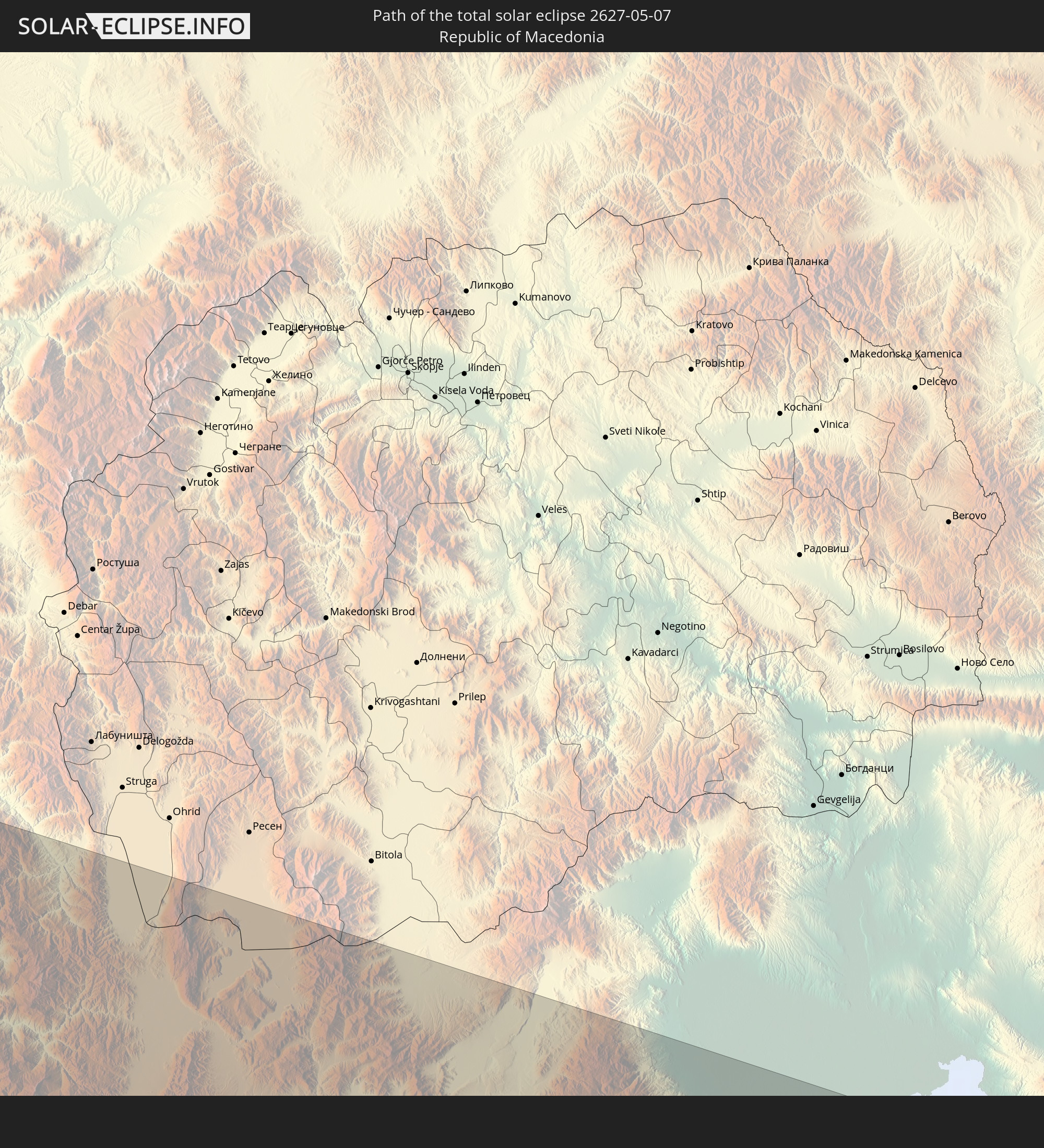
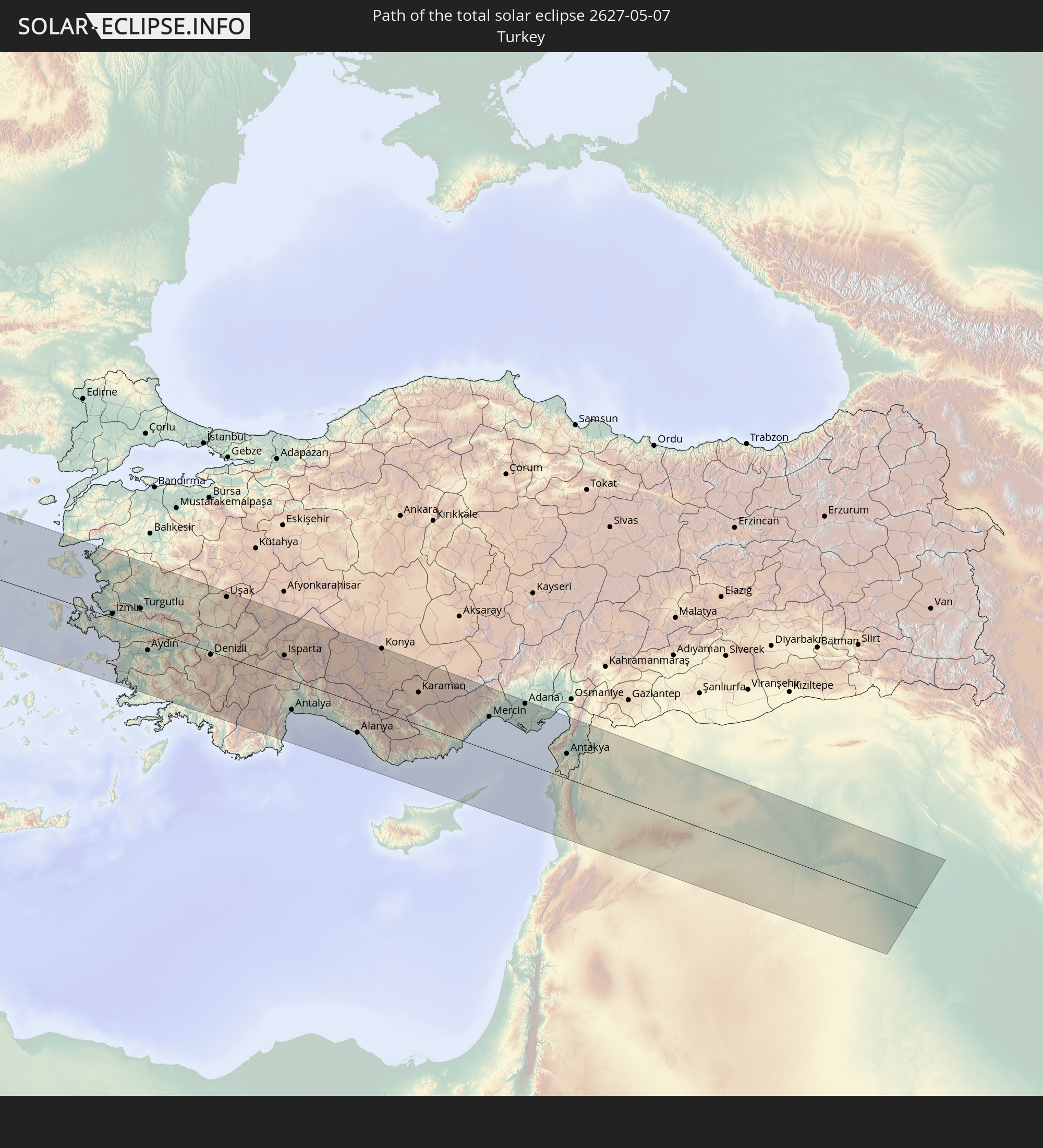
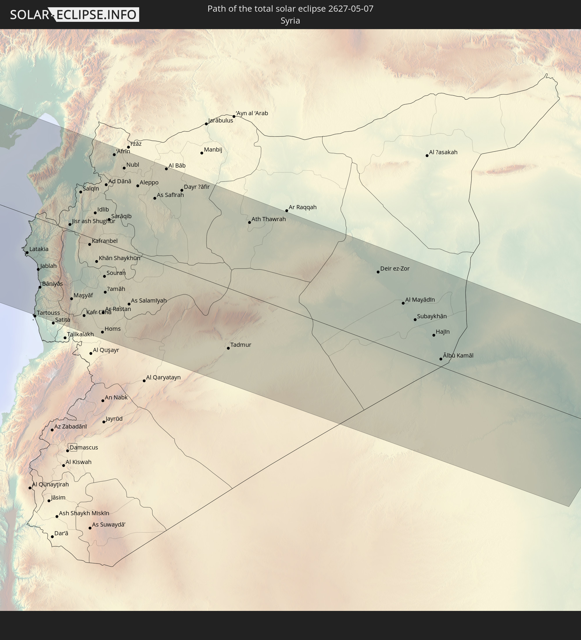
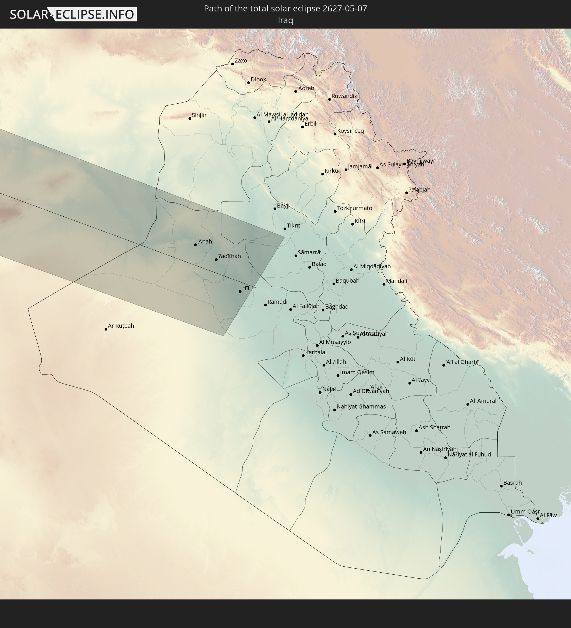
Detaillierte Länderkarten
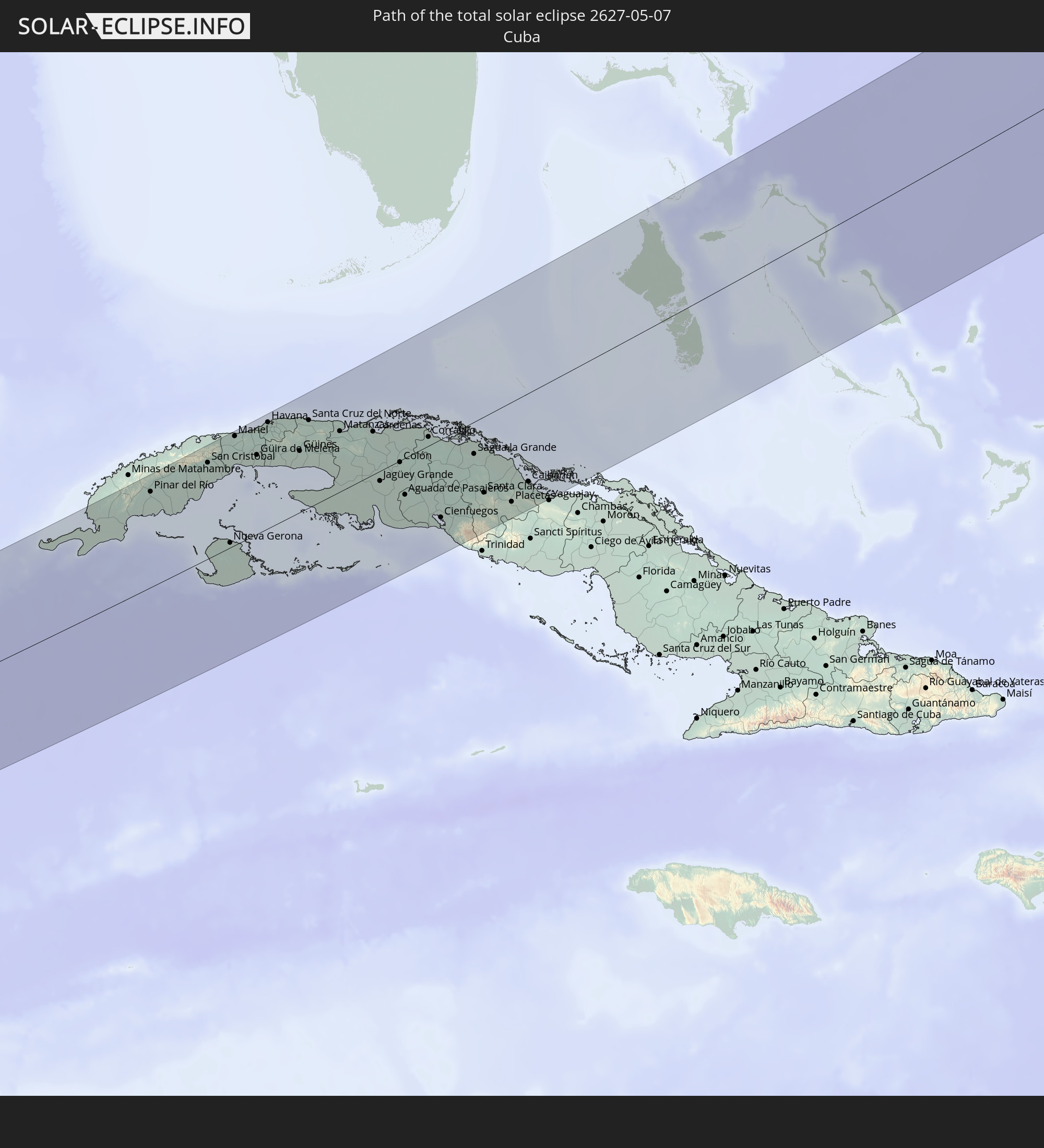
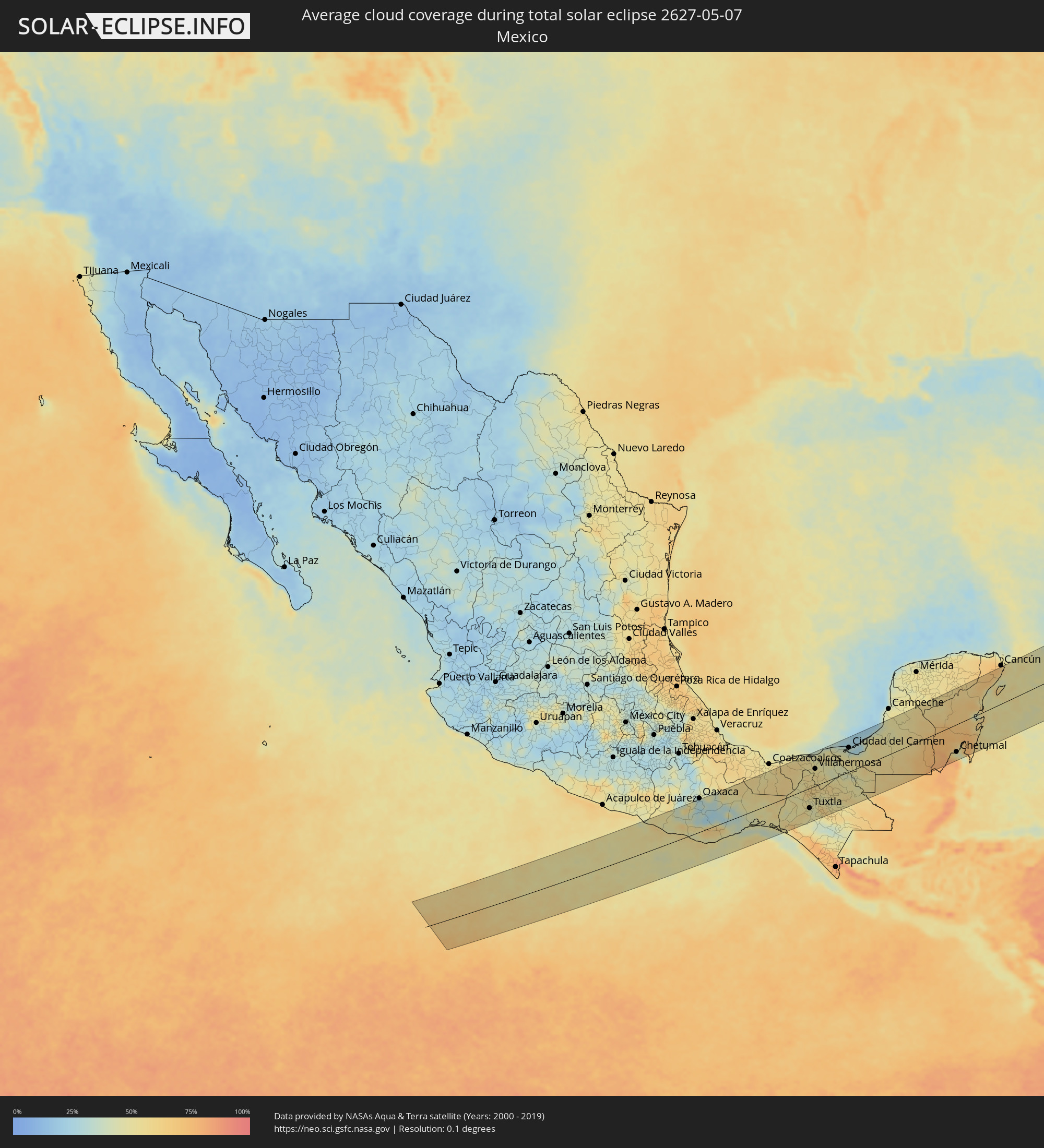 Mexiko
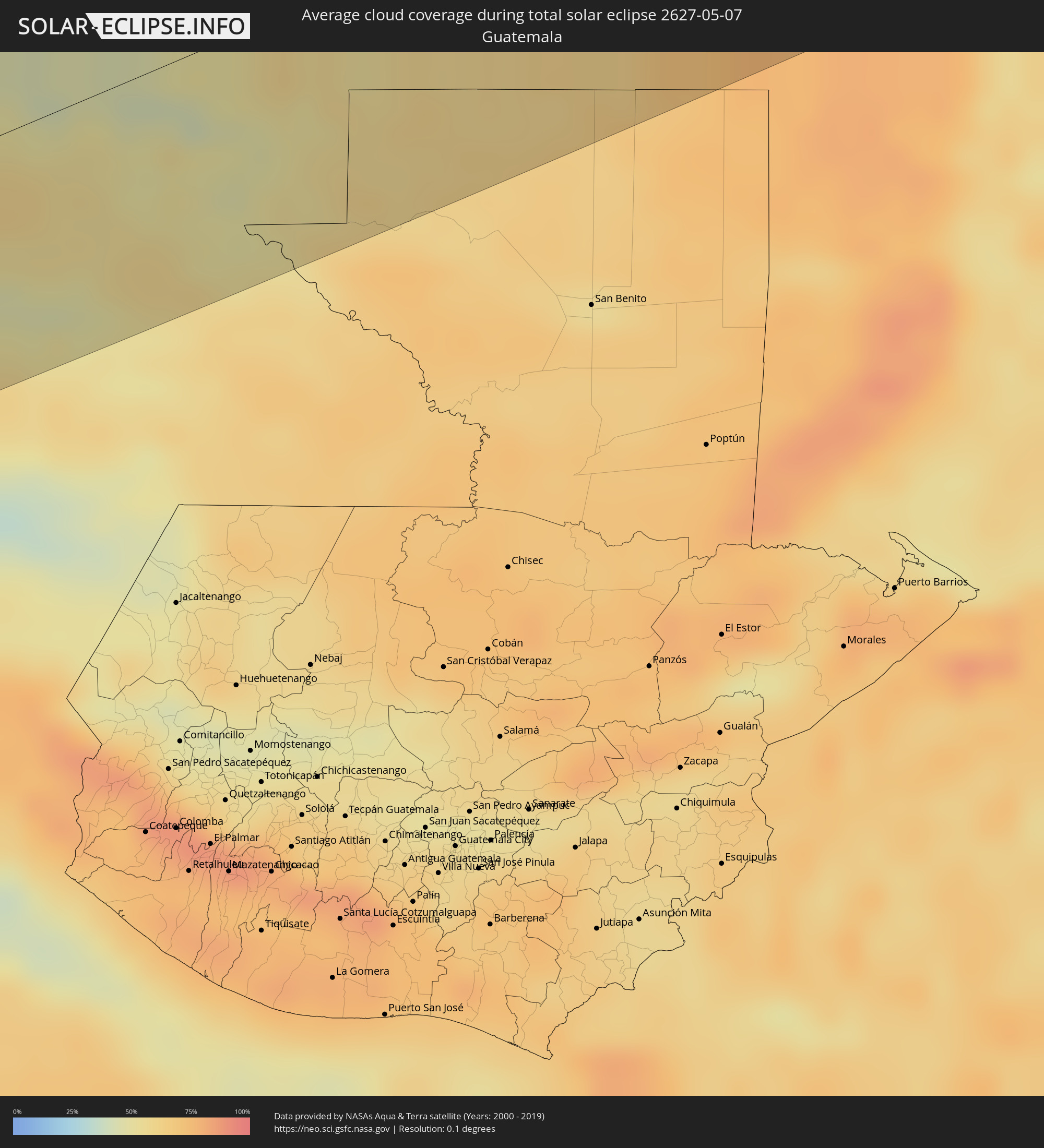 Guatemala
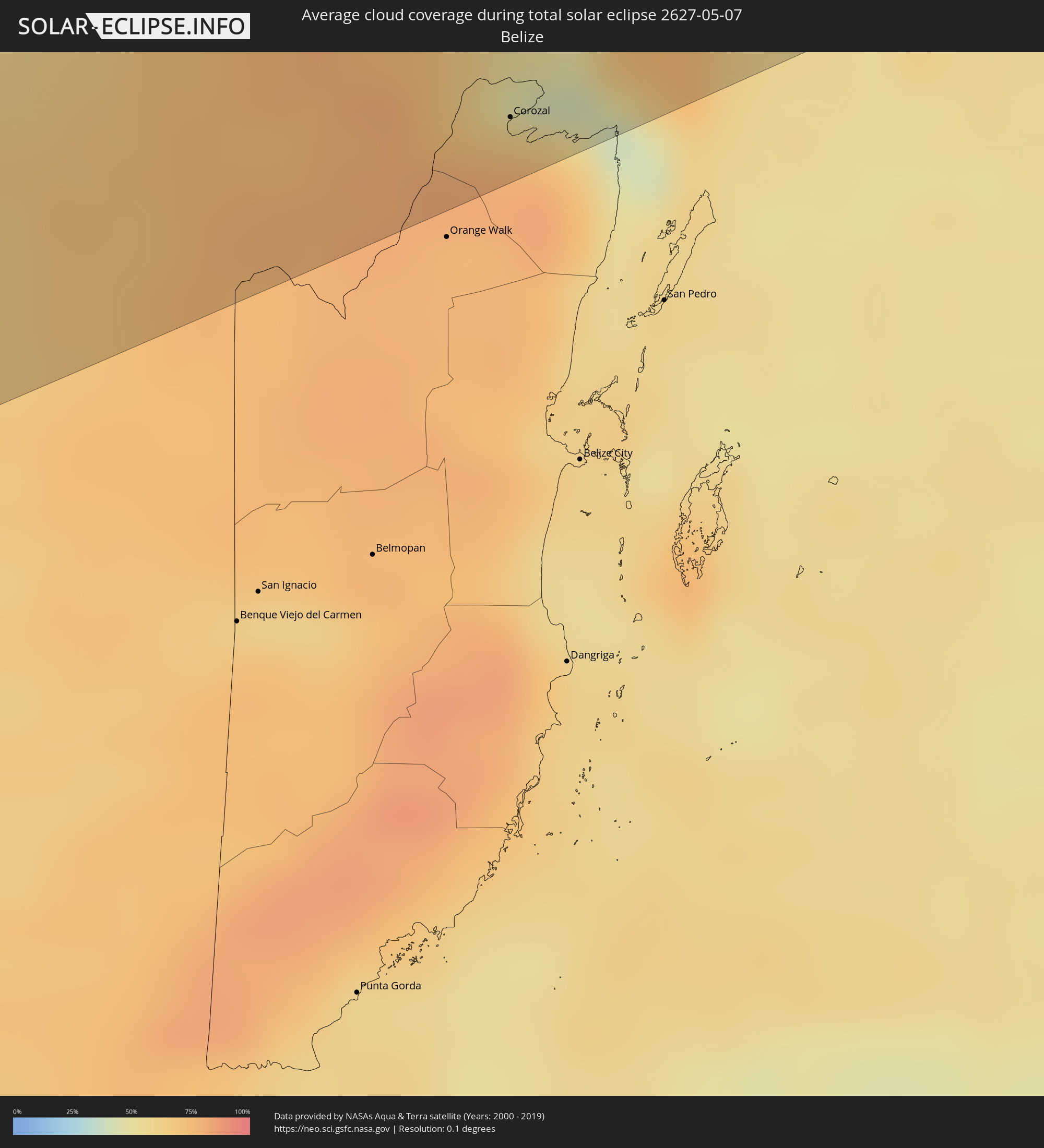 Belize
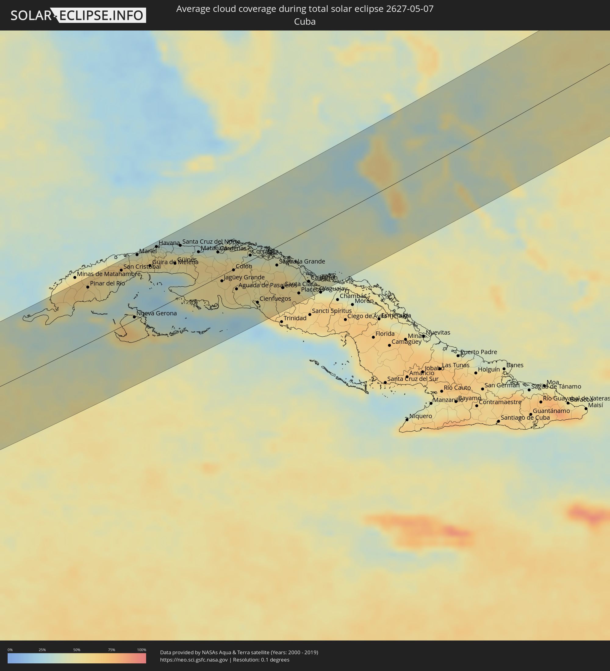 Kuba
Kuba
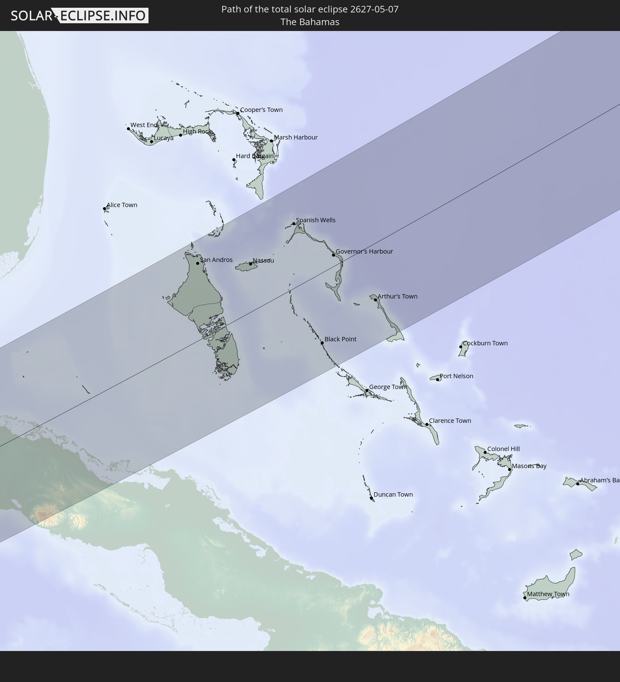
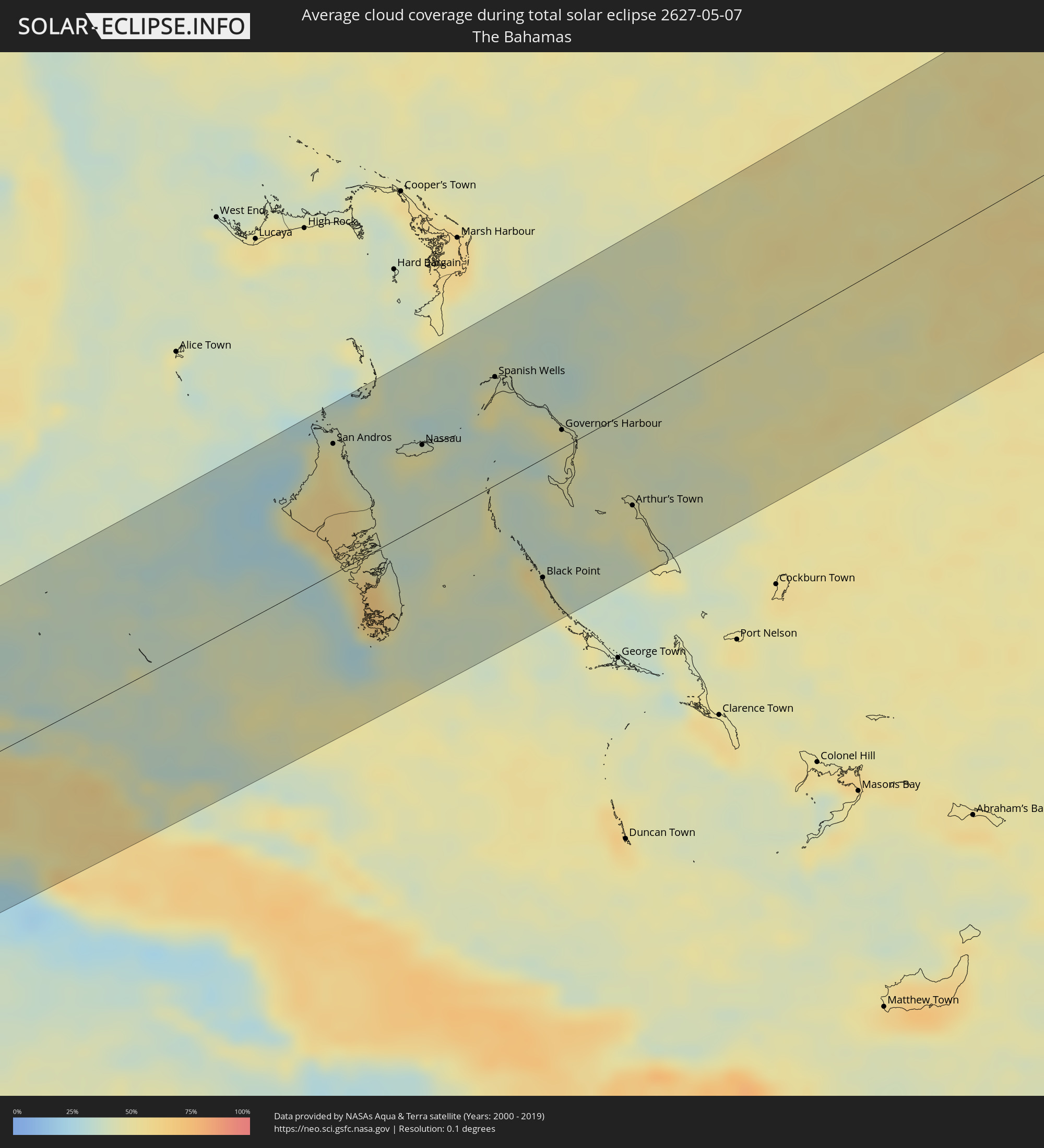 Bahamas
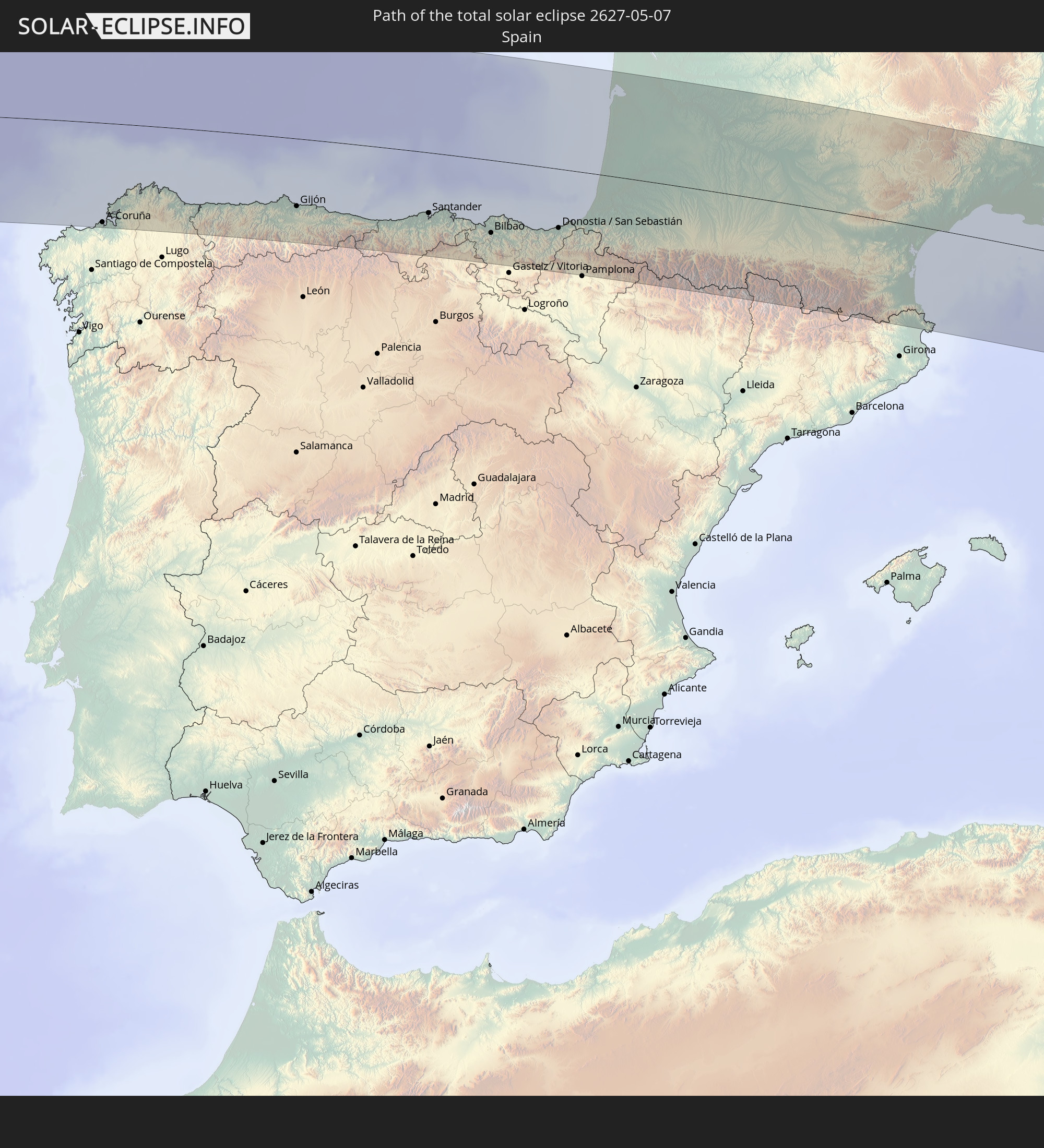
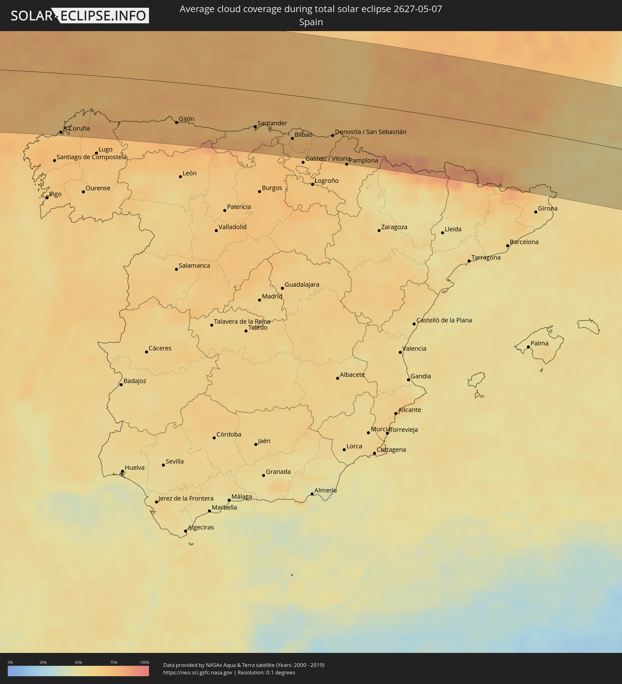 Spanien
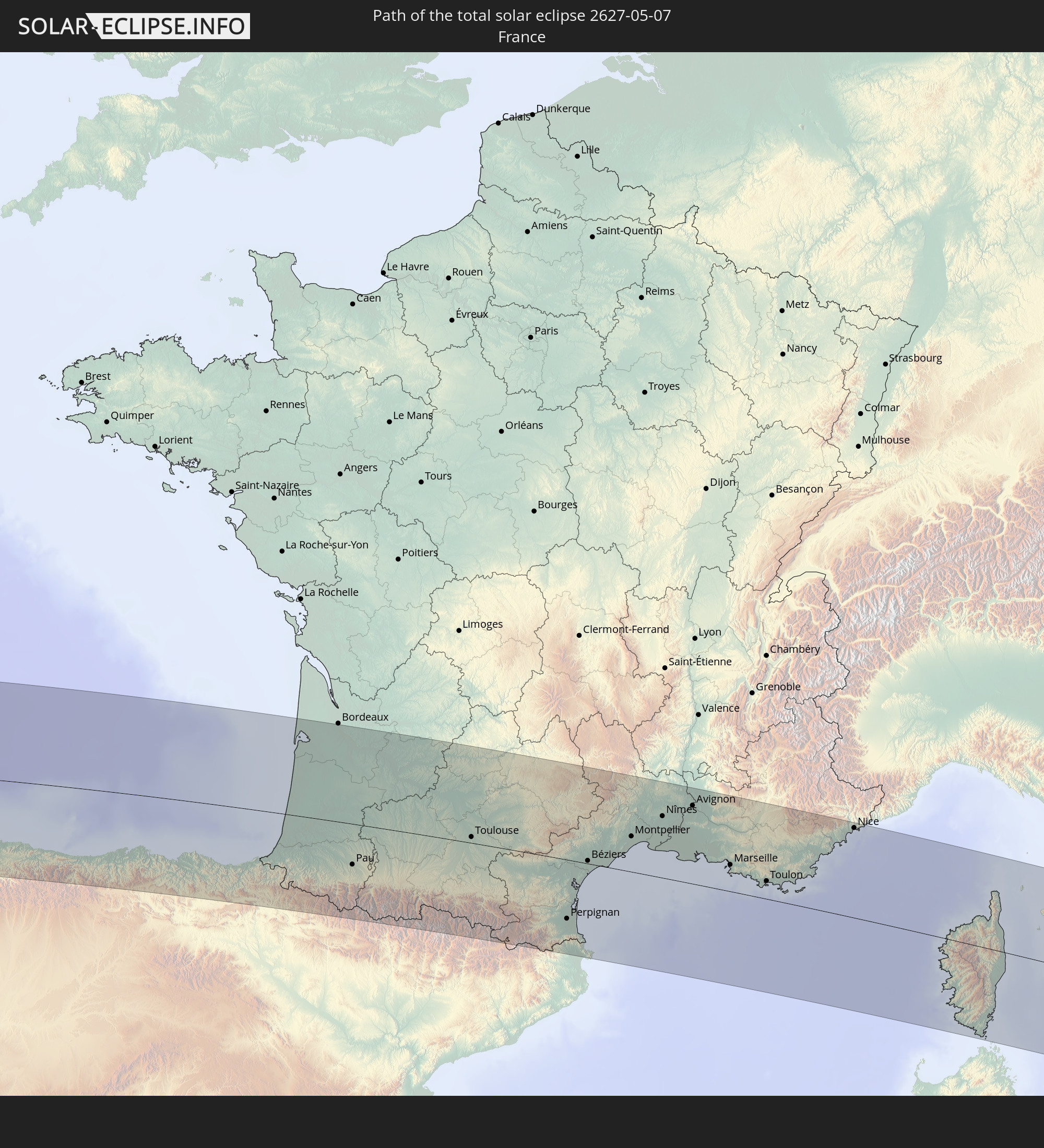
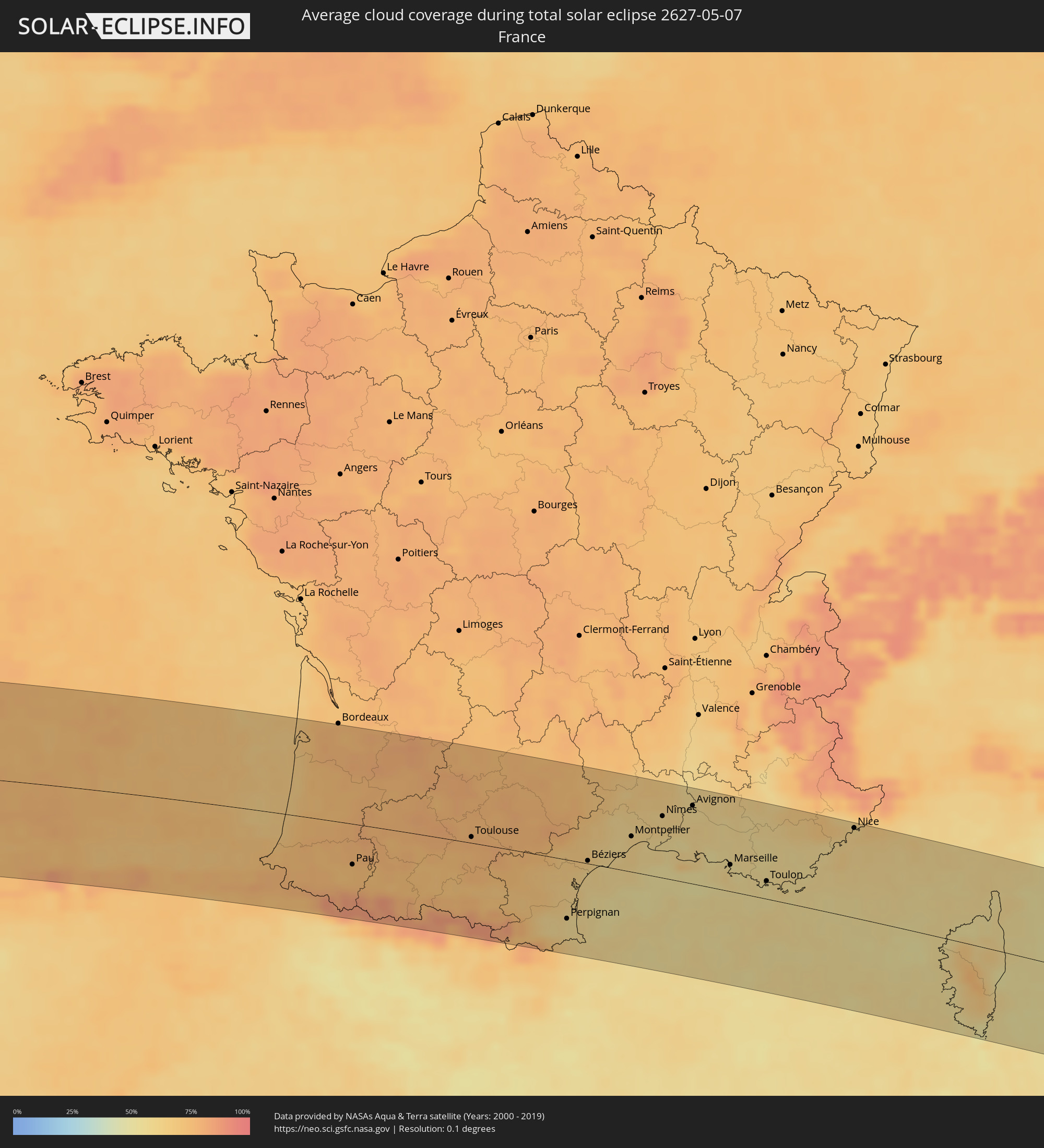 Frankreich
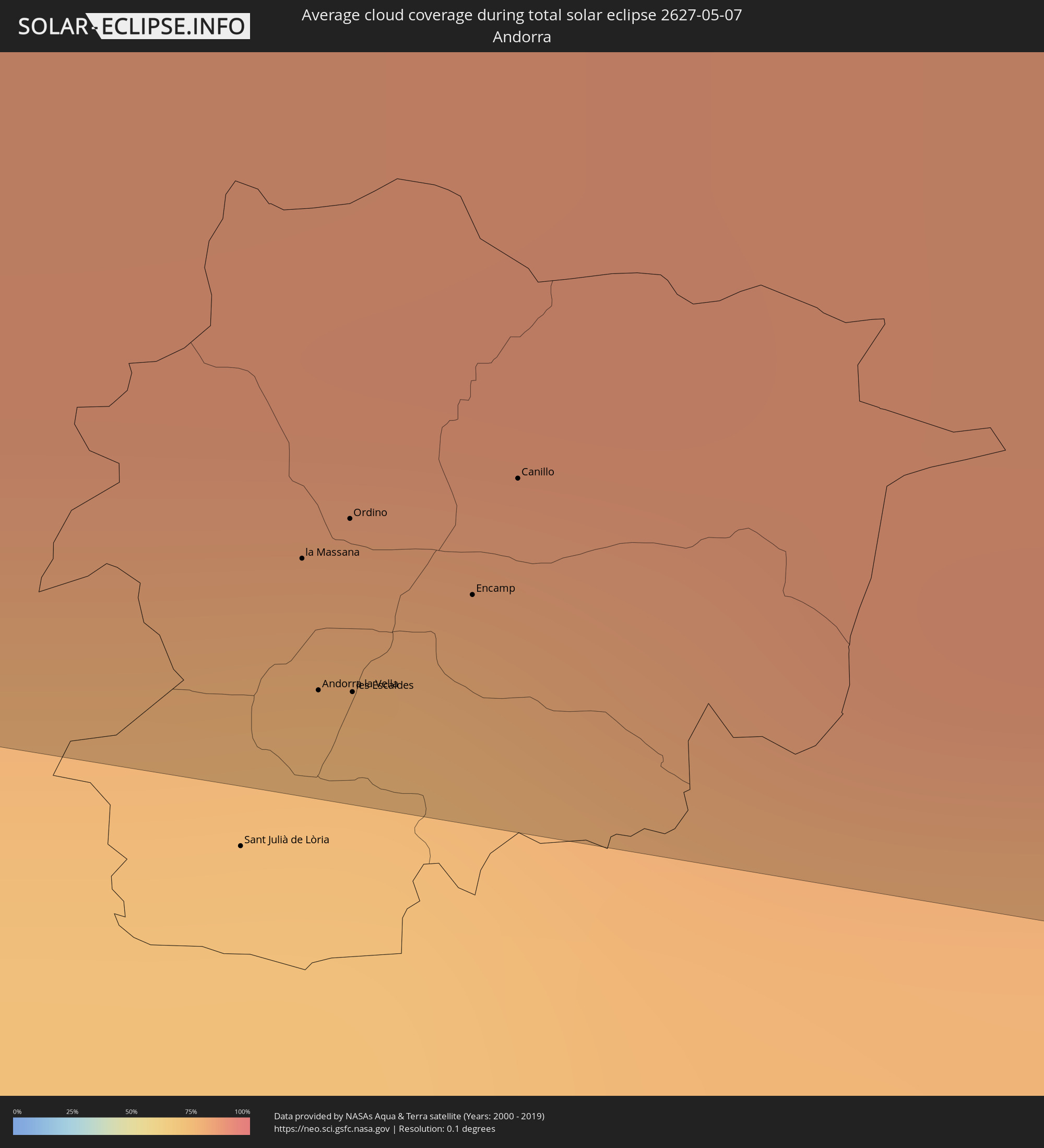 Andorra
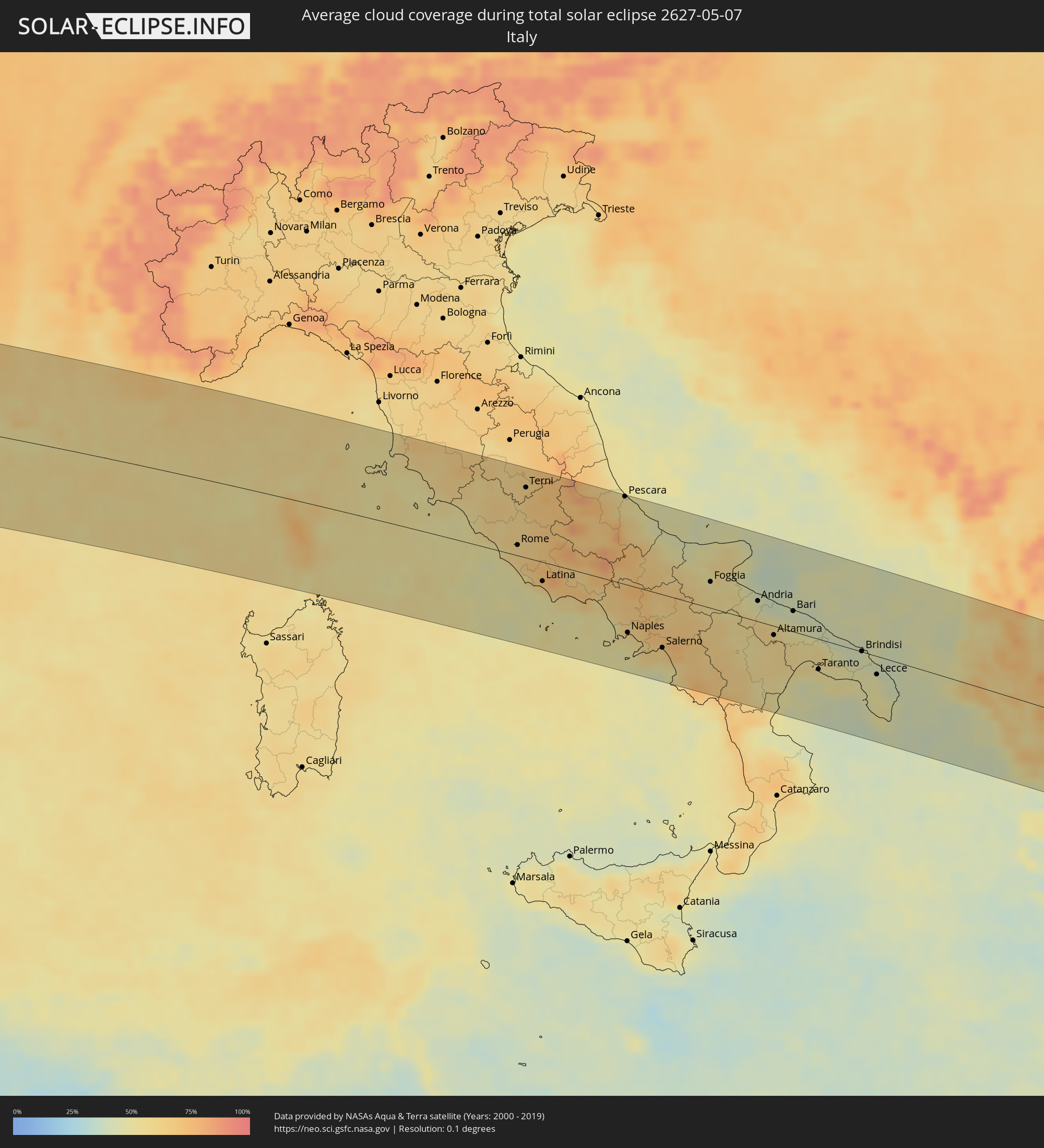 Italien
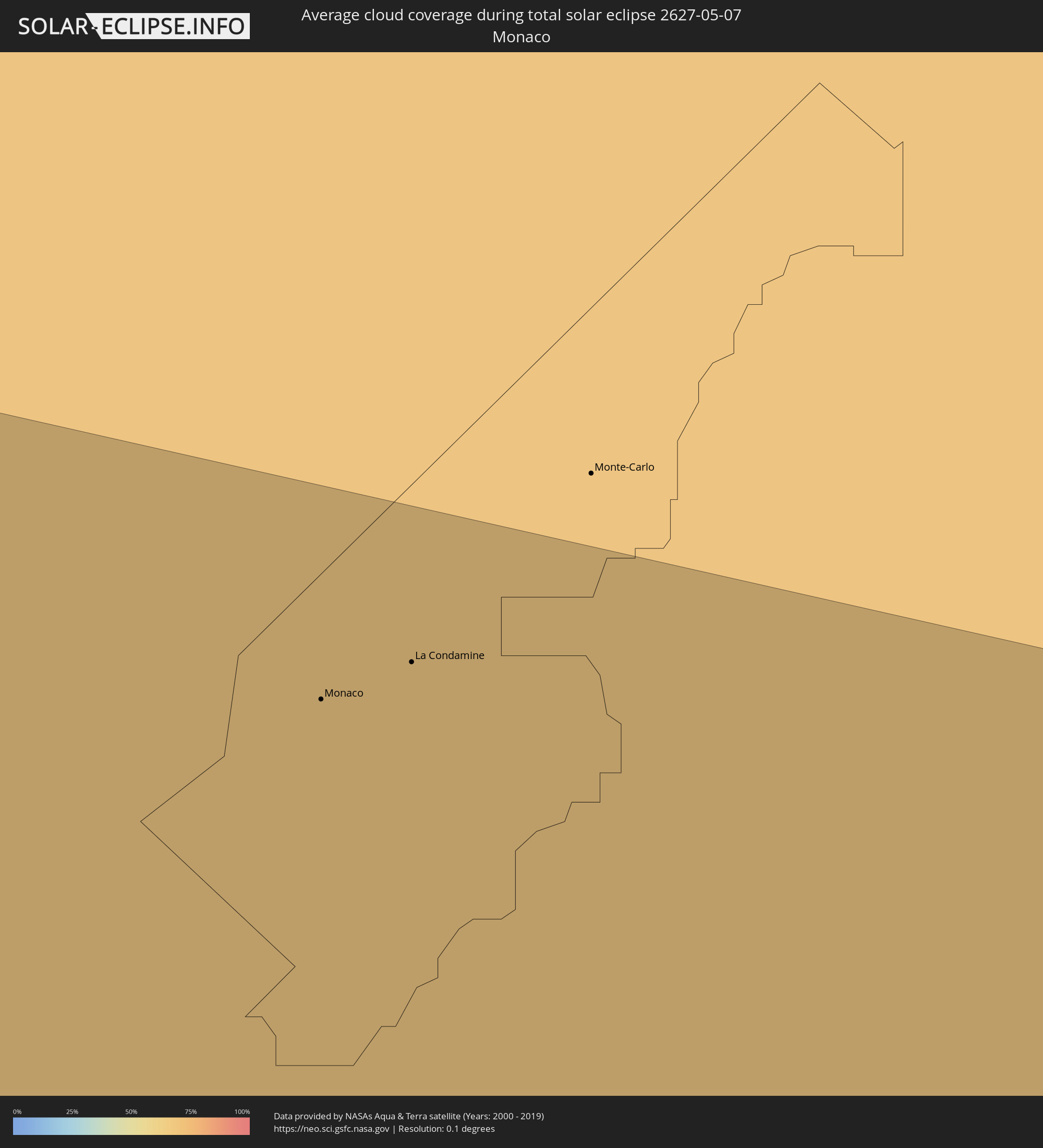 Monaco
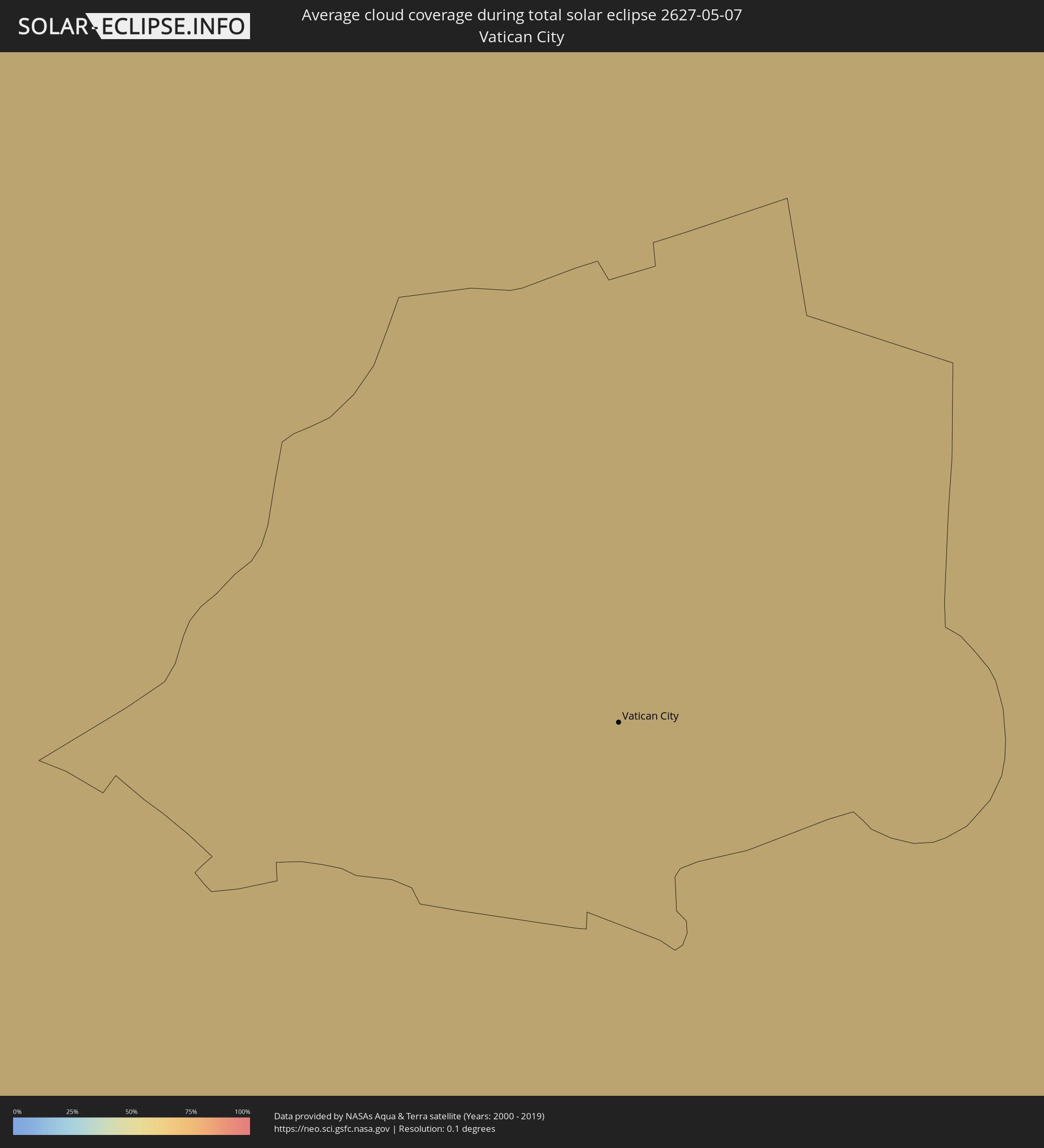 Vatikanstadt
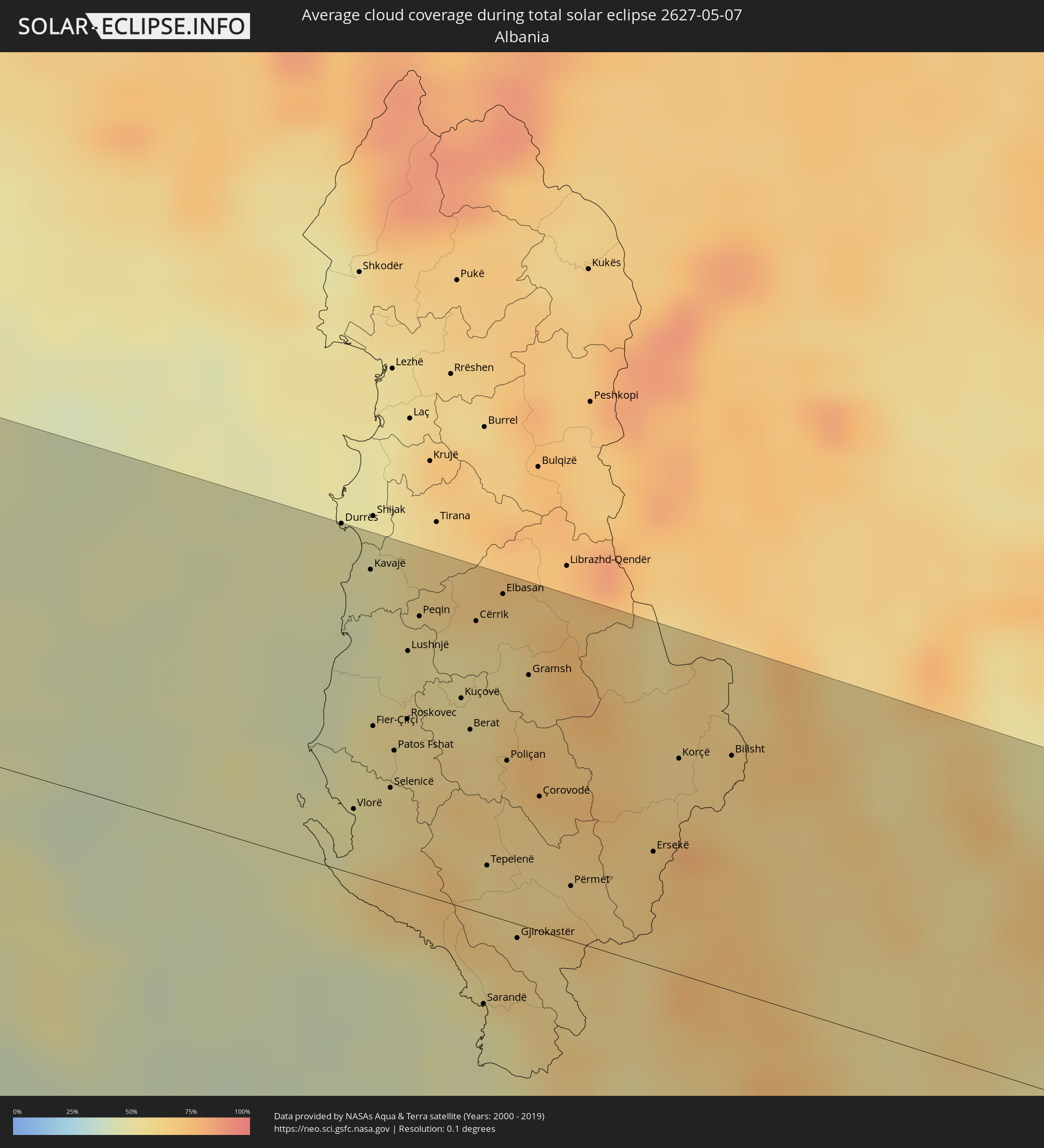 Albanien
 Griechenland
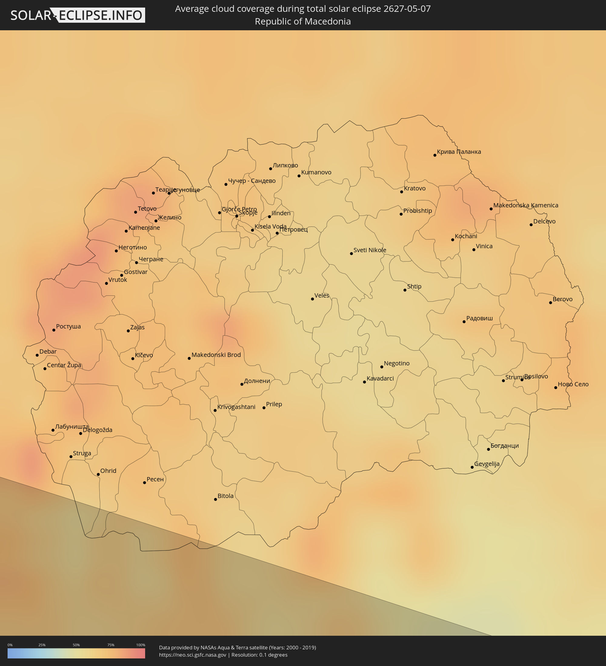 Mazedonien
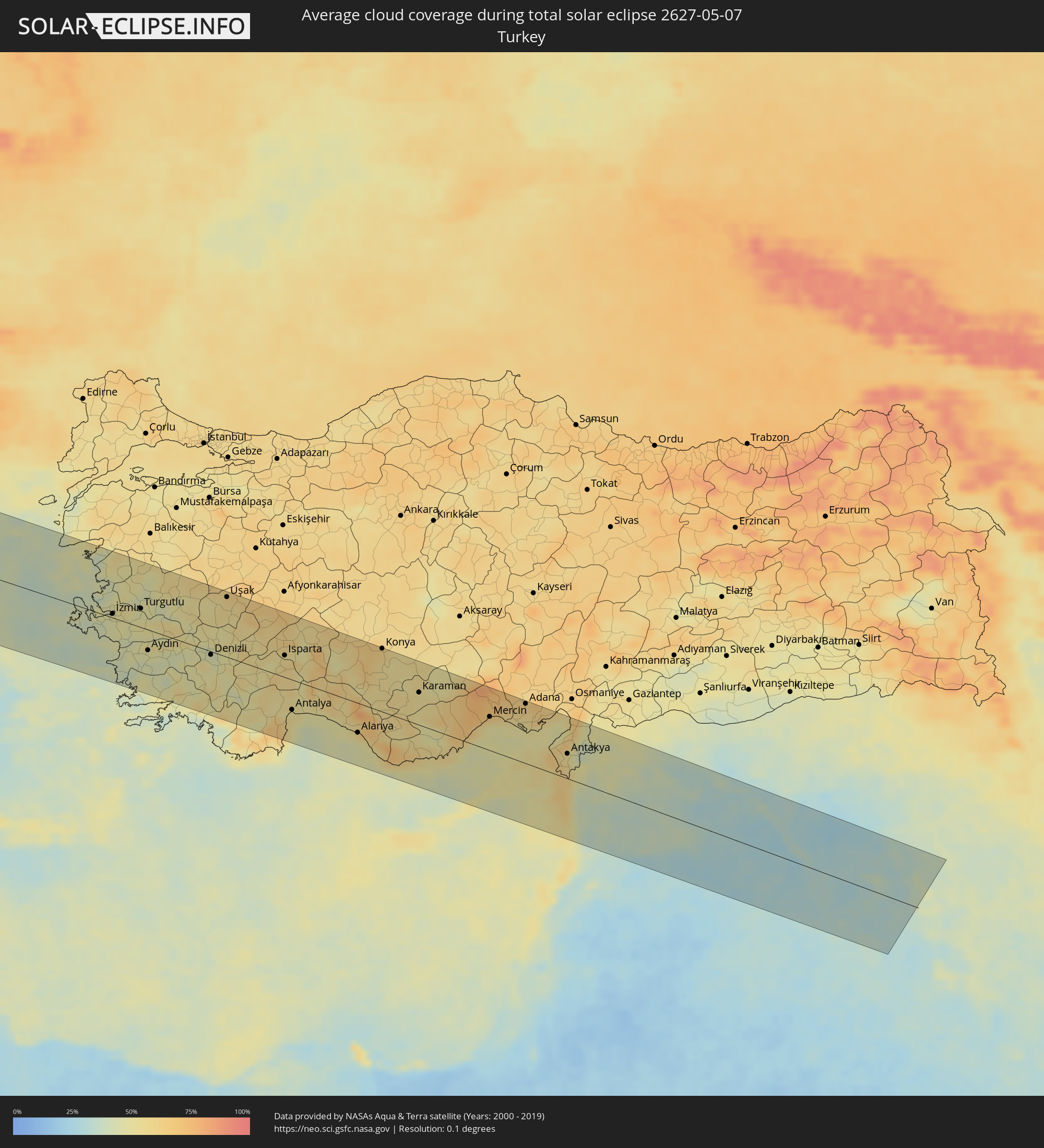 Türkei
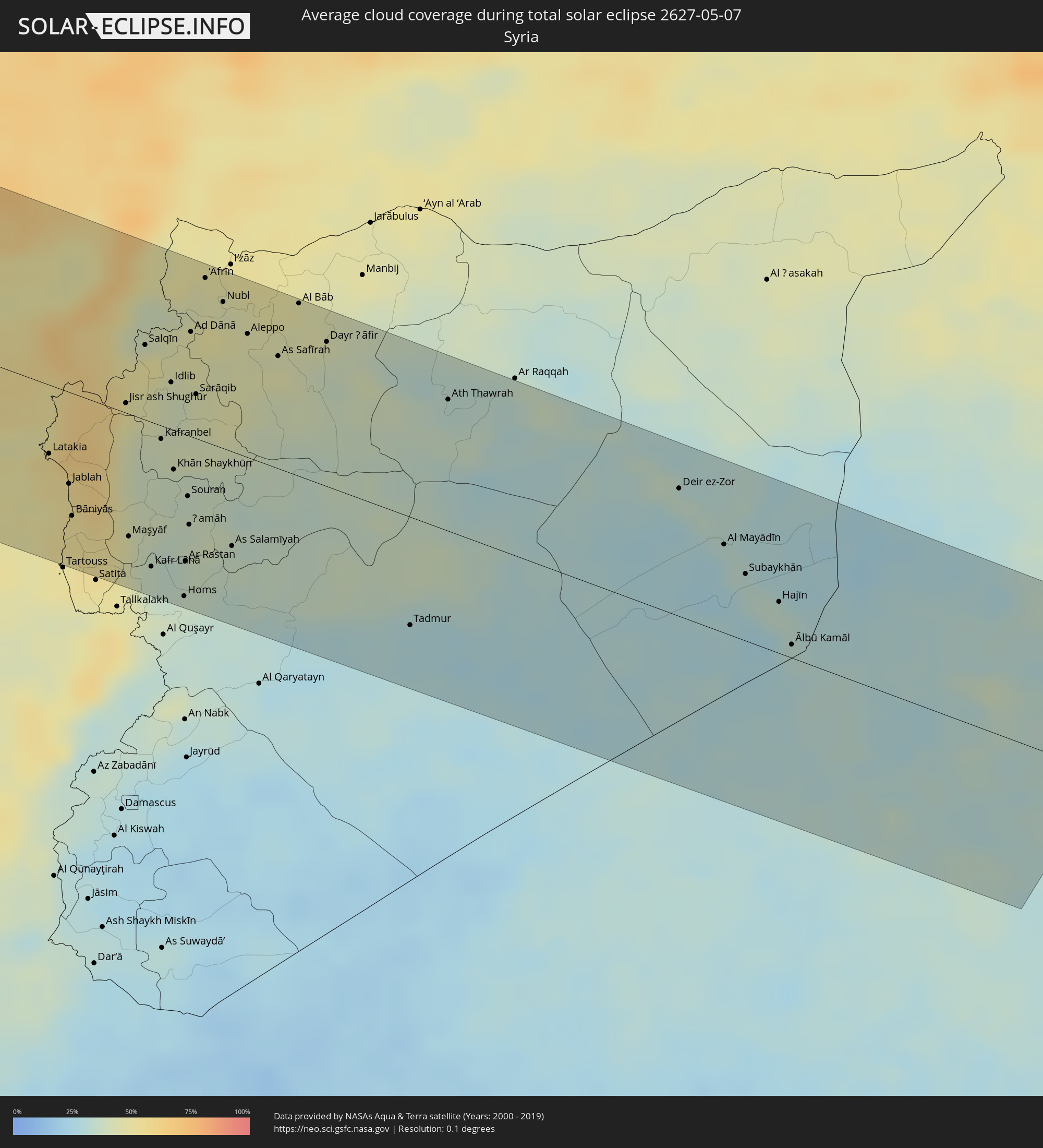 Syrien
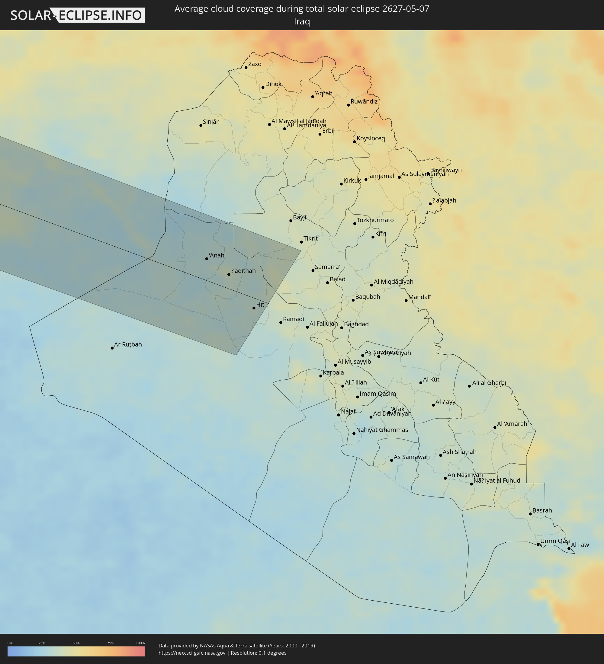 Irak
Irak
Orte im Finsternispfad
Die nachfolgene Tabelle zeigt Städte und Orte mit mehr als 5.000 Einwohnern, die sich im Finsternispfad befinden. Städte mit mehr als 100.000 Einwohnern sind dick gekennzeichnet. Mit einem Klick auf den Ort öffnet sich eine Detailkarte die die Lage des jeweiligen Ortes zusammen mit dem Verlauf der zentralen Finsternis präsentiert.
| Ort | Typ | Dauer der Verfinsterung | Ortszeit bei maximaler Verfinsterung | Entfernung zur Zentrallinie | Ø Bewölkung |
|
Santa Cruz Xoxocotlán, Oaxaca
|
total | - | 06:46:45 UTC-06:00 | 107 km | 30% |
|
Salina Cruz, Oaxaca
|
total | - | 06:45:55 UTC-06:00 | 41 km | 46% |
|
Juchitán de Zaragoza, Oaxaca
|
total | - | 06:46:11 UTC-06:00 | 22 km | 43% |
|
Las Choapas, Veracruz
|
total | - | 06:47:48 UTC-06:00 | 94 km | 57% |
|
Cárdenas, Tabasco
|
total | - | 06:47:58 UTC-06:00 | 74 km | 54% |
|
Comalcalco, Tabasco
|
total | - | 06:48:16 UTC-06:00 | 95 km | 54% |
|
Tuxtla, Chiapas
|
total | - | 06:46:40 UTC-06:00 | 64 km | 47% |
|
Villahermosa, Tabasco
|
total | - | 06:48:00 UTC-06:00 | 55 km | 52% |
|
San Cristóbal de las Casas, Chiapas
|
total | - | 06:46:41 UTC-06:00 | 86 km | 63% |
|
Ciudad del Carmen, Campeche
|
total | - | 06:48:53 UTC-06:00 | 77 km | 30% |
|
Corozal, Corozal
|
total | - | 06:49:20 UTC-06:00 | 95 km | 65% |
|
Chetumal, Quintana Roo
|
total | - | 07:49:30 UTC-05:00 | 86 km | 44% |
|
Playa del Carmen, Quintana Roo
|
total | - | 07:52:22 UTC-05:00 | 73 km | 53% |
|
San Miguel de Cozumel, Quintana Roo
|
total | - | 07:52:16 UTC-05:00 | 55 km | 58% |
|
Pinar del Río, Pinar del Río
|
total | - | 07:55:59 UTC-05:00 | 99 km | 58% |
|
Consolación del Sur, Pinar del Río
|
total | - | 07:56:10 UTC-05:00 | 99 km | 57% |
|
Artemisa, Artemisa
|
total | - | 07:56:57 UTC-05:00 | 95 km | 48% |
|
Güira de Melena, Artemisa
|
total | - | 07:57:03 UTC-05:00 | 81 km | 46% |
|
Havana, La Habana
|
total | - | 07:57:34 UTC-05:00 | 109 km | 52% |
|
Arroyo Naranjo, La Habana
|
total | - | 07:57:27 UTC-05:00 | 93 km | 58% |
|
Güines, Mayabeque
|
total | - | 07:57:21 UTC-05:00 | 63 km | 44% |
|
Matanzas, Matanzas
|
total | - | 07:57:52 UTC-05:00 | 62 km | 55% |
|
Cárdenas, Matanzas
|
total | - | 07:58:04 UTC-05:00 | 44 km | 51% |
|
Colón, Matanzas
|
total | - | 07:57:49 UTC-05:00 | 2 km | 59% |
|
Cienfuegos, Cienfuegos
|
total | - | 07:57:18 UTC-05:00 | 80 km | 39% |
|
Sagua la Grande, Villa Clara
|
total | - | 07:58:24 UTC-05:00 | 33 km | 54% |
|
Santa Clara, Villa Clara
|
total | - | 07:57:56 UTC-05:00 | 77 km | 58% |
|
San Andros, North Andros
|
total | - | 08:02:51 UTC-05:00 | 92 km | 54% |
|
Nassau, New Providence
|
total | - | 08:03:20 UTC-05:00 | 56 km | 48% |
|
Spanish Wells, Spanish Wells
|
total | - | 08:04:28 UTC-05:00 | 76 km | 51% |
|
Black Point, Black Point
|
total | - | 13:02:40 UTC+00:00 | 84 km | 54% |
|
Governor’s Harbour, Central Eleuthera
|
total | - | 13:04:19 UTC+00:00 | 13 km | 46% |
|
Arthur’s Town, Cat Island
|
total | - | 08:03:58 UTC-05:00 | 68 km | 49% |
|
A Coruña, Galicia
|
total | - | 16:15:48 UTC+01:00 | 112 km | 68% |
|
Ferrol, Galicia
|
total | - | 16:15:56 UTC+01:00 | 99 km | 68% |
|
Avilés, Asturias
|
total | - | 16:18:54 UTC+01:00 | 76 km | 72% |
|
Oviedo, Asturias
|
total | - | 16:19:10 UTC+01:00 | 97 km | 76% |
|
Gijón, Asturias
|
total | - | 16:19:15 UTC+01:00 | 76 km | 73% |
|
Torrelavega, Cantabria
|
total | - | 16:21:23 UTC+01:00 | 83 km | 77% |
|
Santander, Cantabria
|
total | - | 16:21:35 UTC+01:00 | 68 km | 70% |
|
Castro-Urdiales, Cantabria
|
total | - | 16:22:21 UTC+01:00 | 72 km | 71% |
|
Bilbao, Basque Country
|
total | - | 16:22:48 UTC+01:00 | 82 km | 74% |
|
Durango, Basque Country
|
total | - | 16:23:13 UTC+01:00 | 89 km | 75% |
|
Zarautz, Basque Country
|
total | - | 16:23:39 UTC+01:00 | 72 km | 74% |
|
Donostia / San Sebastián, Basque Country
|
total | - | 16:23:51 UTC+01:00 | 66 km | 74% |
|
Irun, Basque Country
|
total | - | 16:24:02 UTC+01:00 | 61 km | 76% |
|
Mérignac, Nouvelle-Aquitaine
|
total | - | 16:23:54 UTC+01:00 | 116 km | 75% |
|
Pau, Nouvelle-Aquitaine
|
total | - | 16:25:38 UTC+01:00 | 49 km | 73% |
|
Toulouse, Occitania
|
total | - | 16:27:13 UTC+01:00 | 7 km | 77% |
|
la Massana, La Massana
|
total | - | 16:28:19 UTC+01:00 | 108 km | 72% |
|
Andorra la Vella, Andorra la Vella
|
total | - | 16:28:22 UTC+01:00 | 112 km | 72% |
|
Ordino, Ordino
|
total | - | 16:28:20 UTC+01:00 | 107 km | 78% |
|
les Escaldes, Escaldes-Engordany
|
total | - | 16:28:23 UTC+01:00 | 112 km | 72% |
|
Encamp, Encamp
|
total | - | 16:28:24 UTC+01:00 | 108 km | 76% |
|
Canillo, Canillo
|
total | - | 16:28:23 UTC+01:00 | 104 km | 82% |
|
Perpignan, Occitania
|
total | - | 16:29:32 UTC+01:00 | 72 km | 56% |
|
Béziers, Occitania
|
total | - | 16:29:12 UTC+01:00 | 3 km | 59% |
|
Montpellier, Occitania
|
total | - | 16:29:33 UTC+01:00 | 43 km | 62% |
|
Nîmes, Occitania
|
total | - | 16:29:45 UTC+01:00 | 74 km | 61% |
|
Avignon, Provence-Alpes-Côte d'Azur
|
total | - | 16:30:02 UTC+01:00 | 94 km | 58% |
|
Marseille, Provence-Alpes-Côte d'Azur
|
total | - | 16:31:12 UTC+01:00 | 32 km | 56% |
|
Aix-en-Provence, Provence-Alpes-Côte d'Azur
|
total | - | 16:31:02 UTC+01:00 | 59 km | 57% |
|
Toulon, Provence-Alpes-Côte d'Azur
|
total | - | 16:31:52 UTC+01:00 | 22 km | 54% |
|
Antibes, Provence-Alpes-Côte d'Azur
|
total | - | 16:32:23 UTC+01:00 | 91 km | 61% |
|
Nice, Provence-Alpes-Côte d'Azur
|
total | - | 16:32:21 UTC+01:00 | 108 km | 63% |
|
Monaco
|
total | - | 16:32:26 UTC+01:00 | 114 km | 64% |
|
La Condamine
|
total | - | 16:32:26 UTC+01:00 | 114 km | 64% |
|
Acilia-Castel Fusano-Ostia Antica, Latium
|
total | - | 16:38:05 UTC+01:00 | 4 km | 51% |
|
Vatican City
|
total | - | 16:38:00 UTC+01:00 | 13 km | 60% |
|
Rome, Latium
|
total | - | 16:38:03 UTC+01:00 | 13 km | 60% |
|
Terni, Umbria
|
total | - | 16:37:24 UTC+01:00 | 88 km | 63% |
|
Latina, Latium
|
total | - | 16:38:46 UTC+01:00 | 24 km | 59% |
|
Pescara, Abruzzo
|
total | - | 16:38:27 UTC+01:00 | 110 km | 53% |
|
Naples, Campania
|
total | - | 16:40:14 UTC+01:00 | 61 km | 55% |
|
Salerno, Campania
|
total | - | 16:40:44 UTC+01:00 | 68 km | 61% |
|
Foggia, Apulia
|
total | - | 16:40:18 UTC+01:00 | 33 km | 53% |
|
Andria, Apulia
|
total | - | 16:40:56 UTC+01:00 | 26 km | 49% |
|
Bari, Apulia
|
total | - | 16:41:21 UTC+01:00 | 26 km | 43% |
|
Taranto, Apulia
|
total | - | 16:42:17 UTC+01:00 | 39 km | 52% |
|
Brindisi, Apulia
|
total | - | 16:42:23 UTC+01:00 | 1 km | 44% |
|
Lecce, Apulia
|
total | - | 16:42:47 UTC+01:00 | 23 km | 46% |
|
Durrës, Durrës
|
total | - | 16:42:16 UTC+01:00 | 111 km | 48% |
|
Vlorë, Vlorë
|
total | - | 16:43:14 UTC+01:00 | 21 km | 51% |
|
Kavajë, Tiranë
|
total | - | 16:42:28 UTC+01:00 | 99 km | 51% |
|
Fier-Çifçi, Fier
|
total | - | 16:42:59 UTC+01:00 | 49 km | 54% |
|
Lushnjë, Fier
|
total | - | 16:42:48 UTC+01:00 | 77 km | 55% |
|
Corfu, Ionian Islands
|
total | - | 17:44:18 UTC+02:00 | 58 km | 42% |
|
Berat, Berat
|
total | - | 16:43:09 UTC+01:00 | 58 km | 59% |
|
Sarandë, Vlorë
|
total | - | 16:44:04 UTC+01:00 | 29 km | 48% |
|
Tepelenë, Gjirokastër
|
total | - | 16:43:37 UTC+01:00 | 16 km | 58% |
|
Elbasan, Elbasan
|
total | - | 16:42:45 UTC+01:00 | 104 km | 60% |
|
Gjirokastër, Gjirokastër
|
total | - | 16:43:54 UTC+01:00 | 5 km | 63% |
|
Gramsh, Elbasan
|
total | - | 16:43:04 UTC+01:00 | 81 km | 62% |
|
Çorovodë, Berat
|
total | - | 16:43:29 UTC+01:00 | 43 km | 61% |
|
Korçë, Korçë
|
total | - | 16:43:34 UTC+01:00 | 69 km | 62% |
|
Ioánnina, Epirus
|
total | - | 17:44:37 UTC+02:00 | 30 km | 62% |
|
Ptolemaḯda, West Macedonia
|
total | - | 17:43:59 UTC+02:00 | 81 km | 57% |
|
Tríkala, Thessaly
|
total | - | 17:45:03 UTC+02:00 | 18 km | 50% |
|
Kozáni, West Macedonia
|
total | - | 17:44:16 UTC+02:00 | 61 km | 58% |
|
Kardítsa, Thessaly
|
total | - | 17:45:18 UTC+02:00 | 34 km | 49% |
|
Véroia, Central Macedonia
|
total | - | 17:44:09 UTC+02:00 | 96 km | 55% |
|
Lárisa, Thessaly
|
total | - | 17:45:10 UTC+02:00 | 7 km | 47% |
|
Lamía, Central Greece
|
total | - | 17:45:57 UTC+02:00 | 70 km | 51% |
|
Kateríni, Central Macedonia
|
total | - | 17:44:31 UTC+02:00 | 77 km | 49% |
|
Vólos, Thessaly
|
total | - | 17:45:38 UTC+02:00 | 8 km | 52% |
|
Chalkída, Central Greece
|
total | - | 17:46:45 UTC+02:00 | 86 km | 45% |
|
Mytilíni, North Aegean
|
total | - | 17:46:47 UTC+02:00 | 63 km | 42% |
|
İzmir, İzmir
|
total | - | 18:47:36 UTC+03:00 | 6 km | 46% |
|
Manisa, Manisa
|
total | - | 18:47:27 UTC+03:00 | 35 km | 52% |
|
Aydın, Aydın
|
total | - | 18:48:18 UTC+03:00 | 34 km | 43% |
|
Denizli, Denizli
|
total | - | 18:48:32 UTC+03:00 | 5 km | 45% |
|
Uşak, Uşak
|
total | - | 18:47:40 UTC+03:00 | 98 km | 59% |
|
Isparta, Isparta
|
total | - | 18:48:41 UTC+03:00 | 36 km | 57% |
|
Antalya, Antalya
|
total | - | 18:49:32 UTC+03:00 | 50 km | 53% |
|
Konya, Konya
|
total | - | 18:48:41 UTC+03:00 | 104 km | 60% |
|
Rizokárpaso, Ammochostos
|
total | - | 17:50:50 UTC+02:00 | 77 km | 50% |
|
Mercin, Mersin
|
total | - | 18:49:43 UTC+03:00 | 56 km | 55% |
|
Tarsus, Mersin
|
total | - | 18:49:35 UTC+03:00 | 77 km | 58% |
|
Adana, Adana
|
total | - | 18:49:29 UTC+03:00 | 99 km | 60% |
|
Latakia, Latakia
|
total | - | 17:50:49 UTC+02:00 | 40 km | 54% |
|
Jablah, Latakia
|
total | - | 17:50:58 UTC+02:00 | 54 km | 53% |
|
Antakya, Hatay
|
total | - | 18:50:11 UTC+03:00 | 42 km | 55% |
|
İskenderun, Hatay
|
total | - | 18:49:49 UTC+03:00 | 82 km | 64% |
|
Idlib, Idlib
|
total | - | 17:50:24 UTC+02:00 | 27 km | 41% |
|
Homs, Homs
|
total | - | 17:51:28 UTC+02:00 | 96 km | 36% |
|
Ḩamāh, Hama
|
total | - | 17:51:06 UTC+02:00 | 52 km | 39% |
|
As Salamīyah, Hama
|
total | - | 17:51:11 UTC+02:00 | 56 km | 37% |
|
Aleppo, Aleppo
|
total | - | 17:50:06 UTC+02:00 | 72 km | 44% |
|
As Safīrah, Aleppo
|
total | - | 17:50:11 UTC+02:00 | 66 km | 45% |
|
Al Bāb, Aleppo
|
total | - | 17:49:54 UTC+02:00 | 101 km | 47% |
|
Ath Thawrah, Ar-Raqqah
|
total | - | 17:50:16 UTC+02:00 | 77 km | 36% |
|
Deir ez-Zor, Deir ez-Zor
|
total | - | 17:50:28 UTC+02:00 | 75 km | 28% |
|
Al Mayādīn, Deir ez-Zor
|
total | - | 17:50:41 UTC+02:00 | 52 km | 32% |
|
Ālbū Kamāl, Deir ez-Zor
|
total | - | 17:51:05 UTC+02:00 | 8 km | 31% |
|
Rāwah, Anbar
|
total | - | 18:50:51 UTC+03:00 | 43 km | 30% |
|
‘Anat al Qadīmah, Anbar
|
total | - | 18:50:51 UTC+03:00 | 42 km | 30% |
|
‘Anah, Anbar
|
total | - | 18:50:56 UTC+03:00 | 33 km | 33% |
|
Ḩadīthah, Anbar
|
total | - | 18:51:02 UTC+03:00 | 22 km | 34% |
|
Hīt, Anbar
|
total | - | 18:51:20 UTC+03:00 | 19 km | 32% |