Totale Sonnenfinsternis vom 29.05.2663
| Wochentag: | Freitag |
| Maximale Dauer der Verfinsterung: | 05m07s |
| Maximale Breite des Finsternispfades: | 276 km |
| Saroszyklus: | 148 |
| Bedeckungsgrad: | 100% |
| Magnitude: | 1.0719 |
| Gamma: | 0.5295 |
Wo kann man die Sonnenfinsternis vom 29.05.2663 sehen?
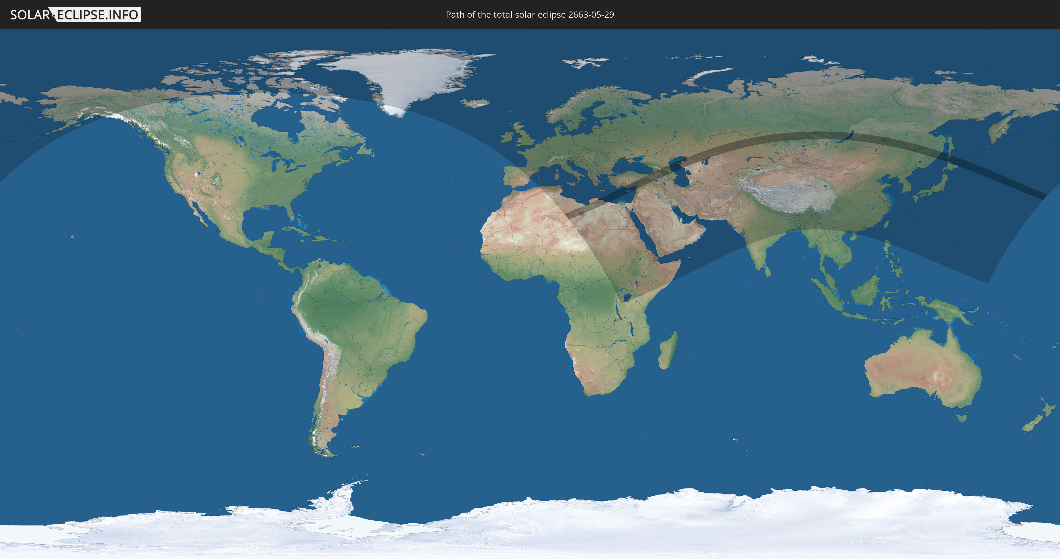
Die Sonnenfinsternis am 29.05.2663 kann man in 113 Ländern als partielle Sonnenfinsternis beobachten.
Der Finsternispfad verläuft durch 13 Länder. Nur in diesen Ländern ist sie als totale Sonnenfinsternis zu sehen.
In den folgenden Ländern ist die Sonnenfinsternis total zu sehen
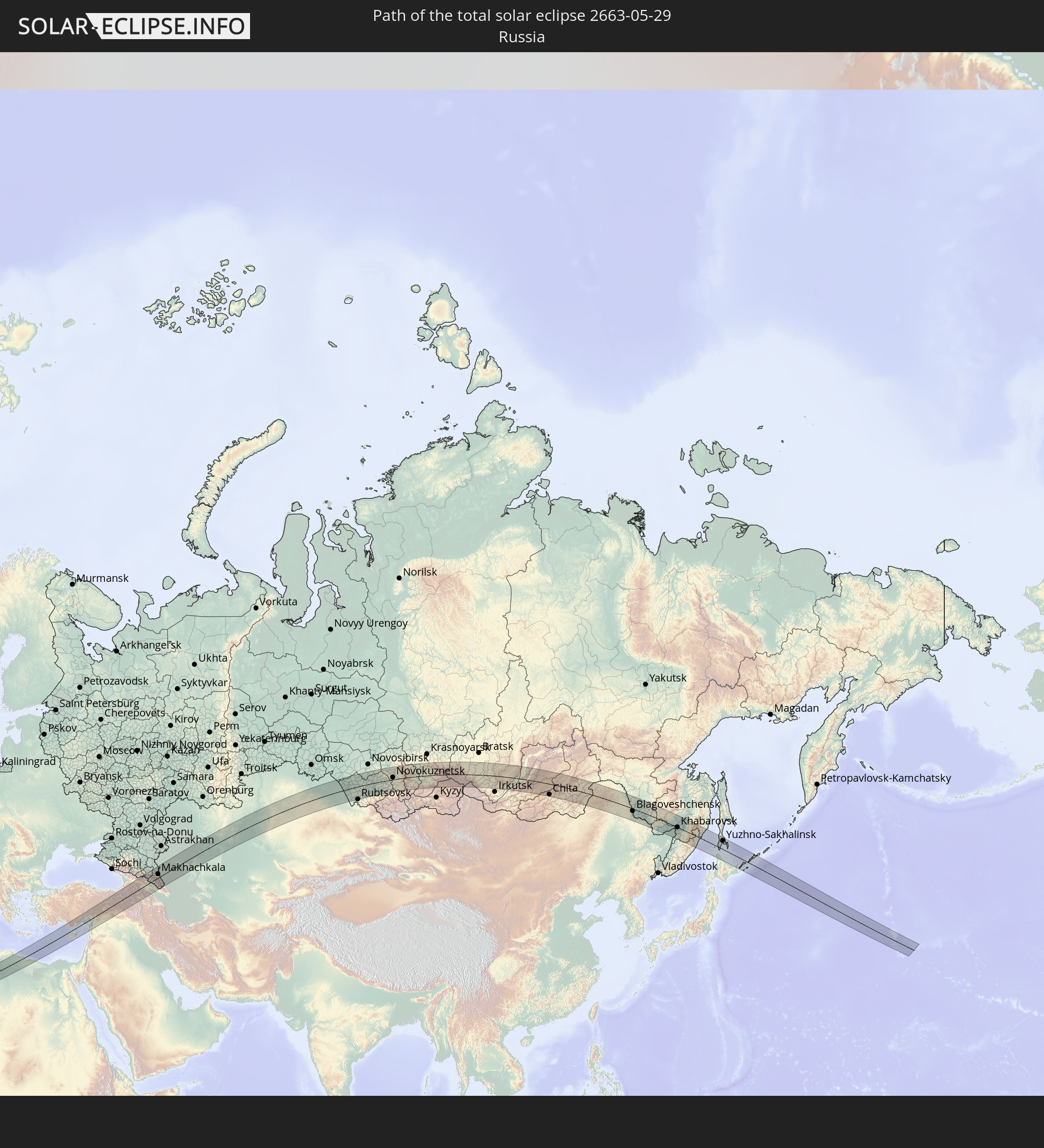 Russland
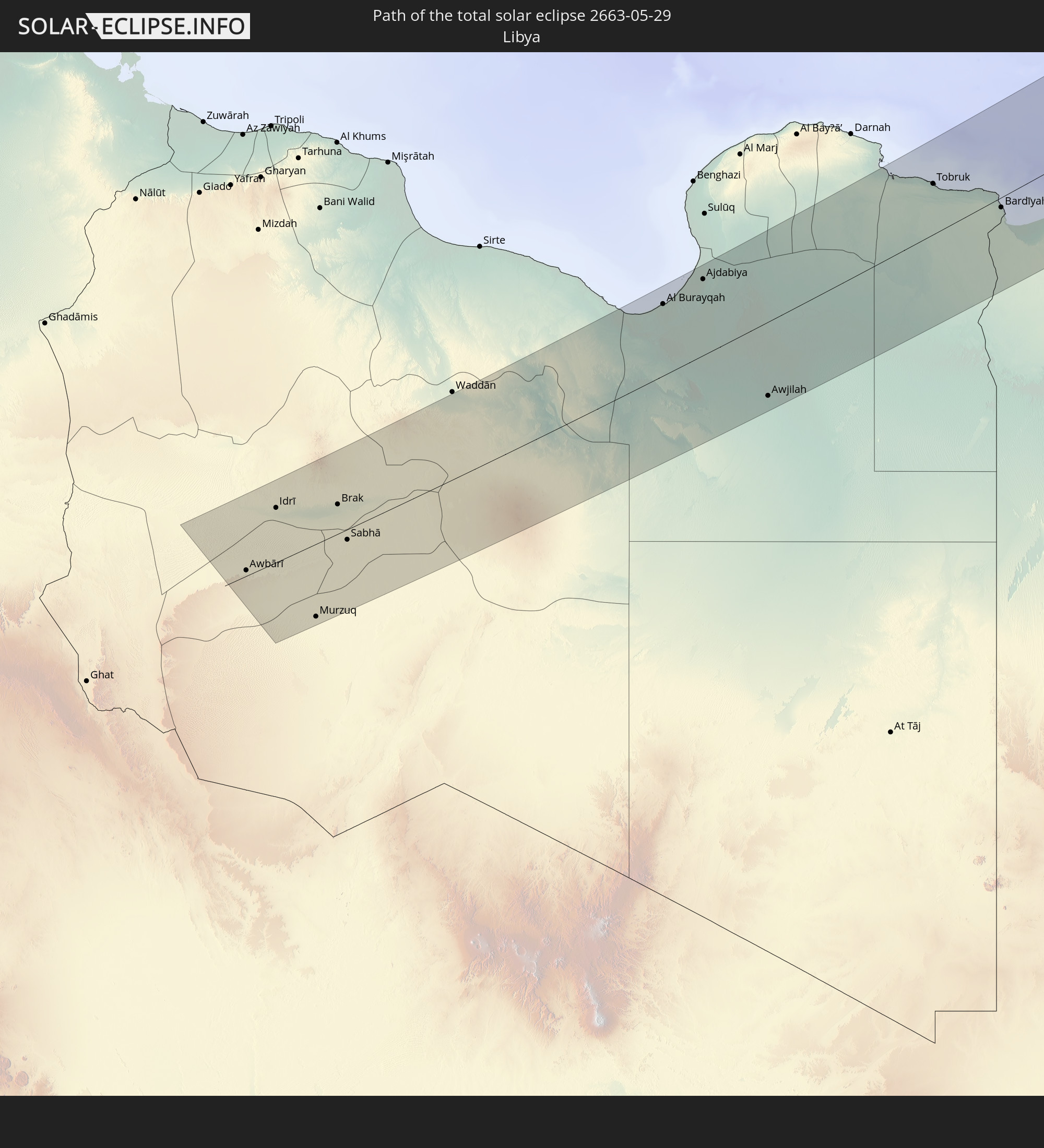 Libyen
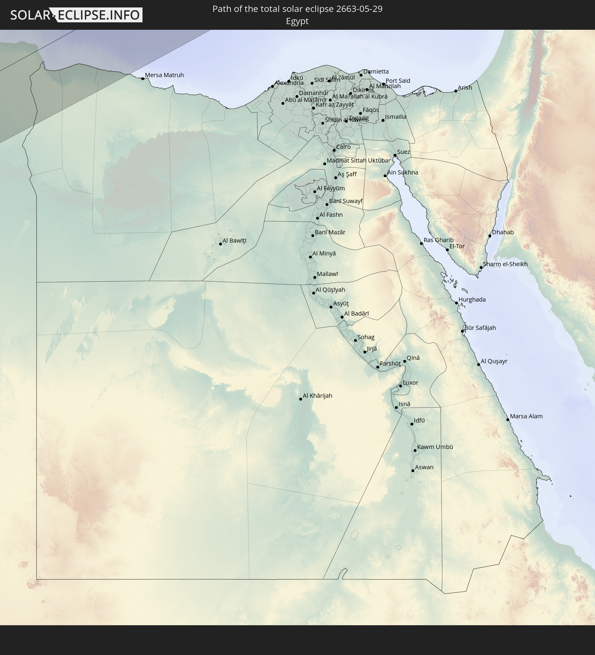 Ägypten
 Türkei
 Republik Zypern
 Syrien
 Georgien
 Armenien
 Aserbaidschan
 Kasachstan
 Usbekistan
 Volksrepublik China
 Japan
Japan
In den folgenden Ländern ist die Sonnenfinsternis partiell zu sehen
 Russland
 Vereinigte Staaten
 Kanada
 Grönland
 Island
 Spanien
 Irland
 Spitzbergen
 Algerien
 Vereinigtes Königreich
 Färöer
 Frankreich
 Isle of Man
 Guernsey
 Jersey
 Andorra
 Belgien
 Niederlande
 Norwegen
 Luxemburg
 Deutschland
 Schweiz
 Italien
 Monaco
 Tunesien
 Dänemark
 Libyen
 Liechtenstein
 Österreich
 Schweden
 Tschechien
 Demokratische Republik Kongo
 San Marino
 Vatikanstadt
 Slowenien
 Tschad
 Kroatien
 Polen
Polen
 Malta
Malta
 Zentralafrikanische Republik
 Bosnien und Herzegowina
 Ungarn
 Slowakei
 Montenegro
 Serbien
 Albanien
 Åland Islands
 Griechenland
 Rumänien
 Mazedonien
 Finnland
 Litauen
 Lettland
 Estland
 Sudan
Sudan
 Ukraine
 Bulgarien
 Weißrussland
 Ägypten
 Türkei
 Moldawien
 Ruanda
 Tansania
 Uganda
 Republik Zypern
 Äthiopien
 Kenia
Kenia
 Staat Palästina
 Israel
 Saudi-Arabien
 Jordanien
 Libanon
 Syrien
 Eritrea
 Irak
Irak
 Georgien
 Somalia
 Dschibuti
 Jemen
Jemen
 Armenien
 Iran
Iran
 Aserbaidschan
 Kasachstan
 Kuwait
 Bahrain
 Katar
Katar
 Vereinigte Arabische Emirate
 Oman
Oman
 Turkmenistan
 Usbekistan
 Afghanistan
 Pakistan
 Tadschikistan
 Indien
 Kirgisistan
 Volksrepublik China
 Nepal
Nepal
 Mongolei
 Bangladesch
 Bhutan
 Myanmar
 Laos
Laos
 Vietnam
 Macau
Macau
 Hongkong
 Taiwan
 Philippinen
 Japan
Japan
 Nordkorea
 Südkorea
 Föderierte Staaten von Mikronesien
 Guam
Guam
 Nördliche Marianen
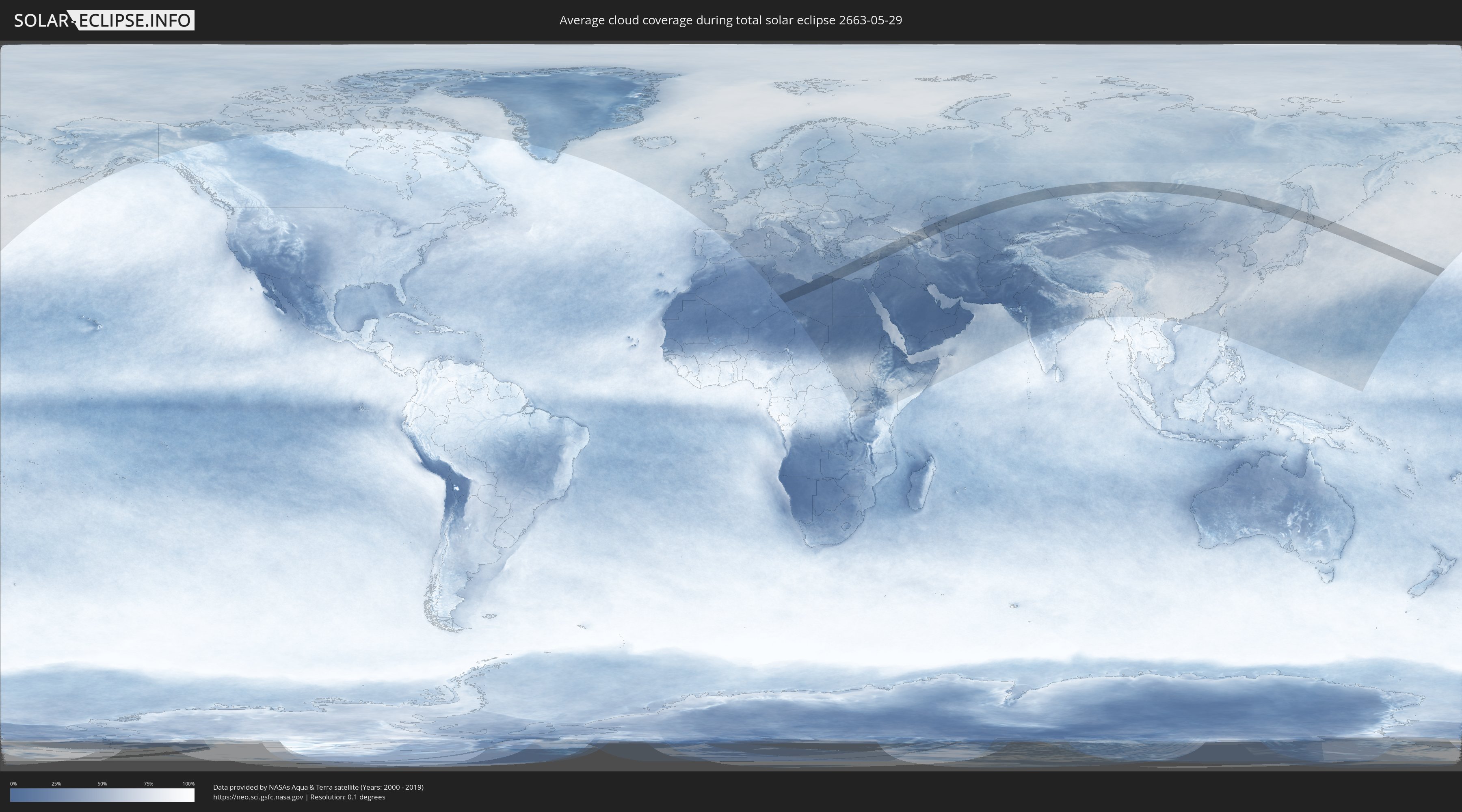
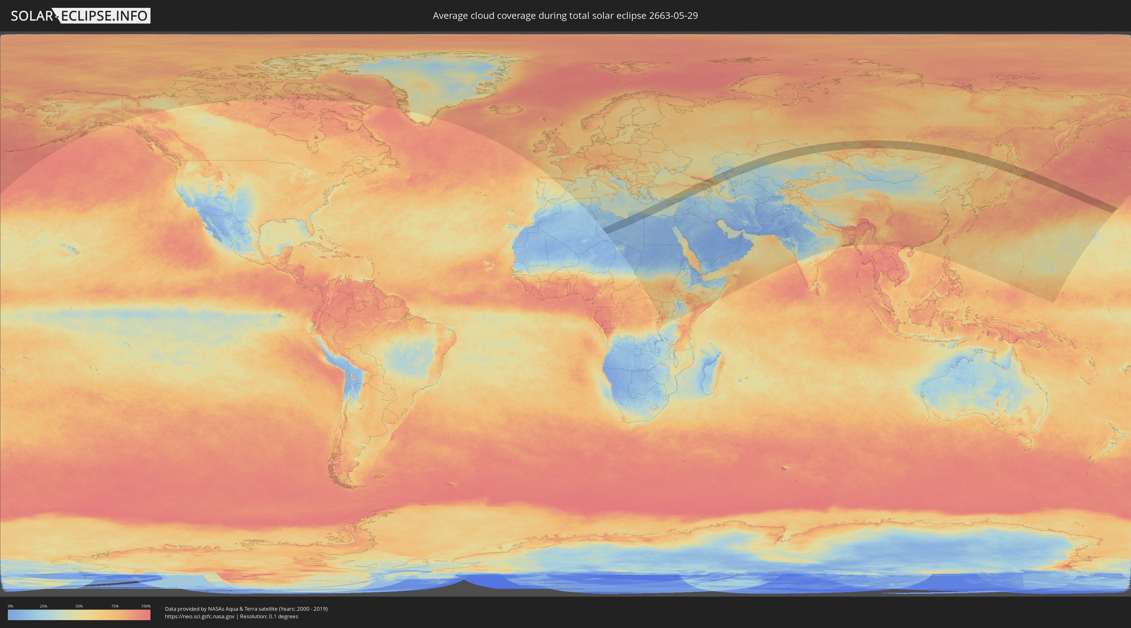
Wie wird das Wetter während der totalen Sonnenfinsternis am 29.05.2663?
Wo ist der beste Ort, um die totale Sonnenfinsternis vom 29.05.2663 zu beobachten?
Die folgenden Karten zeigen die durchschnittliche Bewölkung für den Tag, an dem die totale Sonnenfinsternis
stattfindet. Mit Hilfe der Karten lässt sich der Ort entlang des Finsternispfades eingrenzen,
der die besten Aussichen auf einen klaren wolkenfreien Himmel bietet.
Trotzdem muss man immer lokale Gegenenheiten beachten und sollte sich genau über das Wetter an seinem
gewählten Beobachtungsort informieren.
Die Daten stammen von den beiden NASA-Satelliten
AQUA und TERRA
und wurden über einen Zeitraum von 19 Jahren (2000 - 2019) gemittelt.
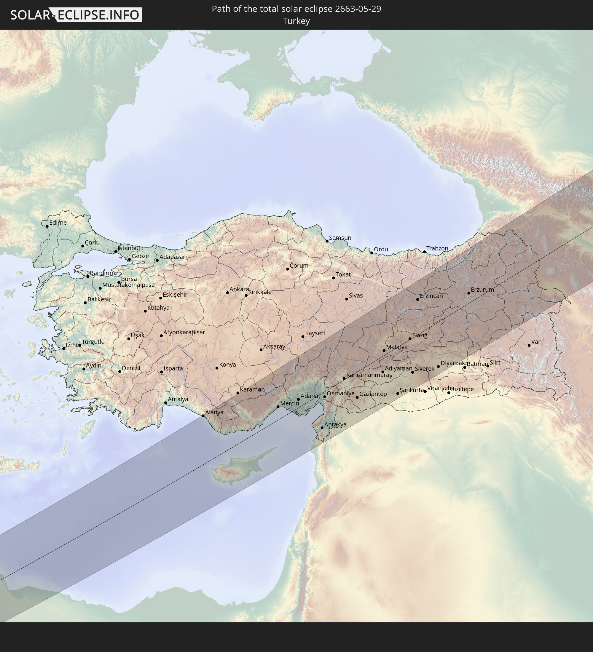
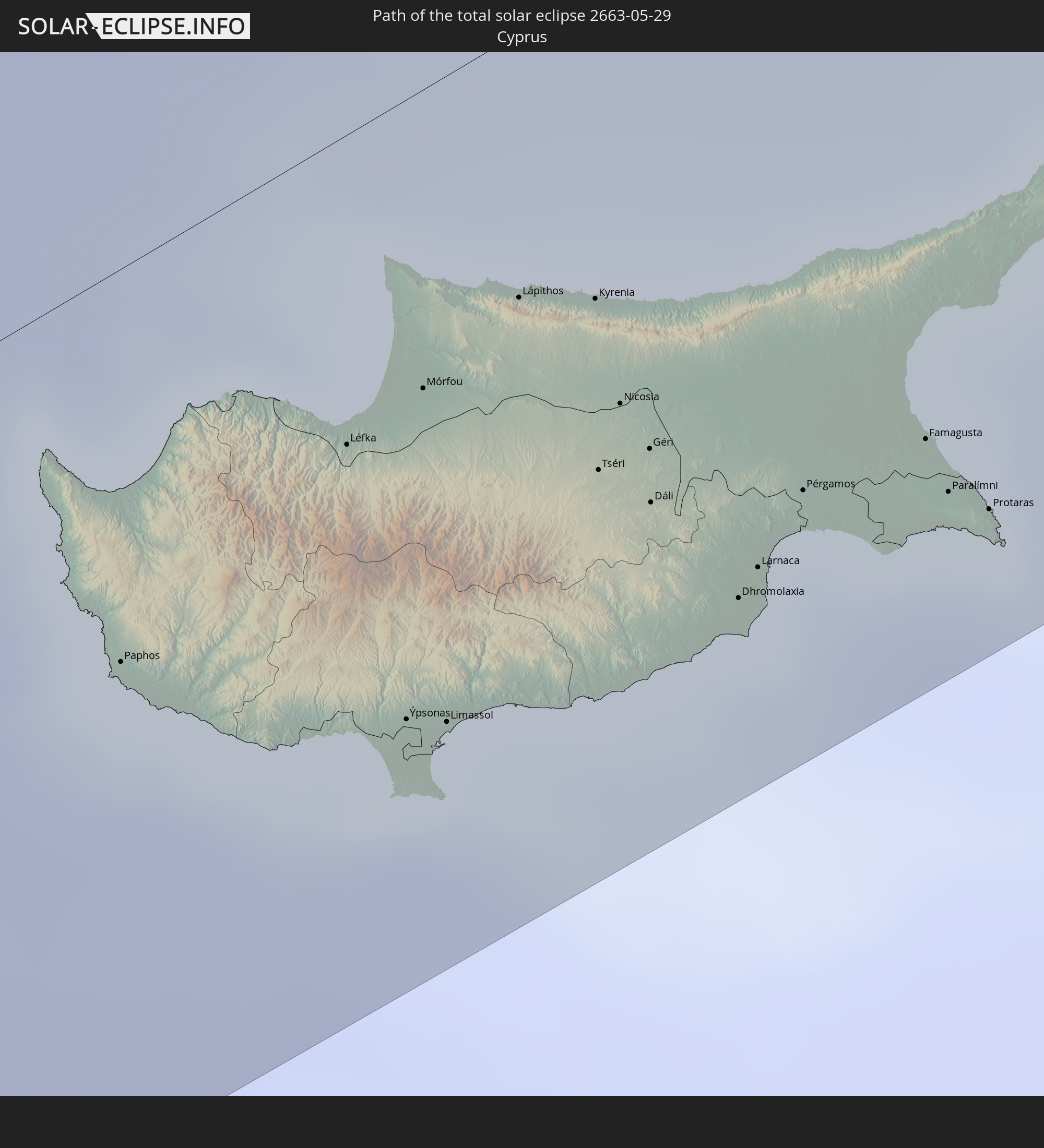
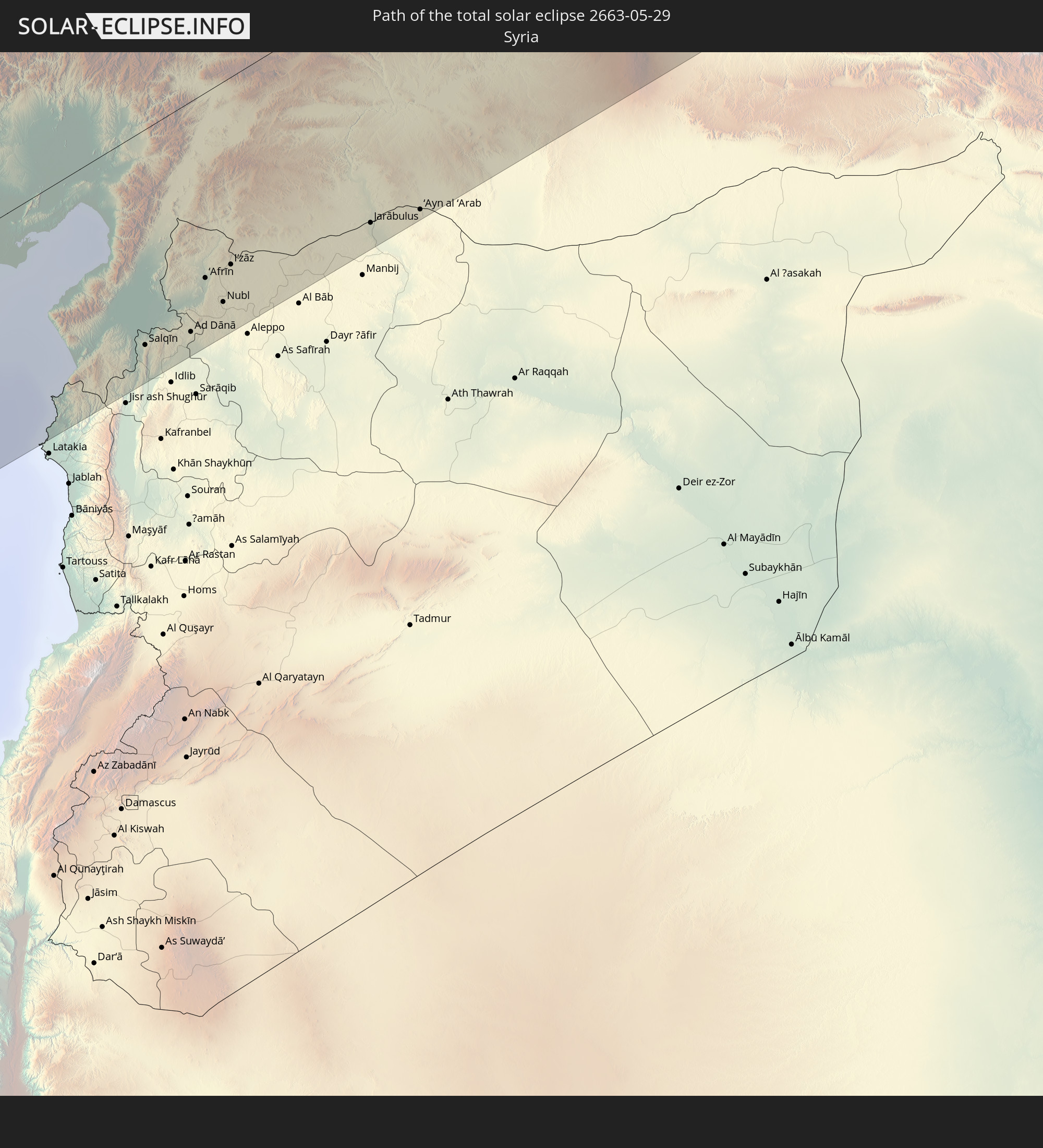
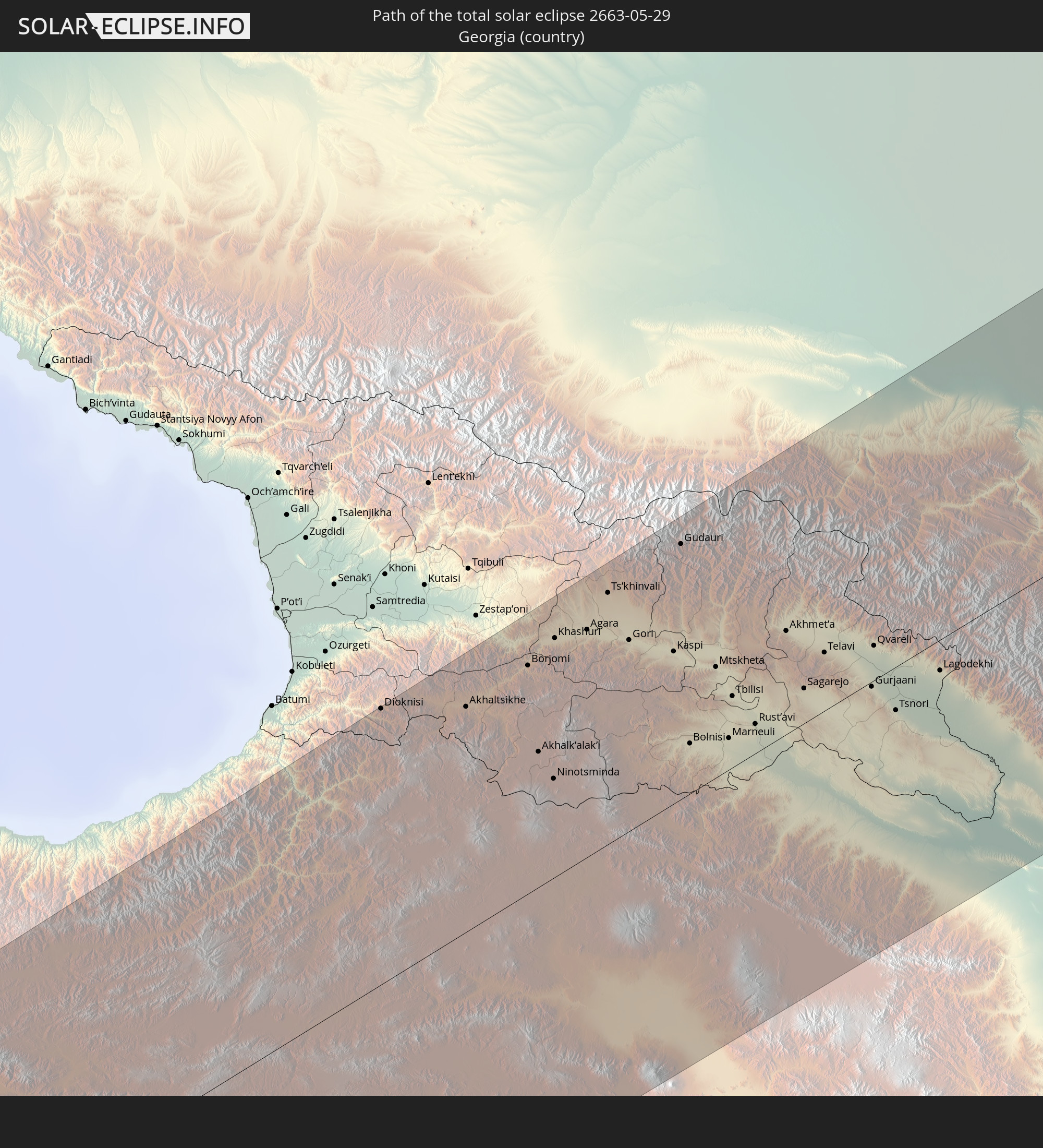
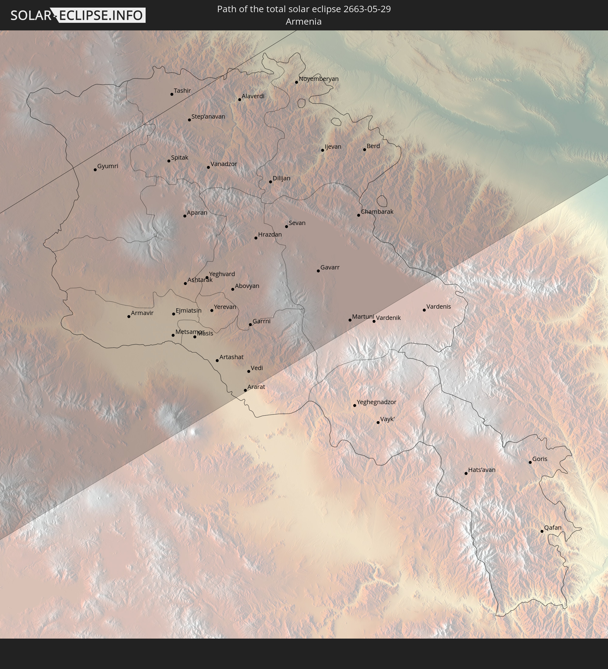
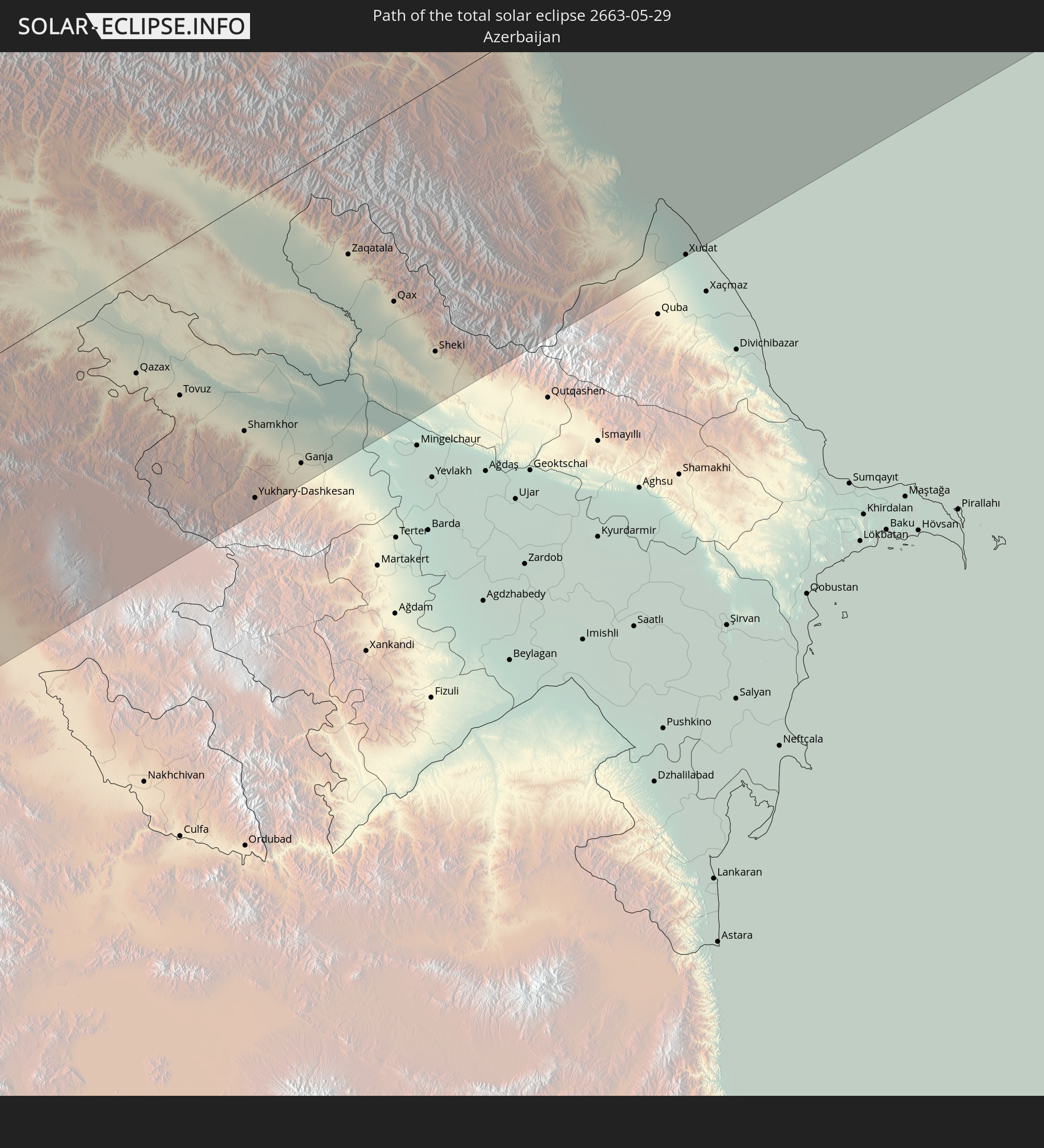
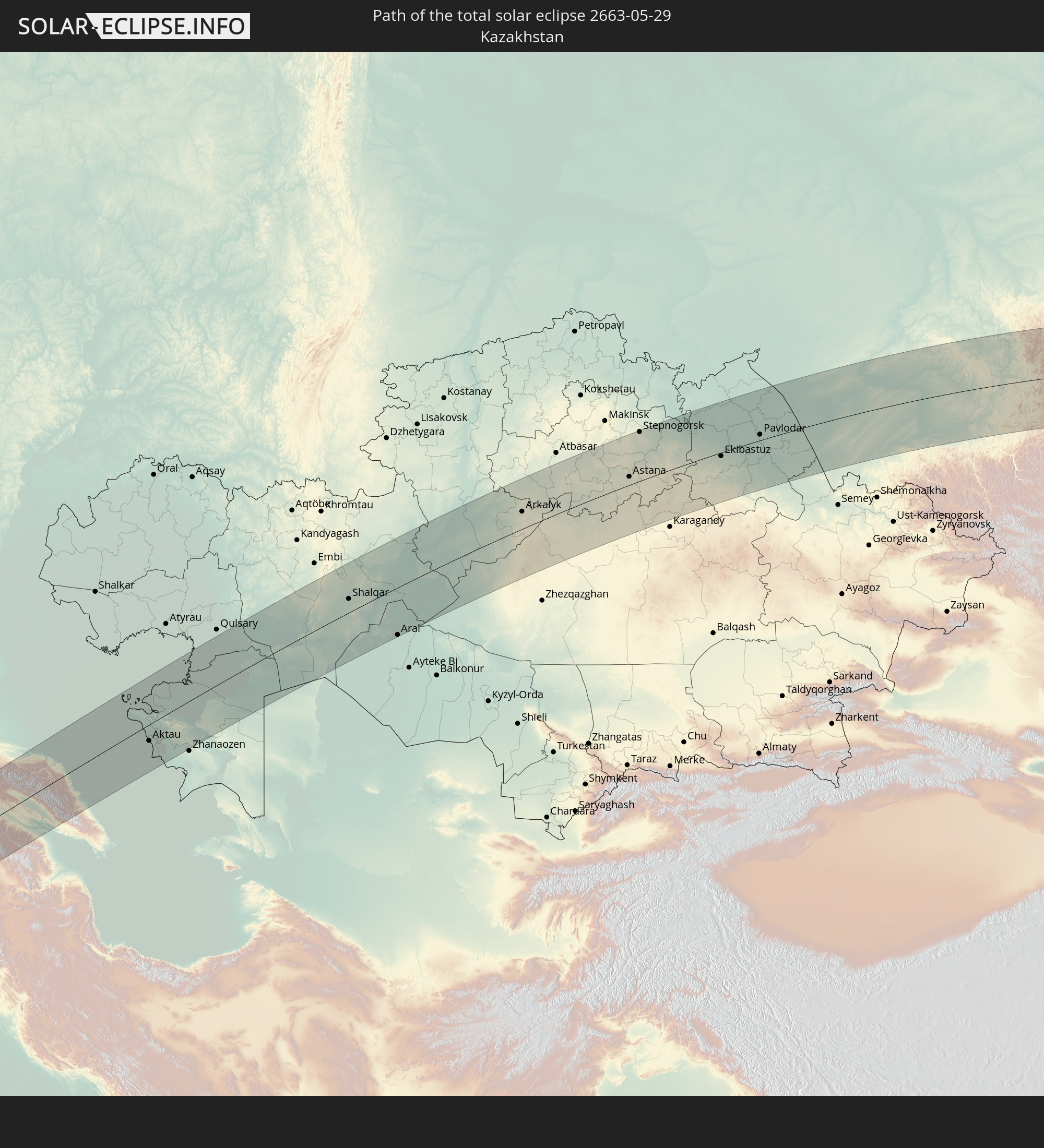
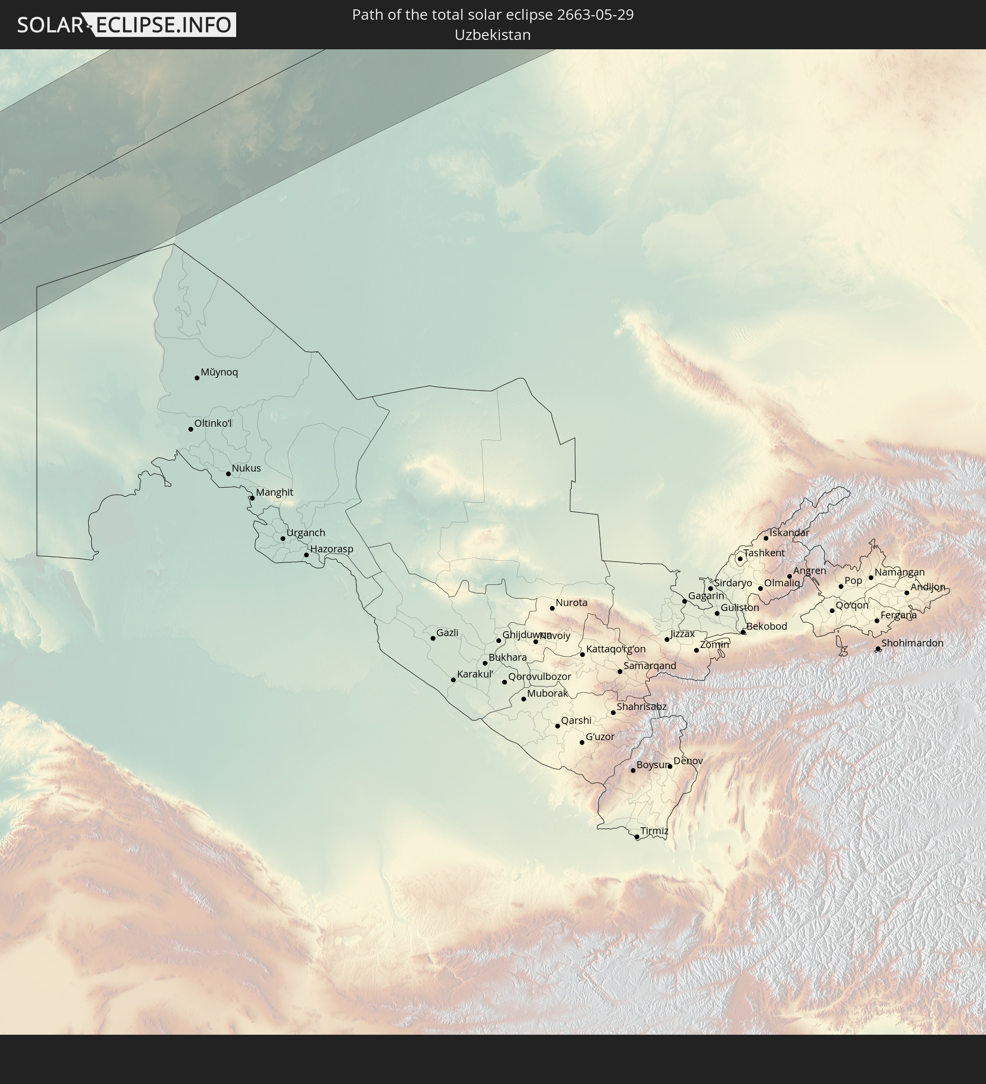
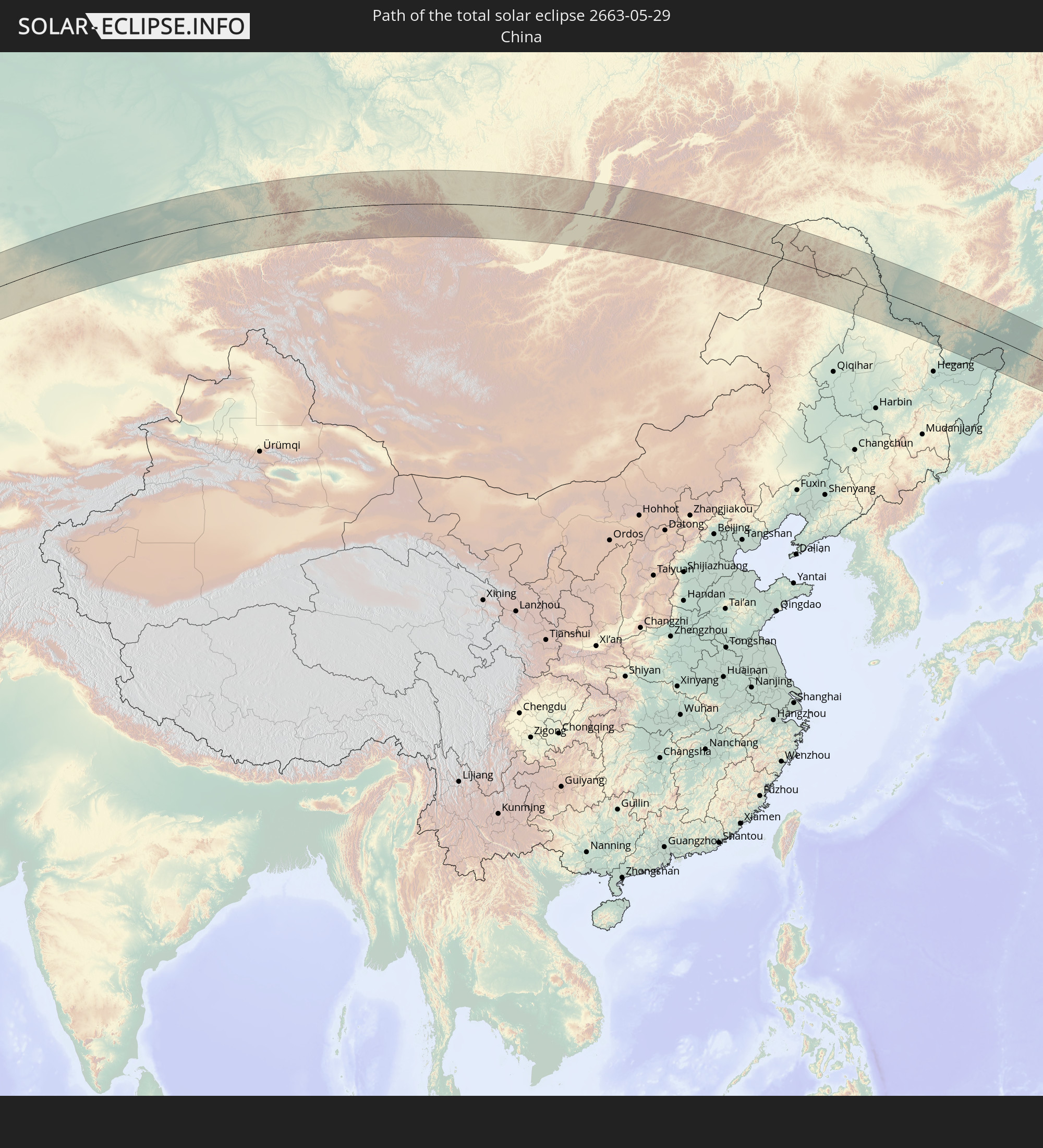
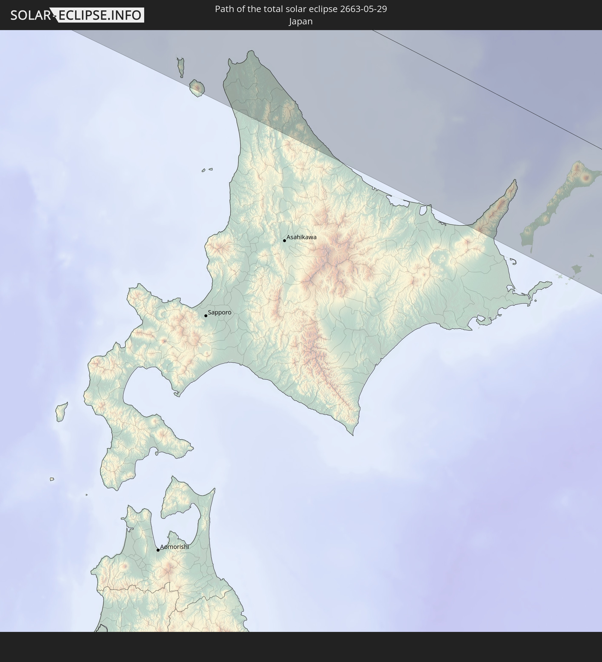
Detaillierte Länderkarten
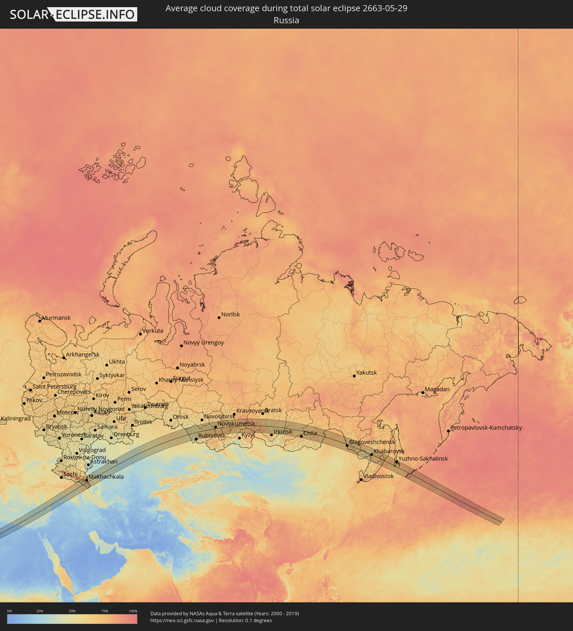 Russland
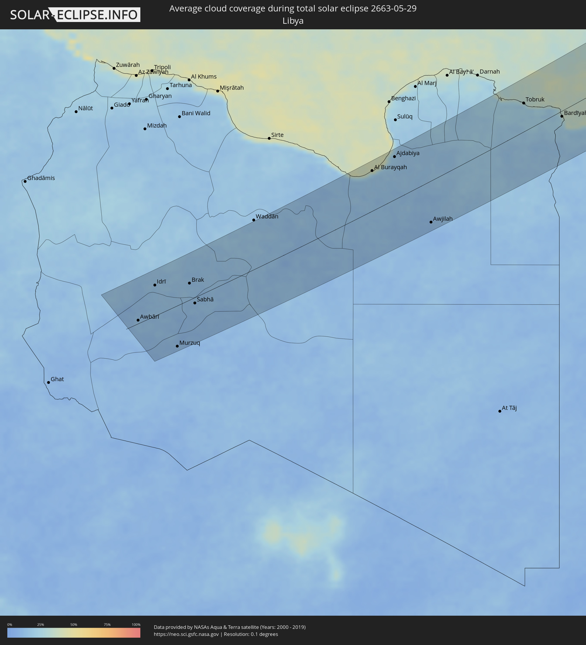 Libyen
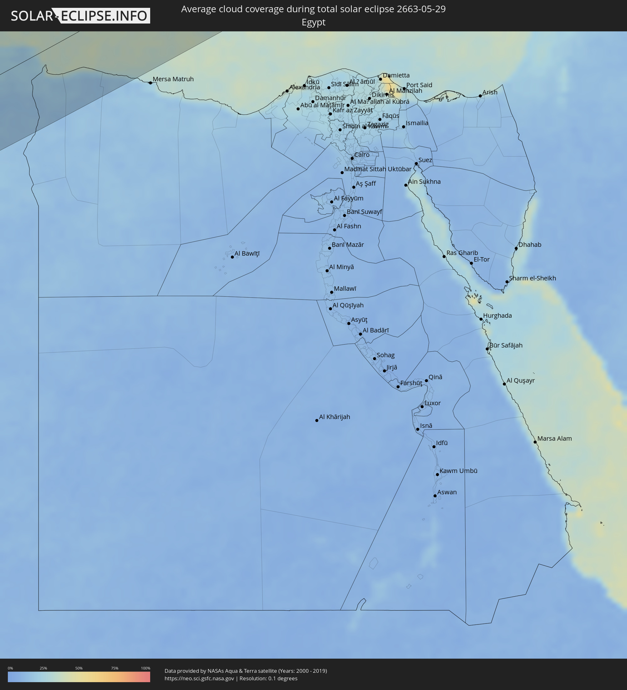 Ägypten
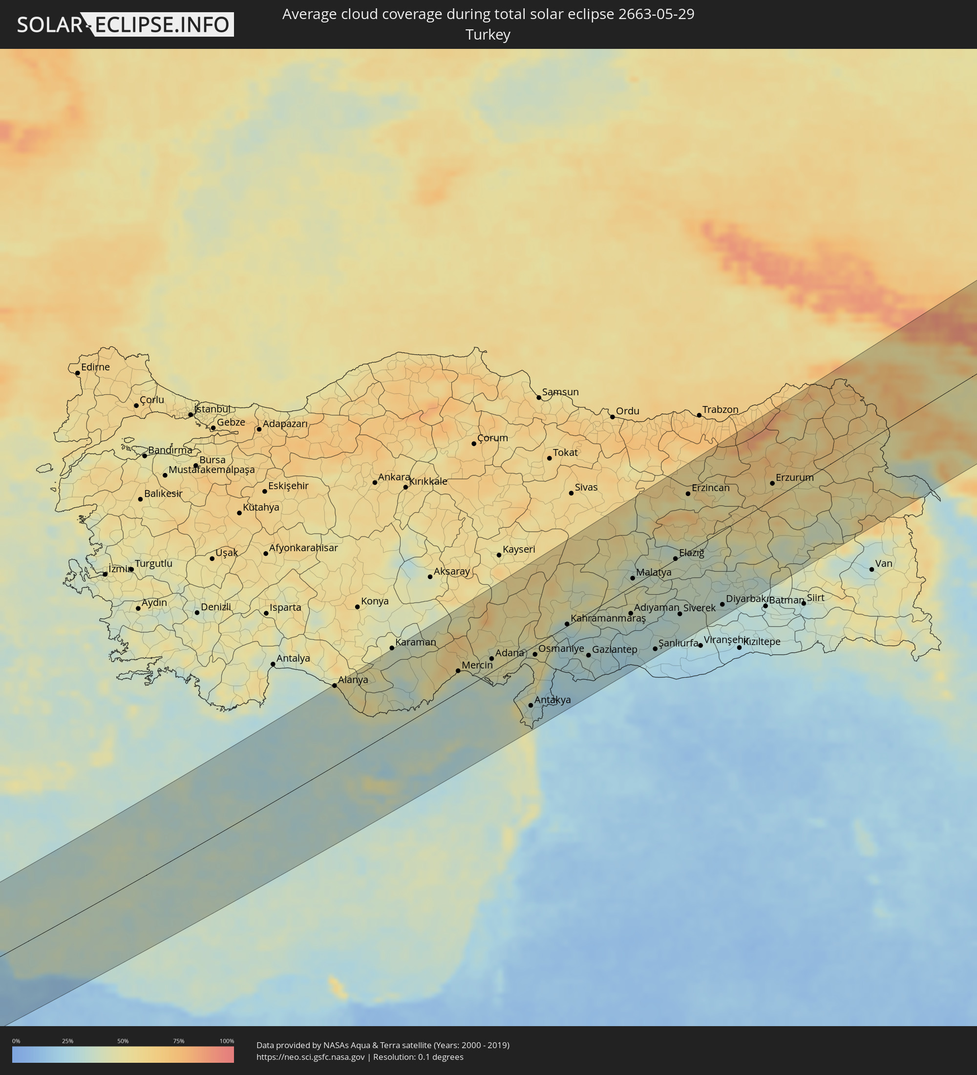 Türkei
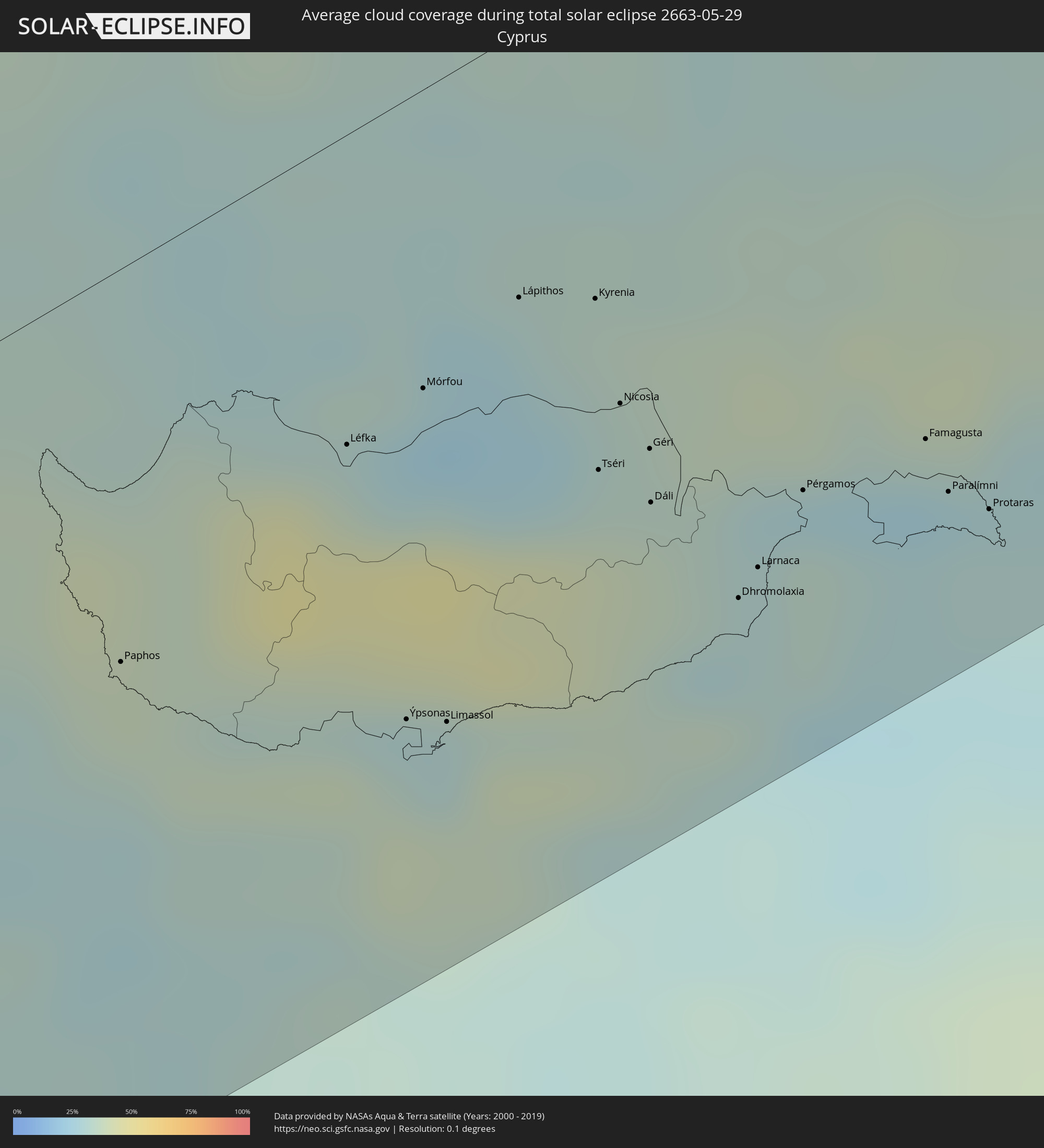 Republik Zypern
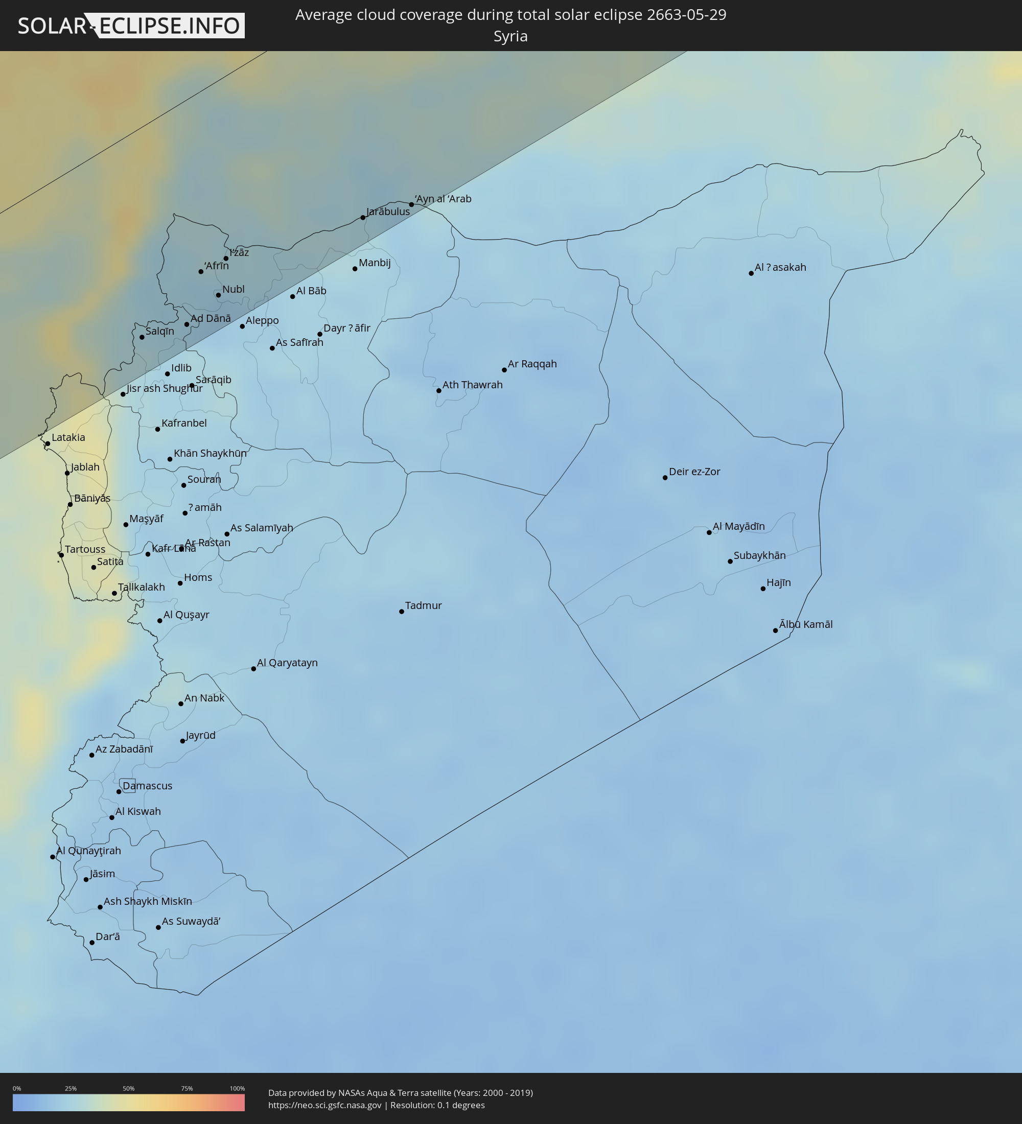 Syrien
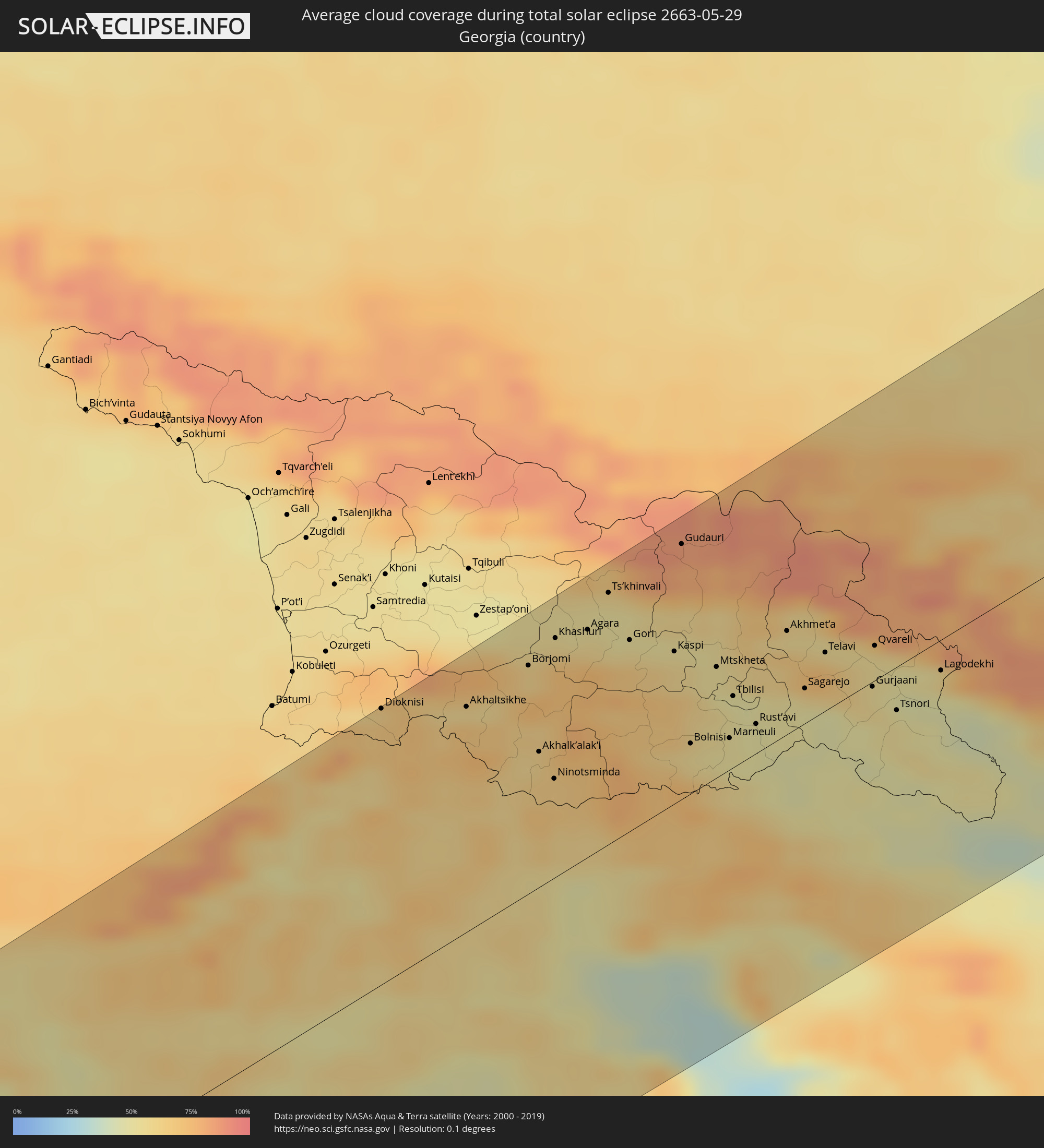 Georgien
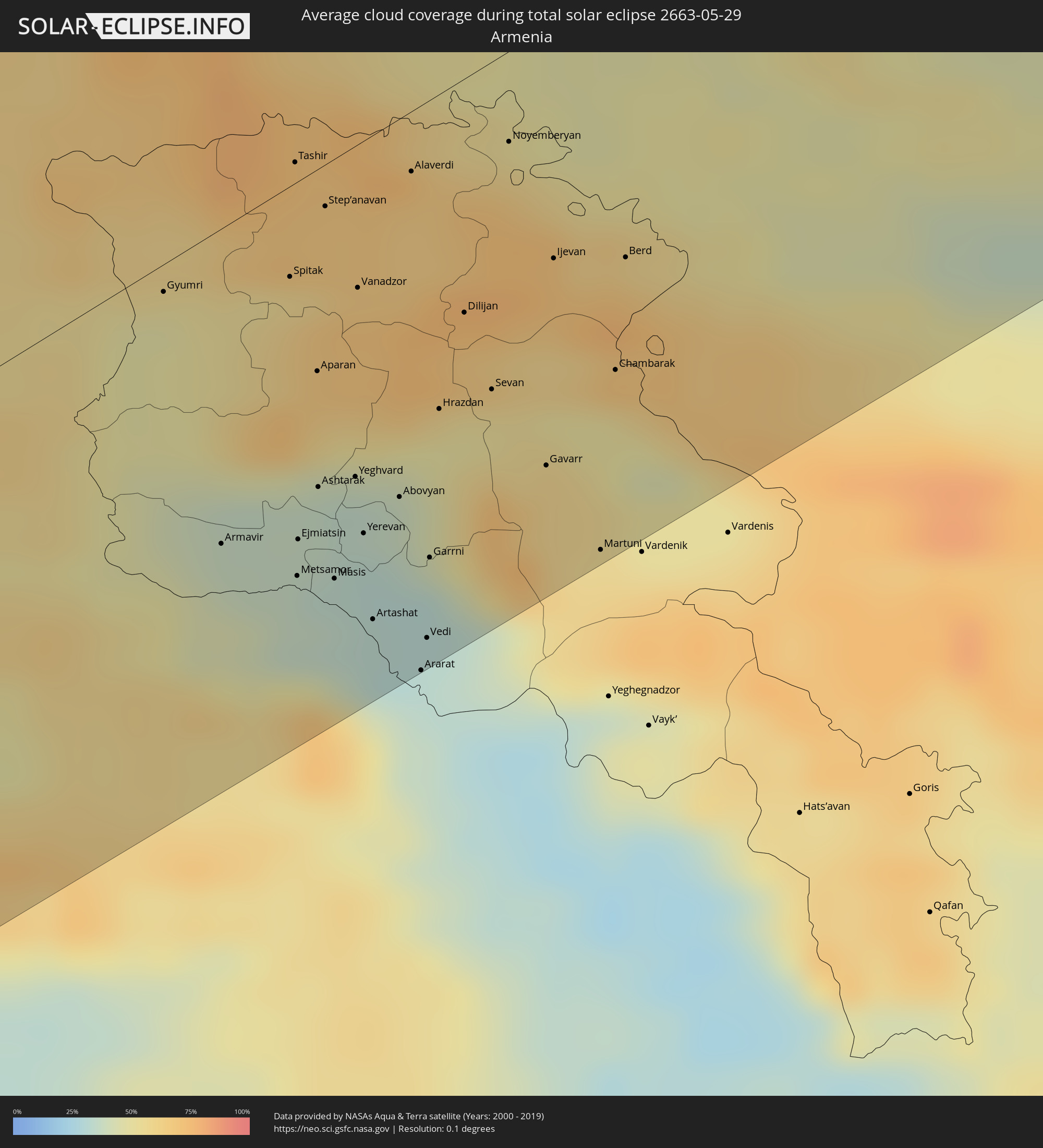 Armenien
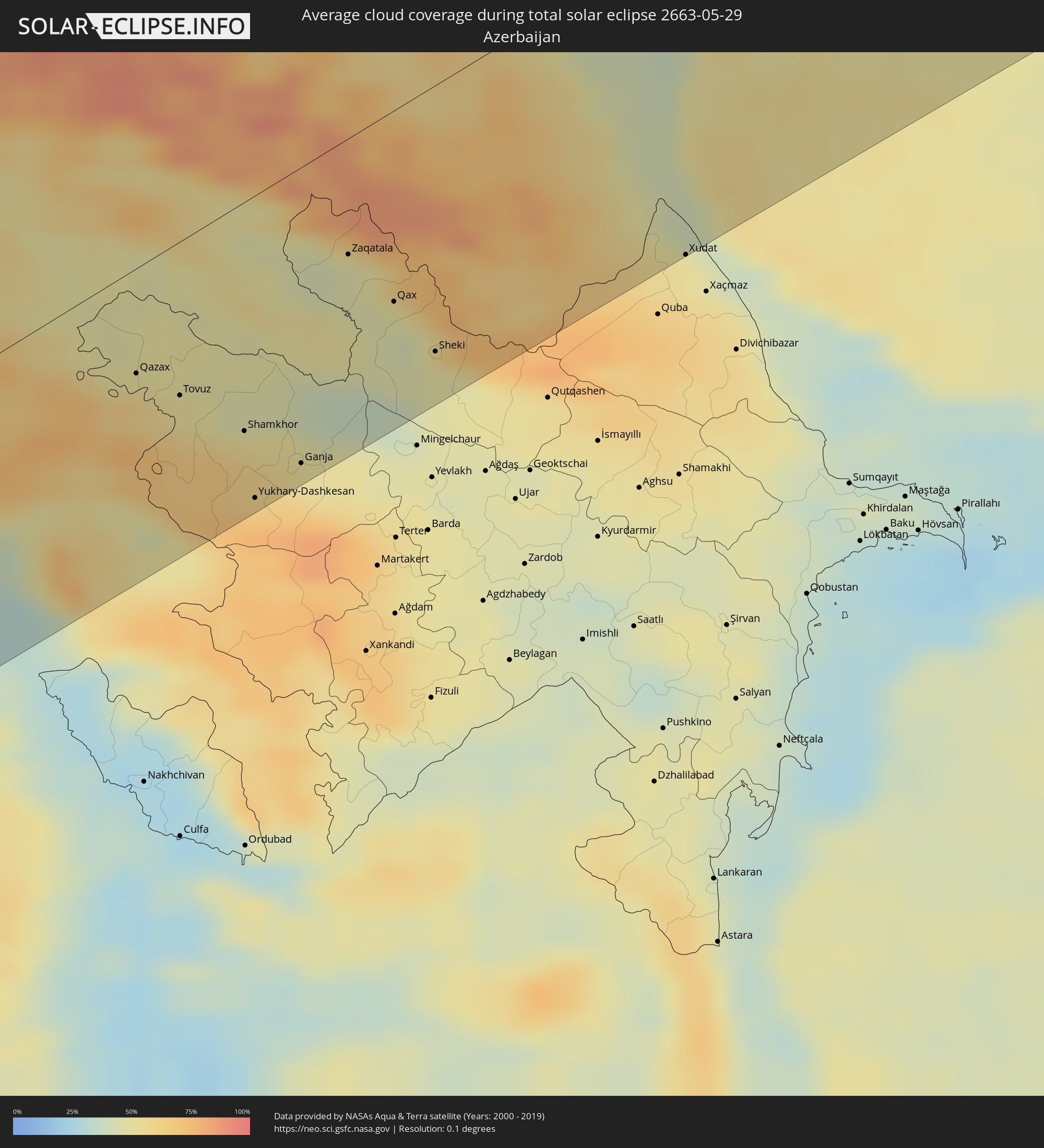 Aserbaidschan
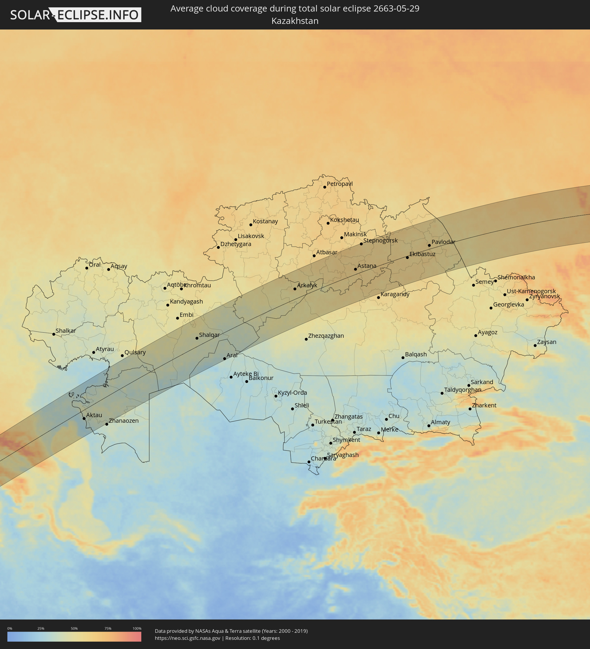 Kasachstan
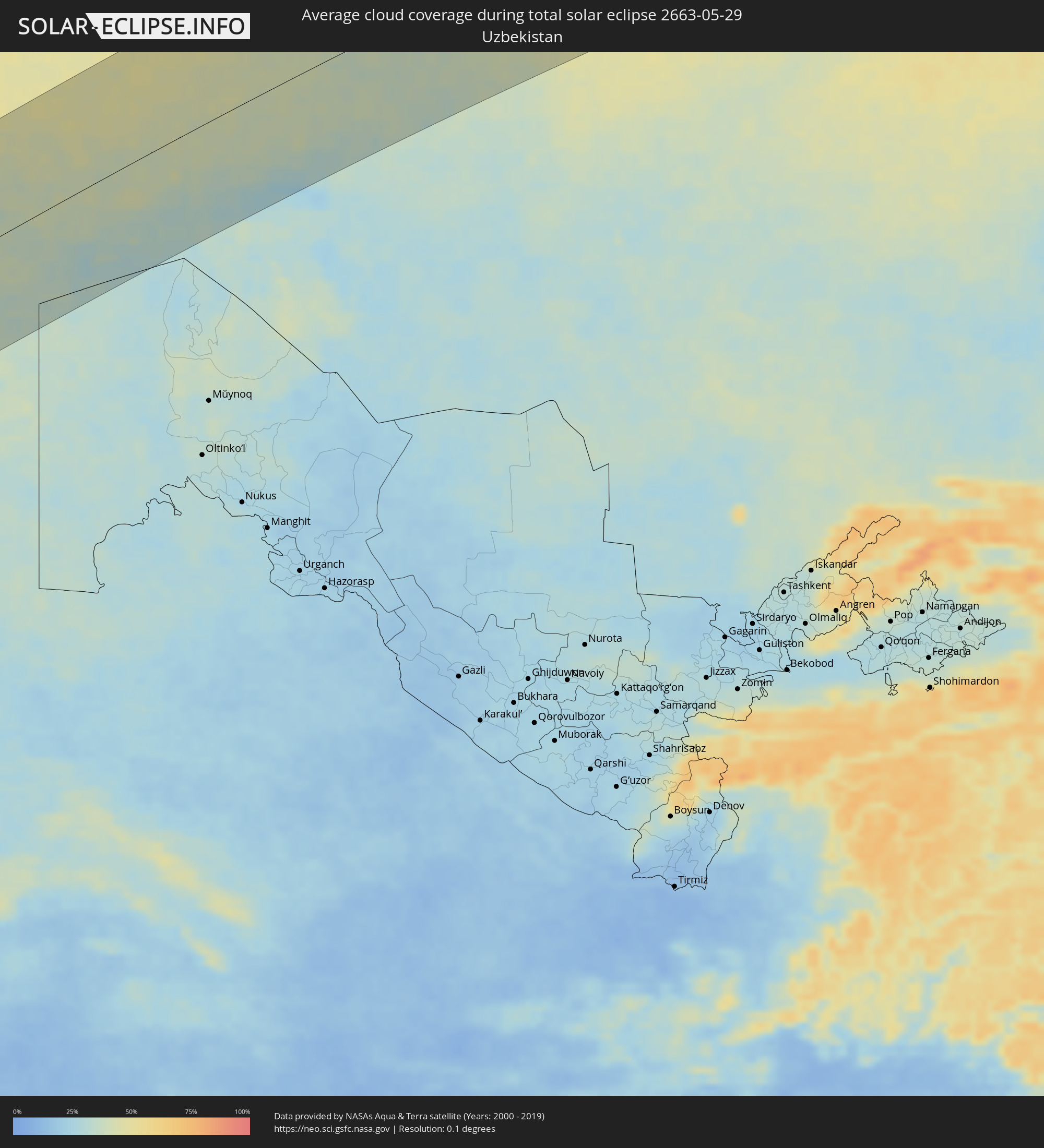 Usbekistan
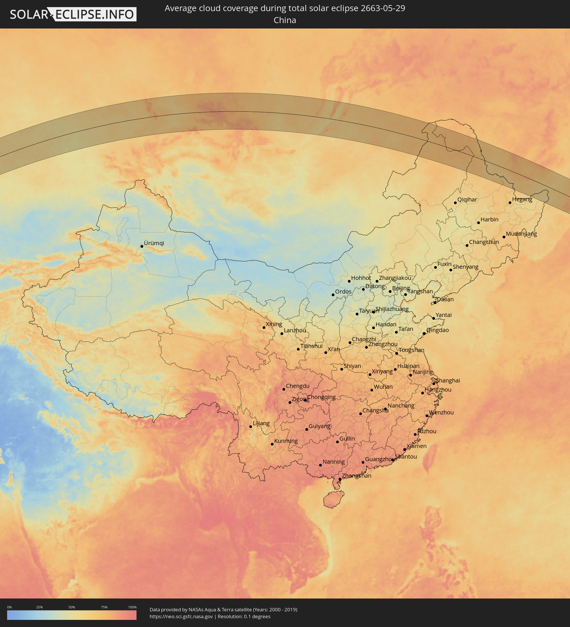 Volksrepublik China
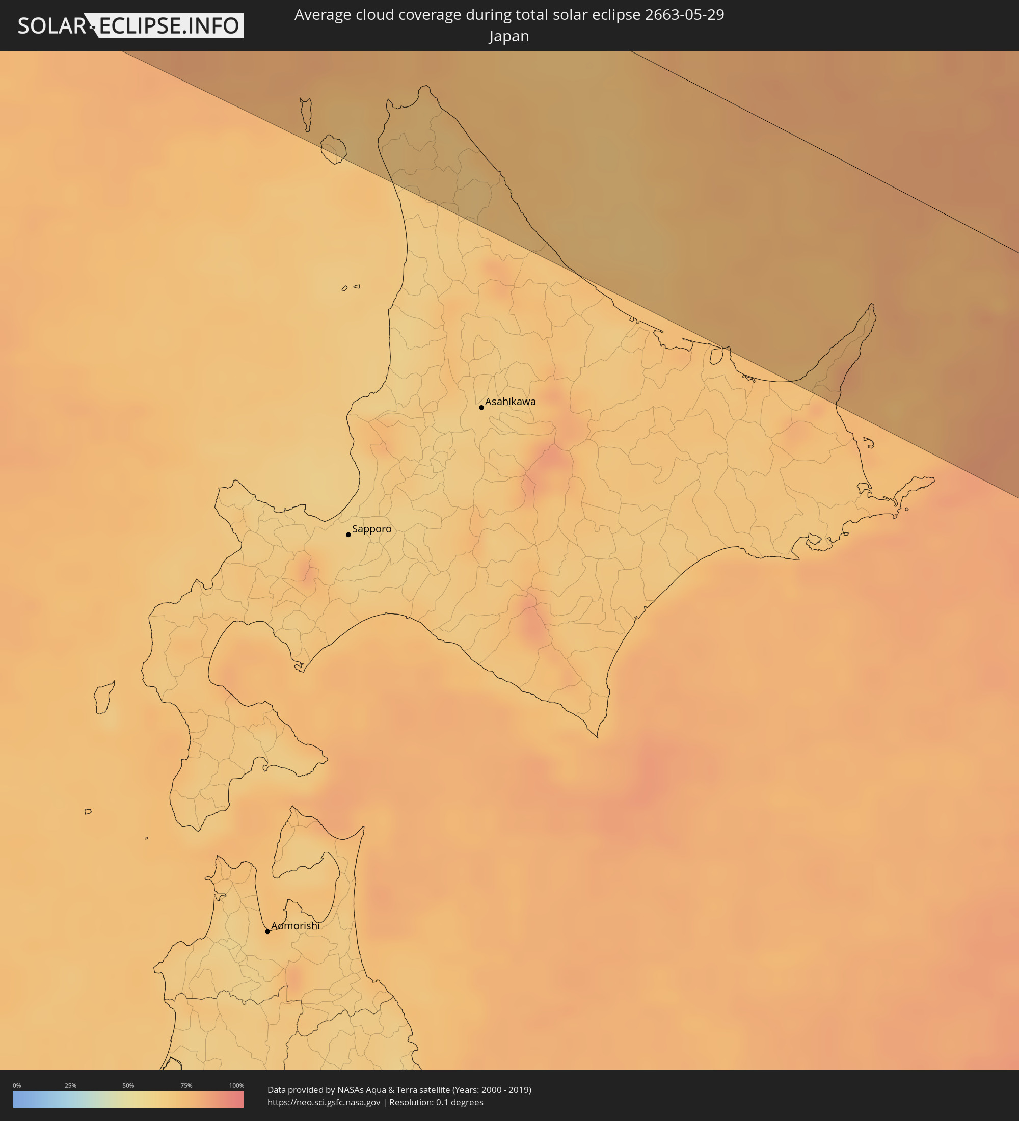 Japan
Japan
Orte im Finsternispfad
Die nachfolgene Tabelle zeigt Städte und Orte mit mehr als 5.000 Einwohnern, die sich im Finsternispfad befinden. Städte mit mehr als 100.000 Einwohnern sind dick gekennzeichnet. Mit einem Klick auf den Ort öffnet sich eine Detailkarte die die Lage des jeweiligen Ortes zusammen mit dem Verlauf der zentralen Finsternis präsentiert.
| Ort | Typ | Dauer der Verfinsterung | Ortszeit bei maximaler Verfinsterung | Entfernung zur Zentrallinie | Ø Bewölkung |
|
Awbārī, Sha‘bīyat Wādī al Ḩayāt
|
total | - | 06:23:47 UTC+02:00 | 22 km | 14% |
|
Idrī, Ash Shāţiʼ
|
total | - | 06:24:29 UTC+02:00 | 81 km | 14% |
|
Murzuq, Murzuq
|
total | - | 06:22:44 UTC+02:00 | 107 km | 11% |
|
Brak, Ash Shāţiʼ
|
total | - | 06:24:11 UTC+02:00 | 43 km | 14% |
|
Al Jadīd, Sabhā
|
total | - | 06:23:39 UTC+02:00 | 21 km | 13% |
|
Sabhā, Sabhā
|
total | - | 06:23:38 UTC+02:00 | 21 km | 14% |
|
Al Burayqah, Sha‘bīyat al Wāḩāt
|
total | - | 06:25:47 UTC+02:00 | 100 km | 19% |
|
Ajdabiya, Sha‘bīyat al Wāḩāt
|
total | - | 06:26:03 UTC+02:00 | 109 km | 17% |
|
Awjilah, Sha‘bīyat al Wāḩāt
|
total | - | 06:24:01 UTC+02:00 | 106 km | 11% |
|
Tobruk, Sha‘bīyat al Buţnān
|
total | - | 06:27:06 UTC+02:00 | 69 km | 25% |
|
Bardīyah, Sha‘bīyat al Buţnān
|
total | - | 06:26:38 UTC+02:00 | 14 km | 30% |
|
Alanya, Antalya
|
total | - | 07:33:10 UTC+03:00 | 133 km | 35% |
|
Paphos, Pafos
|
total | - | 06:30:50 UTC+02:00 | 59 km | 37% |
|
Léfka, Nicosia
|
total | - | 06:31:22 UTC+02:00 | 47 km | 37% |
|
Ýpsonas, Limassol
|
total | - | 06:30:49 UTC+02:00 | 92 km | 31% |
|
Mórfou, Nicosia
|
total | - | 06:31:30 UTC+02:00 | 51 km | 24% |
|
Limassol, Limassol
|
total | - | 06:30:49 UTC+02:00 | 95 km | 31% |
|
Lápithos, Keryneia
|
total | - | 06:31:44 UTC+02:00 | 39 km | 29% |
|
Kyrenia, Keryneia
|
total | - | 06:31:45 UTC+02:00 | 46 km | 33% |
|
Tséri, Nicosia
|
total | - | 06:31:24 UTC+02:00 | 72 km | 33% |
|
Nicosia, Nicosia
|
total | - | 06:31:33 UTC+02:00 | 63 km | 34% |
|
Géri, Nicosia
|
total | - | 06:31:28 UTC+02:00 | 73 km | 34% |
|
Dáli, Nicosia
|
total | - | 06:31:21 UTC+02:00 | 81 km | 36% |
|
Dhromolaxia, Larnaka
|
total | - | 06:31:11 UTC+02:00 | 102 km | 30% |
|
Aradíppou, Larnaka
|
total | - | 06:31:17 UTC+02:00 | 95 km | 30% |
|
Larnaca, Larnaka
|
total | - | 06:31:15 UTC+02:00 | 100 km | 30% |
|
Livádia, Larnaka
|
total | - | 06:31:17 UTC+02:00 | 97 km | 30% |
|
Pérgamos, Larnaka
|
total | - | 06:31:26 UTC+02:00 | 94 km | 33% |
|
Famagusta, Ammochostos
|
total | - | 06:31:35 UTC+02:00 | 96 km | 26% |
|
Paralímni, Ammochostos
|
total | - | 06:31:29 UTC+02:00 | 105 km | 30% |
|
Ereğli, Konya
|
total | - | 07:34:56 UTC+03:00 | 130 km | 43% |
|
Protaras, Ammochostos
|
total | - | 06:31:28 UTC+02:00 | 111 km | 30% |
|
Mercin, Mersin
|
total | - | 07:34:03 UTC+03:00 | 39 km | 40% |
|
Tarsus, Mersin
|
total | - | 07:34:17 UTC+03:00 | 34 km | 40% |
|
Adana, Adana
|
total | - | 07:34:31 UTC+03:00 | 21 km | 46% |
|
Ceyhan, Adana
|
total | - | 07:34:41 UTC+03:00 | 19 km | 44% |
|
Antakya, Hatay
|
total | - | 07:33:37 UTC+03:00 | 94 km | 32% |
|
İskenderun, Hatay
|
total | - | 07:34:10 UTC+03:00 | 61 km | 45% |
|
Osmaniye, Osmaniye
|
total | - | 07:34:52 UTC+03:00 | 22 km | 46% |
|
Salqīn, Idlib
|
total | - | 06:33:37 UTC+02:00 | 116 km | 26% |
|
Kafr Takhārīm, Idlib
|
total | - | 06:33:36 UTC+02:00 | 120 km | 26% |
|
Ad Dānā, Idlib
|
total | - | 06:33:48 UTC+02:00 | 122 km | 26% |
|
‘Afrīn, Aleppo
|
total | - | 06:34:16 UTC+02:00 | 99 km | 23% |
|
Kahramanmaraş, Kahramanmaraş
|
total | - | 07:35:49 UTC+03:00 | 7 km | 31% |
|
Nubl, Aleppo
|
total | - | 06:34:07 UTC+02:00 | 117 km | 19% |
|
I‘zāz, Aleppo
|
total | - | 06:34:25 UTC+02:00 | 98 km | 24% |
|
Tall Rif‘at, Aleppo
|
total | - | 06:34:16 UTC+02:00 | 112 km | 22% |
|
Gaziantep, Gaziantep
|
total | - | 07:35:12 UTC+03:00 | 69 km | 32% |
|
Jarābulus, Aleppo
|
total | - | 06:35:04 UTC+02:00 | 121 km | 26% |
|
Adıyaman, Adıyaman
|
total | - | 07:36:31 UTC+03:00 | 43 km | 38% |
|
Malatya, Malatya
|
total | - | 07:37:23 UTC+03:00 | 11 km | 42% |
|
‘Ayn al ‘Arab, Aleppo
|
total | - | 06:35:17 UTC+02:00 | 129 km | 24% |
|
Şanlıurfa, Şanlıurfa
|
total | - | 07:35:50 UTC+03:00 | 123 km | 29% |
|
Elazığ, Elazığ
|
total | - | 07:38:12 UTC+03:00 | 1 km | 41% |
|
Siverek, Şanlıurfa
|
total | - | 07:36:53 UTC+03:00 | 91 km | 34% |
|
Erzincan, Erzincan
|
total | - | 07:39:53 UTC+03:00 | 89 km | 50% |
|
Diyarbakır, Diyarbakır
|
total | - | 07:37:29 UTC+03:00 | 117 km | 31% |
|
Erzurum, Erzurum
|
total | - | 07:40:54 UTC+03:00 | 25 km | 64% |
|
Akhaltsikhe, Samtskhe-Javakheti
|
total | - | 08:44:22 UTC+04:00 | 113 km | 68% |
|
Borjomi, Samtskhe-Javakheti
|
total | - | 08:44:55 UTC+04:00 | 113 km | 61% |
|
Akhalk’alak’i
|
total | - | 08:44:16 UTC+04:00 | 68 km | 63% |
|
Surami
|
total | - | 08:45:15 UTC+04:00 | 124 km | 63% |
|
Khashuri, Shida Kartli
|
total | - | 08:45:14 UTC+04:00 | 119 km | 63% |
|
Gyumri, Shirak Province
|
total | - | 08:43:32 UTC+04:00 | 20 km | 48% |
|
Ts’khinvali, Shida Kartli
|
total | - | 08:45:47 UTC+04:00 | 126 km | 51% |
|
Armavir, Armavir Province
|
total | - | 08:42:40 UTC+04:00 | 76 km | 38% |
|
Gori, Shida Kartli
|
total | - | 08:45:30 UTC+04:00 | 96 km | 58% |
|
Spitak, Lori Province
|
total | - | 08:43:49 UTC+04:00 | 25 km | 66% |
|
Ejmiatsin, Armavir Province
|
total | - | 08:42:49 UTC+04:00 | 89 km | 36% |
|
Ashtarak, Aragatsotn Province
|
total | - | 08:43:03 UTC+04:00 | 77 km | 35% |
|
Step’anavan, Lori Province
|
total | - | 08:44:09 UTC+04:00 | 20 km | 67% |
|
Masis, Ararat Province
|
total | - | 08:42:44 UTC+04:00 | 103 km | 33% |
|
Kaspi, Shida Kartli
|
total | - | 08:45:35 UTC+04:00 | 75 km | 59% |
|
Gudauri
|
total | - | 08:46:28 UTC+04:00 | 127 km | 84% |
|
Vanadzor, Lori Province
|
total | - | 08:43:54 UTC+04:00 | 41 km | 70% |
|
Yerevan, Yerevan
|
total | - | 08:42:58 UTC+04:00 | 95 km | 33% |
|
Bolnisi, Kvemo Kartli
|
total | - | 08:44:55 UTC+04:00 | 31 km | 59% |
|
Artashat, Ararat Province
|
total | - | 08:42:39 UTC+04:00 | 118 km | 32% |
|
Alaverdi, Lori Province
|
total | - | 08:44:27 UTC+04:00 | 17 km | 65% |
|
Ararat, Ararat Province
|
total | - | 08:42:32 UTC+04:00 | 137 km | 33% |
|
Vedi, Ararat Province
|
total | - | 08:42:41 UTC+04:00 | 129 km | 32% |
|
Hrazdan, Kotayk Province
|
total | - | 08:43:35 UTC+04:00 | 78 km | 50% |
|
Marneuli, Kvemo Kartli
|
total | - | 08:45:06 UTC+04:00 | 18 km | 51% |
|
Tbilisi, T'bilisi
|
total | - | 08:45:27 UTC+04:00 | 36 km | 51% |
|
Dilijan, Tavush Province
|
total | - | 08:44:00 UTC+04:00 | 56 km | 64% |
|
Sevan, Gegharkunik Province
|
total | - | 08:43:46 UTC+04:00 | 79 km | 52% |
|
Rust’avi, Kvemo Kartli
|
total | - | 08:45:20 UTC+04:00 | 17 km | 48% |
|
Gardabani, Kvemo Kartli
|
total | - | 08:45:15 UTC+04:00 | 10 km | 47% |
|
Gavarr, Gegharkunik Province
|
total | - | 08:43:35 UTC+04:00 | 105 km | 59% |
|
Ijevan, Tavush Province
|
total | - | 08:44:23 UTC+04:00 | 59 km | 71% |
|
Akhmet’a, Kakheti
|
total | - | 08:46:12 UTC+04:00 | 51 km | 65% |
|
Martuni, Gegharkunik Province
|
total | - | 08:43:21 UTC+04:00 | 133 km | 60% |
|
Sagarejo, Kakheti
|
total | - | 08:45:49 UTC+04:00 | 18 km | 49% |
|
Qazax, Qazax
|
total | - | 08:44:51 UTC+04:00 | 46 km | 52% |
|
Aghstafa, Ağstafa
|
total | - | 08:44:56 UTC+04:00 | 49 km | 51% |
|
Telavi, Kakheti
|
total | - | 08:46:11 UTC+04:00 | 32 km | 68% |
|
Tovuz, Tovuz
|
total | - | 08:44:51 UTC+04:00 | 69 km | 53% |
|
Gurjaani, Kakheti
|
total | - | 08:46:06 UTC+04:00 | 2 km | 55% |
|
Kyadabek, Gǝdǝbǝy
|
total | - | 08:44:19 UTC+04:00 | 115 km | 67% |
|
Qvareli, Kakheti
|
total | - | 08:46:27 UTC+04:00 | 17 km | 56% |
|
Dzagam, Şǝmkir
|
total | - | 08:44:52 UTC+04:00 | 87 km | 53% |
|
Shamkhor, Şǝmkir
|
total | - | 08:44:50 UTC+04:00 | 99 km | 57% |
|
Yukhary-Dashkesan, Daşkǝsǝn
|
total | - | 08:44:24 UTC+04:00 | 133 km | 70% |
|
Qarayeri, Samux
|
total | - | 08:44:57 UTC+04:00 | 116 km | 51% |
|
Yelenendorf, Goygol Rayon
|
total | - | 08:44:39 UTC+04:00 | 135 km | 62% |
|
Ganja, Gǝncǝ
|
total | - | 08:44:49 UTC+04:00 | 128 km | 52% |
|
Belokany, Balakǝn
|
total | - | 08:46:27 UTC+04:00 | 30 km | 45% |
|
Samux, Samux
|
total | - | 08:44:59 UTC+04:00 | 123 km | 49% |
|
Khasavyurt, Dagestan
|
total | - | 07:48:56 UTC+03:00 | 109 km | 57% |
|
Aliabad, Zaqatala
|
total | - | 08:46:13 UTC+04:00 | 63 km | 45% |
|
Zaqatala, Zaqatala
|
total | - | 08:46:28 UTC+04:00 | 52 km | 44% |
|
Çinarlı, Qǝx
|
total | - | 08:46:23 UTC+04:00 | 77 km | 52% |
|
Qax, Qǝx
|
total | - | 08:46:18 UTC+04:00 | 82 km | 46% |
|
Sheki, Shaki City
|
total | - | 08:46:07 UTC+04:00 | 114 km | 48% |
|
Makhachkala, Dagestan
|
total | - | 07:49:06 UTC+03:00 | 47 km | 52% |
|
Kaspiysk, Dagestan
|
total | - | 07:49:02 UTC+03:00 | 32 km | 54% |
|
Derbent, Dagestan
|
total | - | 07:48:13 UTC+03:00 | 81 km | 48% |
|
Xudat, Xaçmaz
|
total | - | 08:47:49 UTC+04:00 | 138 km | 51% |
|
Aktau, Mangghystaū
|
total | - | 09:52:48 UTC+05:00 | 49 km | 34% |
|
Yeraliyev, Mangghystaū
|
total | - | 09:52:29 UTC+05:00 | 113 km | 32% |
|
Zhetibay, Mangghystaū
|
total | - | 09:53:26 UTC+05:00 | 90 km | 38% |
|
Shetpe, Mangghystaū
|
total | - | 09:54:21 UTC+05:00 | 38 km | 40% |
|
Qaraton, Atyraū
|
total | - | 09:59:00 UTC+05:00 | 128 km | 39% |
|
Beyneu, Mangghystaū
|
total | - | 09:58:47 UTC+05:00 | 47 km | 34% |
|
Shalqar, Aqtöbe
|
total | - | 10:06:49 UTC+05:00 | 39 km | 42% |
|
Sekseūil, Qyzylorda
|
total | - | 10:07:22 UTC+05:00 | 88 km | 36% |
|
Aral, Qyzylorda
|
total | - | 10:07:31 UTC+05:00 | 135 km | 32% |
|
Arkalyk, Qostanay
|
total | - | 10:18:16 UTC+05:00 | 48 km | 52% |
|
Astana, Astana Qalasy
|
total | - | 10:24:59 UTC+05:00 | 23 km | 61% |
|
Stepnogorsk, Aqmola
|
total | - | 10:26:49 UTC+05:00 | 134 km | 59% |
|
Temirtau, Qaraghandy
|
total | - | 10:25:45 UTC+05:00 | 133 km | 59% |
|
Aqtaū, Qaraghandy
|
total | - | 10:26:05 UTC+05:00 | 115 km | 59% |
|
Yereymentau, Aqmola
|
total | - | 10:27:37 UTC+05:00 | 34 km | 61% |
|
Ekibastuz, Pavlodar
|
total | - | 10:30:39 UTC+05:00 | 19 km | 58% |
|
Qashyr, Pavlodar
|
total | - | 10:32:57 UTC+05:00 | 117 km | 58% |
|
Aksu, Pavlodar
|
total | - | 10:33:07 UTC+05:00 | 12 km | 57% |
|
Pavlodar, Pavlodar
|
total | - | 10:33:23 UTC+05:00 | 16 km | 59% |
|
Barnaul, Altai Krai
|
total | - | 12:43:37 UTC+07:00 | 23 km | 61% |
|
Biysk, Altai Krai
|
total | - | 12:45:16 UTC+07:00 | 90 km | 61% |
|
Leninsk-Kuznetsky, Kemerovo
|
total | - | 12:47:36 UTC+07:00 | 131 km | 65% |
|
Belovo, Kemerovo
|
total | - | 12:47:40 UTC+07:00 | 104 km | 63% |
|
Prokop’yevsk, Kemerovo
|
total | - | 12:48:03 UTC+07:00 | 45 km | 63% |
|
Novokuznetsk, Kemerovo
|
total | - | 12:48:33 UTC+07:00 | 25 km | 64% |
|
Mezhdurechensk, Kemerovo
|
total | - | 12:49:53 UTC+07:00 | 8 km | 62% |
|
Abakan, Khakasiya
|
total | - | 12:54:44 UTC+07:00 | 19 km | 62% |
|
Minusinsk, Krasnoyarskiy
|
total | - | 12:55:07 UTC+07:00 | 23 km | 63% |
|
Usol’ye-Sibirskoye, Irkutsk
|
total | - | 14:12:36 UTC+08:00 | 133 km | 57% |
|
Chita, Transbaikal Territory
|
total | - | 15:26:25 UTC+09:00 | 118 km | 64% |
|
Genhe, Inner Mongolia
|
total | - | 14:37:13 UTC+08:00 | 112 km | 70% |
|
Oroqen Zizhiqi, Inner Mongolia
|
total | - | 14:39:49 UTC+08:00 | 88 km | 71% |
|
Jagdaqi, Inner Mongolia
|
total | - | 14:40:25 UTC+08:00 | 94 km | 70% |
|
Tahe, Heilongjiang
|
total | - | 14:38:38 UTC+08:00 | 122 km | 75% |
|
Heihe, Heilongjiang
|
total | - | 14:43:56 UTC+08:00 | 33 km | 65% |
|
Blagoveshchensk, Amur
|
total | - | 15:43:56 UTC+09:00 | 29 km | 65% |
|
Birobidzhan, Jewish Autonomous Oblast
|
total | - | 16:50:34 UTC+10:00 | 34 km | 65% |
|
Fuyuan, Heilongjiang
|
total | - | 14:52:13 UTC+08:00 | 36 km | 61% |
|
Khabarovsk, Khabarovsk Krai
|
total | - | 16:52:37 UTC+10:00 | 7 km | 62% |
|
Wakkanai, Hokkaido
|
total | - | 16:01:08 UTC+09:00 | 95 km | 68% |
|
Makubetsu, Hokkaido
|
total | - | 16:01:16 UTC+09:00 | 92 km | 68% |
|
Yuzhno-Sakhalinsk, Sakhalin
|
total | - | 17:59:28 UTC+11:00 | 98 km | 74% |