Totale Sonnenfinsternis vom 21.07.2726
| Wochentag: | Mittwoch |
| Maximale Dauer der Verfinsterung: | 05m43s |
| Maximale Breite des Finsternispfades: | 288 km |
| Saroszyklus: | 167 |
| Bedeckungsgrad: | 100% |
| Magnitude: | 1.078 |
| Gamma: | 0.4807 |
Wo kann man die Sonnenfinsternis vom 21.07.2726 sehen?
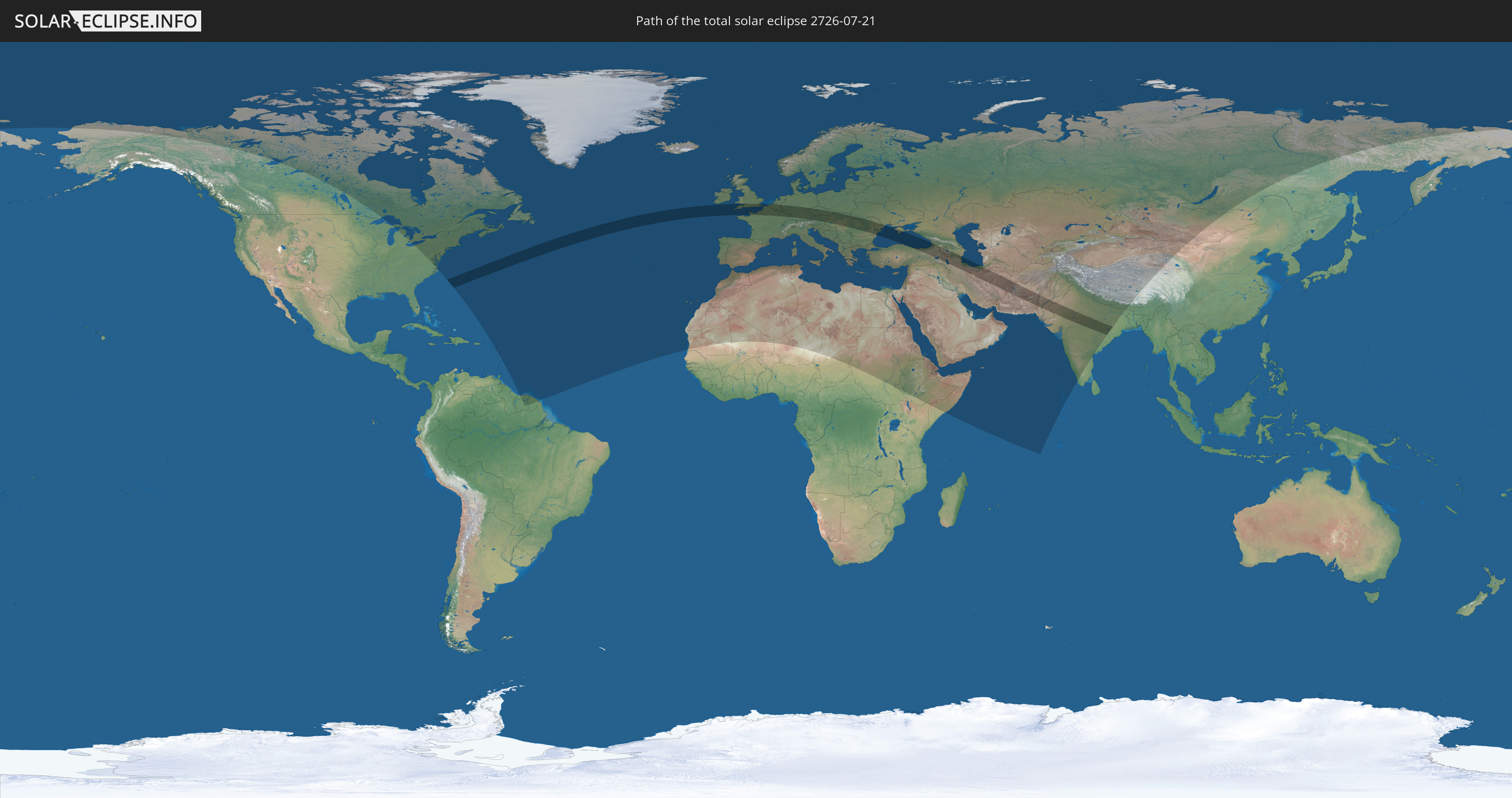
Die Sonnenfinsternis am 21.07.2726 kann man in 108 Ländern als partielle Sonnenfinsternis beobachten.
Der Finsternispfad verläuft durch 24 Länder. Nur in diesen Ländern ist sie als totale Sonnenfinsternis zu sehen.
In den folgenden Ländern ist die Sonnenfinsternis total zu sehen
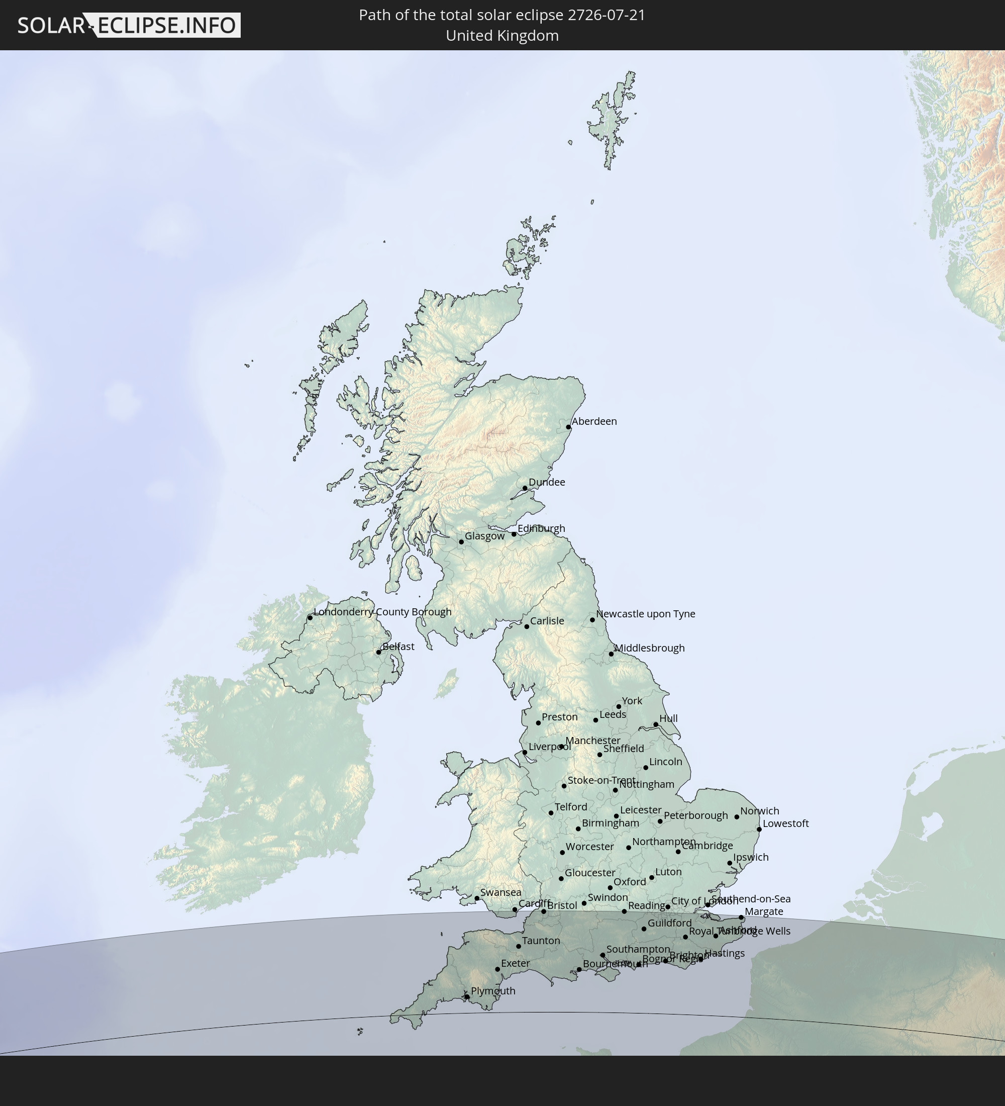 Vereinigtes Königreich
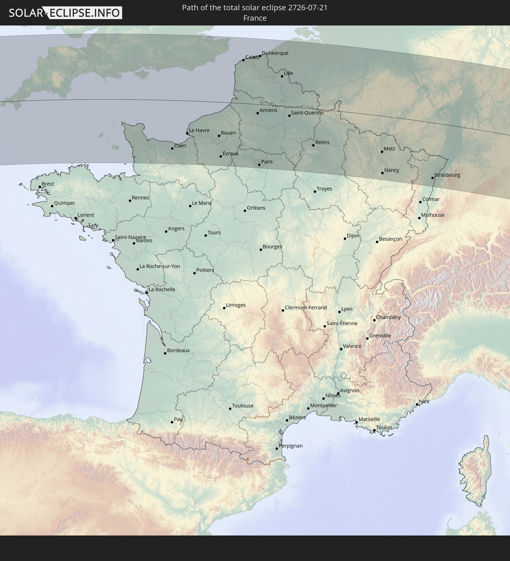 Frankreich
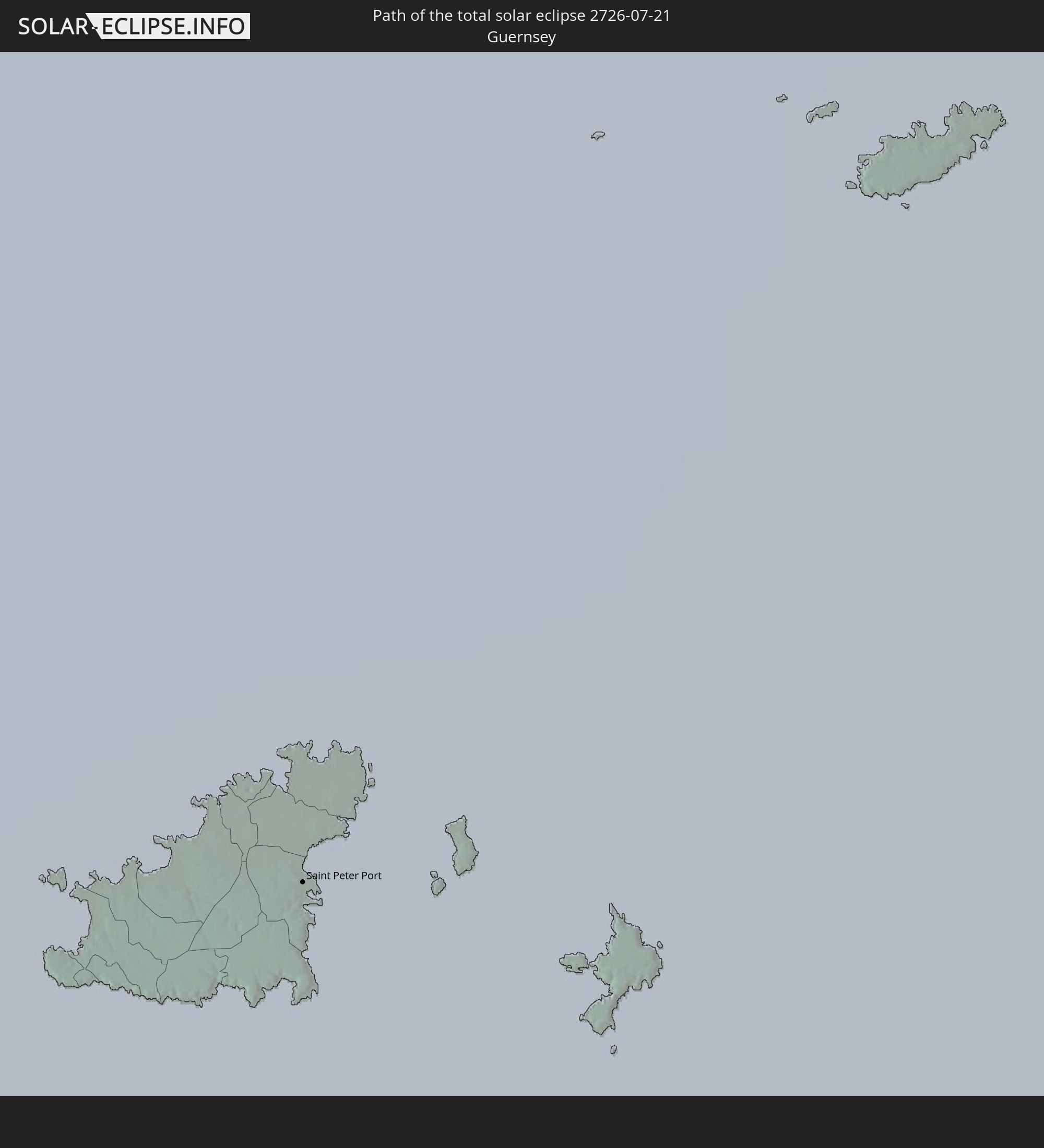 Guernsey
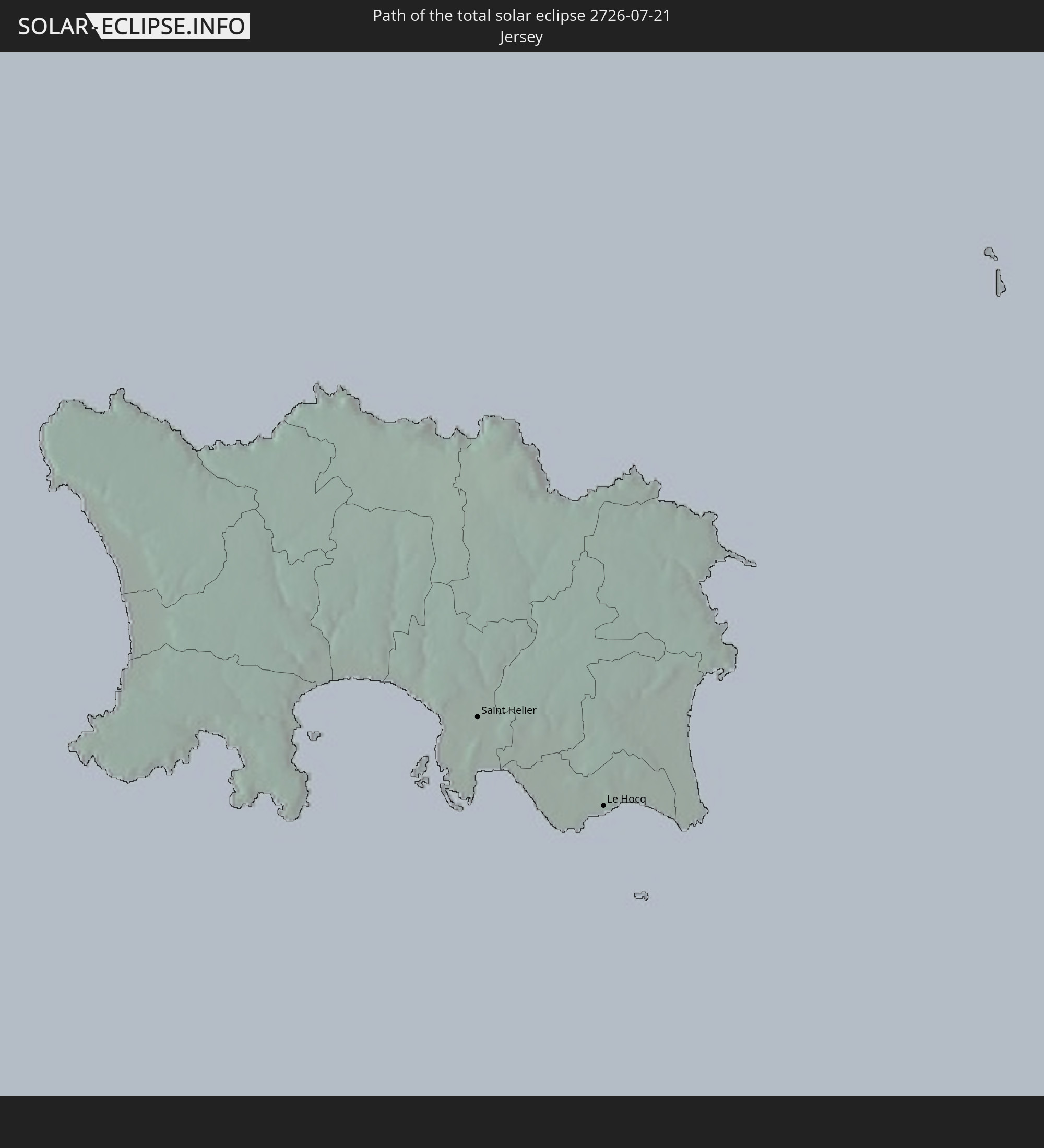 Jersey
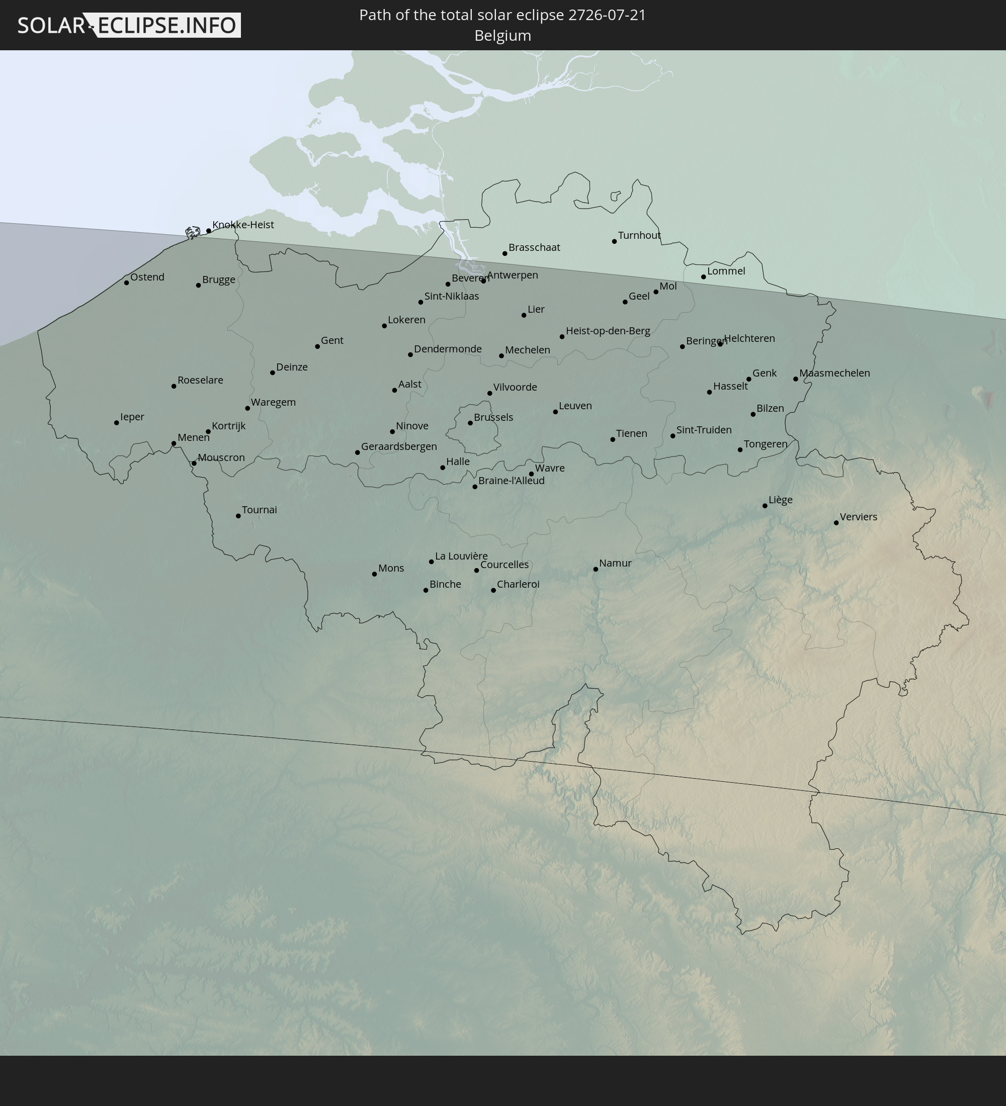 Belgien
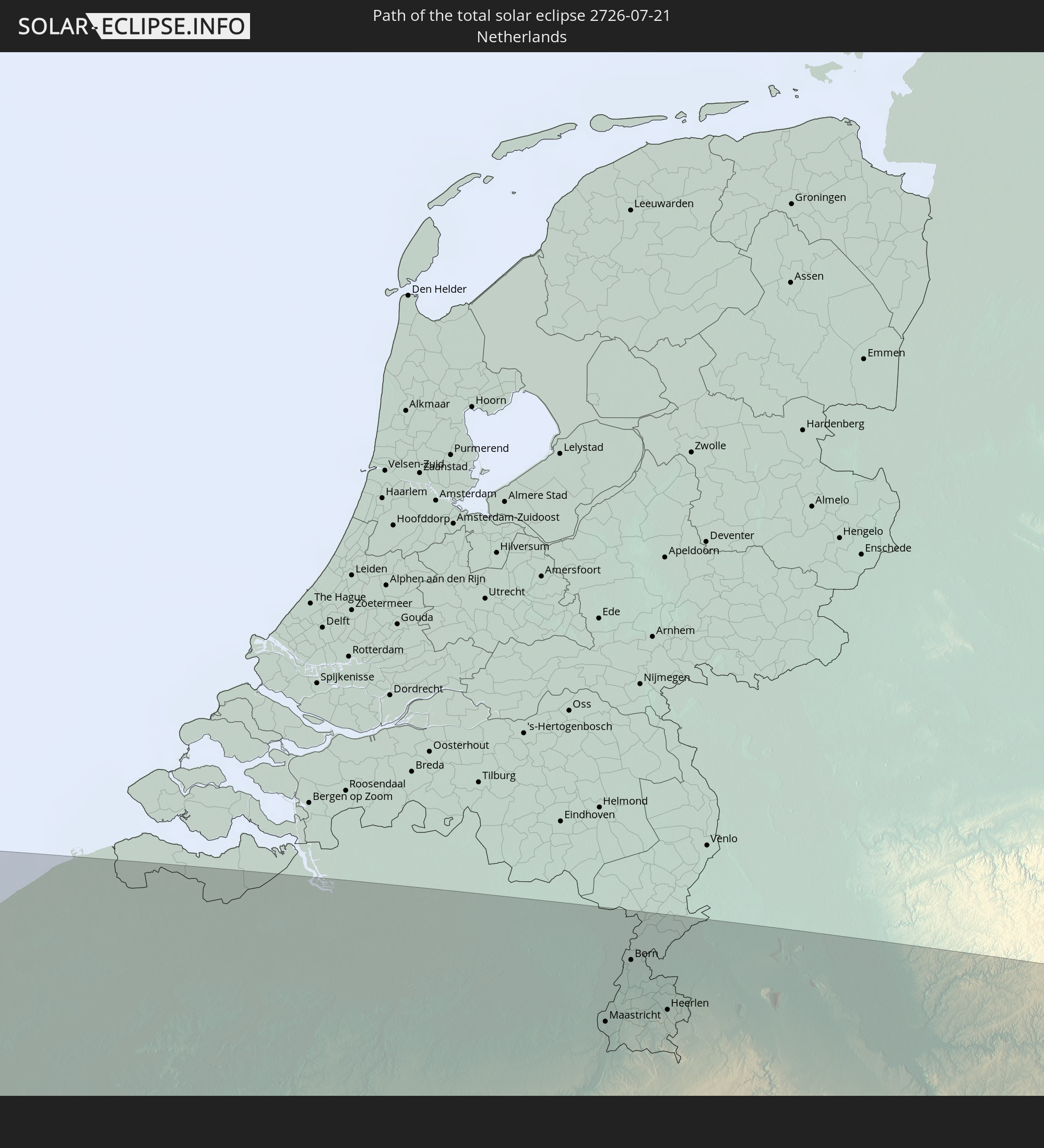 Niederlande
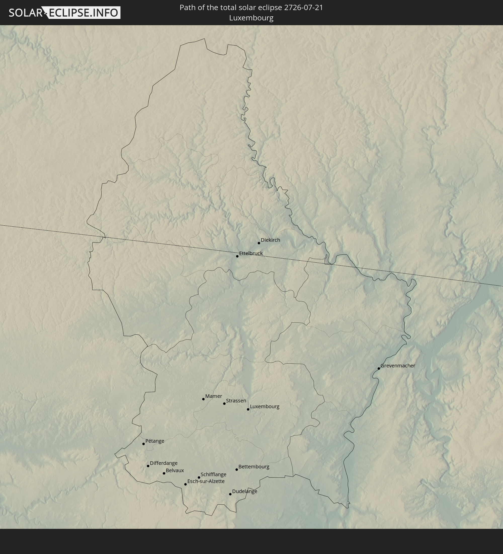 Luxemburg
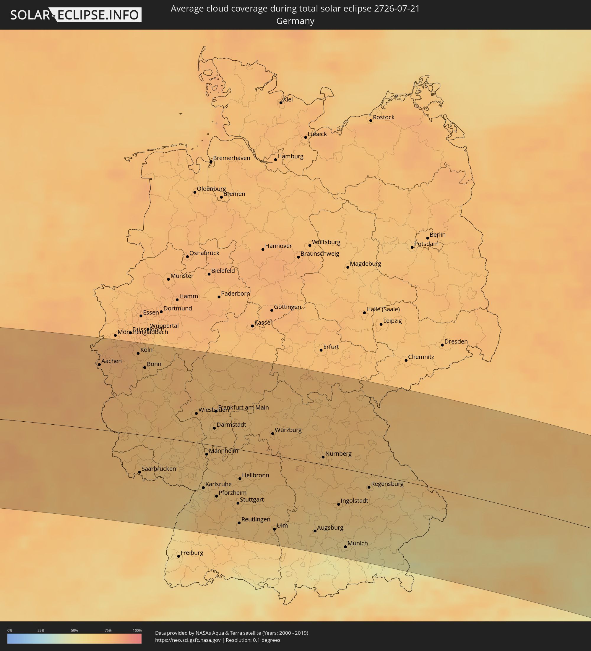
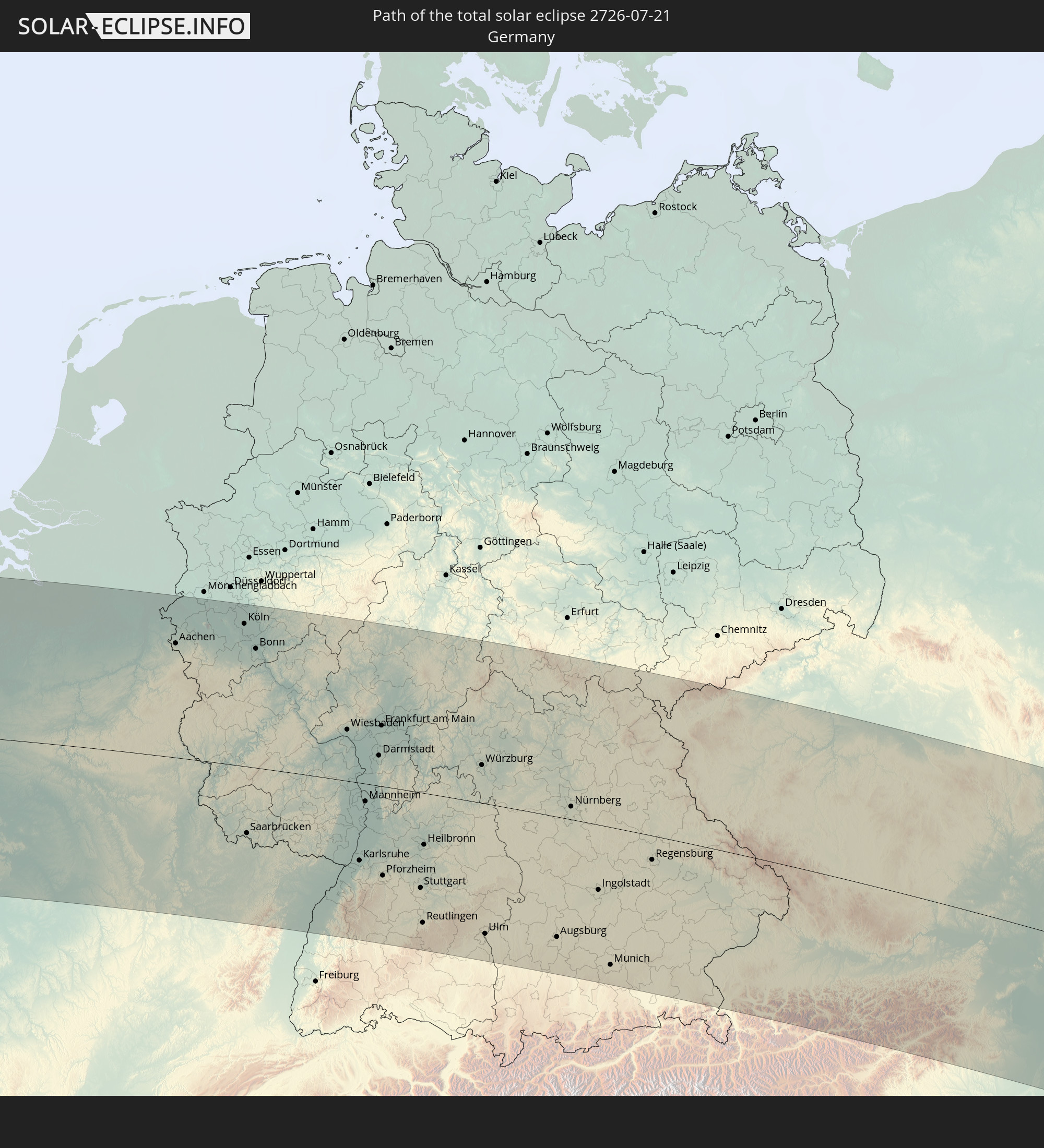 Deutschland
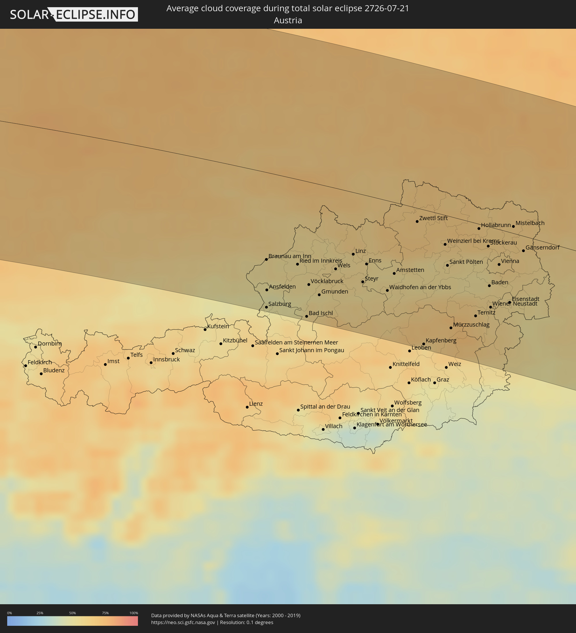
 Österreich
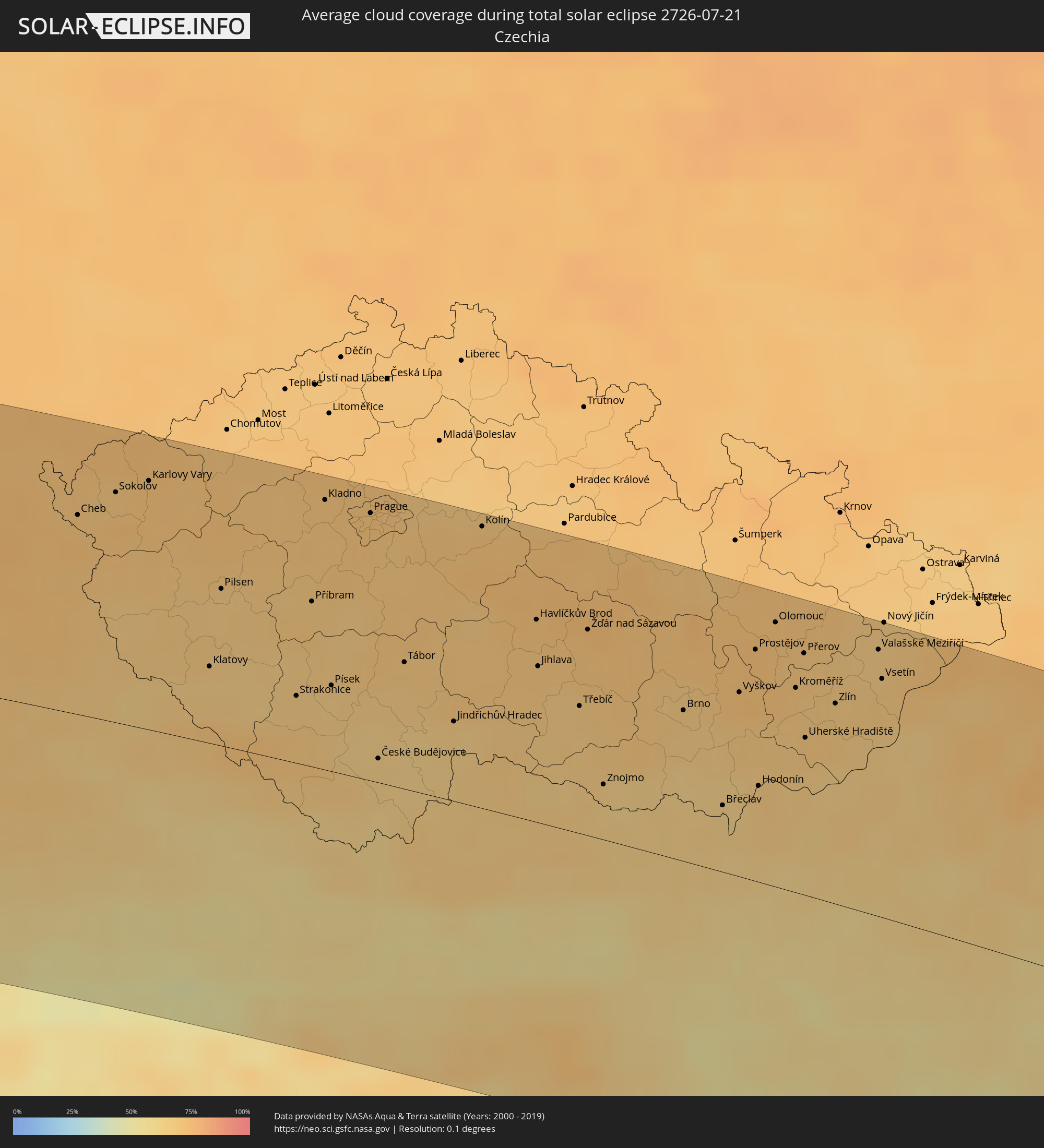
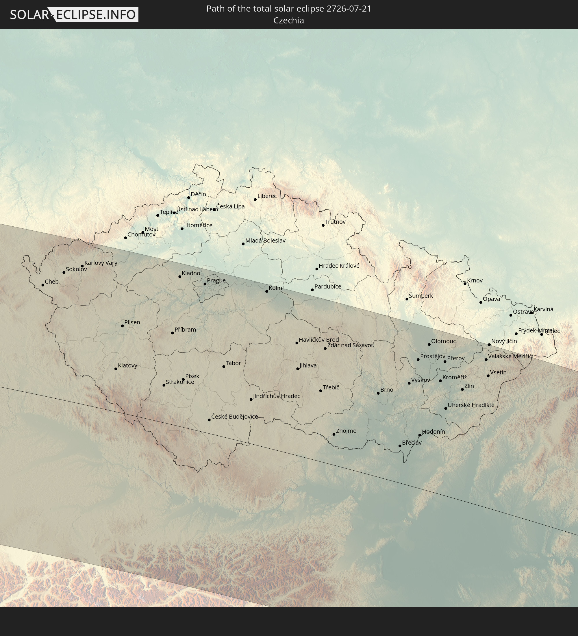 Tschechien
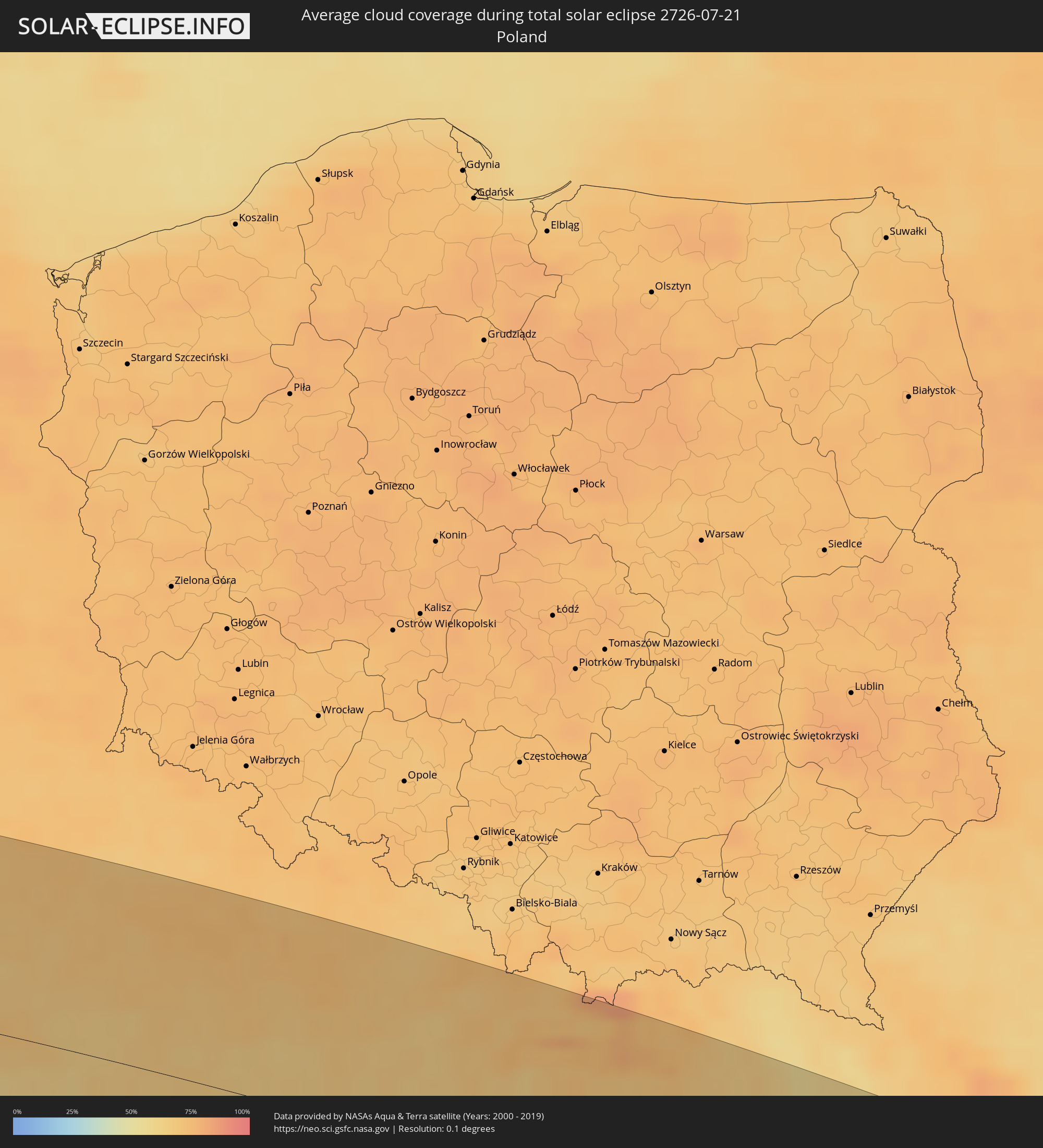
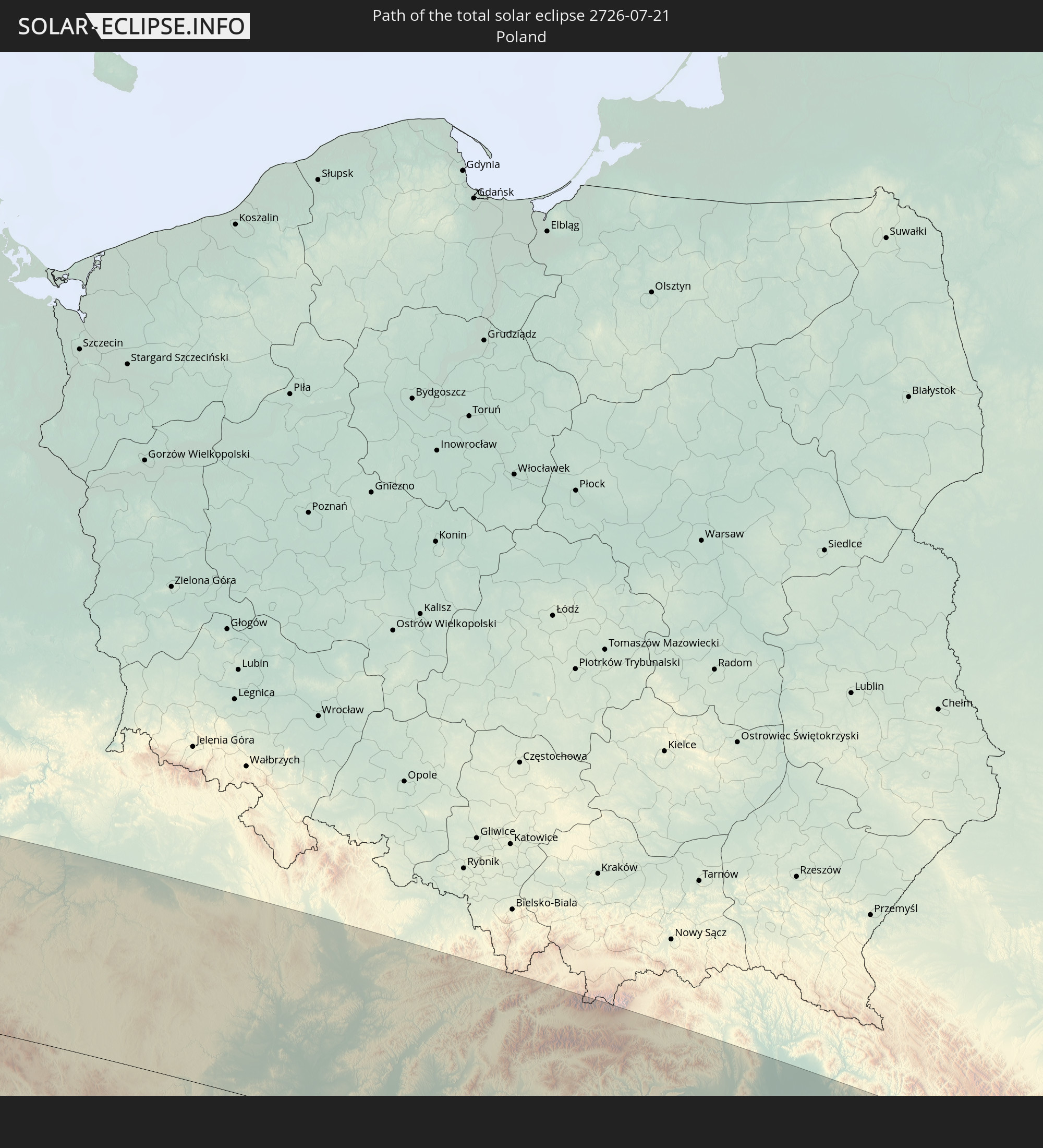 Polen
Polen
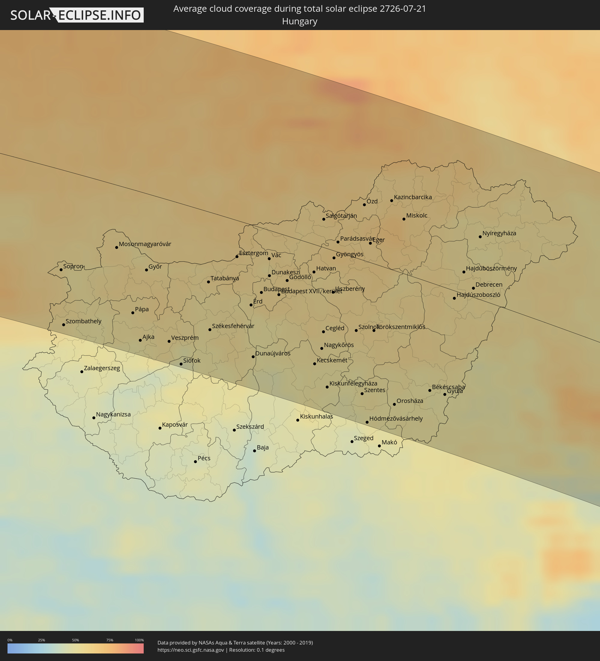
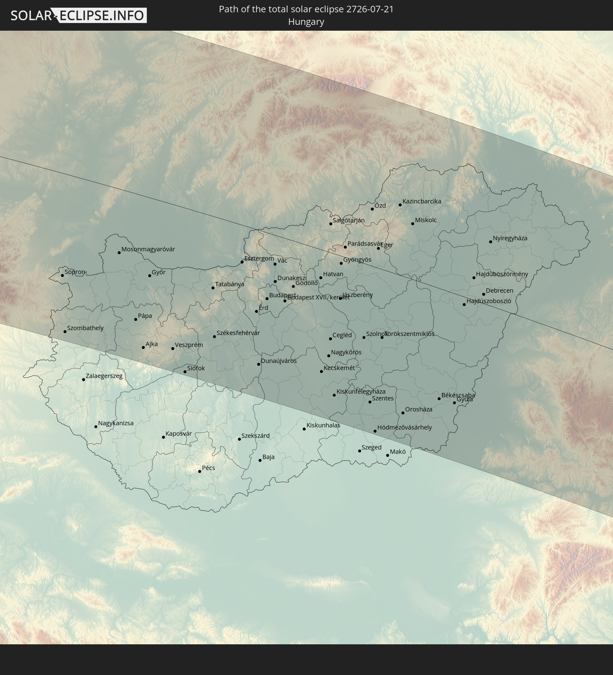 Ungarn
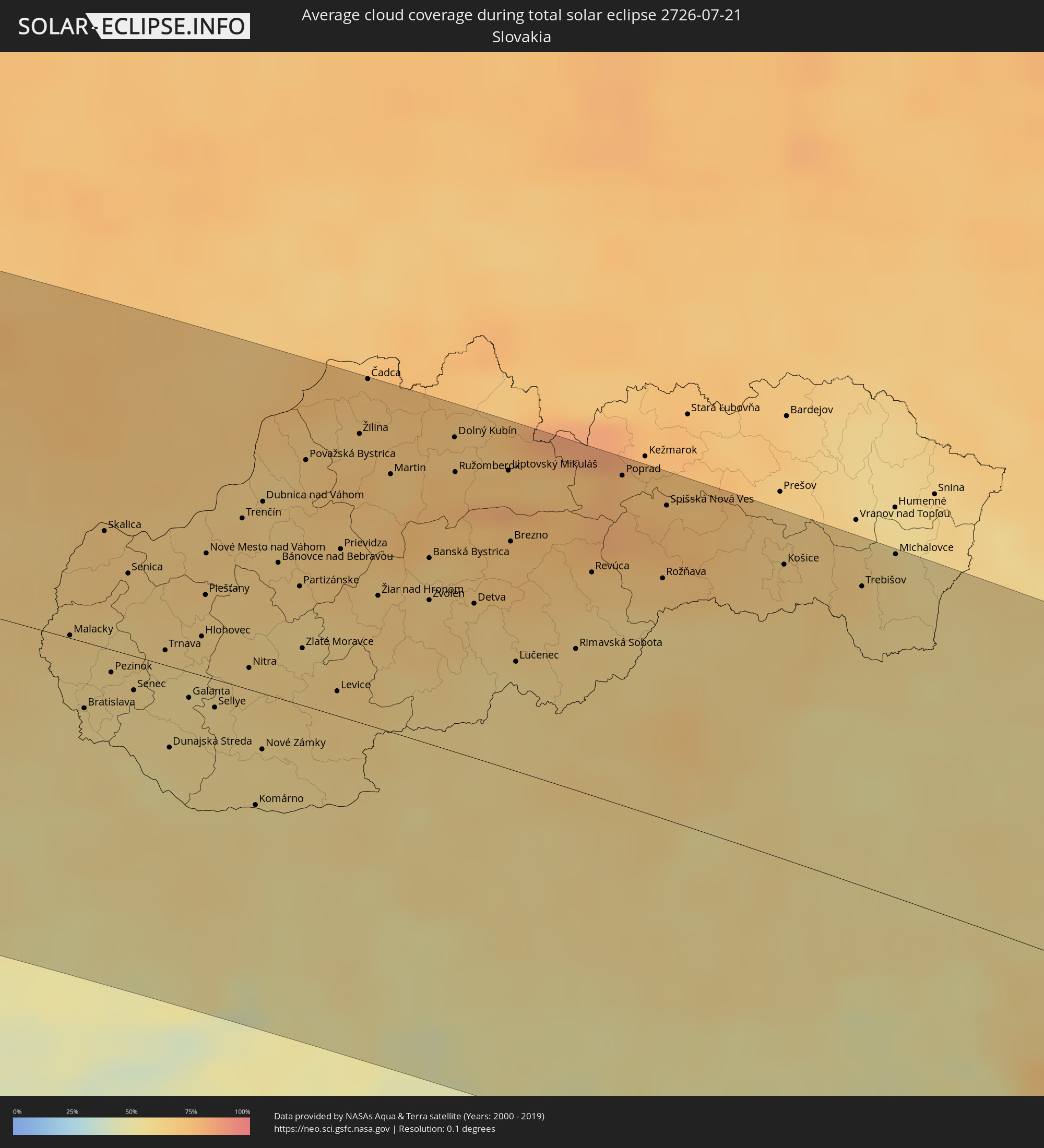
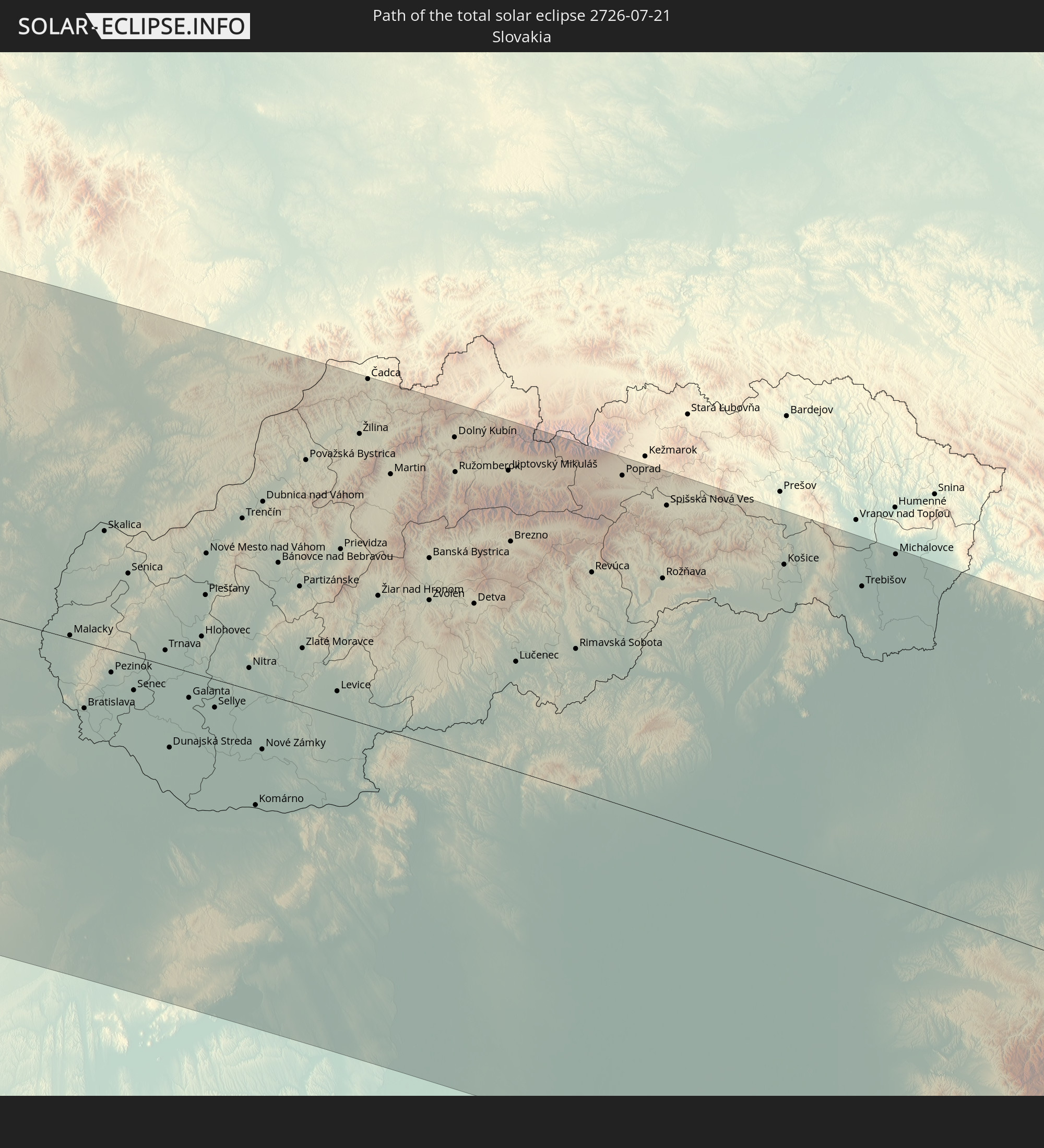 Slowakei
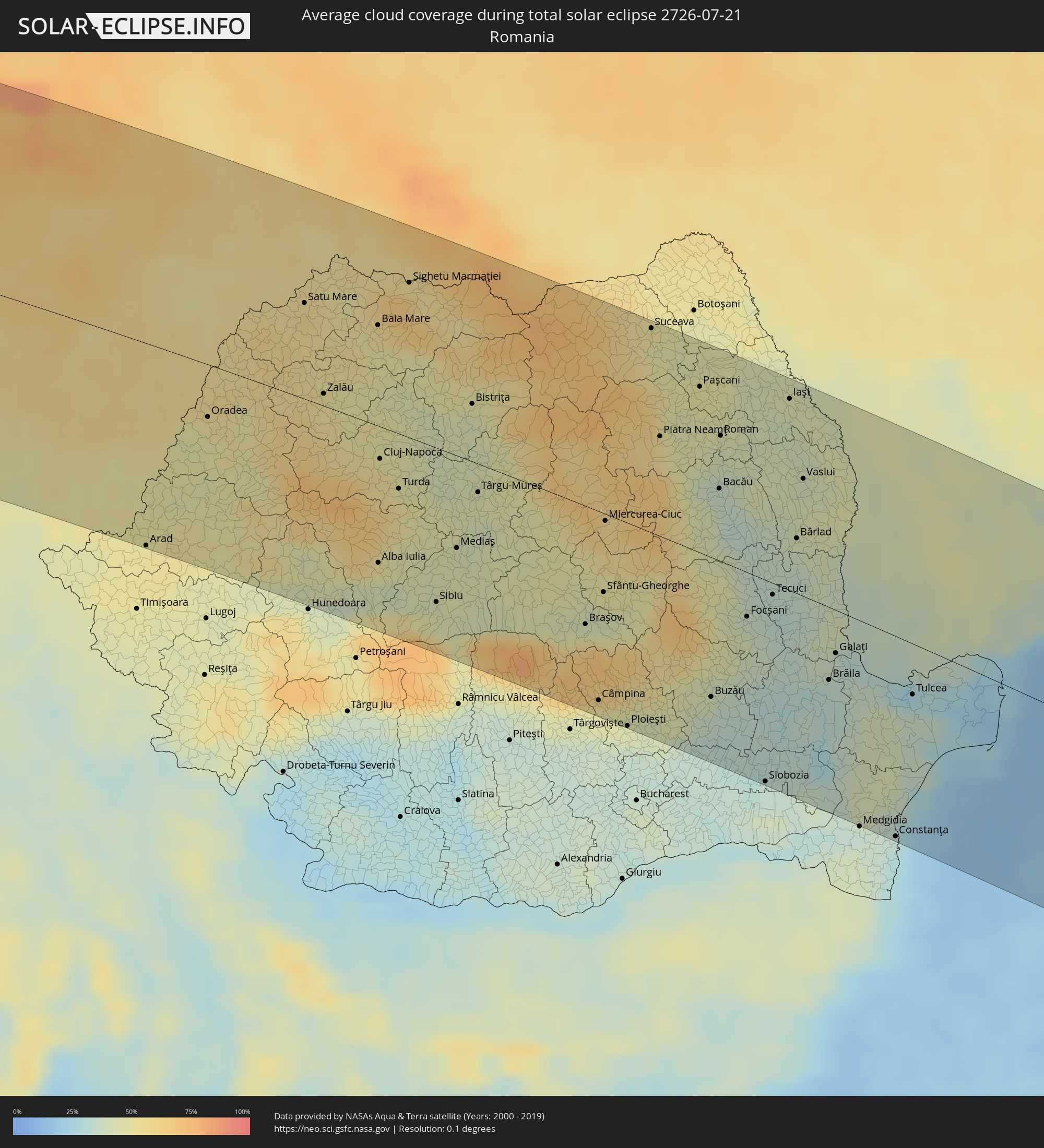
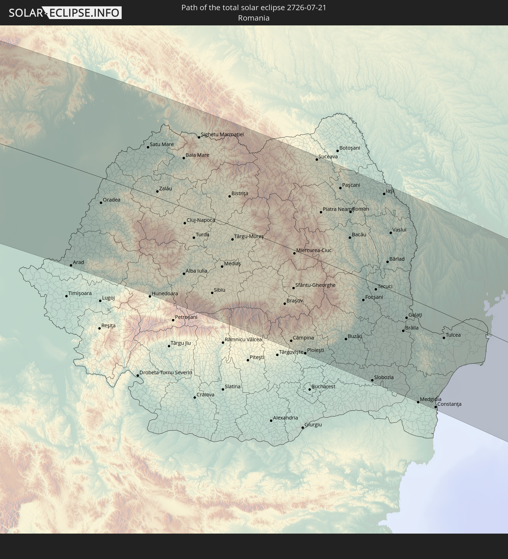 Rumänien
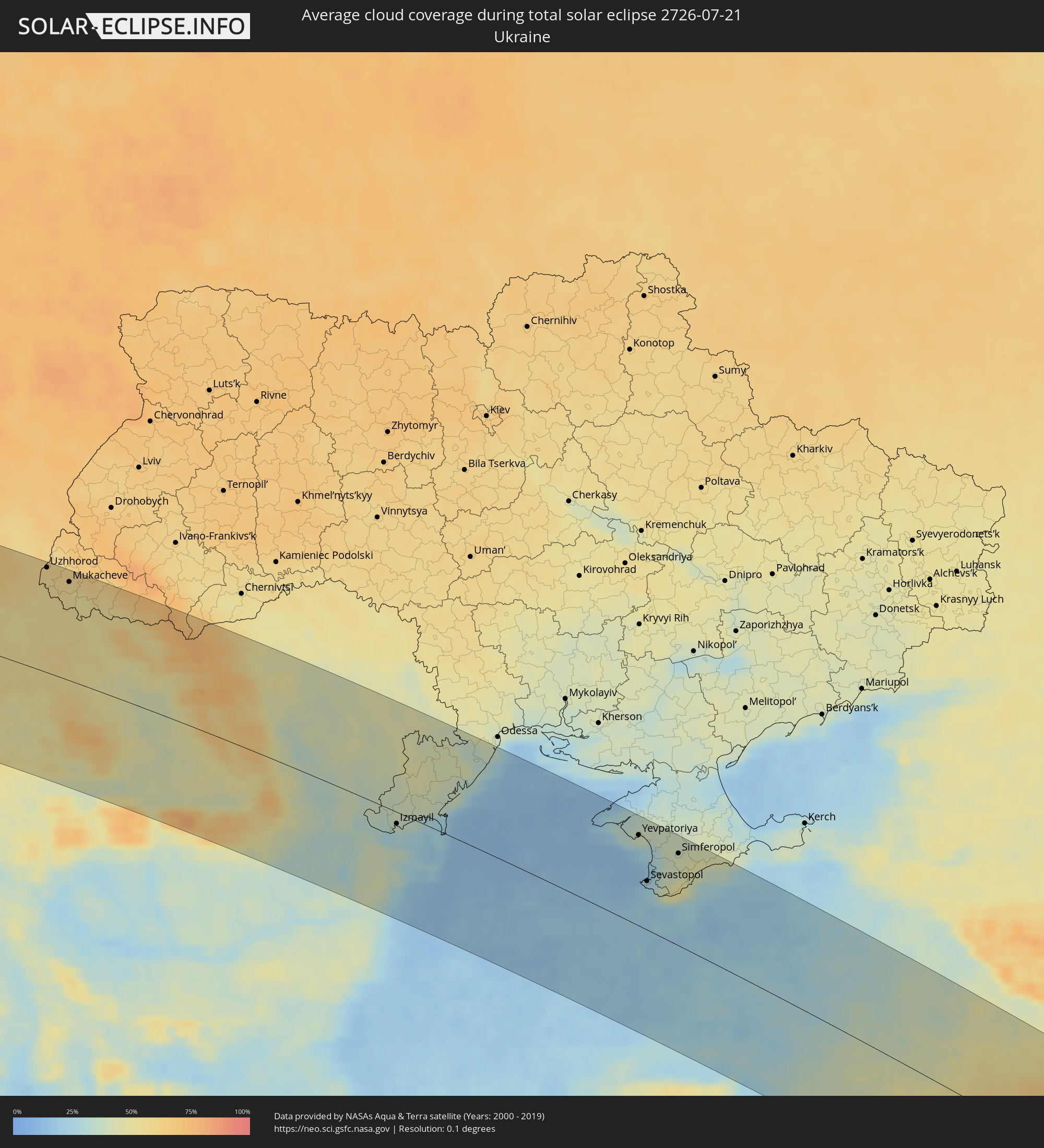
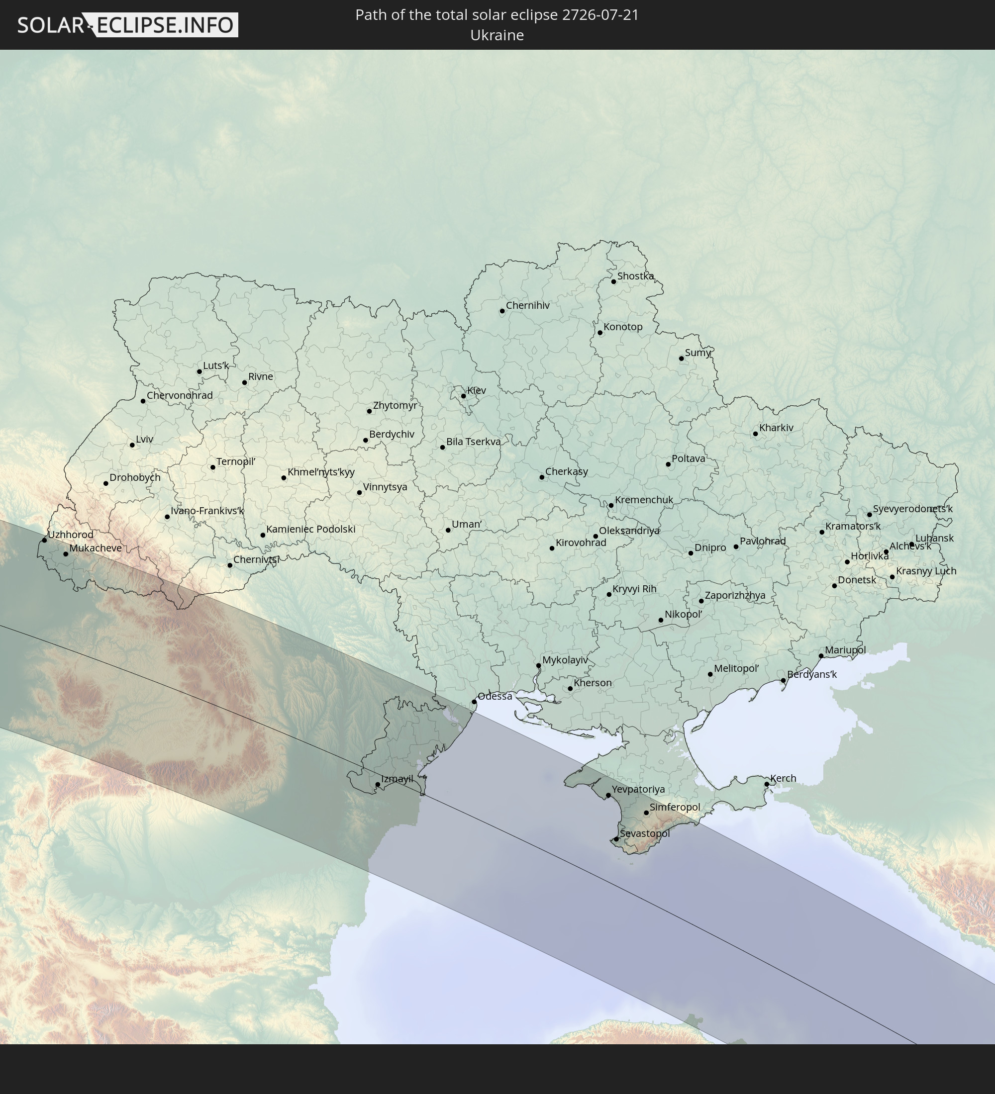 Ukraine
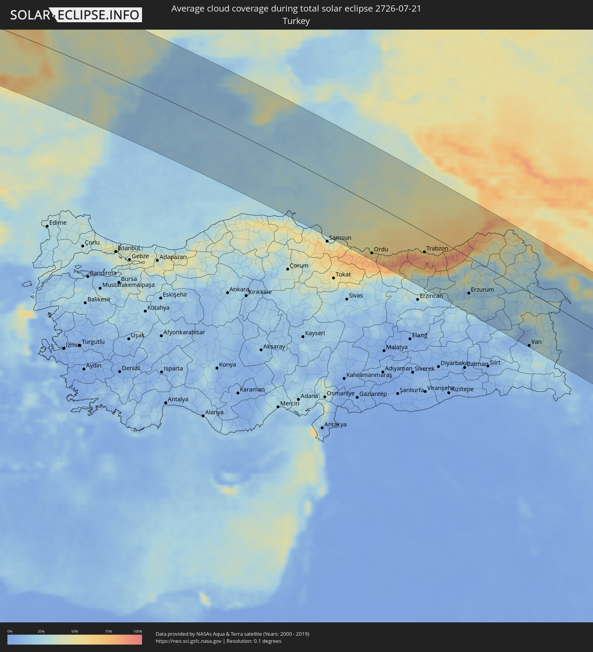
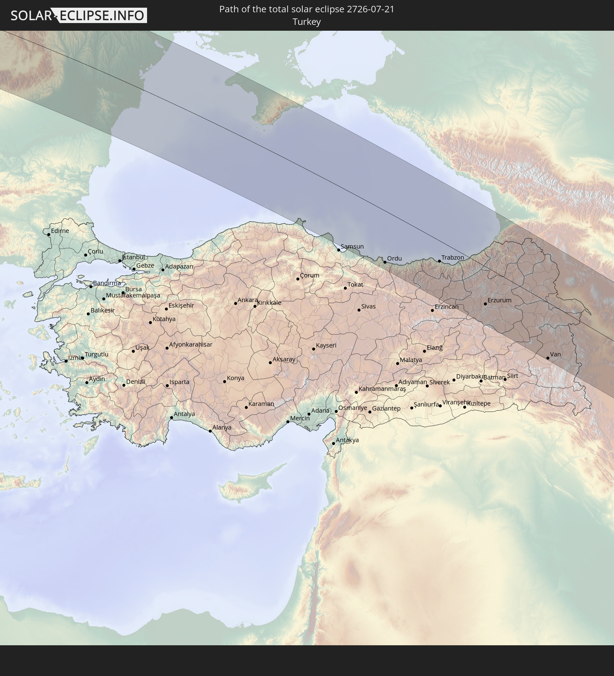 Türkei
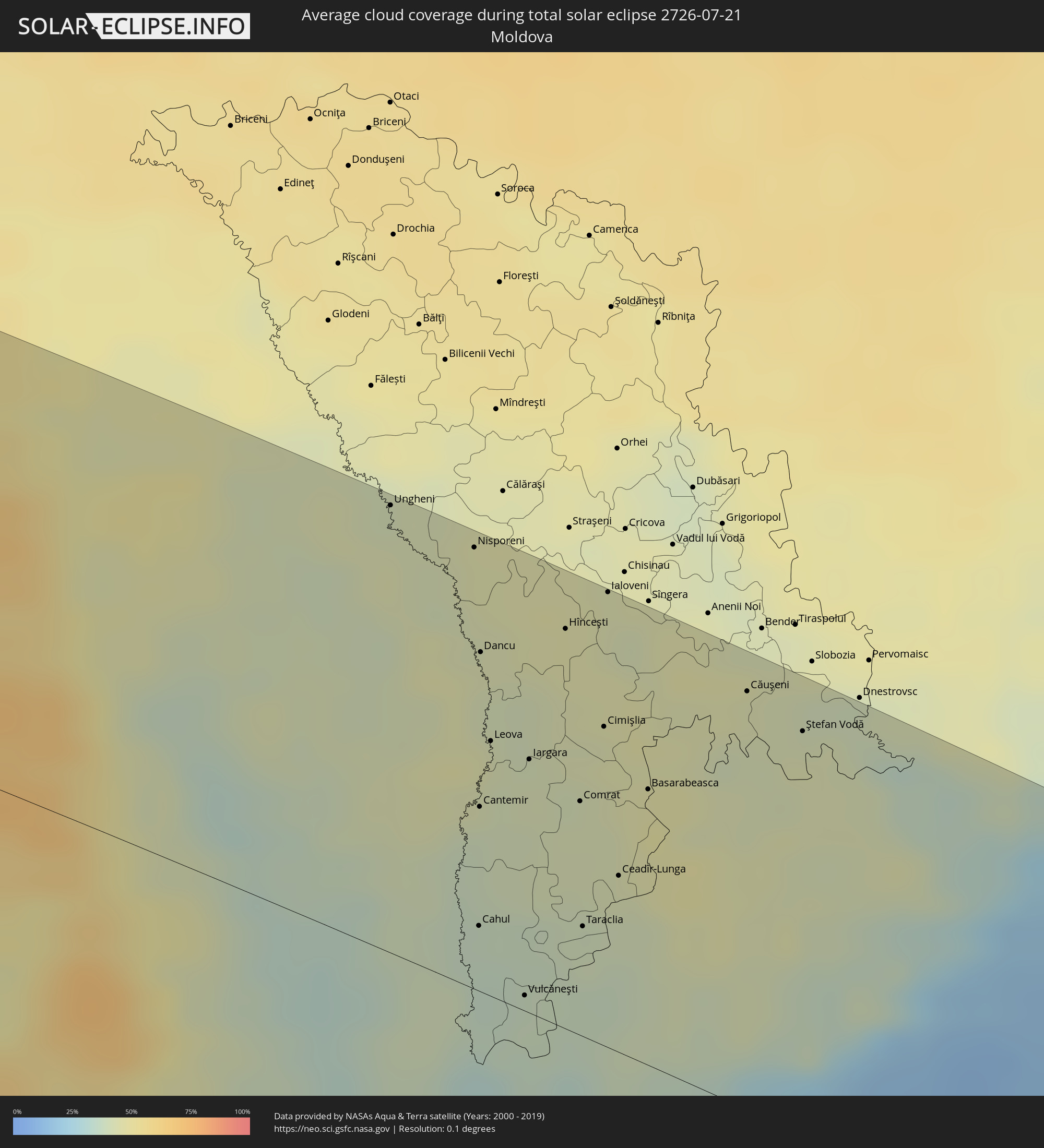
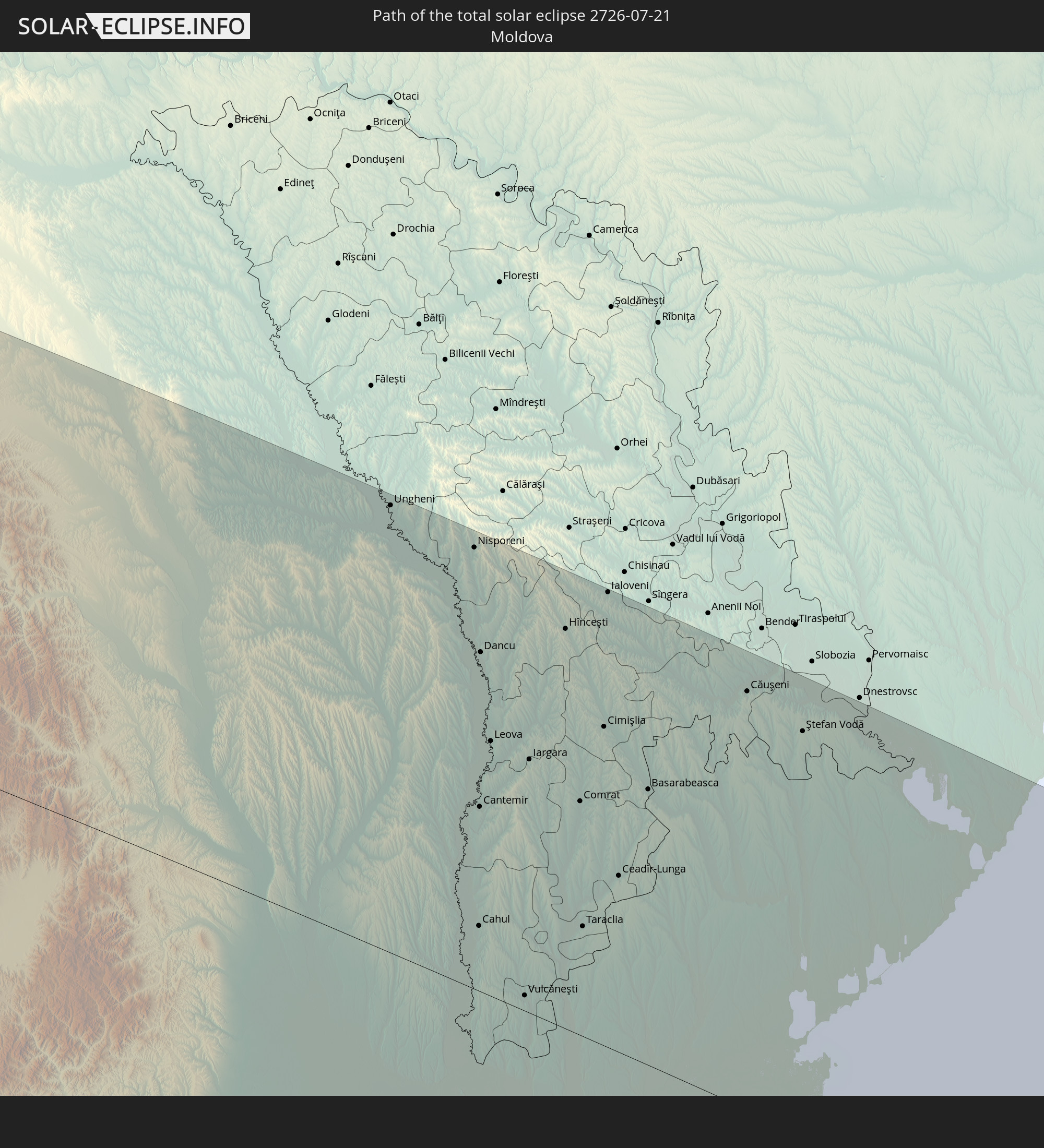 Moldawien
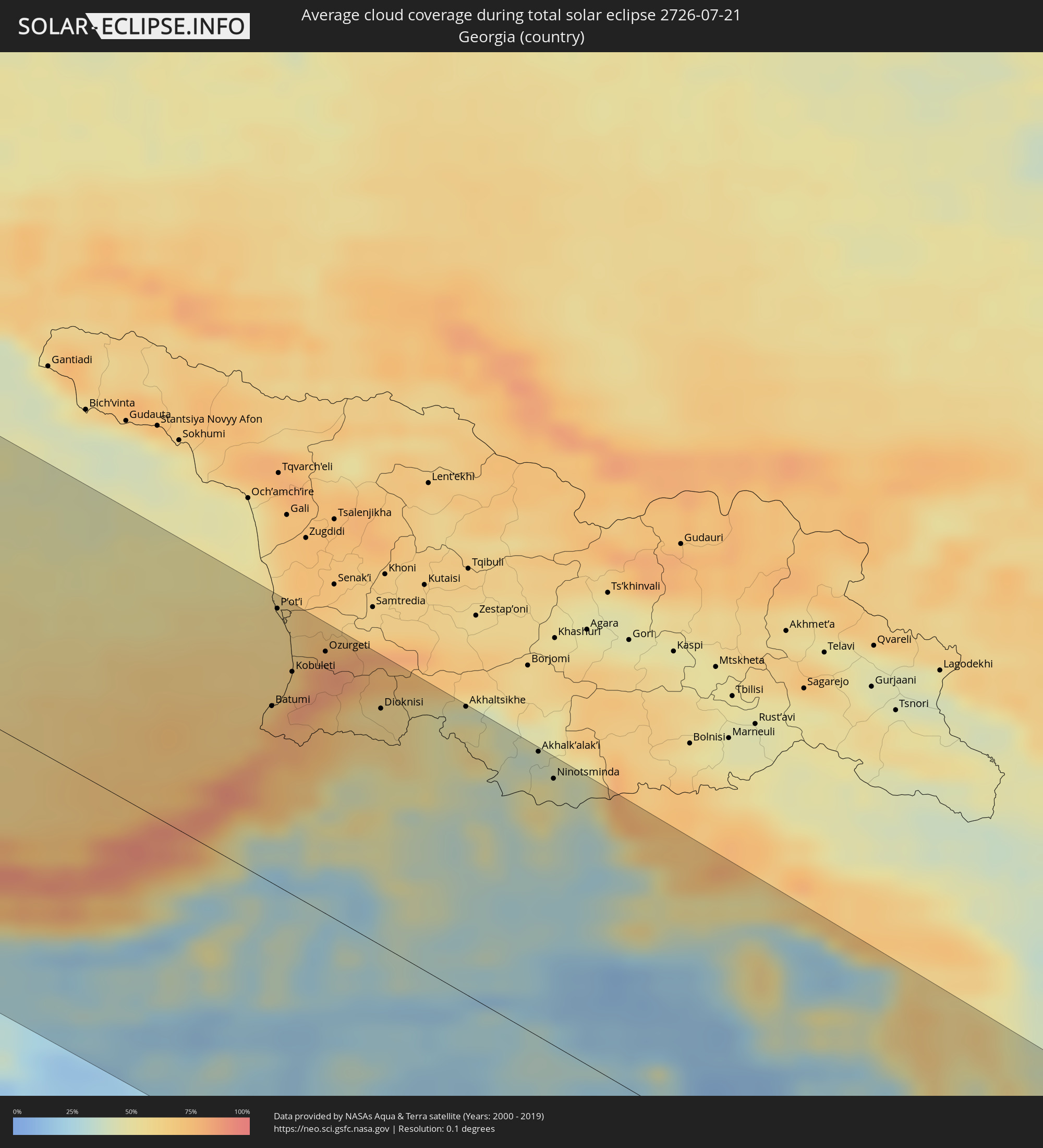
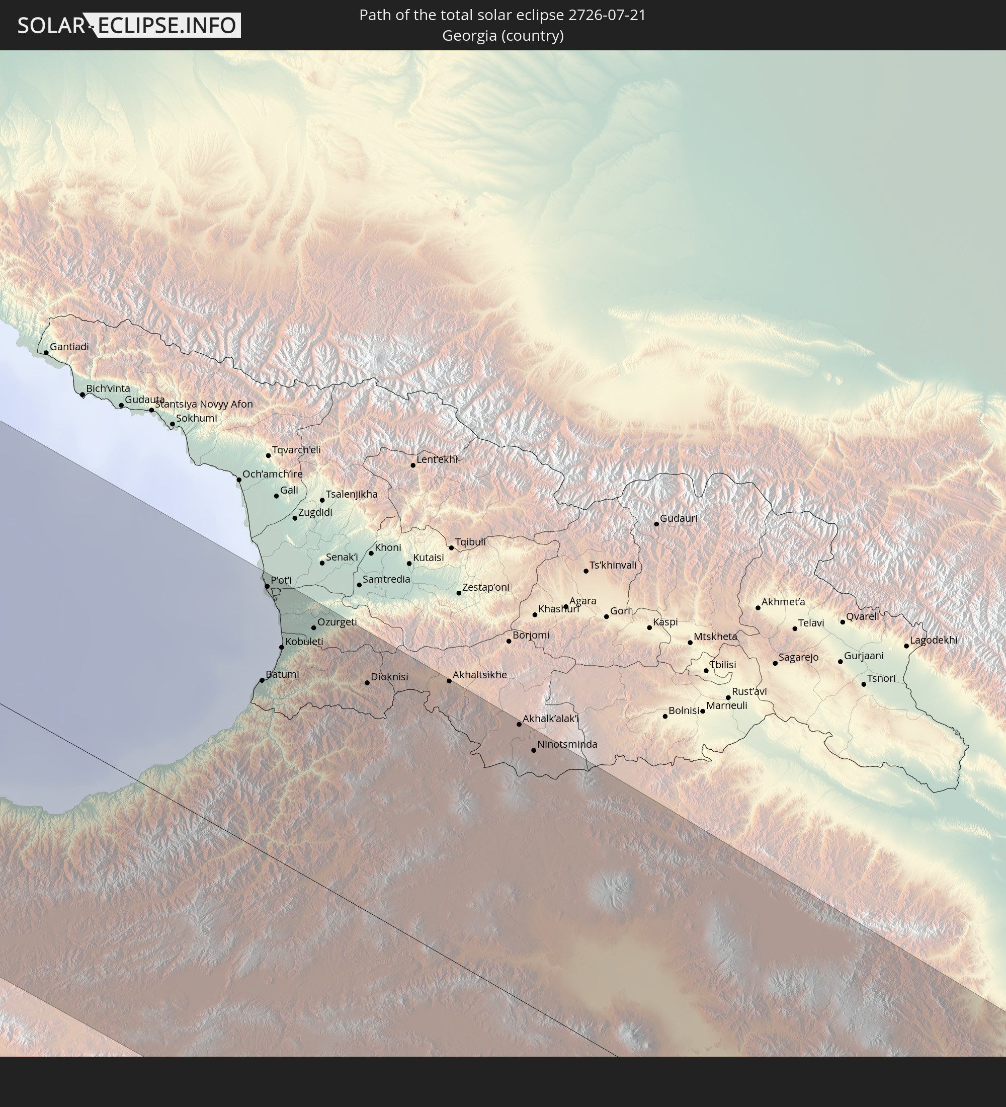 Georgien
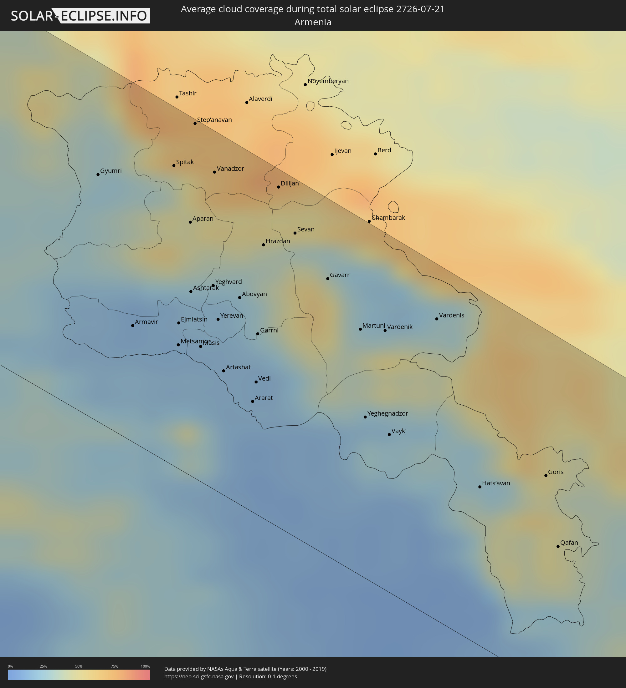
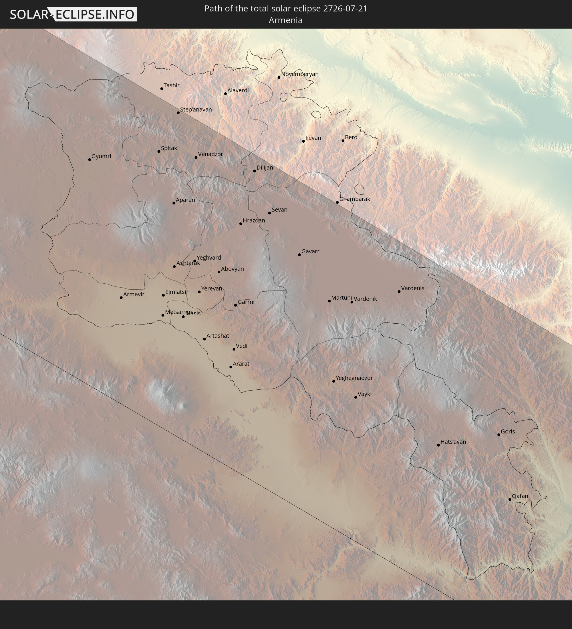 Armenien
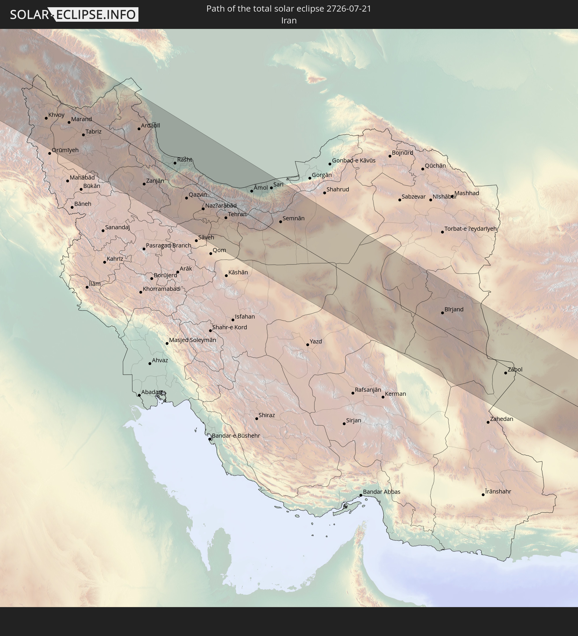 Iran
Iran
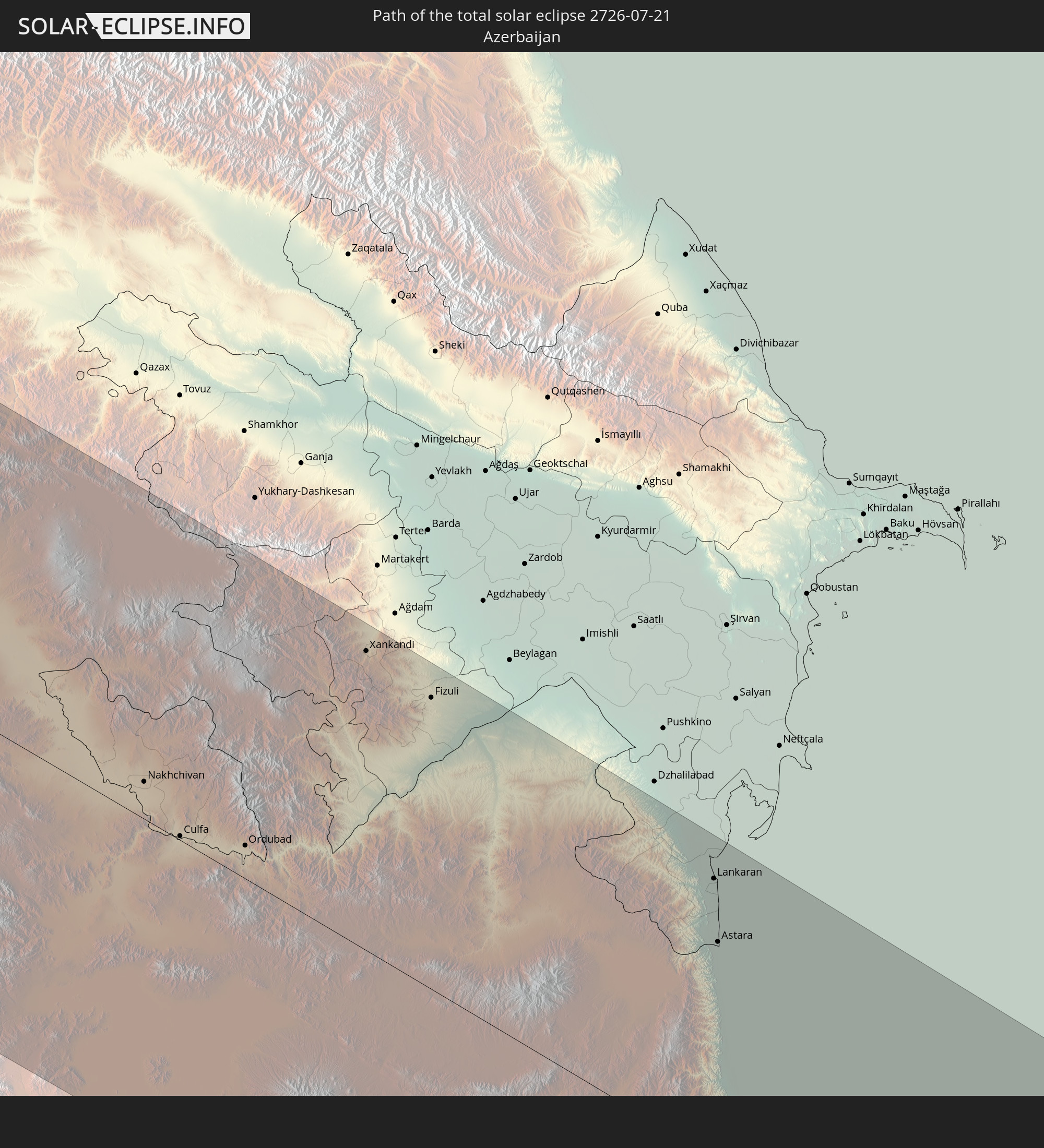 Aserbaidschan
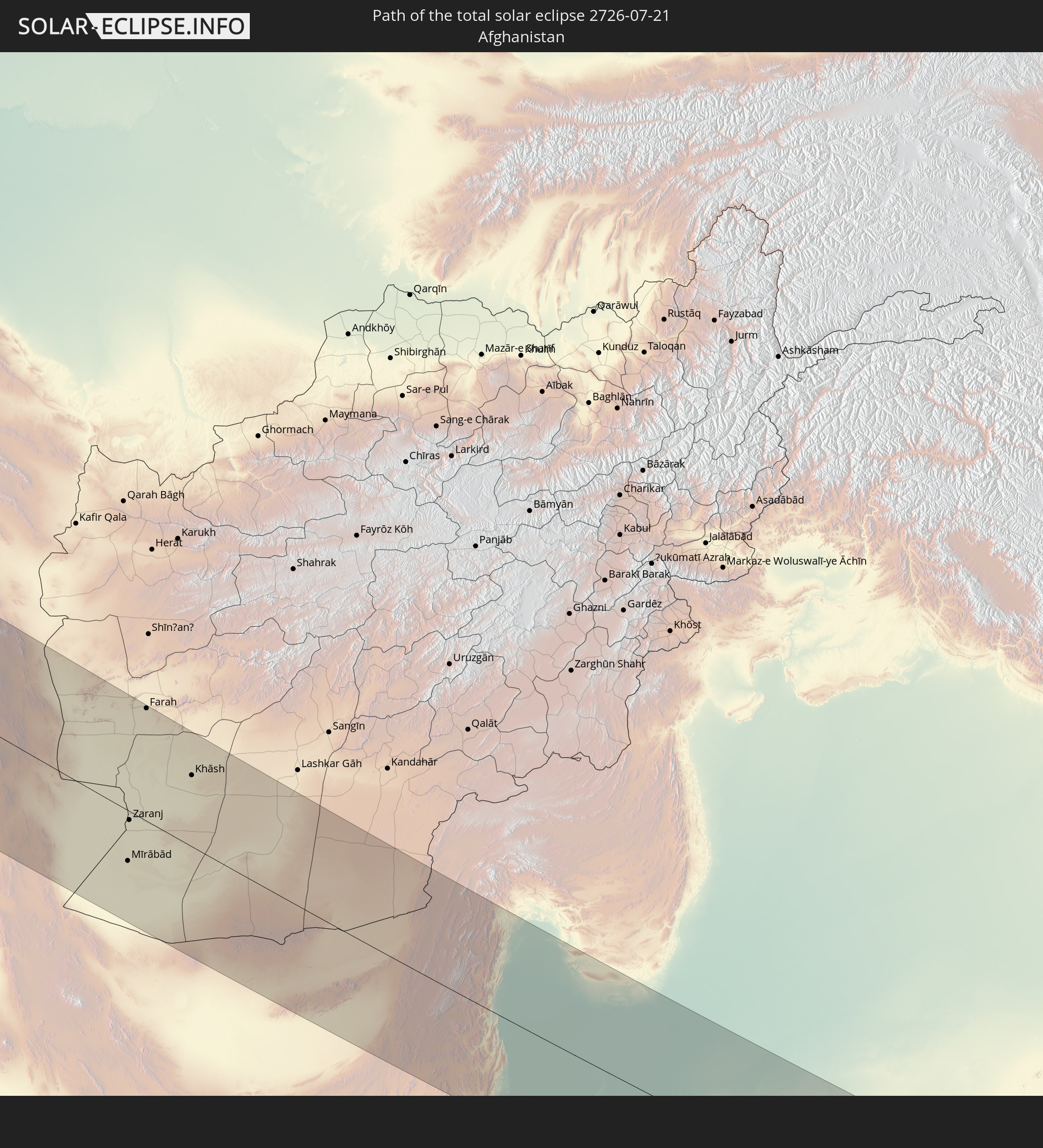 Afghanistan
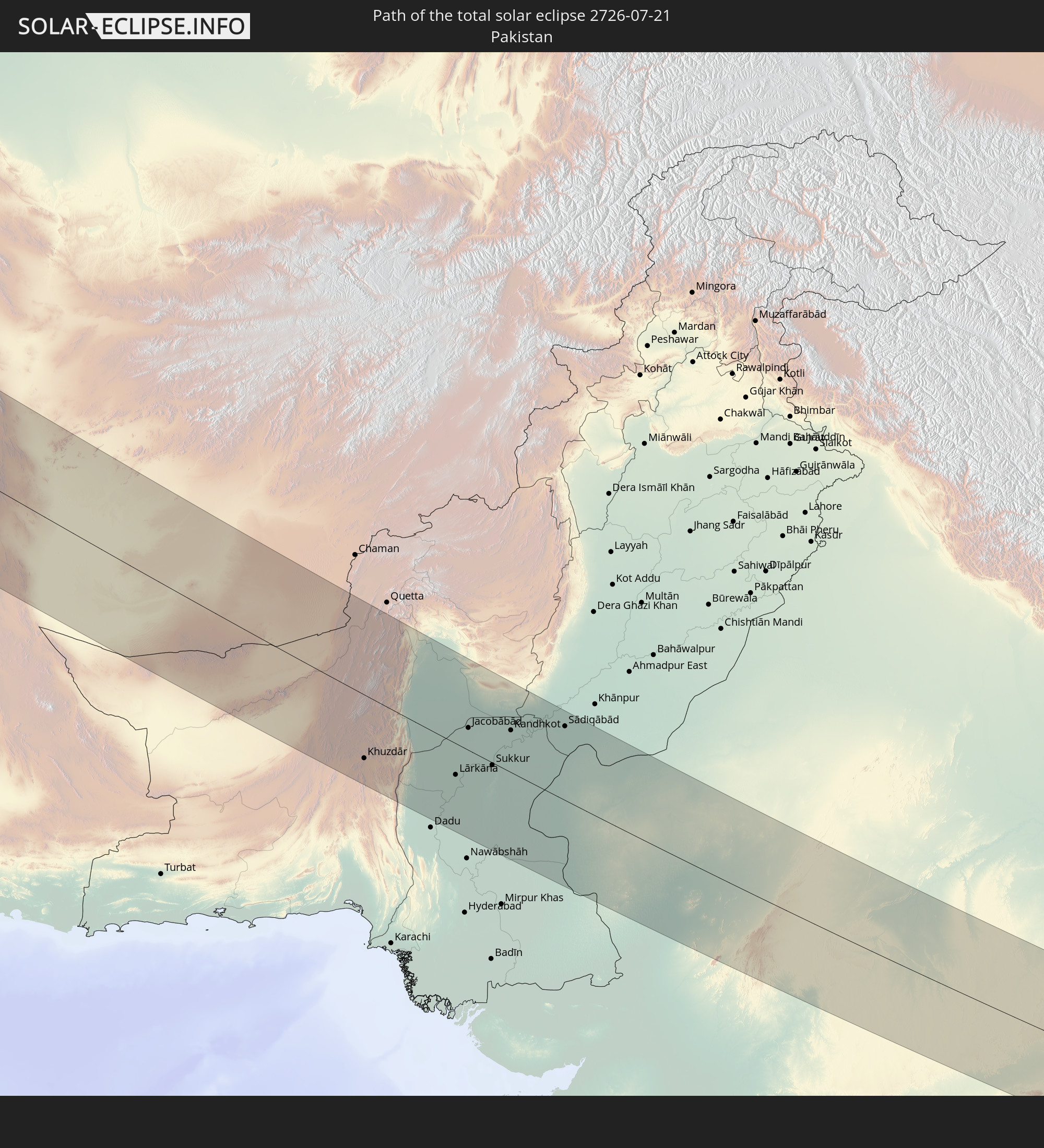 Pakistan
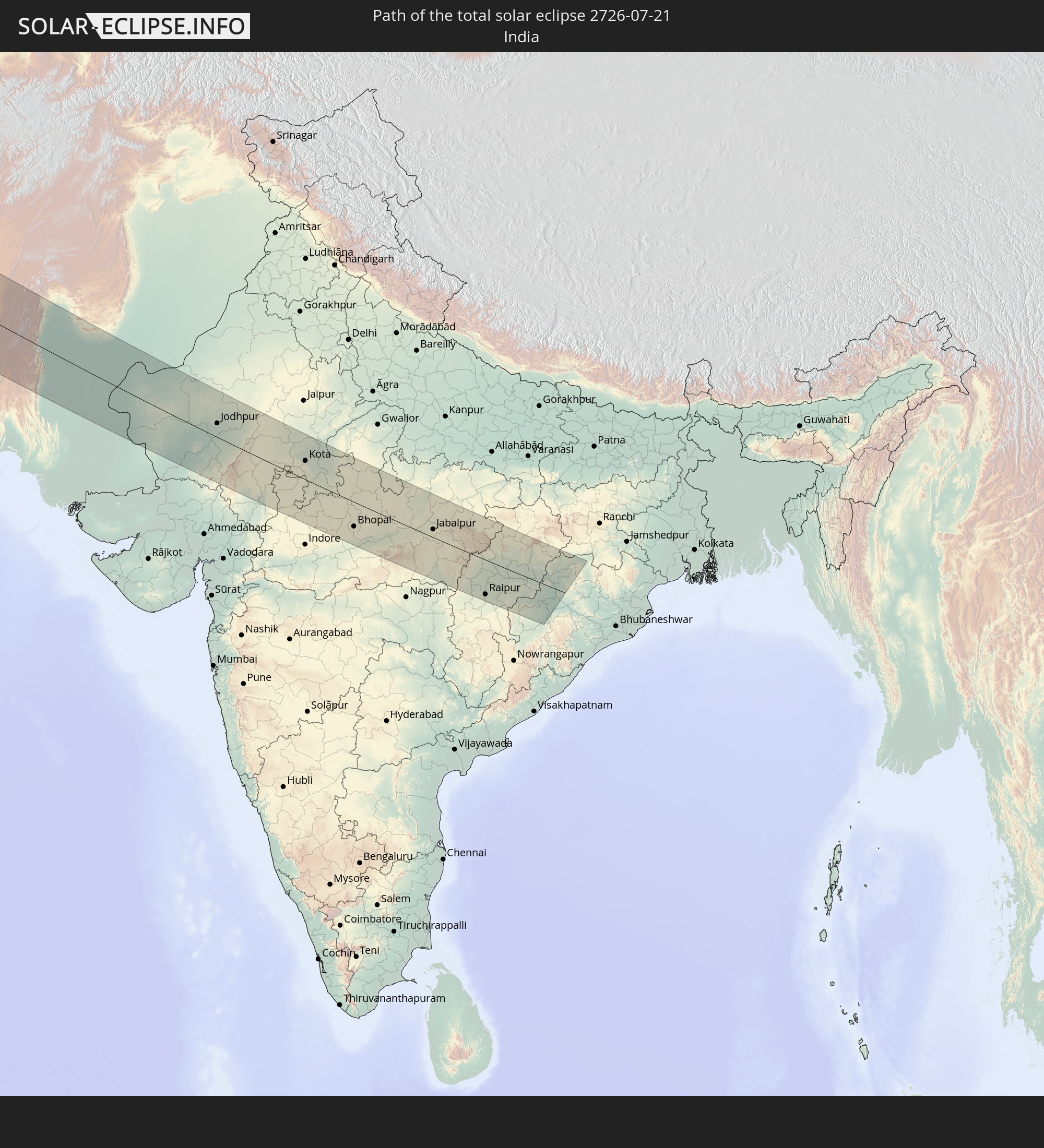 Indien
In den folgenden Ländern ist die Sonnenfinsternis partiell zu sehen
 Russland
 Vereinigte Staaten
 Kanada
 Grönland
 Bermuda
 Antigua und Barbuda
 Guadeloupe
 Barbados
 Suriname
 Saint-Pierre und Miquelon
 Französisch-Guayana
 Portugal
 Kap Verde
 Island
 Spanien
 Mauretanien
 Marokko
 Mali
Mali
 Irland
 Spitzbergen
 Algerien
 Vereinigtes Königreich
 Färöer
 Gibraltar
 Frankreich
 Isle of Man
 Guernsey
 Jersey
 Niger
Niger
 Andorra
 Belgien
 Niederlande
 Norwegen
 Luxemburg
 Deutschland
 Schweiz
 Italien
 Monaco
 Tunesien
 Dänemark
 Libyen
 Liechtenstein
 Österreich
 Schweden
 Tschechien
 San Marino
 Vatikanstadt
 Slowenien
 Tschad
 Kroatien
 Polen
Polen
 Malta
Malta
 Bosnien und Herzegowina
 Ungarn
 Slowakei
 Montenegro
 Serbien
 Albanien
 Åland Islands
 Griechenland
 Rumänien
 Mazedonien
 Finnland
 Litauen
 Lettland
 Estland
 Sudan
Sudan
 Ukraine
 Bulgarien
 Weißrussland
 Ägypten
 Türkei
 Moldawien
 Republik Zypern
 Äthiopien
 Kenia
Kenia
 Staat Palästina
 Israel
 Saudi-Arabien
 Jordanien
 Libanon
 Syrien
 Eritrea
 Irak
Irak
 Georgien
 Somalia
 Dschibuti
 Jemen
Jemen
 Armenien
 Iran
Iran
 Aserbaidschan
 Kasachstan
 Kuwait
 Bahrain
 Katar
Katar
 Vereinigte Arabische Emirate
 Oman
Oman
 Turkmenistan
 Usbekistan
 Afghanistan
 Pakistan
 Tadschikistan
 Indien
 Kirgisistan
 Malediven
 Volksrepublik China
 Nepal
Nepal
 Mongolei
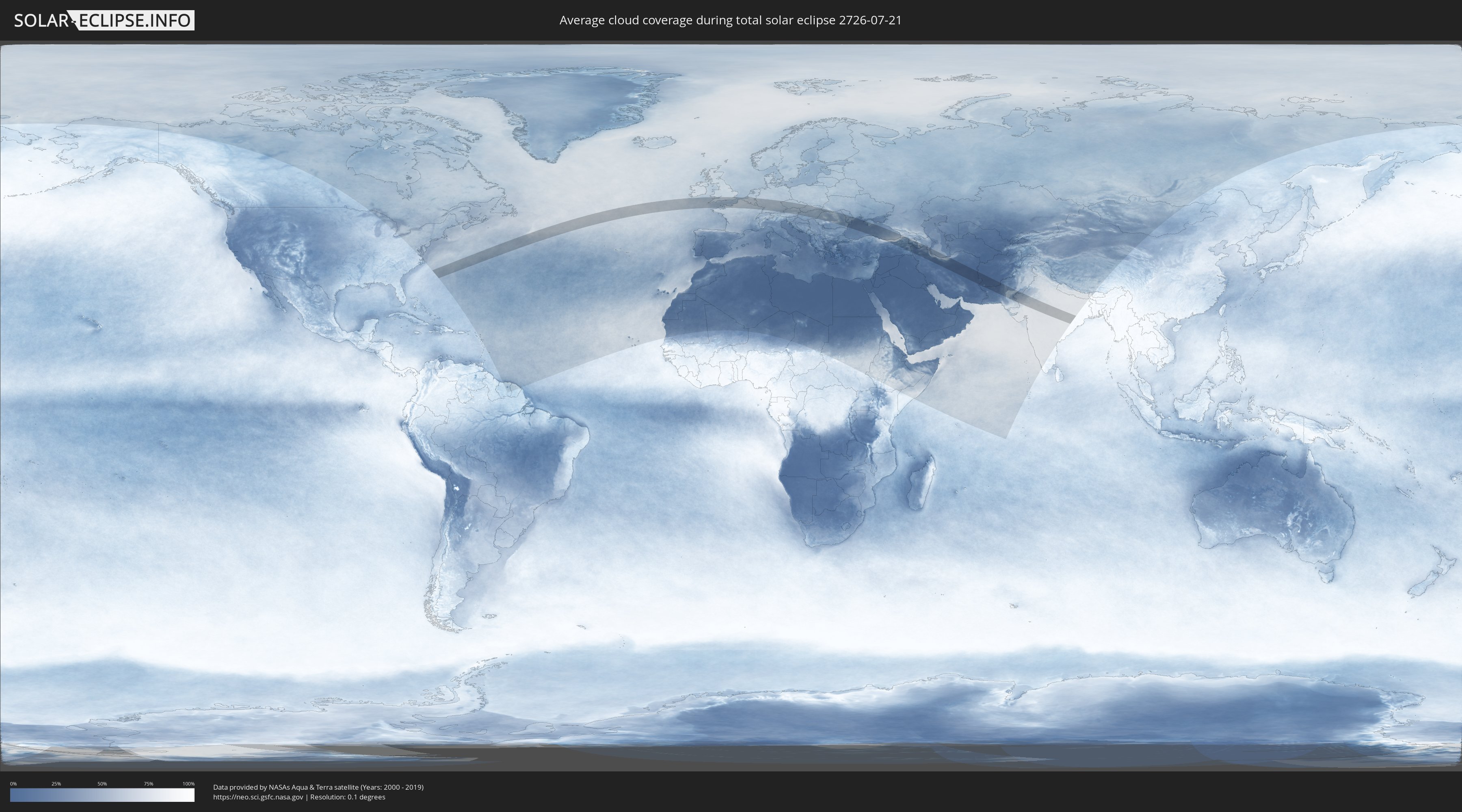
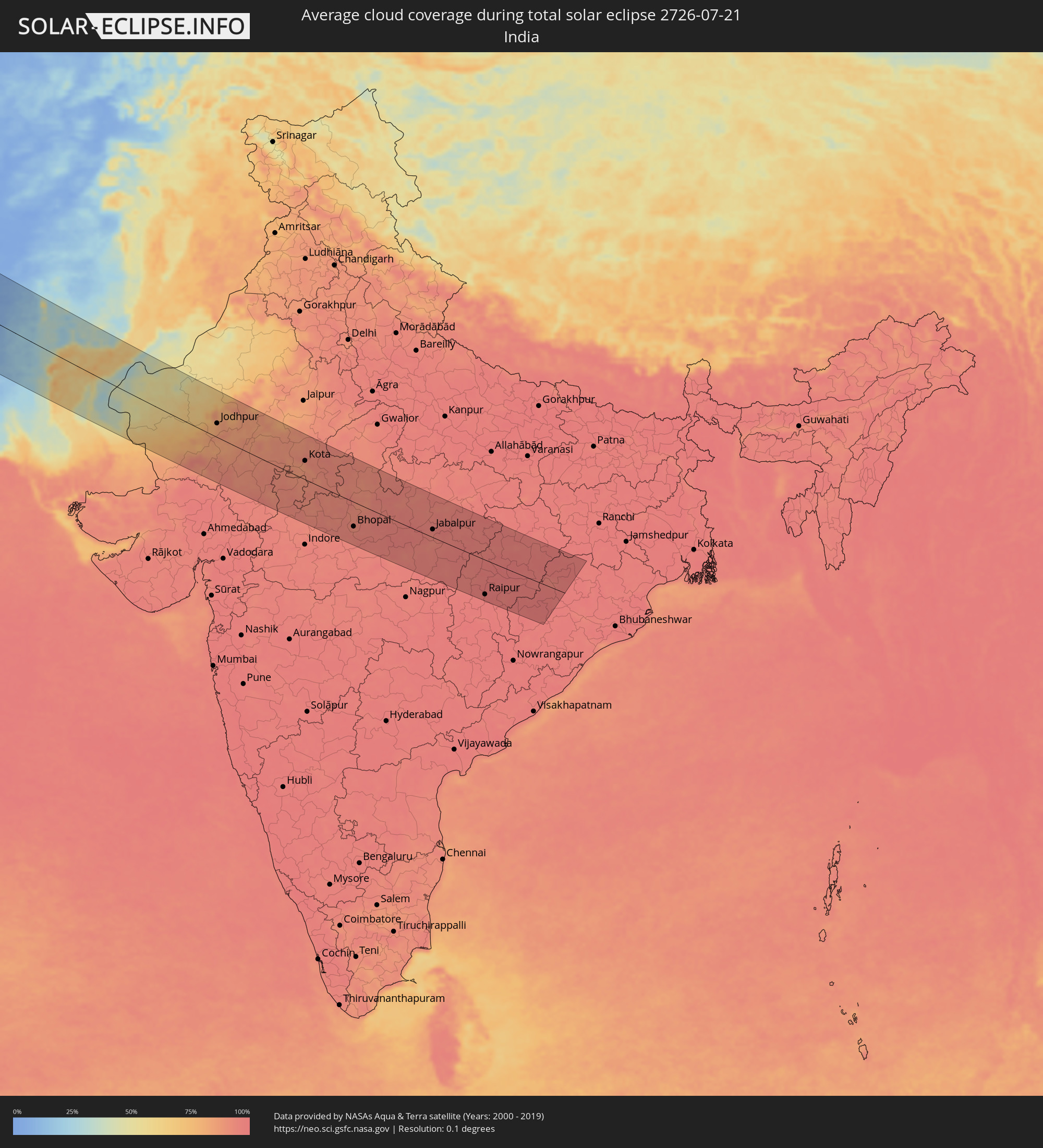
Wie wird das Wetter während der totalen Sonnenfinsternis am 21.07.2726?
Wo ist der beste Ort, um die totale Sonnenfinsternis vom 21.07.2726 zu beobachten?
Die folgenden Karten zeigen die durchschnittliche Bewölkung für den Tag, an dem die totale Sonnenfinsternis
stattfindet. Mit Hilfe der Karten lässt sich der Ort entlang des Finsternispfades eingrenzen,
der die besten Aussichen auf einen klaren wolkenfreien Himmel bietet.
Trotzdem muss man immer lokale Gegenenheiten beachten und sollte sich genau über das Wetter an seinem
gewählten Beobachtungsort informieren.
Die Daten stammen von den beiden NASA-Satelliten
AQUA und TERRA
und wurden über einen Zeitraum von 19 Jahren (2000 - 2019) gemittelt.

Detaillierte Länderkarten
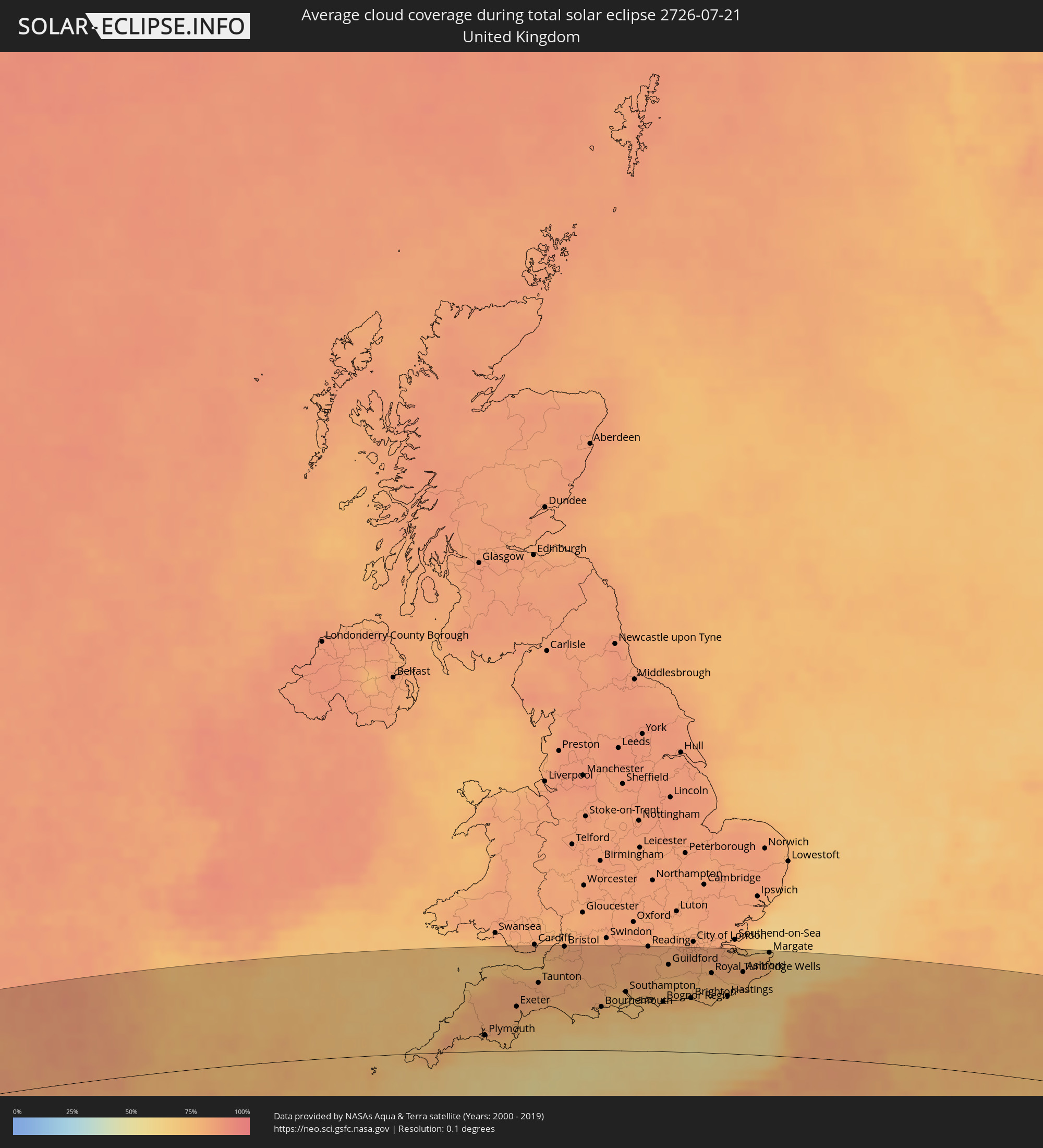 Vereinigtes Königreich
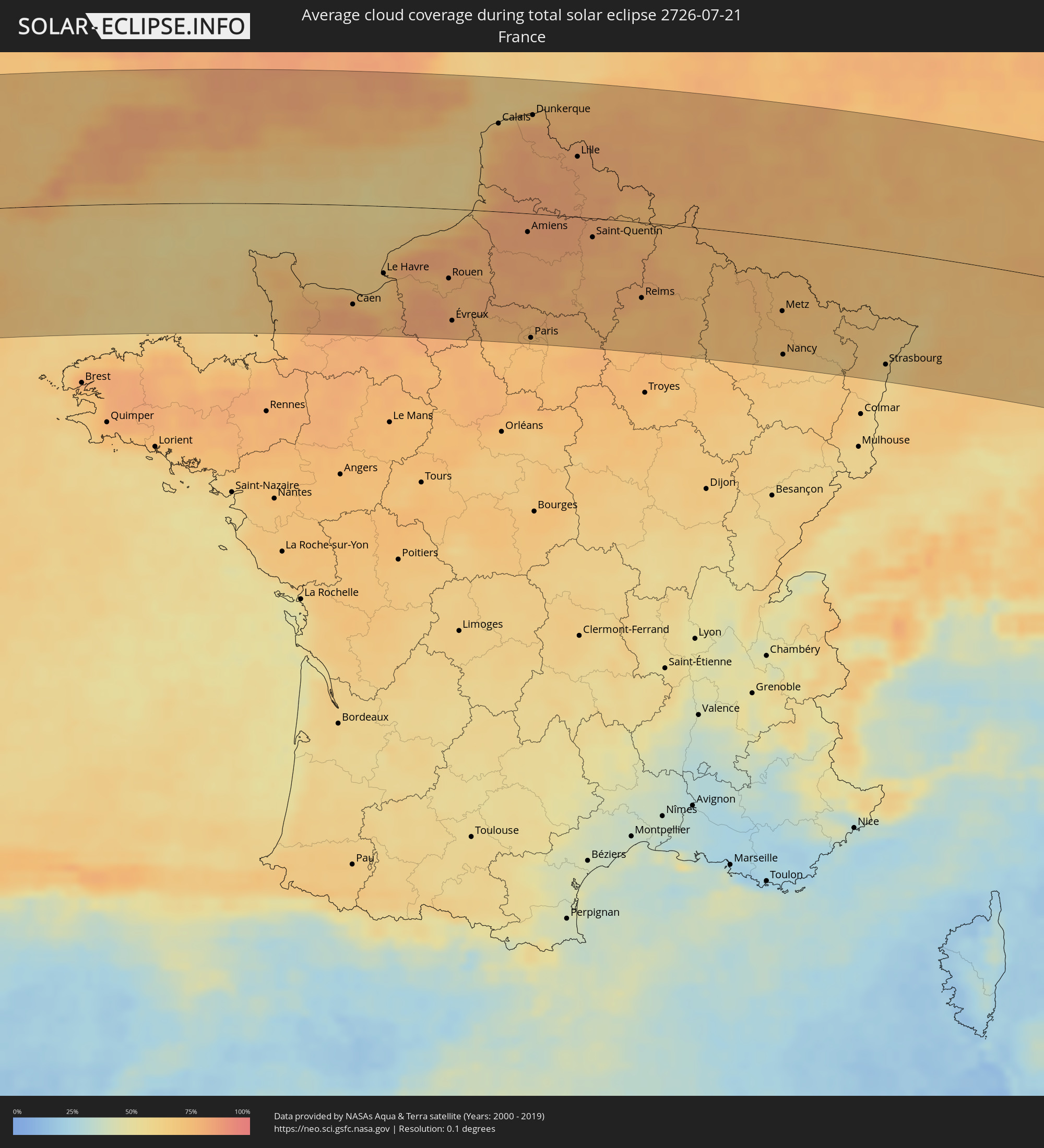 Frankreich
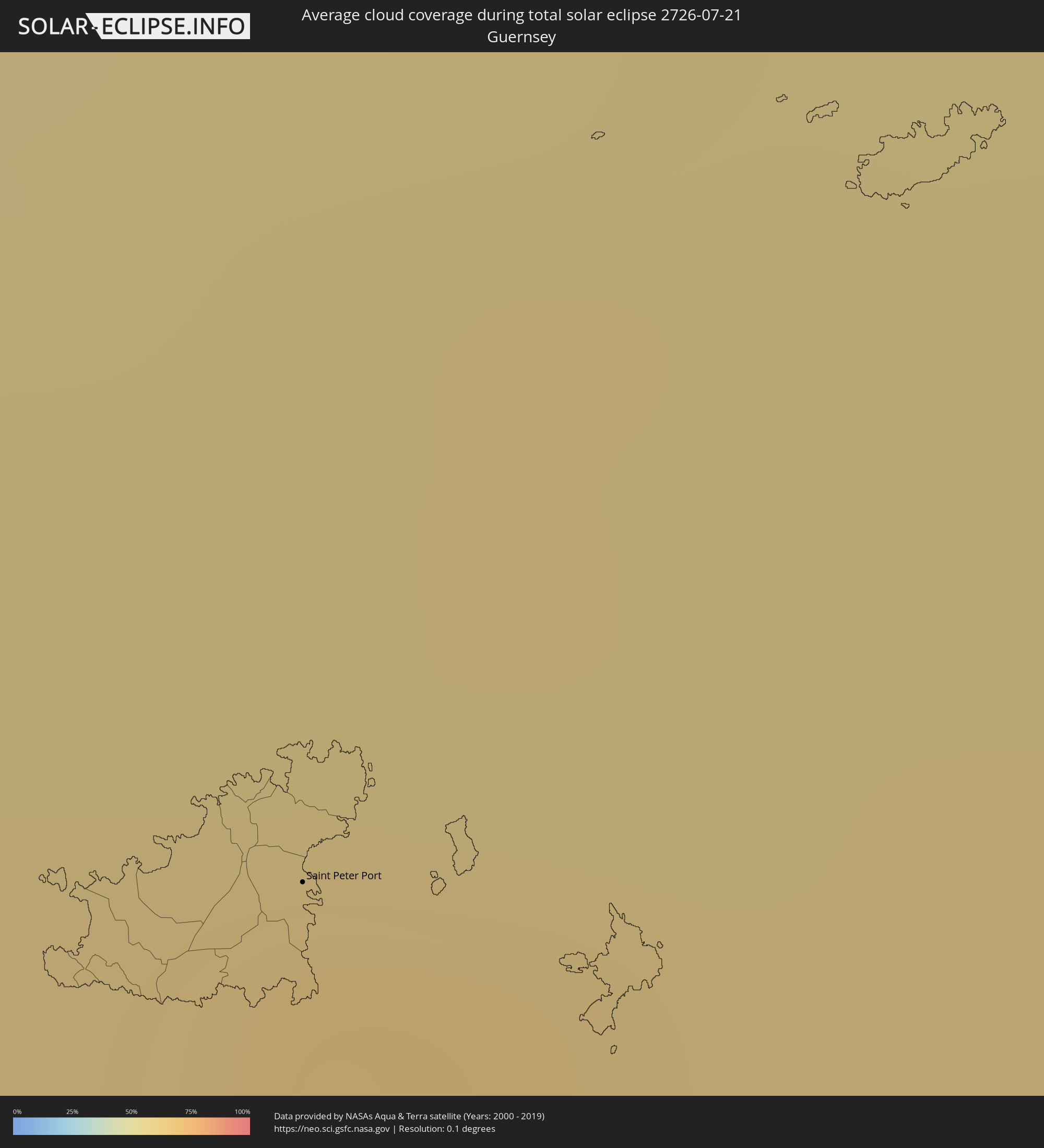 Guernsey
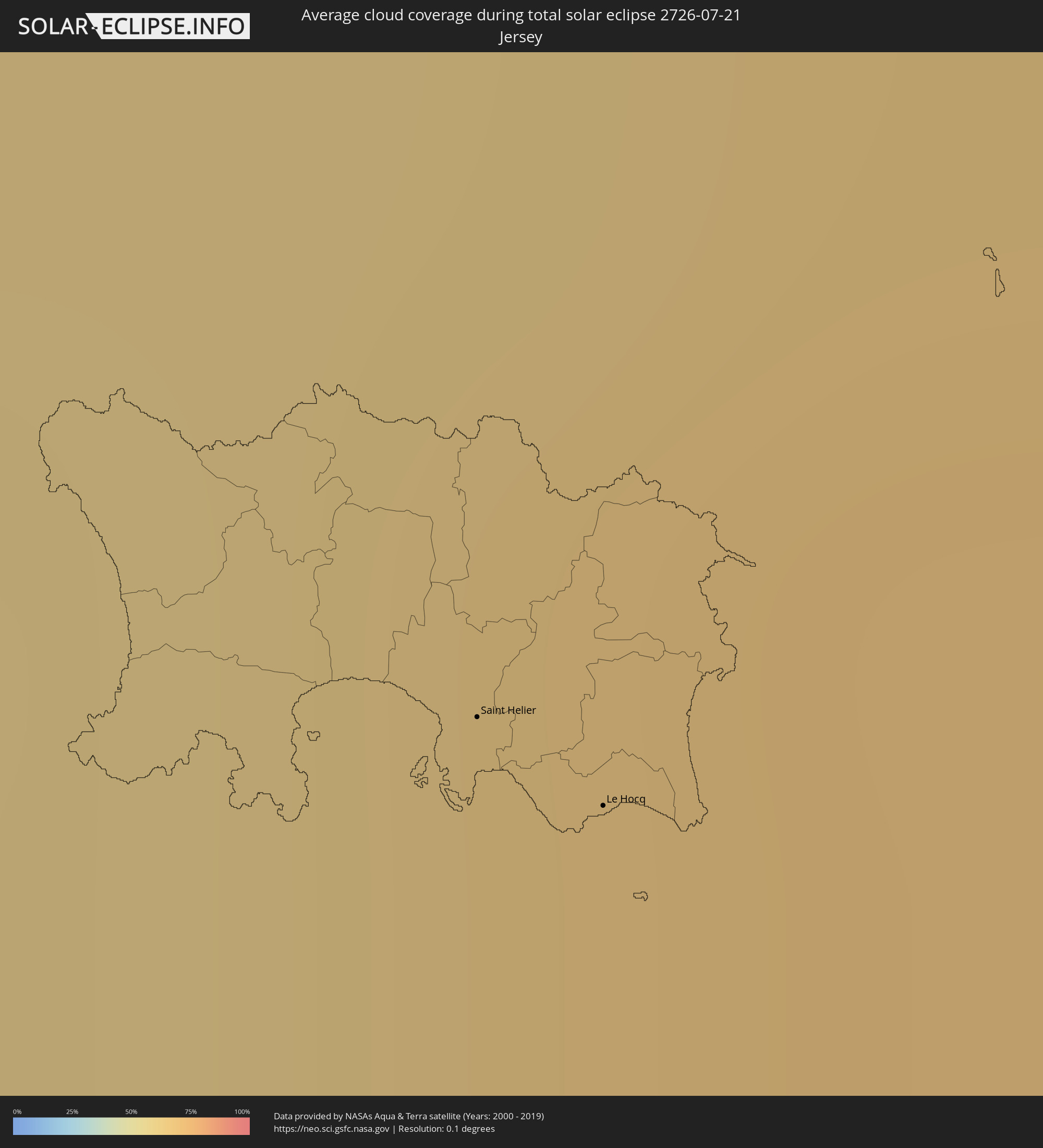 Jersey
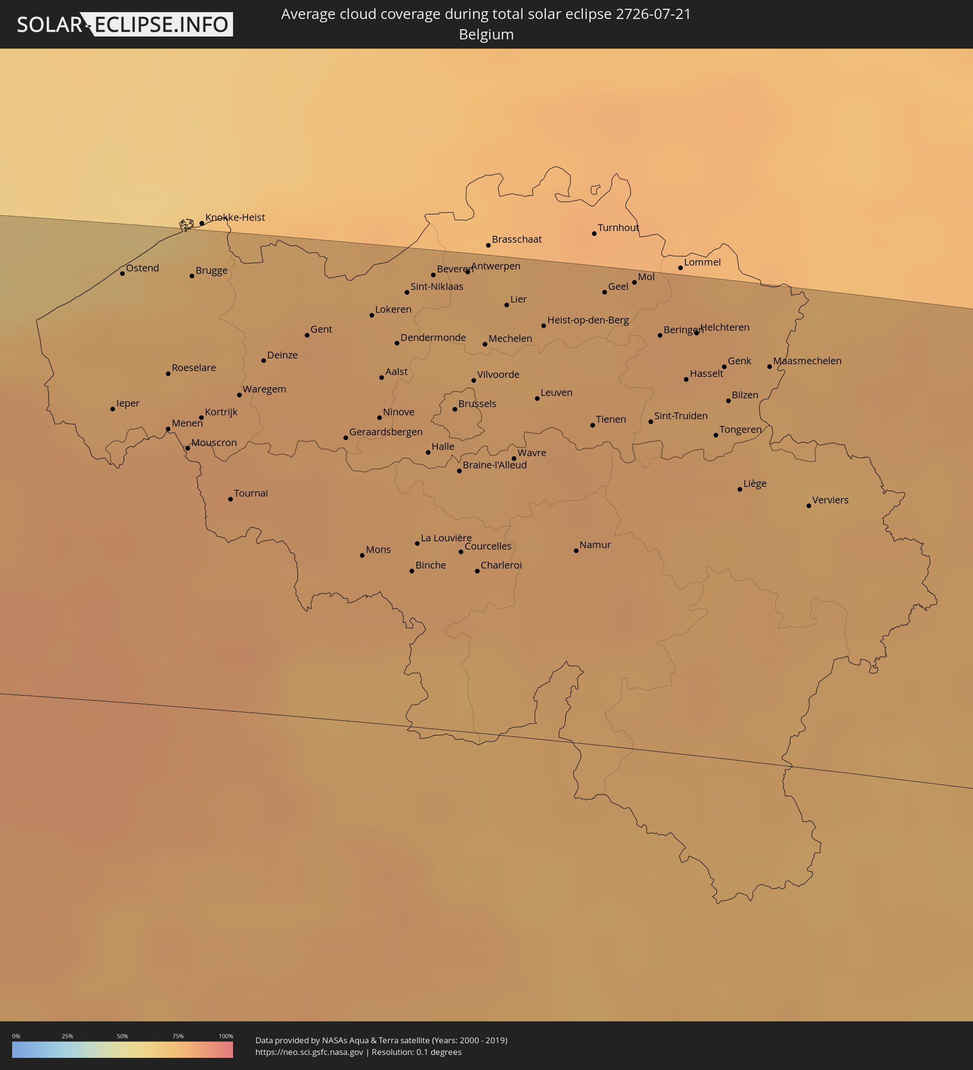 Belgien
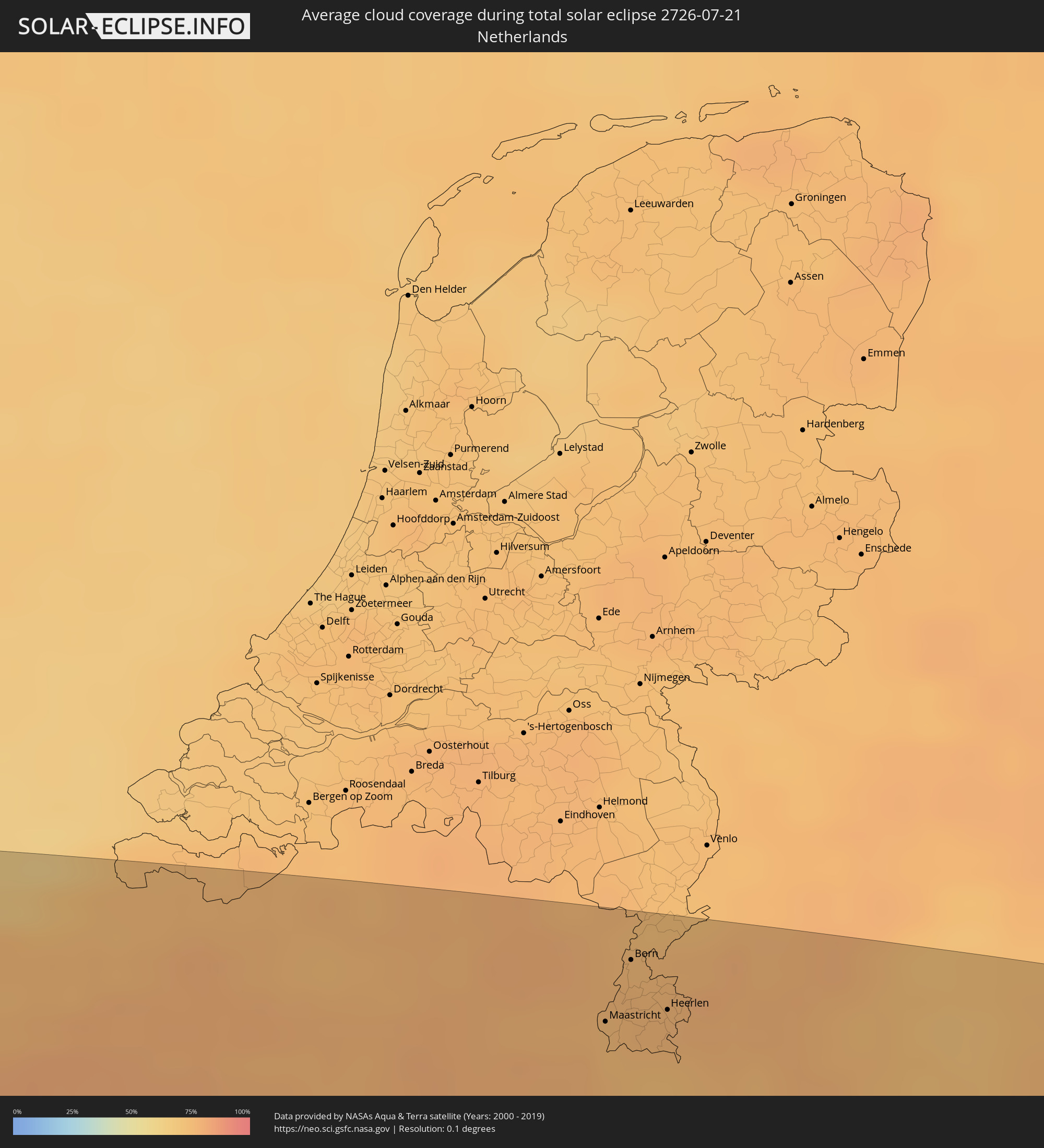 Niederlande
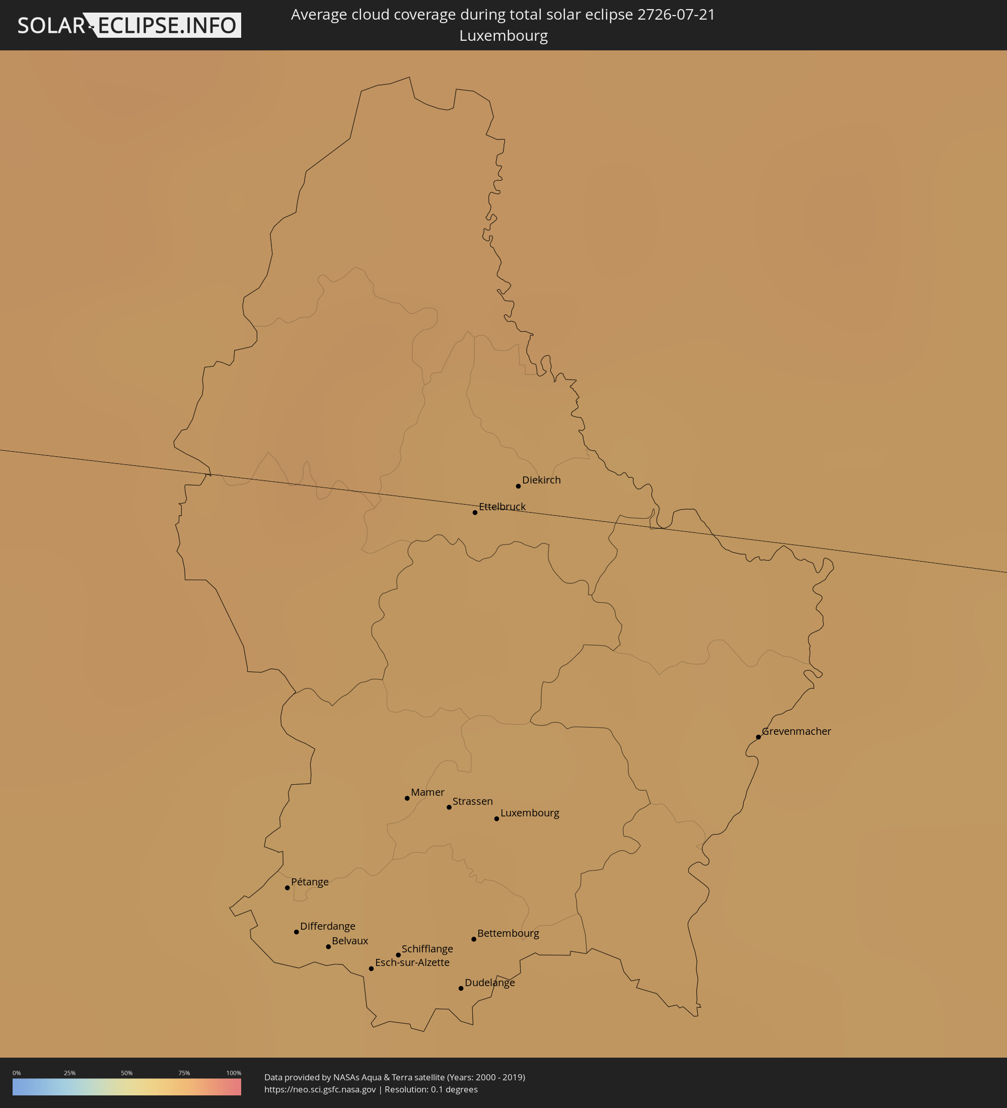 Luxemburg
 Deutschland
 Österreich
 Tschechien
 Polen
Polen
 Ungarn
 Slowakei
 Rumänien
 Ukraine
 Türkei
 Moldawien
 Georgien
 Armenien
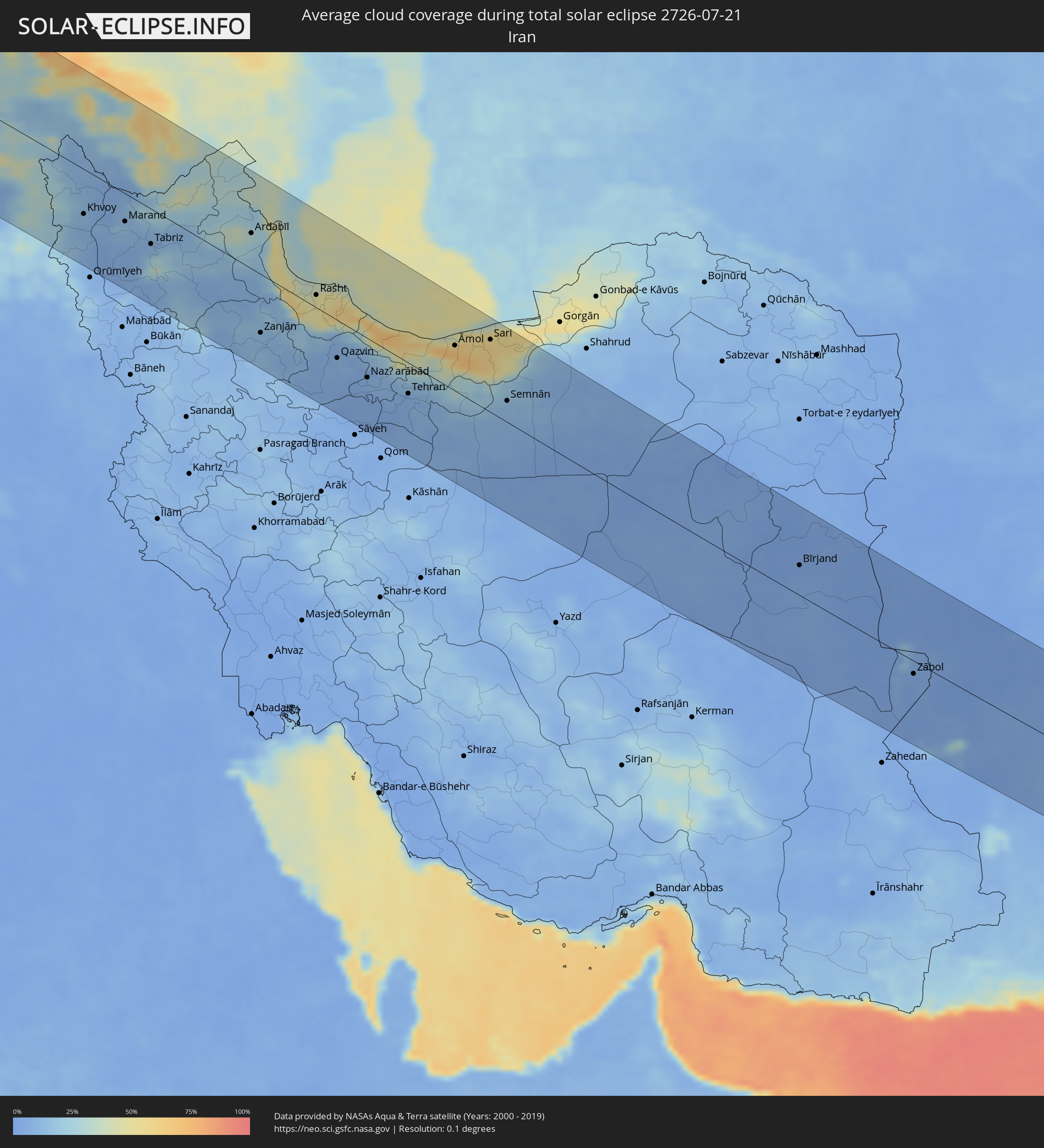 Iran
Iran
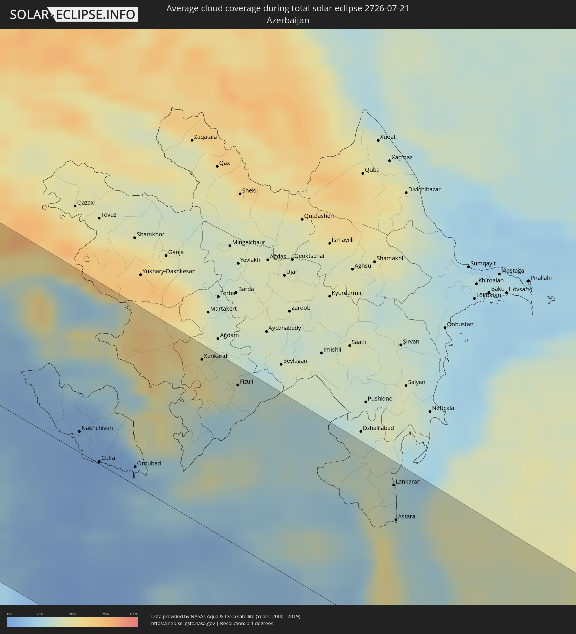 Aserbaidschan
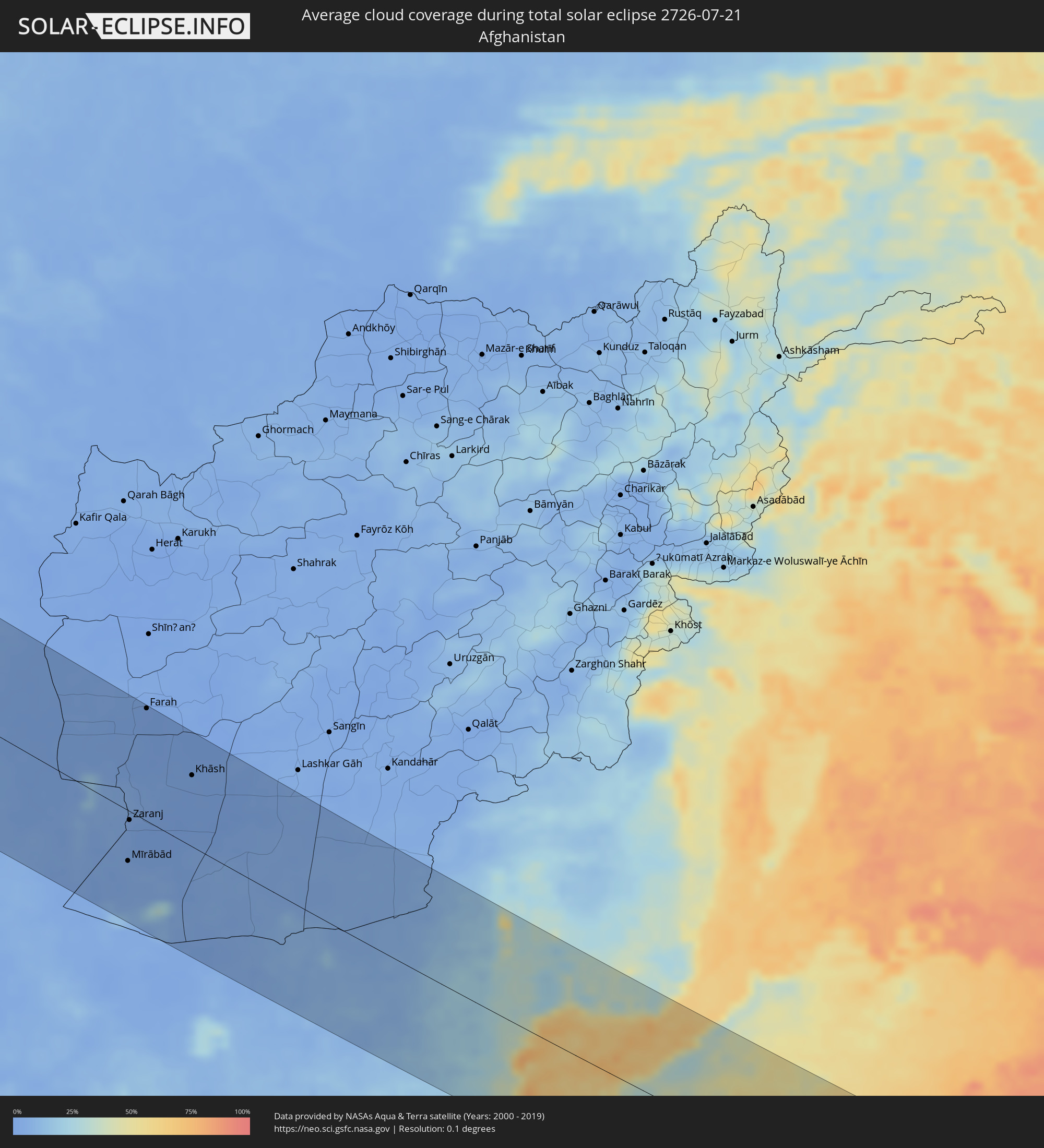 Afghanistan
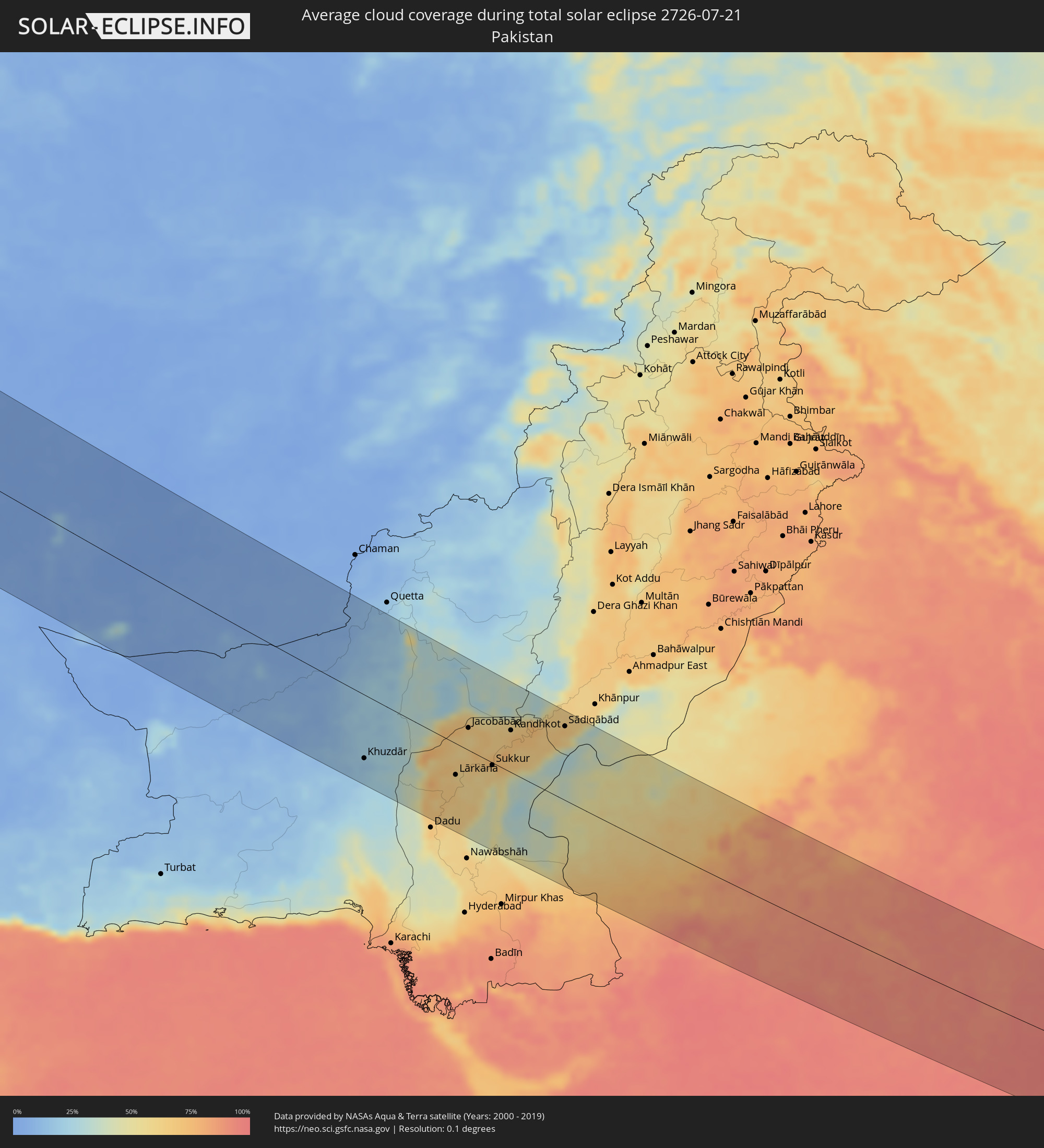 Pakistan
 Indien
Orte im Finsternispfad
Die nachfolgene Tabelle zeigt Städte und Orte mit mehr als 5.000 Einwohnern, die sich im Finsternispfad befinden. Städte mit mehr als 100.000 Einwohnern sind dick gekennzeichnet. Mit einem Klick auf den Ort öffnet sich eine Detailkarte die die Lage des jeweiligen Ortes zusammen mit dem Verlauf der zentralen Finsternis präsentiert.
| Ort | Typ | Dauer der Verfinsterung | Ortszeit bei maximaler Verfinsterung | Entfernung zur Zentrallinie | Ø Bewölkung |
|
Plymouth, England
|
total | - | 11:07:17 UTC+00:00 | 22 km | 75% |
|
Bristol, England
|
total | - | 11:09:59 UTC+00:00 | 142 km | 82% |
|
Saint Peter Port, St Peter Port
|
total | - | 11:09:24 UTC+00:00 | 80 km | 63% |
|
Saint Helier, St Helier
|
total | - | 11:10:00 UTC+00:00 | 111 km | 66% |
|
Le Hocq, St Clement
|
total | - | 11:10:03 UTC+00:00 | 113 km | 66% |
|
Bournemouth, England
|
total | - | 11:10:49 UTC+00:00 | 60 km | 71% |
|
Southampton, England
|
total | - | 11:11:35 UTC+00:00 | 81 km | 72% |
|
Portsmouth, England
|
total | - | 11:12:01 UTC+00:00 | 69 km | 70% |
|
Reading, England
|
total | - | 11:12:22 UTC+00:00 | 143 km | 81% |
|
Sutton, England
|
total | - | 11:13:30 UTC+00:00 | 132 km | 83% |
|
Brighton, England
|
total | - | 11:13:29 UTC+00:00 | 74 km | 69% |
|
Le Havre, Normandy
|
total | - | 12:13:35 UTC+01:00 | 73 km | 65% |
|
Bexley, England
|
total | - | 11:14:02 UTC+00:00 | 143 km | 81% |
|
Rouen, Normandy
|
total | - | 12:15:10 UTC+01:00 | 76 km | 76% |
|
Cergy-Pontoise, Île-de-France
|
total | - | 12:16:43 UTC+01:00 | 117 km | 75% |
|
Amiens, Hauts-de-France
|
total | - | 12:17:08 UTC+01:00 | 20 km | 82% |
|
Paris, Île-de-France
|
total | - | 12:17:09 UTC+01:00 | 136 km | 74% |
|
Lille, Hauts-de-France
|
total | - | 12:18:23 UTC+01:00 | 65 km | 81% |
|
Brugge, Flanders
|
total | - | 12:18:40 UTC+01:00 | 130 km | 75% |
|
Gent, Flanders
|
total | - | 12:19:25 UTC+01:00 | 115 km | 79% |
|
Mons, Wallonia
|
total | - | 12:19:46 UTC+01:00 | 50 km | 78% |
|
Reims, Grand-Est
|
total | - | 12:19:55 UTC+01:00 | 83 km | 77% |
|
Hulst, Zeeland
|
total | - | 12:19:56 UTC+01:00 | 143 km | 75% |
|
Brussels, Brussels Capital
|
total | - | 12:20:23 UTC+01:00 | 97 km | 78% |
|
Antwerpen, Flanders
|
total | - | 12:20:28 UTC+01:00 | 138 km | 75% |
|
Charleroi, Wallonia
|
total | - | 12:20:33 UTC+01:00 | 49 km | 78% |
|
Leuven, Flanders
|
total | - | 12:20:56 UTC+01:00 | 103 km | 78% |
|
Namur, Wallonia
|
total | - | 12:21:13 UTC+01:00 | 58 km | 78% |
|
Liège, Wallonia
|
total | - | 12:22:18 UTC+01:00 | 82 km | 76% |
|
Maastricht, Limburg
|
total | - | 12:22:28 UTC+01:00 | 107 km | 74% |
|
Heer, Limburg
|
total | - | 12:22:32 UTC+01:00 | 106 km | 74% |
|
Stein, Limburg
|
total | - | 12:22:35 UTC+01:00 | 121 km | 77% |
|
Elsloo, Limburg
|
total | - | 12:22:35 UTC+01:00 | 118 km | 76% |
|
Born, Limburg
|
total | - | 12:22:39 UTC+01:00 | 128 km | 77% |
|
Differdange, Luxembourg
|
total | - | 12:22:56 UTC+01:00 | 38 km | 74% |
|
Belvaux, Luxembourg
|
total | - | 12:23:00 UTC+01:00 | 39 km | 74% |
|
Esch-sur-Alzette, Luxembourg
|
total | - | 12:23:05 UTC+01:00 | 41 km | 74% |
|
Heerlen, Limburg
|
total | - | 12:22:55 UTC+01:00 | 113 km | 77% |
|
Simpelveld, Limburg
|
total | - | 12:22:56 UTC+01:00 | 107 km | 75% |
|
Vaals, Limburg
|
total | - | 12:23:00 UTC+01:00 | 101 km | 75% |
|
Mamer, Luxembourg
|
total | - | 12:23:08 UTC+01:00 | 26 km | 72% |
|
Bertrange, Luxembourg
|
total | - | 12:23:11 UTC+01:00 | 27 km | 74% |
|
Strassen, Luxembourg
|
total | - | 12:23:13 UTC+01:00 | 26 km | 74% |
|
Ettelbruck, Diekirch
|
total | - | 12:23:14 UTC+01:00 | 1 km | 72% |
|
Luxembourg, Luxembourg
|
total | - | 12:23:19 UTC+01:00 | 26 km | 74% |
|
Diekirch, Diekirch
|
total | - | 12:23:19 UTC+01:00 | 2 km | 73% |
|
Metz, Grand-Est
|
total | - | 12:23:27 UTC+01:00 | 81 km | 73% |
|
Köln, North Rhine-Westphalia
|
total | - | 12:24:25 UTC+01:00 | 127 km | 75% |
|
Bonn, North Rhine-Westphalia
|
total | - | 12:24:41 UTC+01:00 | 106 km | 73% |
|
Strasbourg, Grand-Est
|
total | - | 12:26:10 UTC+01:00 | 124 km | 62% |
|
Wiesbaden, Hesse
|
total | - | 12:26:38 UTC+01:00 | 46 km | 72% |
|
Karlsruhe, Baden-Württemberg
|
total | - | 12:27:10 UTC+01:00 | 70 km | 63% |
|
Mannheim, Baden-Württemberg
|
total | - | 12:27:09 UTC+01:00 | 16 km | 69% |
|
Frankfurt am Main, Hesse
|
total | - | 12:27:19 UTC+01:00 | 54 km | 71% |
|
Stuttgart, Baden-Württemberg
|
total | - | 12:28:31 UTC+01:00 | 86 km | 70% |
|
Nürnberg, Bavaria
|
total | - | 12:31:23 UTC+01:00 | 12 km | 71% |
|
Munich, Bavaria
|
total | - | 12:32:46 UTC+01:00 | 125 km | 57% |
|
Karlovy Vary, Karlovarský
|
total | - | 12:33:54 UTC+01:00 | 122 km | 72% |
|
Salzburg, Salzburg
|
total | - | 12:35:25 UTC+01:00 | 139 km | 54% |
|
Pilsen, Plzeňský
|
total | - | 12:34:56 UTC+01:00 | 78 km | 67% |
|
Wels, Upper Austria
|
total | - | 12:36:52 UTC+01:00 | 83 km | 59% |
|
Kladno, Central Bohemia
|
total | - | 12:35:52 UTC+01:00 | 133 km | 70% |
|
Linz, Upper Austria
|
total | - | 12:37:12 UTC+01:00 | 64 km | 57% |
|
Prague, Praha
|
total | - | 12:36:23 UTC+01:00 | 131 km | 72% |
|
Steyr, Upper Austria
|
total | - | 12:37:35 UTC+01:00 | 90 km | 54% |
|
České Budějovice, Jihočeský
|
total | - | 12:37:07 UTC+01:00 | 12 km | 64% |
|
Jihlava, Vysočina
|
total | - | 12:38:38 UTC+01:00 | 77 km | 70% |
|
Weinzierl bei Krems, Lower Austria
|
total | - | 12:39:17 UTC+01:00 | 30 km | 61% |
|
Sankt Pölten, Lower Austria
|
total | - | 12:39:29 UTC+01:00 | 51 km | 56% |
|
Baden, Lower Austria
|
total | - | 12:40:35 UTC+01:00 | 61 km | 59% |
|
Wiener Neustadt, Lower Austria
|
total | - | 12:40:45 UTC+01:00 | 82 km | 58% |
|
Vienna, Vienna
|
total | - | 12:40:40 UTC+01:00 | 36 km | 61% |
|
Brno, South Moravian
|
total | - | 12:40:22 UTC+01:00 | 75 km | 68% |
|
Szombathely, Vas
|
total | - | 12:41:47 UTC+01:00 | 136 km | 52% |
|
Bratislava, Bratislavský
|
total | - | 12:41:54 UTC+01:00 | 28 km | 57% |
|
Olomouc, Olomoucký
|
total | - | 12:41:06 UTC+01:00 | 130 km | 72% |
|
Trnava, Trnavský
|
total | - | 12:42:30 UTC+01:00 | 6 km | 61% |
|
Győr, Győr-Moson-Sopron
|
total | - | 12:43:07 UTC+01:00 | 67 km | 57% |
|
Zlín, Zlín
|
total | - | 12:42:00 UTC+01:00 | 99 km | 67% |
|
Trenčín, Trenčiansky
|
total | - | 12:42:50 UTC+01:00 | 71 km | 66% |
|
Nitra, Nitriansky
|
total | - | 12:43:21 UTC+01:00 | 9 km | 62% |
|
Székesfehérvár, Fejér
|
total | - | 12:44:46 UTC+01:00 | 103 km | 53% |
|
Žilina, Žilinský
|
total | - | 12:43:40 UTC+01:00 | 120 km | 69% |
|
Martin, Žilinský
|
total | - | 12:44:04 UTC+01:00 | 108 km | 69% |
|
Budapest, Budapest
|
total | - | 12:45:32 UTC+01:00 | 57 km | 56% |
|
Banská Bystrica, Banskobystrický
|
total | - | 12:44:41 UTC+01:00 | 78 km | 63% |
|
Budapest XVII. kerület, Budapest
|
total | - | 12:45:53 UTC+01:00 | 54 km | 58% |
|
Kecskemét, Bács-Kiskun
|
total | - | 12:47:05 UTC+01:00 | 105 km | 50% |
|
Poprad, Prešovský
|
total | - | 12:46:10 UTC+01:00 | 137 km | 75% |
|
Miskolc, Borsod-Abaúj-Zemplén
|
total | - | 12:47:46 UTC+01:00 | 47 km | 62% |
|
Košice, Košický
|
total | - | 12:47:56 UTC+01:00 | 123 km | 65% |
|
Debrecen, Hajdú-Bihar
|
total | - | 12:49:36 UTC+01:00 | 8 km | 54% |
|
Nyíregyháza, Szabolcs-Szatmár-Bereg
|
total | - | 12:49:20 UTC+01:00 | 54 km | 53% |
|
Oradea, Bihor
|
total | - | 13:50:31 UTC+02:00 | 37 km | 48% |
|
Uzhhorod, Zakarpattia
|
total | - | 13:49:35 UTC+02:00 | 138 km | 57% |
|
Mukacheve, Zakarpattia
|
total | - | 13:50:23 UTC+02:00 | 130 km | 55% |
|
Cluj-Napoca, Cluj
|
total | - | 13:53:24 UTC+02:00 | 22 km | 55% |
|
Braşov, Braşov
|
total | - | 13:57:41 UTC+02:00 | 83 km | 63% |
|
Ploieşti, Prahova
|
total | - | 13:59:07 UTC+02:00 | 143 km | 42% |
|
Bacău, Bacău
|
total | - | 13:58:35 UTC+02:00 | 50 km | 37% |
|
Iaşi, Iaşi
|
total | - | 13:58:52 UTC+02:00 | 132 km | 44% |
|
Ungheni, Ungheni
|
total | - | 13:59:05 UTC+02:00 | 142 km | 43% |
|
Brăila, Brăila
|
total | - | 14:01:42 UTC+02:00 | 51 km | 33% |
|
Galaţi, Galaţi
|
total | - | 14:01:34 UTC+02:00 | 30 km | 33% |
|
Cahul, Cahul
|
total | - | 14:01:14 UTC+02:00 | 21 km | 36% |
|
Leova, Leova
|
total | - | 14:00:36 UTC+02:00 | 82 km | 42% |
|
Vulcăneşti, Găgăuzia
|
total | - | 14:01:48 UTC+02:00 | 5 km | 38% |
|
Hînceşti, Hînceşti
|
total | - | 14:00:39 UTC+02:00 | 127 km | 45% |
|
Constanţa, Constanța
|
total | - | 14:04:00 UTC+02:00 | 141 km | 29% |
|
Comrat, Găgăuzia
|
total | - | 14:01:24 UTC+02:00 | 75 km | 42% |
|
Ialoveni, Laloveni
|
total | - | 14:00:47 UTC+02:00 | 145 km | 43% |
|
Ceadîr-Lunga, Găgăuzia
|
total | - | 14:01:56 UTC+02:00 | 57 km | 43% |
|
Izmayil, Odessa
|
total | - | 14:02:50 UTC+02:00 | 16 km | 27% |
|
Căuşeni, Căuşeni
|
total | - | 14:02:02 UTC+02:00 | 133 km | 42% |
|
Bilhorod-Dnistrovs’kyy, Odessa
|
total | - | 14:03:53 UTC+02:00 | 118 km | 36% |
|
Illichivs’k, Odessa
|
total | - | 14:04:09 UTC+02:00 | 139 km | 31% |
|
Yevpatoriya, Republic of Crimea
|
total | - | 15:09:12 UTC+03:00 | 120 km | 33% |
|
Sevastopol, Gorod Sevastopol
|
total | - | 15:10:15 UTC+03:00 | 65 km | 22% |
|
Simferopol, Republic of Crimea
|
total | - | 15:10:30 UTC+03:00 | 122 km | 42% |
|
Yalta, Republic of Crimea
|
total | - | 15:11:12 UTC+03:00 | 79 km | 36% |
|
Ordu, Ordu
|
total | - | 15:20:57 UTC+03:00 | 127 km | 67% |
|
Giresun, Giresun
|
total | - | 15:21:38 UTC+03:00 | 114 km | 79% |
|
Trabzon, Trabzon
|
total | - | 15:23:03 UTC+03:00 | 51 km | 80% |
|
Rize, Rize
|
total | - | 15:23:55 UTC+03:00 | 17 km | 87% |
|
Erzurum, Erzurum
|
total | - | 15:26:26 UTC+03:00 | 93 km | 32% |
|
Batumi, Ajaria
|
total | - | 16:24:10 UTC+04:00 | 89 km | 76% |
|
P’ot’i, Samegrelo and Zemo Svaneti
|
total | - | 16:23:27 UTC+04:00 | 139 km | 59% |
|
Chakvi, Ajaria
|
total | - | 16:24:09 UTC+04:00 | 101 km | 78% |
|
Kobuleti, Ajaria
|
total | - | 16:24:03 UTC+04:00 | 112 km | 81% |
|
Ozurgeti, Guria
|
total | - | 16:24:08 UTC+04:00 | 132 km | 84% |
|
Dioknisi, Ajaria
|
total | - | 16:24:59 UTC+04:00 | 120 km | 61% |
|
Patnos, Ağrı
|
total | - | 15:29:09 UTC+03:00 | 93 km | 23% |
|
Akhaltsikhe, Samtskhe-Javakheti
|
total | - | 16:25:34 UTC+04:00 | 145 km | 52% |
|
Ağrı, Ağrı
|
total | - | 15:28:35 UTC+03:00 | 37 km | 22% |
|
Erciş, Van
|
total | - | 15:29:58 UTC+03:00 | 90 km | 9% |
|
Van, Van
|
total | - | 15:30:49 UTC+03:00 | 140 km | 13% |
|
Akhalk’alak’i
|
total | - | 16:26:26 UTC+04:00 | 144 km | 40% |
|
Ninotsminda, Samtskhe-Javakheti
|
total | - | 16:26:45 UTC+04:00 | 135 km | 46% |
|
Gyumri, Shirak Province
|
total | - | 16:27:44 UTC+04:00 | 101 km | 26% |
|
Armavir, Armavir Province
|
total | - | 16:28:54 UTC+04:00 | 48 km | 13% |
|
Ejmiatsin, Armavir Province
|
total | - | 16:29:08 UTC+04:00 | 60 km | 15% |
|
Step’anavan, Lori Province
|
total | - | 16:27:55 UTC+04:00 | 145 km | 69% |
|
Vanadzor, Lori Province
|
total | - | 16:28:21 UTC+04:00 | 130 km | 68% |
|
Yerevan, Yerevan
|
total | - | 16:29:20 UTC+04:00 | 71 km | 17% |
|
Ararat, Ararat Province
|
total | - | 16:30:03 UTC+04:00 | 45 km | 13% |
|
Hrazdan, Kotayk Province
|
total | - | 16:29:05 UTC+04:00 | 112 km | 37% |
|
Nakhchivan, Nakhichevan
|
total | - | 16:31:41 UTC+04:00 | 17 km | 10% |
|
Culfa, Nakhichevan
|
total | - | 16:32:16 UTC+04:00 | 2 km | 7% |
|
Ordubad, Nakhichevan
|
total | - | 16:32:42 UTC+04:00 | 15 km | 12% |
|
Kerbakhiar, Kalbajar
|
total | - | 16:30:52 UTC+04:00 | 131 km | 64% |
|
Tabriz, East Azerbaijan
|
total | - | 16:04:14 UTC+03:30 | 53 km | 10% |
|
Qafan, Syunik Province
|
total | - | 16:32:35 UTC+04:00 | 60 km | 46% |
|
Xankandi, Xankǝndi
|
total | - | 16:31:57 UTC+04:00 | 134 km | 46% |
|
Fizuli, Füzuli
|
total | - | 16:32:38 UTC+04:00 | 131 km | 40% |
|
Ardabīl, Ardabīl
|
total | - | 16:05:41 UTC+03:30 | 53 km | 24% |
|
Zanjān, Zanjan
|
total | - | 16:08:16 UTC+03:30 | 89 km | 13% |
|
Masally, Masally
|
total | - | 16:34:47 UTC+04:00 | 145 km | 39% |
|
Lankaran, Lənkəran
|
total | - | 16:35:22 UTC+04:00 | 126 km | 30% |
|
Astara, Astara
|
total | - | 16:35:51 UTC+04:00 | 99 km | 33% |
|
Rasht, Gīlān
|
total | - | 16:08:14 UTC+03:30 | 19 km | 49% |
|
Qazvin, Qazvīn
|
total | - | 16:10:05 UTC+03:30 | 58 km | 10% |
|
Karaj, Alborz
|
total | - | 16:11:29 UTC+03:30 | 54 km | 9% |
|
Tehran, Tehrān
|
total | - | 16:12:00 UTC+03:30 | 47 km | 7% |
|
Qarchak, Tehrān
|
total | - | 16:12:30 UTC+03:30 | 66 km | 9% |
|
Sari, Māzandarān
|
total | - | 16:11:48 UTC+03:30 | 112 km | 58% |
|
Mīrābād, Nimroz
|
total | - | 17:24:52 UTC+04:30 | 63 km | 3% |
|
Zaranj, Nimroz
|
total | - | 17:24:10 UTC+04:30 | 11 km | 3% |
|
Farah, Farah
|
total | - | 17:22:18 UTC+04:30 | 138 km | 1% |
|
Rūdbār, Nimroz
|
total | - | 17:25:29 UTC+04:30 | 55 km | 2% |
|
Khāsh, Nimroz
|
total | - | 17:23:41 UTC+04:30 | 88 km | 2% |
|
‘Alāqahdārī Dīshū, Helmand
|
total | - | 17:25:18 UTC+04:30 | 6 km | 4% |
|
Markaz-e Ḩukūmat-e Darwēshān, Helmand
|
total | - | 17:24:36 UTC+04:30 | 116 km | 2% |
|
Khuzdār, Balochistān
|
total | - | 17:59:22 UTC+05:00 | 96 km | 17% |
|
Kambar, Sindh
|
total | - | 17:59:50 UTC+05:00 | 55 km | 64% |
|
Lārkāna, Sindh
|
total | - | 17:59:53 UTC+05:00 | 48 km | 62% |
|
Jacobābād, Sindh
|
total | - | 17:59:01 UTC+05:00 | 34 km | 65% |
|
Shikārpur, Sindh
|
total | - | 17:59:26 UTC+05:00 | 11 km | 72% |
|
Khairpur, Sindh
|
total | - | 17:59:58 UTC+05:00 | 25 km | 60% |
|
Sukkur, Sindh
|
total | - | 17:59:46 UTC+05:00 | 4 km | 62% |
|
Kandhkot, Sindh
|
total | - | 17:59:08 UTC+05:00 | 64 km | 68% |
|
Sādiqābād, Punjab
|
total | - | 17:59:07 UTC+05:00 | 113 km | 69% |
|
Jodhpur, Rajasthan
|
total | - | 18:31:33 UTC+05:30 | 40 km | 81% |
|
Udaipur, Rajasthan
|
total | - | 18:33:24 UTC+05:30 | 100 km | 89% |
|
Ajmer, Rajasthan
|
total | - | 18:31:15 UTC+05:30 | 130 km | 84% |
|
Kota, Rajasthan
|
total | - | 18:32:32 UTC+05:30 | 55 km | 87% |
|
Bhopal, Madhya Pradesh
|
total | - | 18:34:19 UTC+05:30 | 73 km | 92% |
|
Jabalpur, Madhya Pradesh
|
total | - | 18:33:54 UTC+05:30 | 24 km | 95% |
|
Bhilai, Chhattisgarh
|
total | - | 18:35:23 UTC+05:30 | 117 km | 97% |
|
Raipur, Chhattisgarh
|
total | - | 18:35:18 UTC+05:30 | 106 km | 98% |
|
Korba, Chhattisgarh
|
total | - | 18:33:57 UTC+05:30 | 51 km | 98% |