Total solar eclipse of 07/21/2726
| Day of week: | Wednesday |
| Maximum duration of eclipse: | 05m43s |
| Maximum width of eclipse path: | 288 km |
| Saros cycle: | 167 |
| Coverage: | 100% |
| Magnitude: | 1.078 |
| Gamma: | 0.4807 |
Wo kann man die Sonnenfinsternis vom 07/21/2726 sehen?
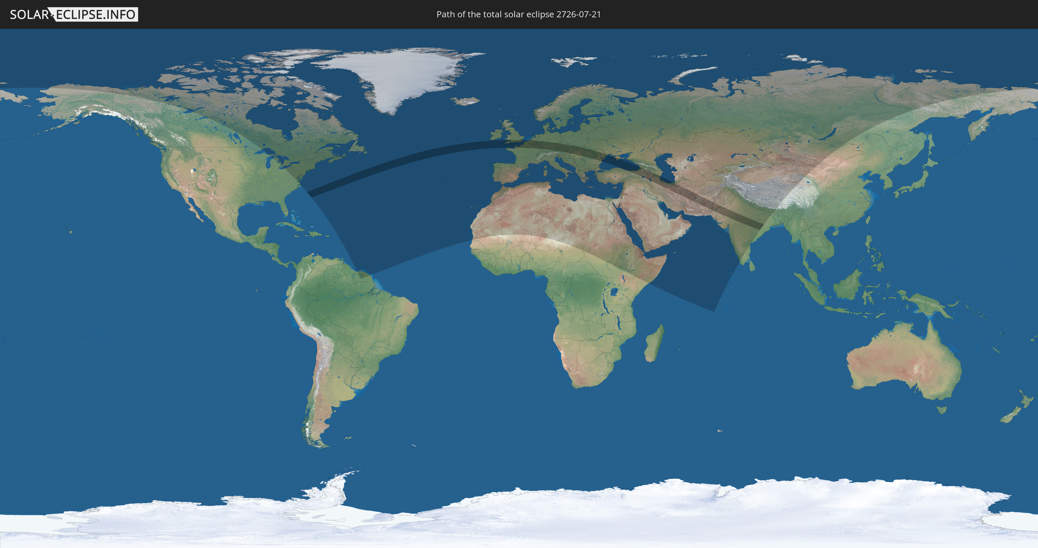
Die Sonnenfinsternis am 07/21/2726 kann man in 108 Ländern als partielle Sonnenfinsternis beobachten.
Der Finsternispfad verläuft durch 24 Länder. Nur in diesen Ländern ist sie als total Sonnenfinsternis zu sehen.
In den folgenden Ländern ist die Sonnenfinsternis total zu sehen
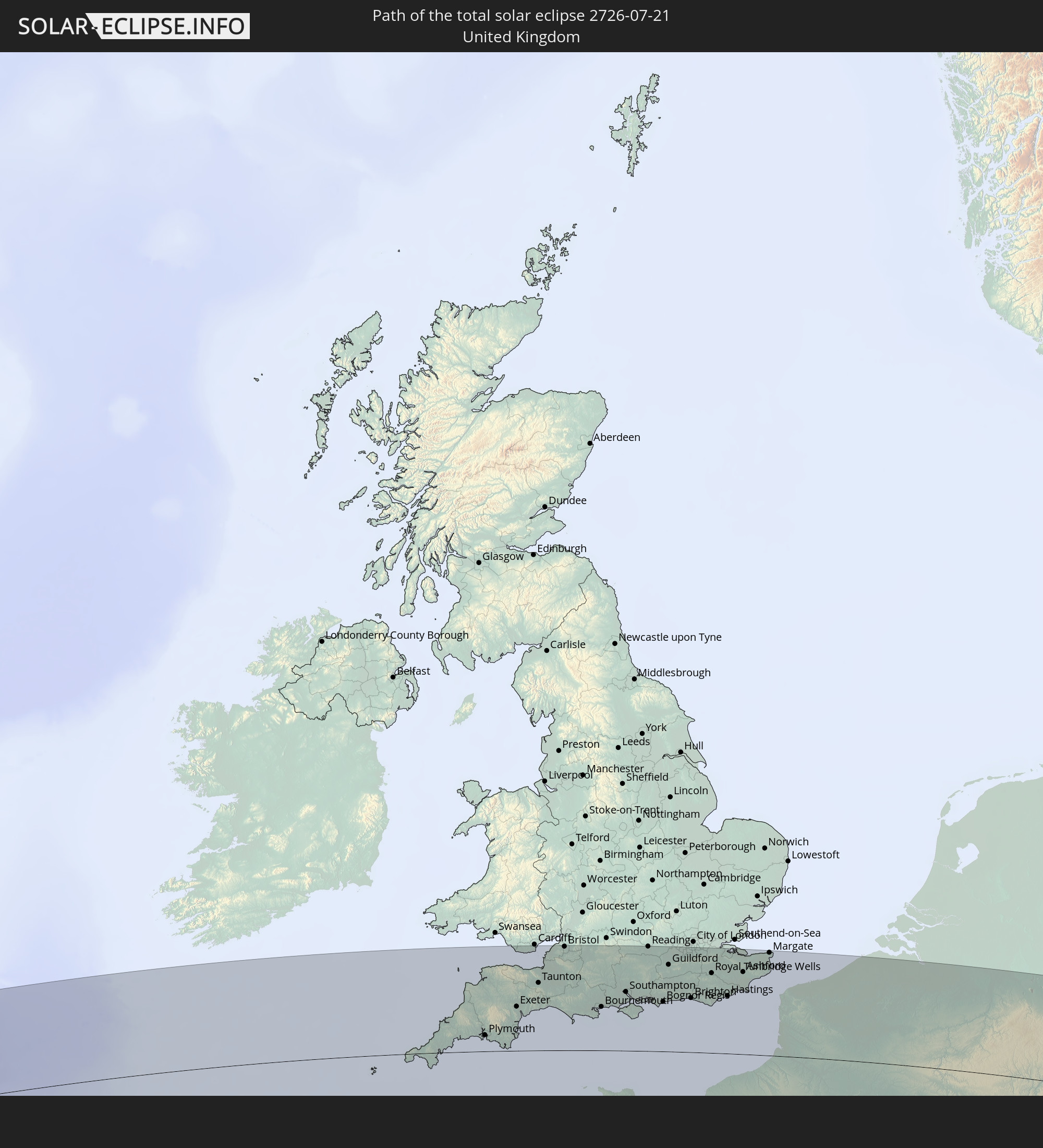 United Kingdom
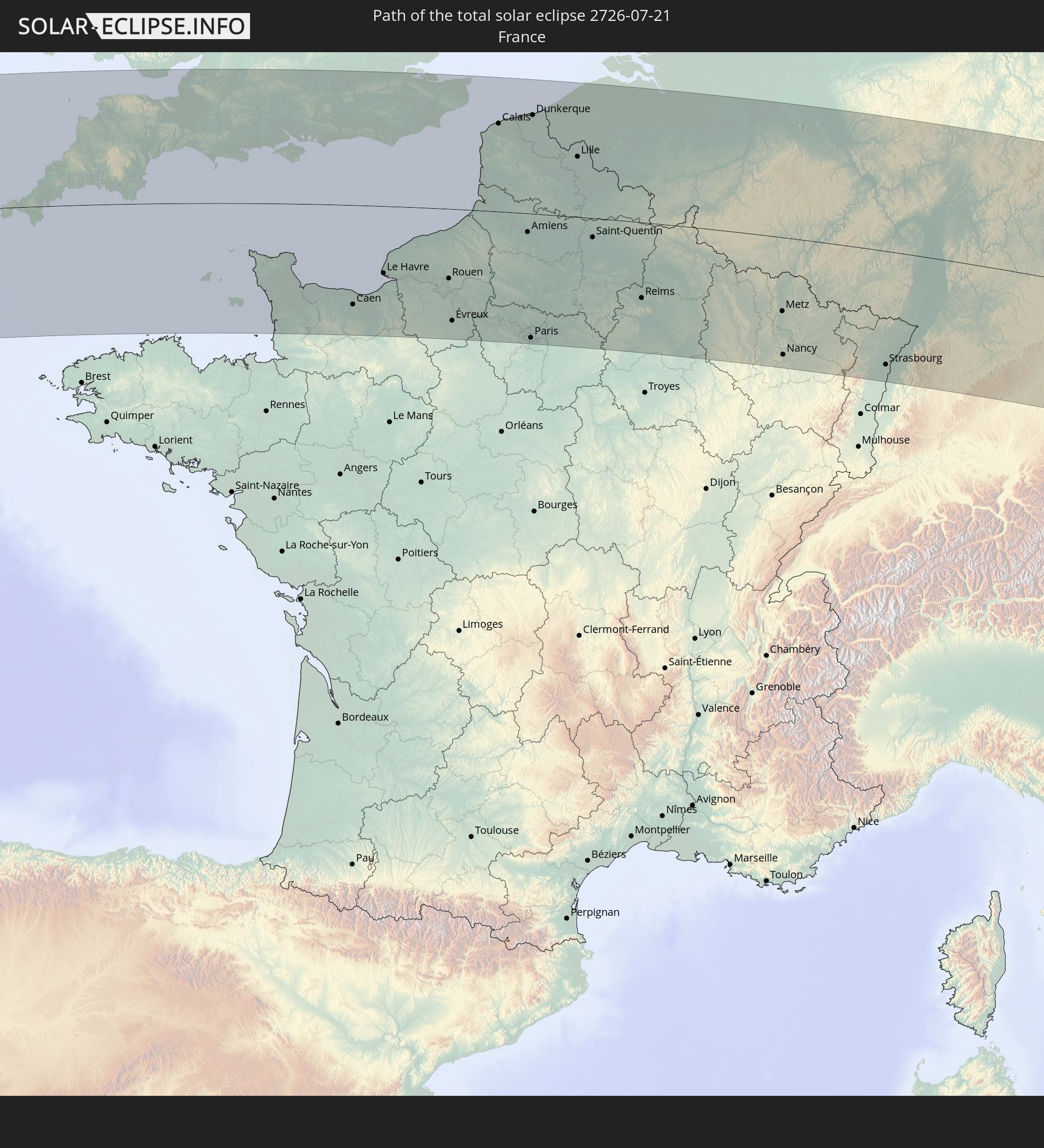 France
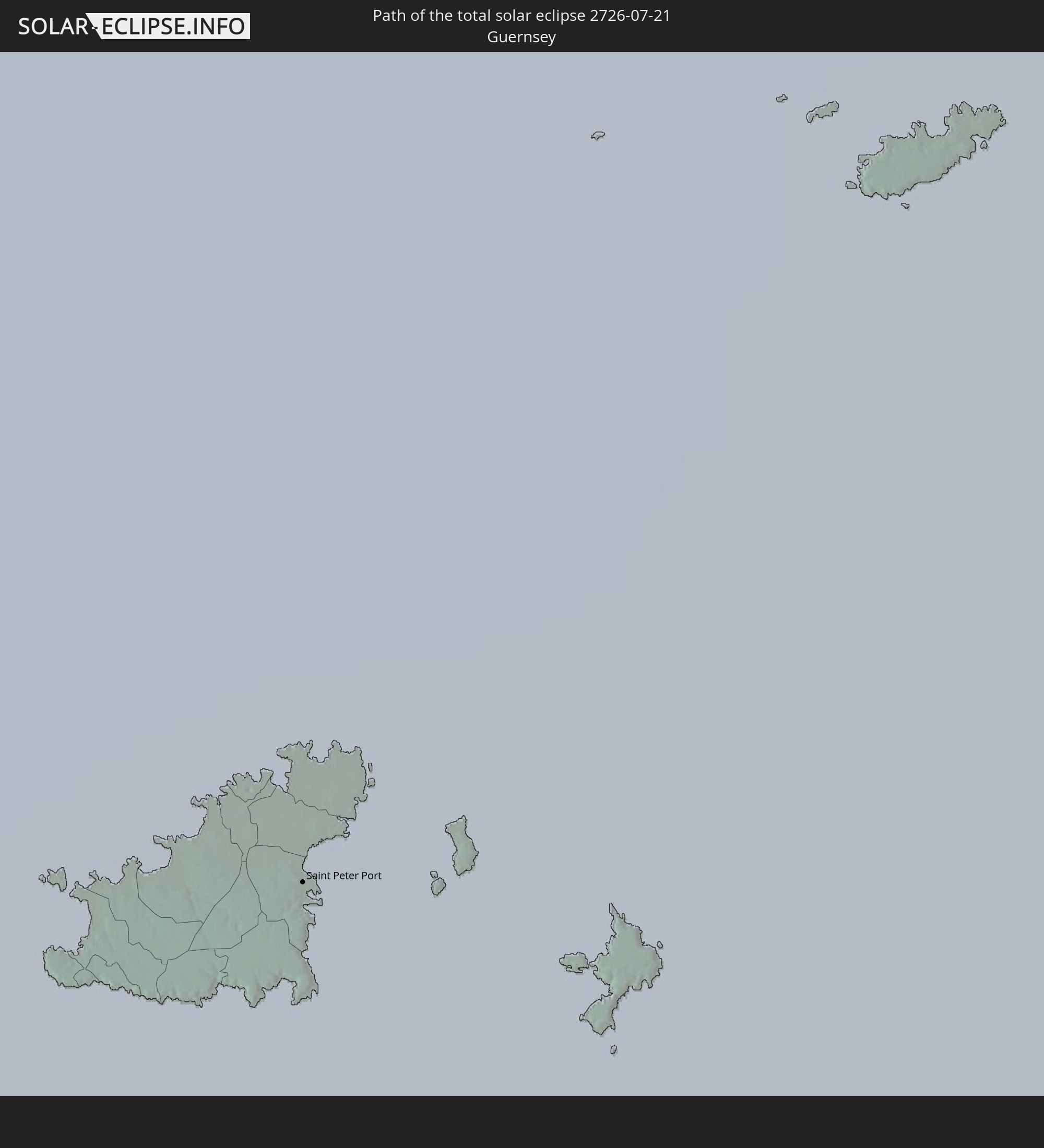 Guernsey
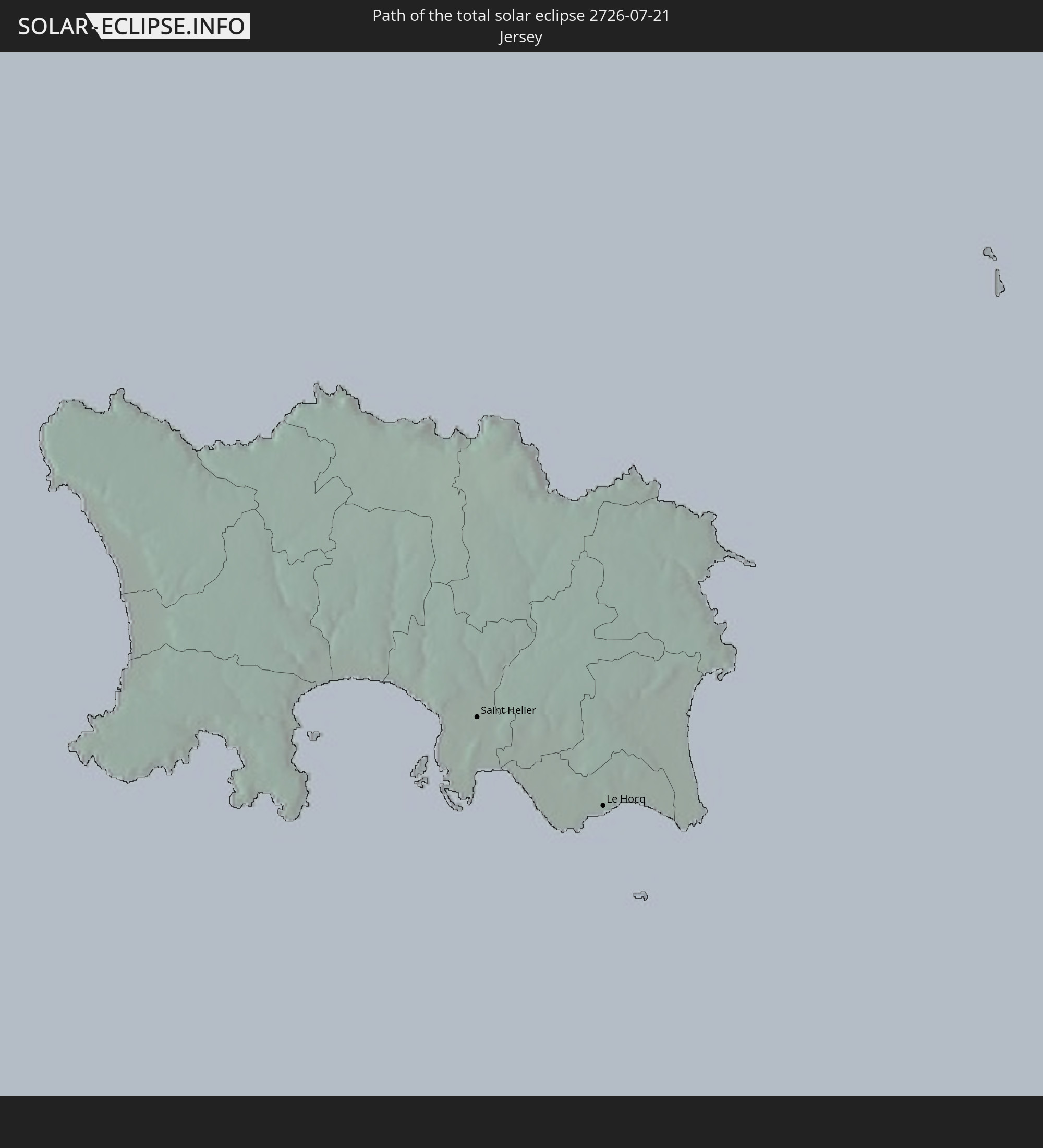 Jersey
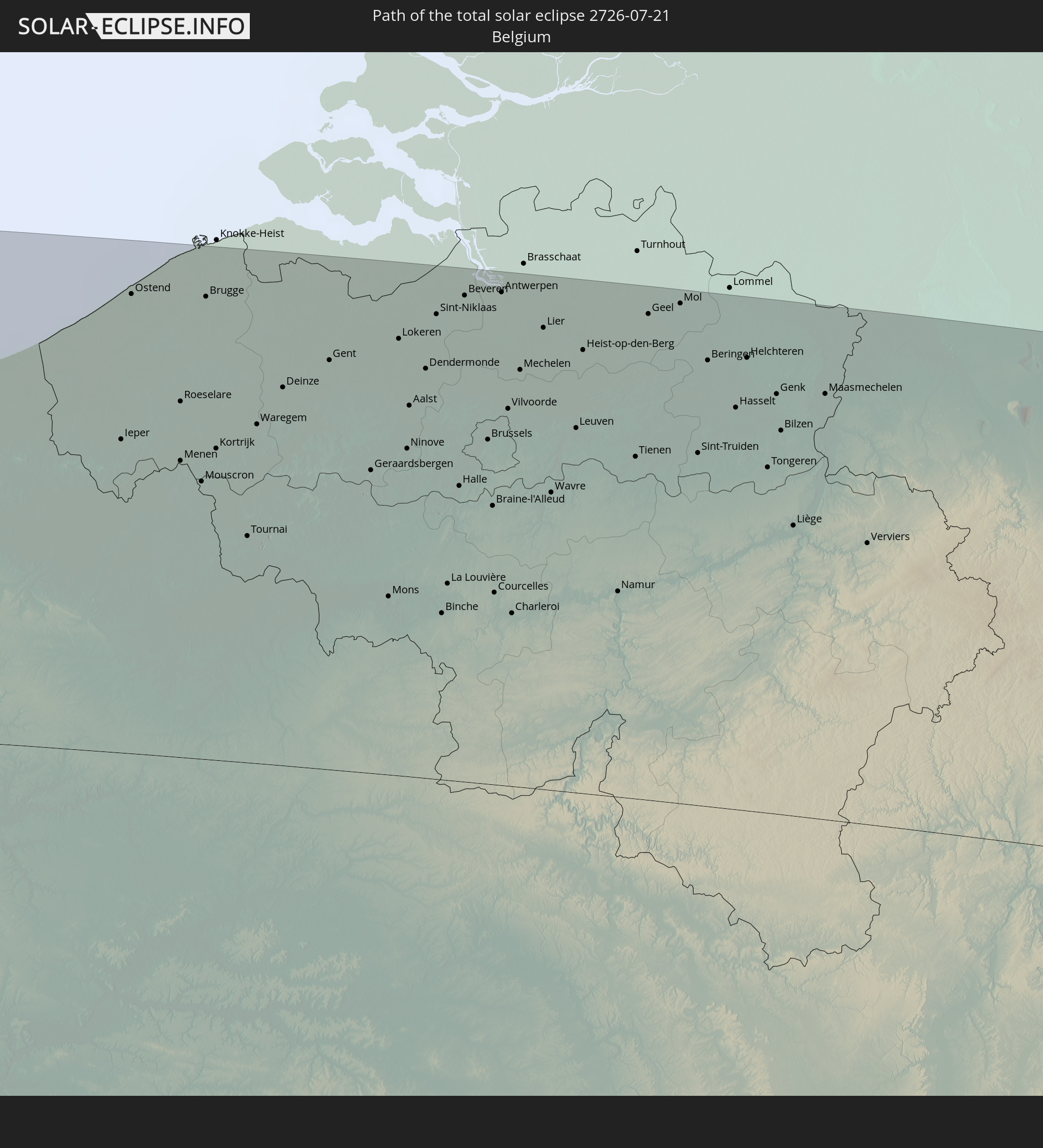 Belgium
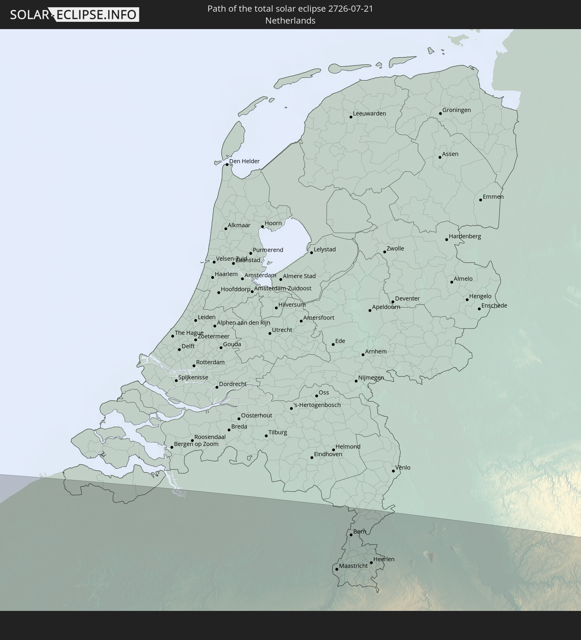 Netherlands
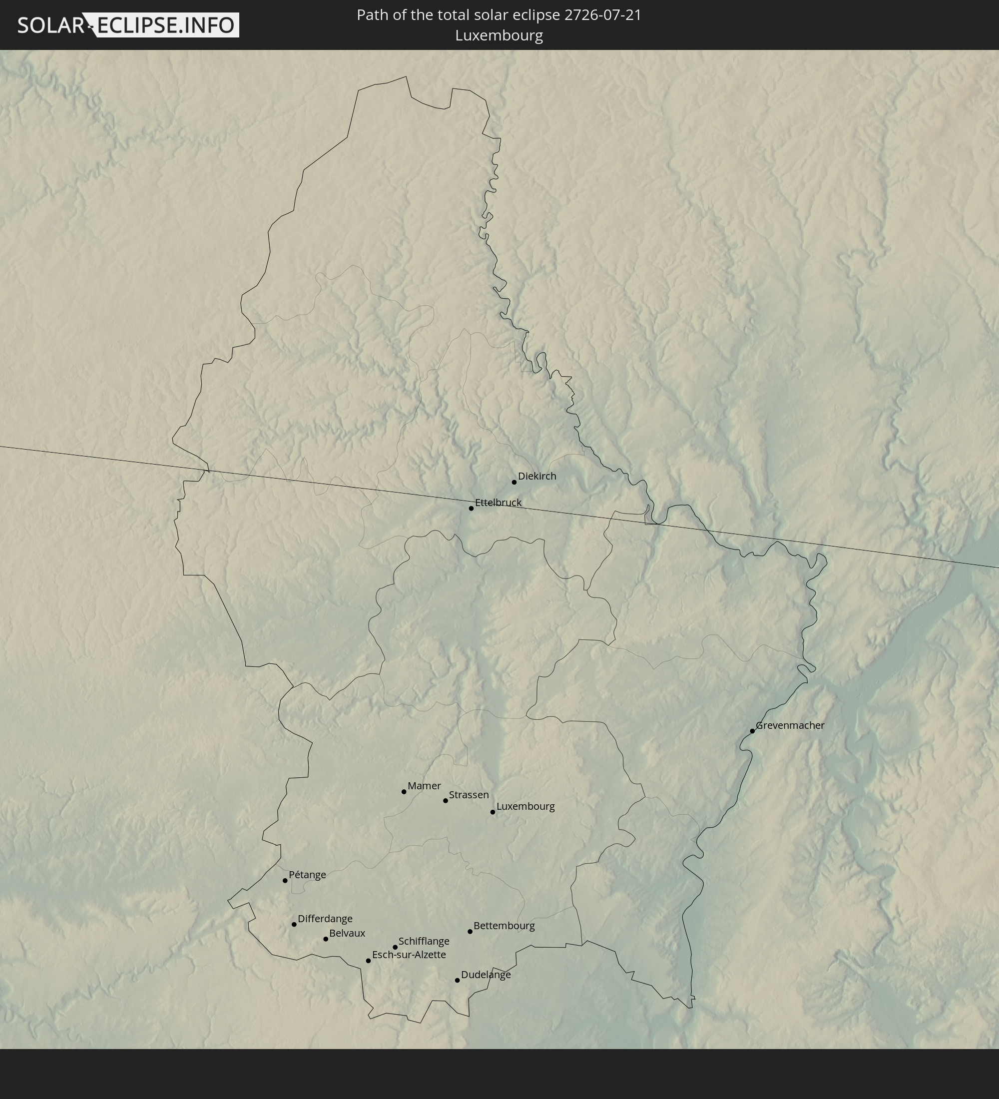 Luxembourg
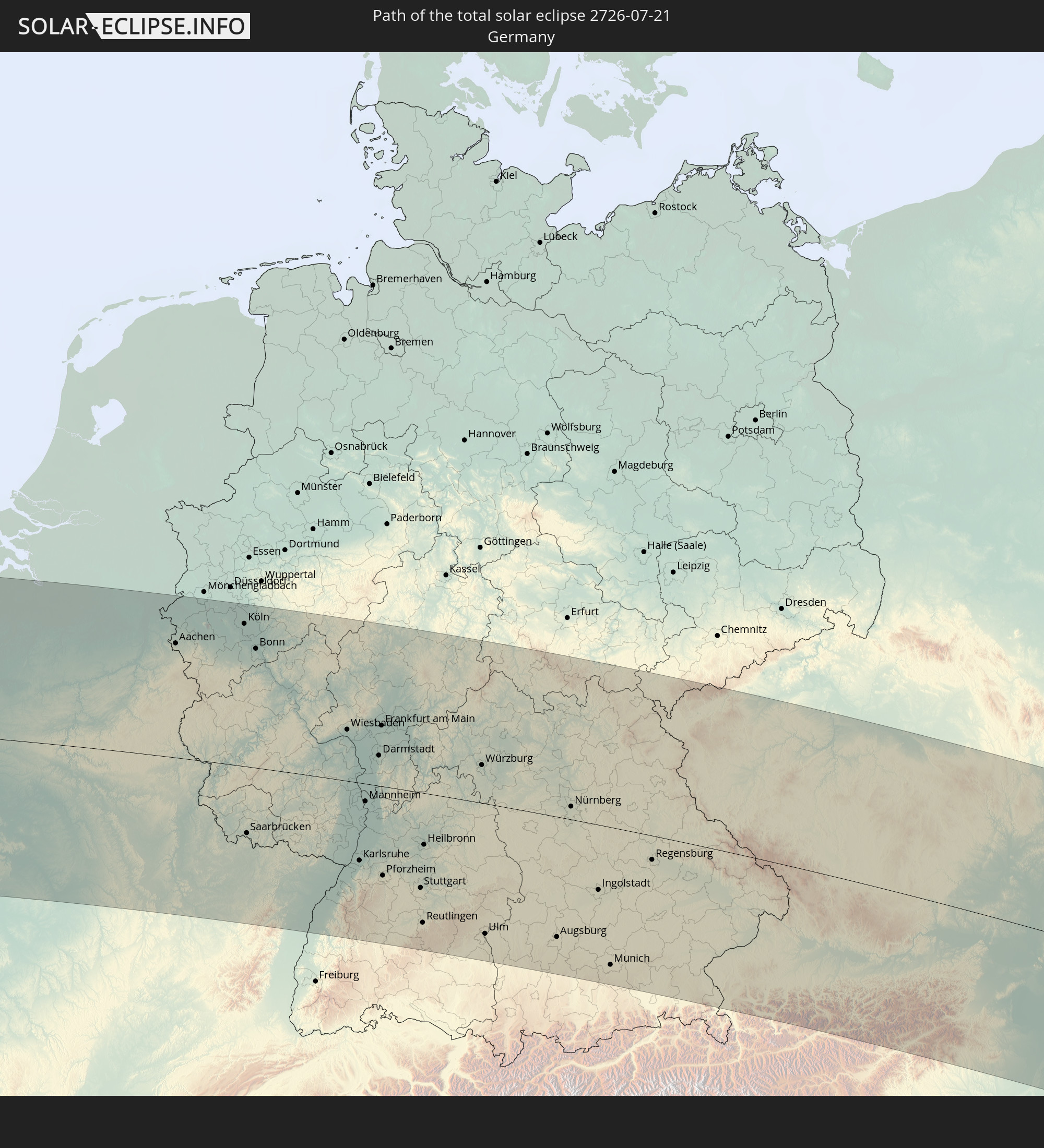 Germany
 Austria
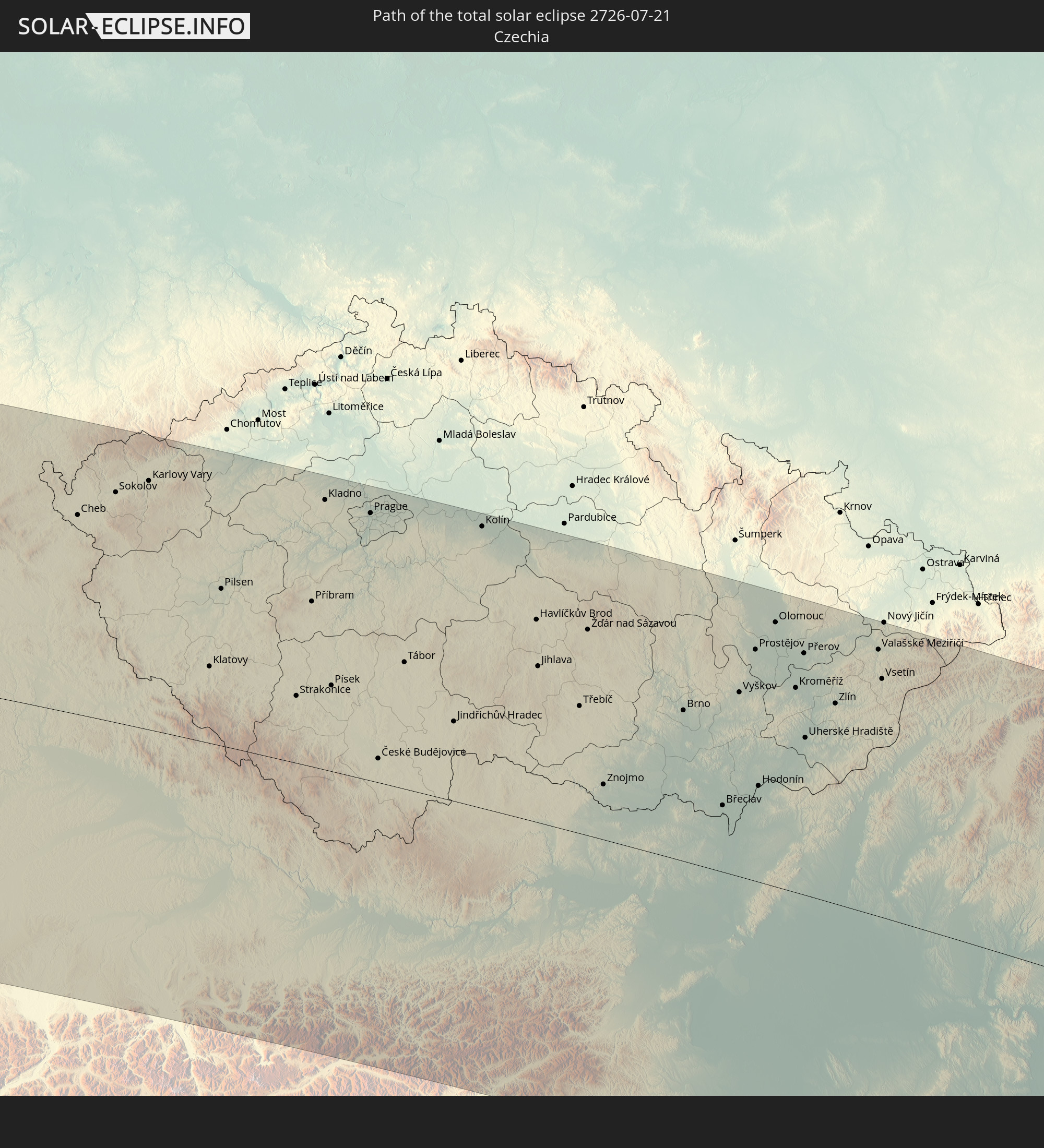 Czechia
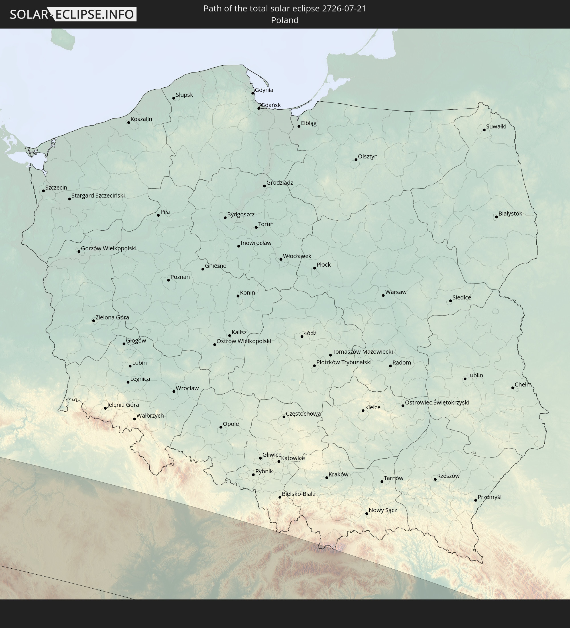 Poland
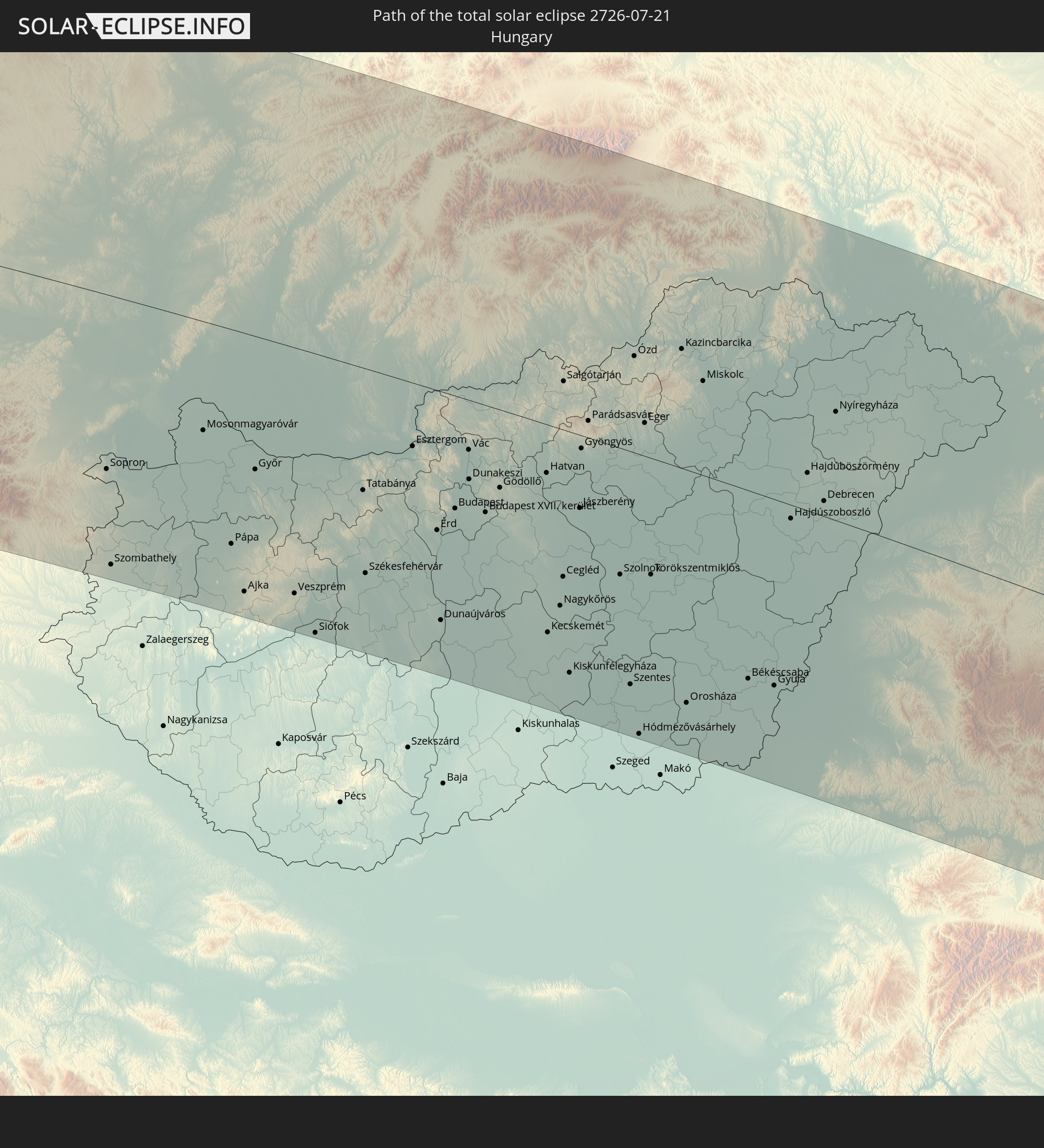 Hungary
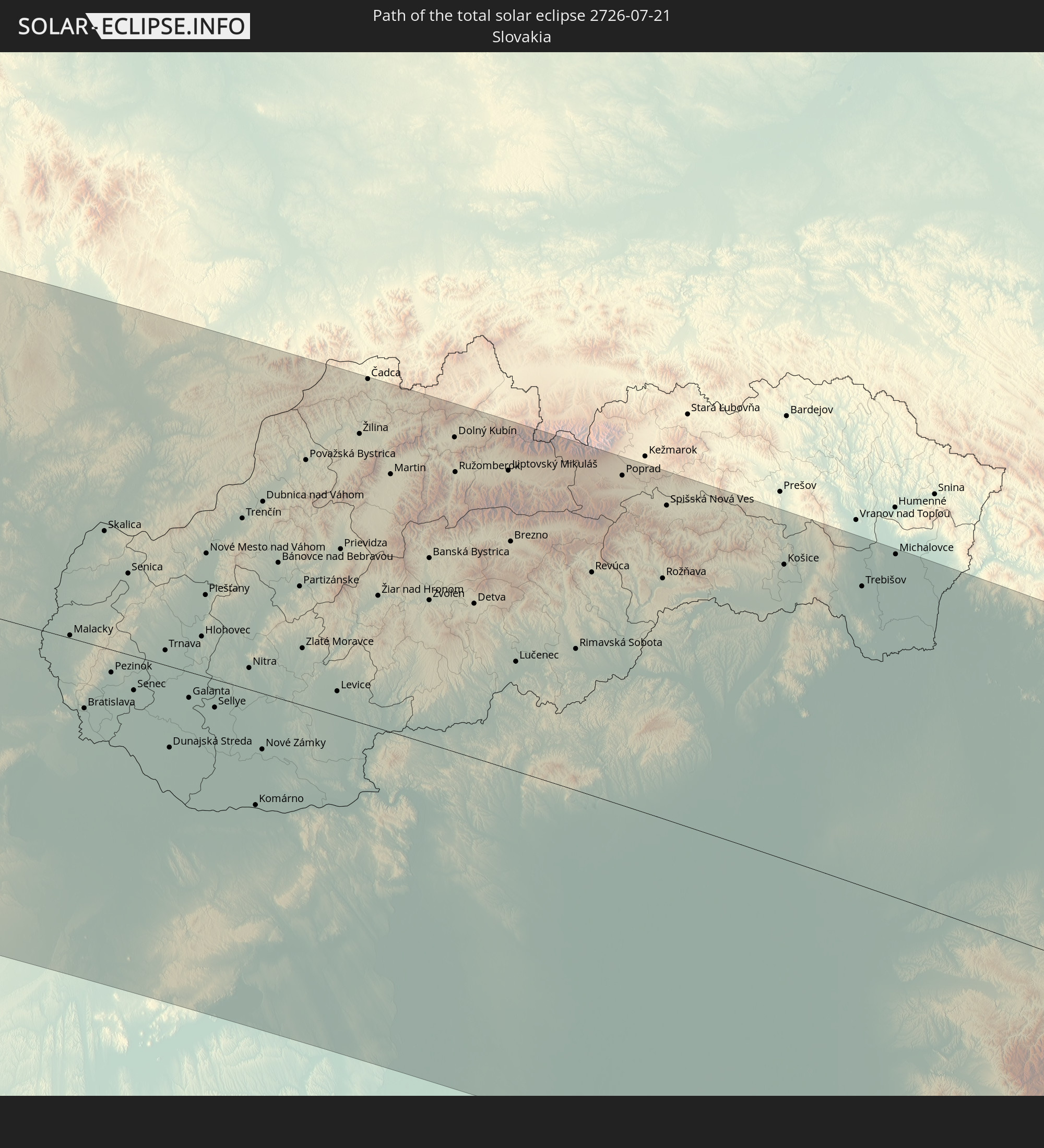 Slovakia
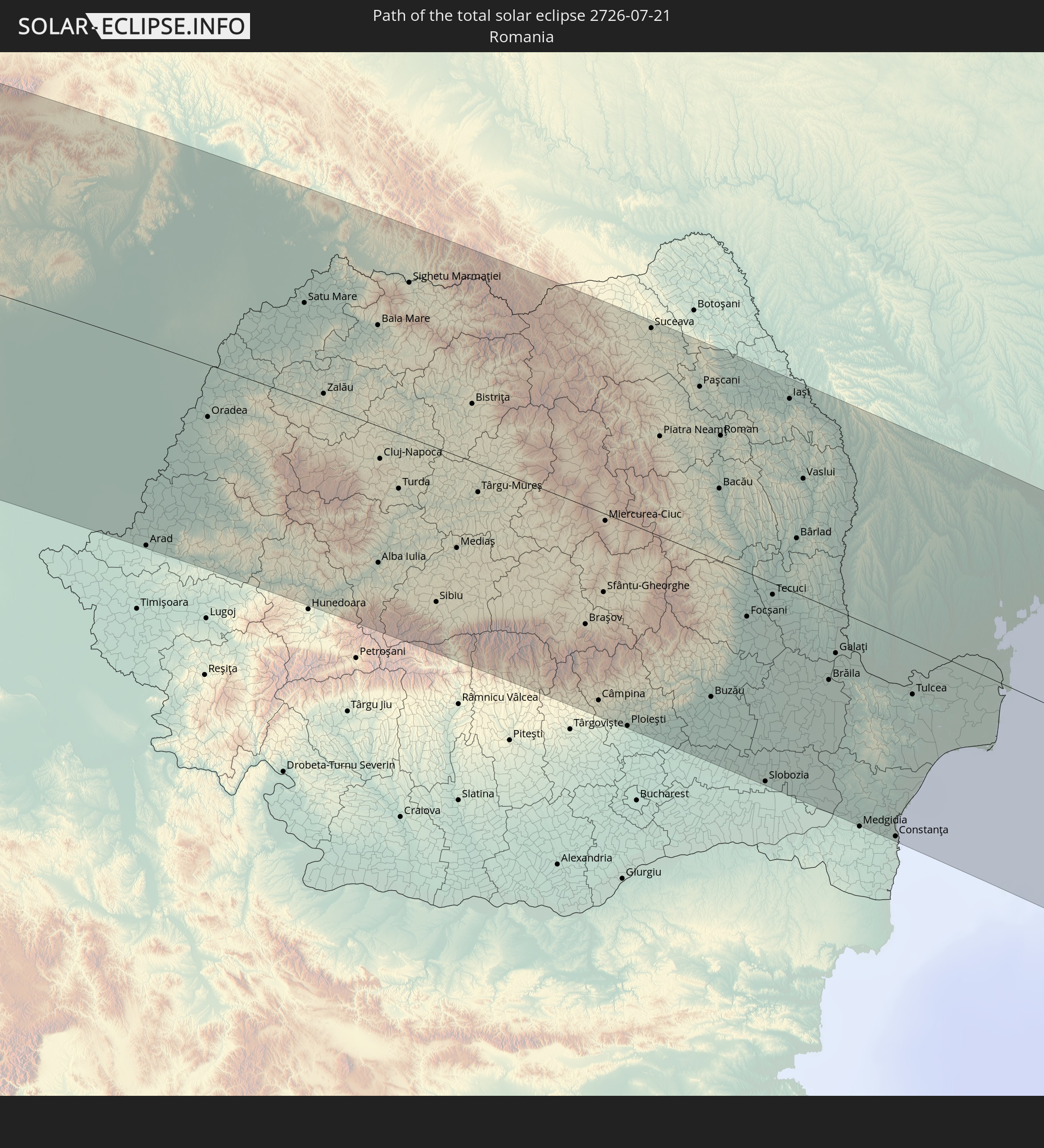 Romania
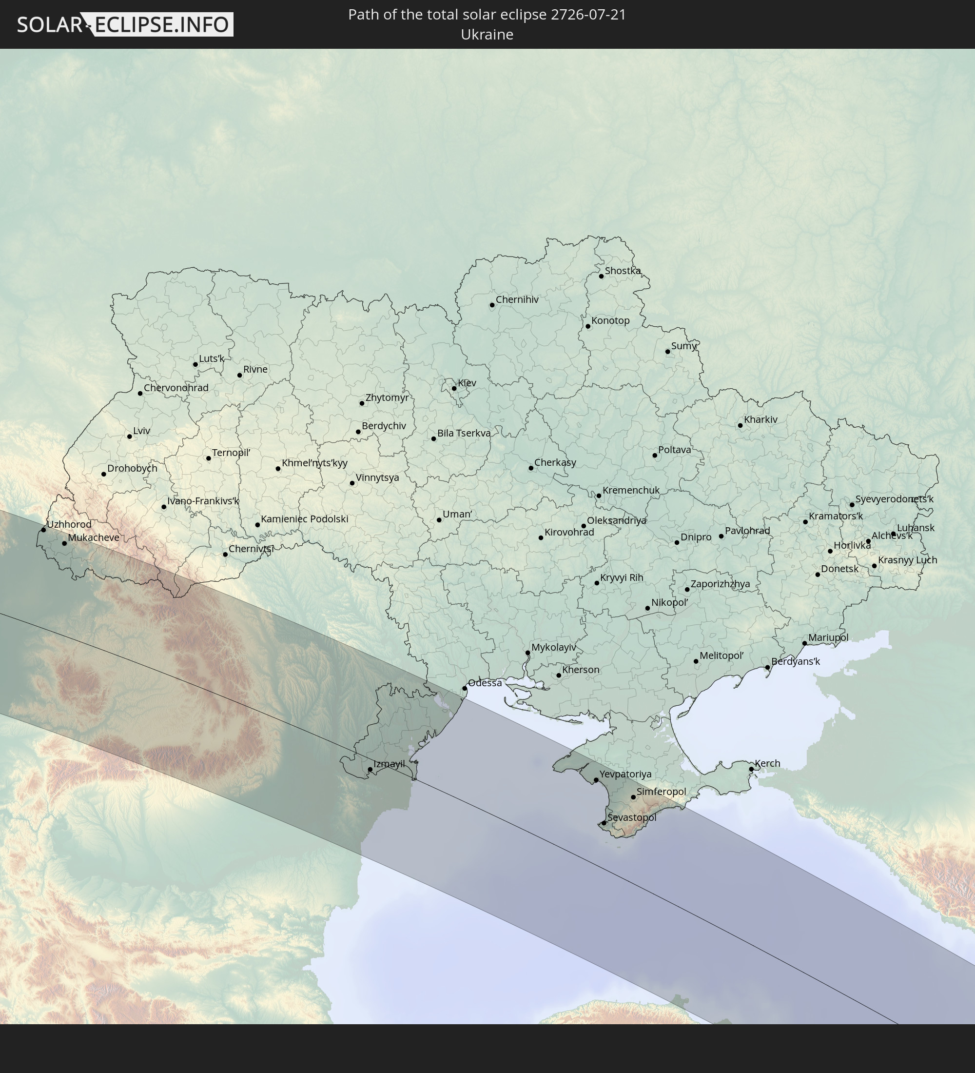 Ukraine
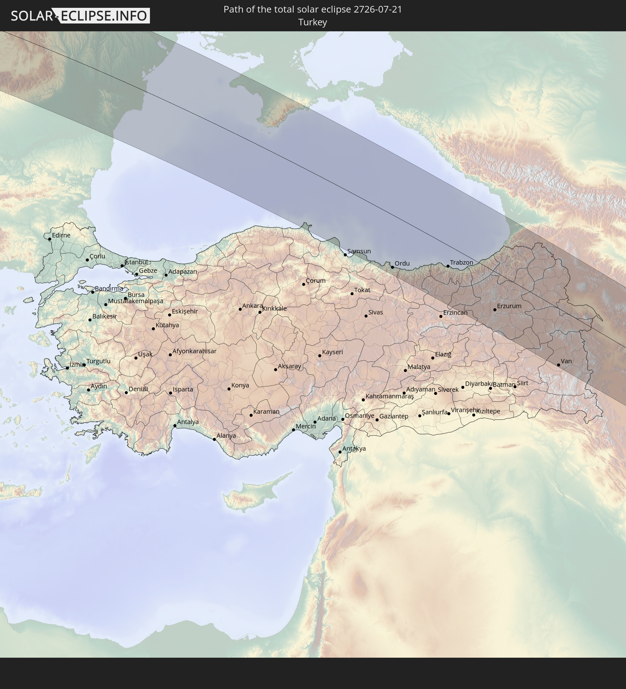 Turkey
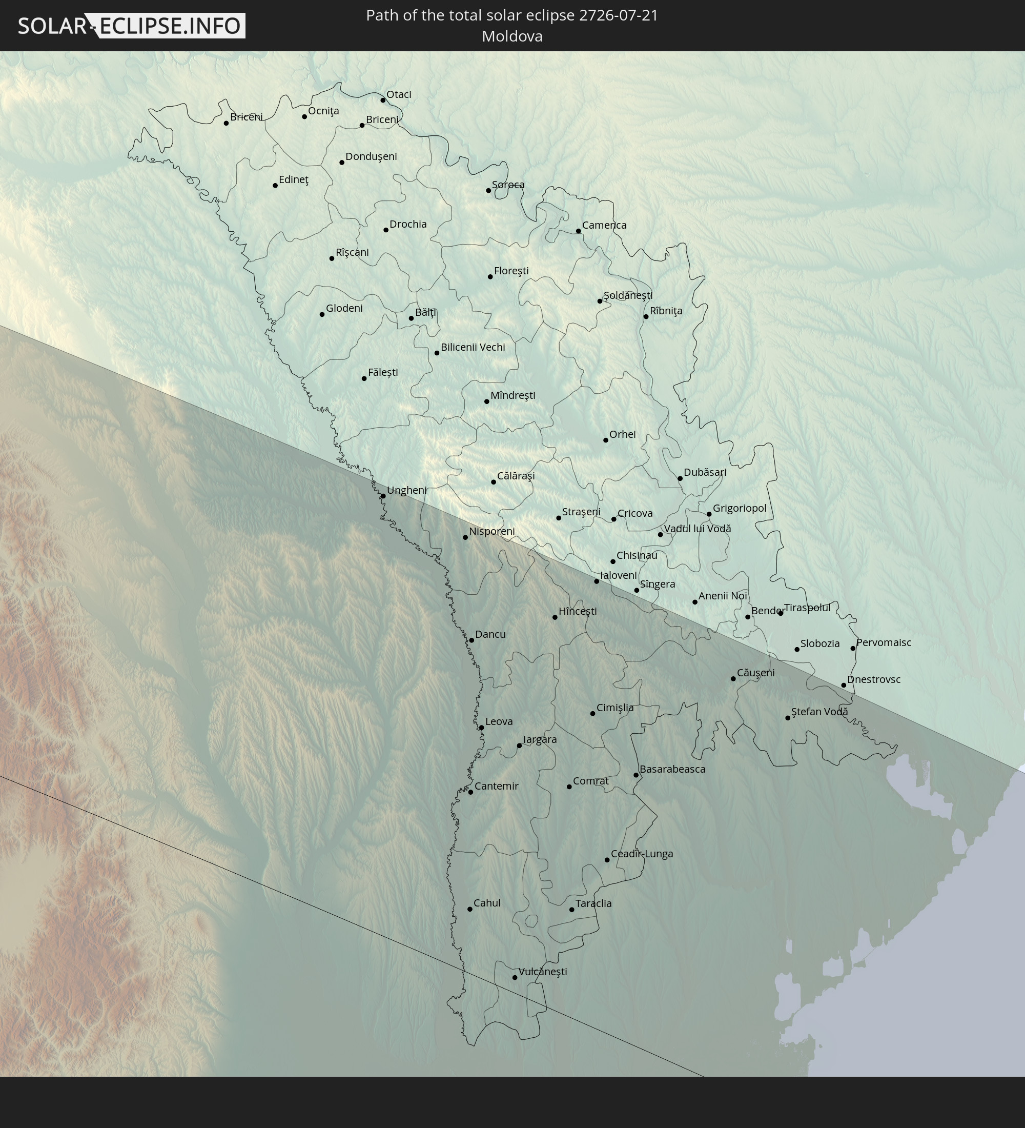 Moldova
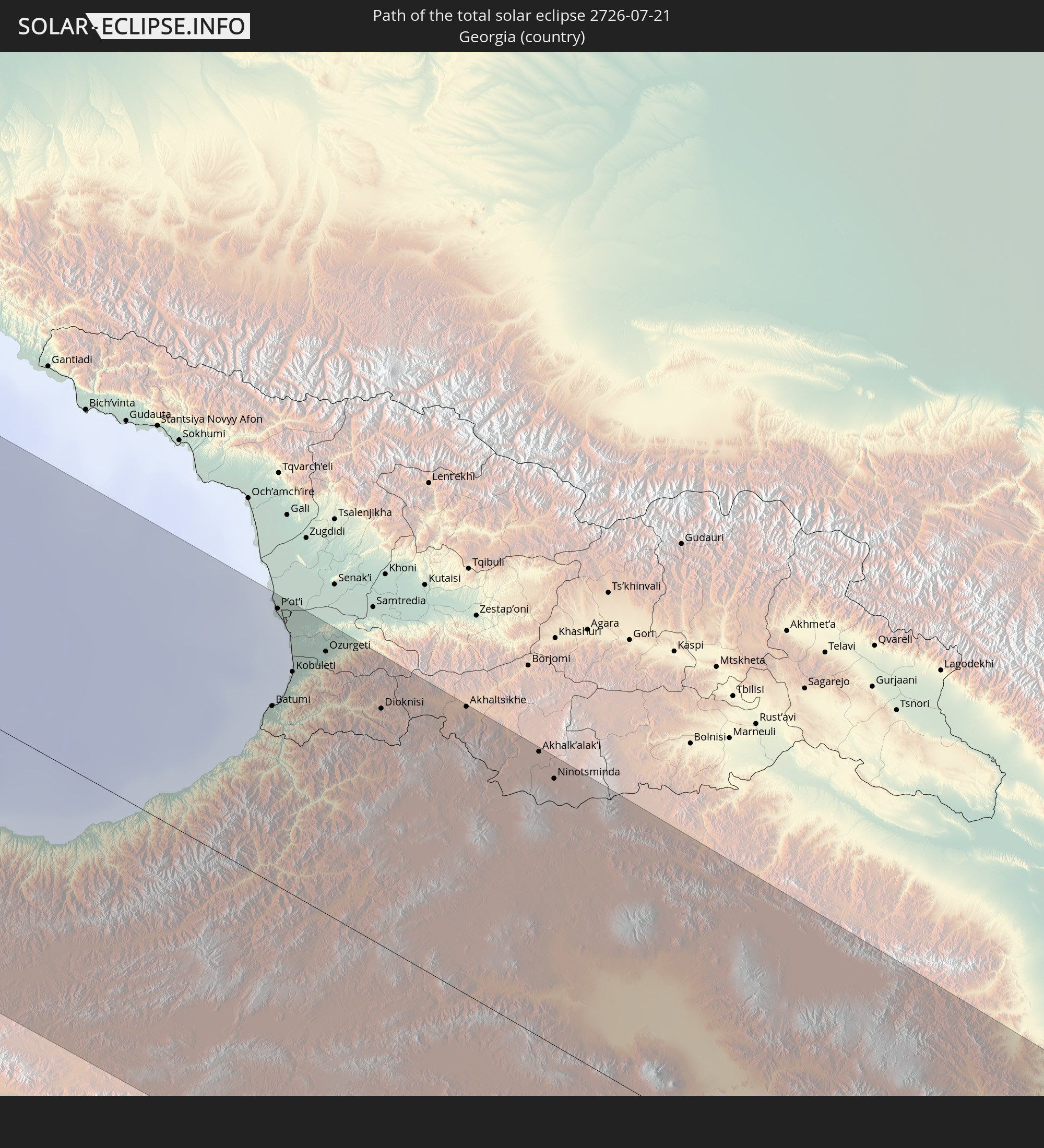 Georgia
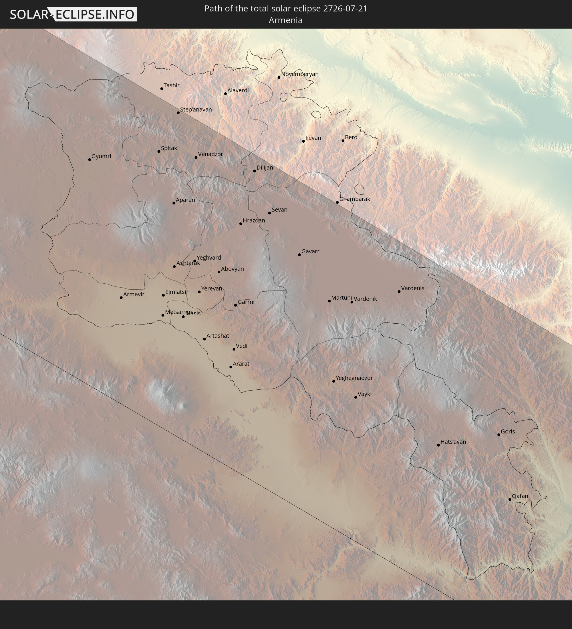 Armenia
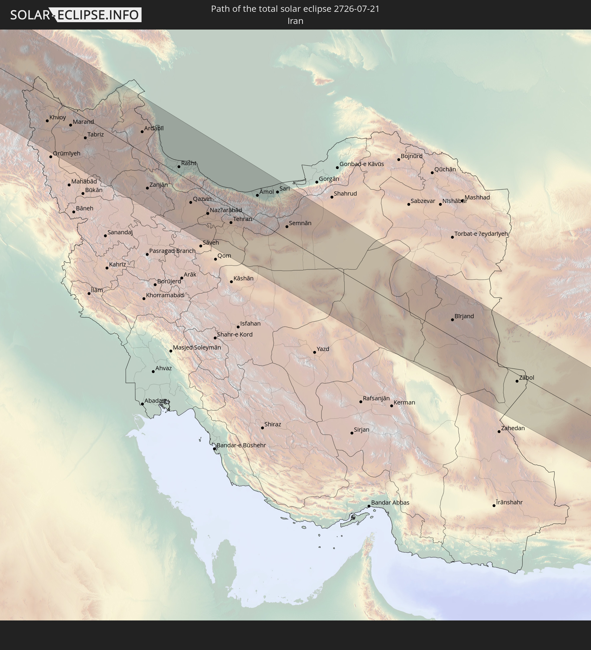 Iran
Iran
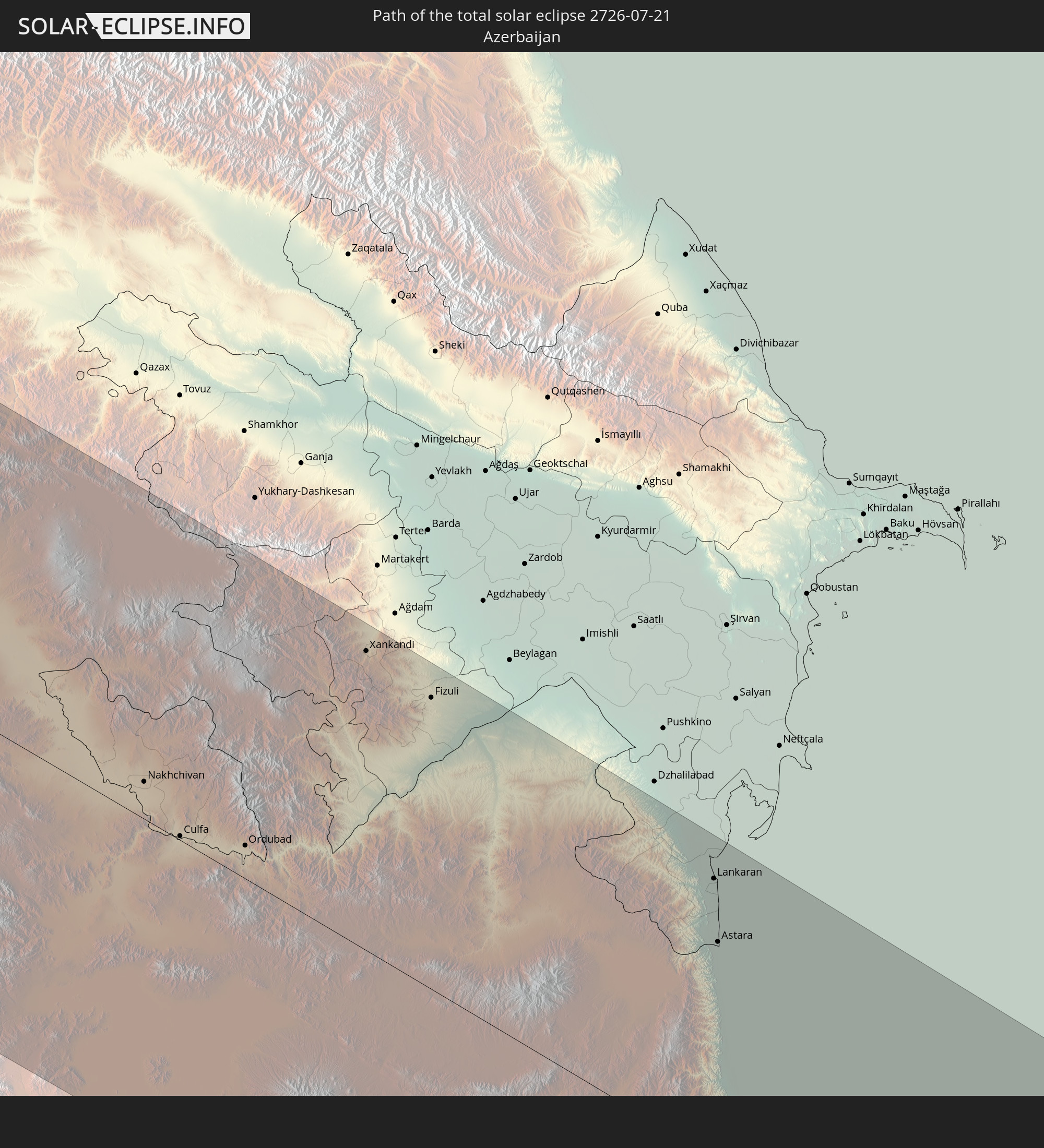 Azerbaijan
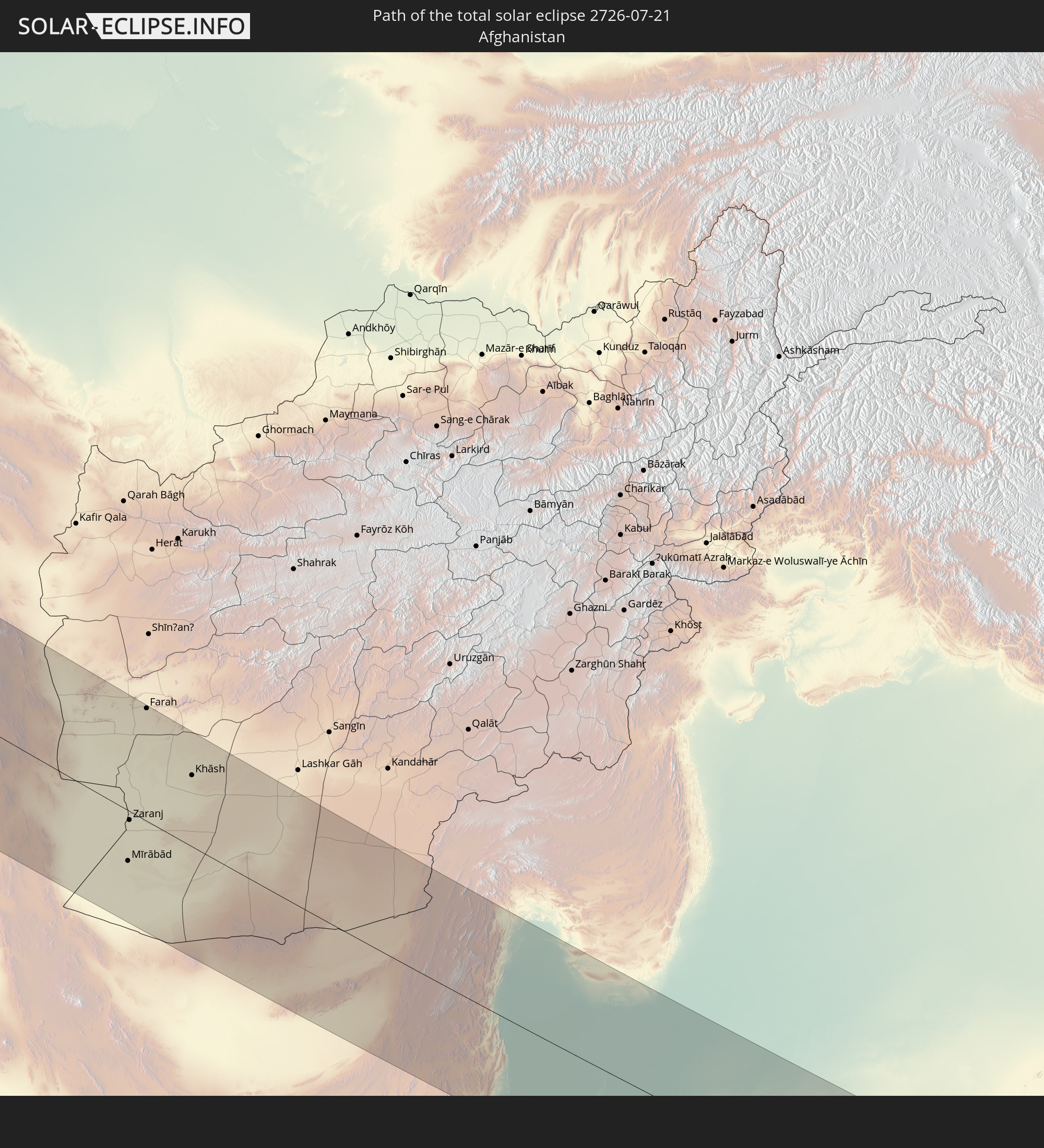 Afghanistan
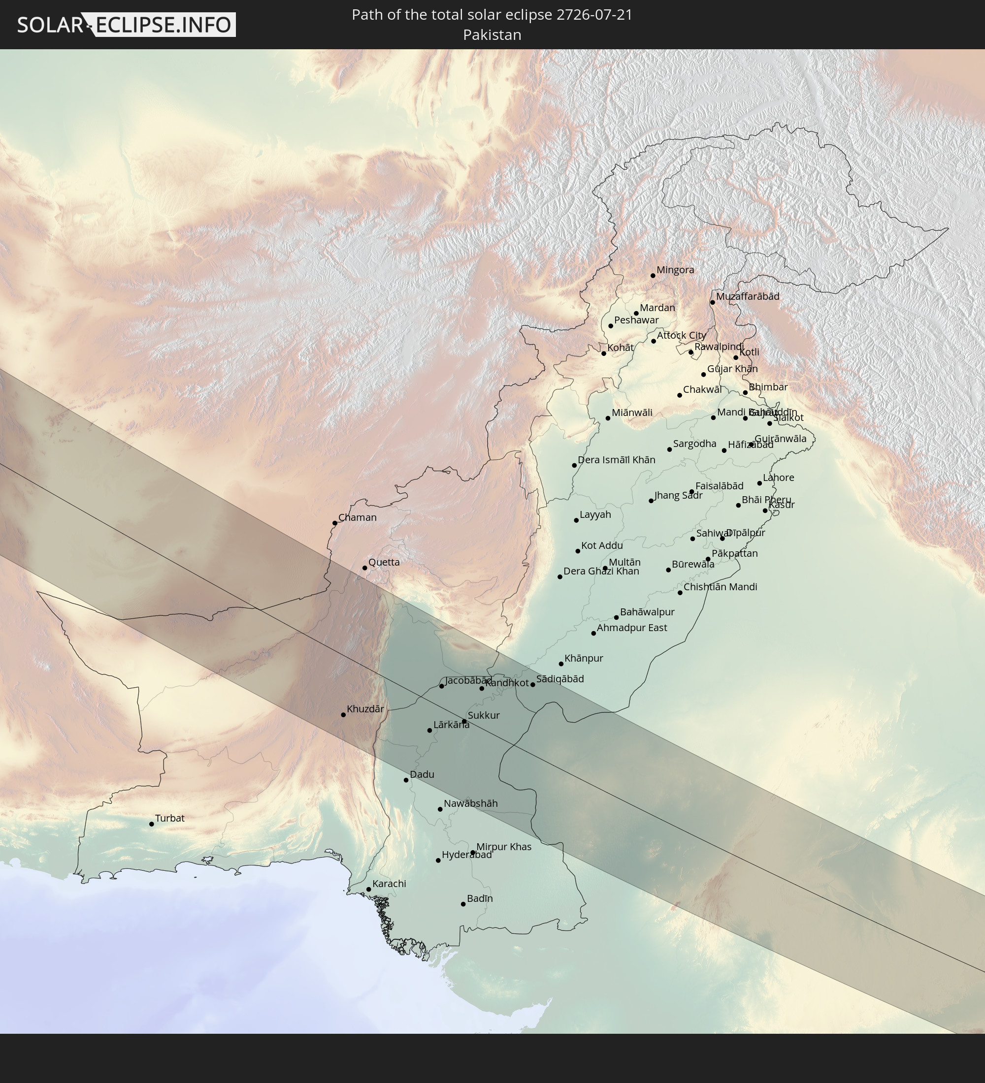 Pakistan
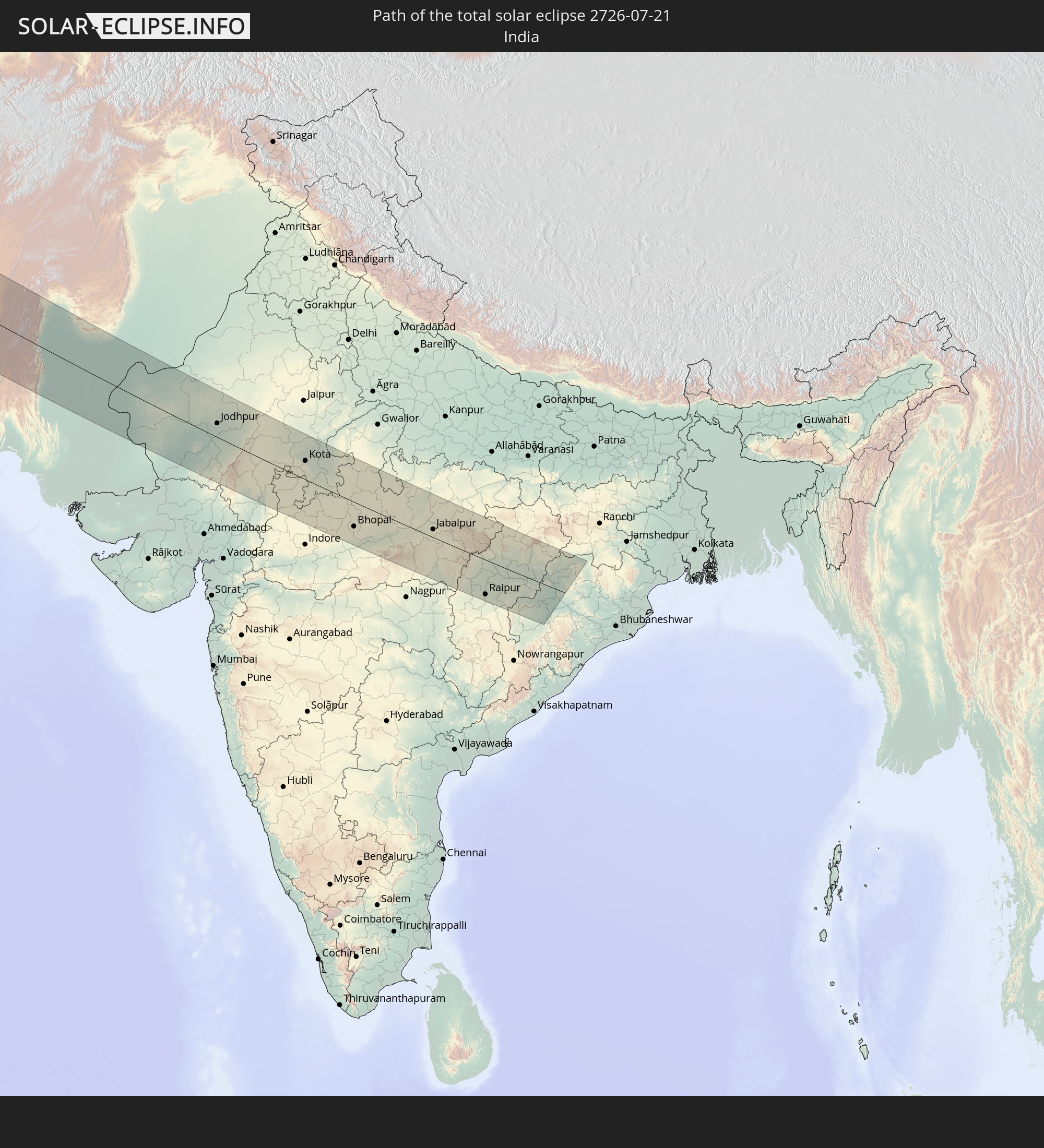 India
India
In den folgenden Ländern ist die Sonnenfinsternis partiell zu sehen
 Russia
 United States
 Canada
 Greenland
 Bermuda
 Antigua and Barbuda
 Guadeloupe
 Barbados
 Suriname
 Saint Pierre and Miquelon
 French Guiana
 Portugal
 Cabo Verde
 Iceland
 Spain
Spain
 Mauritania
 Morocco
 Mali
Mali
 Republic of Ireland
 Svalbard and Jan Mayen
 Algeria
 United Kingdom
 Faroe Islands
 Gibraltar
 France
 Isle of Man
 Guernsey
 Jersey
 Niger
Niger
 Andorra
 Belgium
 Netherlands
 Norway
 Luxembourg
 Germany
 Switzerland
 Italy
Italy
 Monaco
 Tunisia
 Denmark
 Libya
Libya
 Liechtenstein
 Austria
 Sweden
 Czechia
 San Marino
 Vatican City
 Slovenia
 Chad
Chad
 Croatia
 Poland
 Malta
Malta
 Bosnia and Herzegovina
 Hungary
 Slovakia
 Montenegro
 Serbia
 Albania
 Åland Islands
 Greece
 Romania
 Republic of Macedonia
 Finland
 Lithuania
 Latvia
 Estonia
 Sudan
Sudan
 Ukraine
 Bulgaria
 Belarus
 Egypt
Egypt
 Turkey
 Moldova
 Cyprus
 Ethiopia
 Kenya
Kenya
 State of Palestine
 Israel
 Saudi Arabia
 Jordan
 Lebanon
 Syria
Syria
 Eritrea
 Iraq
Iraq
 Georgia
 Somalia
 Djibouti
 Yemen
Yemen
 Armenia
 Iran
Iran
 Azerbaijan
 Kazakhstan
 Kuwait
 Bahrain
 Qatar
Qatar
 United Arab Emirates
 Oman
Oman
 Turkmenistan
 Uzbekistan
 Afghanistan
 Pakistan
 Tajikistan
 India
India
 Kyrgyzstan
 Maldives
 China
China
 Nepal
Nepal
 Mongolia
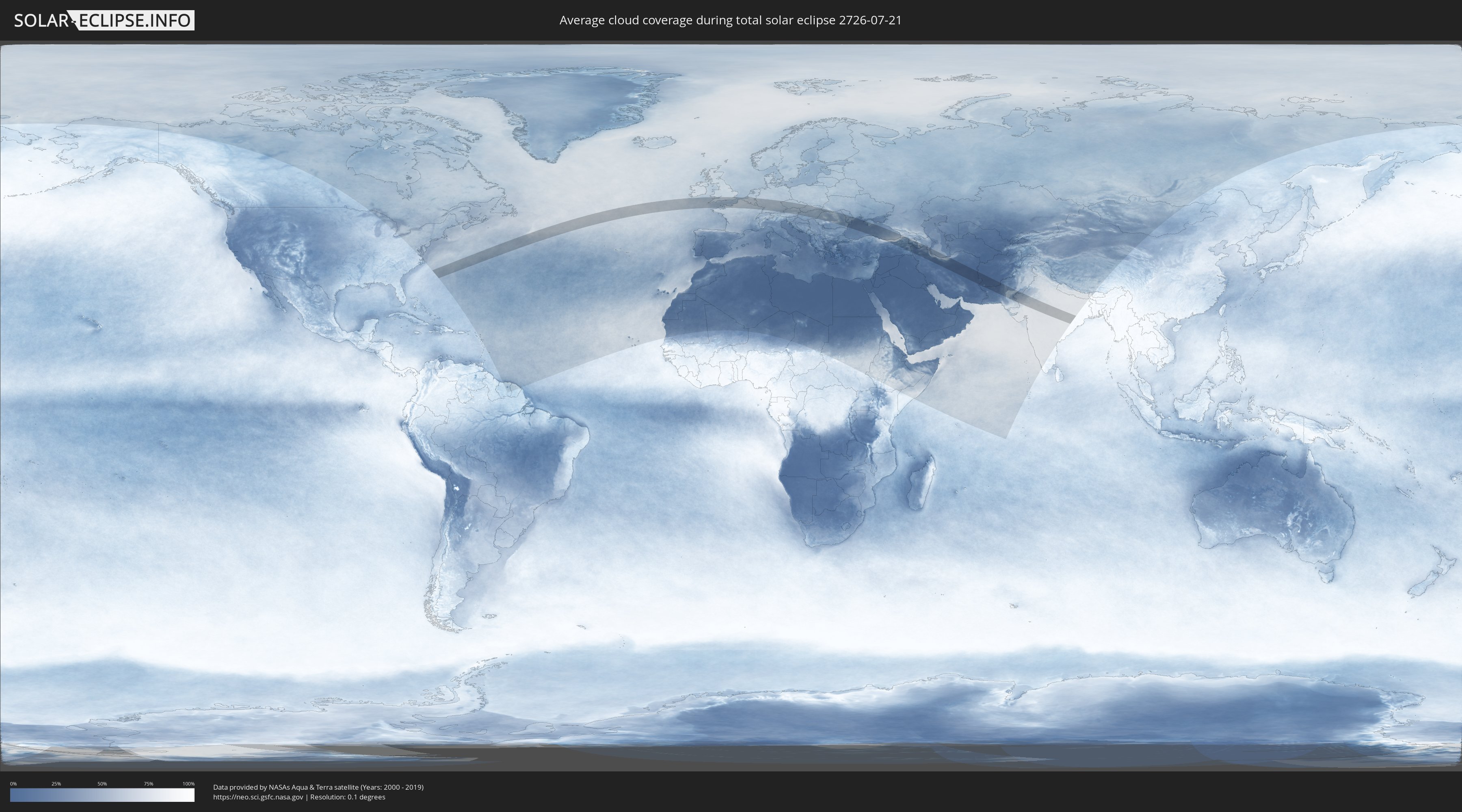
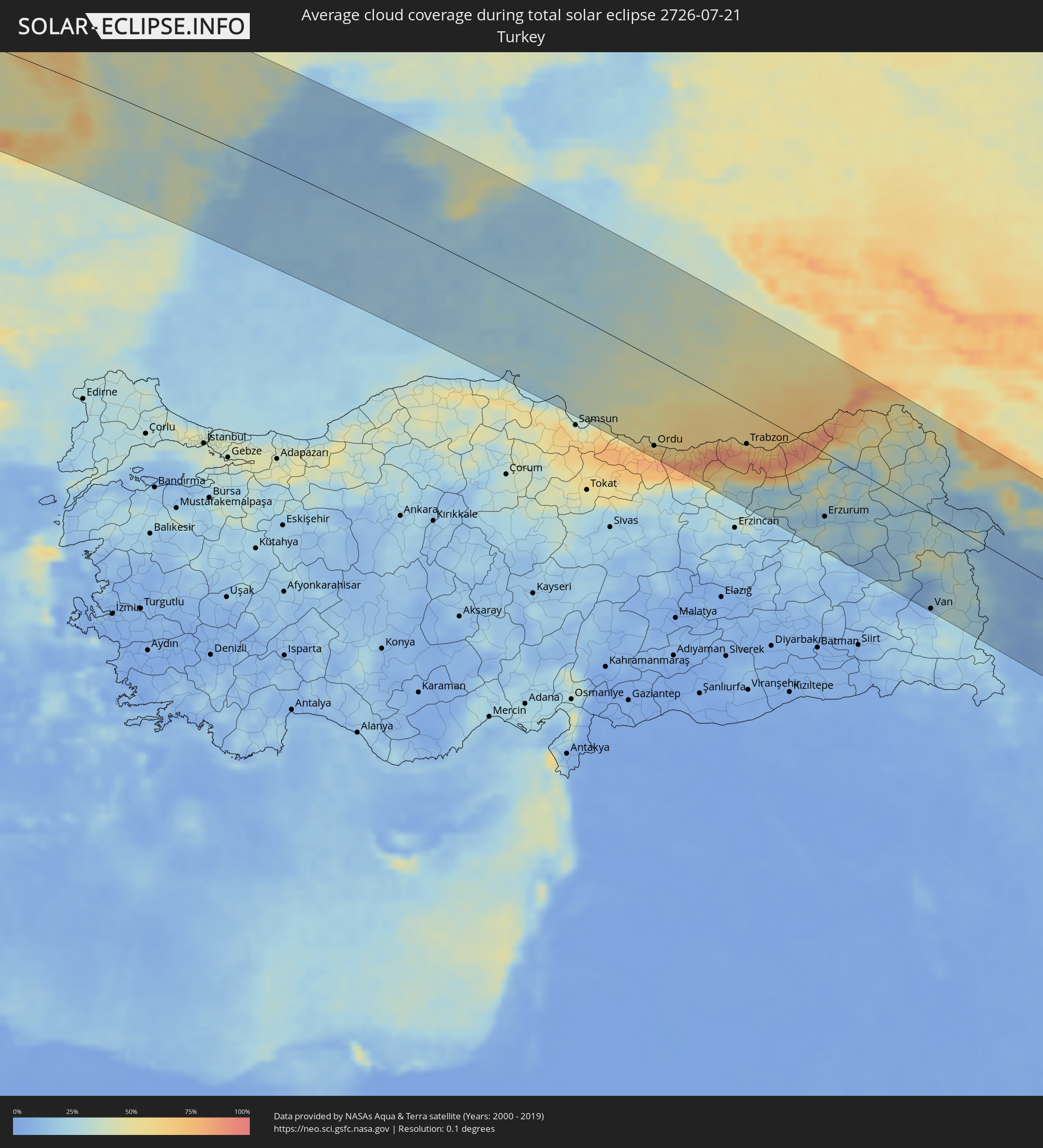
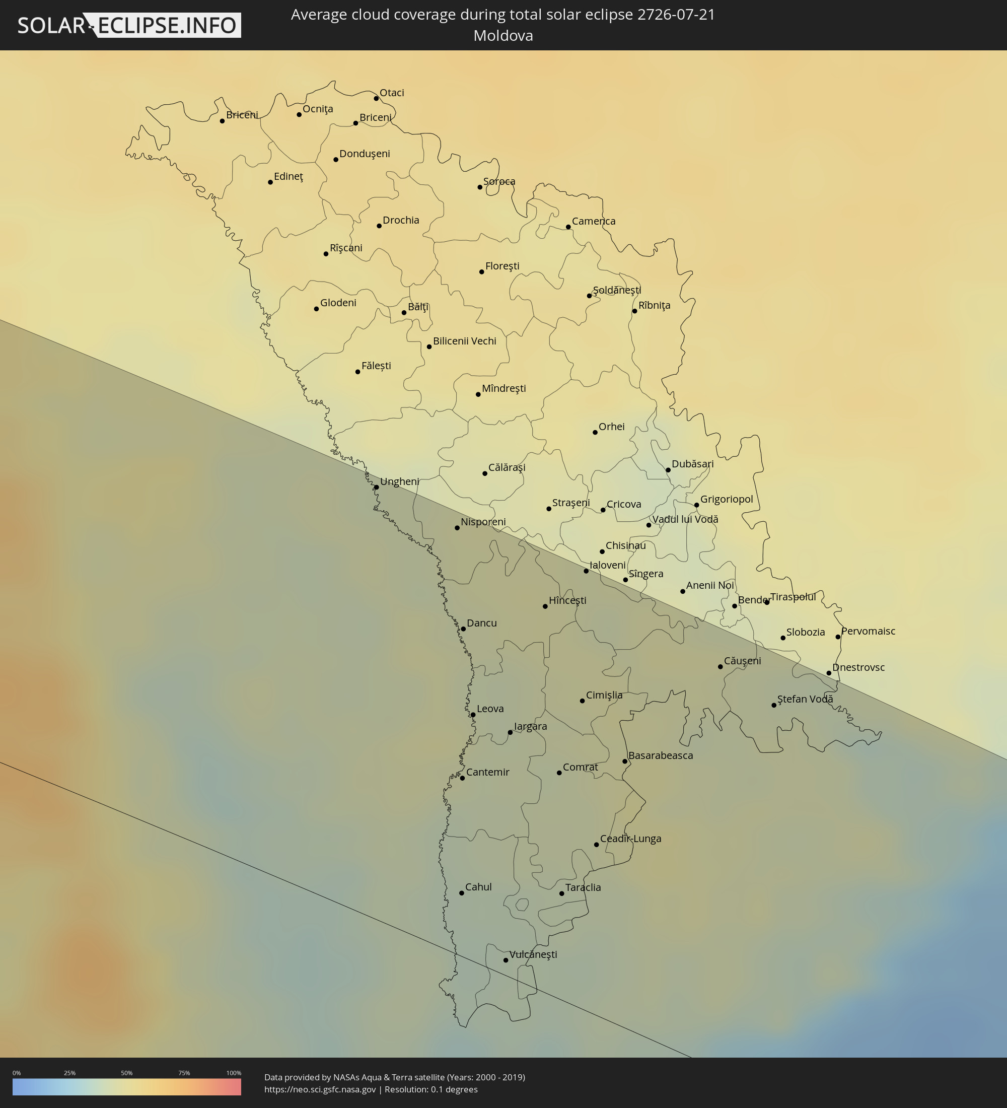
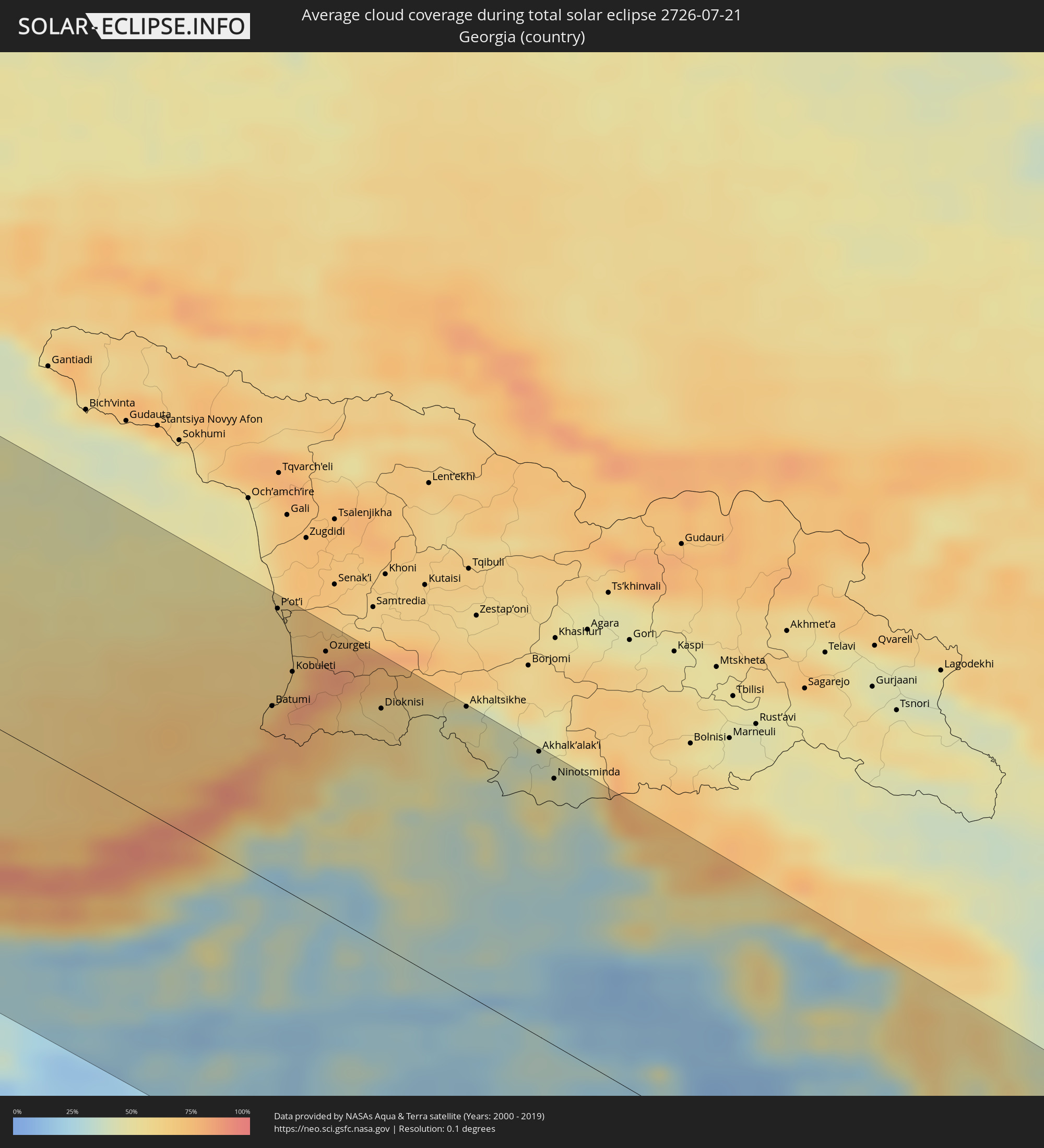
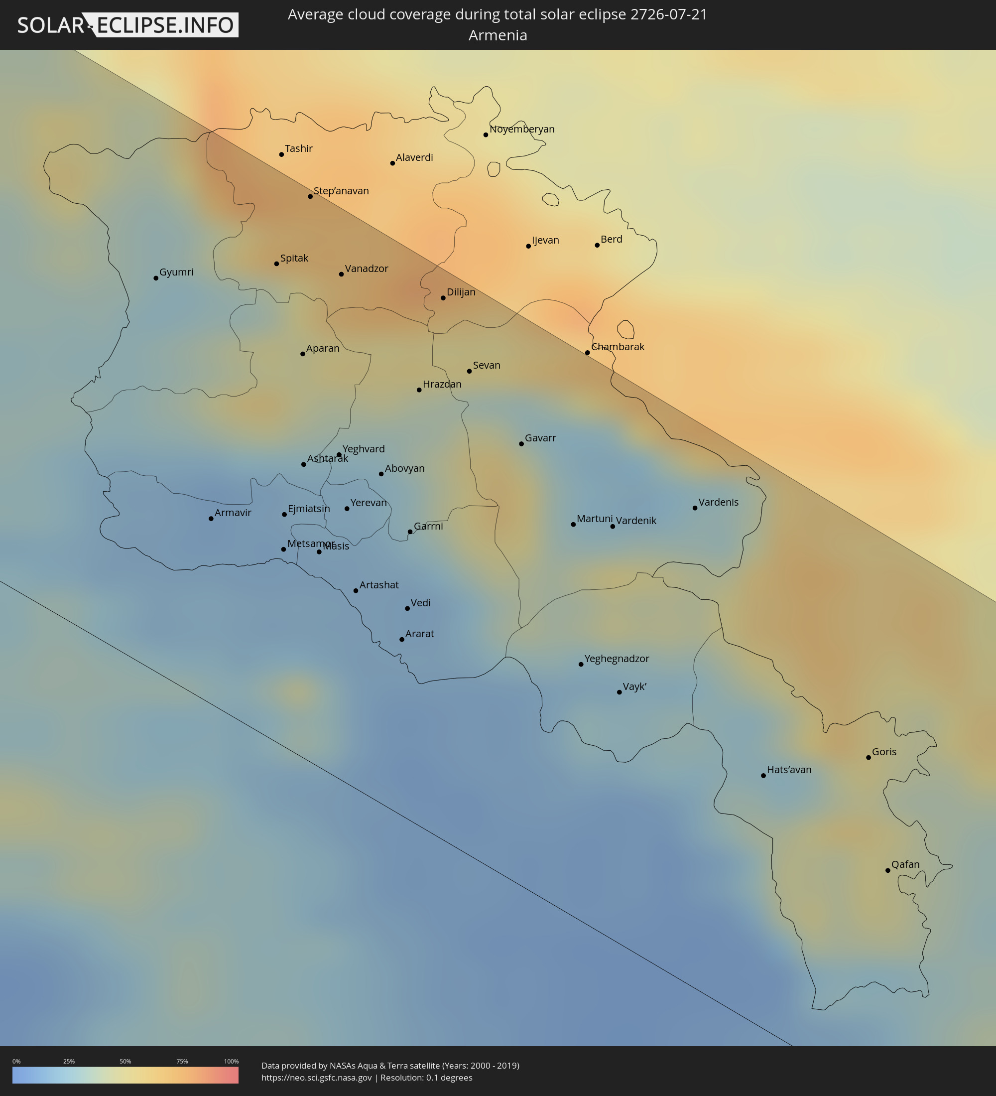
How will be the weather during the total solar eclipse on 07/21/2726?
Where is the best place to see the total solar eclipse of 07/21/2726?
The following maps show the average cloud coverage for the day of the total solar eclipse.
With the help of these maps, it is possible to find the place along the eclipse path, which has the best
chance of a cloudless sky.
Nevertheless, you should consider local circumstances and inform about the weather of your chosen
observation site.
The data is provided by NASAs satellites
AQUA and TERRA.
The cloud maps are averaged over a period of 19 years (2000 - 2019).

Detailed country maps
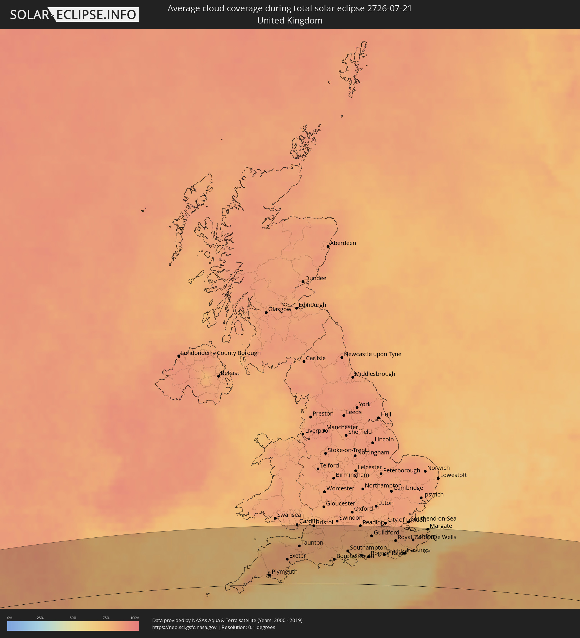 United Kingdom
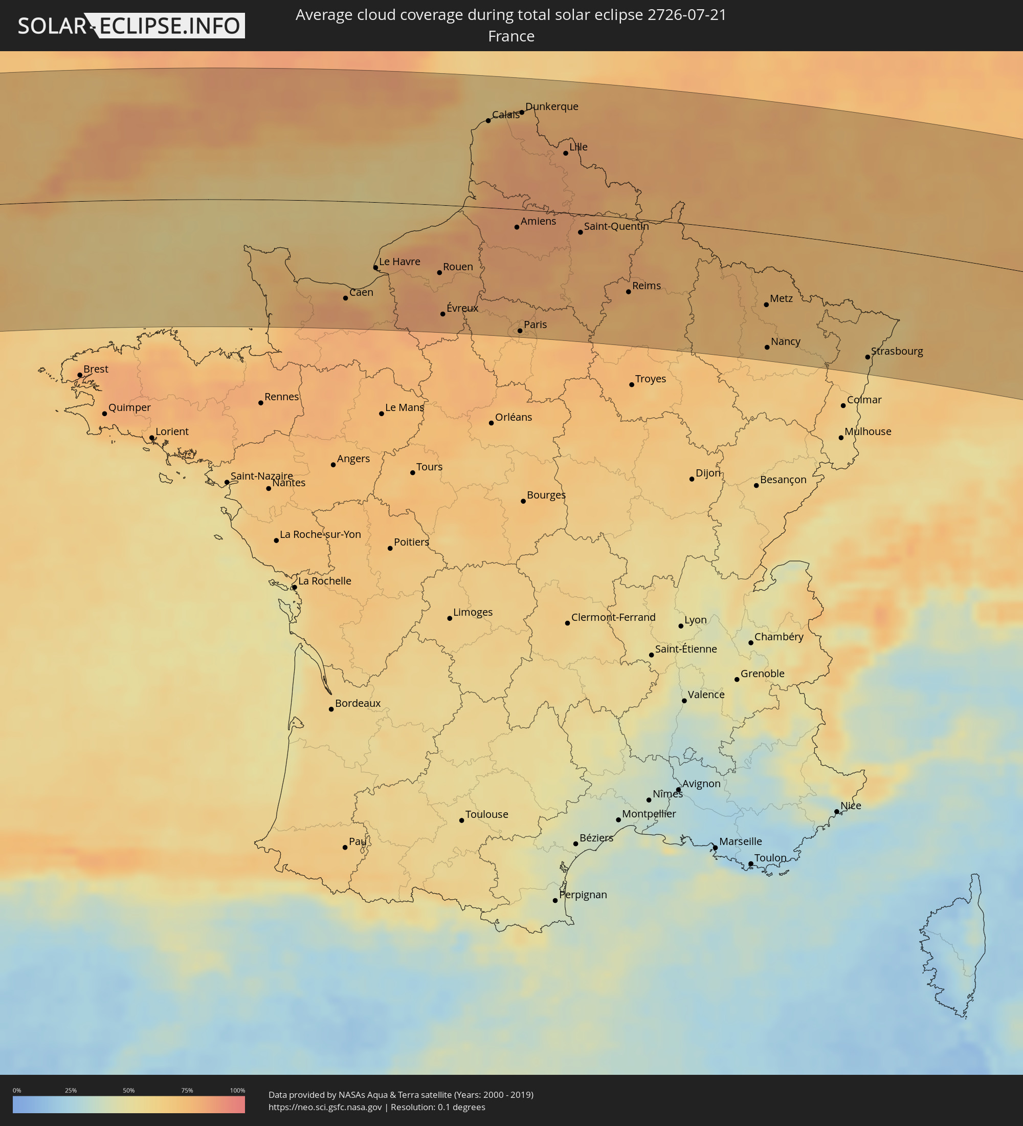 France
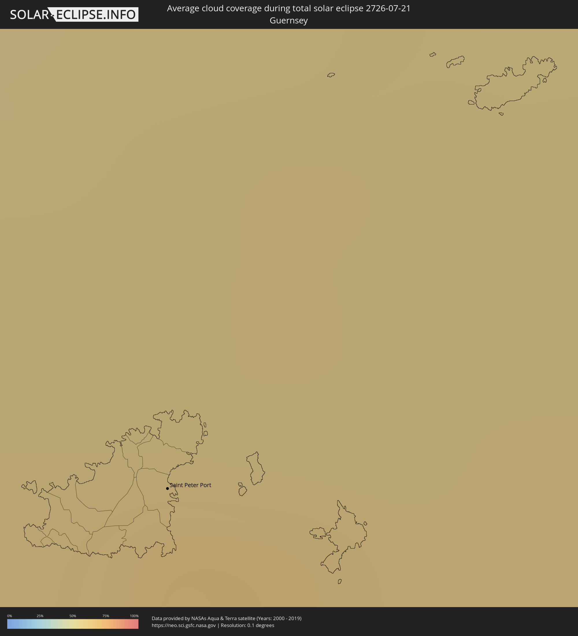 Guernsey
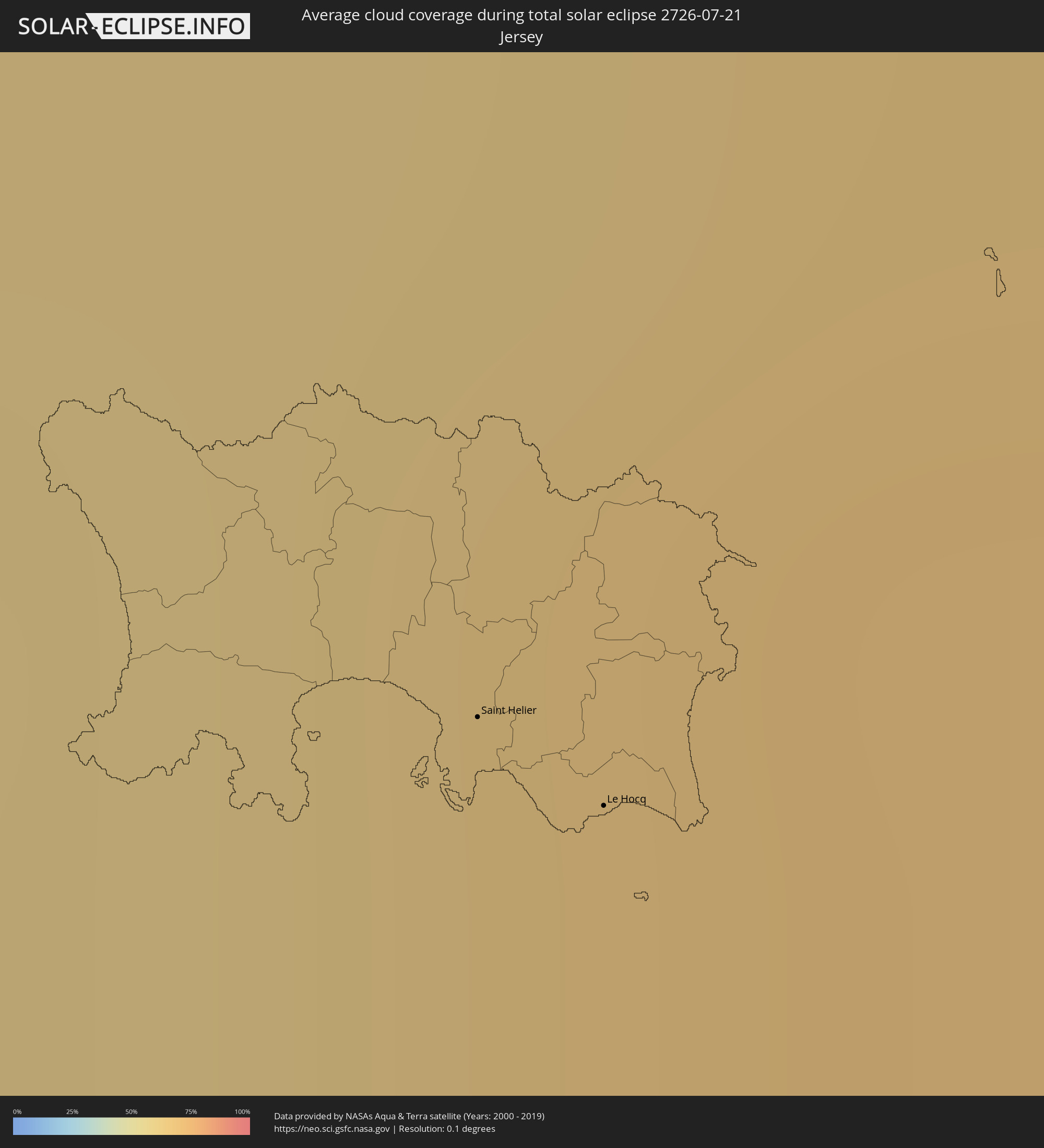 Jersey
 Belgium
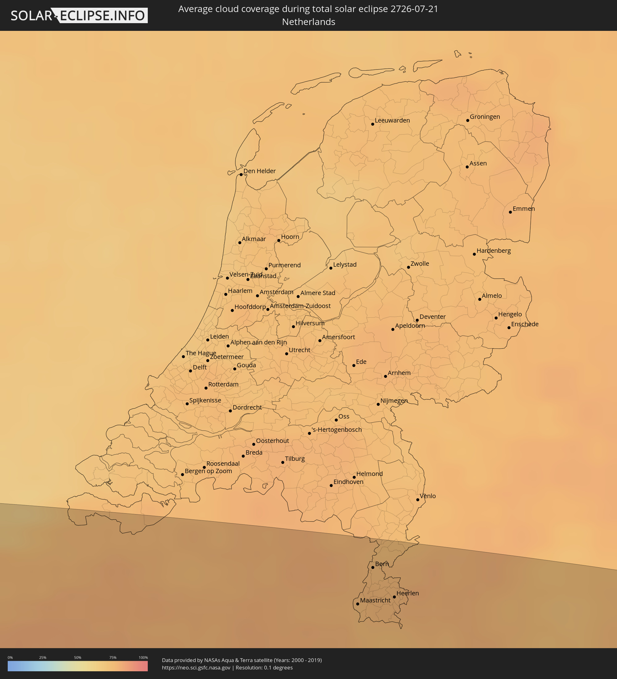 Netherlands
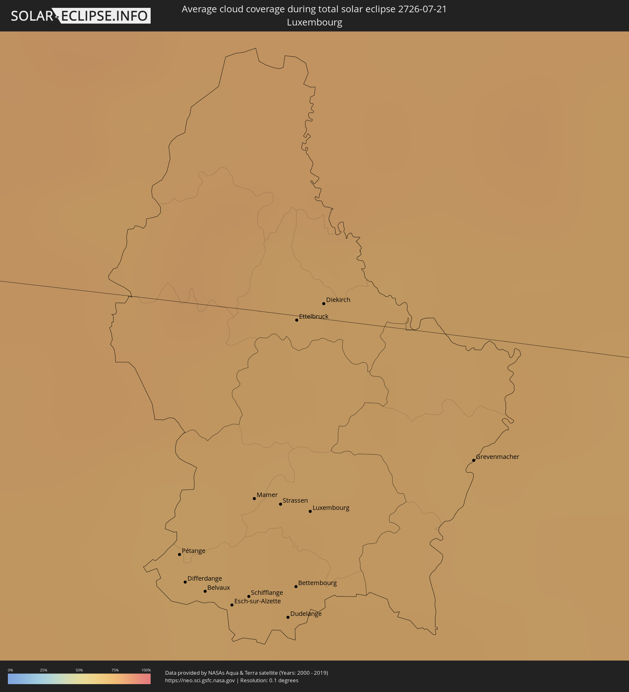 Luxembourg
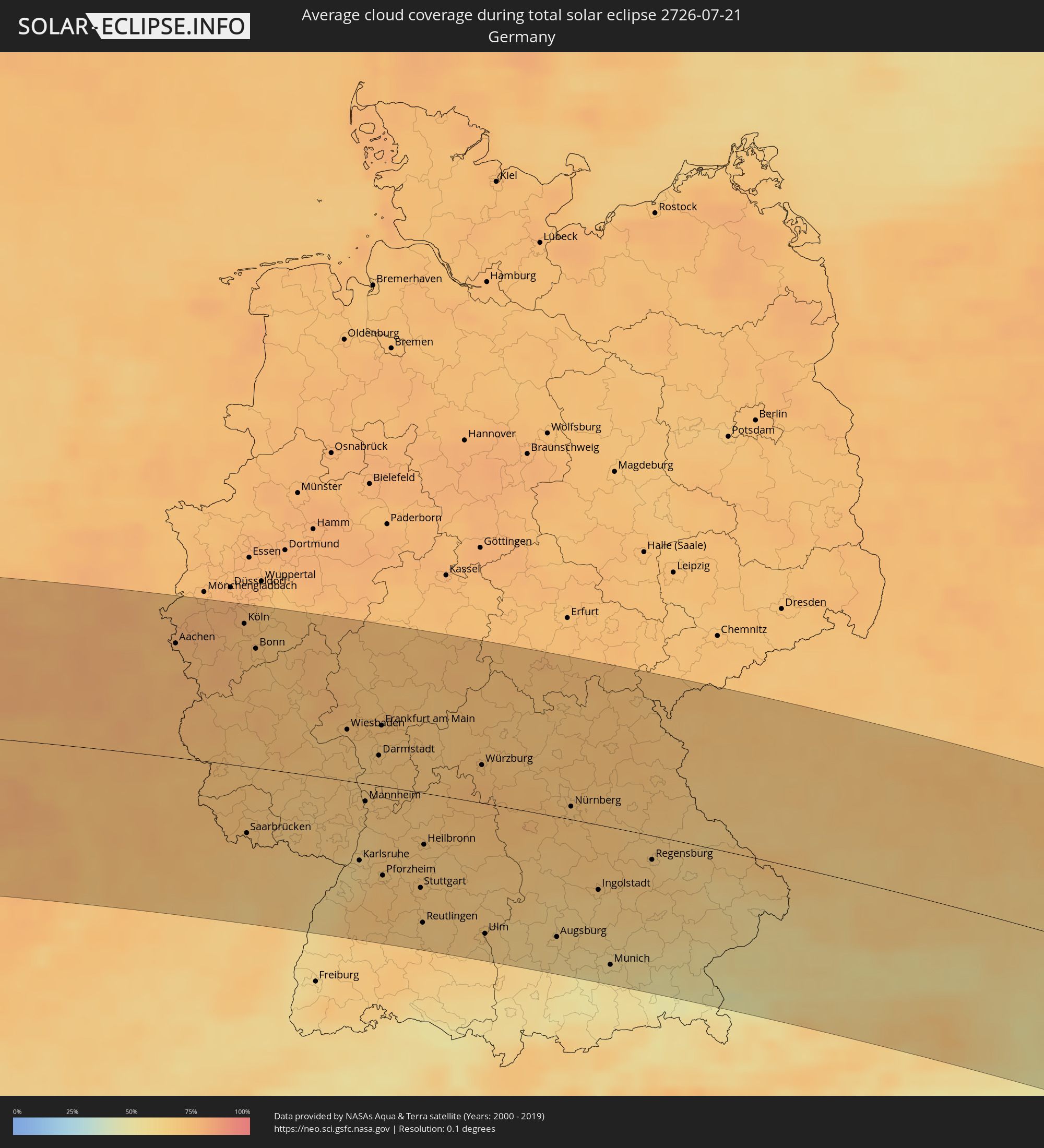 Germany
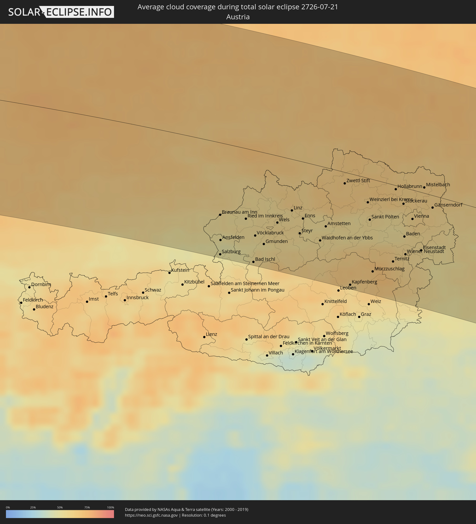 Austria
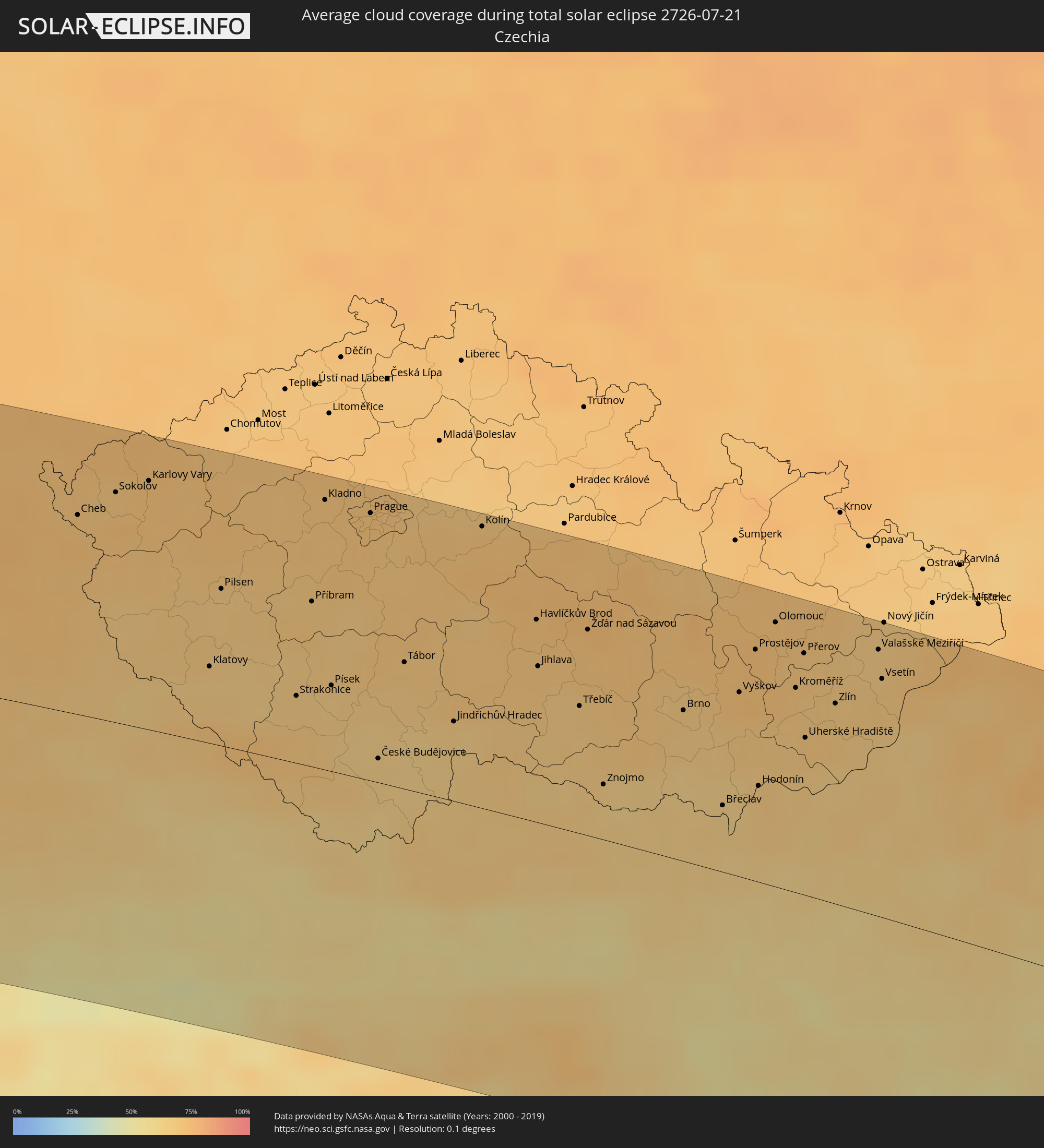 Czechia
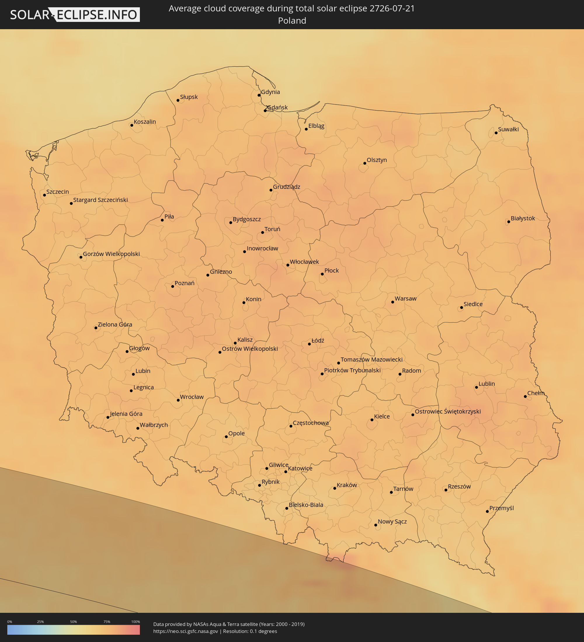 Poland
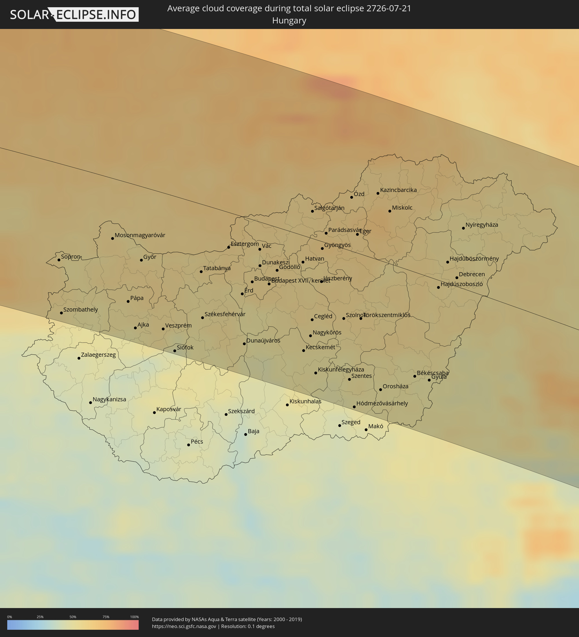 Hungary
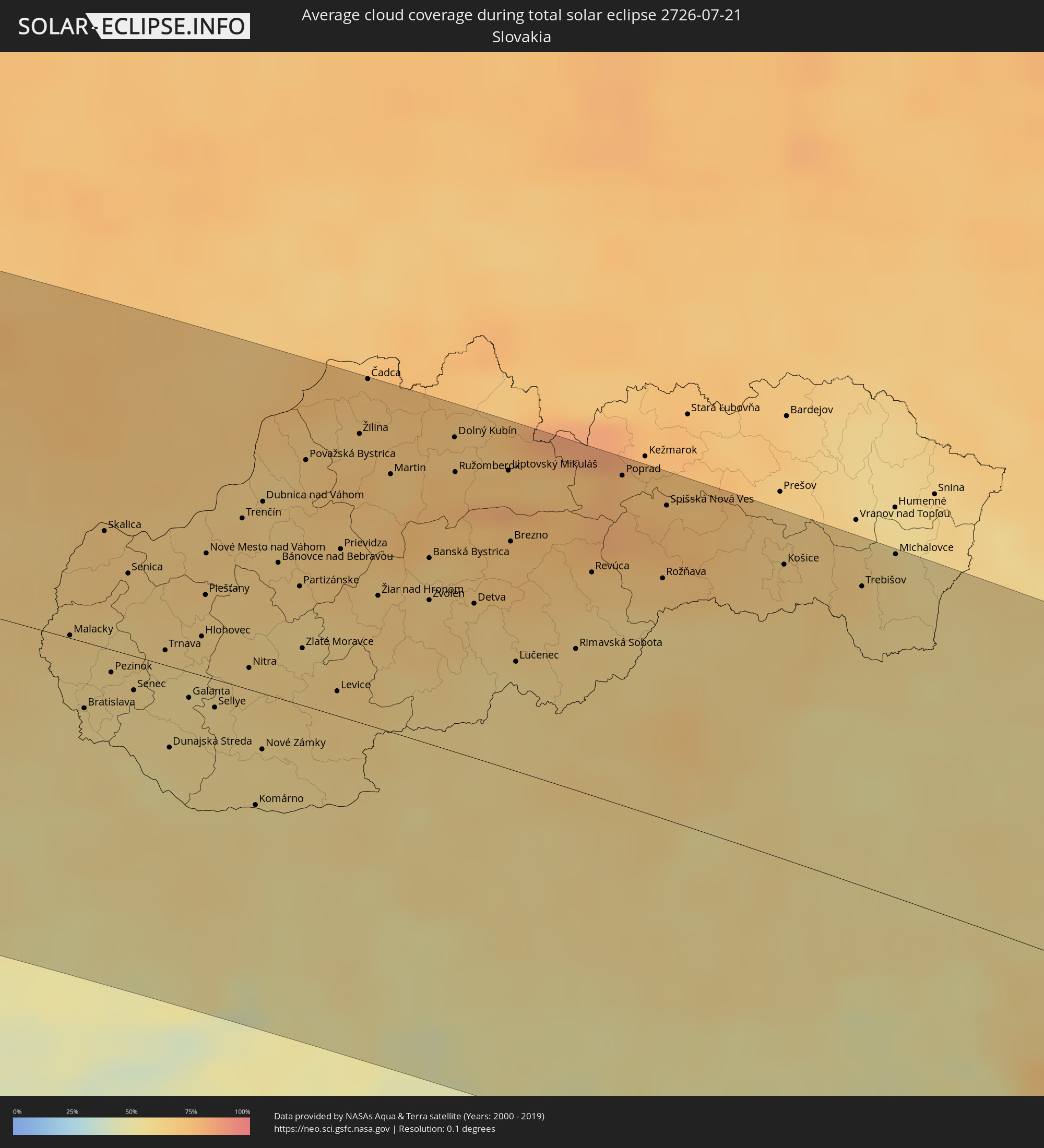 Slovakia
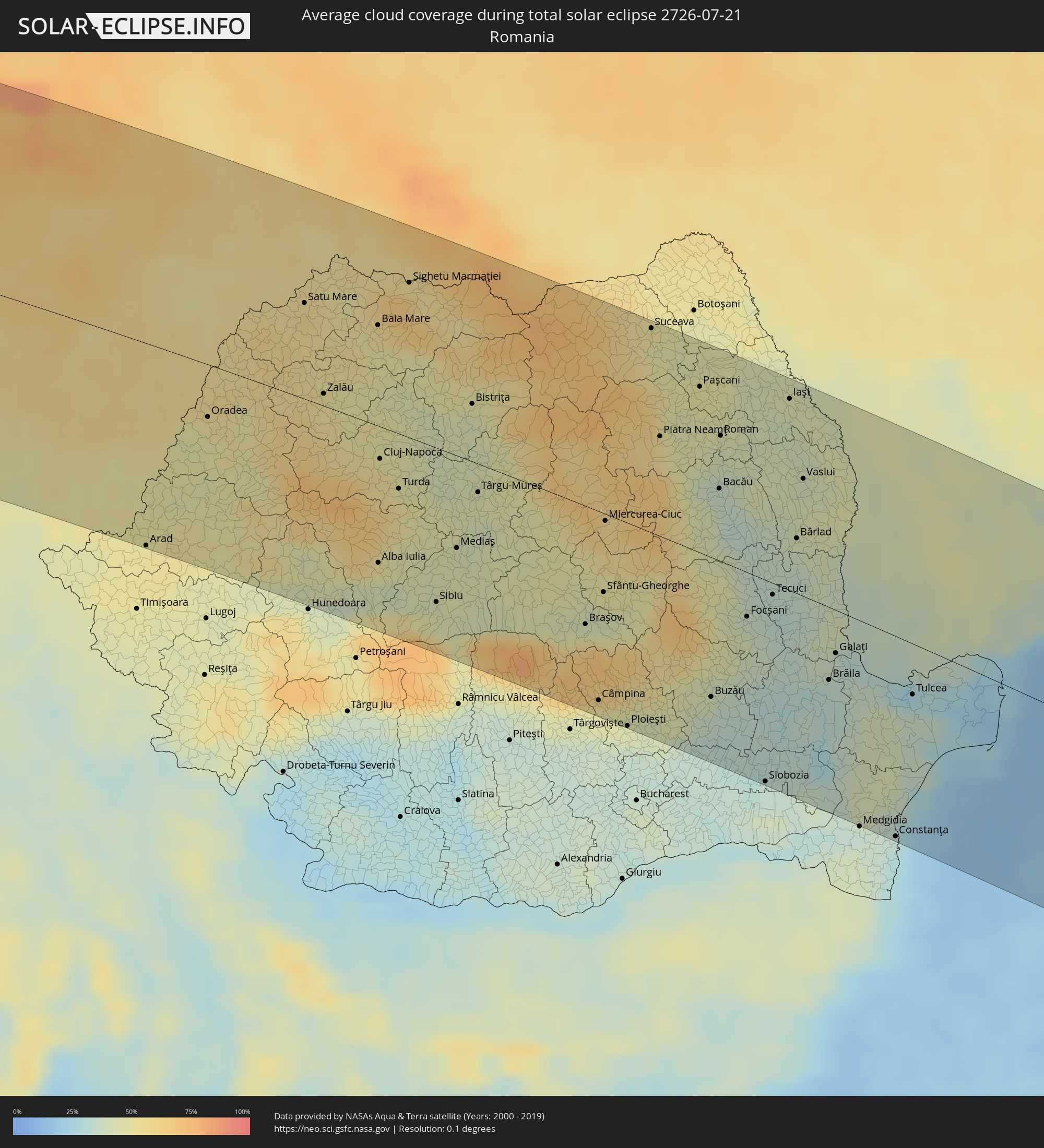 Romania
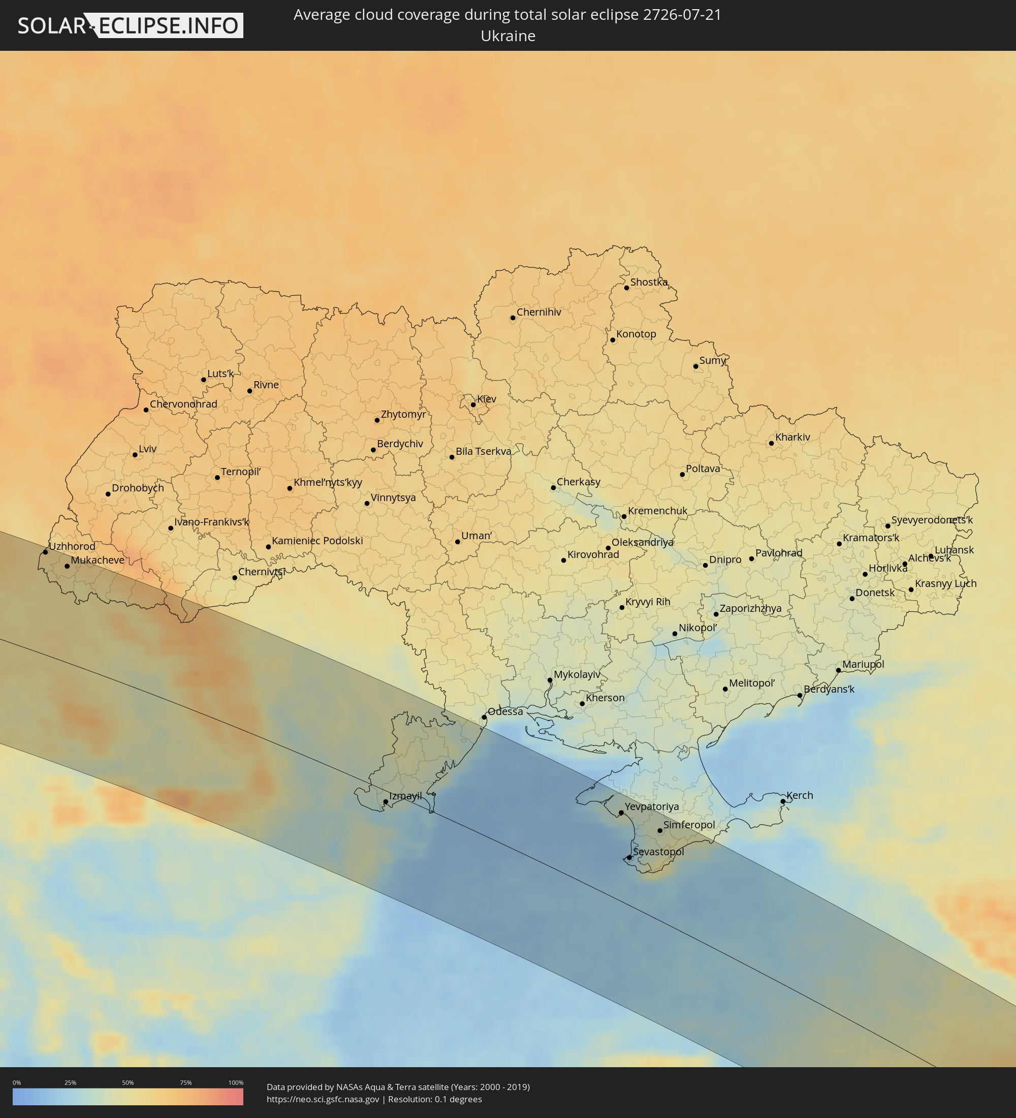 Ukraine
 Turkey
 Moldova
 Georgia
 Armenia
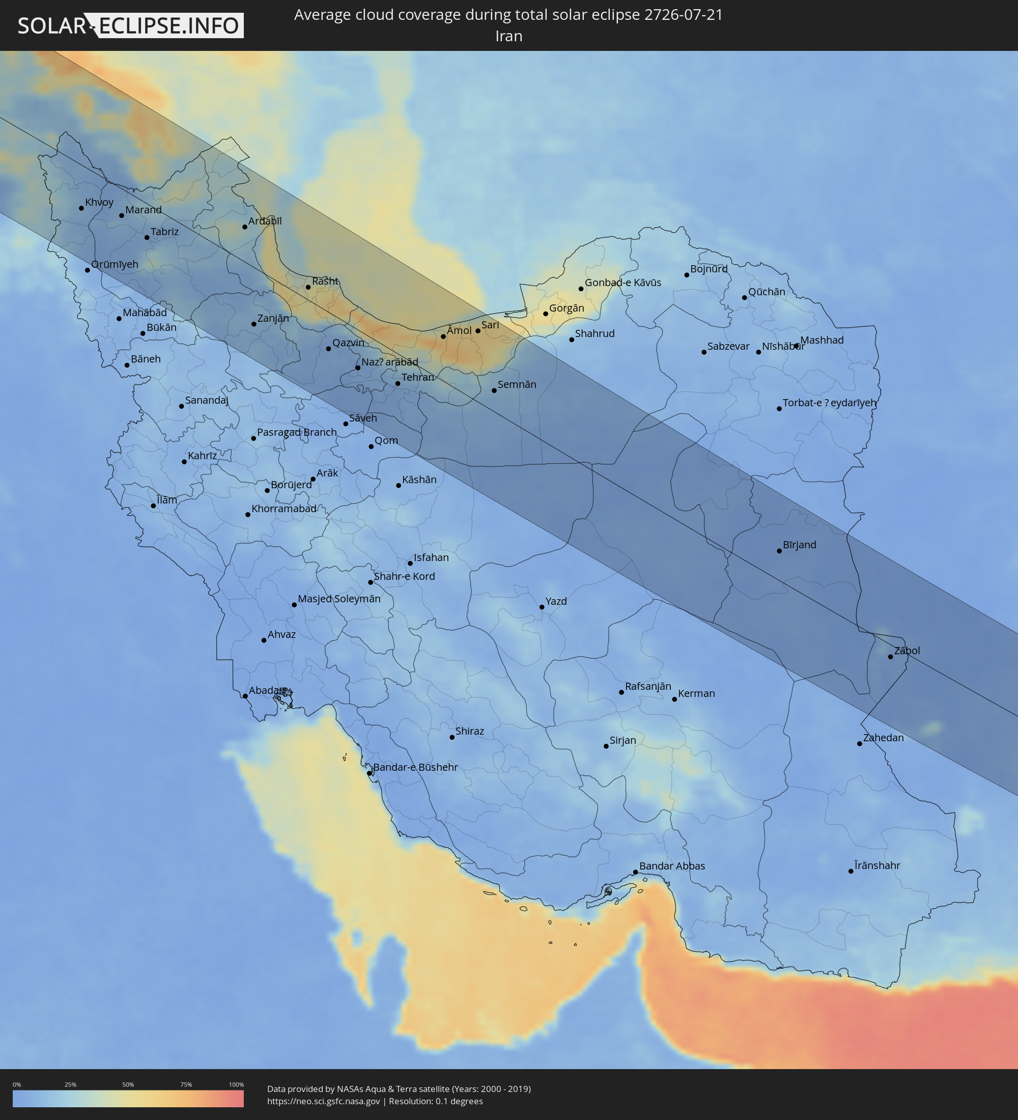 Iran
Iran
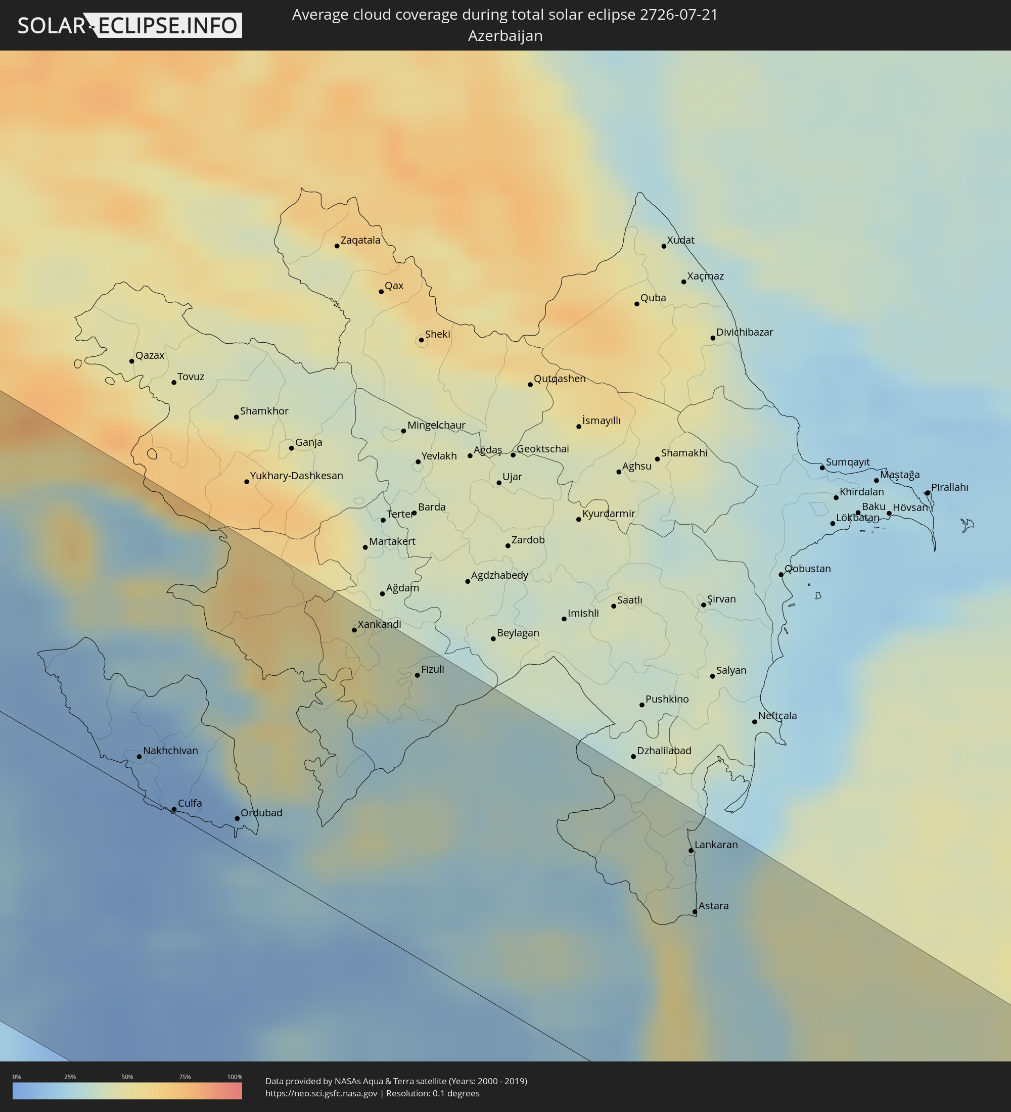 Azerbaijan
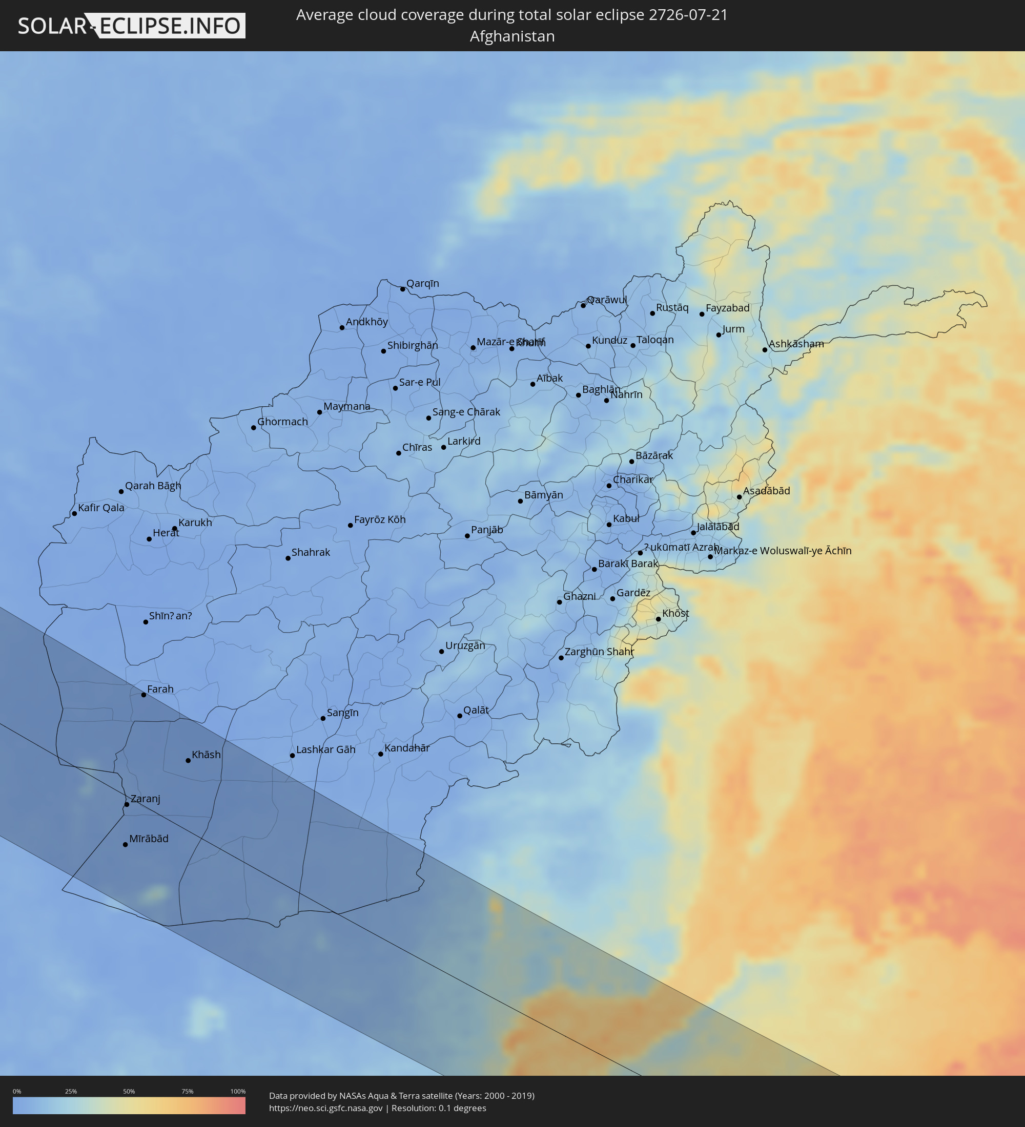 Afghanistan
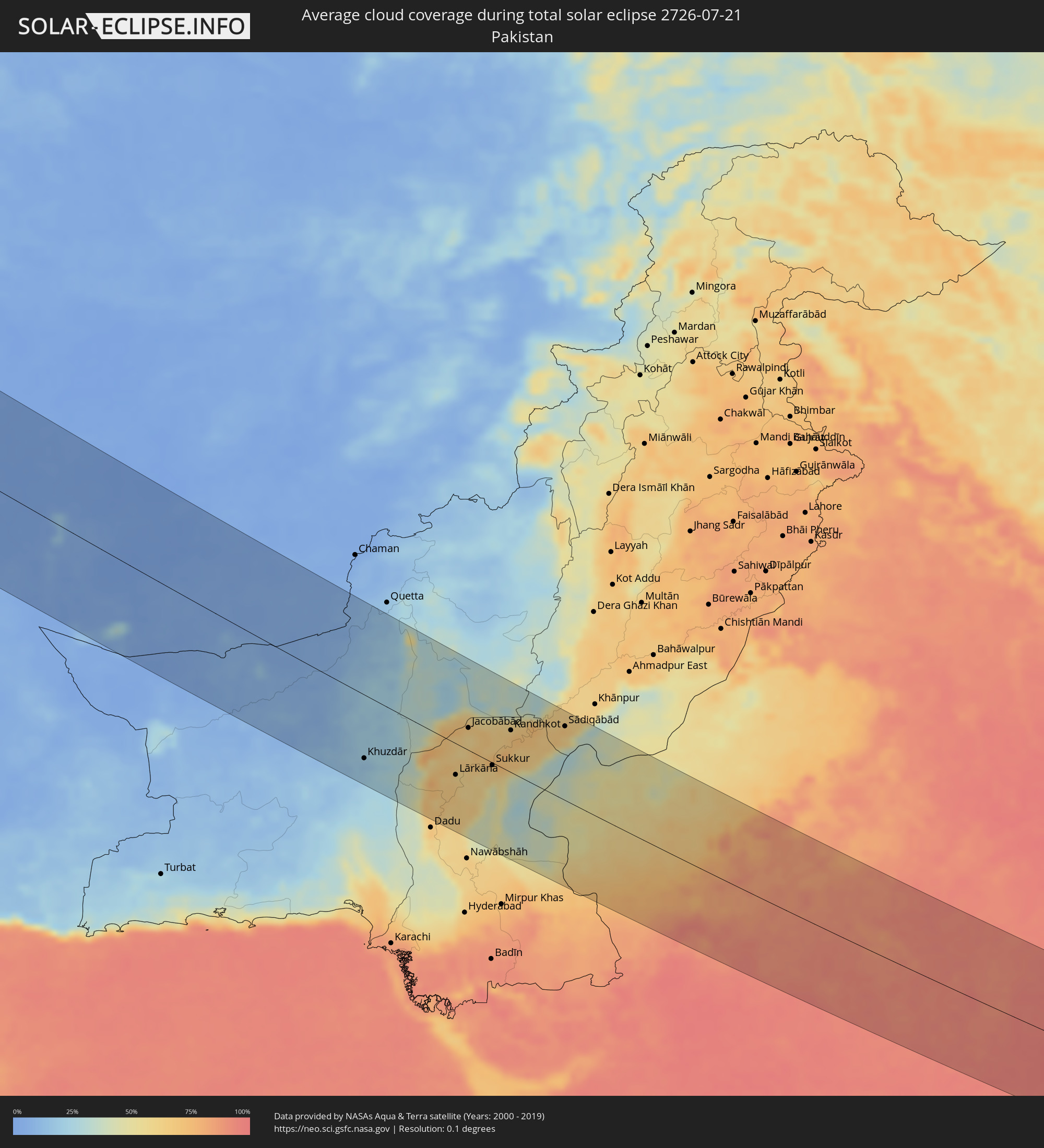 Pakistan
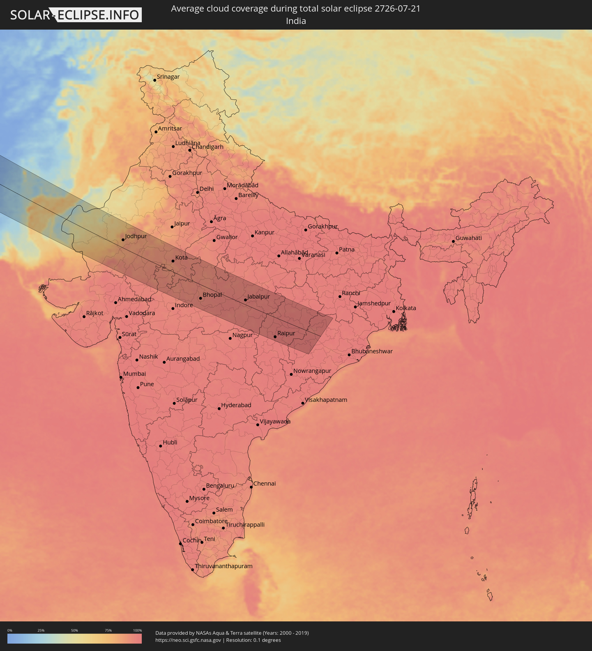 India
India
Cities inside the path of the eclipse
The following table shows all locations with a population of more than 5,000 inside the eclipse path. Cities which have more than 100,000 inhabitants are marked bold. A click at the locations opens a detailed map.
| City | Type | Eclipse duration | Local time of max. eclipse | Distance to central line | Ø Cloud coverage |
|
Plymouth, England
|
total | - | 11:07:17 UTC+00:00 | 22 km | 75% |
|
Bristol, England
|
total | - | 11:09:59 UTC+00:00 | 142 km | 82% |
|
Saint Peter Port, St Peter Port
|
total | - | 11:09:24 UTC+00:00 | 80 km | 63% |
|
Saint Helier, St Helier
|
total | - | 11:10:00 UTC+00:00 | 111 km | 66% |
|
Le Hocq, St Clement
|
total | - | 11:10:03 UTC+00:00 | 113 km | 66% |
|
Bournemouth, England
|
total | - | 11:10:49 UTC+00:00 | 60 km | 71% |
|
Southampton, England
|
total | - | 11:11:35 UTC+00:00 | 81 km | 72% |
|
Portsmouth, England
|
total | - | 11:12:01 UTC+00:00 | 69 km | 70% |
|
Reading, England
|
total | - | 11:12:22 UTC+00:00 | 143 km | 81% |
|
Sutton, England
|
total | - | 11:13:30 UTC+00:00 | 132 km | 83% |
|
Brighton, England
|
total | - | 11:13:29 UTC+00:00 | 74 km | 69% |
|
Le Havre, Normandy
|
total | - | 12:13:35 UTC+01:00 | 73 km | 65% |
|
Bexley, England
|
total | - | 11:14:02 UTC+00:00 | 143 km | 81% |
|
Rouen, Normandy
|
total | - | 12:15:10 UTC+01:00 | 76 km | 76% |
|
Cergy-Pontoise, Île-de-France
|
total | - | 12:16:43 UTC+01:00 | 117 km | 75% |
|
Amiens, Hauts-de-France
|
total | - | 12:17:08 UTC+01:00 | 20 km | 82% |
|
Paris, Île-de-France
|
total | - | 12:17:09 UTC+01:00 | 136 km | 74% |
|
Lille, Hauts-de-France
|
total | - | 12:18:23 UTC+01:00 | 65 km | 81% |
|
Brugge, Flanders
|
total | - | 12:18:40 UTC+01:00 | 130 km | 75% |
|
Gent, Flanders
|
total | - | 12:19:25 UTC+01:00 | 115 km | 79% |
|
Mons, Wallonia
|
total | - | 12:19:46 UTC+01:00 | 50 km | 78% |
|
Reims, Grand-Est
|
total | - | 12:19:55 UTC+01:00 | 83 km | 77% |
|
Hulst, Zeeland
|
total | - | 12:19:56 UTC+01:00 | 143 km | 75% |
|
Brussels, Brussels Capital
|
total | - | 12:20:23 UTC+01:00 | 97 km | 78% |
|
Antwerpen, Flanders
|
total | - | 12:20:28 UTC+01:00 | 138 km | 75% |
|
Charleroi, Wallonia
|
total | - | 12:20:33 UTC+01:00 | 49 km | 78% |
|
Leuven, Flanders
|
total | - | 12:20:56 UTC+01:00 | 103 km | 78% |
|
Namur, Wallonia
|
total | - | 12:21:13 UTC+01:00 | 58 km | 78% |
|
Liège, Wallonia
|
total | - | 12:22:18 UTC+01:00 | 82 km | 76% |
|
Maastricht, Limburg
|
total | - | 12:22:28 UTC+01:00 | 107 km | 74% |
|
Heer, Limburg
|
total | - | 12:22:32 UTC+01:00 | 106 km | 74% |
|
Stein, Limburg
|
total | - | 12:22:35 UTC+01:00 | 121 km | 77% |
|
Elsloo, Limburg
|
total | - | 12:22:35 UTC+01:00 | 118 km | 76% |
|
Born, Limburg
|
total | - | 12:22:39 UTC+01:00 | 128 km | 77% |
|
Differdange, Luxembourg
|
total | - | 12:22:56 UTC+01:00 | 38 km | 74% |
|
Belvaux, Luxembourg
|
total | - | 12:23:00 UTC+01:00 | 39 km | 74% |
|
Esch-sur-Alzette, Luxembourg
|
total | - | 12:23:05 UTC+01:00 | 41 km | 74% |
|
Heerlen, Limburg
|
total | - | 12:22:55 UTC+01:00 | 113 km | 77% |
|
Simpelveld, Limburg
|
total | - | 12:22:56 UTC+01:00 | 107 km | 75% |
|
Vaals, Limburg
|
total | - | 12:23:00 UTC+01:00 | 101 km | 75% |
|
Mamer, Luxembourg
|
total | - | 12:23:08 UTC+01:00 | 26 km | 72% |
|
Bertrange, Luxembourg
|
total | - | 12:23:11 UTC+01:00 | 27 km | 74% |
|
Strassen, Luxembourg
|
total | - | 12:23:13 UTC+01:00 | 26 km | 74% |
|
Ettelbruck, Diekirch
|
total | - | 12:23:14 UTC+01:00 | 1 km | 72% |
|
Luxembourg, Luxembourg
|
total | - | 12:23:19 UTC+01:00 | 26 km | 74% |
|
Diekirch, Diekirch
|
total | - | 12:23:19 UTC+01:00 | 2 km | 73% |
|
Metz, Grand-Est
|
total | - | 12:23:27 UTC+01:00 | 81 km | 73% |
|
Köln, North Rhine-Westphalia
|
total | - | 12:24:25 UTC+01:00 | 127 km | 75% |
|
Bonn, North Rhine-Westphalia
|
total | - | 12:24:41 UTC+01:00 | 106 km | 73% |
|
Strasbourg, Grand-Est
|
total | - | 12:26:10 UTC+01:00 | 124 km | 62% |
|
Wiesbaden, Hesse
|
total | - | 12:26:38 UTC+01:00 | 46 km | 72% |
|
Karlsruhe, Baden-Württemberg
|
total | - | 12:27:10 UTC+01:00 | 70 km | 63% |
|
Mannheim, Baden-Württemberg
|
total | - | 12:27:09 UTC+01:00 | 16 km | 69% |
|
Frankfurt am Main, Hesse
|
total | - | 12:27:19 UTC+01:00 | 54 km | 71% |
|
Stuttgart, Baden-Württemberg
|
total | - | 12:28:31 UTC+01:00 | 86 km | 70% |
|
Nürnberg, Bavaria
|
total | - | 12:31:23 UTC+01:00 | 12 km | 71% |
|
Munich, Bavaria
|
total | - | 12:32:46 UTC+01:00 | 125 km | 57% |
|
Karlovy Vary, Karlovarský
|
total | - | 12:33:54 UTC+01:00 | 122 km | 72% |
|
Salzburg, Salzburg
|
total | - | 12:35:25 UTC+01:00 | 139 km | 54% |
|
Pilsen, Plzeňský
|
total | - | 12:34:56 UTC+01:00 | 78 km | 67% |
|
Wels, Upper Austria
|
total | - | 12:36:52 UTC+01:00 | 83 km | 59% |
|
Kladno, Central Bohemia
|
total | - | 12:35:52 UTC+01:00 | 133 km | 70% |
|
Linz, Upper Austria
|
total | - | 12:37:12 UTC+01:00 | 64 km | 57% |
|
Prague, Praha
|
total | - | 12:36:23 UTC+01:00 | 131 km | 72% |
|
Steyr, Upper Austria
|
total | - | 12:37:35 UTC+01:00 | 90 km | 54% |
|
České Budějovice, Jihočeský
|
total | - | 12:37:07 UTC+01:00 | 12 km | 64% |
|
Jihlava, Vysočina
|
total | - | 12:38:38 UTC+01:00 | 77 km | 70% |
|
Weinzierl bei Krems, Lower Austria
|
total | - | 12:39:17 UTC+01:00 | 30 km | 61% |
|
Sankt Pölten, Lower Austria
|
total | - | 12:39:29 UTC+01:00 | 51 km | 56% |
|
Baden, Lower Austria
|
total | - | 12:40:35 UTC+01:00 | 61 km | 59% |
|
Wiener Neustadt, Lower Austria
|
total | - | 12:40:45 UTC+01:00 | 82 km | 58% |
|
Vienna, Vienna
|
total | - | 12:40:40 UTC+01:00 | 36 km | 61% |
|
Brno, South Moravian
|
total | - | 12:40:22 UTC+01:00 | 75 km | 68% |
|
Szombathely, Vas
|
total | - | 12:41:47 UTC+01:00 | 136 km | 52% |
|
Bratislava, Bratislavský
|
total | - | 12:41:54 UTC+01:00 | 28 km | 57% |
|
Olomouc, Olomoucký
|
total | - | 12:41:06 UTC+01:00 | 130 km | 72% |
|
Trnava, Trnavský
|
total | - | 12:42:30 UTC+01:00 | 6 km | 61% |
|
Győr, Győr-Moson-Sopron
|
total | - | 12:43:07 UTC+01:00 | 67 km | 57% |
|
Zlín, Zlín
|
total | - | 12:42:00 UTC+01:00 | 99 km | 67% |
|
Trenčín, Trenčiansky
|
total | - | 12:42:50 UTC+01:00 | 71 km | 66% |
|
Nitra, Nitriansky
|
total | - | 12:43:21 UTC+01:00 | 9 km | 62% |
|
Székesfehérvár, Fejér
|
total | - | 12:44:46 UTC+01:00 | 103 km | 53% |
|
Žilina, Žilinský
|
total | - | 12:43:40 UTC+01:00 | 120 km | 69% |
|
Martin, Žilinský
|
total | - | 12:44:04 UTC+01:00 | 108 km | 69% |
|
Budapest, Budapest
|
total | - | 12:45:32 UTC+01:00 | 57 km | 56% |
|
Banská Bystrica, Banskobystrický
|
total | - | 12:44:41 UTC+01:00 | 78 km | 63% |
|
Budapest XVII. kerület, Budapest
|
total | - | 12:45:53 UTC+01:00 | 54 km | 58% |
|
Kecskemét, Bács-Kiskun
|
total | - | 12:47:05 UTC+01:00 | 105 km | 50% |
|
Poprad, Prešovský
|
total | - | 12:46:10 UTC+01:00 | 137 km | 75% |
|
Miskolc, Borsod-Abaúj-Zemplén
|
total | - | 12:47:46 UTC+01:00 | 47 km | 62% |
|
Košice, Košický
|
total | - | 12:47:56 UTC+01:00 | 123 km | 65% |
|
Debrecen, Hajdú-Bihar
|
total | - | 12:49:36 UTC+01:00 | 8 km | 54% |
|
Nyíregyháza, Szabolcs-Szatmár-Bereg
|
total | - | 12:49:20 UTC+01:00 | 54 km | 53% |
|
Oradea, Bihor
|
total | - | 13:50:31 UTC+02:00 | 37 km | 48% |
|
Uzhhorod, Zakarpattia
|
total | - | 13:49:35 UTC+02:00 | 138 km | 57% |
|
Mukacheve, Zakarpattia
|
total | - | 13:50:23 UTC+02:00 | 130 km | 55% |
|
Cluj-Napoca, Cluj
|
total | - | 13:53:24 UTC+02:00 | 22 km | 55% |
|
Braşov, Braşov
|
total | - | 13:57:41 UTC+02:00 | 83 km | 63% |
|
Ploieşti, Prahova
|
total | - | 13:59:07 UTC+02:00 | 143 km | 42% |
|
Bacău, Bacău
|
total | - | 13:58:35 UTC+02:00 | 50 km | 37% |
|
Iaşi, Iaşi
|
total | - | 13:58:52 UTC+02:00 | 132 km | 44% |
|
Ungheni, Ungheni
|
total | - | 13:59:05 UTC+02:00 | 142 km | 43% |
|
Brăila, Brăila
|
total | - | 14:01:42 UTC+02:00 | 51 km | 33% |
|
Galaţi, Galaţi
|
total | - | 14:01:34 UTC+02:00 | 30 km | 33% |
|
Cahul, Cahul
|
total | - | 14:01:14 UTC+02:00 | 21 km | 36% |
|
Leova, Leova
|
total | - | 14:00:36 UTC+02:00 | 82 km | 42% |
|
Vulcăneşti, Găgăuzia
|
total | - | 14:01:48 UTC+02:00 | 5 km | 38% |
|
Hînceşti, Hînceşti
|
total | - | 14:00:39 UTC+02:00 | 127 km | 45% |
|
Constanţa, Constanța
|
total | - | 14:04:00 UTC+02:00 | 141 km | 29% |
|
Comrat, Găgăuzia
|
total | - | 14:01:24 UTC+02:00 | 75 km | 42% |
|
Ialoveni, Laloveni
|
total | - | 14:00:47 UTC+02:00 | 145 km | 43% |
|
Ceadîr-Lunga, Găgăuzia
|
total | - | 14:01:56 UTC+02:00 | 57 km | 43% |
|
Izmayil, Odessa
|
total | - | 14:02:50 UTC+02:00 | 16 km | 27% |
|
Căuşeni, Căuşeni
|
total | - | 14:02:02 UTC+02:00 | 133 km | 42% |
|
Bilhorod-Dnistrovs’kyy, Odessa
|
total | - | 14:03:53 UTC+02:00 | 118 km | 36% |
|
Illichivs’k, Odessa
|
total | - | 14:04:09 UTC+02:00 | 139 km | 31% |
|
Yevpatoriya, Republic of Crimea
|
total | - | 15:09:12 UTC+03:00 | 120 km | 33% |
|
Sevastopol, Gorod Sevastopol
|
total | - | 15:10:15 UTC+03:00 | 65 km | 22% |
|
Simferopol, Republic of Crimea
|
total | - | 15:10:30 UTC+03:00 | 122 km | 42% |
|
Yalta, Republic of Crimea
|
total | - | 15:11:12 UTC+03:00 | 79 km | 36% |
|
Ordu, Ordu
|
total | - | 15:20:57 UTC+03:00 | 127 km | 67% |
|
Giresun, Giresun
|
total | - | 15:21:38 UTC+03:00 | 114 km | 79% |
|
Trabzon, Trabzon
|
total | - | 15:23:03 UTC+03:00 | 51 km | 80% |
|
Rize, Rize
|
total | - | 15:23:55 UTC+03:00 | 17 km | 87% |
|
Erzurum, Erzurum
|
total | - | 15:26:26 UTC+03:00 | 93 km | 32% |
|
Batumi, Ajaria
|
total | - | 16:24:10 UTC+04:00 | 89 km | 76% |
|
P’ot’i, Samegrelo and Zemo Svaneti
|
total | - | 16:23:27 UTC+04:00 | 139 km | 59% |
|
Chakvi, Ajaria
|
total | - | 16:24:09 UTC+04:00 | 101 km | 78% |
|
Kobuleti, Ajaria
|
total | - | 16:24:03 UTC+04:00 | 112 km | 81% |
|
Ozurgeti, Guria
|
total | - | 16:24:08 UTC+04:00 | 132 km | 84% |
|
Dioknisi, Ajaria
|
total | - | 16:24:59 UTC+04:00 | 120 km | 61% |
|
Patnos, Ağrı
|
total | - | 15:29:09 UTC+03:00 | 93 km | 23% |
|
Akhaltsikhe, Samtskhe-Javakheti
|
total | - | 16:25:34 UTC+04:00 | 145 km | 52% |
|
Ağrı, Ağrı
|
total | - | 15:28:35 UTC+03:00 | 37 km | 22% |
|
Erciş, Van
|
total | - | 15:29:58 UTC+03:00 | 90 km | 9% |
|
Van, Van
|
total | - | 15:30:49 UTC+03:00 | 140 km | 13% |
|
Akhalk’alak’i
|
total | - | 16:26:26 UTC+04:00 | 144 km | 40% |
|
Ninotsminda, Samtskhe-Javakheti
|
total | - | 16:26:45 UTC+04:00 | 135 km | 46% |
|
Gyumri, Shirak Province
|
total | - | 16:27:44 UTC+04:00 | 101 km | 26% |
|
Armavir, Armavir Province
|
total | - | 16:28:54 UTC+04:00 | 48 km | 13% |
|
Ejmiatsin, Armavir Province
|
total | - | 16:29:08 UTC+04:00 | 60 km | 15% |
|
Step’anavan, Lori Province
|
total | - | 16:27:55 UTC+04:00 | 145 km | 69% |
|
Vanadzor, Lori Province
|
total | - | 16:28:21 UTC+04:00 | 130 km | 68% |
|
Yerevan, Yerevan
|
total | - | 16:29:20 UTC+04:00 | 71 km | 17% |
|
Ararat, Ararat Province
|
total | - | 16:30:03 UTC+04:00 | 45 km | 13% |
|
Hrazdan, Kotayk Province
|
total | - | 16:29:05 UTC+04:00 | 112 km | 37% |
|
Nakhchivan, Nakhichevan
|
total | - | 16:31:41 UTC+04:00 | 17 km | 10% |
|
Culfa, Nakhichevan
|
total | - | 16:32:16 UTC+04:00 | 2 km | 7% |
|
Ordubad, Nakhichevan
|
total | - | 16:32:42 UTC+04:00 | 15 km | 12% |
|
Kerbakhiar, Kalbajar
|
total | - | 16:30:52 UTC+04:00 | 131 km | 64% |
|
Tabriz, East Azerbaijan
|
total | - | 16:04:14 UTC+03:30 | 53 km | 10% |
|
Qafan, Syunik Province
|
total | - | 16:32:35 UTC+04:00 | 60 km | 46% |
|
Xankandi, Xankǝndi
|
total | - | 16:31:57 UTC+04:00 | 134 km | 46% |
|
Fizuli, Füzuli
|
total | - | 16:32:38 UTC+04:00 | 131 km | 40% |
|
Ardabīl, Ardabīl
|
total | - | 16:05:41 UTC+03:30 | 53 km | 24% |
|
Zanjān, Zanjan
|
total | - | 16:08:16 UTC+03:30 | 89 km | 13% |
|
Masally, Masally
|
total | - | 16:34:47 UTC+04:00 | 145 km | 39% |
|
Lankaran, Lənkəran
|
total | - | 16:35:22 UTC+04:00 | 126 km | 30% |
|
Astara, Astara
|
total | - | 16:35:51 UTC+04:00 | 99 km | 33% |
|
Rasht, Gīlān
|
total | - | 16:08:14 UTC+03:30 | 19 km | 49% |
|
Qazvin, Qazvīn
|
total | - | 16:10:05 UTC+03:30 | 58 km | 10% |
|
Karaj, Alborz
|
total | - | 16:11:29 UTC+03:30 | 54 km | 9% |
|
Tehran, Tehrān
|
total | - | 16:12:00 UTC+03:30 | 47 km | 7% |
|
Qarchak, Tehrān
|
total | - | 16:12:30 UTC+03:30 | 66 km | 9% |
|
Sari, Māzandarān
|
total | - | 16:11:48 UTC+03:30 | 112 km | 58% |
|
Mīrābād, Nimroz
|
total | - | 17:24:52 UTC+04:30 | 63 km | 3% |
|
Zaranj, Nimroz
|
total | - | 17:24:10 UTC+04:30 | 11 km | 3% |
|
Farah, Farah
|
total | - | 17:22:18 UTC+04:30 | 138 km | 1% |
|
Rūdbār, Nimroz
|
total | - | 17:25:29 UTC+04:30 | 55 km | 2% |
|
Khāsh, Nimroz
|
total | - | 17:23:41 UTC+04:30 | 88 km | 2% |
|
‘Alāqahdārī Dīshū, Helmand
|
total | - | 17:25:18 UTC+04:30 | 6 km | 4% |
|
Markaz-e Ḩukūmat-e Darwēshān, Helmand
|
total | - | 17:24:36 UTC+04:30 | 116 km | 2% |
|
Khuzdār, Balochistān
|
total | - | 17:59:22 UTC+05:00 | 96 km | 17% |
|
Kambar, Sindh
|
total | - | 17:59:50 UTC+05:00 | 55 km | 64% |
|
Lārkāna, Sindh
|
total | - | 17:59:53 UTC+05:00 | 48 km | 62% |
|
Jacobābād, Sindh
|
total | - | 17:59:01 UTC+05:00 | 34 km | 65% |
|
Shikārpur, Sindh
|
total | - | 17:59:26 UTC+05:00 | 11 km | 72% |
|
Khairpur, Sindh
|
total | - | 17:59:58 UTC+05:00 | 25 km | 60% |
|
Sukkur, Sindh
|
total | - | 17:59:46 UTC+05:00 | 4 km | 62% |
|
Kandhkot, Sindh
|
total | - | 17:59:08 UTC+05:00 | 64 km | 68% |
|
Sādiqābād, Punjab
|
total | - | 17:59:07 UTC+05:00 | 113 km | 69% |
|
Jodhpur, Rajasthan
|
total | - | 18:31:33 UTC+05:30 | 40 km | 81% |
|
Udaipur, Rajasthan
|
total | - | 18:33:24 UTC+05:30 | 100 km | 89% |
|
Ajmer, Rajasthan
|
total | - | 18:31:15 UTC+05:30 | 130 km | 84% |
|
Kota, Rajasthan
|
total | - | 18:32:32 UTC+05:30 | 55 km | 87% |
|
Bhopal, Madhya Pradesh
|
total | - | 18:34:19 UTC+05:30 | 73 km | 92% |
|
Jabalpur, Madhya Pradesh
|
total | - | 18:33:54 UTC+05:30 | 24 km | 95% |
|
Bhilai, Chhattisgarh
|
total | - | 18:35:23 UTC+05:30 | 117 km | 97% |
|
Raipur, Chhattisgarh
|
total | - | 18:35:18 UTC+05:30 | 106 km | 98% |
|
Korba, Chhattisgarh
|
total | - | 18:33:57 UTC+05:30 | 51 km | 98% |