Totale Sonnenfinsternis vom 20.04.2786
| Wochentag: | Sonntag |
| Maximale Dauer der Verfinsterung: | 05m05s |
| Maximale Breite des Finsternispfades: | 240 km |
| Saroszyklus: | 151 |
| Bedeckungsgrad: | 100% |
| Magnitude: | 1.0617 |
| Gamma: | -0.5565 |
Wo kann man die Sonnenfinsternis vom 20.04.2786 sehen?
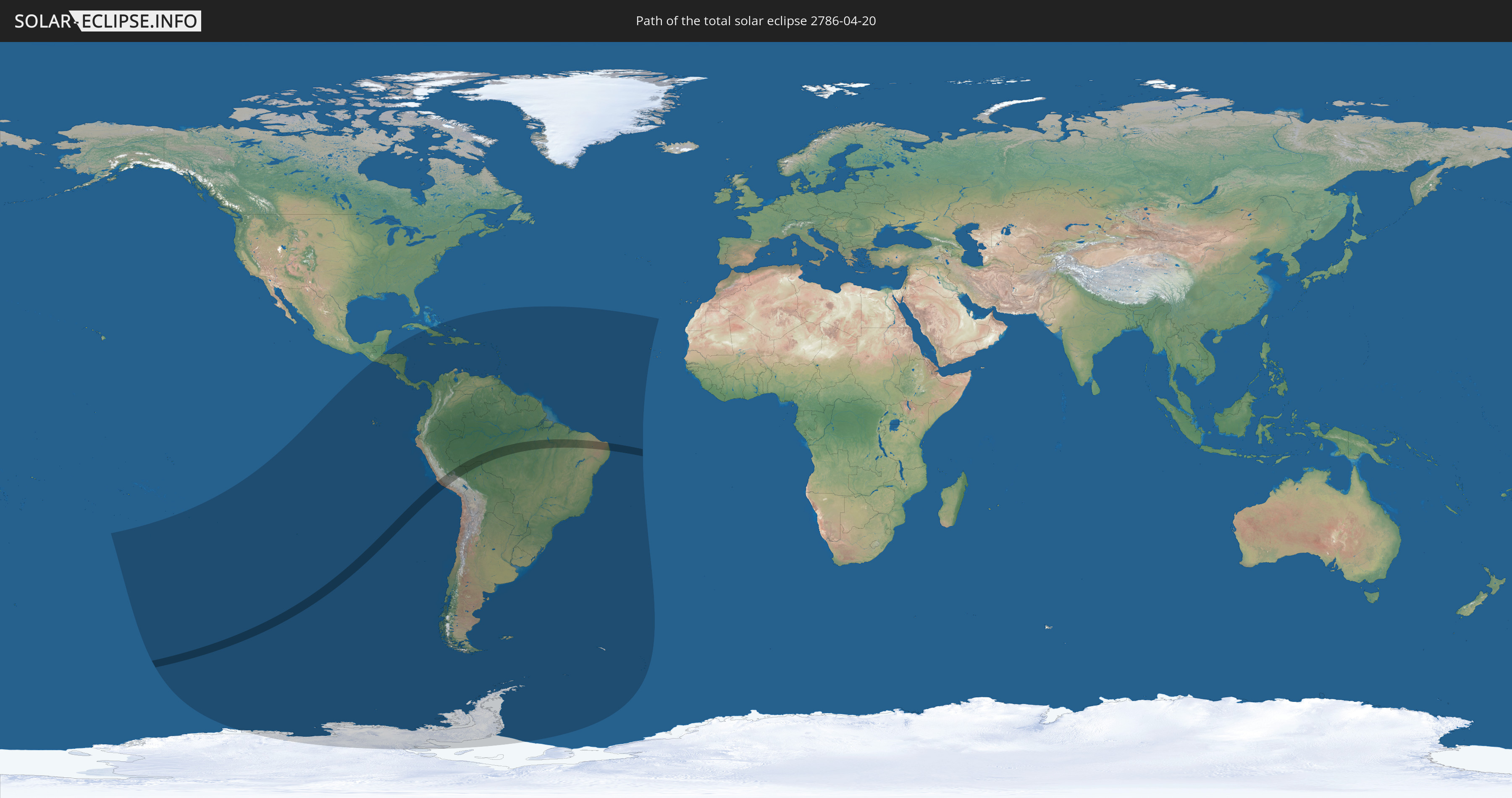
Die Sonnenfinsternis am 20.04.2786 kann man in 52 Ländern als partielle Sonnenfinsternis beobachten.
Der Finsternispfad verläuft durch 3 Länder. Nur in diesen Ländern ist sie als totale Sonnenfinsternis zu sehen.
In den folgenden Ländern ist die Sonnenfinsternis total zu sehen
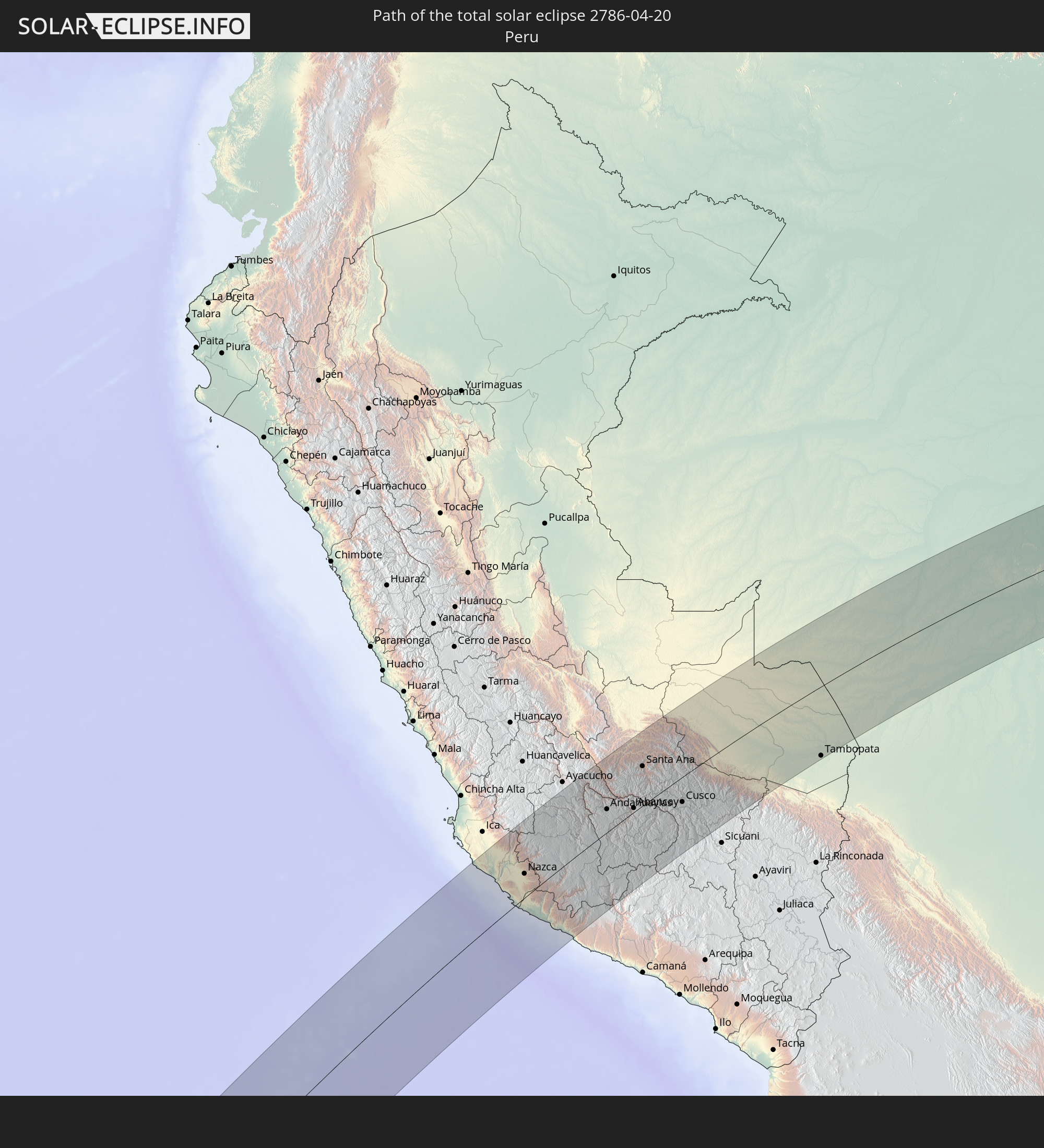 Peru
Peru
 Brasilien
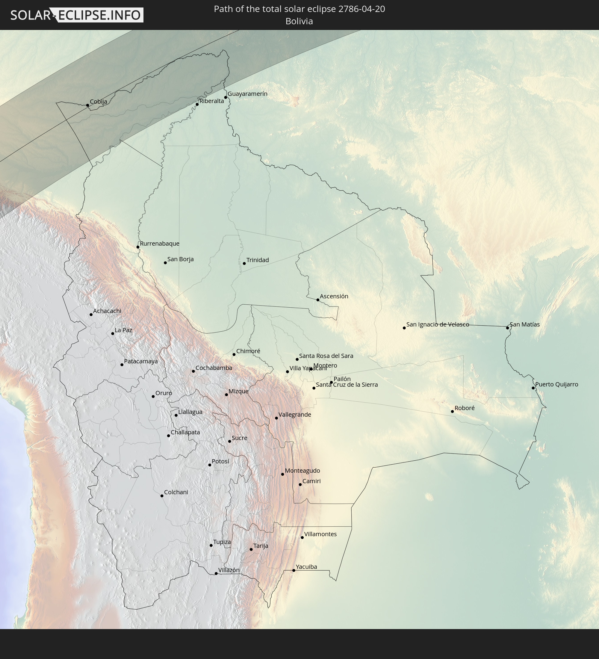 Bolivien
In den folgenden Ländern ist die Sonnenfinsternis partiell zu sehen
 Antarktika
 United States Minor Outlying Islands
 Französisch-Polynesien
 Pitcairninseln
 Chile
Chile
 Guatemala
 Ecuador
 El Salvador
 Honduras
 Belize
 Nicaragua
 Costa Rica
 Kuba
Kuba
 Panama
 Kolumbien
 Kaimaninseln
 Peru
Peru
 Bahamas
 Jamaika
 Haiti
Haiti
 Brasilien
 Argentinien
 Venezuela
 Turks- und Caicosinseln
 Dominikanische Republik
 Aruba
Aruba
 Bolivien
 Puerto Rico
 Amerikanische Jungferninseln
 Britische Jungferninseln
 Anguilla
 Saint-Martin
 Saint-Barthélemy
 St. Kitts und Nevis
 Paraguay
 Antigua und Barbuda
 Montserrat
 Trinidad und Tobago
 Guadeloupe
 Grenada
 Dominica
 St. Vincent und die Grenadinen
 Falklandinseln
 Guyana
 Martinique
 St. Lucia
 Barbados
 Uruguay
 Suriname
 Französisch-Guayana
 Südgeorgien und die Südlichen Sandwichinseln
 Kap Verde
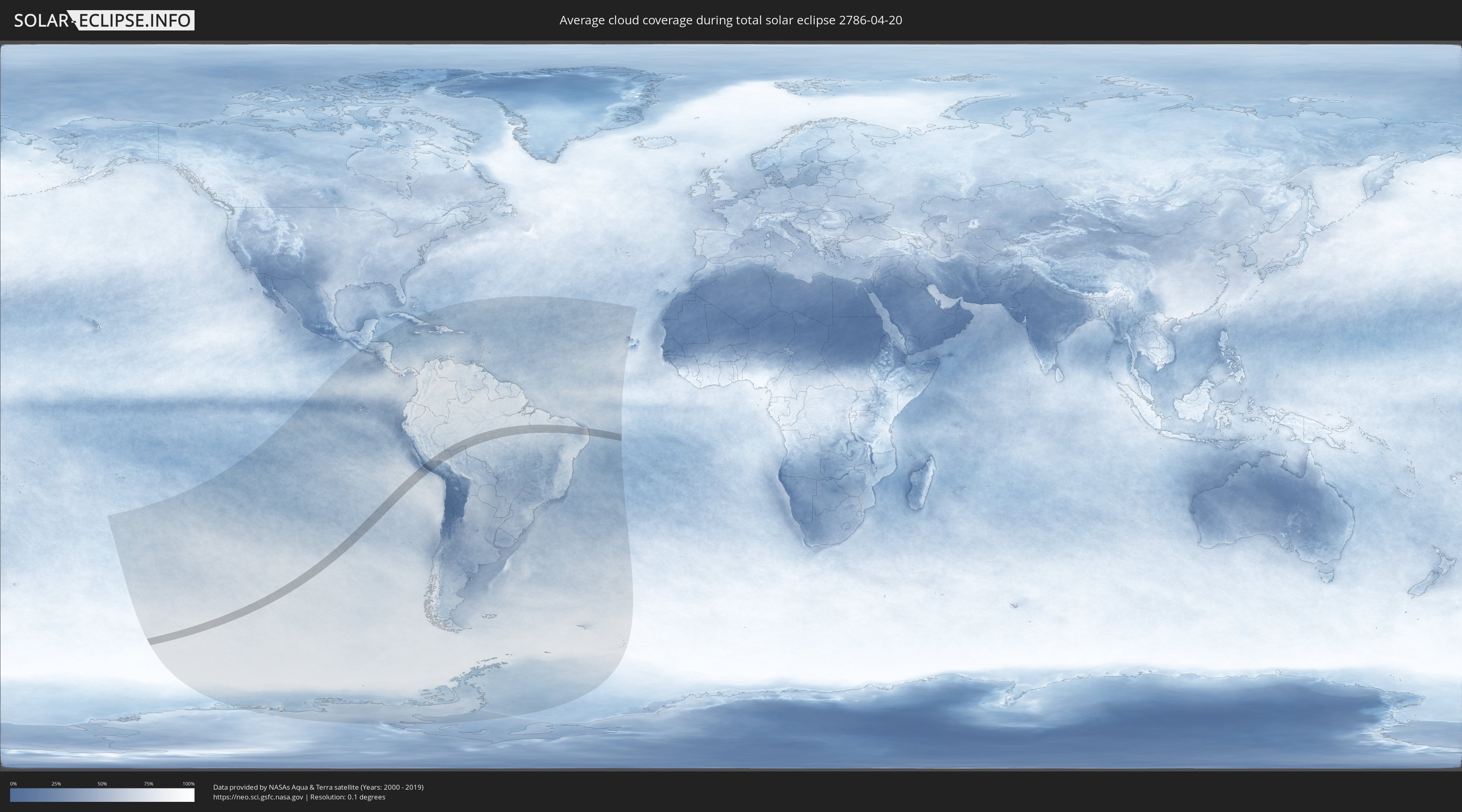
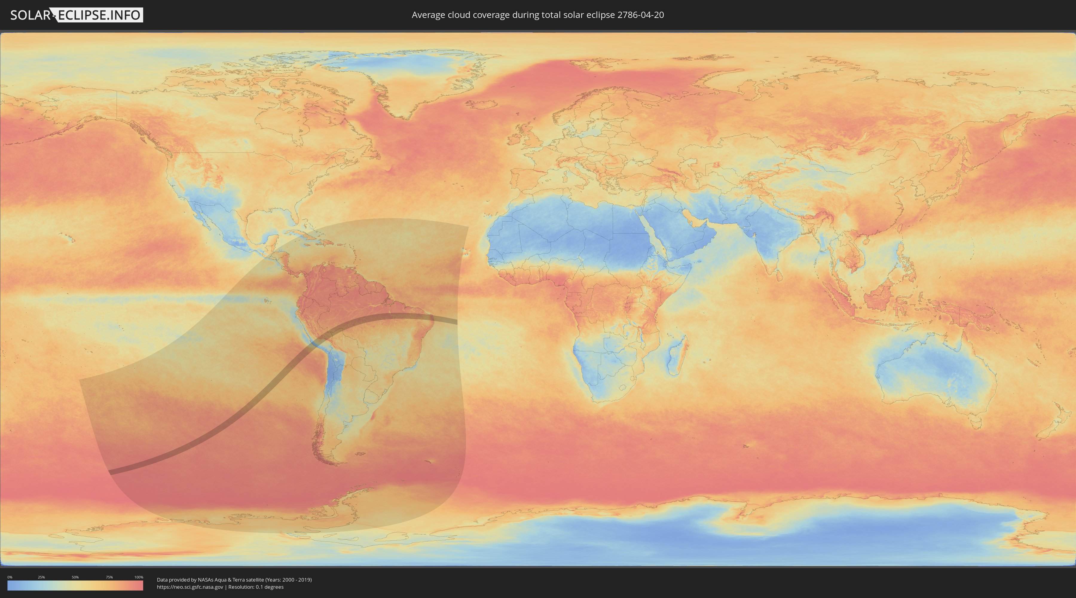
Wie wird das Wetter während der totalen Sonnenfinsternis am 20.04.2786?
Wo ist der beste Ort, um die totale Sonnenfinsternis vom 20.04.2786 zu beobachten?
Die folgenden Karten zeigen die durchschnittliche Bewölkung für den Tag, an dem die totale Sonnenfinsternis
stattfindet. Mit Hilfe der Karten lässt sich der Ort entlang des Finsternispfades eingrenzen,
der die besten Aussichen auf einen klaren wolkenfreien Himmel bietet.
Trotzdem muss man immer lokale Gegenenheiten beachten und sollte sich genau über das Wetter an seinem
gewählten Beobachtungsort informieren.
Die Daten stammen von den beiden NASA-Satelliten
AQUA und TERRA
und wurden über einen Zeitraum von 19 Jahren (2000 - 2019) gemittelt.
Detaillierte Länderkarten
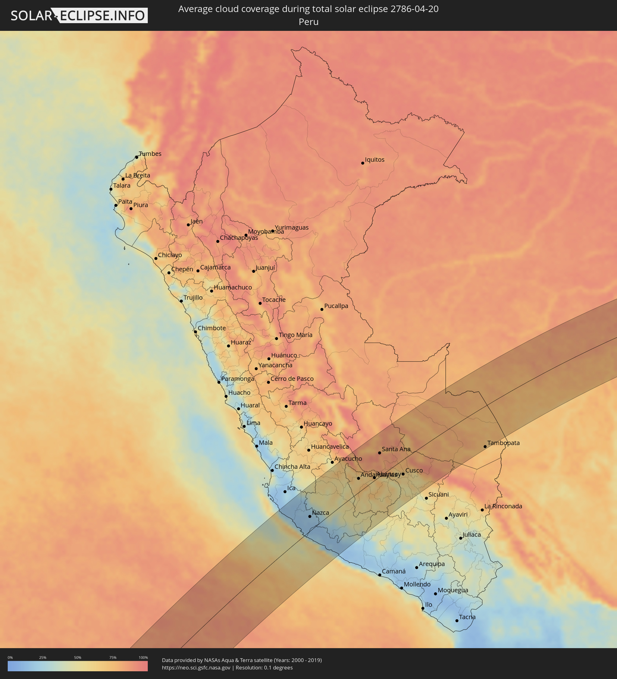 Peru
Peru
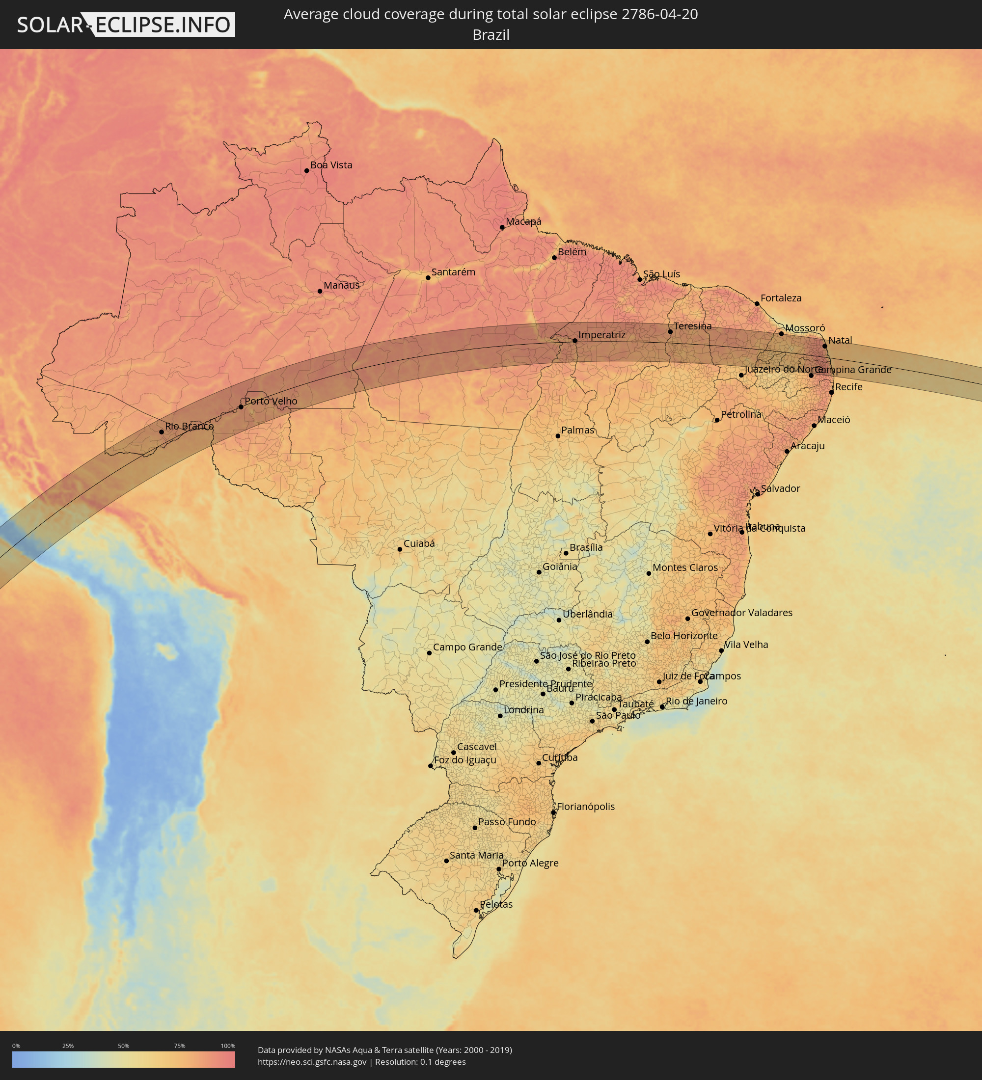 Brasilien
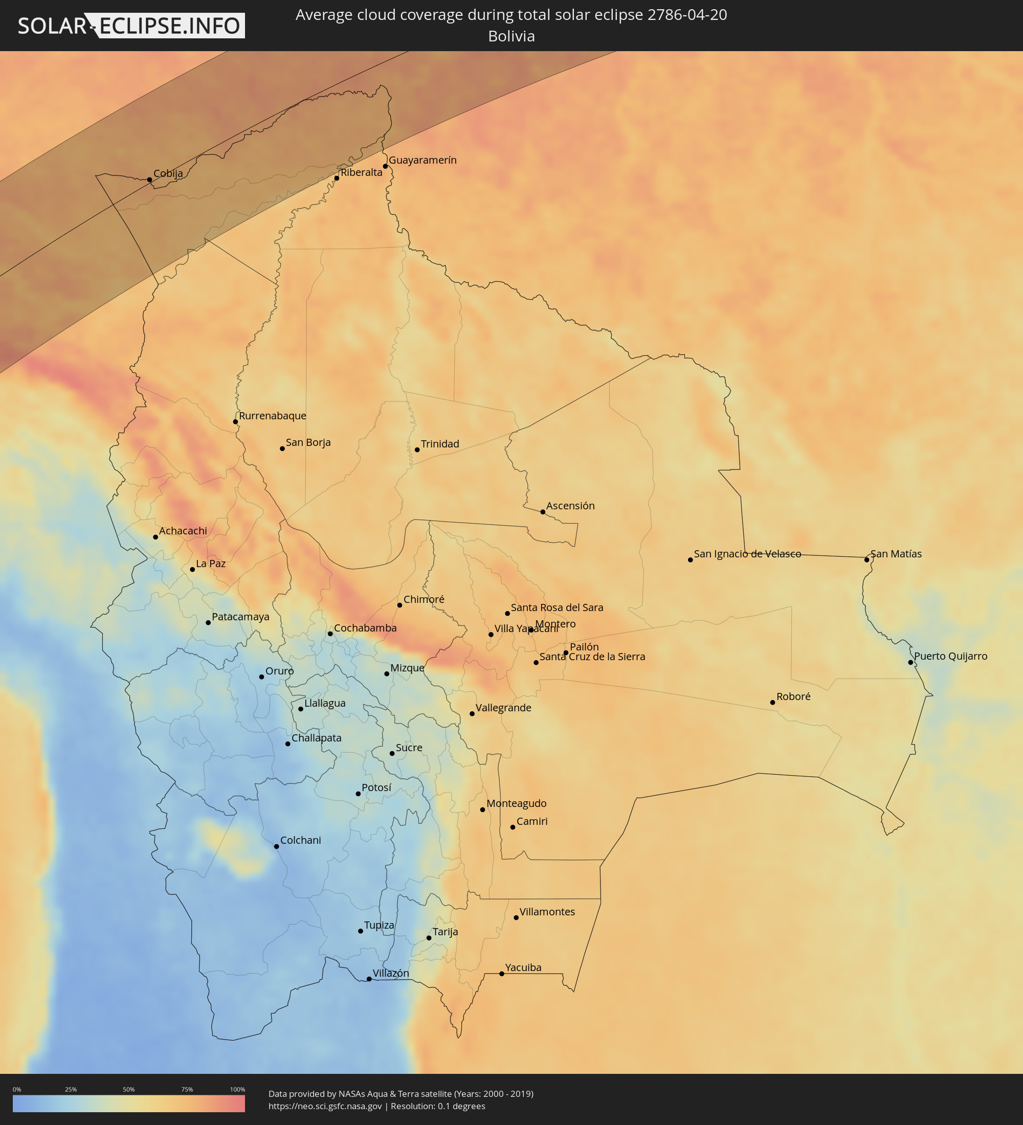 Bolivien
Orte im Finsternispfad
Die nachfolgene Tabelle zeigt Städte und Orte mit mehr als 5.000 Einwohnern, die sich im Finsternispfad befinden. Städte mit mehr als 100.000 Einwohnern sind dick gekennzeichnet. Mit einem Klick auf den Ort öffnet sich eine Detailkarte die die Lage des jeweiligen Ortes zusammen mit dem Verlauf der zentralen Finsternis präsentiert.
| Ort | Typ | Dauer der Verfinsterung | Ortszeit bei maximaler Verfinsterung | Entfernung zur Zentrallinie | Ø Bewölkung |
|
Palpa, Ica
|
total | - | 13:31:19 UTC-05:00 | 80 km | 18% |
|
Minas de Marcona, Ica
|
total | - | 13:30:15 UTC-05:00 | 17 km | 18% |
|
Nazca, Ica
|
total | - | 13:31:17 UTC-05:00 | 38 km | 19% |
|
Puquio, Ayacucho
|
total | - | 13:33:11 UTC-05:00 | 5 km | 37% |
|
Tambo, Ayacucho
|
total | - | 13:33:26 UTC-05:00 | 28 km | 46% |
|
Coracora, Ayacucho
|
total | - | 13:33:19 UTC-05:00 | 58 km | 33% |
|
Talavera, Apurímac
|
total | - | 13:36:30 UTC-05:00 | 40 km | 62% |
|
Andahuaylas, Apurímac
|
total | - | 13:36:35 UTC-05:00 | 37 km | 62% |
|
San Jerónimo, Apurímac
|
total | - | 13:36:38 UTC-05:00 | 36 km | 62% |
|
Abancay, Apurímac
|
total | - | 13:37:39 UTC-05:00 | 7 km | 61% |
|
Santa Ana, Cusco
|
total | - | 13:39:21 UTC-05:00 | 65 km | 82% |
|
Anta, Cusco
|
total | - | 13:39:27 UTC-05:00 | 25 km | 62% |
|
Urubamba, Cusco
|
total | - | 13:39:48 UTC-05:00 | 12 km | 60% |
|
Cusco, Cusco
|
total | - | 13:39:43 UTC-05:00 | 42 km | 58% |
|
Calca, Cusco
|
total | - | 13:40:05 UTC-05:00 | 25 km | 66% |
|
Urcos, Cusco
|
total | - | 13:40:08 UTC-05:00 | 78 km | 54% |
|
Tambopata, Madre de Dios
|
total | - | 13:46:29 UTC-05:00 | 121 km | 74% |
|
Puerto Maldonado, Madre de Dios
|
total | - | 13:46:57 UTC-05:00 | 123 km | 68% |
|
Cobija, Pando
|
total | - | 14:50:29 UTC-04:00 | 3 km | 80% |
|
Rio Branco, Acre
|
total | - | 13:54:08 UTC-05:00 | 55 km | 85% |
|
Porto Velho, Rondônia
|
total | - | 15:03:25 UTC-04:00 | 6 km | 86% |
|
Humaitá, Amazonas
|
total | - | 15:06:54 UTC-04:00 | 89 km | 81% |
|
São Félix do Xingu, Pará
|
total | - | 16:24:47 UTC-03:00 | 90 km | 77% |
|
Itupiranga, Pará
|
total | - | 16:29:44 UTC-03:00 | 54 km | 80% |
|
Marabá, Pará
|
total | - | 16:29:40 UTC-03:00 | 26 km | 87% |
|
Imperatriz, Maranhão
|
total | - | 16:31:13 UTC-03:00 | 3 km | 83% |
|
Porto Franco, Maranhão
|
total | - | 16:30:23 UTC-03:00 | 88 km | 77% |
|
Grajaú, Maranhão
|
total | - | 16:32:13 UTC-03:00 | 32 km | 85% |
|
Barra do Corda, Maranhão
|
total | - | 16:33:25 UTC-03:00 | 4 km | 84% |
|
Tuntum, Maranhão
|
total | - | 16:34:12 UTC-03:00 | 32 km | 82% |
|
Presidente Dutra, Maranhão
|
total | - | 16:34:19 UTC-03:00 | 29 km | 83% |
|
Dom Pedro, Maranhão
|
total | - | 16:34:38 UTC-03:00 | 57 km | 88% |
|
São Domingos do Maranhão, Maranhão
|
total | - | 16:34:06 UTC-03:00 | 3 km | 83% |
|
Colinas, Maranhão
|
total | - | 16:33:43 UTC-03:00 | 52 km | 81% |
|
Buriti Bravo, Maranhão
|
total | - | 16:34:17 UTC-03:00 | 30 km | 79% |
|
São João dos Patos, Maranhão
|
total | - | 16:33:41 UTC-03:00 | 103 km | 77% |
|
Caxias, Maranhão
|
total | - | 16:35:43 UTC-03:00 | 81 km | 86% |
|
Estreito, Maranhão
|
total | - | 16:34:50 UTC-03:00 | 22 km | 81% |
|
Teresina, Piauí
|
total | - | 16:35:55 UTC-03:00 | 58 km | 84% |
|
Demerval Lobão, Piauí
|
total | - | 16:35:45 UTC-03:00 | 28 km | 78% |
|
José de Freitas, Piauí
|
total | - | 16:36:27 UTC-03:00 | 96 km | 82% |
|
Altos, Piauí
|
total | - | 16:36:15 UTC-03:00 | 65 km | 80% |
|
Campo Maior, Piauí
|
total | - | 16:36:41 UTC-03:00 | 90 km | 82% |
|
Valença do Piauí, Piauí
|
total | - | 16:35:22 UTC-03:00 | 83 km | 77% |
|
Parambu, Ceará
|
total | - | 16:36:20 UTC-03:00 | 53 km | 81% |
|
Crateús, Ceará
|
total | - | 16:37:25 UTC-03:00 | 62 km | 83% |
|
Várzea Alegre, Ceará
|
total | - | 16:37:26 UTC-03:00 | 45 km | 83% |
|
São João dos Inhamuns, Ceará
|
total | - | 16:36:51 UTC-03:00 | 26 km | 83% |
|
Boa Viagem, Ceará
|
total | - | 16:38:06 UTC-03:00 | 76 km | 86% |
|
Pedra Branca, Ceará
|
total | - | 16:37:47 UTC-03:00 | 39 km | 86% |
|
Mombaça, Ceará
|
total | - | 16:37:33 UTC-03:00 | 8 km | 82% |
|
Jucás, Ceará
|
total | - | 16:36:49 UTC-03:00 | 78 km | 78% |
|
Acopiara, Ceará
|
total | - | 16:37:19 UTC-03:00 | 29 km | 80% |
|
Senador Pompeu, Ceará
|
total | - | 16:37:52 UTC-03:00 | 28 km | 83% |
|
Iguatu, Ceará
|
total | - | 16:37:09 UTC-03:00 | 57 km | 76% |
|
Quixeramobim, Ceará
|
total | - | 16:38:19 UTC-03:00 | 72 km | 84% |
|
Lavras da Mangabeira, Ceará
|
total | - | 16:36:57 UTC-03:00 | 97 km | 78% |
|
Orós, Ceará
|
total | - | 16:37:30 UTC-03:00 | 40 km | 75% |
|
Icó, Ceará
|
total | - | 16:37:23 UTC-03:00 | 57 km | 72% |
|
Jaguaribe, Ceará
|
total | - | 16:38:03 UTC-03:00 | 2 km | 78% |
|
Morada Nova, Ceará
|
total | - | 16:38:58 UTC-03:00 | 92 km | 79% |
|
Sousa, Paraíba
|
total | - | 16:37:25 UTC-03:00 | 90 km | 66% |
|
Limoeiro do Norte, Ceará
|
total | - | 16:39:05 UTC-03:00 | 90 km | 82% |
|
Pombal, Paraíba
|
total | - | 16:37:40 UTC-03:00 | 86 km | 70% |
|
Apodi, Rio Grande do Norte
|
total | - | 16:38:46 UTC-03:00 | 37 km | 76% |
|
São Bento, Paraíba
|
total | - | 16:38:11 UTC-03:00 | 31 km | 69% |
|
Mossoró, Rio Grande do Norte
|
total | - | 16:39:29 UTC-03:00 | 95 km | 78% |
|
Caicó, Rio Grande do Norte
|
total | - | 16:38:23 UTC-03:00 | 43 km | 67% |
|
Açu, Rio Grande do Norte
|
total | - | 16:39:21 UTC-03:00 | 57 km | 67% |
|
Parelhas, Rio Grande do Norte
|
total | - | 16:38:24 UTC-03:00 | 62 km | 68% |
|
Currais Novos, Rio Grande do Norte
|
total | - | 16:38:53 UTC-03:00 | 13 km | 75% |
|
Santa Cruz, Rio Grande do Norte
|
total | - | 16:39:11 UTC-03:00 | 3 km | 83% |
|
Esperança, Paraíba
|
total | - | 16:38:29 UTC-03:00 | 89 km | 82% |
|
João Câmara, Rio Grande do Norte
|
total | - | 16:39:56 UTC-03:00 | 76 km | 88% |
|
Belém, Paraíba
|
total | - | 16:38:59 UTC-03:00 | 47 km | 89% |
|
Guarabira, Paraíba
|
total | - | 16:38:50 UTC-03:00 | 64 km | 89% |
|
Nova Cruz, Rio Grande do Norte
|
total | - | 16:39:14 UTC-03:00 | 22 km | 91% |
|
Ceará Mirim, Rio Grande do Norte
|
total | - | 16:40:03 UTC-03:00 | 71 km | 87% |
|
Macaíba, Rio Grande do Norte
|
total | - | 16:39:52 UTC-03:00 | 48 km | 89% |
|
Mari, Paraíba
|
total | - | 16:38:43 UTC-03:00 | 85 km | 90% |
|
São José de Mipibu, Rio Grande do Norte
|
total | - | 16:39:43 UTC-03:00 | 25 km | 78% |
|
Natal, Rio Grande do Norte
|
total | - | 16:40:00 UTC-03:00 | 57 km | 77% |
|
Canguaretama, Rio Grande do Norte
|
total | - | 16:39:29 UTC-03:00 | 7 km | 85% |
|
Mamanguape, Paraíba
|
total | - | 16:39:02 UTC-03:00 | 57 km | 88% |
|
João Pessoa, Paraíba
|
total | - | 16:38:53 UTC-03:00 | 84 km | 83% |
|
Cabedelo, Paraíba
|
total | - | 16:39:02 UTC-03:00 | 68 km | 73% |