Total solar eclipse of 04/20/2786
| Day of week: | Sunday |
| Maximum duration of eclipse: | 05m05s |
| Maximum width of eclipse path: | 240 km |
| Saros cycle: | 151 |
| Coverage: | 100% |
| Magnitude: | 1.0617 |
| Gamma: | -0.5565 |
Wo kann man die Sonnenfinsternis vom 04/20/2786 sehen?
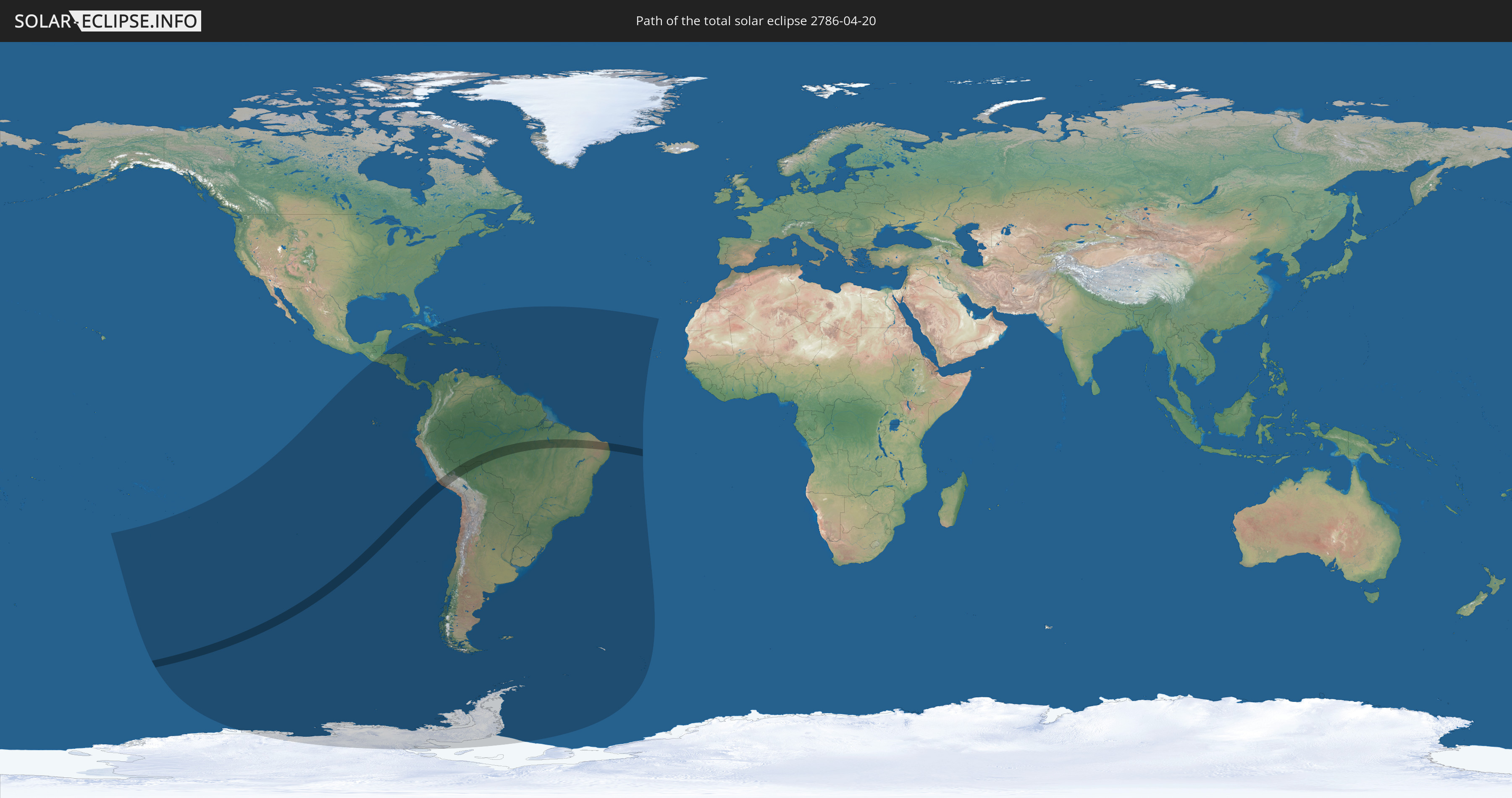
Die Sonnenfinsternis am 04/20/2786 kann man in 52 Ländern als partielle Sonnenfinsternis beobachten.
Der Finsternispfad verläuft durch 3 Länder. Nur in diesen Ländern ist sie als total Sonnenfinsternis zu sehen.
In den folgenden Ländern ist die Sonnenfinsternis total zu sehen
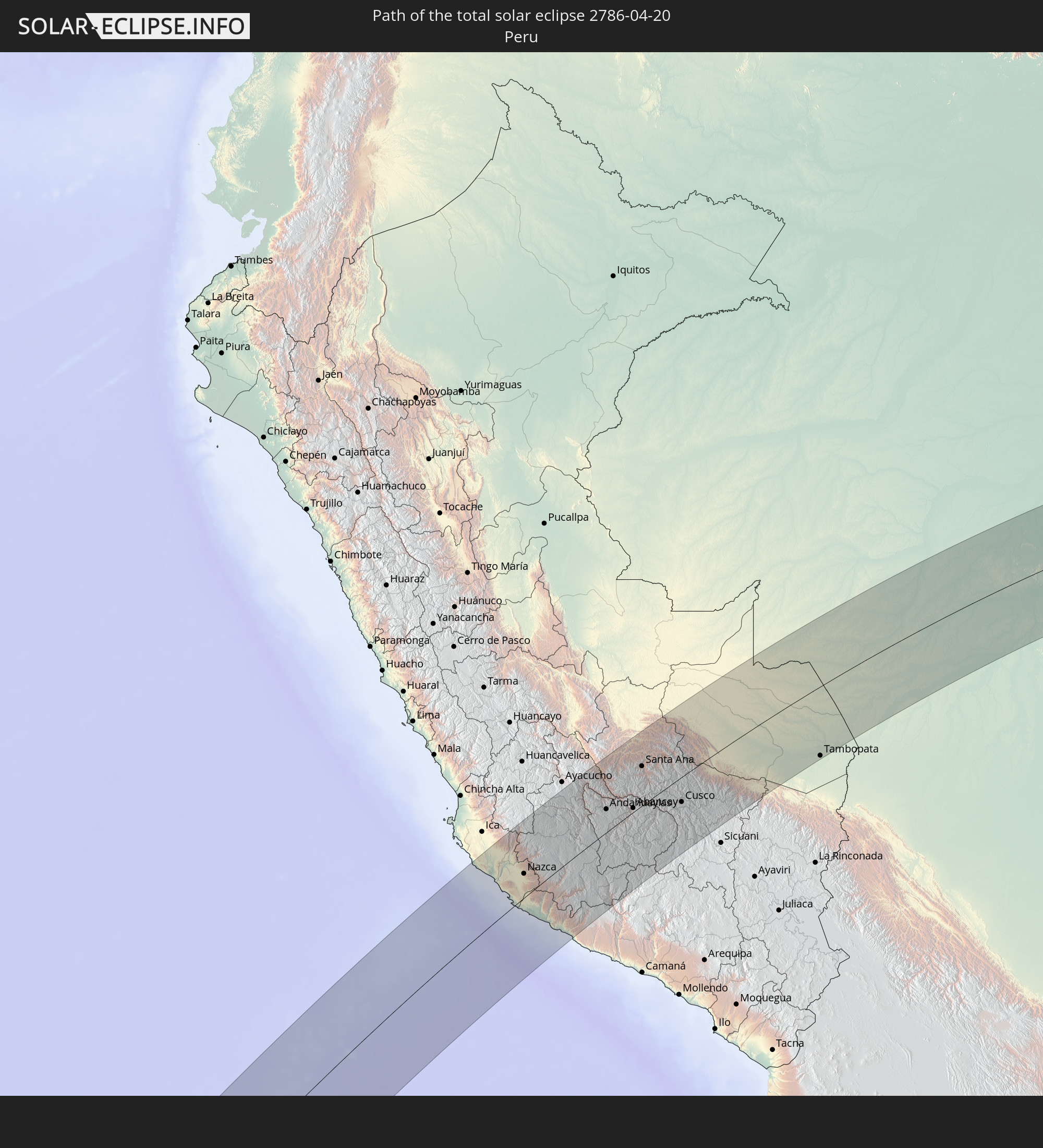 Peru
Peru
 Brazil
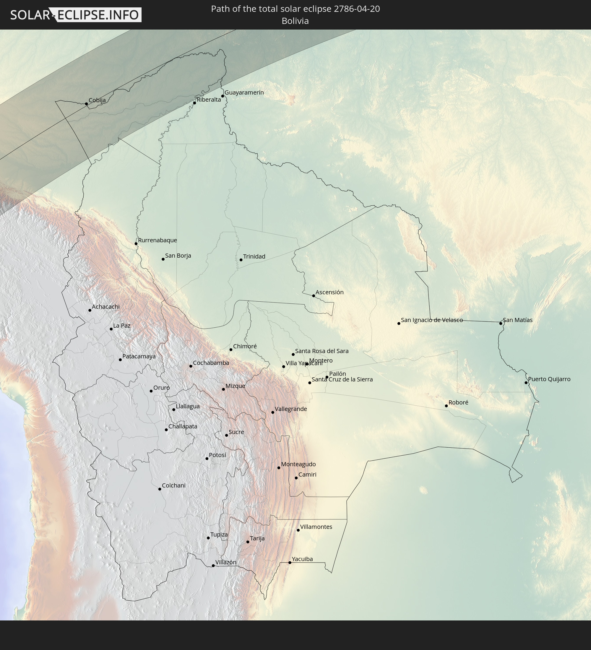 Bolivia
In den folgenden Ländern ist die Sonnenfinsternis partiell zu sehen
 Antarctica
 United States Minor Outlying Islands
 French Polynesia
 Pitcairn Islands
 Chile
Chile
 Guatemala
 Ecuador
 El Salvador
 Honduras
 Belize
 Nicaragua
 Costa Rica
 Cuba
Cuba
 Panama
 Colombia
 Cayman Islands
 Peru
Peru
 The Bahamas
 Jamaica
 Haiti
Haiti
 Brazil
 Argentina
 Venezuela
 Turks and Caicos Islands
 Dominican Republic
 Aruba
Aruba
 Bolivia
 Puerto Rico
 United States Virgin Islands
 British Virgin Islands
 Anguilla
 Collectivity of Saint Martin
 Saint Barthélemy
 Saint Kitts and Nevis
 Paraguay
 Antigua and Barbuda
 Montserrat
 Trinidad and Tobago
 Guadeloupe
 Grenada
 Dominica
 Saint Vincent and the Grenadines
 Falkland Islands
 Guyana
 Martinique
 Saint Lucia
 Barbados
 Uruguay
 Suriname
 French Guiana
 South Georgia and the South Sandwich Islands
 Cabo Verde
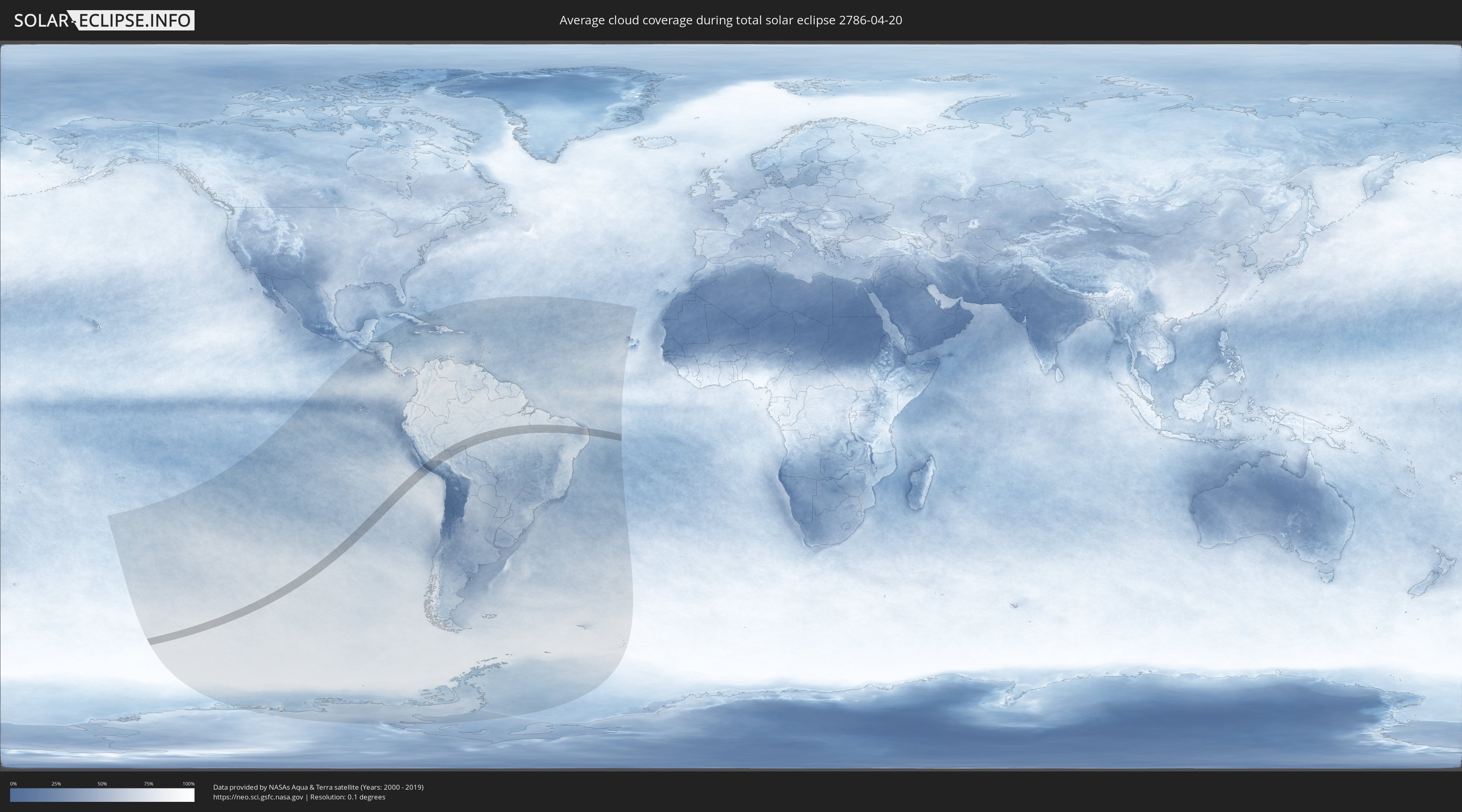
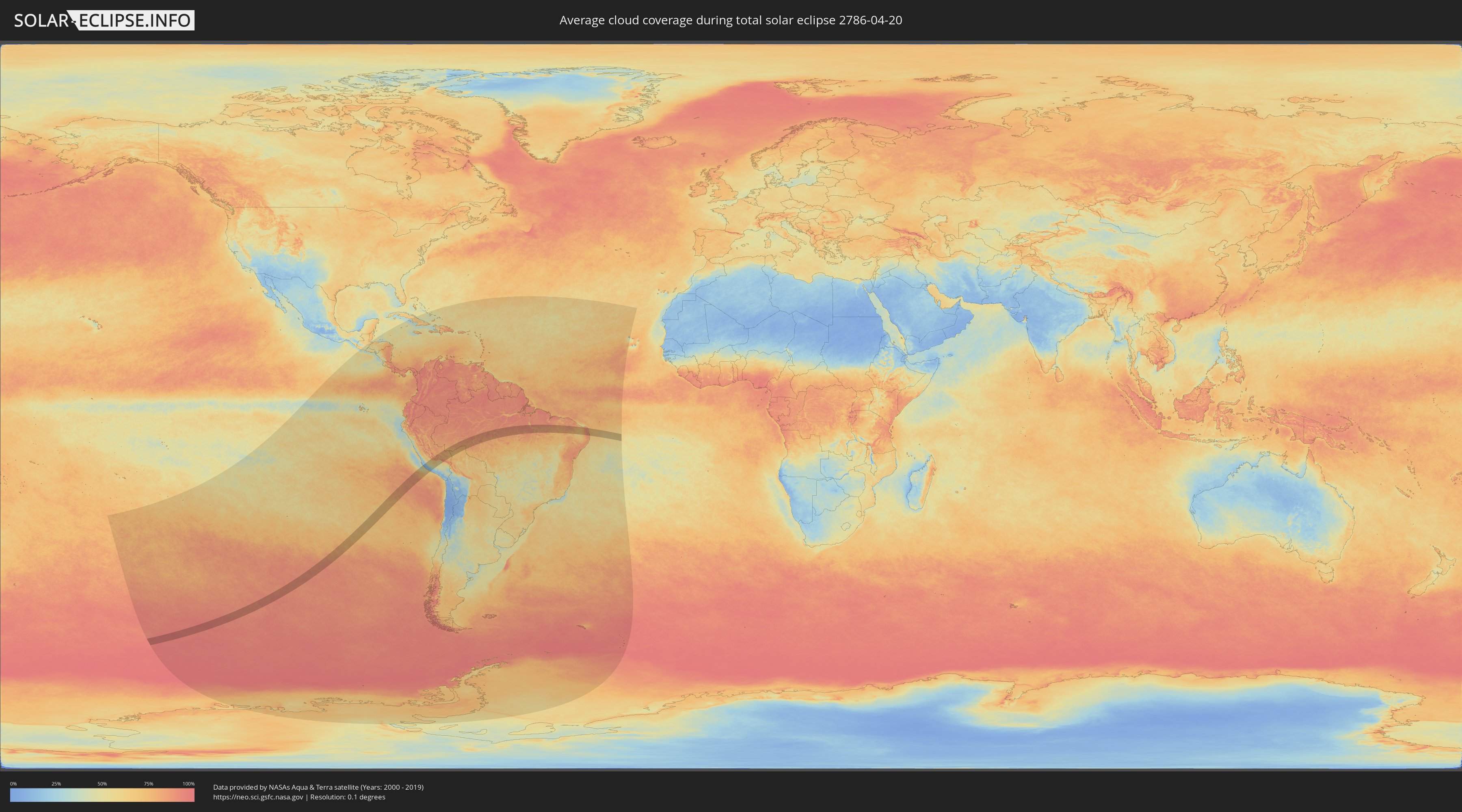
How will be the weather during the total solar eclipse on 04/20/2786?
Where is the best place to see the total solar eclipse of 04/20/2786?
The following maps show the average cloud coverage for the day of the total solar eclipse.
With the help of these maps, it is possible to find the place along the eclipse path, which has the best
chance of a cloudless sky.
Nevertheless, you should consider local circumstances and inform about the weather of your chosen
observation site.
The data is provided by NASAs satellites
AQUA and TERRA.
The cloud maps are averaged over a period of 19 years (2000 - 2019).
Detailed country maps
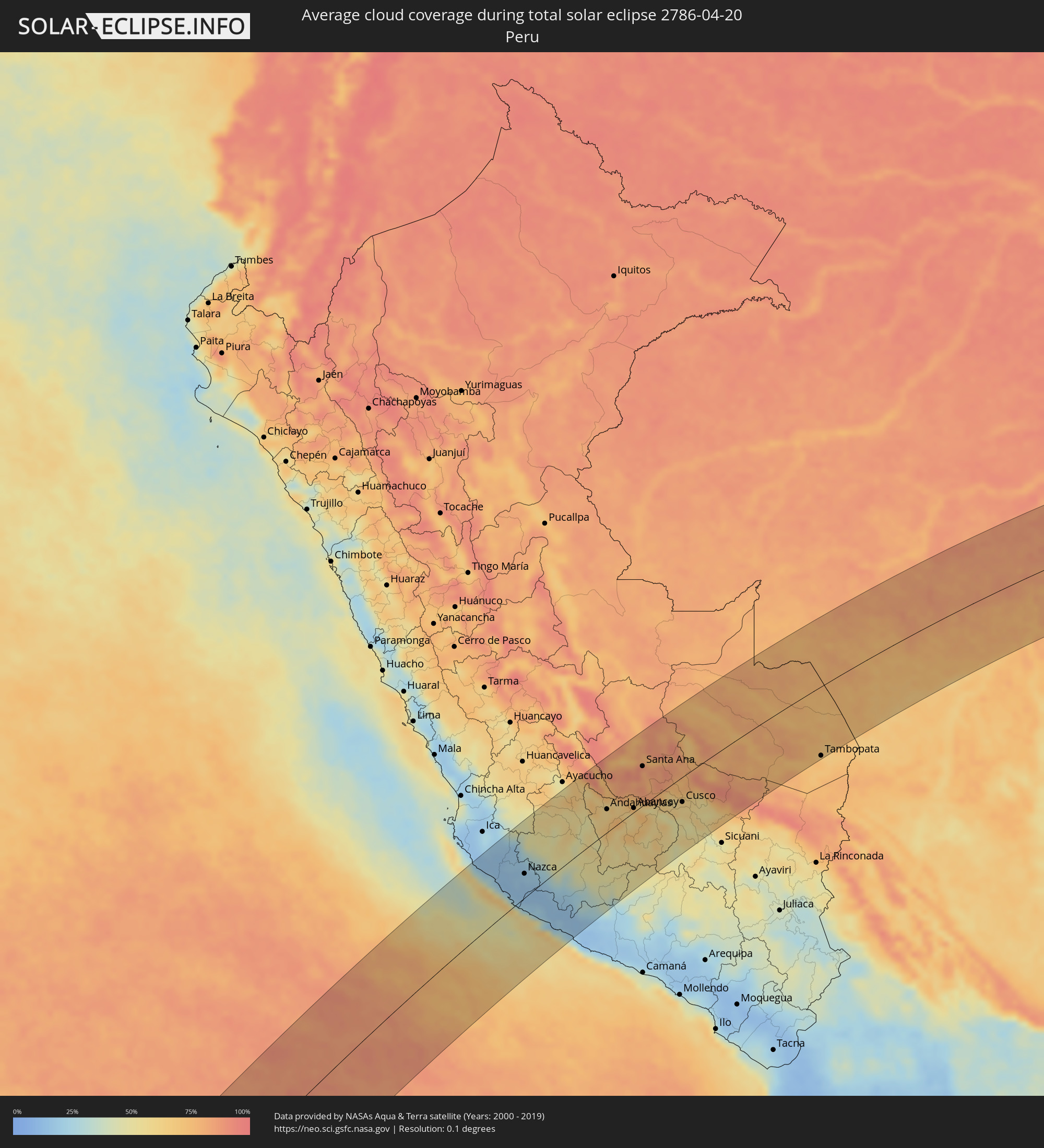 Peru
Peru
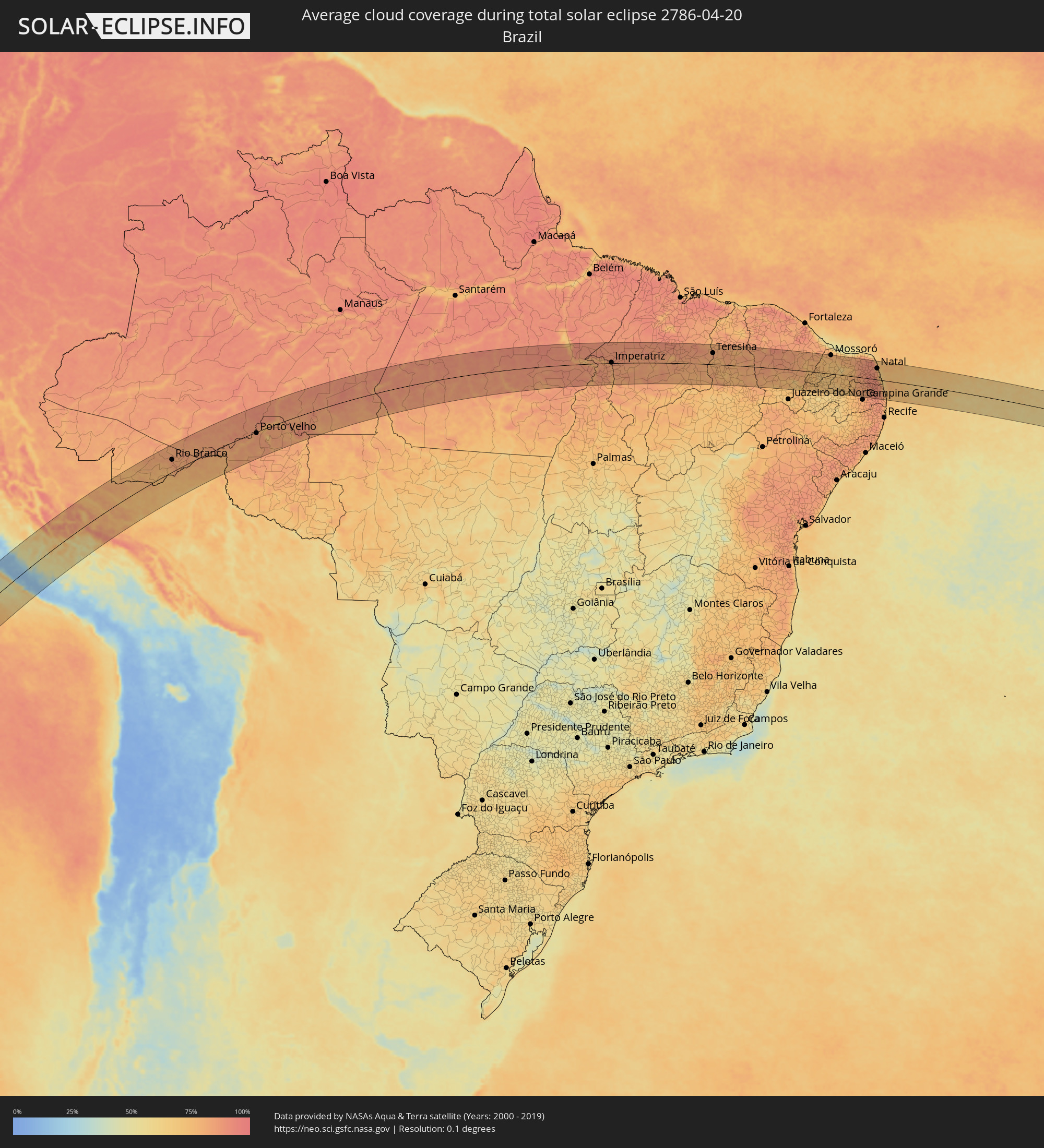 Brazil
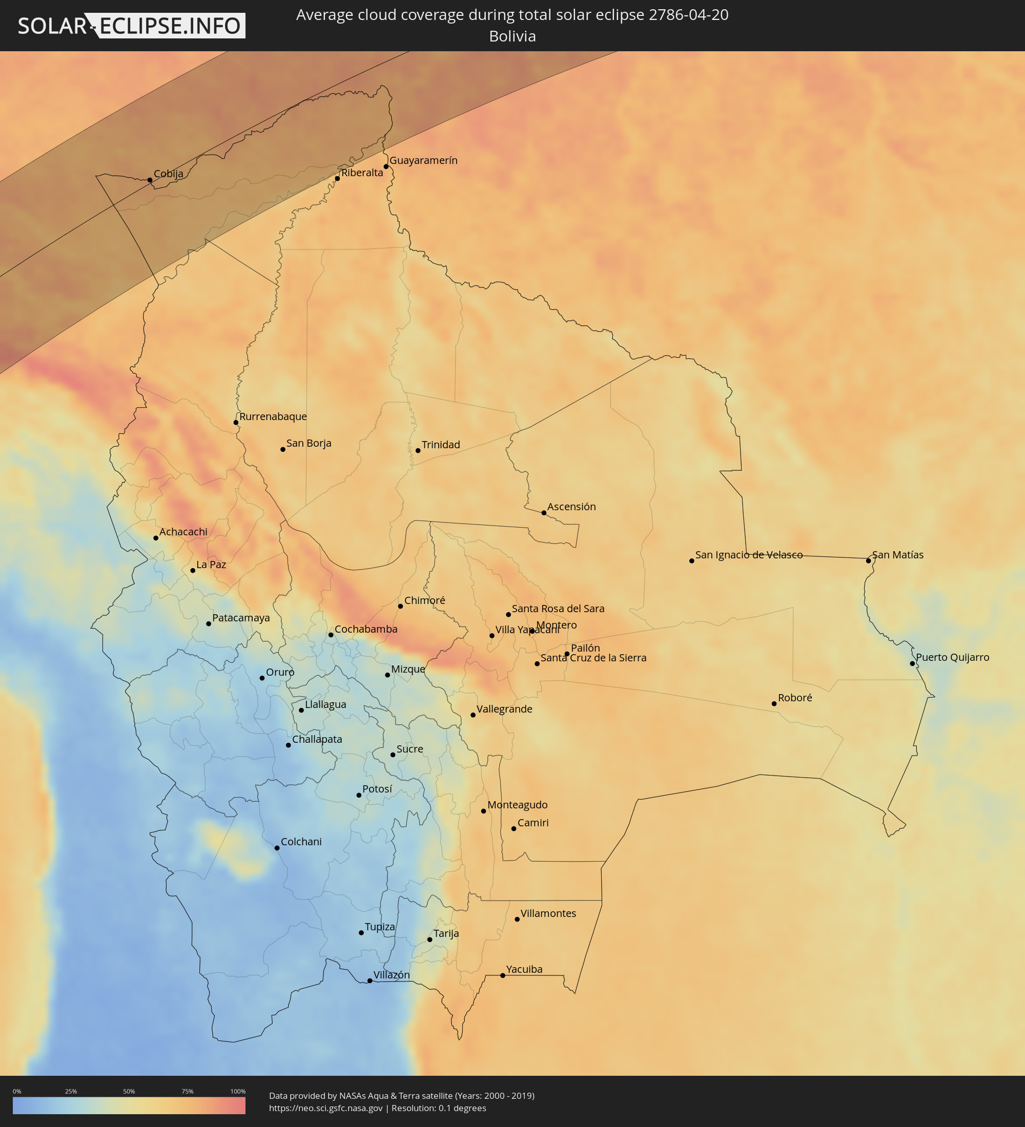 Bolivia
Cities inside the path of the eclipse
The following table shows all locations with a population of more than 5,000 inside the eclipse path. Cities which have more than 100,000 inhabitants are marked bold. A click at the locations opens a detailed map.
| City | Type | Eclipse duration | Local time of max. eclipse | Distance to central line | Ø Cloud coverage |
|
Palpa, Ica
|
total | - | 13:31:19 UTC-05:00 | 80 km | 18% |
|
Minas de Marcona, Ica
|
total | - | 13:30:15 UTC-05:00 | 17 km | 18% |
|
Nazca, Ica
|
total | - | 13:31:17 UTC-05:00 | 38 km | 19% |
|
Puquio, Ayacucho
|
total | - | 13:33:11 UTC-05:00 | 5 km | 37% |
|
Tambo, Ayacucho
|
total | - | 13:33:26 UTC-05:00 | 28 km | 46% |
|
Coracora, Ayacucho
|
total | - | 13:33:19 UTC-05:00 | 58 km | 33% |
|
Talavera, Apurímac
|
total | - | 13:36:30 UTC-05:00 | 40 km | 62% |
|
Andahuaylas, Apurímac
|
total | - | 13:36:35 UTC-05:00 | 37 km | 62% |
|
San Jerónimo, Apurímac
|
total | - | 13:36:38 UTC-05:00 | 36 km | 62% |
|
Abancay, Apurímac
|
total | - | 13:37:39 UTC-05:00 | 7 km | 61% |
|
Santa Ana, Cusco
|
total | - | 13:39:21 UTC-05:00 | 65 km | 82% |
|
Anta, Cusco
|
total | - | 13:39:27 UTC-05:00 | 25 km | 62% |
|
Urubamba, Cusco
|
total | - | 13:39:48 UTC-05:00 | 12 km | 60% |
|
Cusco, Cusco
|
total | - | 13:39:43 UTC-05:00 | 42 km | 58% |
|
Calca, Cusco
|
total | - | 13:40:05 UTC-05:00 | 25 km | 66% |
|
Urcos, Cusco
|
total | - | 13:40:08 UTC-05:00 | 78 km | 54% |
|
Tambopata, Madre de Dios
|
total | - | 13:46:29 UTC-05:00 | 121 km | 74% |
|
Puerto Maldonado, Madre de Dios
|
total | - | 13:46:57 UTC-05:00 | 123 km | 68% |
|
Cobija, Pando
|
total | - | 14:50:29 UTC-04:00 | 3 km | 80% |
|
Rio Branco, Acre
|
total | - | 13:54:08 UTC-05:00 | 55 km | 85% |
|
Porto Velho, Rondônia
|
total | - | 15:03:25 UTC-04:00 | 6 km | 86% |
|
Humaitá, Amazonas
|
total | - | 15:06:54 UTC-04:00 | 89 km | 81% |
|
São Félix do Xingu, Pará
|
total | - | 16:24:47 UTC-03:00 | 90 km | 77% |
|
Itupiranga, Pará
|
total | - | 16:29:44 UTC-03:00 | 54 km | 80% |
|
Marabá, Pará
|
total | - | 16:29:40 UTC-03:00 | 26 km | 87% |
|
Imperatriz, Maranhão
|
total | - | 16:31:13 UTC-03:00 | 3 km | 83% |
|
Porto Franco, Maranhão
|
total | - | 16:30:23 UTC-03:00 | 88 km | 77% |
|
Grajaú, Maranhão
|
total | - | 16:32:13 UTC-03:00 | 32 km | 85% |
|
Barra do Corda, Maranhão
|
total | - | 16:33:25 UTC-03:00 | 4 km | 84% |
|
Tuntum, Maranhão
|
total | - | 16:34:12 UTC-03:00 | 32 km | 82% |
|
Presidente Dutra, Maranhão
|
total | - | 16:34:19 UTC-03:00 | 29 km | 83% |
|
Dom Pedro, Maranhão
|
total | - | 16:34:38 UTC-03:00 | 57 km | 88% |
|
São Domingos do Maranhão, Maranhão
|
total | - | 16:34:06 UTC-03:00 | 3 km | 83% |
|
Colinas, Maranhão
|
total | - | 16:33:43 UTC-03:00 | 52 km | 81% |
|
Buriti Bravo, Maranhão
|
total | - | 16:34:17 UTC-03:00 | 30 km | 79% |
|
São João dos Patos, Maranhão
|
total | - | 16:33:41 UTC-03:00 | 103 km | 77% |
|
Caxias, Maranhão
|
total | - | 16:35:43 UTC-03:00 | 81 km | 86% |
|
Estreito, Maranhão
|
total | - | 16:34:50 UTC-03:00 | 22 km | 81% |
|
Teresina, Piauí
|
total | - | 16:35:55 UTC-03:00 | 58 km | 84% |
|
Demerval Lobão, Piauí
|
total | - | 16:35:45 UTC-03:00 | 28 km | 78% |
|
José de Freitas, Piauí
|
total | - | 16:36:27 UTC-03:00 | 96 km | 82% |
|
Altos, Piauí
|
total | - | 16:36:15 UTC-03:00 | 65 km | 80% |
|
Campo Maior, Piauí
|
total | - | 16:36:41 UTC-03:00 | 90 km | 82% |
|
Valença do Piauí, Piauí
|
total | - | 16:35:22 UTC-03:00 | 83 km | 77% |
|
Parambu, Ceará
|
total | - | 16:36:20 UTC-03:00 | 53 km | 81% |
|
Crateús, Ceará
|
total | - | 16:37:25 UTC-03:00 | 62 km | 83% |
|
Várzea Alegre, Ceará
|
total | - | 16:37:26 UTC-03:00 | 45 km | 83% |
|
São João dos Inhamuns, Ceará
|
total | - | 16:36:51 UTC-03:00 | 26 km | 83% |
|
Boa Viagem, Ceará
|
total | - | 16:38:06 UTC-03:00 | 76 km | 86% |
|
Pedra Branca, Ceará
|
total | - | 16:37:47 UTC-03:00 | 39 km | 86% |
|
Mombaça, Ceará
|
total | - | 16:37:33 UTC-03:00 | 8 km | 82% |
|
Jucás, Ceará
|
total | - | 16:36:49 UTC-03:00 | 78 km | 78% |
|
Acopiara, Ceará
|
total | - | 16:37:19 UTC-03:00 | 29 km | 80% |
|
Senador Pompeu, Ceará
|
total | - | 16:37:52 UTC-03:00 | 28 km | 83% |
|
Iguatu, Ceará
|
total | - | 16:37:09 UTC-03:00 | 57 km | 76% |
|
Quixeramobim, Ceará
|
total | - | 16:38:19 UTC-03:00 | 72 km | 84% |
|
Lavras da Mangabeira, Ceará
|
total | - | 16:36:57 UTC-03:00 | 97 km | 78% |
|
Orós, Ceará
|
total | - | 16:37:30 UTC-03:00 | 40 km | 75% |
|
Icó, Ceará
|
total | - | 16:37:23 UTC-03:00 | 57 km | 72% |
|
Jaguaribe, Ceará
|
total | - | 16:38:03 UTC-03:00 | 2 km | 78% |
|
Morada Nova, Ceará
|
total | - | 16:38:58 UTC-03:00 | 92 km | 79% |
|
Sousa, Paraíba
|
total | - | 16:37:25 UTC-03:00 | 90 km | 66% |
|
Limoeiro do Norte, Ceará
|
total | - | 16:39:05 UTC-03:00 | 90 km | 82% |
|
Pombal, Paraíba
|
total | - | 16:37:40 UTC-03:00 | 86 km | 70% |
|
Apodi, Rio Grande do Norte
|
total | - | 16:38:46 UTC-03:00 | 37 km | 76% |
|
São Bento, Paraíba
|
total | - | 16:38:11 UTC-03:00 | 31 km | 69% |
|
Mossoró, Rio Grande do Norte
|
total | - | 16:39:29 UTC-03:00 | 95 km | 78% |
|
Caicó, Rio Grande do Norte
|
total | - | 16:38:23 UTC-03:00 | 43 km | 67% |
|
Açu, Rio Grande do Norte
|
total | - | 16:39:21 UTC-03:00 | 57 km | 67% |
|
Parelhas, Rio Grande do Norte
|
total | - | 16:38:24 UTC-03:00 | 62 km | 68% |
|
Currais Novos, Rio Grande do Norte
|
total | - | 16:38:53 UTC-03:00 | 13 km | 75% |
|
Santa Cruz, Rio Grande do Norte
|
total | - | 16:39:11 UTC-03:00 | 3 km | 83% |
|
Esperança, Paraíba
|
total | - | 16:38:29 UTC-03:00 | 89 km | 82% |
|
João Câmara, Rio Grande do Norte
|
total | - | 16:39:56 UTC-03:00 | 76 km | 88% |
|
Belém, Paraíba
|
total | - | 16:38:59 UTC-03:00 | 47 km | 89% |
|
Guarabira, Paraíba
|
total | - | 16:38:50 UTC-03:00 | 64 km | 89% |
|
Nova Cruz, Rio Grande do Norte
|
total | - | 16:39:14 UTC-03:00 | 22 km | 91% |
|
Ceará Mirim, Rio Grande do Norte
|
total | - | 16:40:03 UTC-03:00 | 71 km | 87% |
|
Macaíba, Rio Grande do Norte
|
total | - | 16:39:52 UTC-03:00 | 48 km | 89% |
|
Mari, Paraíba
|
total | - | 16:38:43 UTC-03:00 | 85 km | 90% |
|
São José de Mipibu, Rio Grande do Norte
|
total | - | 16:39:43 UTC-03:00 | 25 km | 78% |
|
Natal, Rio Grande do Norte
|
total | - | 16:40:00 UTC-03:00 | 57 km | 77% |
|
Canguaretama, Rio Grande do Norte
|
total | - | 16:39:29 UTC-03:00 | 7 km | 85% |
|
Mamanguape, Paraíba
|
total | - | 16:39:02 UTC-03:00 | 57 km | 88% |
|
João Pessoa, Paraíba
|
total | - | 16:38:53 UTC-03:00 | 84 km | 83% |
|
Cabedelo, Paraíba
|
total | - | 16:39:02 UTC-03:00 | 68 km | 73% |