Totale Sonnenfinsternis vom 03.07.2866
| Wochentag: | Samstag |
| Maximale Dauer der Verfinsterung: | 04m59s |
| Maximale Breite des Finsternispfades: | 209 km |
| Saroszyklus: | 160 |
| Bedeckungsgrad: | 100% |
| Magnitude: | 1.061 |
| Gamma: | 0.2785 |
Wo kann man die Sonnenfinsternis vom 03.07.2866 sehen?
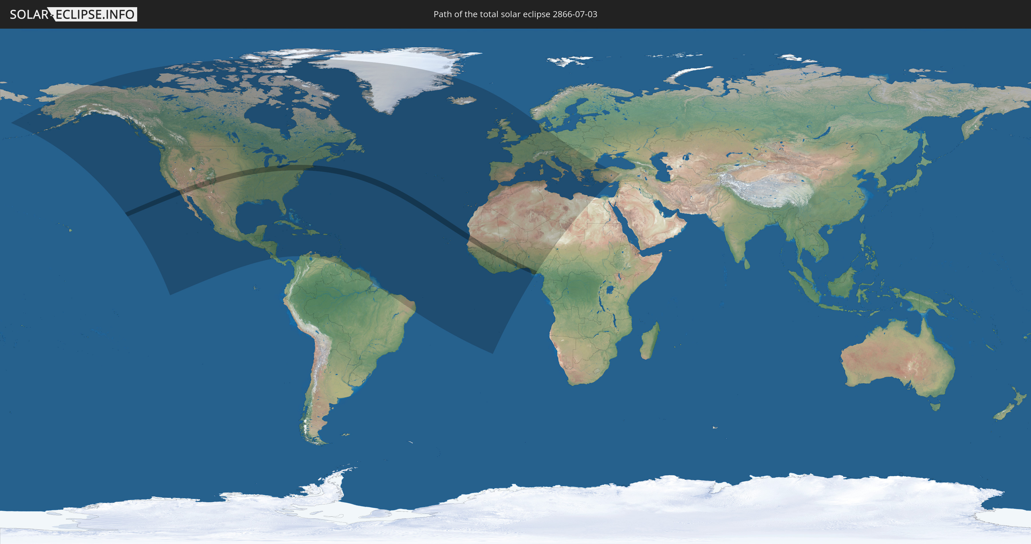
Die Sonnenfinsternis am 03.07.2866 kann man in 108 Ländern als partielle Sonnenfinsternis beobachten.
Der Finsternispfad verläuft durch 13 Länder. Nur in diesen Ländern ist sie als totale Sonnenfinsternis zu sehen.
In den folgenden Ländern ist die Sonnenfinsternis total zu sehen
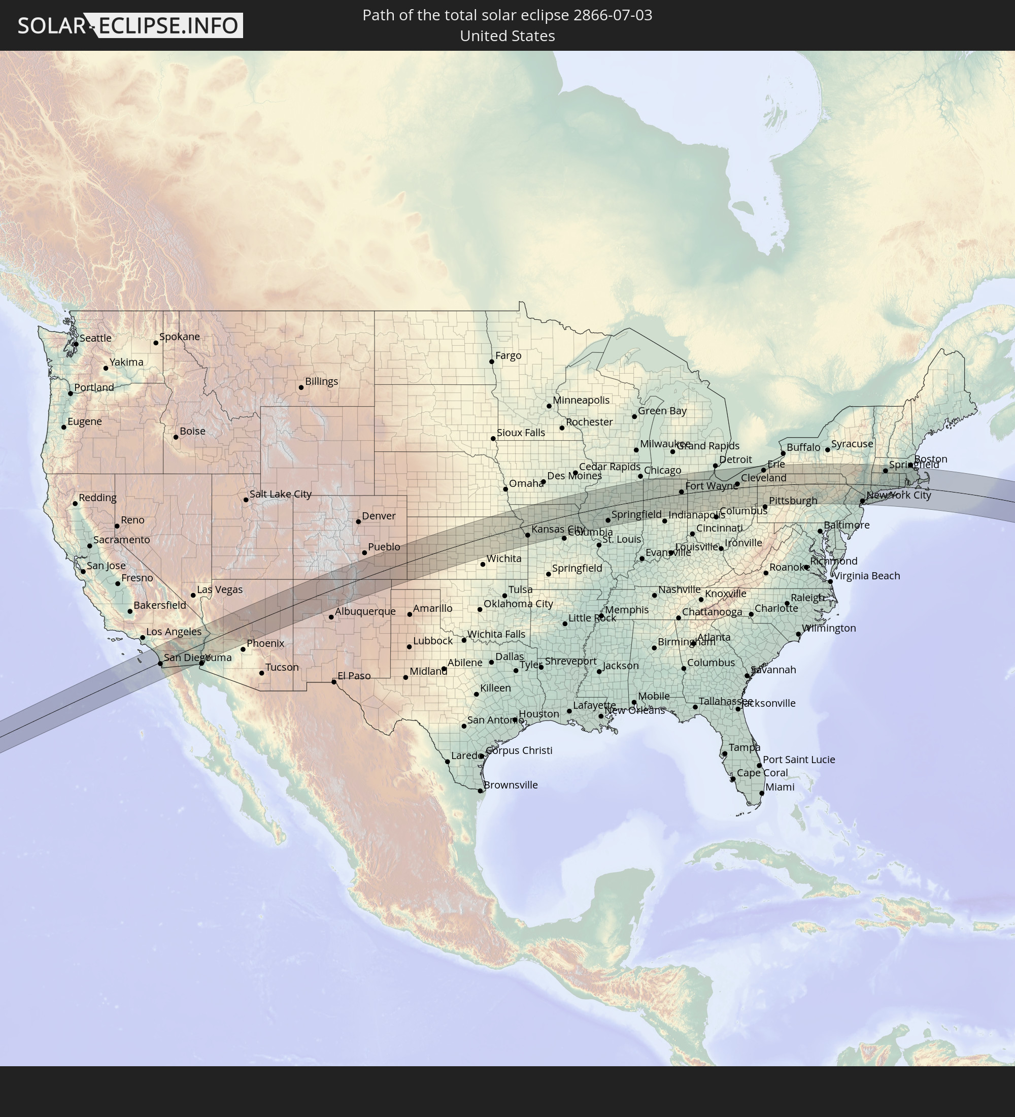 Vereinigte Staaten
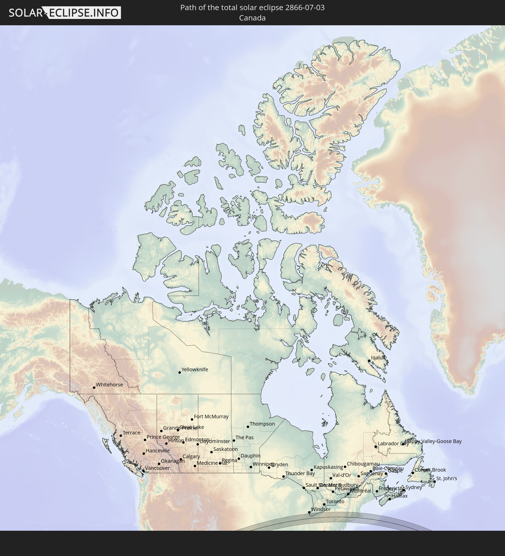 Kanada
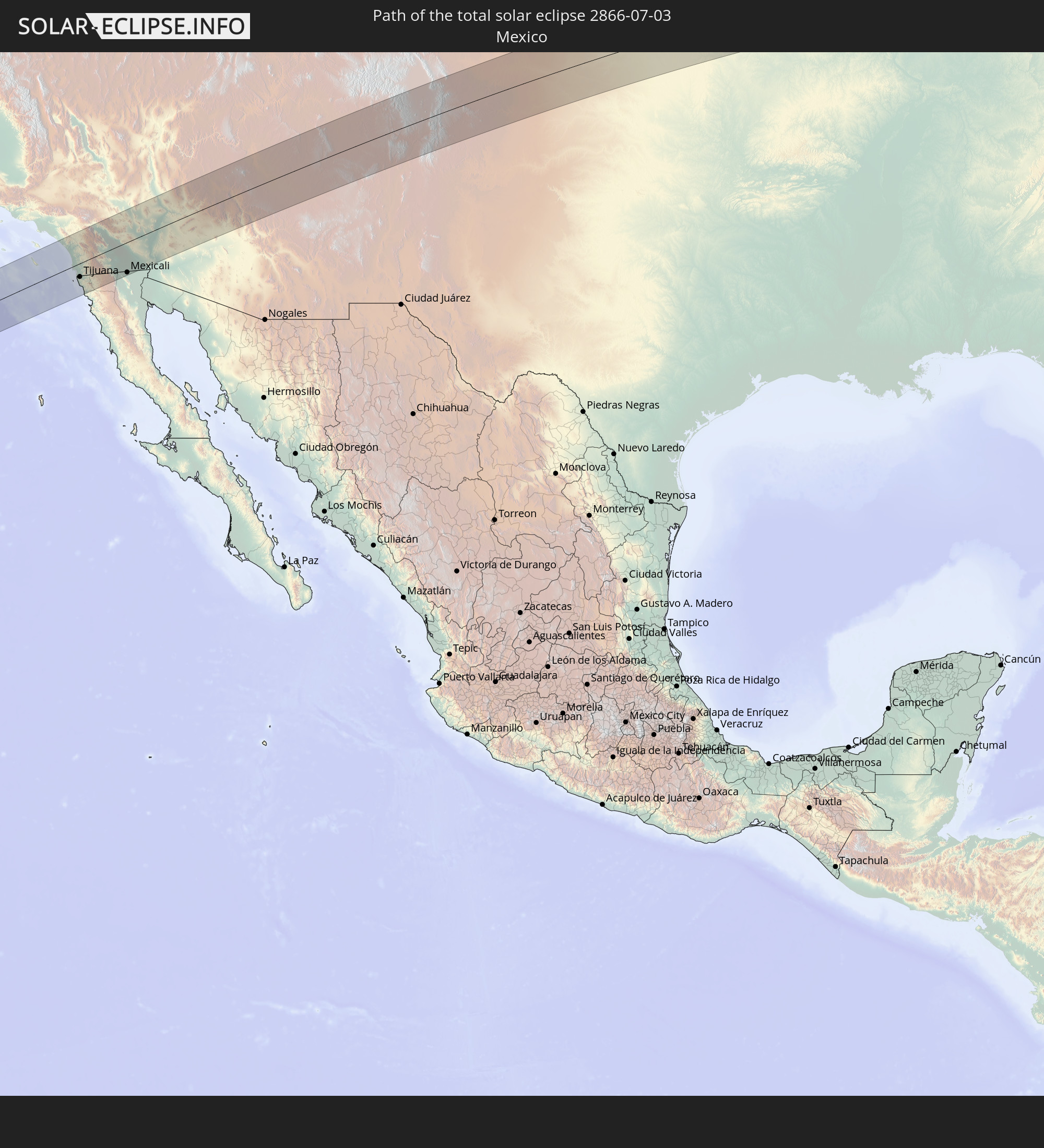 Mexiko
 Senegal
 Mauretanien
 Guinea
 Mali
Mali
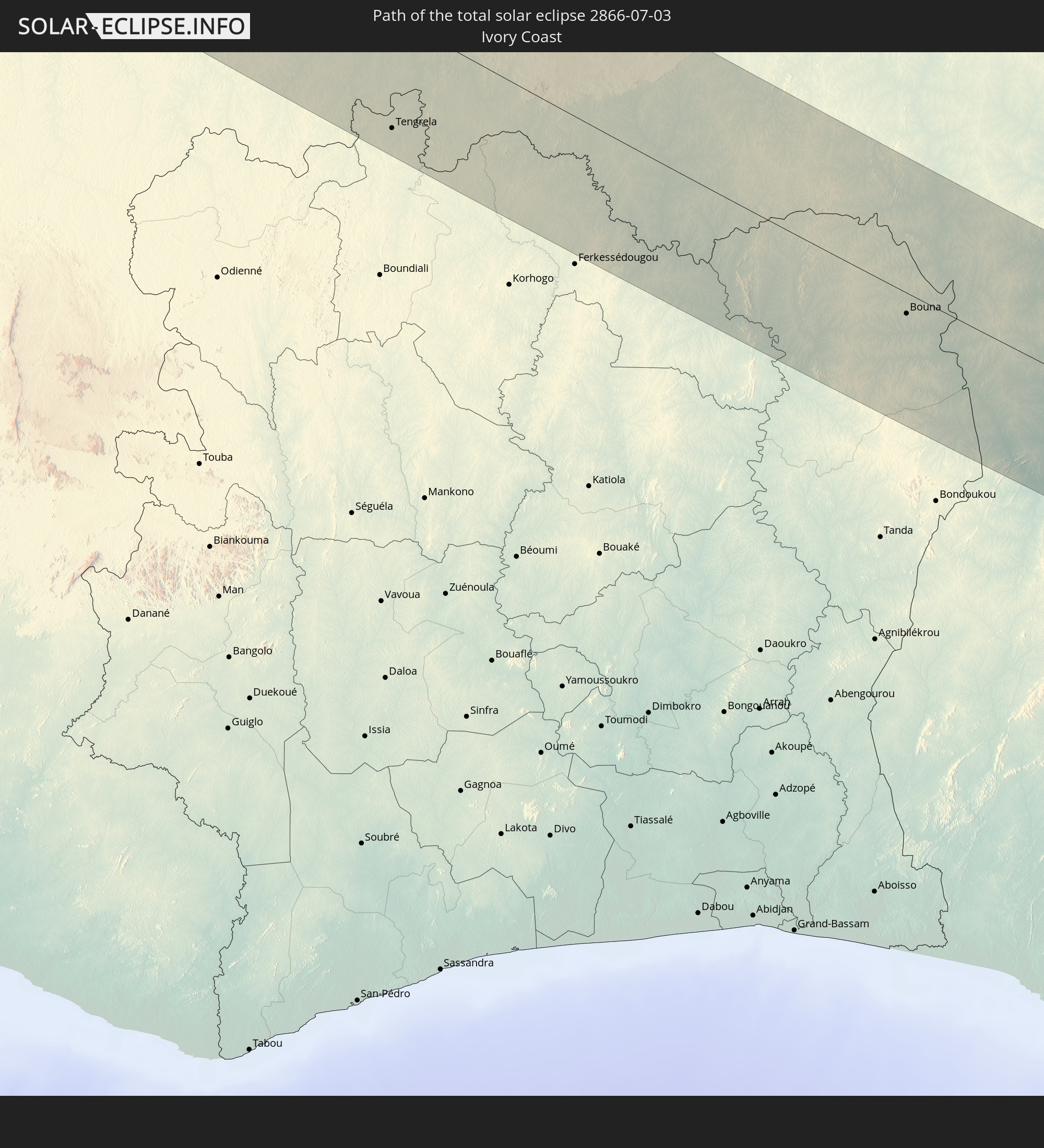 Elfenbeinküste
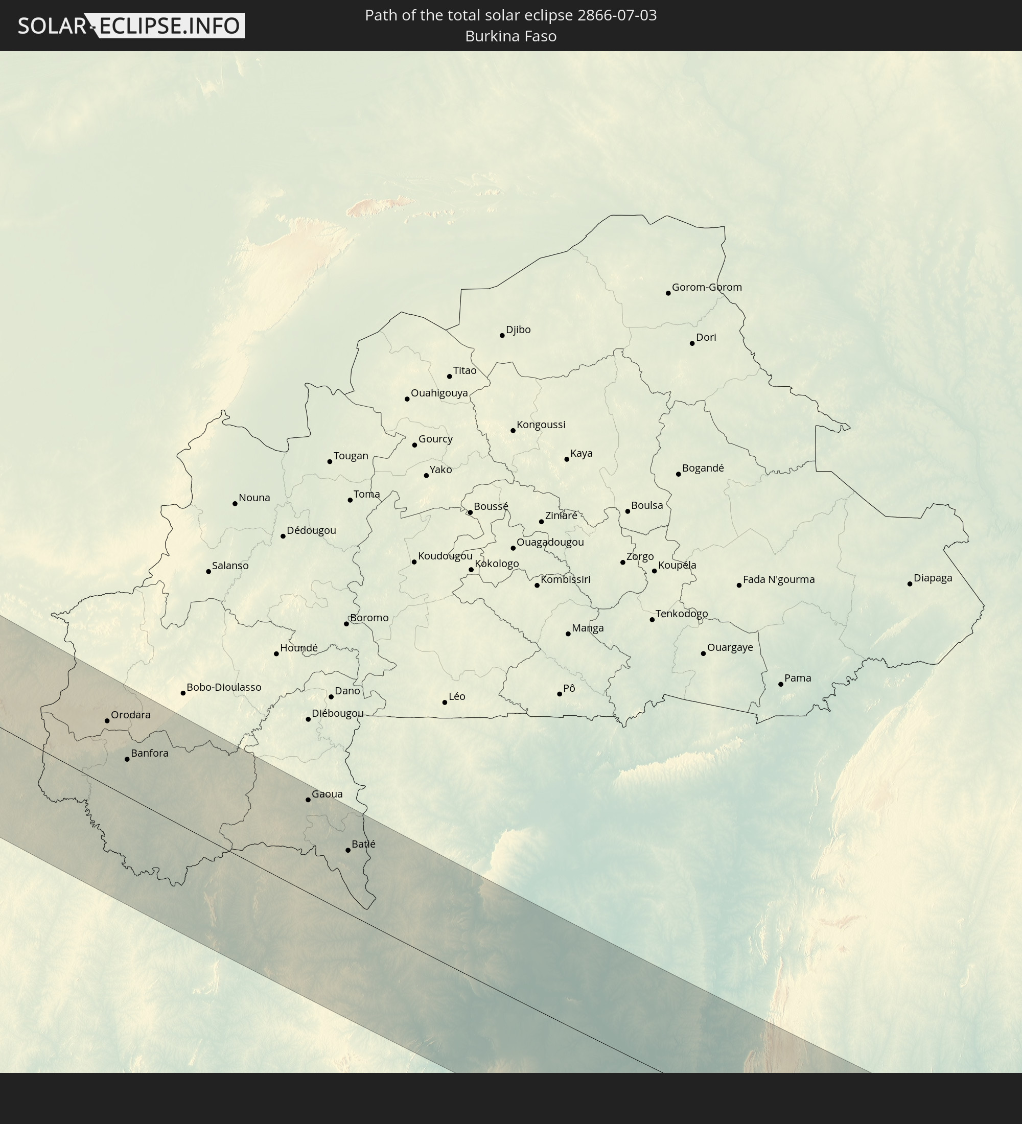 Burkina Faso
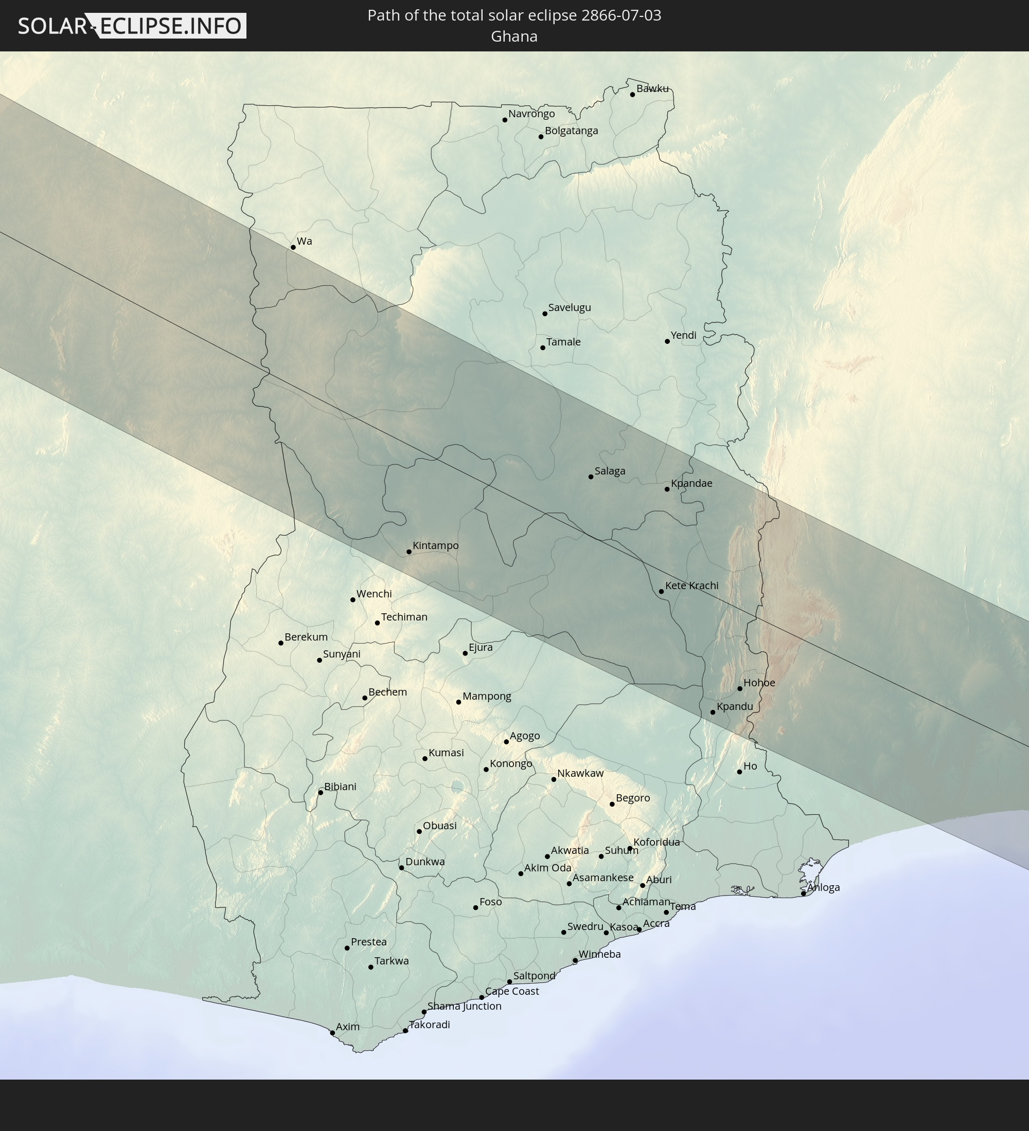 Ghana
Ghana
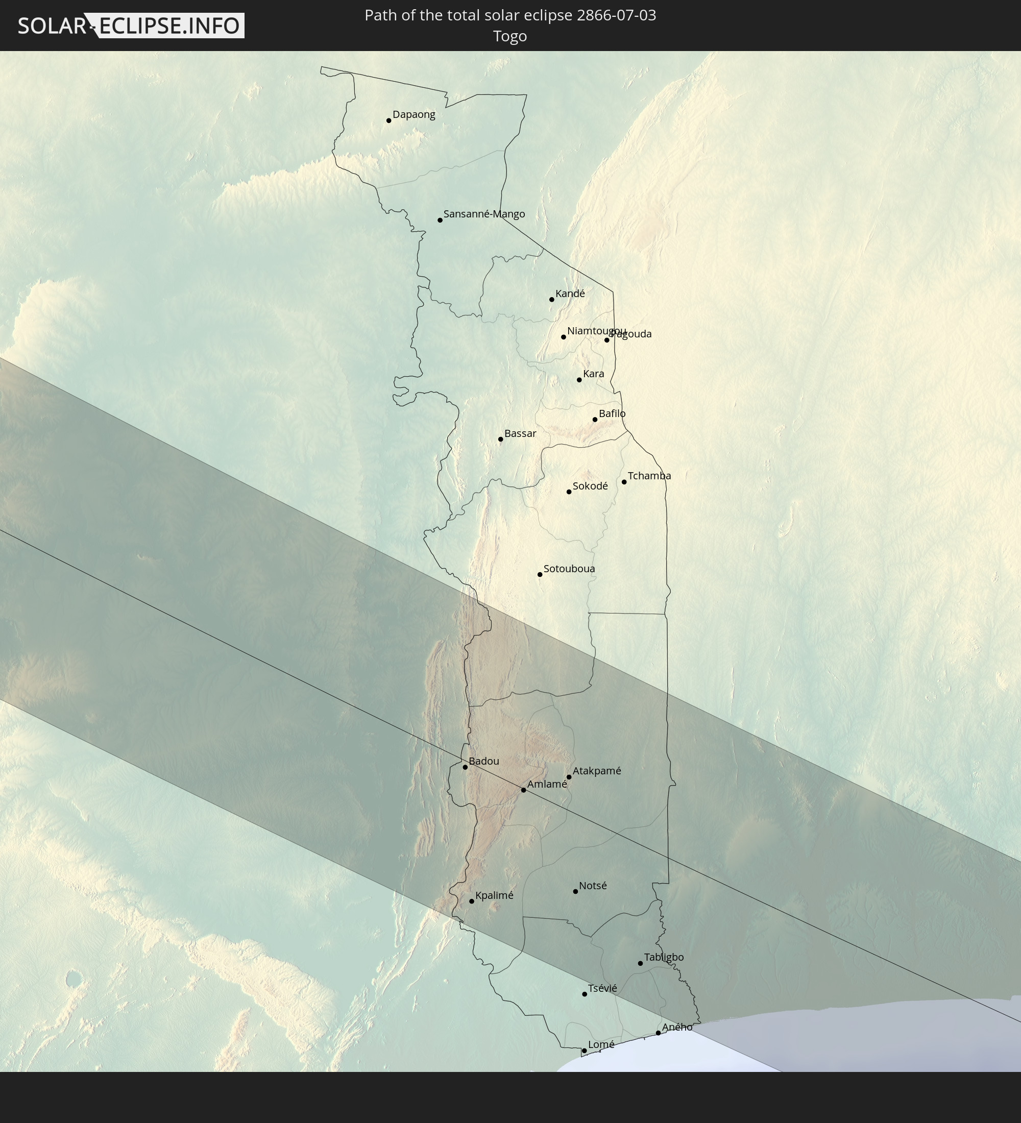 Togo
Togo
 Benin
Benin
 Nigeria
In den folgenden Ländern ist die Sonnenfinsternis partiell zu sehen
 Vereinigte Staaten
 United States Minor Outlying Islands
 Kanada
 Mexiko
 Grönland
 Guatemala
 El Salvador
 Honduras
 Belize
 Nicaragua
 Costa Rica
 Kuba
Kuba
 Kolumbien
 Kaimaninseln
 Bahamas
 Jamaika
 Haiti
Haiti
 Brasilien
 Venezuela
 Turks- und Caicosinseln
 Dominikanische Republik
 Aruba
Aruba
 Puerto Rico
 Amerikanische Jungferninseln
 Bermuda
 Britische Jungferninseln
 Anguilla
 Saint-Martin
 Saint-Barthélemy
 St. Kitts und Nevis
 Antigua und Barbuda
 Montserrat
 Trinidad und Tobago
 Guadeloupe
 Grenada
 Dominica
 St. Vincent und die Grenadinen
 Guyana
 Martinique
 St. Lucia
 Barbados
 Suriname
 Saint-Pierre und Miquelon
 Französisch-Guayana
 Portugal
 Kap Verde
 Island
 Spanien
 Senegal
 Mauretanien
 Gambia
 Guinea-Bissau
 Guinea
 St. Helena
 Sierra Leone
 Marokko
 Mali
Mali
 Liberia
 Irland
 Algerien
 Vereinigtes Königreich
 Elfenbeinküste
 Färöer
 Burkina Faso
 Gibraltar
 Frankreich
 Isle of Man
 Ghana
Ghana
 Guernsey
 Jersey
 Togo
Togo
 Niger
Niger
 Benin
Benin
 Andorra
 Belgien
 Nigeria
 Niederlande
 Norwegen
 Luxemburg
 Deutschland
 Schweiz
 Italien
 Monaco
 Tunesien
 Dänemark
 Libyen
 Liechtenstein
 Österreich
 Tschechien
 San Marino
 Vatikanstadt
 Slowenien
 Tschad
 Kroatien
 Polen
Polen
 Malta
Malta
 Bosnien und Herzegowina
 Ungarn
 Slowakei
 Montenegro
 Serbien
 Albanien
 Griechenland
 Rumänien
 Mazedonien
 Bulgarien
 Ägypten
 Türkei
Wie wird das Wetter während der totalen Sonnenfinsternis am 03.07.2866?
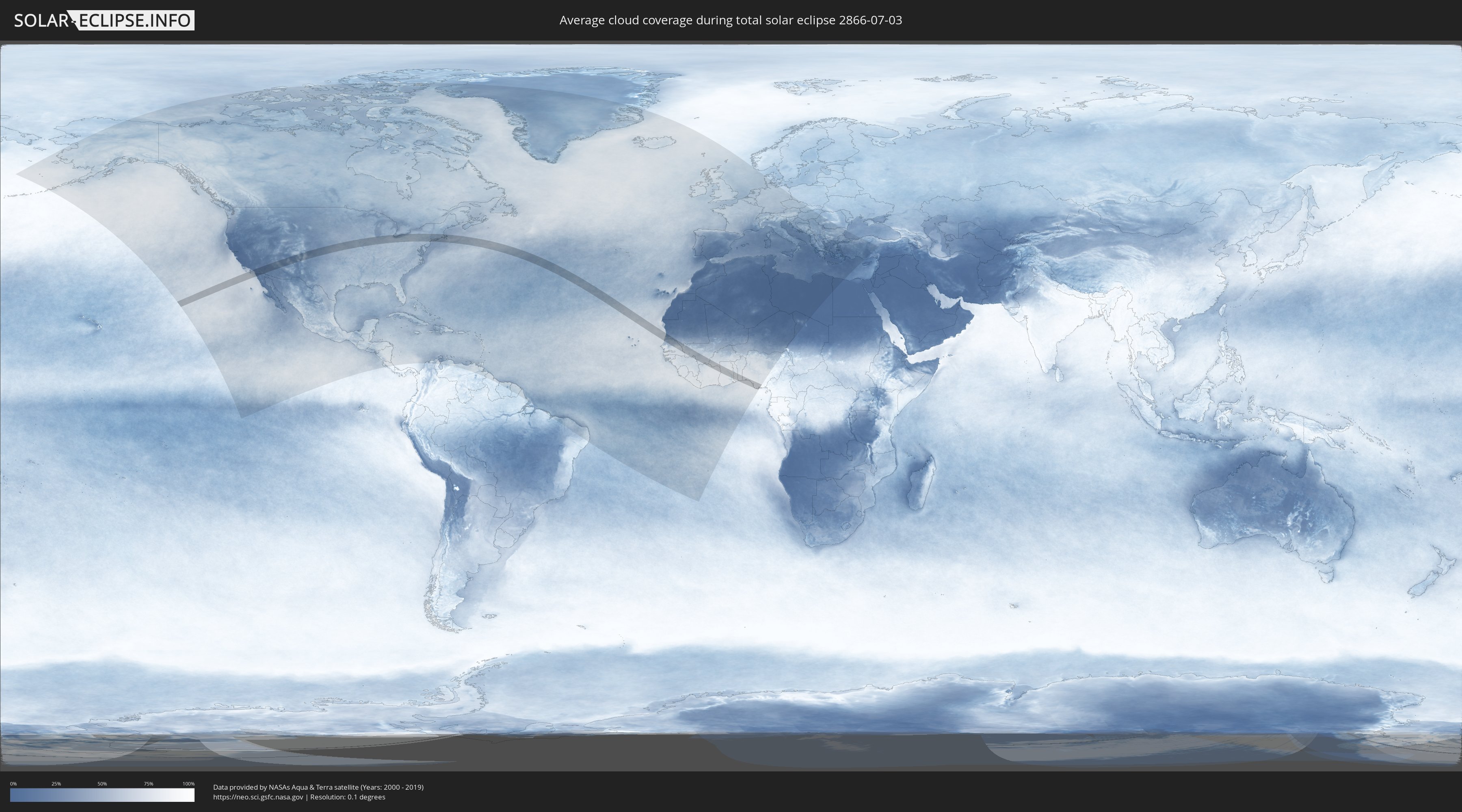
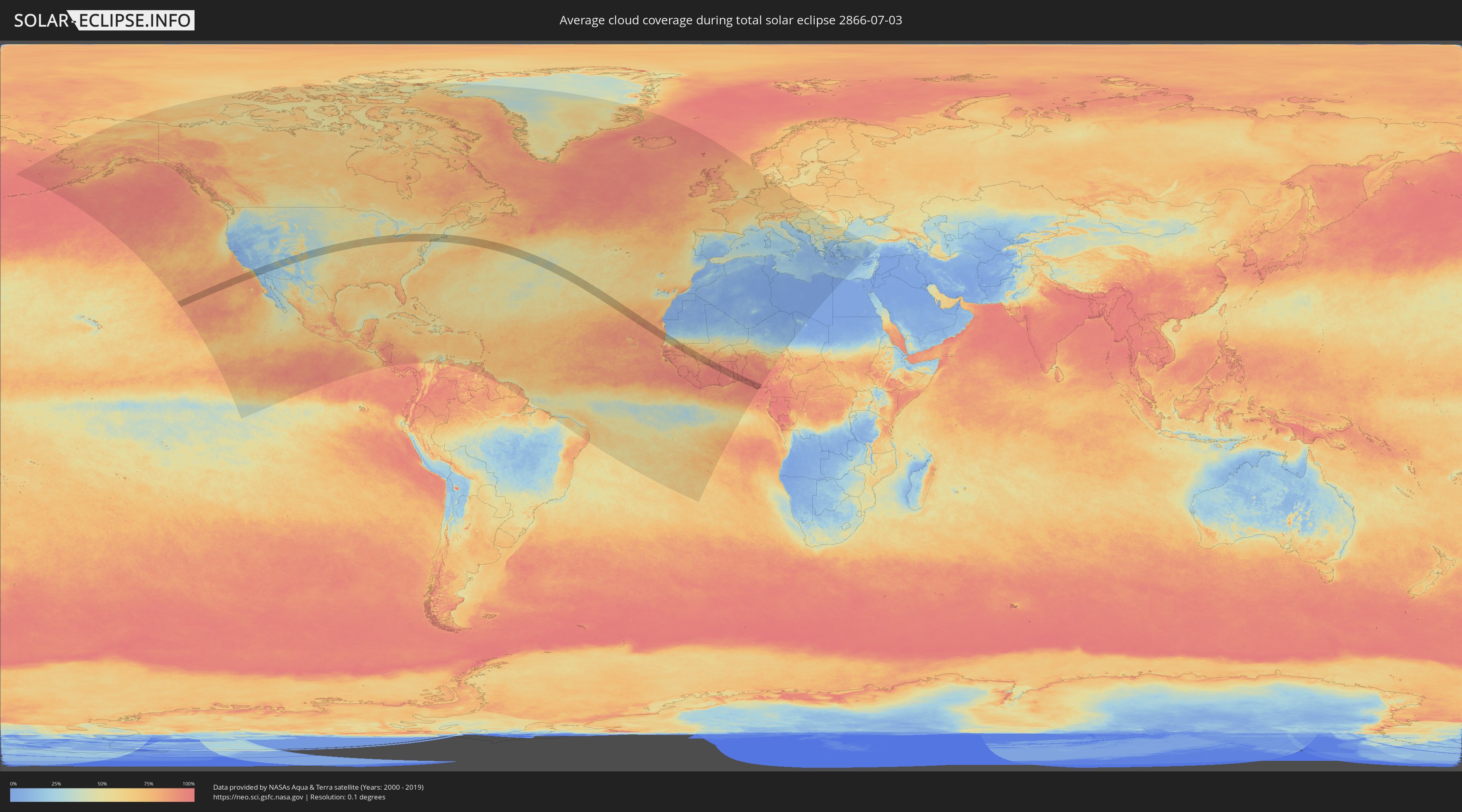
Wo ist der beste Ort, um die totale Sonnenfinsternis vom 03.07.2866 zu beobachten?
Die folgenden Karten zeigen die durchschnittliche Bewölkung für den Tag, an dem die totale Sonnenfinsternis
stattfindet. Mit Hilfe der Karten lässt sich der Ort entlang des Finsternispfades eingrenzen,
der die besten Aussichen auf einen klaren wolkenfreien Himmel bietet.
Trotzdem muss man immer lokale Gegenenheiten beachten und sollte sich genau über das Wetter an seinem
gewählten Beobachtungsort informieren.
Die Daten stammen von den beiden NASA-Satelliten
AQUA und TERRA
und wurden über einen Zeitraum von 19 Jahren (2000 - 2019) gemittelt.
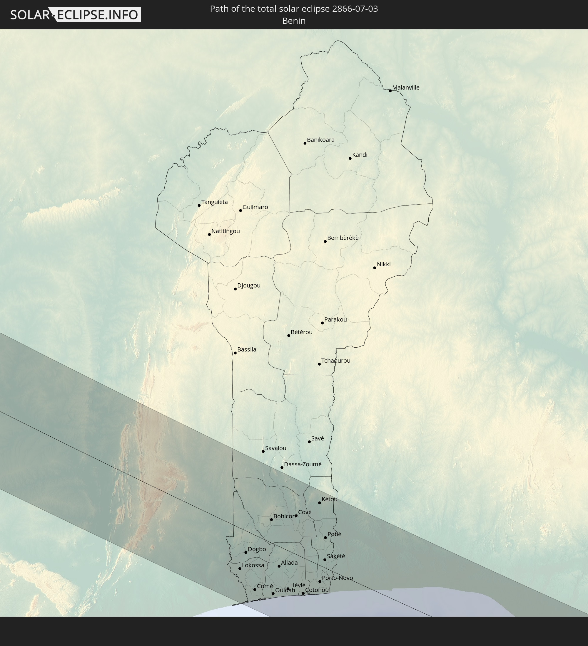
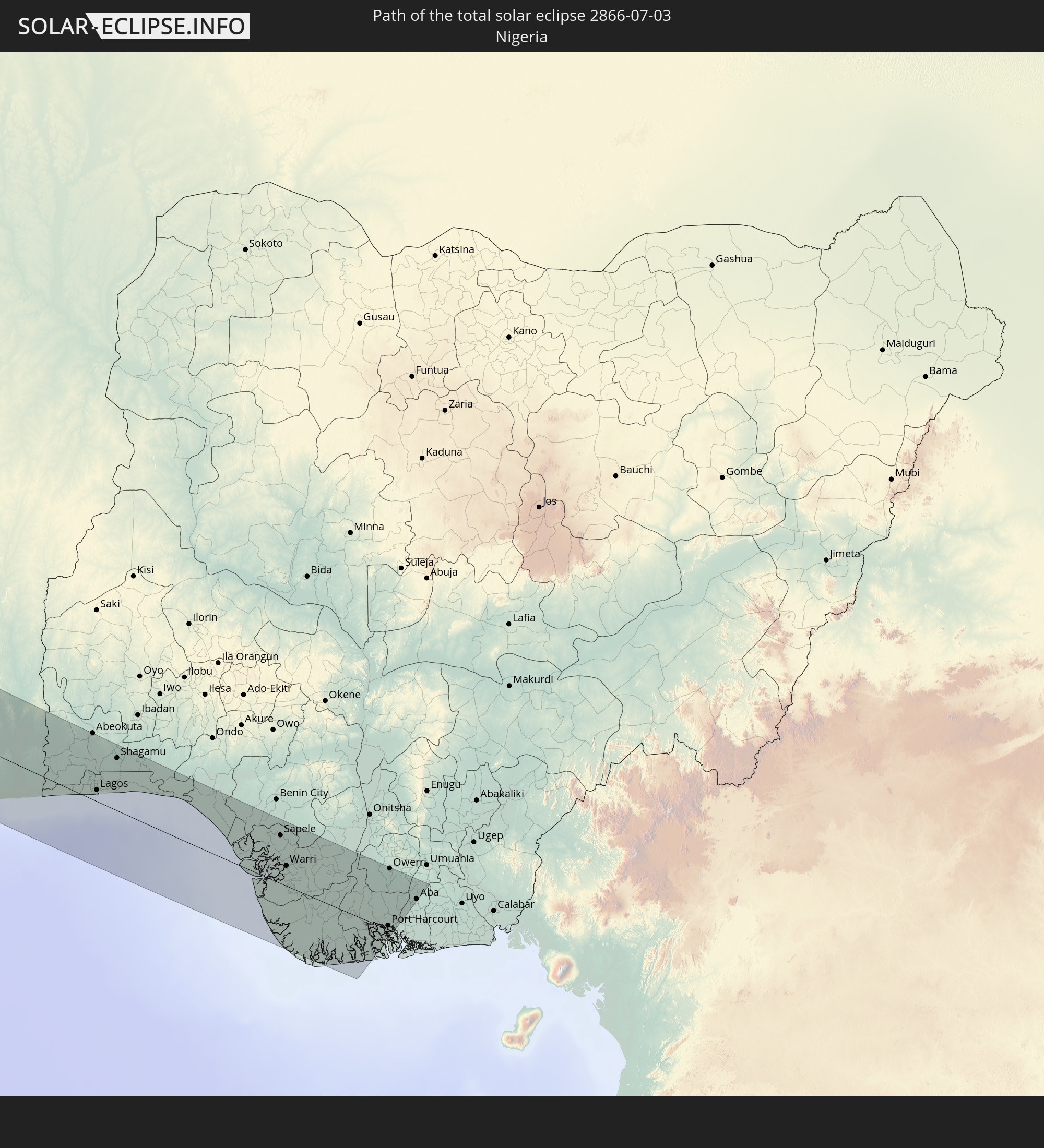
Detaillierte Länderkarten
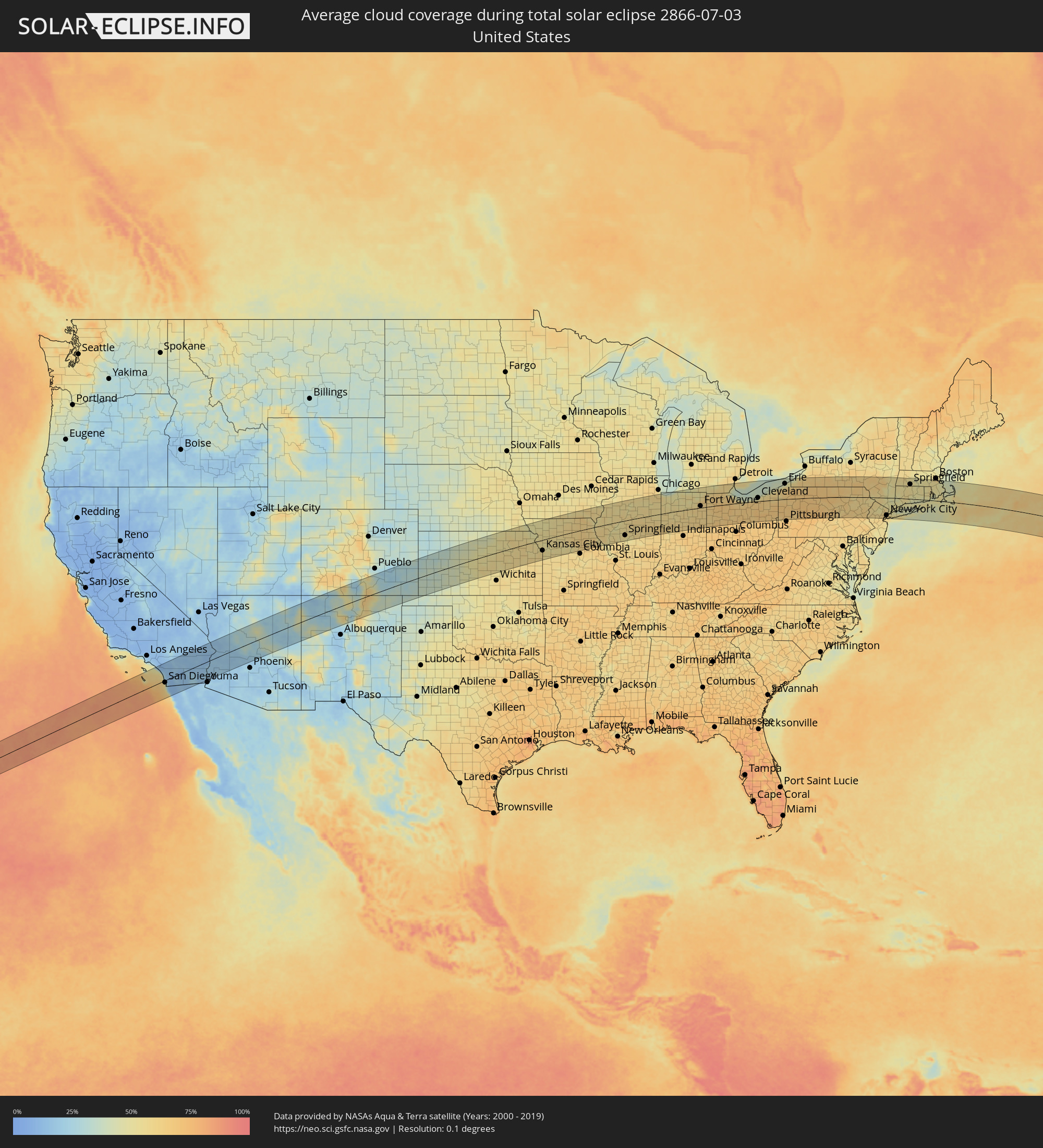 Vereinigte Staaten
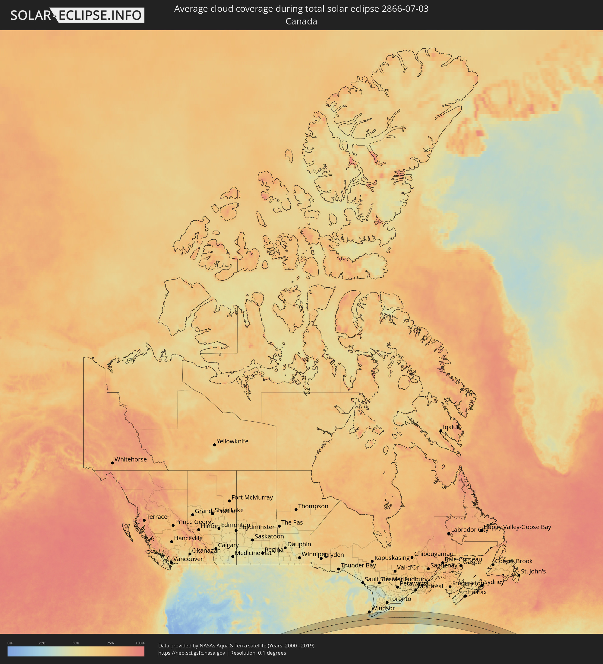 Kanada
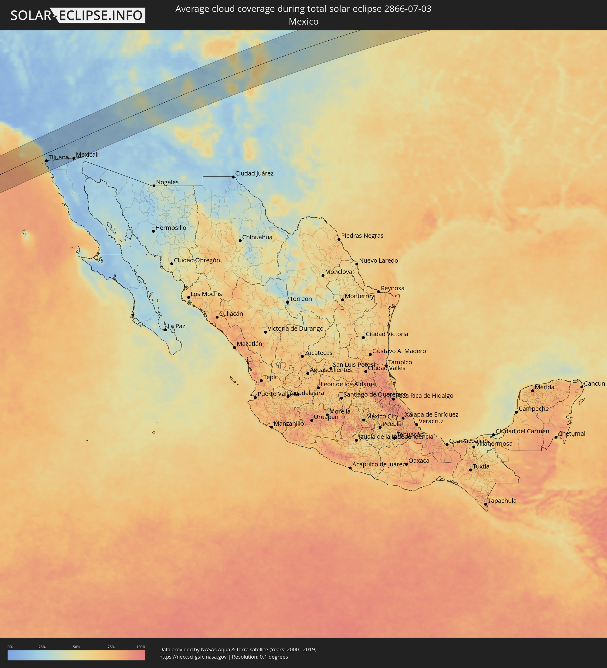 Mexiko
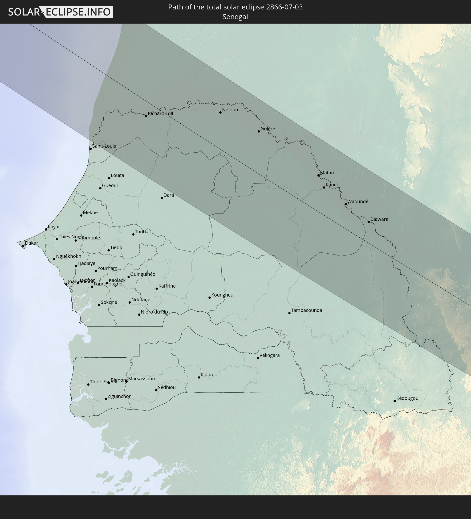
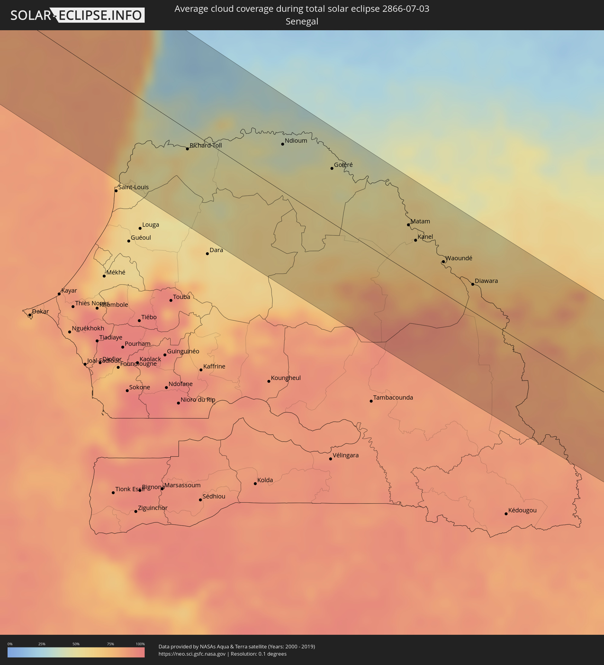 Senegal
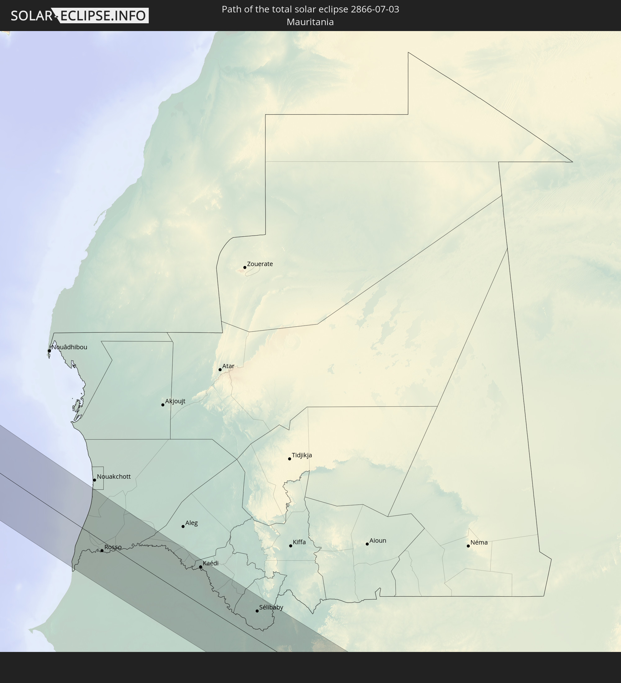
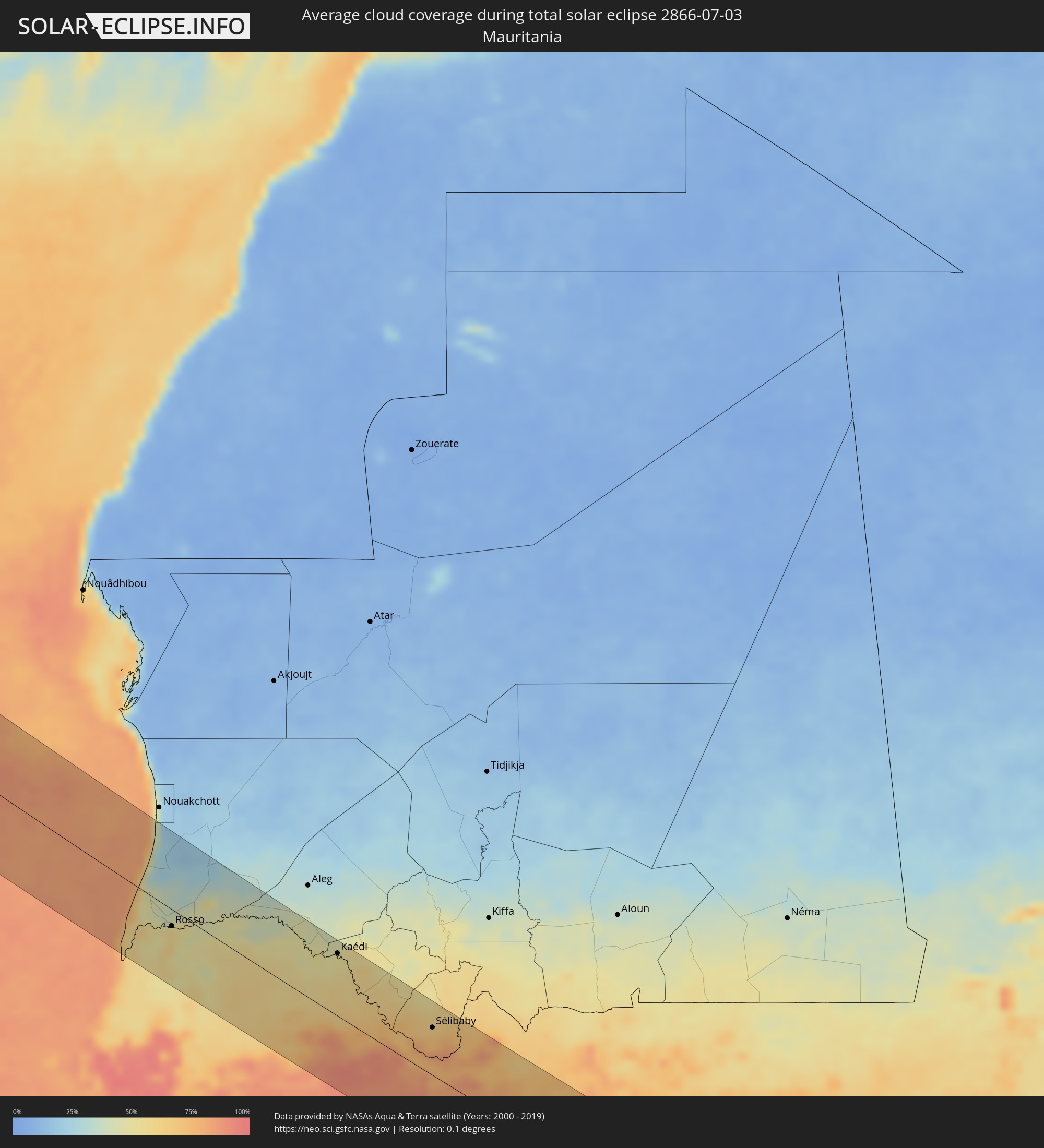 Mauretanien
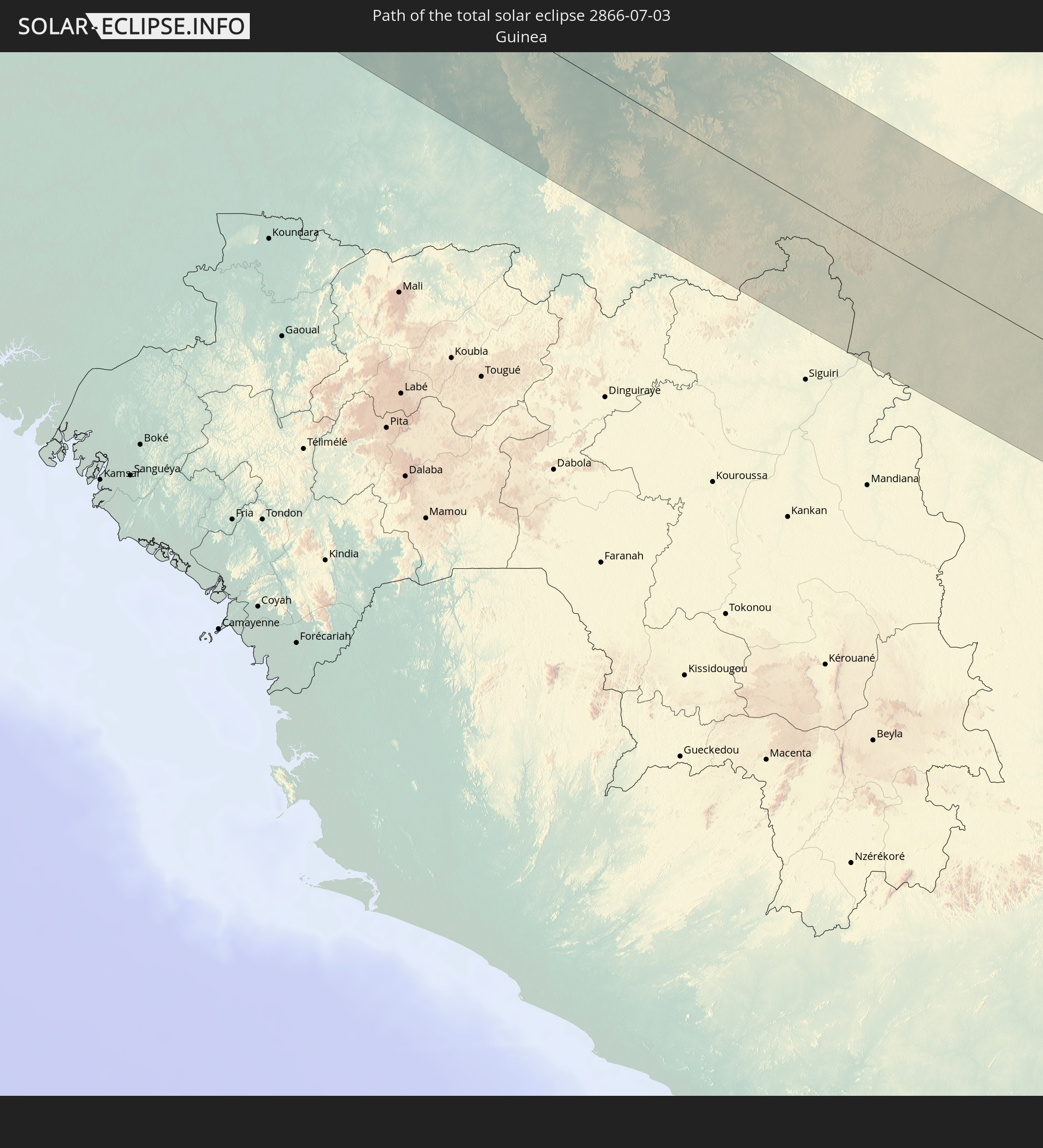
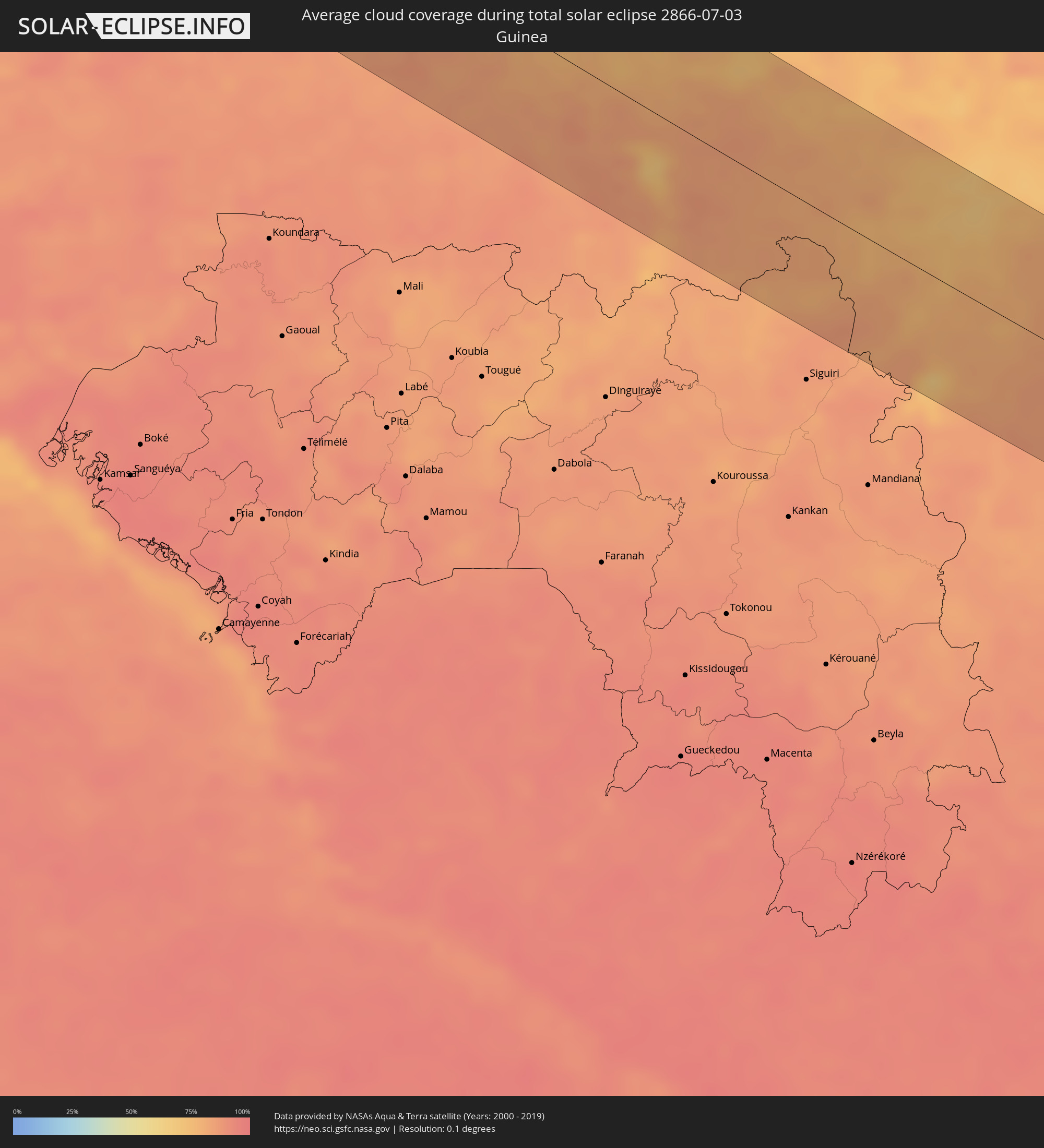 Guinea
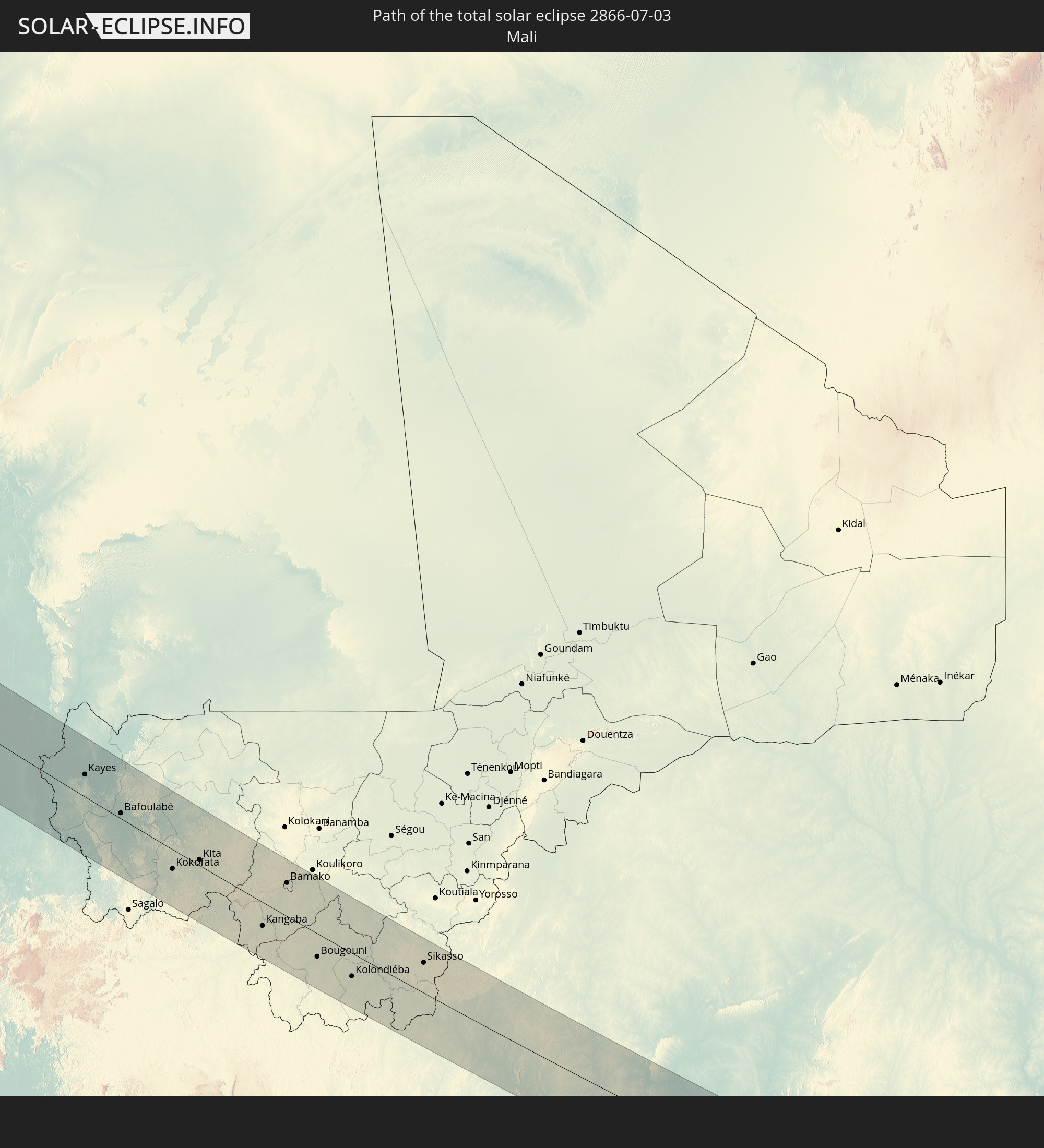
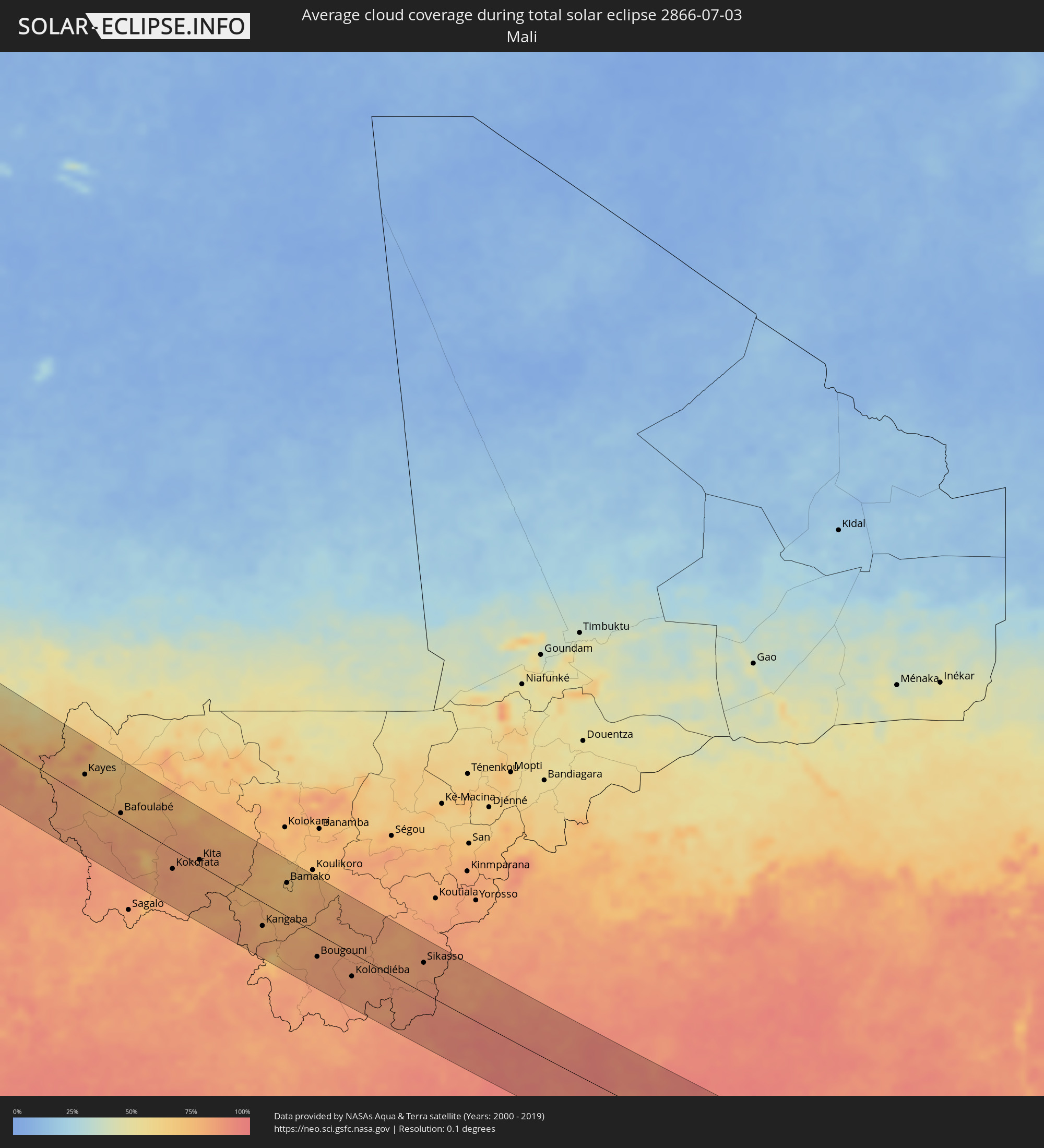 Mali
Mali
 Elfenbeinküste
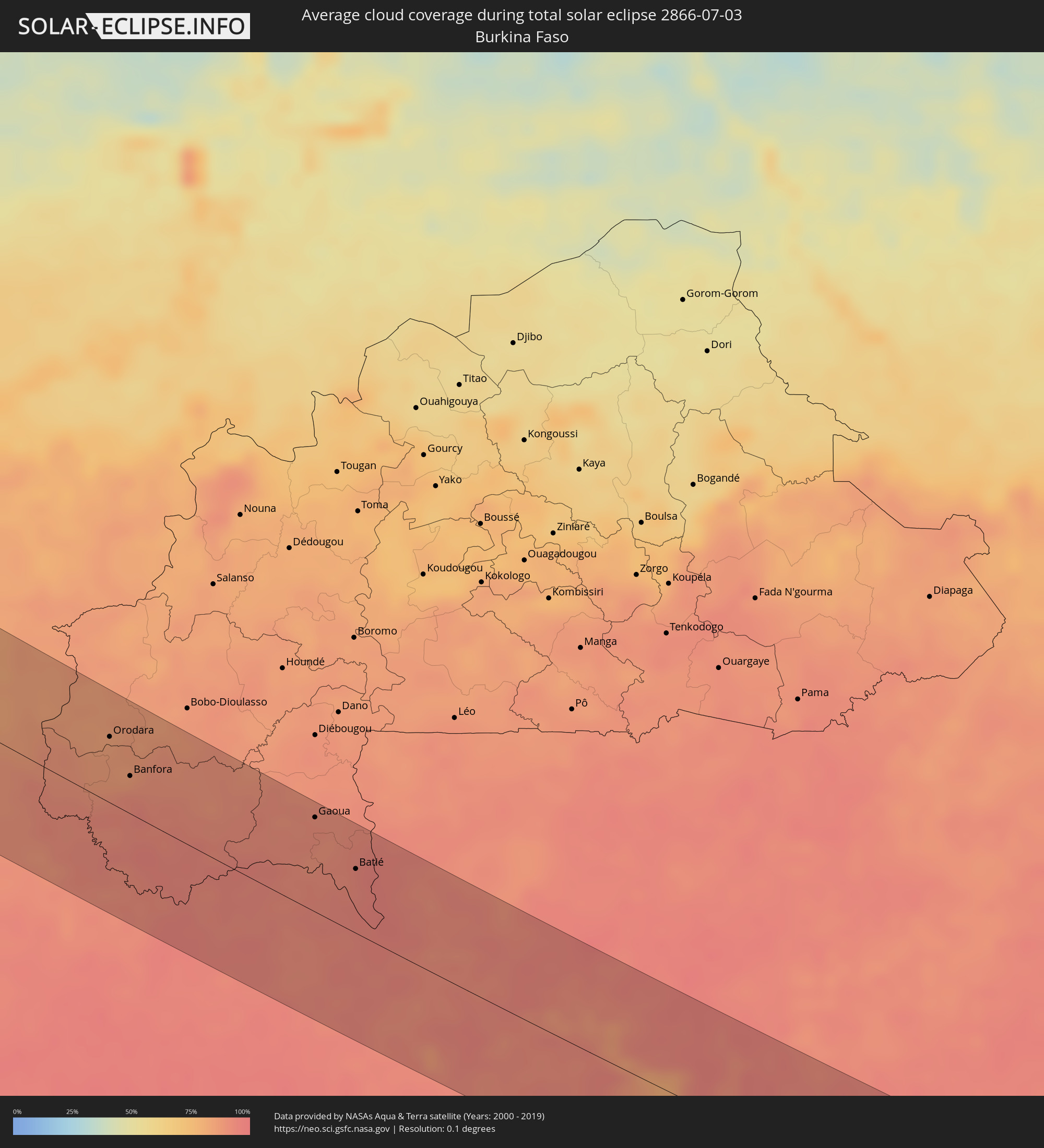 Burkina Faso
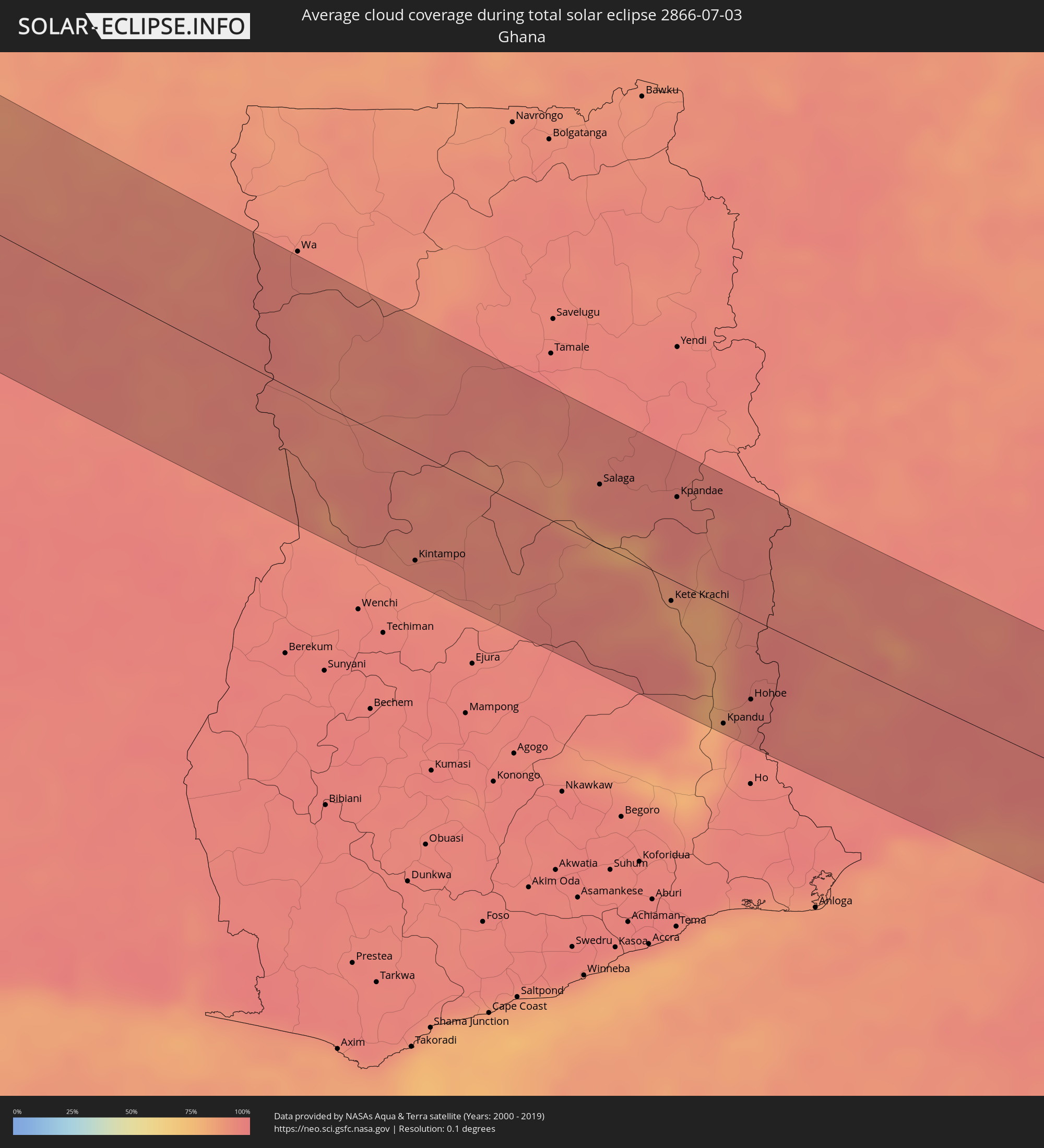 Ghana
Ghana
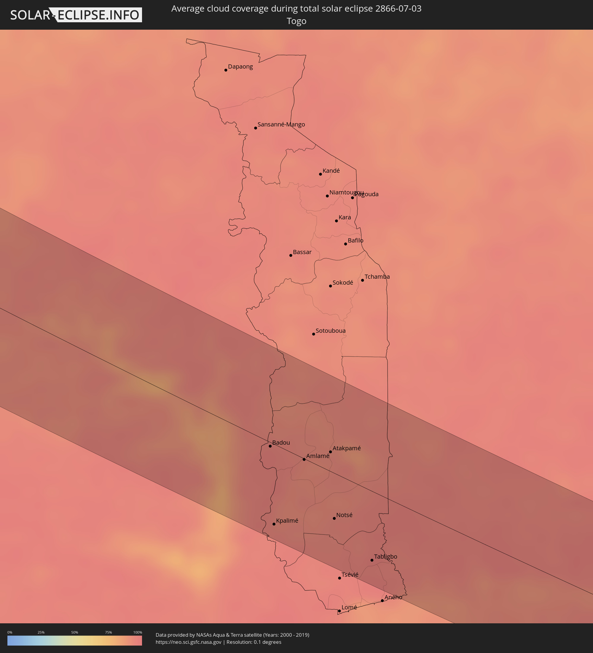 Togo
Togo
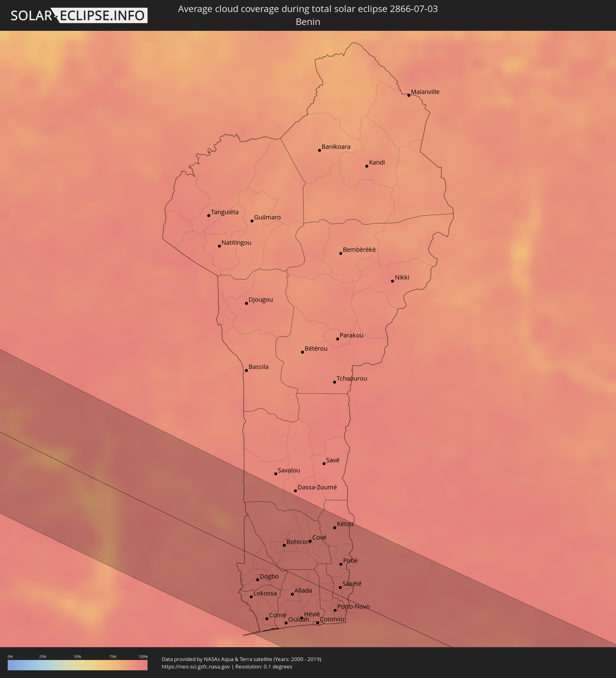 Benin
Benin
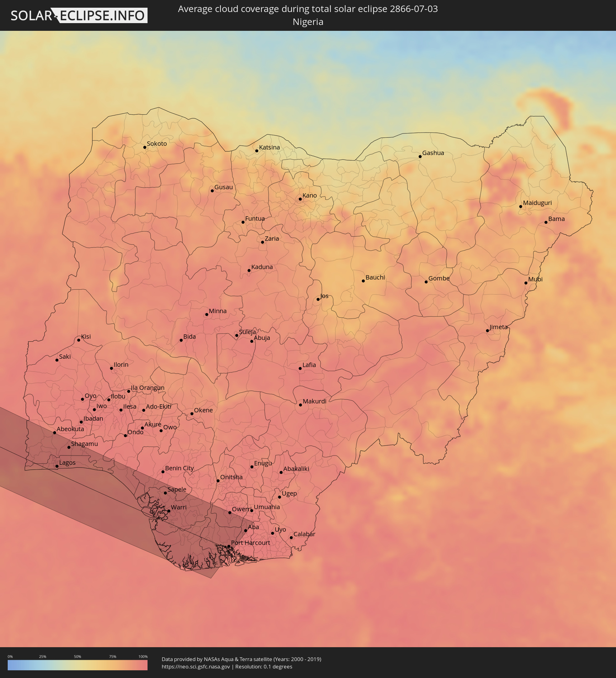 Nigeria
Orte im Finsternispfad
Die nachfolgene Tabelle zeigt Städte und Orte mit mehr als 5.000 Einwohnern, die sich im Finsternispfad befinden. Städte mit mehr als 100.000 Einwohnern sind dick gekennzeichnet. Mit einem Klick auf den Ort öffnet sich eine Detailkarte die die Lage des jeweiligen Ortes zusammen mit dem Verlauf der zentralen Finsternis präsentiert.
| Ort | Typ | Dauer der Verfinsterung | Ortszeit bei maximaler Verfinsterung | Entfernung zur Zentrallinie | Ø Bewölkung |
|
Oceanside, California
|
total | - | 06:31:25 UTC-08:00 | 46 km | 49% |
|
San Diego, California
|
total | - | 06:31:01 UTC-08:00 | 11 km | 53% |
|
Quinta del Cedro, Baja California
|
total | - | 06:30:46 UTC-08:00 | 43 km | 54% |
|
Rosarito, Baja California
|
total | - | 06:30:42 UTC-08:00 | 51 km | 29% |
|
Pórticos de San Antonio, Baja California
|
total | - | 06:30:47 UTC-08:00 | 43 km | 29% |
|
Tijuana, Baja California
|
total | - | 06:30:51 UTC-08:00 | 38 km | 20% |
|
Villa del Prado 2da Sección, Baja California
|
total | - | 06:30:47 UTC-08:00 | 48 km | 29% |
|
San Luis, Baja California
|
total | - | 06:30:48 UTC-08:00 | 47 km | 29% |
|
Las Delicias, Baja California
|
total | - | 06:30:47 UTC-08:00 | 50 km | 15% |
|
Primo Tapia, Baja California
|
total | - | 06:30:37 UTC-08:00 | 70 km | 45% |
|
Terrazas del Valle, Baja California
|
total | - | 06:30:54 UTC-08:00 | 47 km | 11% |
|
Maclovio Rojas, Baja California
|
total | - | 06:30:53 UTC-08:00 | 49 km | 11% |
|
El Niño, Baja California
|
total | - | 06:30:55 UTC-08:00 | 46 km | 11% |
|
Villa del Campo, Baja California
|
total | - | 06:30:56 UTC-08:00 | 48 km | 11% |
|
Lomas de Santa Anita, Baja California
|
total | - | 06:31:00 UTC-08:00 | 48 km | 11% |
|
Tecate, Baja California
|
total | - | 06:31:02 UTC-08:00 | 46 km | 11% |
|
Progreso, Baja California
|
total | - | 06:31:23 UTC-08:00 | 85 km | 16% |
|
Mexicali, Baja California
|
total | - | 06:31:29 UTC-08:00 | 85 km | 17% |
|
Overland Park, Kansas
|
total | - | 08:53:37 UTC-06:00 | 63 km | 58% |
|
Kansas City, Missouri
|
total | - | 08:53:50 UTC-06:00 | 53 km | 56% |
|
Joliet, Illinois
|
total | - | 09:04:20 UTC-06:00 | 91 km | 57% |
|
Fort Wayne, Indiana
|
total | - | 10:08:19 UTC-05:00 | 9 km | 59% |
|
Toledo, Ohio
|
total | - | 10:11:06 UTC-05:00 | 51 km | 61% |
|
Amherstburg, Ontario
|
total | - | 10:12:11 UTC-05:00 | 96 km | 49% |
|
Cleveland, Ohio
|
total | - | 10:13:58 UTC-05:00 | 17 km | 57% |
|
Akron, Ohio
|
total | - | 10:14:01 UTC-05:00 | 31 km | 67% |
|
Paterson, New Jersey
|
total | - | 10:27:01 UTC-05:00 | 66 km | 61% |
|
New York City, New York
|
total | - | 10:27:17 UTC-05:00 | 88 km | 58% |
|
The Bronx, New York
|
total | - | 10:27:35 UTC-05:00 | 72 km | 58% |
|
Jamaica, New York
|
total | - | 10:27:40 UTC-05:00 | 90 km | 54% |
|
Bridgeport, Connecticut
|
total | - | 10:28:53 UTC-05:00 | 34 km | 48% |
|
Springfield, Massachusetts
|
total | - | 10:30:10 UTC-05:00 | 72 km | 53% |
|
Worcester, Massachusetts
|
total | - | 10:31:39 UTC-05:00 | 94 km | 53% |
|
Providence, Rhode Island
|
total | - | 10:32:21 UTC-05:00 | 48 km | 55% |
|
Rosso, Trarza
|
total | - | 17:33:02 UTC+00:00 | 21 km | 58% |
|
Rosso, Saint-Louis
|
total | - | 17:33:09 UTC+00:00 | 29 km | 58% |
|
Richard-Toll, Saint-Louis
|
total | - | 17:33:08 UTC+00:00 | 19 km | 54% |
|
Tékane, Trarza
|
total | - | 17:33:06 UTC+00:00 | 6 km | 49% |
|
Ndioum, Saint-Louis
|
total | - | 17:33:33 UTC+00:00 | 47 km | 39% |
|
Goléré, Saint-Louis
|
total | - | 17:34:06 UTC+00:00 | 54 km | 50% |
|
Kaédi, Gorgol
|
total | - | 17:34:28 UTC+00:00 | 79 km | 52% |
|
Ouro Sogui, Matam
|
total | - | 17:35:12 UTC+00:00 | 38 km | 59% |
|
Matam, Matam
|
total | - | 17:35:10 UTC+00:00 | 46 km | 58% |
|
Kanel, Matam
|
total | - | 17:35:23 UTC+00:00 | 36 km | 61% |
|
Sémé, Matam
|
total | - | 17:35:50 UTC+00:00 | 21 km | 74% |
|
Waoundé, Matam
|
total | - | 17:35:46 UTC+00:00 | 32 km | 73% |
|
Diawara, Matam
|
total | - | 17:36:10 UTC+00:00 | 27 km | 74% |
|
Sélibaby, Guidimaka
|
total | - | 17:36:08 UTC+00:00 | 61 km | 67% |
|
Kayes, Kayes
|
total | - | 17:37:12 UTC+00:00 | 35 km | 77% |
|
Bafoulabé, Kayes
|
total | - | 17:38:06 UTC+00:00 | 9 km | 80% |
|
Kokofata
|
total | - | 17:39:21 UTC+00:00 | 31 km | 86% |
|
Kita, Kayes
|
total | - | 17:39:17 UTC+00:00 | 9 km | 81% |
|
Kangaba, Koulikoro
|
total | - | 17:40:40 UTC+00:00 | 38 km | 79% |
|
Kati, Koulikoro
|
total | - | 17:39:53 UTC+00:00 | 59 km | 70% |
|
Bamako, Bamako
|
total | - | 17:39:59 UTC+00:00 | 54 km | 70% |
|
Bougouni, Sikasso
|
total | - | 17:41:21 UTC+00:00 | 38 km | 84% |
|
Kolondiéba, Sikasso
|
total | - | 17:41:46 UTC+00:00 | 38 km | 85% |
|
Tengrela, Savanes
|
total | - | 17:42:25 UTC+00:00 | 71 km | 87% |
|
Sikasso, Sikasso
|
total | - | 17:41:40 UTC+00:00 | 49 km | 85% |
|
Orodara, Hauts-Bassins
|
total | - | 17:42:05 UTC+00:00 | 52 km | 86% |
|
Banfora, Cascades
|
total | - | 17:42:24 UTC+00:00 | 30 km | 92% |
|
Gaoua, Sud-Ouest
|
total | - | 17:42:46 UTC+00:00 | 75 km | 91% |
|
Bouna, Zanzan
|
total | - | 17:43:43 UTC+00:00 | 13 km | 94% |
|
Batié, Sud-Ouest
|
total | - | 17:43:10 UTC+00:00 | 51 km | 94% |
|
Kintampo, Brong-Ahafo
|
total | - | 17:44:45 UTC+00:00 | 70 km | 93% |
|
Salaga, Northern
|
total | - | 17:44:15 UTC+00:00 | 39 km | 94% |
|
Kete Krachi
|
total | - | 17:44:51 UTC+00:00 | 14 km | 81% |
|
Kpandae
|
total | - | 17:44:17 UTC+00:00 | 55 km | 94% |
|
Kpandu, Volta
|
total | - | 17:45:28 UTC+00:00 | 77 km | 90% |
|
Hohoe, Volta
|
total | - | 17:45:20 UTC+00:00 | 53 km | 96% |
|
Badou, Plateaux
|
total | - | 17:44:58 UTC+00:00 | 4 km | 97% |
|
Kpalimé, Plateaux
|
total | - | 17:45:31 UTC+00:00 | 70 km | 94% |
|
Amlamé, Plateaux
|
total | - | 17:45:01 UTC+00:00 | 1 km | 93% |
|
Atakpamé, Plateaux
|
total | - | 17:44:56 UTC+00:00 | 17 km | 92% |
|
Notsé, Plateaux
|
total | - | 17:45:24 UTC+00:00 | 40 km | 94% |
|
Tabligbo, Maritime
|
total | - | 17:45:39 UTC+00:00 | 61 km | 96% |
|
Aplahoué, Kouffo
|
total | - | 18:45:21 UTC+01:00 | 17 km | 96% |
|
Lokossa, Mono
|
total | - | 18:45:34 UTC+01:00 | 45 km | 95% |
|
Dogbo, Kouffo
|
total | - | 18:45:25 UTC+01:00 | 24 km | 95% |
|
Grand-Popo, Mono
|
total | - | 18:45:50 UTC+01:00 | 76 km | 88% |
|
Comé, Mono
|
total | - | 18:45:44 UTC+01:00 | 61 km | 91% |
|
Abomey, Zou
|
total | - | 18:45:06 UTC+01:00 | 22 km | 96% |
|
Bohicon, Zou
|
total | - | 18:45:06 UTC+01:00 | 26 km | 96% |
|
Ouidah, Atlantique
|
total | - | 18:45:44 UTC+01:00 | 56 km | 91% |
|
Allada, Atlantique
|
total | - | 18:45:29 UTC+01:00 | 22 km | 97% |
|
Hévié, Atlantique
|
total | - | 18:45:40 UTC+01:00 | 43 km | 93% |
|
Cové, Zou
|
total | - | 18:45:01 UTC+01:00 | 43 km | 95% |
|
Abomey-Calavi, Atlantique
|
total | - | 18:45:37 UTC+01:00 | 34 km | 93% |
|
Cotonou, Littoral
|
total | - | 18:45:40 UTC+01:00 | 40 km | 93% |
|
Kétou, Plateau
|
total | - | 18:44:52 UTC+01:00 | 69 km | 95% |
|
Porto-Novo, Ouémé
|
total | - | 18:45:33 UTC+01:00 | 18 km | 92% |
|
Sakété, Plateau
|
total | - | 18:45:21 UTC+01:00 | 9 km | 97% |
|
Pobé, Plateau
|
total | - | 18:45:10 UTC+01:00 | 34 km | 96% |
|
Badagry, Lagos
|
total | - | 18:45:33 UTC+01:00 | 13 km | 89% |
|
Ilaro, Ogun
|
total | - | 18:45:10 UTC+01:00 | 41 km | 96% |
|
Ifo, Ogun
|
total | - | 18:45:12 UTC+01:00 | 42 km | 97% |
|
Ikeja, Lagos
|
total | - | 18:45:20 UTC+01:00 | 26 km | 97% |
|
Lagos, Lagos
|
total | - | 18:45:26 UTC+01:00 | 14 km | 95% |
|
Ebute Ikorodu, Lagos
|
total | - | 18:45:18 UTC+01:00 | 33 km | 94% |
|
Shagamu, Ogun
|
total | - | 18:45:05 UTC+01:00 | 66 km | 96% |
|
Ijebu-Ode, Ogun
|
total | - | 18:45:03 UTC+01:00 | 75 km | 97% |
|
Epe, Lagos
|
total | - | 18:45:13 UTC+01:00 | 54 km | 94% |
|
Sapele, Delta
|
total | - | 18:45:21 UTC+01:00 | 61 km | 97% |
|
Warri, Delta
|
total | - | 18:45:37 UTC+01:00 | 25 km | 97% |
|
Ughelli, Delta
|
total | - | 18:45:34 UTC+01:00 | 34 km | 97% |
|
Yenagoa, Bayelsa
|
total | - | 18:45:53 UTC+01:00 | 12 km | 95% |
|
Buguma, Rivers
|
total | - | 18:45:52 UTC+01:00 | 15 km | 95% |
|
Port Harcourt, Rivers
|
total | - | 18:45:47 UTC+01:00 | 5 km | 96% |
|
Owerri, Imo
|
total | - | 18:45:18 UTC+01:00 | 78 km | 97% |
|
Aba, Abia
|
total | - | 18:45:28 UTC+01:00 | 55 km | 97% |