Total solar eclipse of 07/03/2866
| Day of week: | Saturday |
| Maximum duration of eclipse: | 04m59s |
| Maximum width of eclipse path: | 209 km |
| Saros cycle: | 160 |
| Coverage: | 100% |
| Magnitude: | 1.061 |
| Gamma: | 0.2785 |
Wo kann man die Sonnenfinsternis vom 07/03/2866 sehen?
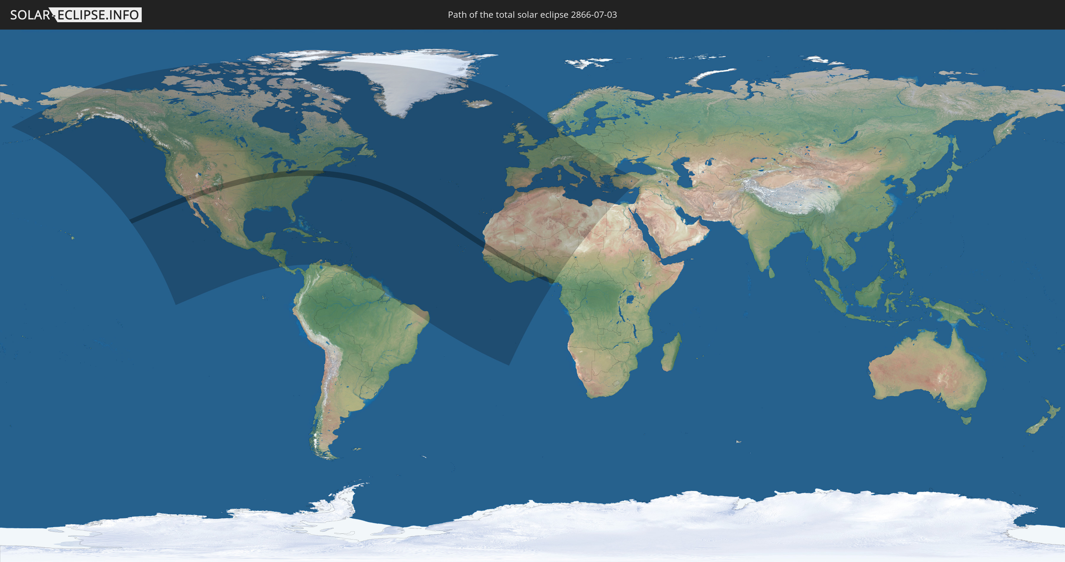
Die Sonnenfinsternis am 07/03/2866 kann man in 108 Ländern als partielle Sonnenfinsternis beobachten.
Der Finsternispfad verläuft durch 13 Länder. Nur in diesen Ländern ist sie als total Sonnenfinsternis zu sehen.
In den folgenden Ländern ist die Sonnenfinsternis total zu sehen
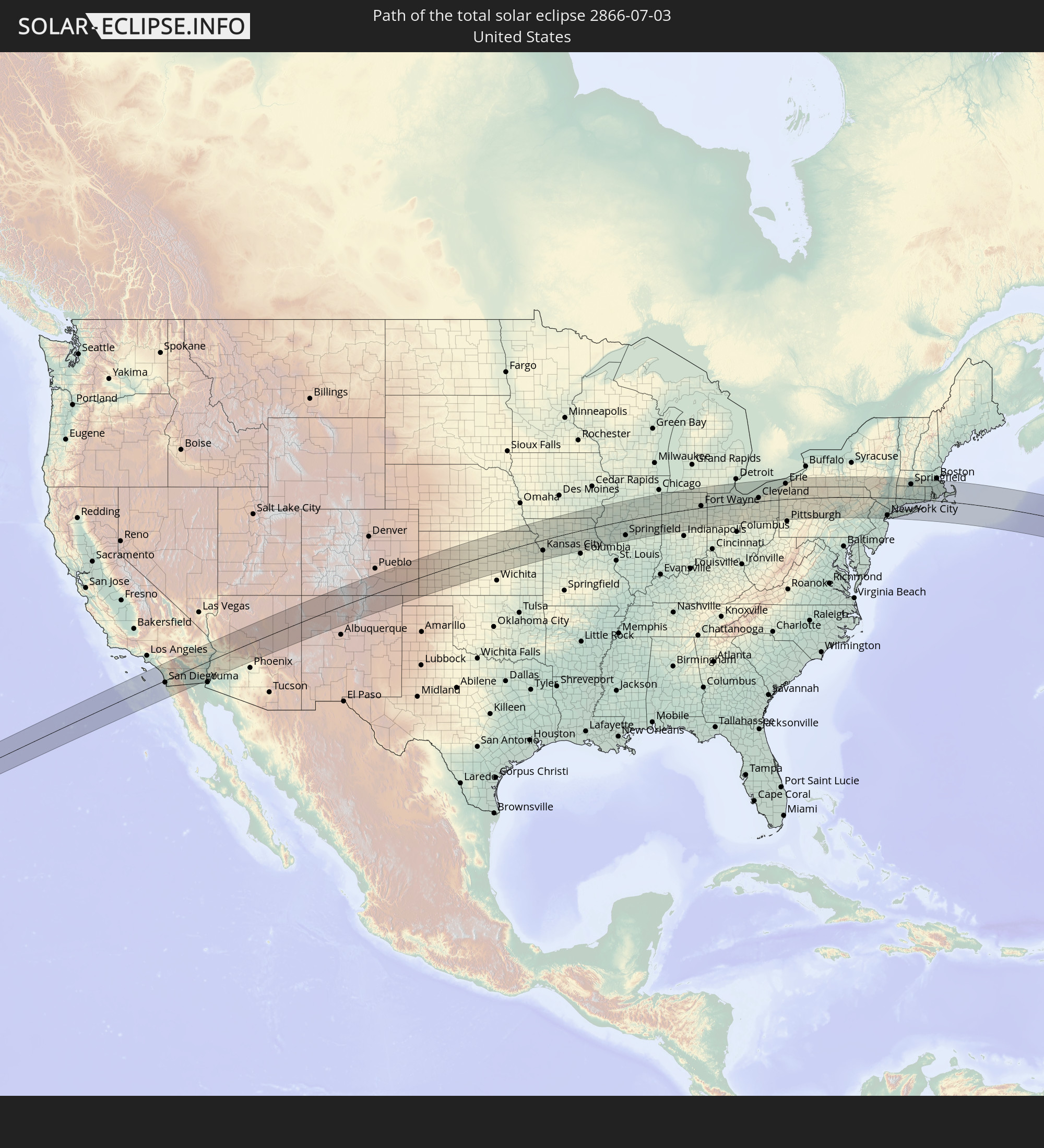 United States
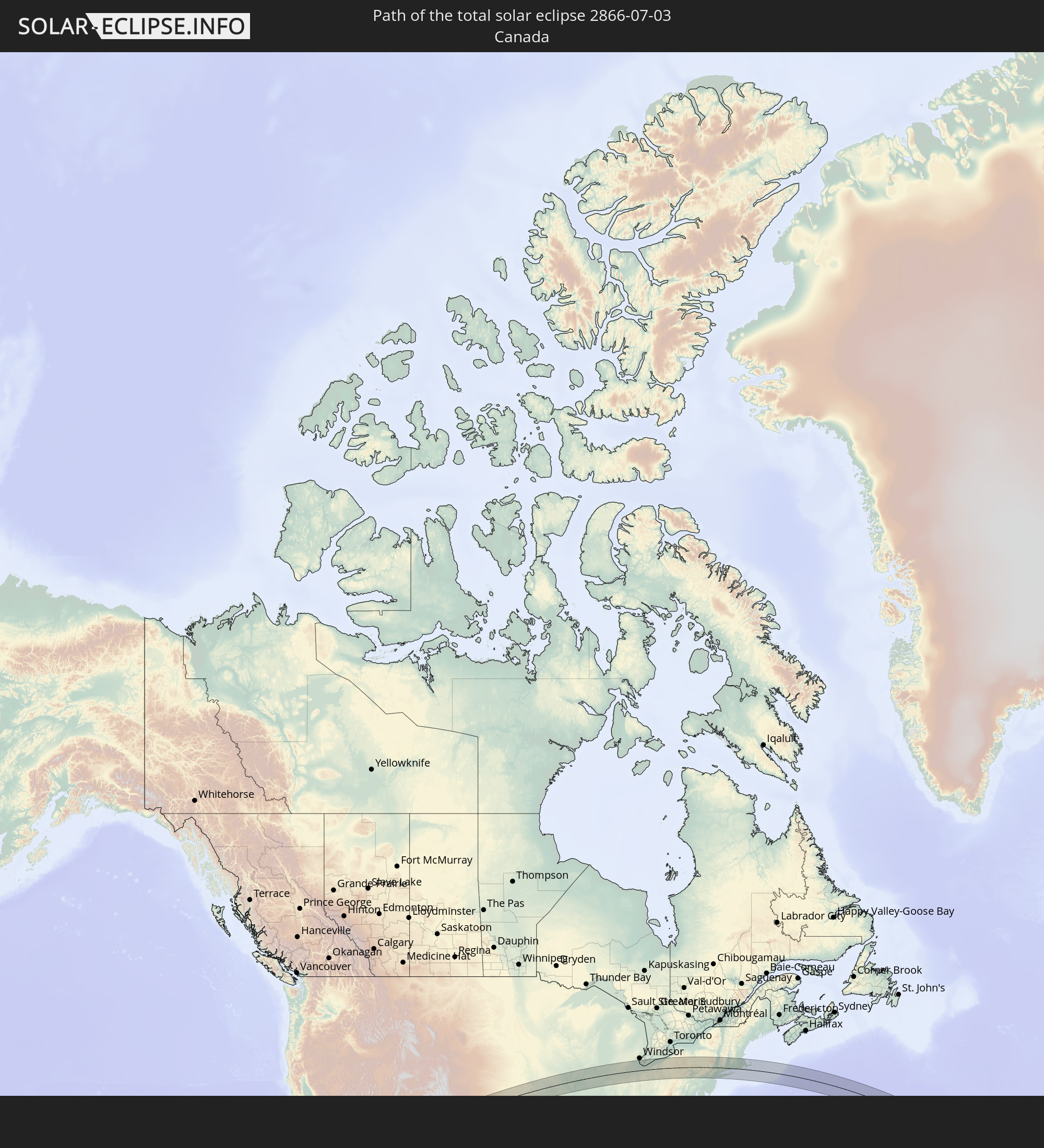 Canada
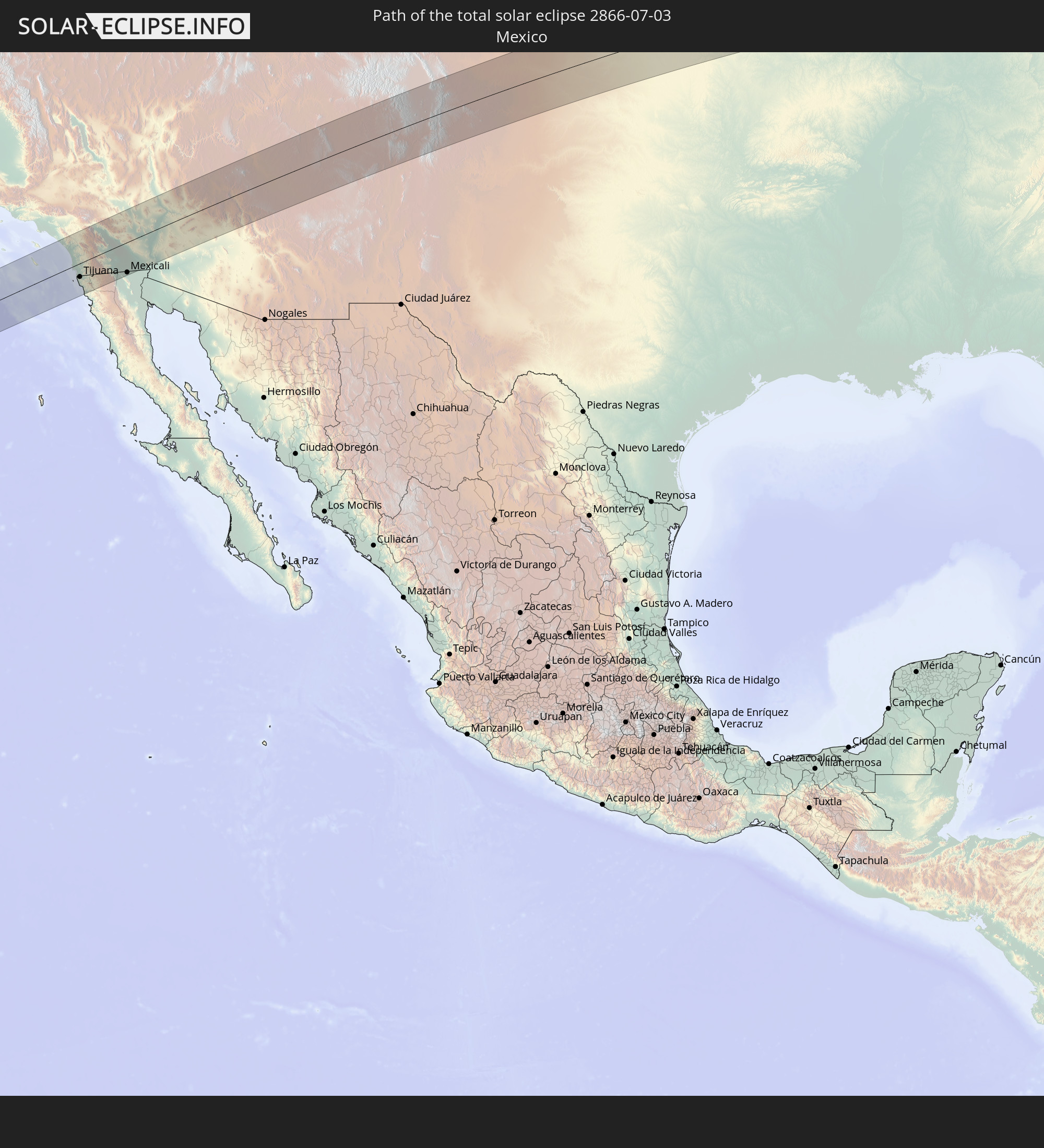 Mexico
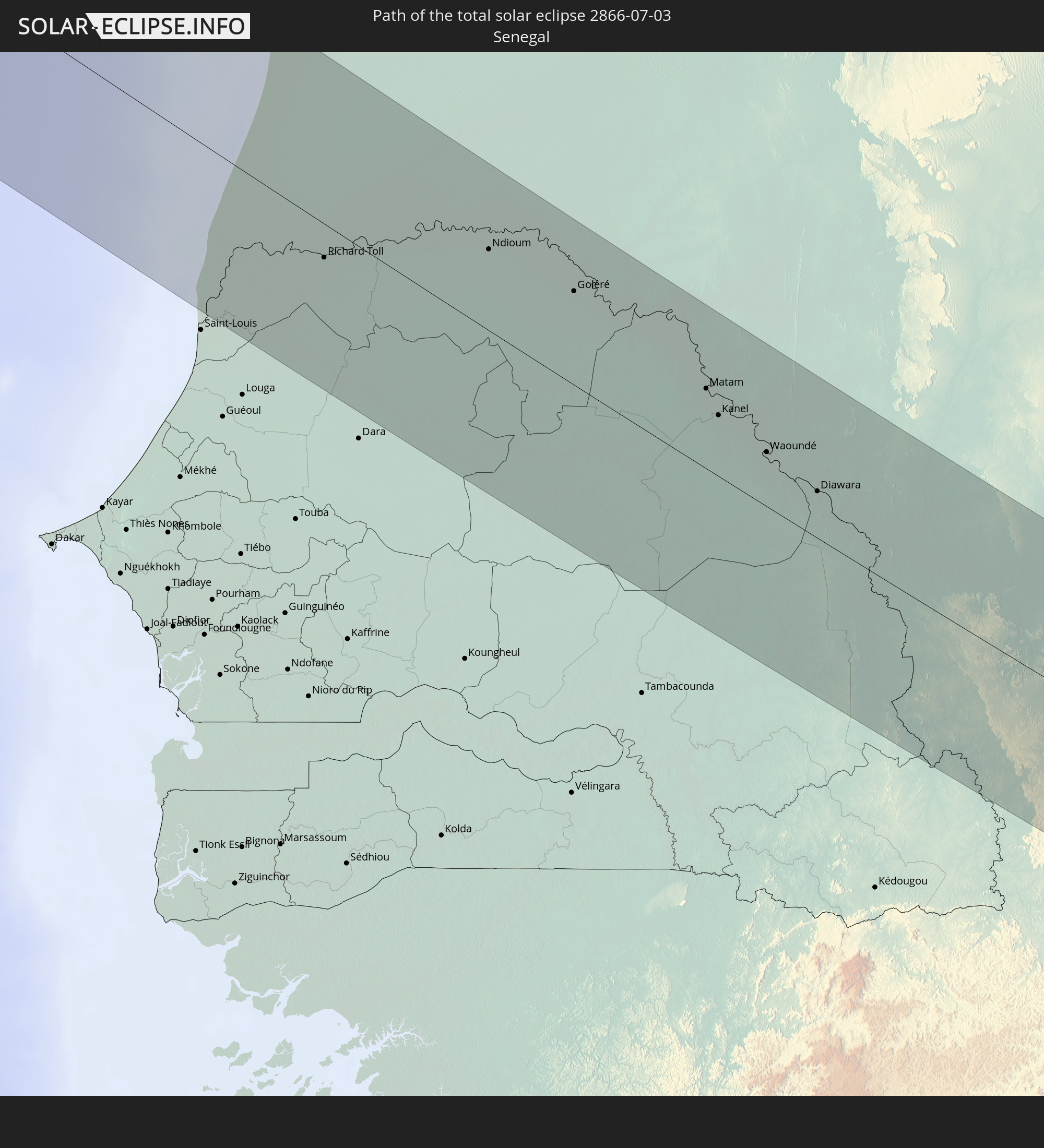 Senegal
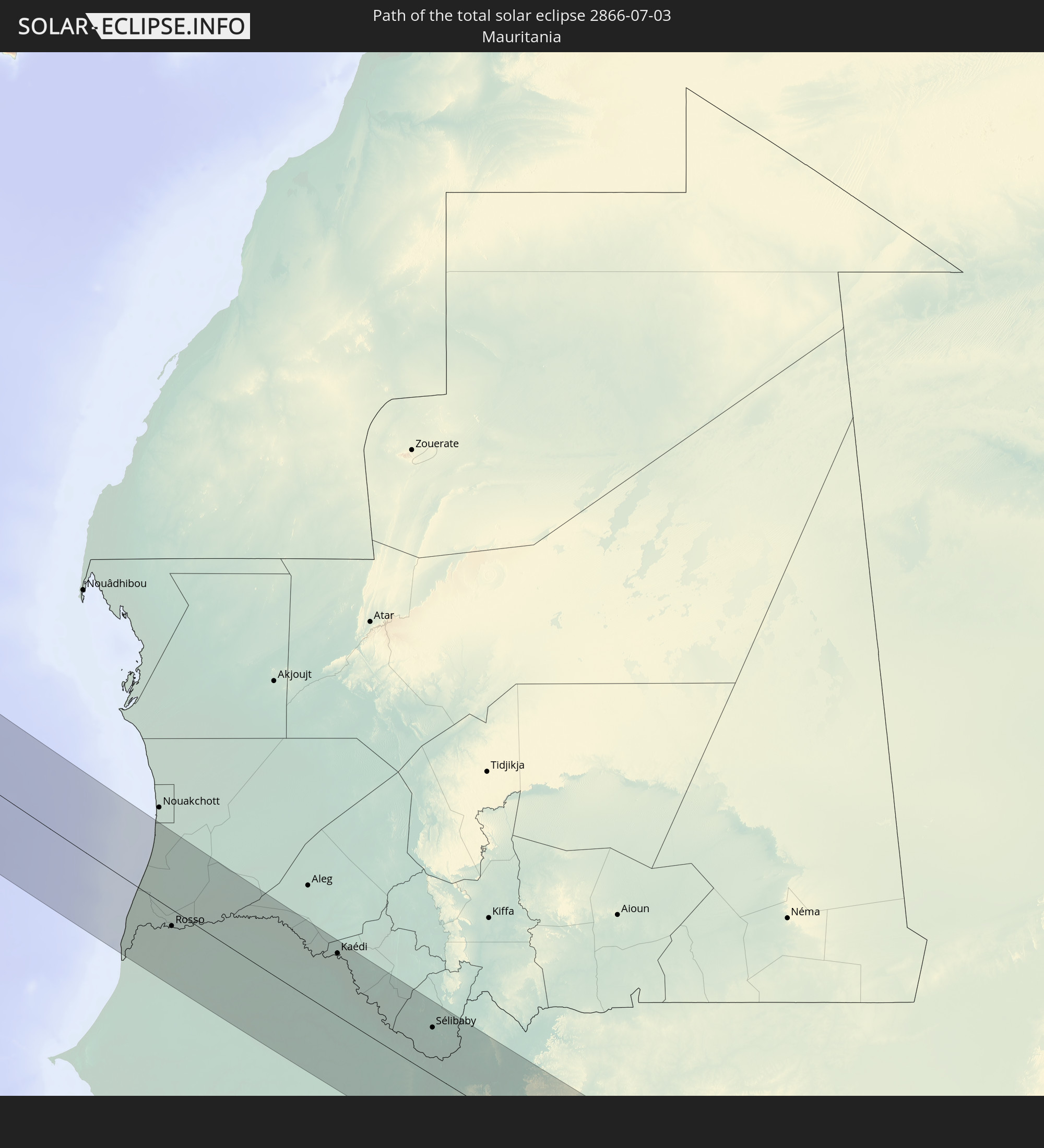 Mauritania
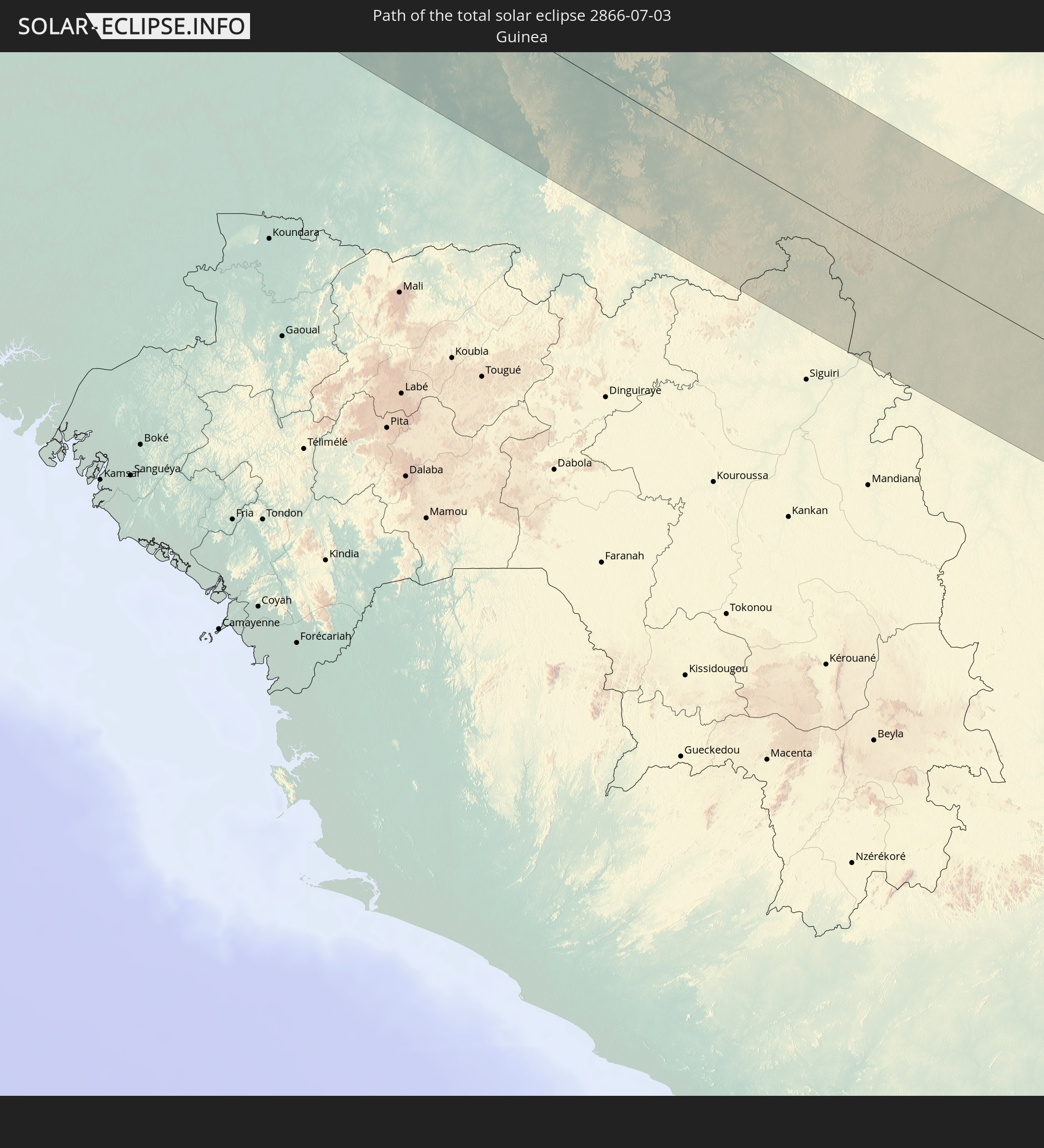 Guinea
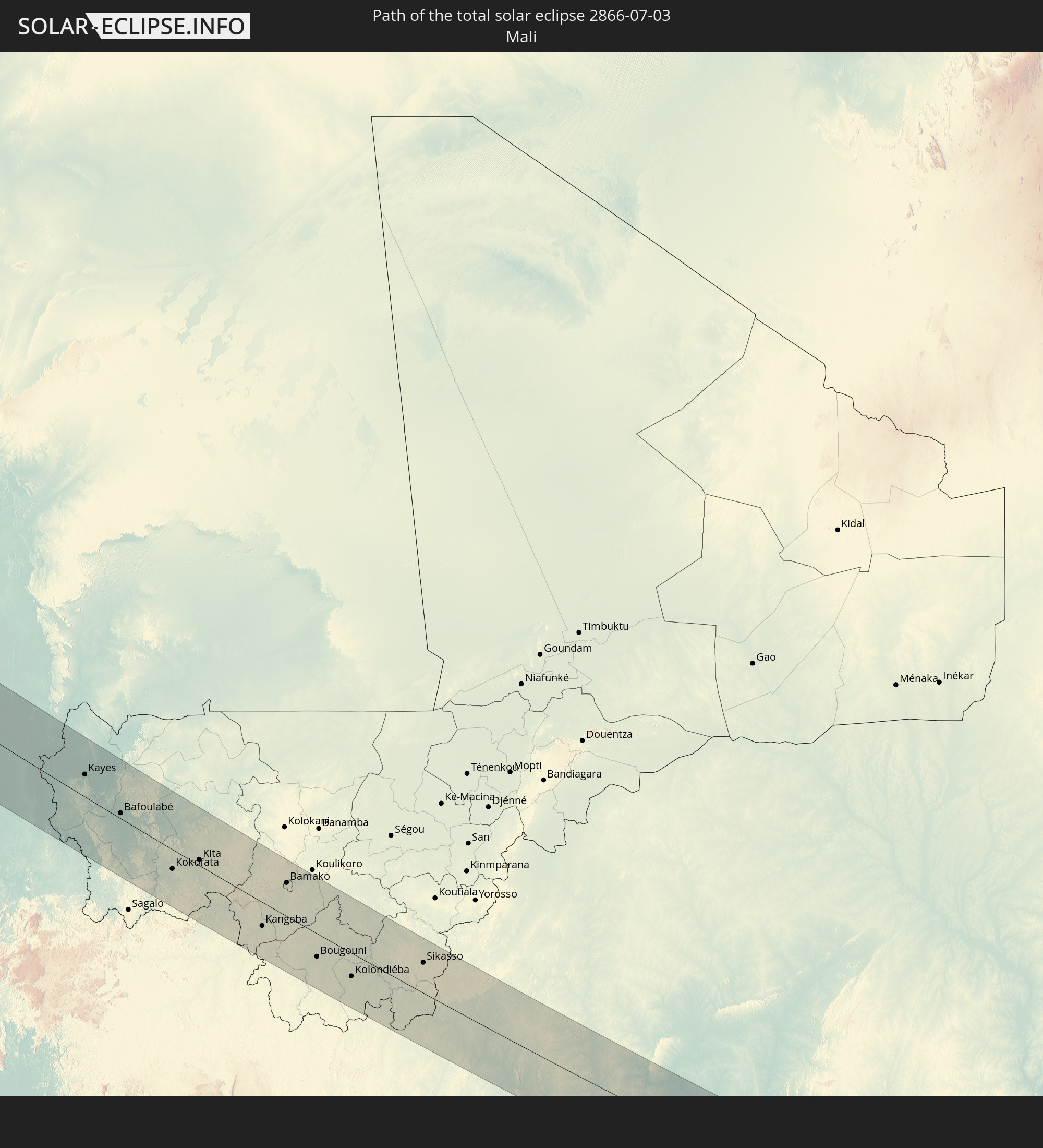 Mali
Mali
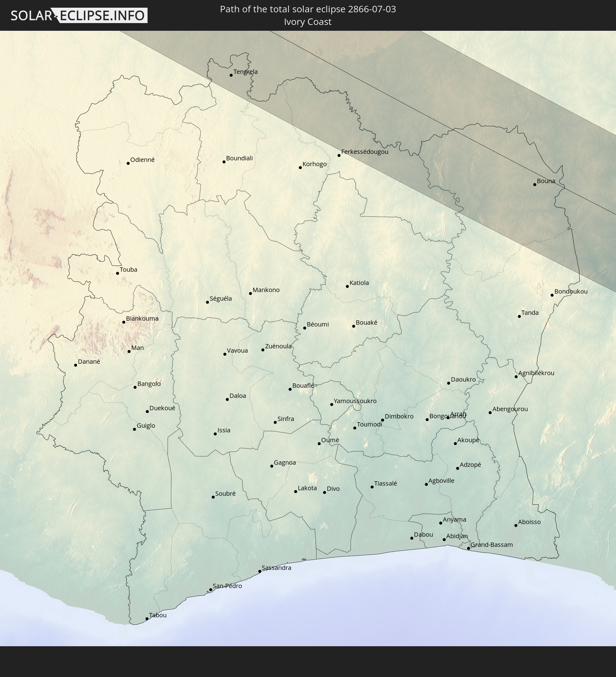 Ivory Coast
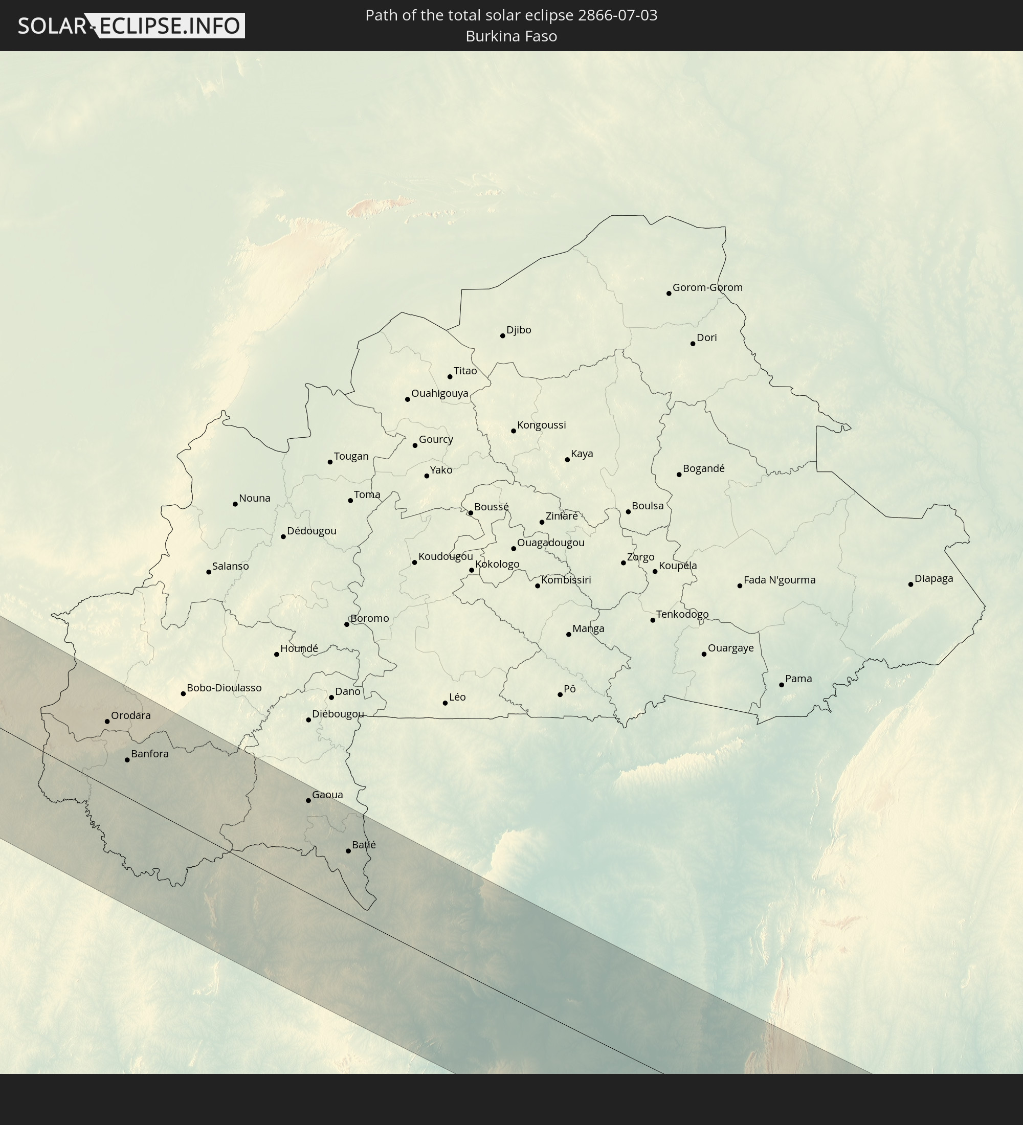 Burkina Faso
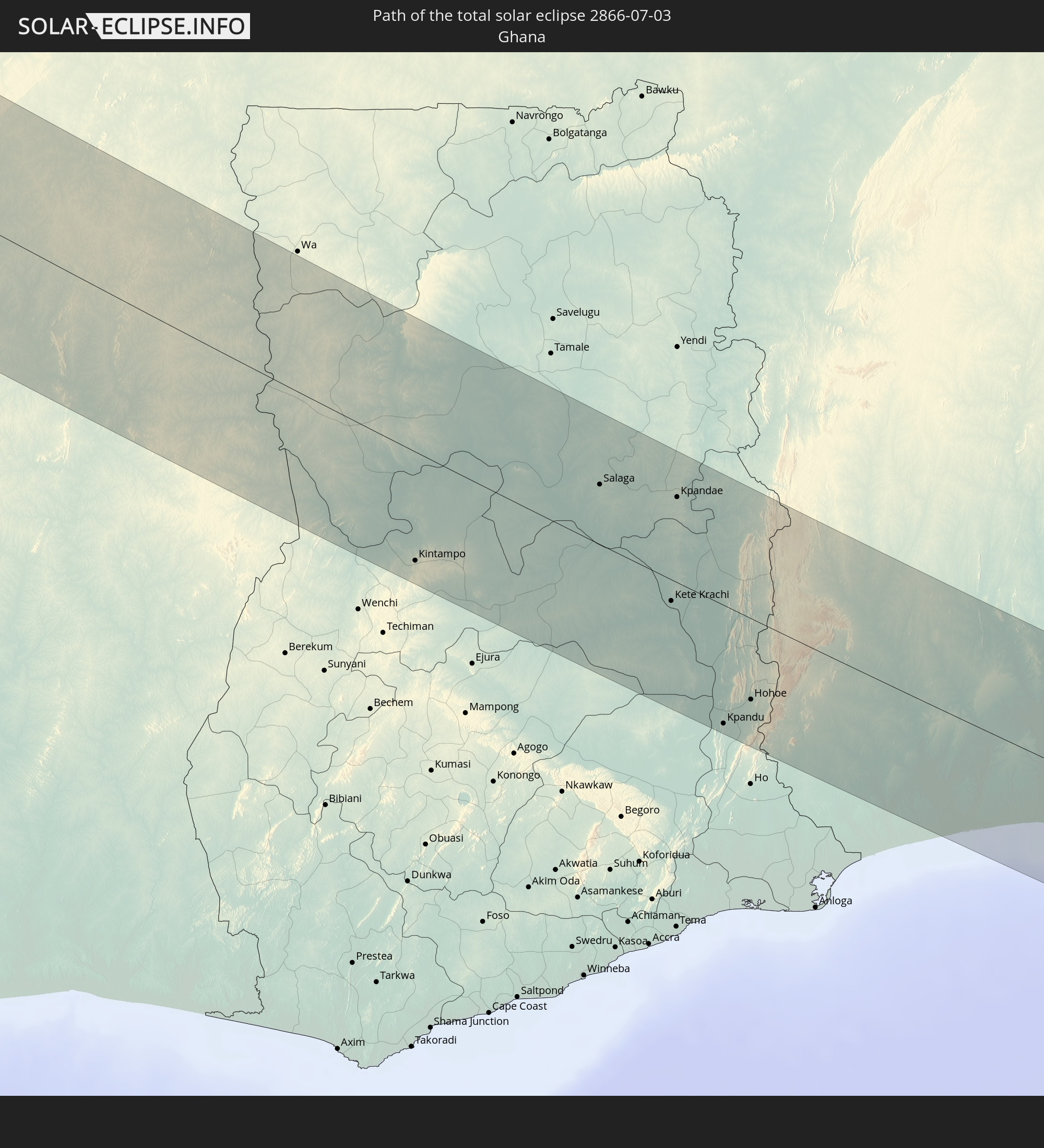 Ghana
Ghana
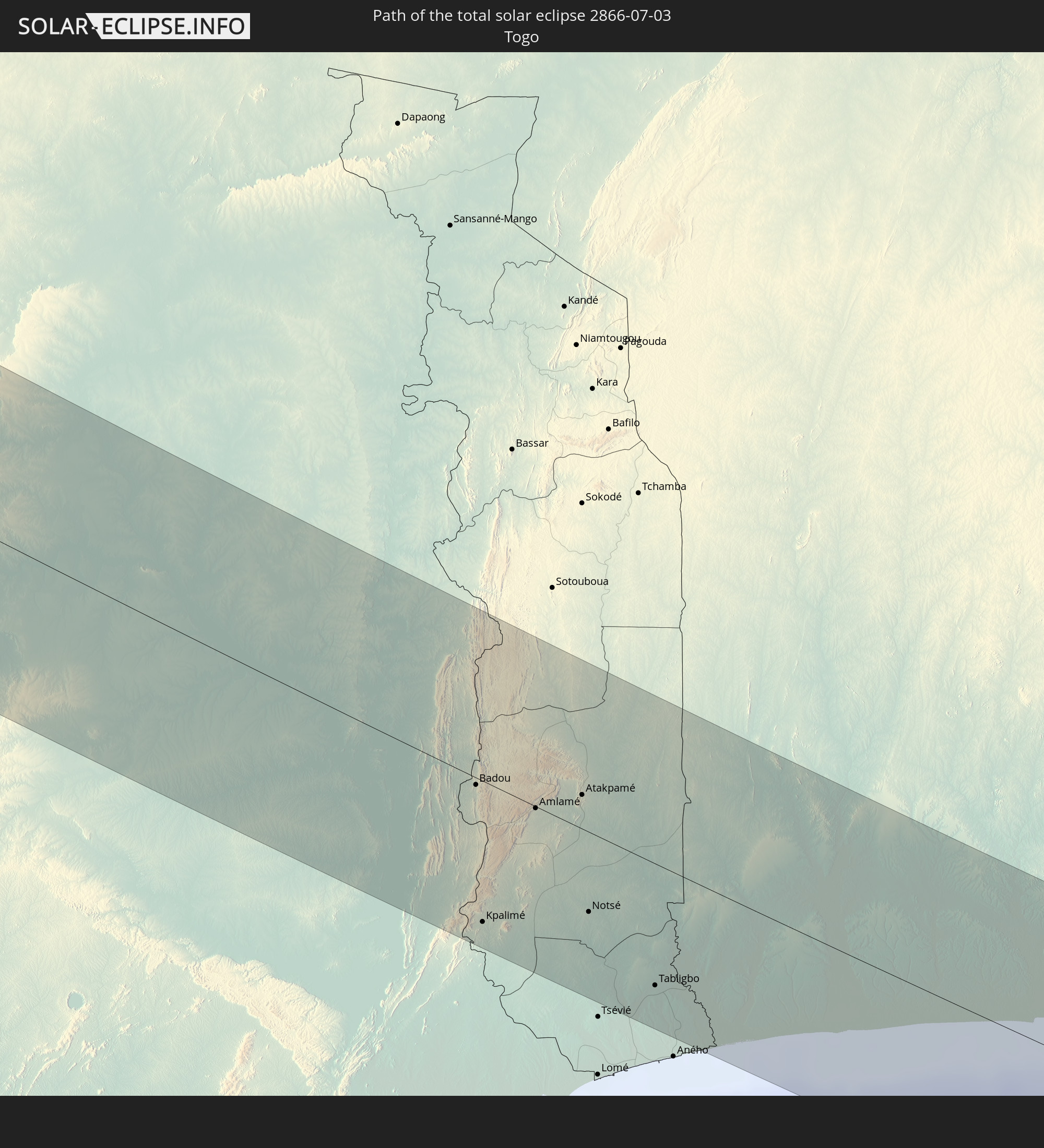 Togo
Togo
 Benin
Benin
 Nigeria
In den folgenden Ländern ist die Sonnenfinsternis partiell zu sehen
 United States
 United States Minor Outlying Islands
 Canada
 Mexico
 Greenland
 Guatemala
 El Salvador
 Honduras
 Belize
 Nicaragua
 Costa Rica
 Cuba
Cuba
 Colombia
 Cayman Islands
 The Bahamas
 Jamaica
 Haiti
Haiti
 Brazil
 Venezuela
 Turks and Caicos Islands
 Dominican Republic
 Aruba
Aruba
 Puerto Rico
 United States Virgin Islands
 Bermuda
 British Virgin Islands
 Anguilla
 Collectivity of Saint Martin
 Saint Barthélemy
 Saint Kitts and Nevis
 Antigua and Barbuda
 Montserrat
 Trinidad and Tobago
 Guadeloupe
 Grenada
 Dominica
 Saint Vincent and the Grenadines
 Guyana
 Martinique
 Saint Lucia
 Barbados
 Suriname
 Saint Pierre and Miquelon
 French Guiana
 Portugal
 Cabo Verde
 Iceland
 Spain
Spain
 Senegal
 Mauritania
 The Gambia
 Guinea-Bissau
 Guinea
 Saint Helena, Ascension and Tristan da Cunha
 Sierra Leone
 Morocco
 Mali
Mali
 Liberia
 Republic of Ireland
 Algeria
 United Kingdom
 Ivory Coast
 Faroe Islands
 Burkina Faso
 Gibraltar
 France
 Isle of Man
 Ghana
Ghana
 Guernsey
 Jersey
 Togo
Togo
 Niger
Niger
 Benin
Benin
 Andorra
 Belgium
 Nigeria
 Netherlands
 Norway
 Luxembourg
 Germany
 Switzerland
 Italy
Italy
 Monaco
 Tunisia
 Denmark
 Libya
Libya
 Liechtenstein
 Austria
 Czechia
 San Marino
 Vatican City
 Slovenia
 Chad
Chad
 Croatia
 Poland
 Malta
Malta
 Bosnia and Herzegovina
 Hungary
 Slovakia
 Montenegro
 Serbia
 Albania
 Greece
 Romania
 Republic of Macedonia
 Bulgaria
 Egypt
Egypt
 Turkey
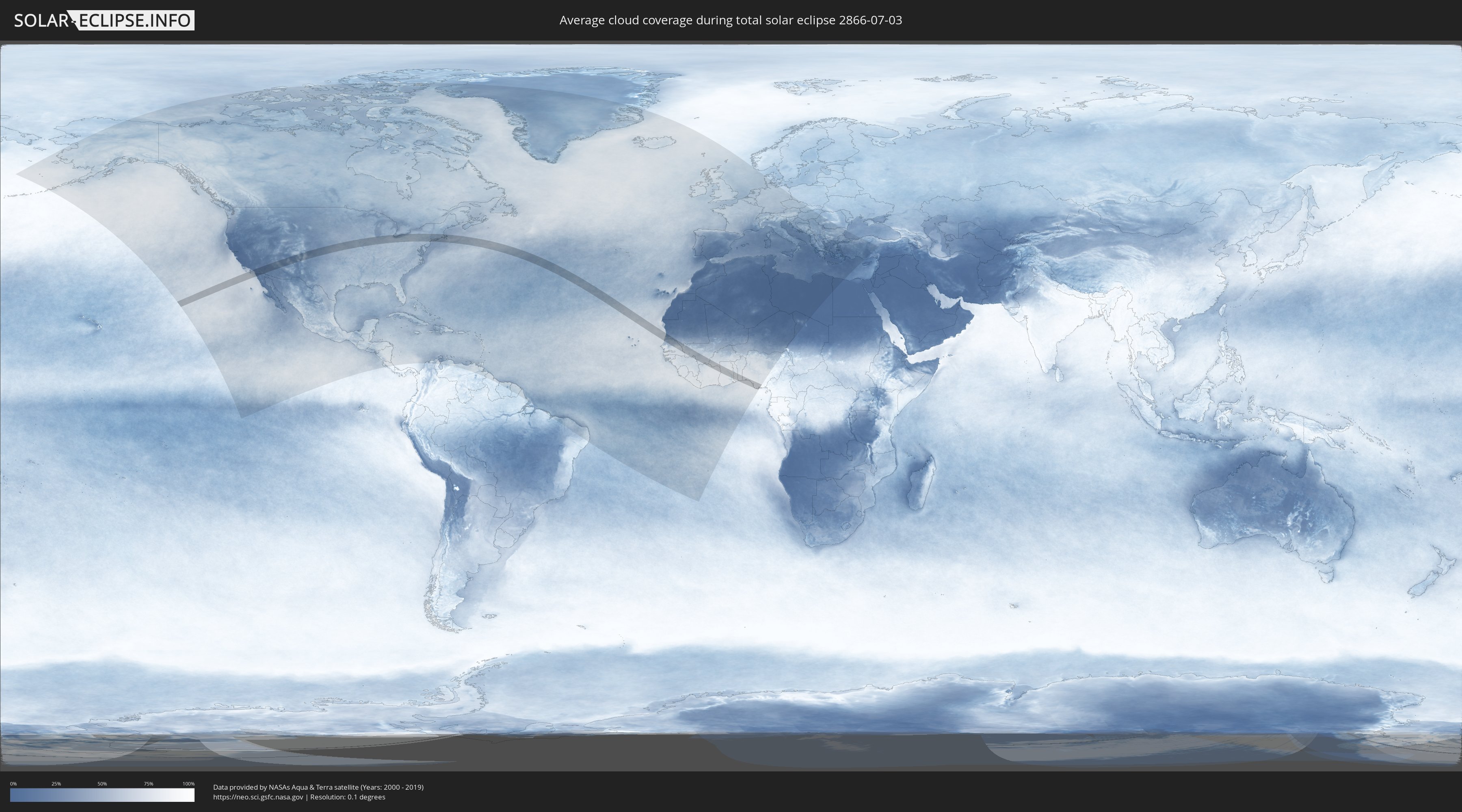
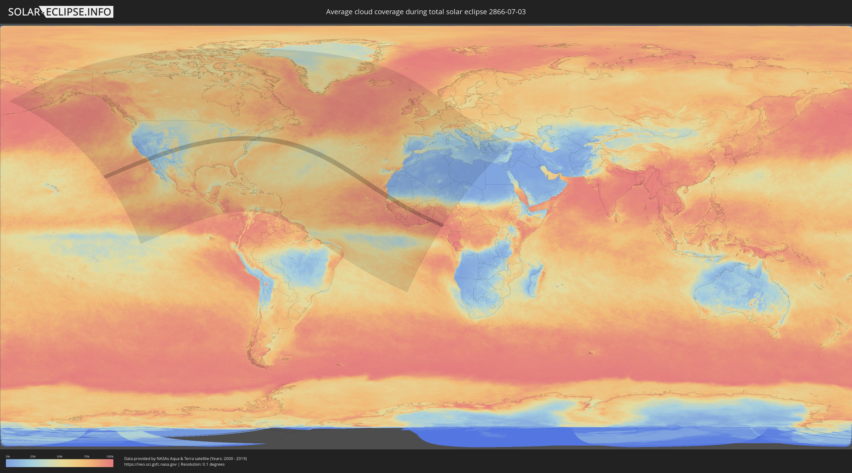
How will be the weather during the total solar eclipse on 07/03/2866?
Where is the best place to see the total solar eclipse of 07/03/2866?
The following maps show the average cloud coverage for the day of the total solar eclipse.
With the help of these maps, it is possible to find the place along the eclipse path, which has the best
chance of a cloudless sky.
Nevertheless, you should consider local circumstances and inform about the weather of your chosen
observation site.
The data is provided by NASAs satellites
AQUA and TERRA.
The cloud maps are averaged over a period of 19 years (2000 - 2019).
Detailed country maps
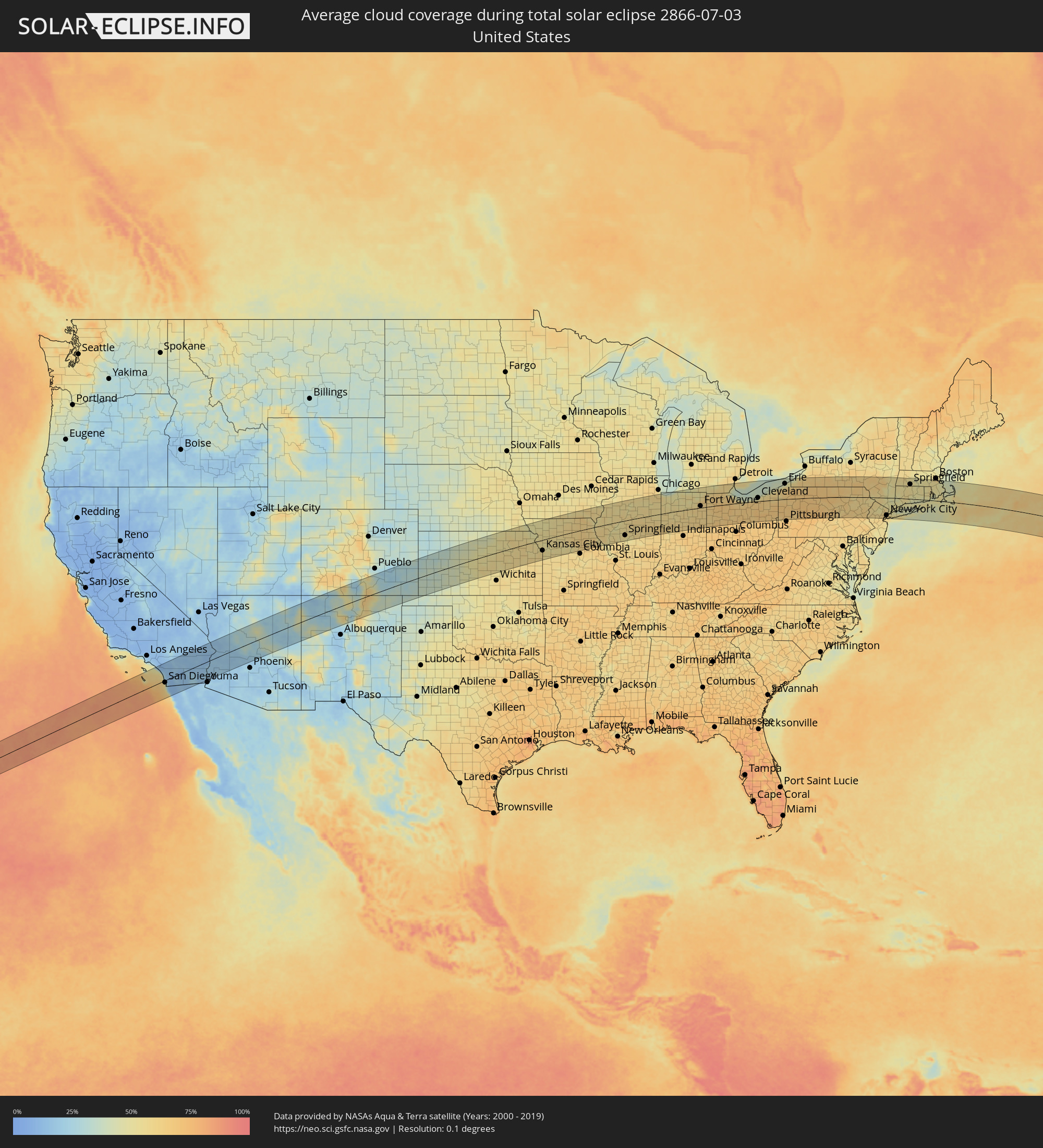 United States
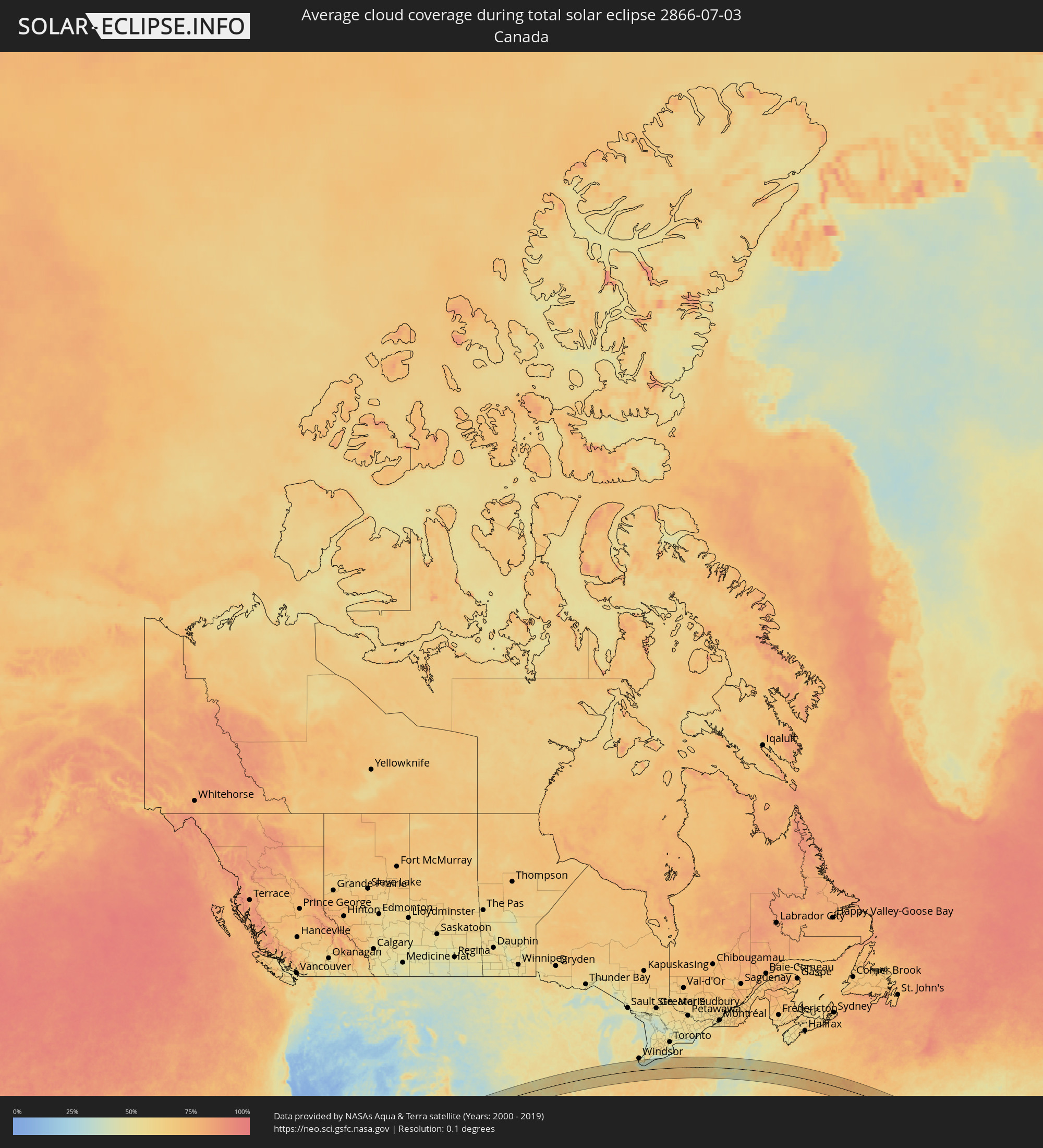 Canada
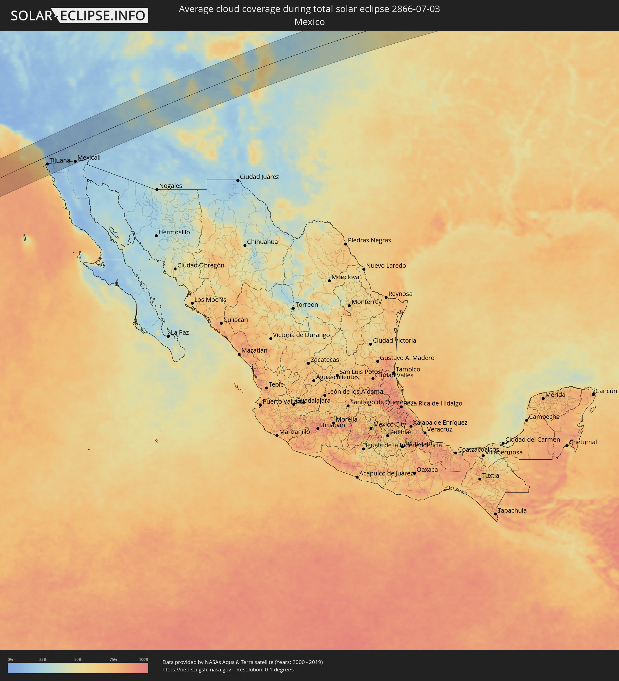 Mexico
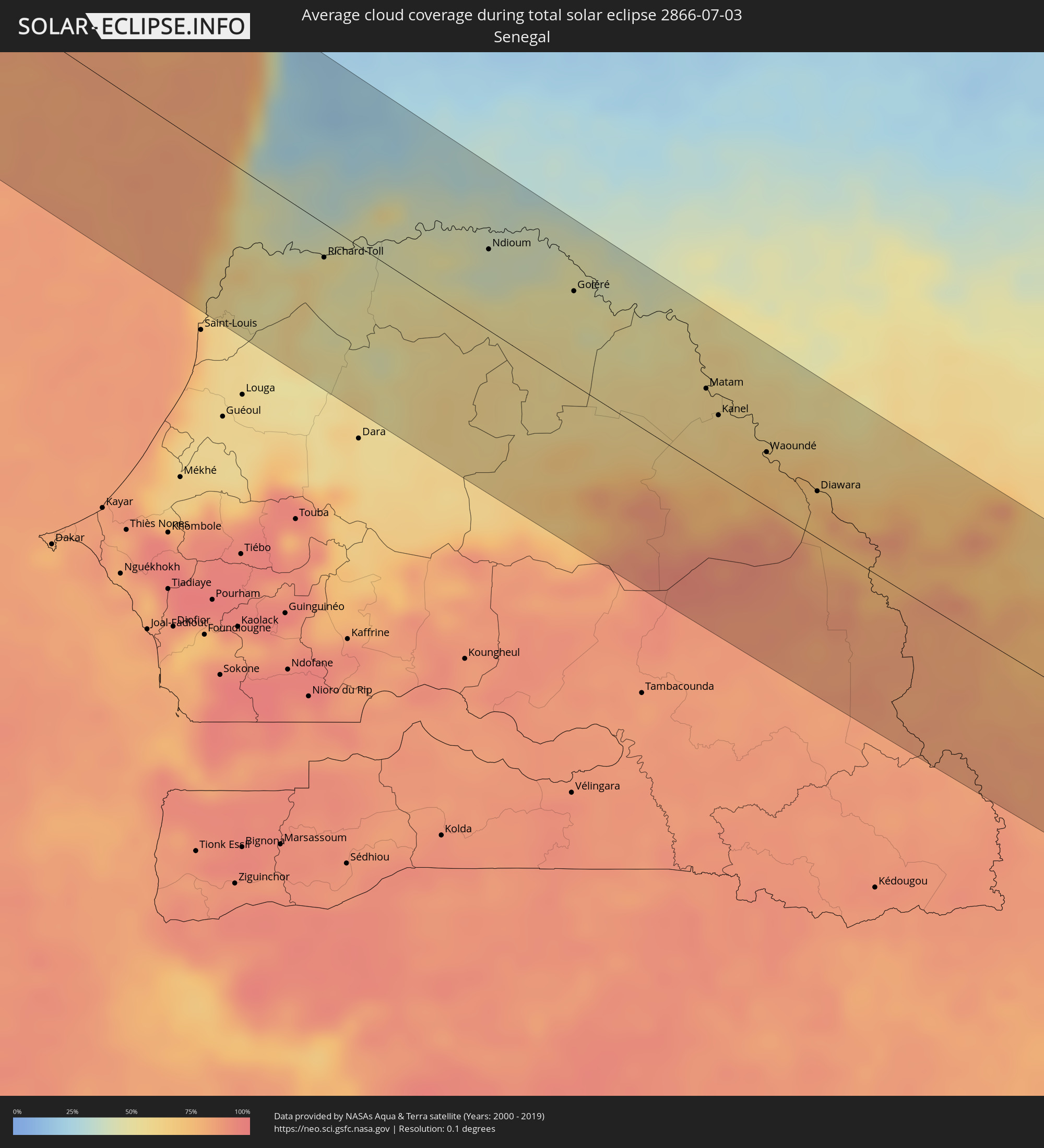 Senegal
 Mauritania
 Guinea
 Mali
Mali
 Ivory Coast
 Burkina Faso
 Ghana
Ghana
 Togo
Togo
 Benin
Benin
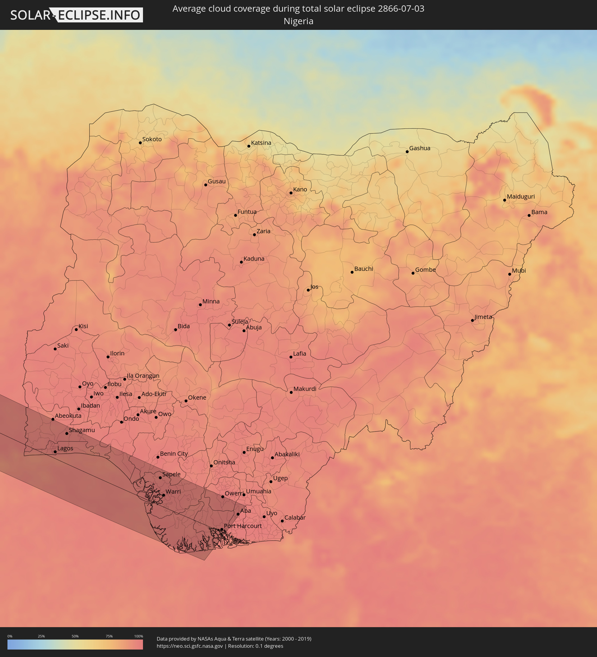 Nigeria
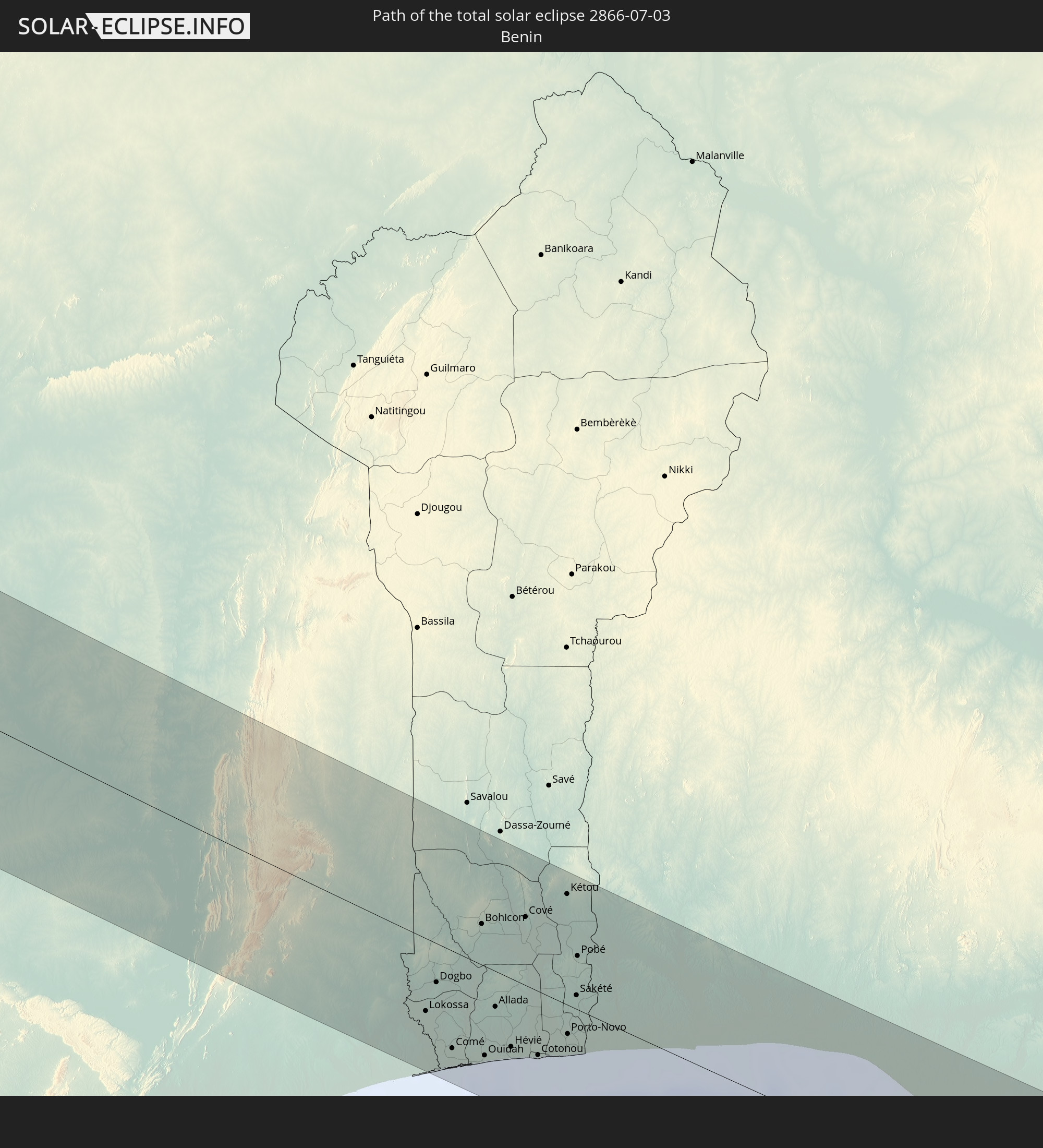
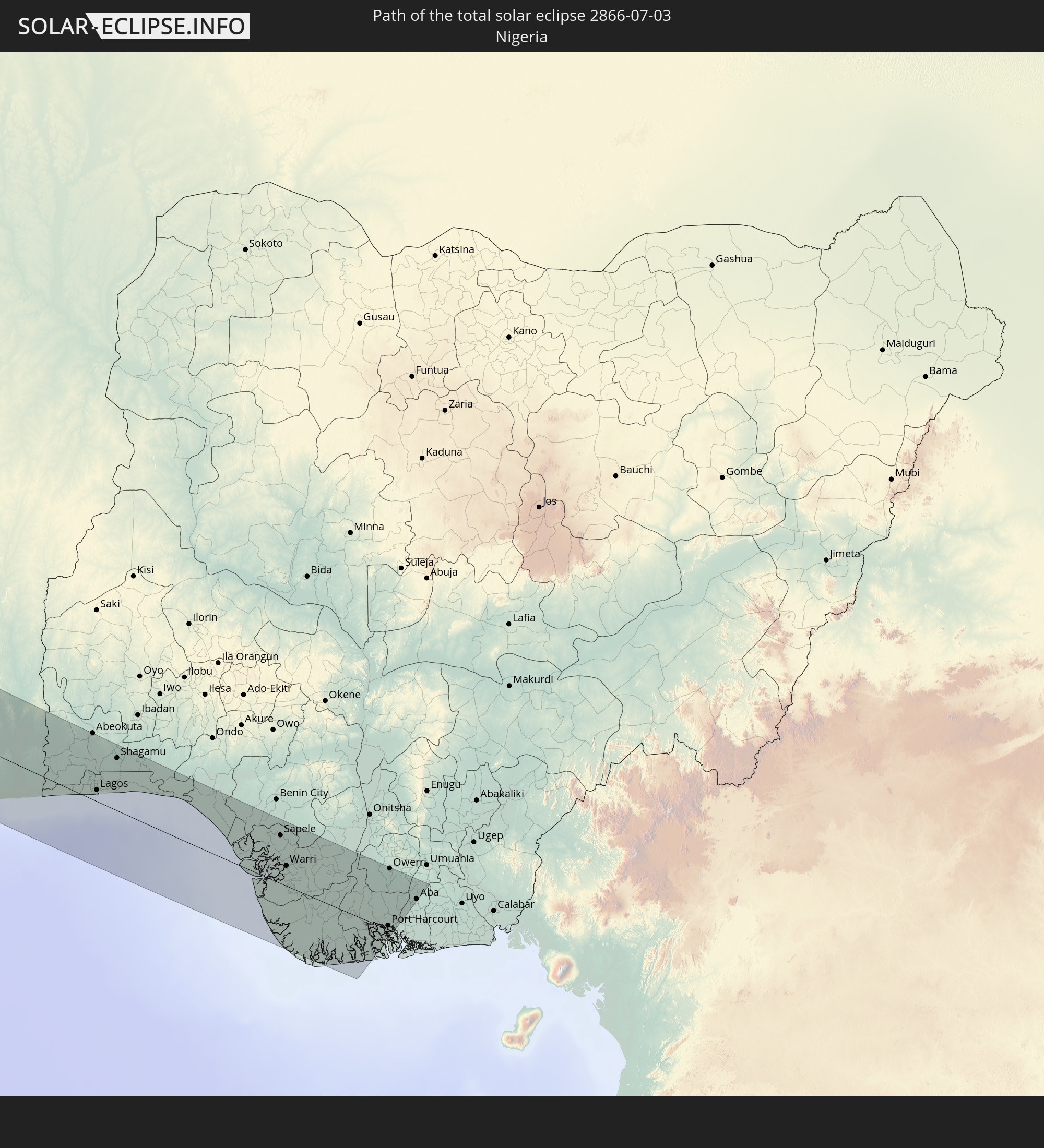
Cities inside the path of the eclipse
The following table shows all locations with a population of more than 5,000 inside the eclipse path. Cities which have more than 100,000 inhabitants are marked bold. A click at the locations opens a detailed map.
| City | Type | Eclipse duration | Local time of max. eclipse | Distance to central line | Ø Cloud coverage |
|
Oceanside, California
|
total | - | 06:31:25 UTC-08:00 | 46 km | 49% |
|
San Diego, California
|
total | - | 06:31:01 UTC-08:00 | 11 km | 53% |
|
Quinta del Cedro, Baja California
|
total | - | 06:30:46 UTC-08:00 | 43 km | 54% |
|
Rosarito, Baja California
|
total | - | 06:30:42 UTC-08:00 | 51 km | 29% |
|
Pórticos de San Antonio, Baja California
|
total | - | 06:30:47 UTC-08:00 | 43 km | 29% |
|
Tijuana, Baja California
|
total | - | 06:30:51 UTC-08:00 | 38 km | 20% |
|
Villa del Prado 2da Sección, Baja California
|
total | - | 06:30:47 UTC-08:00 | 48 km | 29% |
|
San Luis, Baja California
|
total | - | 06:30:48 UTC-08:00 | 47 km | 29% |
|
Las Delicias, Baja California
|
total | - | 06:30:47 UTC-08:00 | 50 km | 15% |
|
Primo Tapia, Baja California
|
total | - | 06:30:37 UTC-08:00 | 70 km | 45% |
|
Terrazas del Valle, Baja California
|
total | - | 06:30:54 UTC-08:00 | 47 km | 11% |
|
Maclovio Rojas, Baja California
|
total | - | 06:30:53 UTC-08:00 | 49 km | 11% |
|
El Niño, Baja California
|
total | - | 06:30:55 UTC-08:00 | 46 km | 11% |
|
Villa del Campo, Baja California
|
total | - | 06:30:56 UTC-08:00 | 48 km | 11% |
|
Lomas de Santa Anita, Baja California
|
total | - | 06:31:00 UTC-08:00 | 48 km | 11% |
|
Tecate, Baja California
|
total | - | 06:31:02 UTC-08:00 | 46 km | 11% |
|
Progreso, Baja California
|
total | - | 06:31:23 UTC-08:00 | 85 km | 16% |
|
Mexicali, Baja California
|
total | - | 06:31:29 UTC-08:00 | 85 km | 17% |
|
Overland Park, Kansas
|
total | - | 08:53:37 UTC-06:00 | 63 km | 58% |
|
Kansas City, Missouri
|
total | - | 08:53:50 UTC-06:00 | 53 km | 56% |
|
Joliet, Illinois
|
total | - | 09:04:20 UTC-06:00 | 91 km | 57% |
|
Fort Wayne, Indiana
|
total | - | 10:08:19 UTC-05:00 | 9 km | 59% |
|
Toledo, Ohio
|
total | - | 10:11:06 UTC-05:00 | 51 km | 61% |
|
Amherstburg, Ontario
|
total | - | 10:12:11 UTC-05:00 | 96 km | 49% |
|
Cleveland, Ohio
|
total | - | 10:13:58 UTC-05:00 | 17 km | 57% |
|
Akron, Ohio
|
total | - | 10:14:01 UTC-05:00 | 31 km | 67% |
|
Paterson, New Jersey
|
total | - | 10:27:01 UTC-05:00 | 66 km | 61% |
|
New York City, New York
|
total | - | 10:27:17 UTC-05:00 | 88 km | 58% |
|
The Bronx, New York
|
total | - | 10:27:35 UTC-05:00 | 72 km | 58% |
|
Jamaica, New York
|
total | - | 10:27:40 UTC-05:00 | 90 km | 54% |
|
Bridgeport, Connecticut
|
total | - | 10:28:53 UTC-05:00 | 34 km | 48% |
|
Springfield, Massachusetts
|
total | - | 10:30:10 UTC-05:00 | 72 km | 53% |
|
Worcester, Massachusetts
|
total | - | 10:31:39 UTC-05:00 | 94 km | 53% |
|
Providence, Rhode Island
|
total | - | 10:32:21 UTC-05:00 | 48 km | 55% |
|
Rosso, Trarza
|
total | - | 17:33:02 UTC+00:00 | 21 km | 58% |
|
Rosso, Saint-Louis
|
total | - | 17:33:09 UTC+00:00 | 29 km | 58% |
|
Richard-Toll, Saint-Louis
|
total | - | 17:33:08 UTC+00:00 | 19 km | 54% |
|
Tékane, Trarza
|
total | - | 17:33:06 UTC+00:00 | 6 km | 49% |
|
Ndioum, Saint-Louis
|
total | - | 17:33:33 UTC+00:00 | 47 km | 39% |
|
Goléré, Saint-Louis
|
total | - | 17:34:06 UTC+00:00 | 54 km | 50% |
|
Kaédi, Gorgol
|
total | - | 17:34:28 UTC+00:00 | 79 km | 52% |
|
Ouro Sogui, Matam
|
total | - | 17:35:12 UTC+00:00 | 38 km | 59% |
|
Matam, Matam
|
total | - | 17:35:10 UTC+00:00 | 46 km | 58% |
|
Kanel, Matam
|
total | - | 17:35:23 UTC+00:00 | 36 km | 61% |
|
Sémé, Matam
|
total | - | 17:35:50 UTC+00:00 | 21 km | 74% |
|
Waoundé, Matam
|
total | - | 17:35:46 UTC+00:00 | 32 km | 73% |
|
Diawara, Matam
|
total | - | 17:36:10 UTC+00:00 | 27 km | 74% |
|
Sélibaby, Guidimaka
|
total | - | 17:36:08 UTC+00:00 | 61 km | 67% |
|
Kayes, Kayes
|
total | - | 17:37:12 UTC+00:00 | 35 km | 77% |
|
Bafoulabé, Kayes
|
total | - | 17:38:06 UTC+00:00 | 9 km | 80% |
|
Kokofata
|
total | - | 17:39:21 UTC+00:00 | 31 km | 86% |
|
Kita, Kayes
|
total | - | 17:39:17 UTC+00:00 | 9 km | 81% |
|
Kangaba, Koulikoro
|
total | - | 17:40:40 UTC+00:00 | 38 km | 79% |
|
Kati, Koulikoro
|
total | - | 17:39:53 UTC+00:00 | 59 km | 70% |
|
Bamako, Bamako
|
total | - | 17:39:59 UTC+00:00 | 54 km | 70% |
|
Bougouni, Sikasso
|
total | - | 17:41:21 UTC+00:00 | 38 km | 84% |
|
Kolondiéba, Sikasso
|
total | - | 17:41:46 UTC+00:00 | 38 km | 85% |
|
Tengrela, Savanes
|
total | - | 17:42:25 UTC+00:00 | 71 km | 87% |
|
Sikasso, Sikasso
|
total | - | 17:41:40 UTC+00:00 | 49 km | 85% |
|
Orodara, Hauts-Bassins
|
total | - | 17:42:05 UTC+00:00 | 52 km | 86% |
|
Banfora, Cascades
|
total | - | 17:42:24 UTC+00:00 | 30 km | 92% |
|
Gaoua, Sud-Ouest
|
total | - | 17:42:46 UTC+00:00 | 75 km | 91% |
|
Bouna, Zanzan
|
total | - | 17:43:43 UTC+00:00 | 13 km | 94% |
|
Batié, Sud-Ouest
|
total | - | 17:43:10 UTC+00:00 | 51 km | 94% |
|
Kintampo, Brong-Ahafo
|
total | - | 17:44:45 UTC+00:00 | 70 km | 93% |
|
Salaga, Northern
|
total | - | 17:44:15 UTC+00:00 | 39 km | 94% |
|
Kete Krachi
|
total | - | 17:44:51 UTC+00:00 | 14 km | 81% |
|
Kpandae
|
total | - | 17:44:17 UTC+00:00 | 55 km | 94% |
|
Kpandu, Volta
|
total | - | 17:45:28 UTC+00:00 | 77 km | 90% |
|
Hohoe, Volta
|
total | - | 17:45:20 UTC+00:00 | 53 km | 96% |
|
Badou, Plateaux
|
total | - | 17:44:58 UTC+00:00 | 4 km | 97% |
|
Kpalimé, Plateaux
|
total | - | 17:45:31 UTC+00:00 | 70 km | 94% |
|
Amlamé, Plateaux
|
total | - | 17:45:01 UTC+00:00 | 1 km | 93% |
|
Atakpamé, Plateaux
|
total | - | 17:44:56 UTC+00:00 | 17 km | 92% |
|
Notsé, Plateaux
|
total | - | 17:45:24 UTC+00:00 | 40 km | 94% |
|
Tabligbo, Maritime
|
total | - | 17:45:39 UTC+00:00 | 61 km | 96% |
|
Aplahoué, Kouffo
|
total | - | 18:45:21 UTC+01:00 | 17 km | 96% |
|
Lokossa, Mono
|
total | - | 18:45:34 UTC+01:00 | 45 km | 95% |
|
Dogbo, Kouffo
|
total | - | 18:45:25 UTC+01:00 | 24 km | 95% |
|
Grand-Popo, Mono
|
total | - | 18:45:50 UTC+01:00 | 76 km | 88% |
|
Comé, Mono
|
total | - | 18:45:44 UTC+01:00 | 61 km | 91% |
|
Abomey, Zou
|
total | - | 18:45:06 UTC+01:00 | 22 km | 96% |
|
Bohicon, Zou
|
total | - | 18:45:06 UTC+01:00 | 26 km | 96% |
|
Ouidah, Atlantique
|
total | - | 18:45:44 UTC+01:00 | 56 km | 91% |
|
Allada, Atlantique
|
total | - | 18:45:29 UTC+01:00 | 22 km | 97% |
|
Hévié, Atlantique
|
total | - | 18:45:40 UTC+01:00 | 43 km | 93% |
|
Cové, Zou
|
total | - | 18:45:01 UTC+01:00 | 43 km | 95% |
|
Abomey-Calavi, Atlantique
|
total | - | 18:45:37 UTC+01:00 | 34 km | 93% |
|
Cotonou, Littoral
|
total | - | 18:45:40 UTC+01:00 | 40 km | 93% |
|
Kétou, Plateau
|
total | - | 18:44:52 UTC+01:00 | 69 km | 95% |
|
Porto-Novo, Ouémé
|
total | - | 18:45:33 UTC+01:00 | 18 km | 92% |
|
Sakété, Plateau
|
total | - | 18:45:21 UTC+01:00 | 9 km | 97% |
|
Pobé, Plateau
|
total | - | 18:45:10 UTC+01:00 | 34 km | 96% |
|
Badagry, Lagos
|
total | - | 18:45:33 UTC+01:00 | 13 km | 89% |
|
Ilaro, Ogun
|
total | - | 18:45:10 UTC+01:00 | 41 km | 96% |
|
Ifo, Ogun
|
total | - | 18:45:12 UTC+01:00 | 42 km | 97% |
|
Ikeja, Lagos
|
total | - | 18:45:20 UTC+01:00 | 26 km | 97% |
|
Lagos, Lagos
|
total | - | 18:45:26 UTC+01:00 | 14 km | 95% |
|
Ebute Ikorodu, Lagos
|
total | - | 18:45:18 UTC+01:00 | 33 km | 94% |
|
Shagamu, Ogun
|
total | - | 18:45:05 UTC+01:00 | 66 km | 96% |
|
Ijebu-Ode, Ogun
|
total | - | 18:45:03 UTC+01:00 | 75 km | 97% |
|
Epe, Lagos
|
total | - | 18:45:13 UTC+01:00 | 54 km | 94% |
|
Sapele, Delta
|
total | - | 18:45:21 UTC+01:00 | 61 km | 97% |
|
Warri, Delta
|
total | - | 18:45:37 UTC+01:00 | 25 km | 97% |
|
Ughelli, Delta
|
total | - | 18:45:34 UTC+01:00 | 34 km | 97% |
|
Yenagoa, Bayelsa
|
total | - | 18:45:53 UTC+01:00 | 12 km | 95% |
|
Buguma, Rivers
|
total | - | 18:45:52 UTC+01:00 | 15 km | 95% |
|
Port Harcourt, Rivers
|
total | - | 18:45:47 UTC+01:00 | 5 km | 96% |
|
Owerri, Imo
|
total | - | 18:45:18 UTC+01:00 | 78 km | 97% |
|
Aba, Abia
|
total | - | 18:45:28 UTC+01:00 | 55 km | 97% |