Totale Sonnenfinsternis vom 02.04.2918
| Wochentag: | Samstag |
| Maximale Dauer der Verfinsterung: | 03m55s |
| Maximale Breite des Finsternispfades: | 233 km |
| Saroszyklus: | 173 |
| Bedeckungsgrad: | 100% |
| Magnitude: | 1.0547 |
| Gamma: | 0.6433 |
Wo kann man die Sonnenfinsternis vom 02.04.2918 sehen?
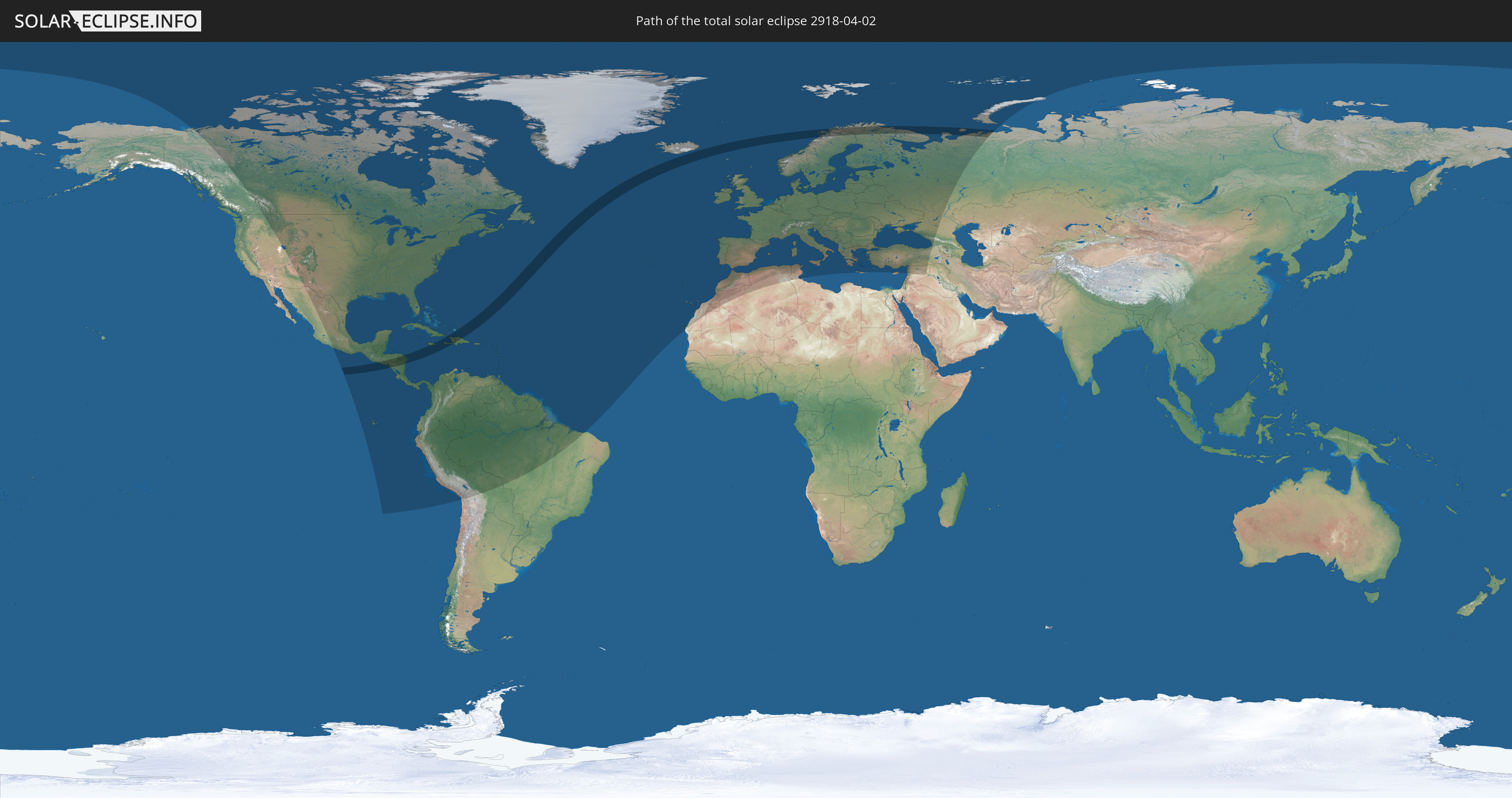
Die Sonnenfinsternis am 02.04.2918 kann man in 109 Ländern als partielle Sonnenfinsternis beobachten.
Der Finsternispfad verläuft durch 13 Länder. Nur in diesen Ländern ist sie als totale Sonnenfinsternis zu sehen.
In den folgenden Ländern ist die Sonnenfinsternis total zu sehen
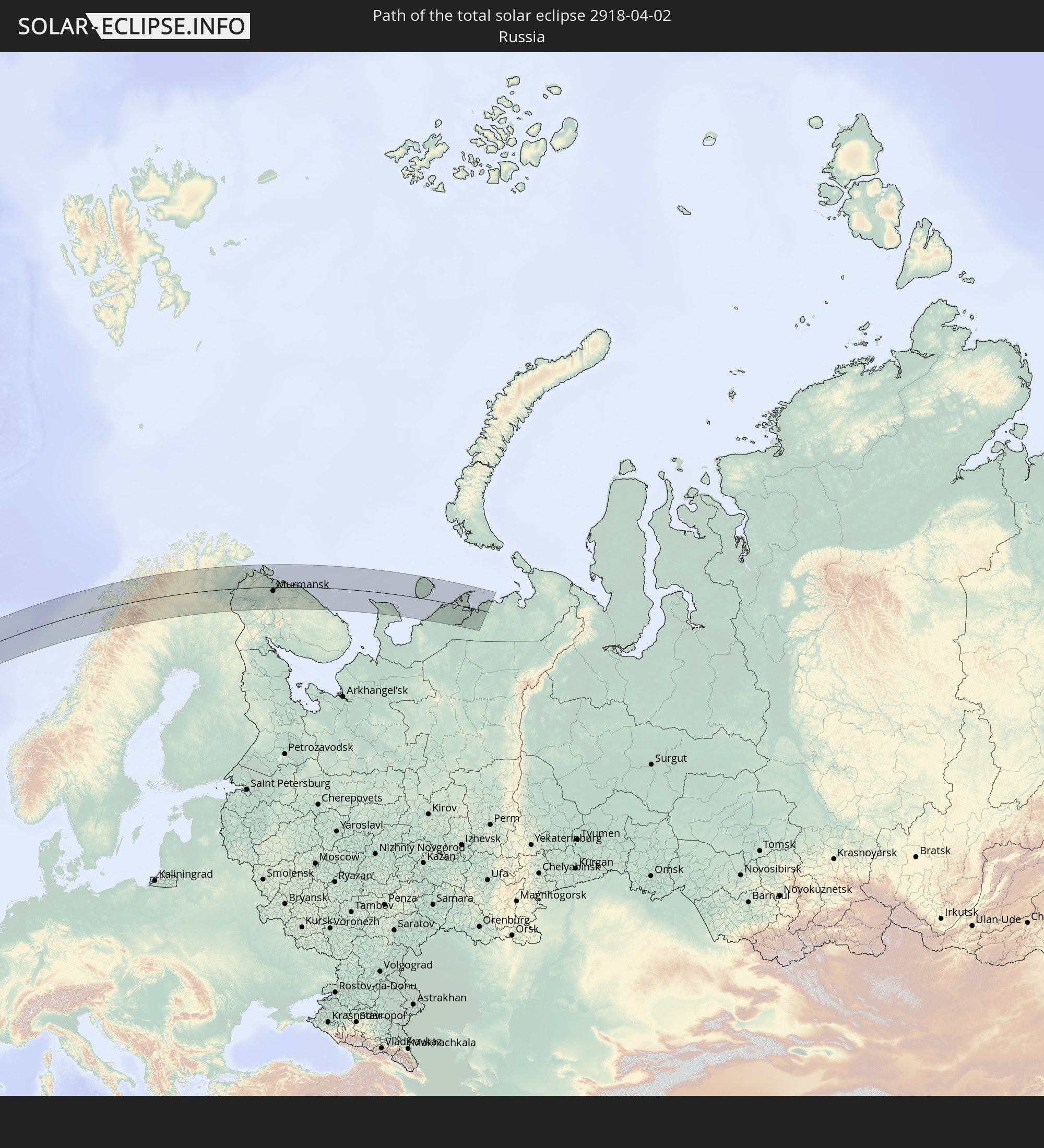 Russland
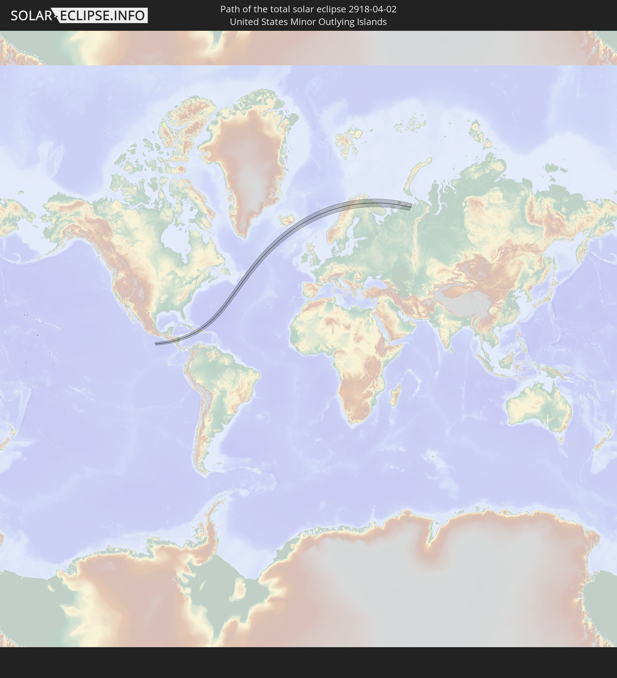 United States Minor Outlying Islands
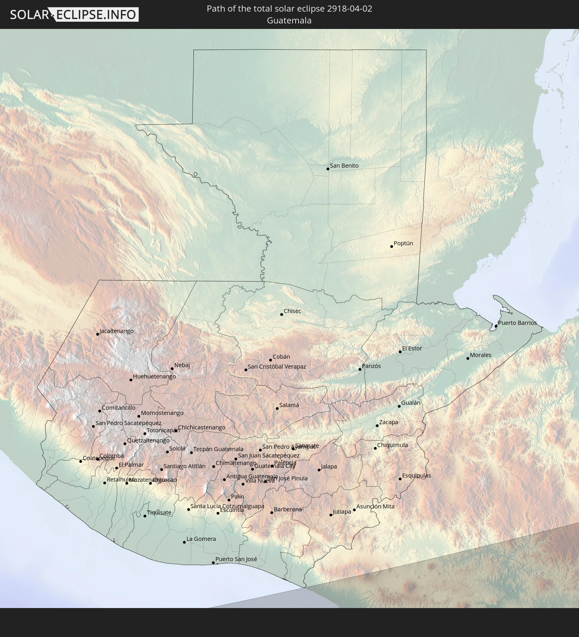 Guatemala
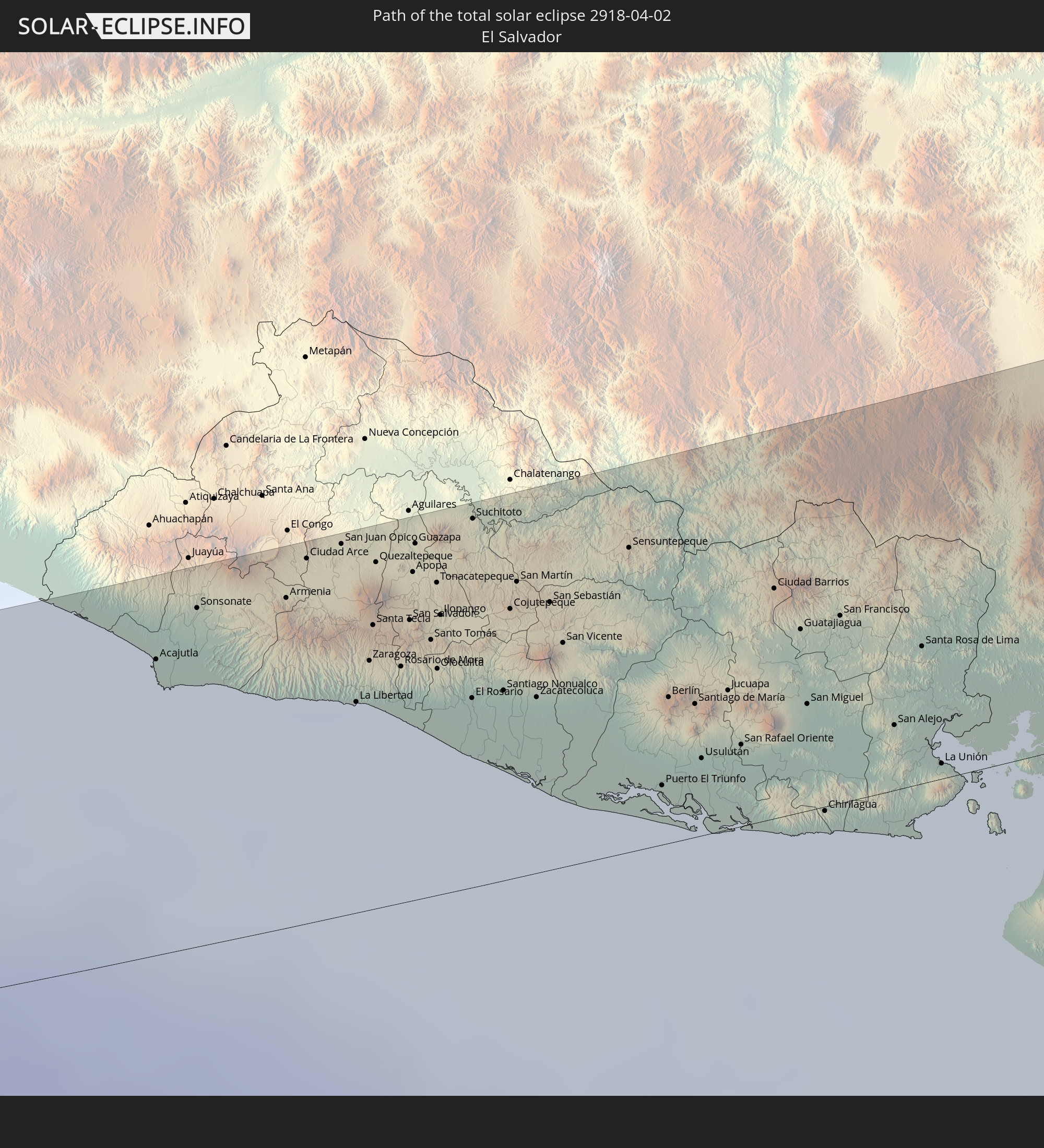 El Salvador
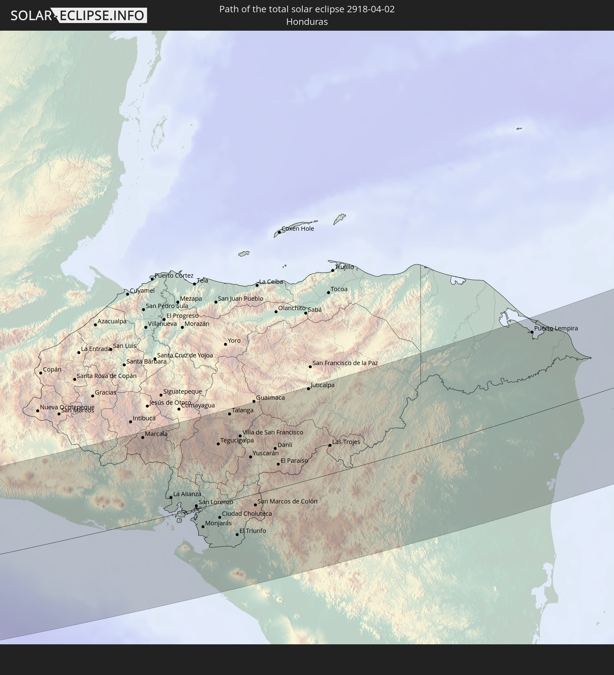 Honduras
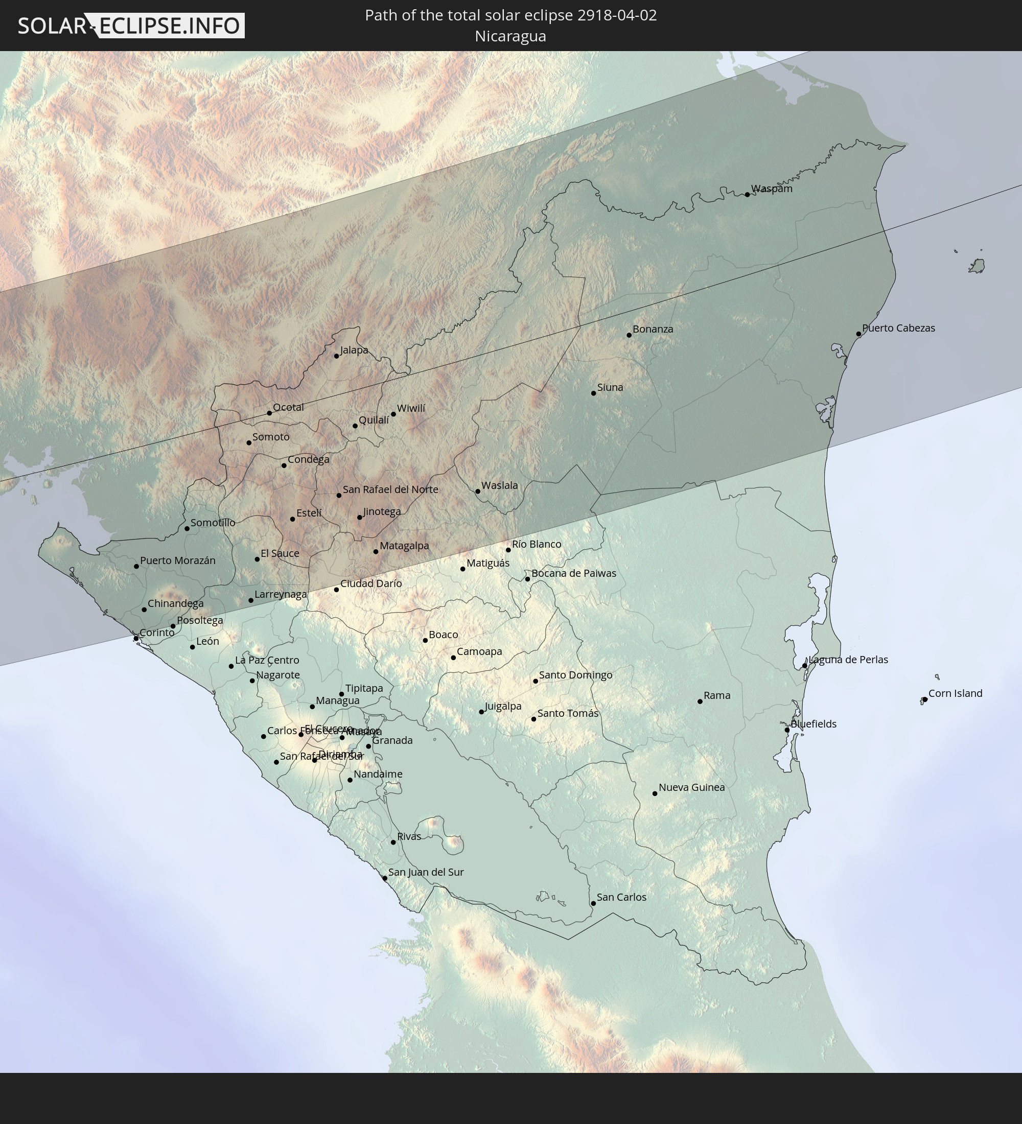 Nicaragua
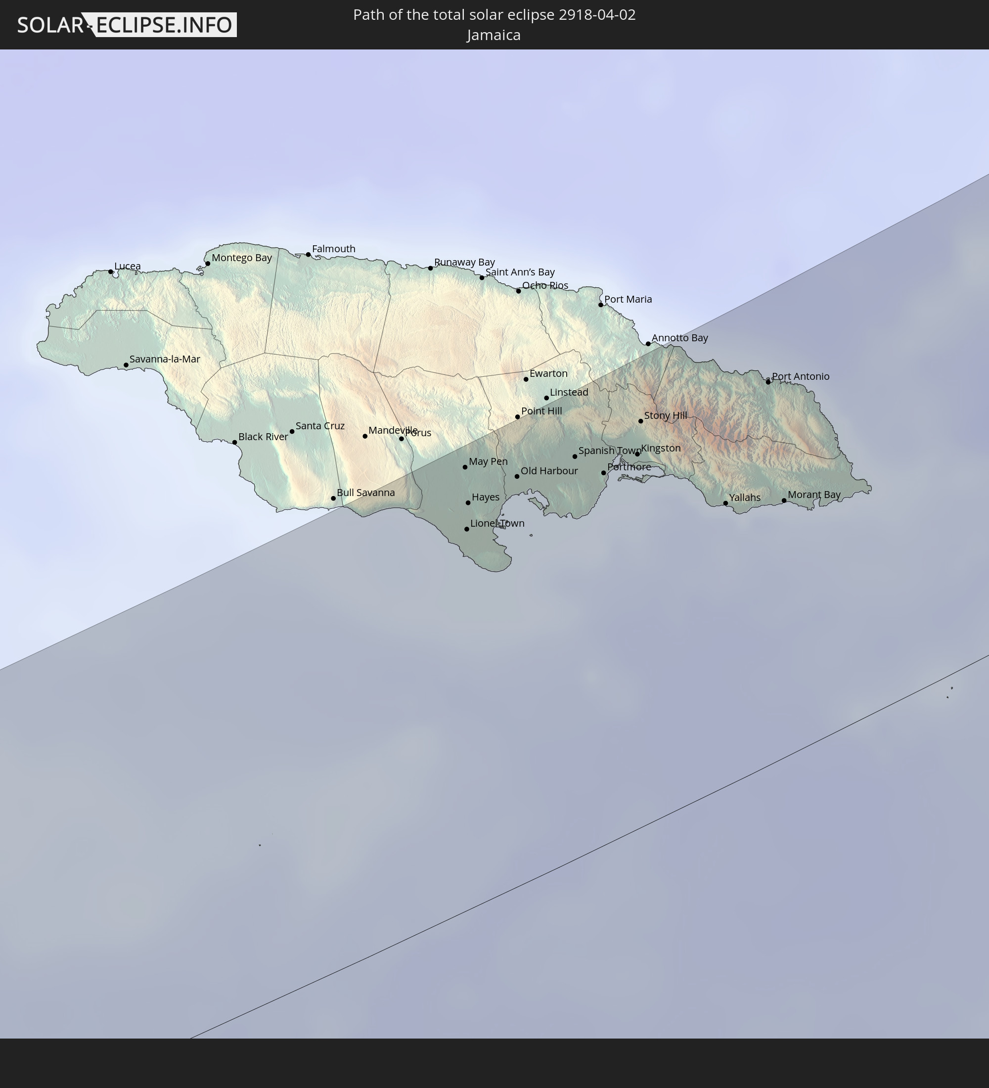 Jamaika
 Haiti
Haiti
 Turks- und Caicosinseln
 Dominikanische Republik
 Norwegen
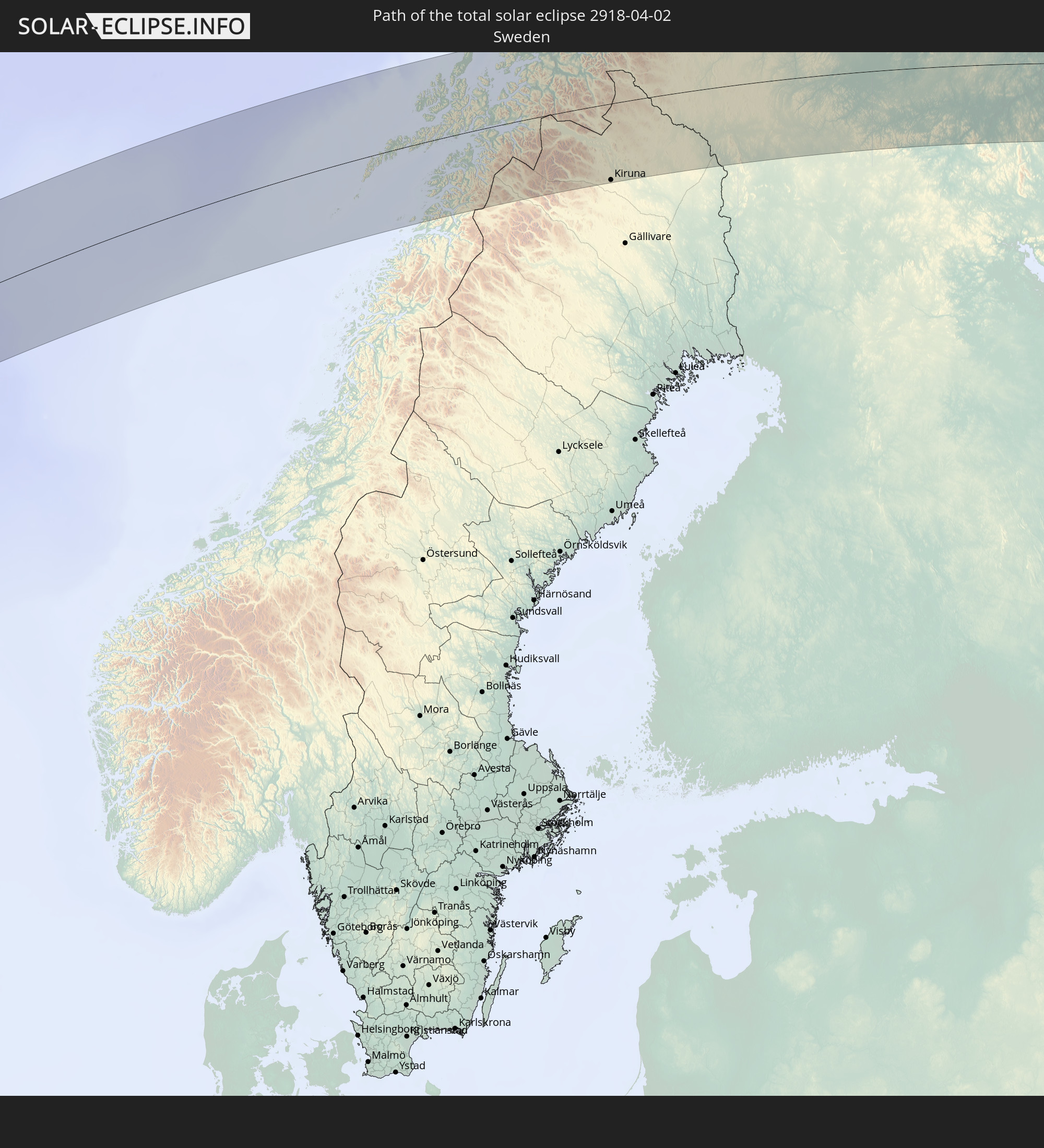 Schweden
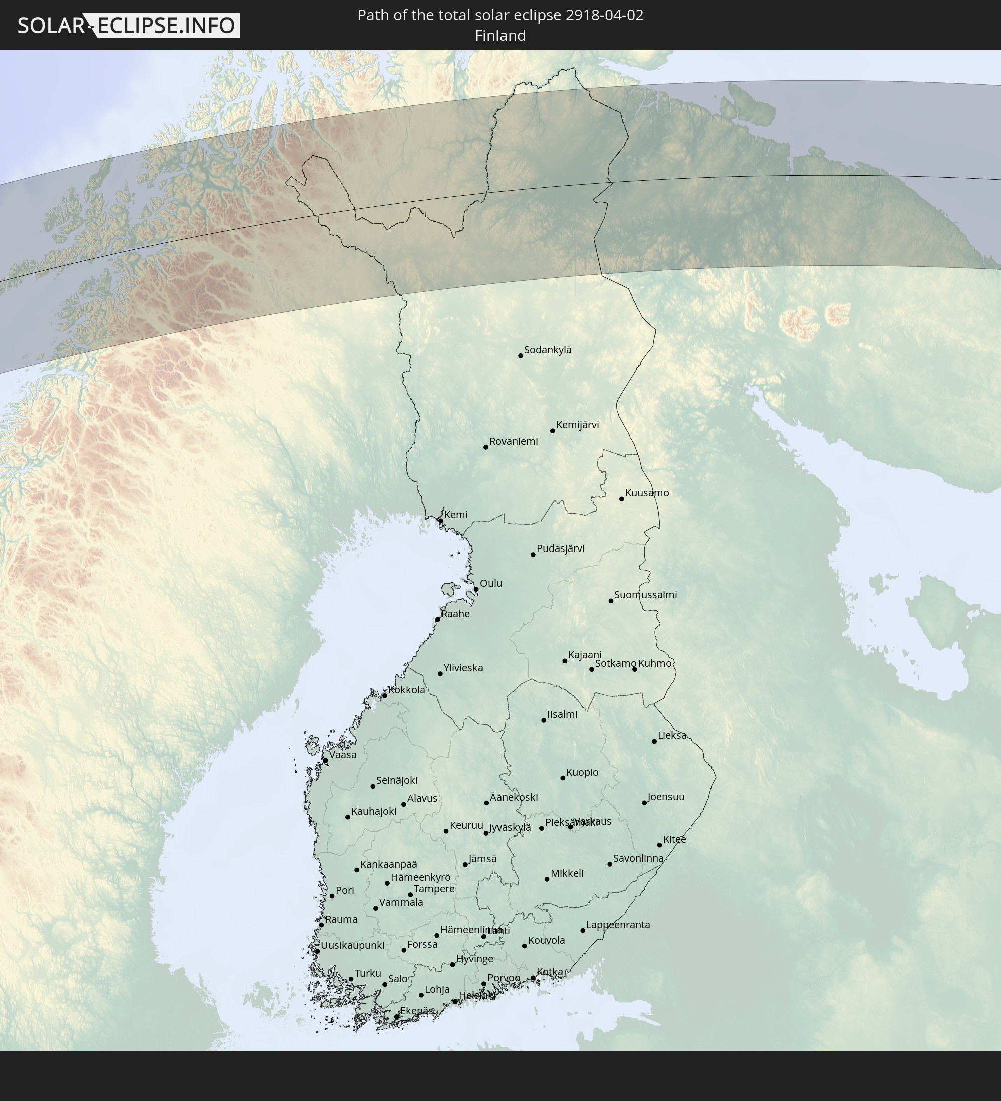 Finnland
In den folgenden Ländern ist die Sonnenfinsternis partiell zu sehen
 Russland
 Vereinigte Staaten
 United States Minor Outlying Islands
 Kanada
 Mexiko
 Chile
Chile
 Grönland
 Guatemala
 Ecuador
 El Salvador
 Honduras
 Belize
 Nicaragua
 Costa Rica
 Kuba
Kuba
 Panama
 Kolumbien
 Kaimaninseln
 Peru
Peru
 Bahamas
 Jamaika
 Haiti
Haiti
 Brasilien
 Venezuela
 Turks- und Caicosinseln
 Dominikanische Republik
 Aruba
Aruba
 Bolivien
 Puerto Rico
 Amerikanische Jungferninseln
 Bermuda
 Britische Jungferninseln
 Anguilla
 Saint-Martin
 Saint-Barthélemy
 St. Kitts und Nevis
 Antigua und Barbuda
 Montserrat
 Trinidad und Tobago
 Guadeloupe
 Grenada
 Dominica
 St. Vincent und die Grenadinen
 Guyana
 Martinique
 St. Lucia
 Barbados
 Suriname
 Saint-Pierre und Miquelon
 Französisch-Guayana
 Portugal
 Kap Verde
 Island
 Spanien
 Mauretanien
 Marokko
 Irland
 Spitzbergen
 Algerien
 Vereinigtes Königreich
 Färöer
 Gibraltar
 Frankreich
 Isle of Man
 Guernsey
 Jersey
 Andorra
 Belgien
 Niederlande
 Norwegen
 Luxemburg
 Deutschland
 Schweiz
 Italien
 Monaco
 Tunesien
 Dänemark
 Liechtenstein
 Österreich
 Schweden
 Tschechien
 San Marino
 Vatikanstadt
 Slowenien
 Kroatien
 Polen
Polen
 Malta
Malta
 Bosnien und Herzegowina
 Ungarn
 Slowakei
 Montenegro
 Serbien
 Albanien
 Åland Islands
 Griechenland
 Rumänien
 Mazedonien
 Finnland
 Litauen
 Lettland
 Estland
 Ukraine
 Bulgarien
 Weißrussland
 Türkei
 Moldawien
 Republik Zypern
 Syrien
 Georgien
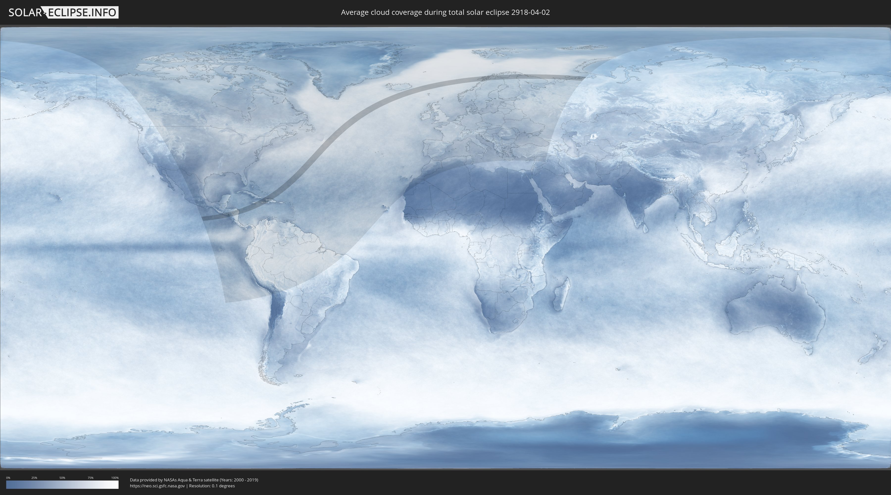
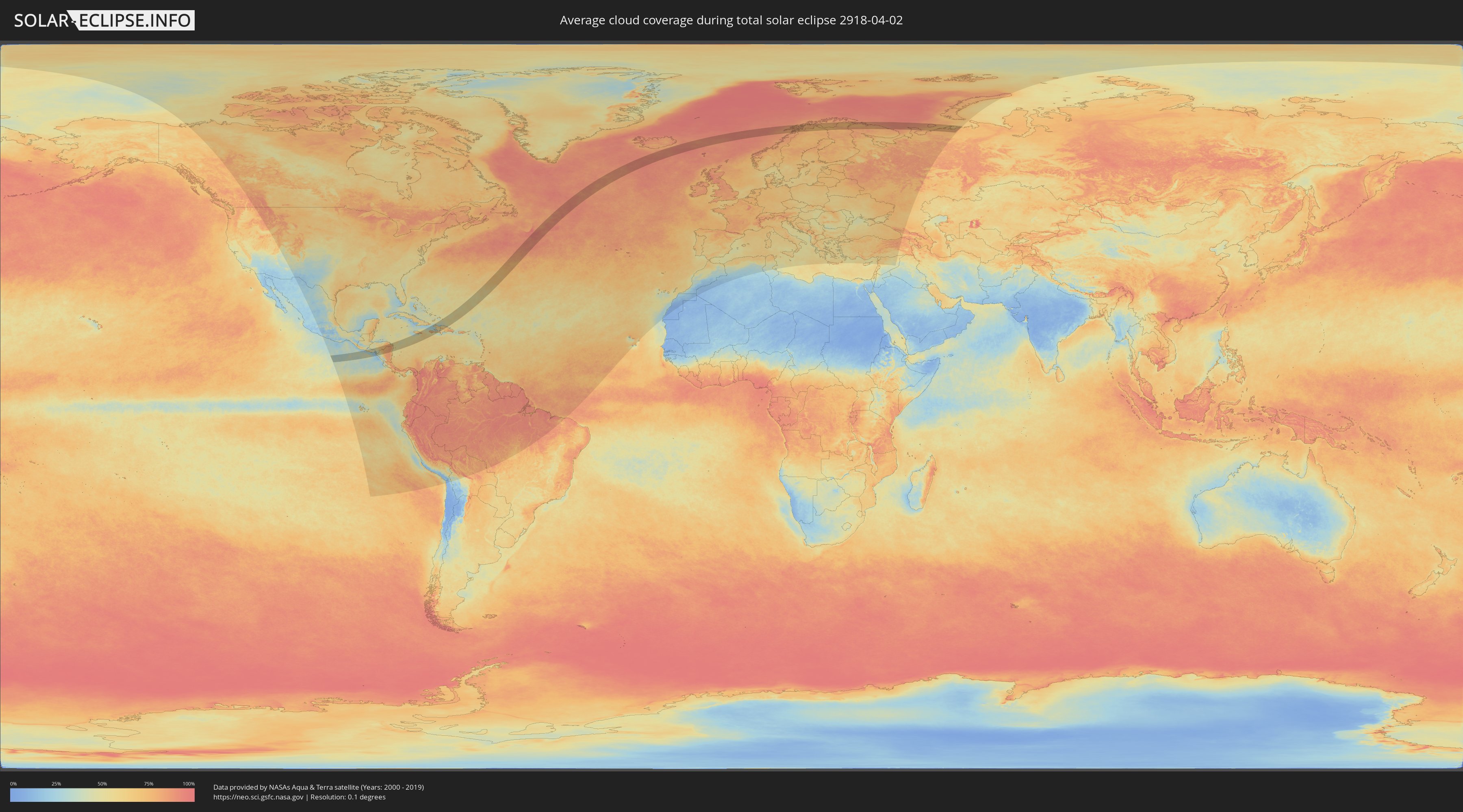
Wie wird das Wetter während der totalen Sonnenfinsternis am 02.04.2918?
Wo ist der beste Ort, um die totale Sonnenfinsternis vom 02.04.2918 zu beobachten?
Die folgenden Karten zeigen die durchschnittliche Bewölkung für den Tag, an dem die totale Sonnenfinsternis
stattfindet. Mit Hilfe der Karten lässt sich der Ort entlang des Finsternispfades eingrenzen,
der die besten Aussichen auf einen klaren wolkenfreien Himmel bietet.
Trotzdem muss man immer lokale Gegenenheiten beachten und sollte sich genau über das Wetter an seinem
gewählten Beobachtungsort informieren.
Die Daten stammen von den beiden NASA-Satelliten
AQUA und TERRA
und wurden über einen Zeitraum von 19 Jahren (2000 - 2019) gemittelt.
Detaillierte Länderkarten
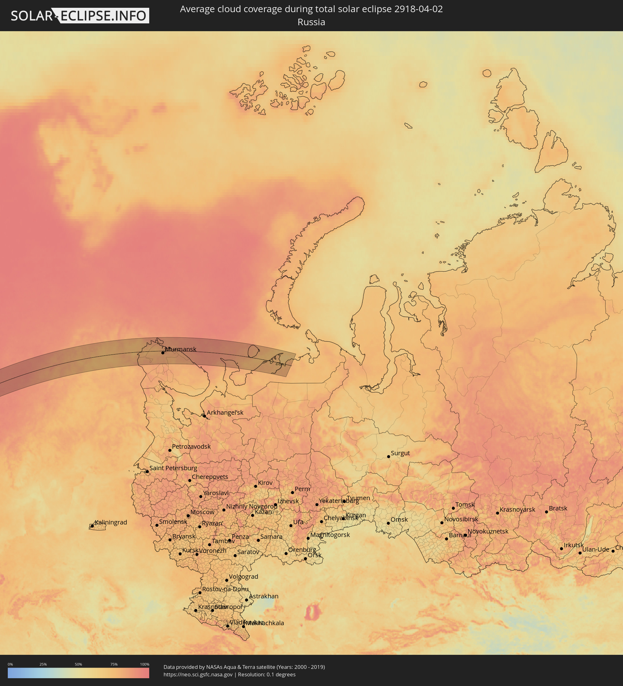 Russland
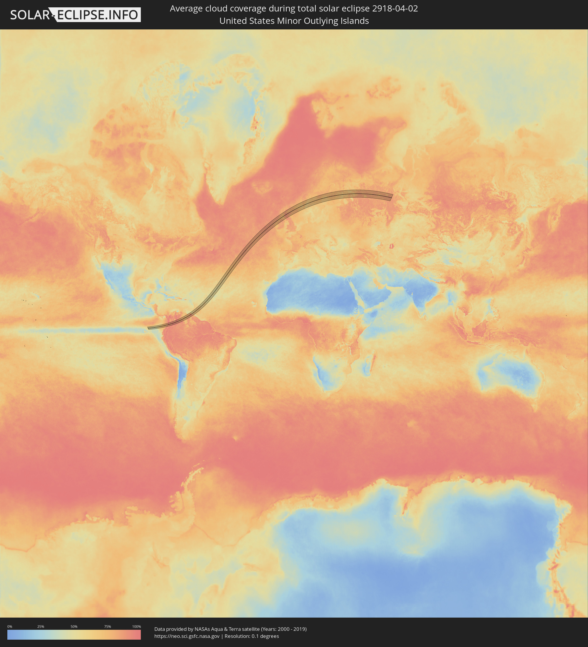 United States Minor Outlying Islands
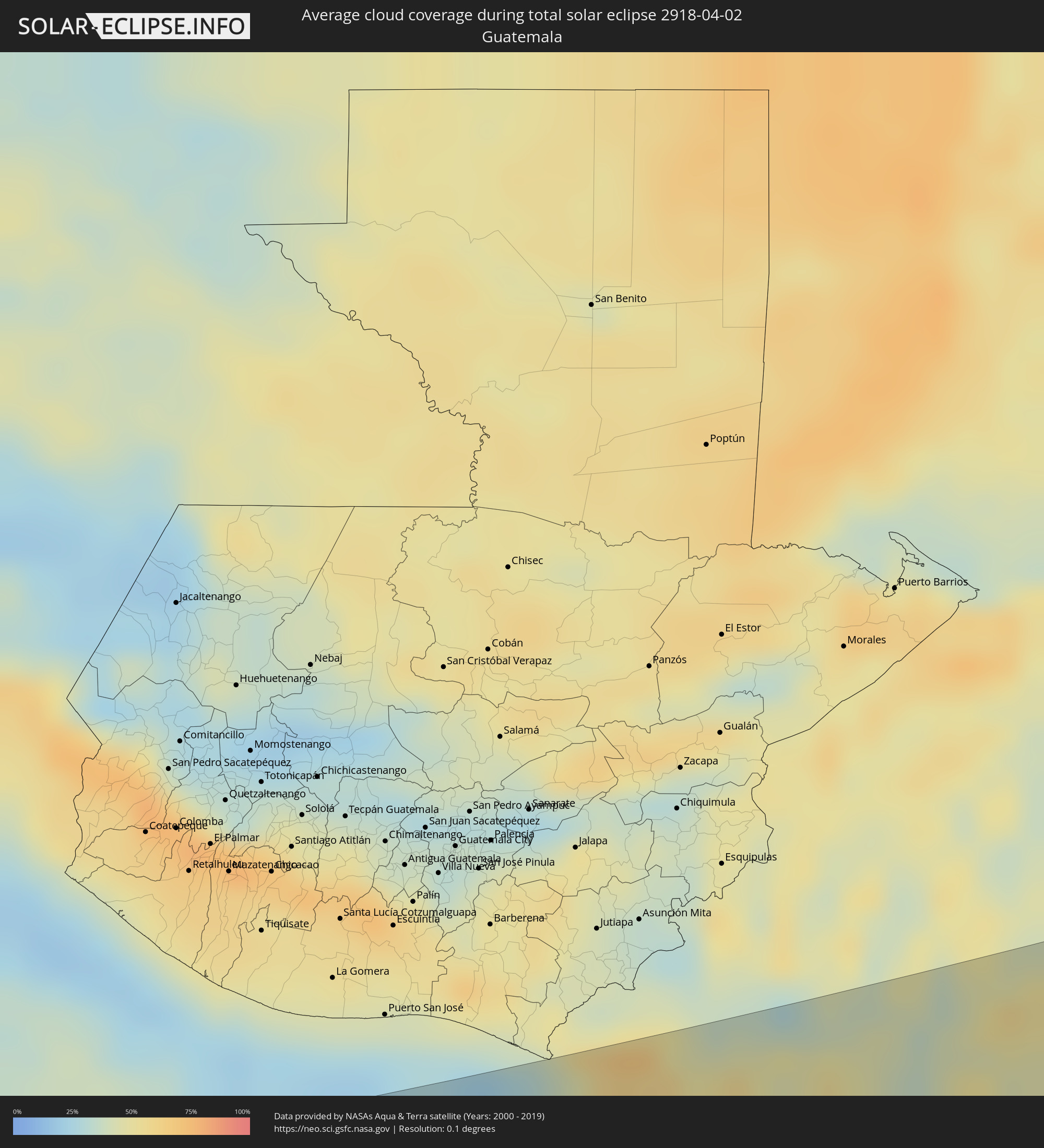 Guatemala
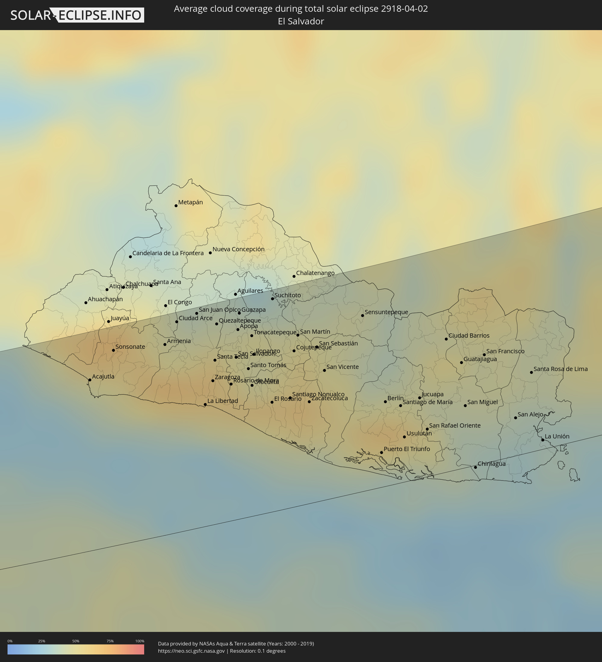 El Salvador
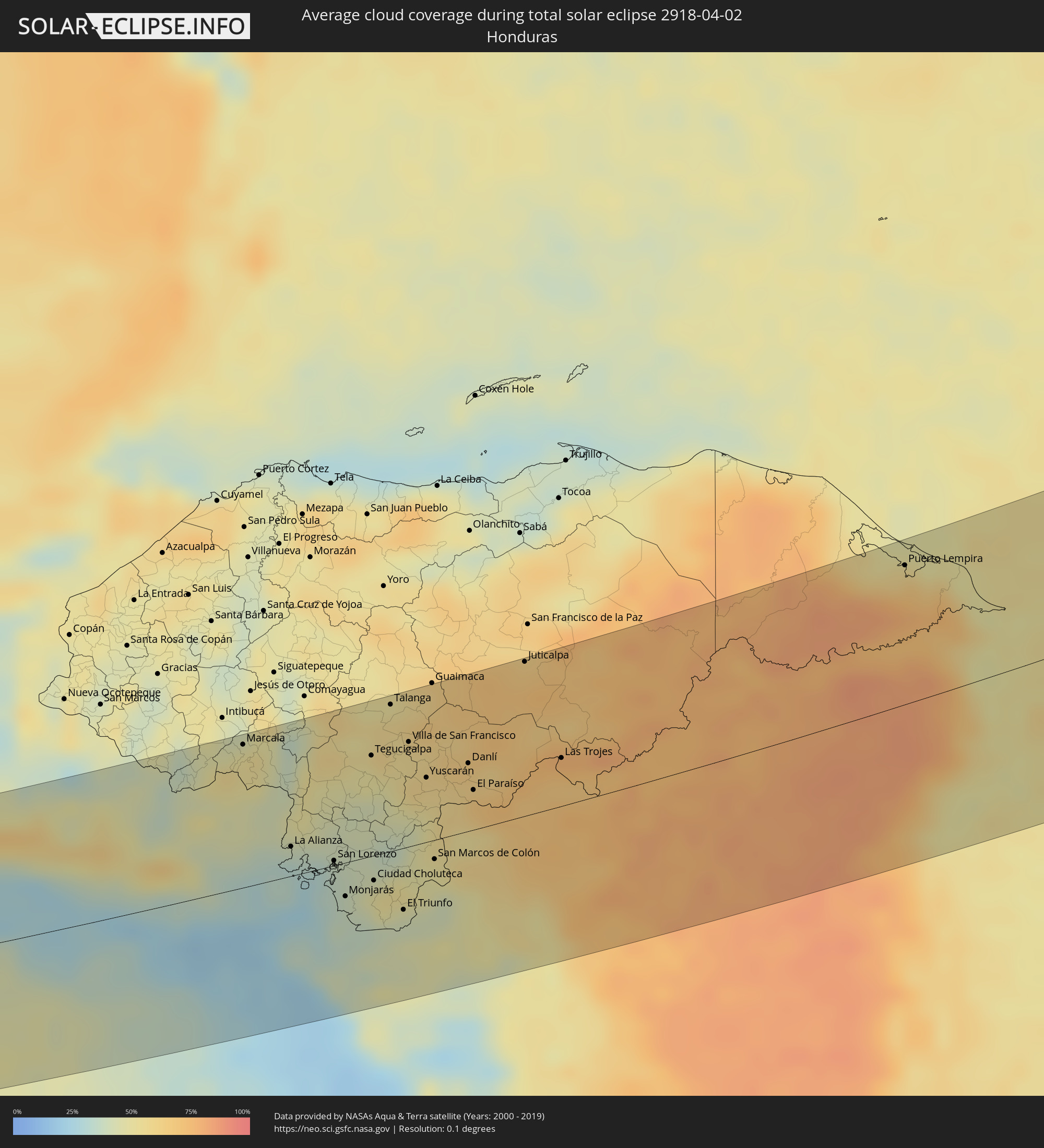 Honduras
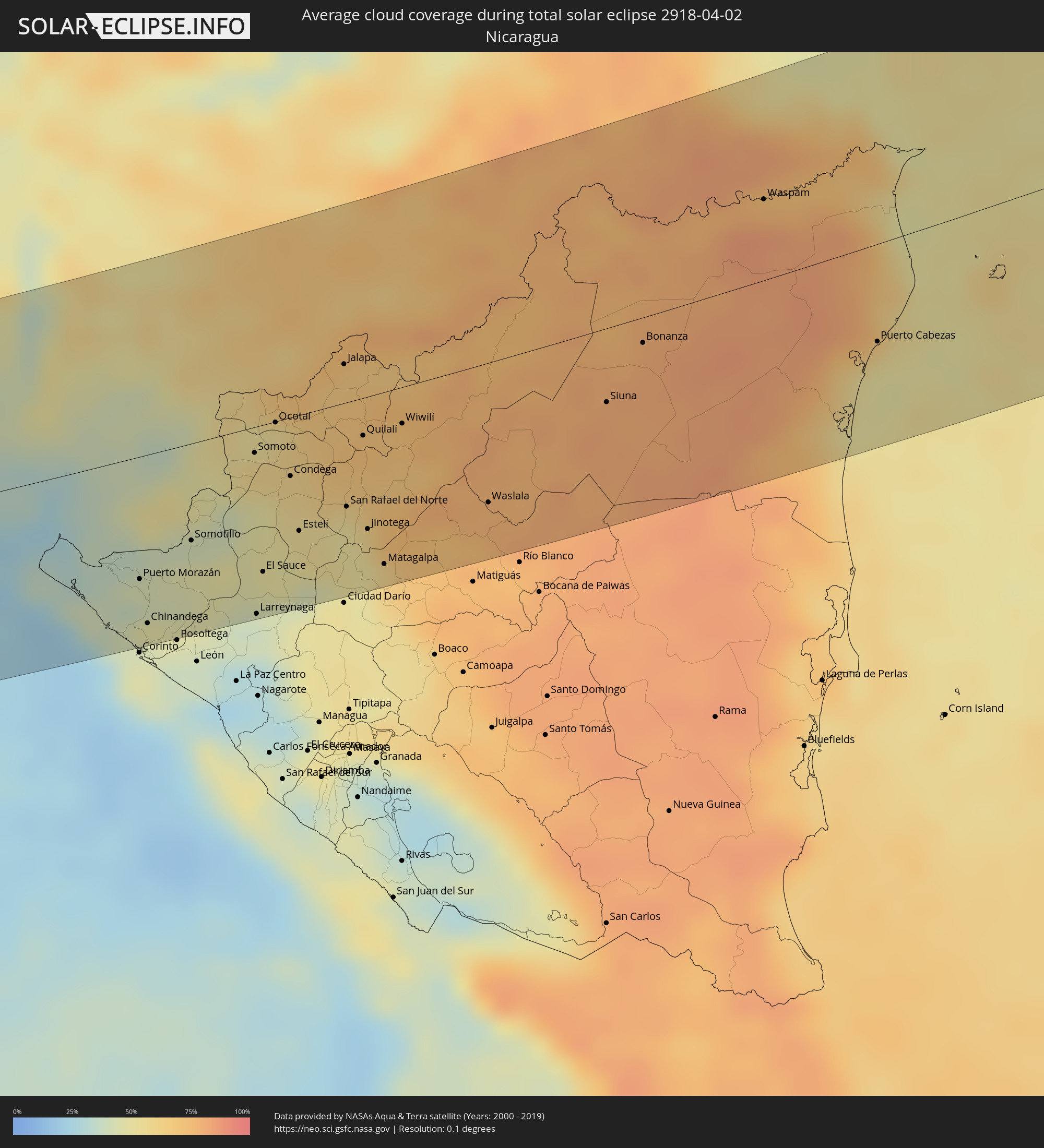 Nicaragua
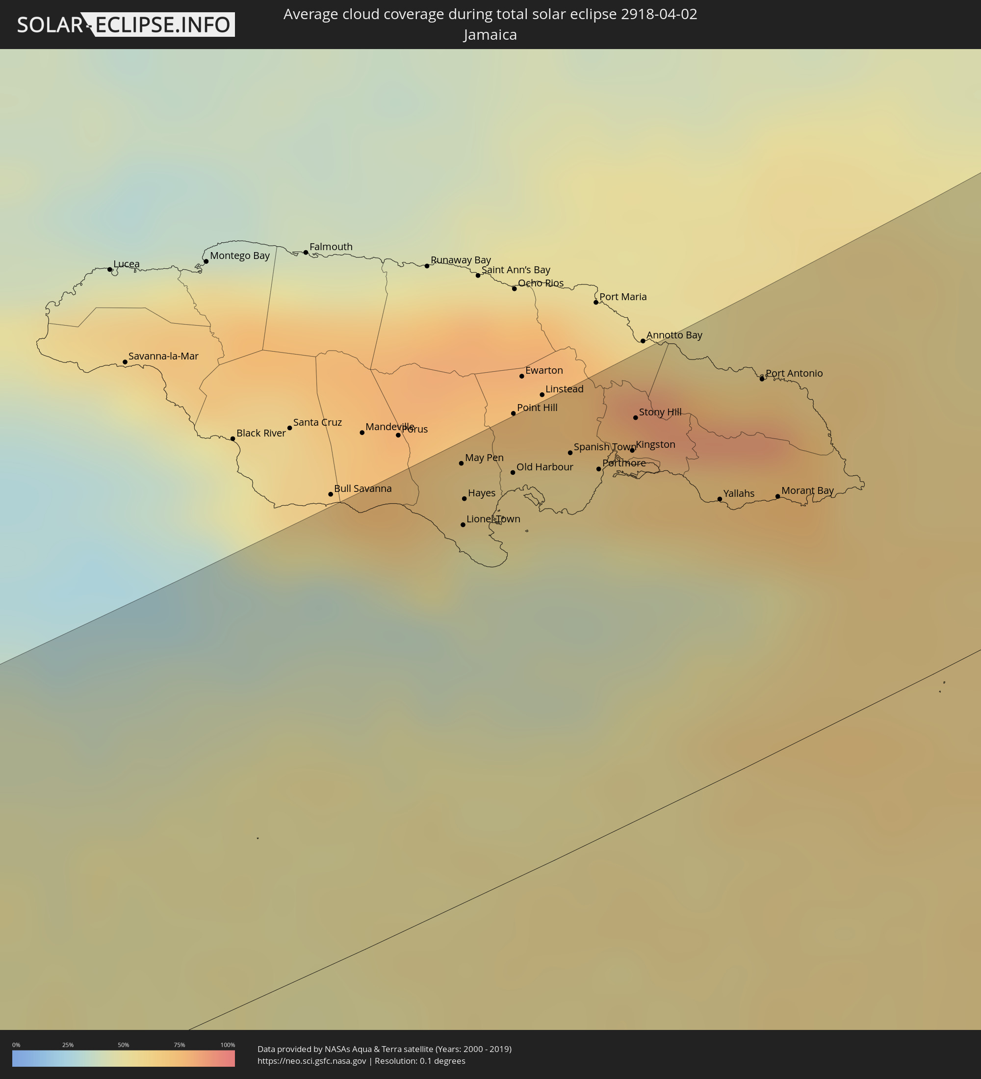 Jamaika
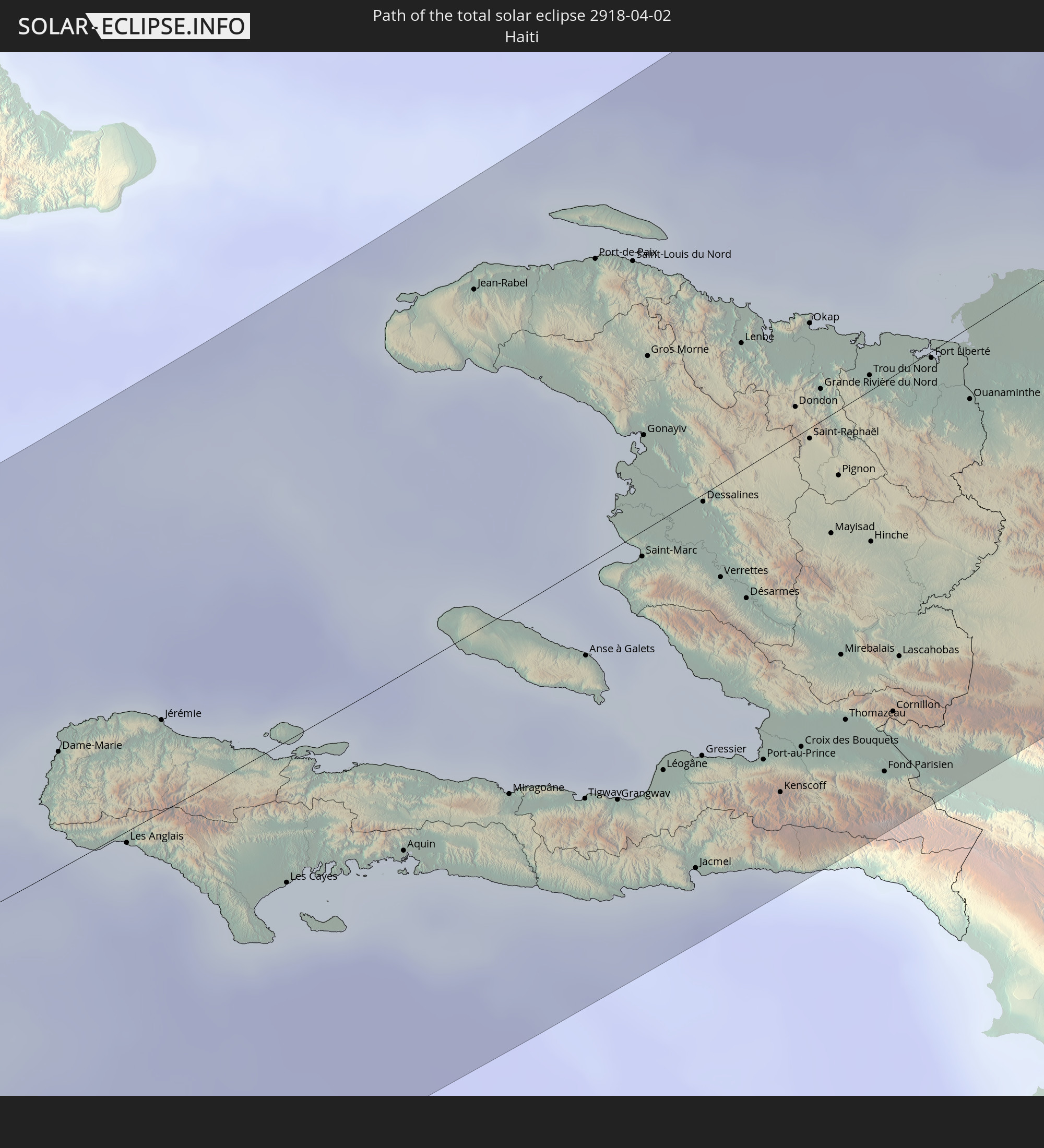
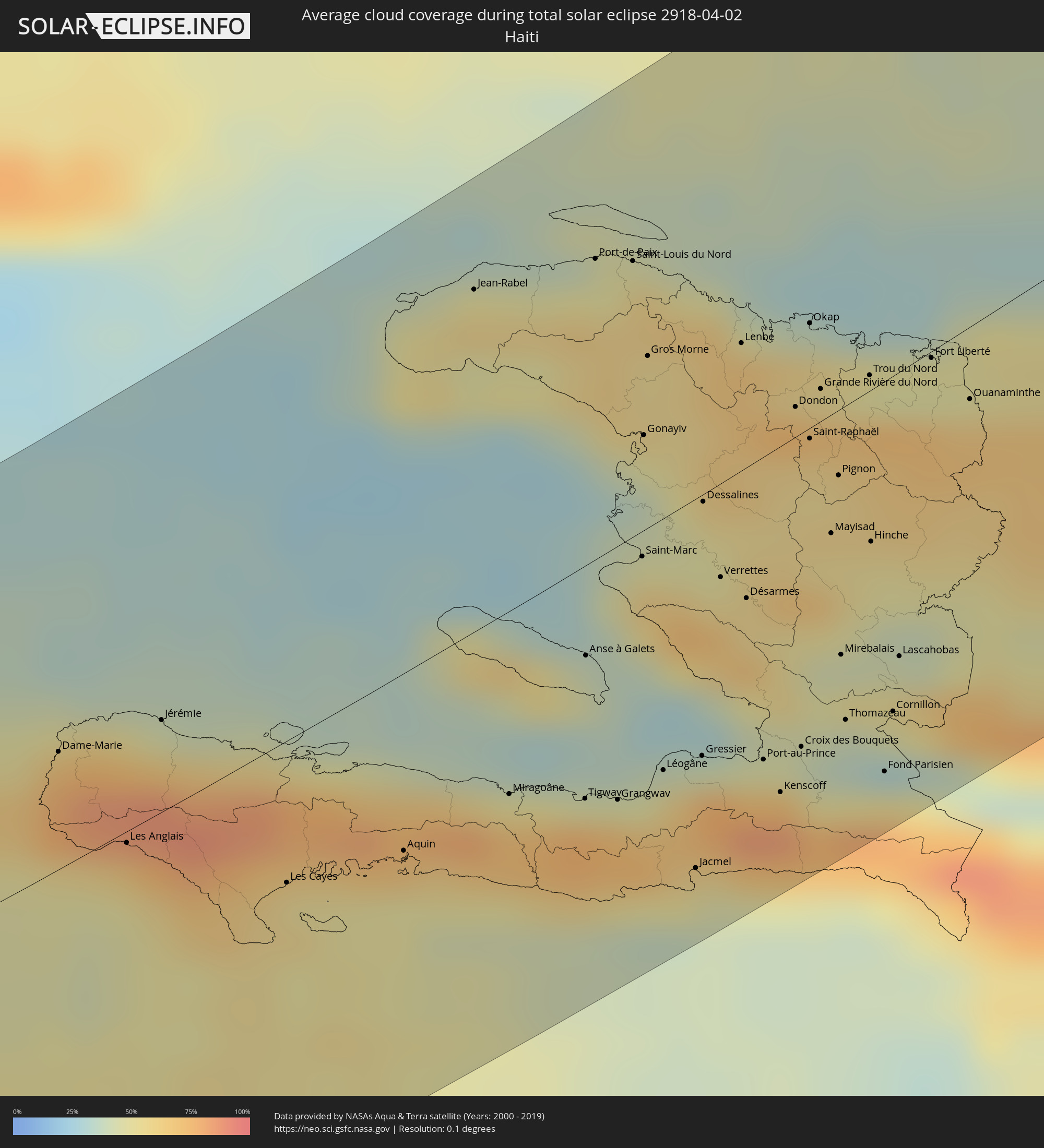 Haiti
Haiti
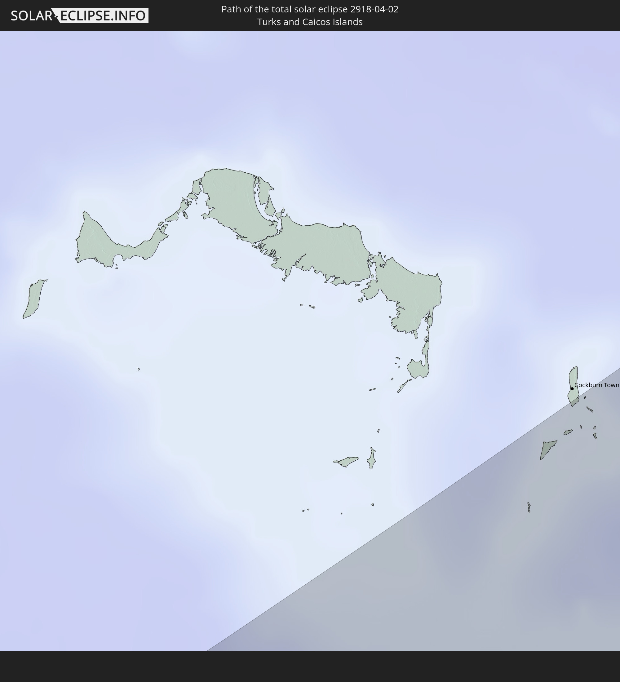
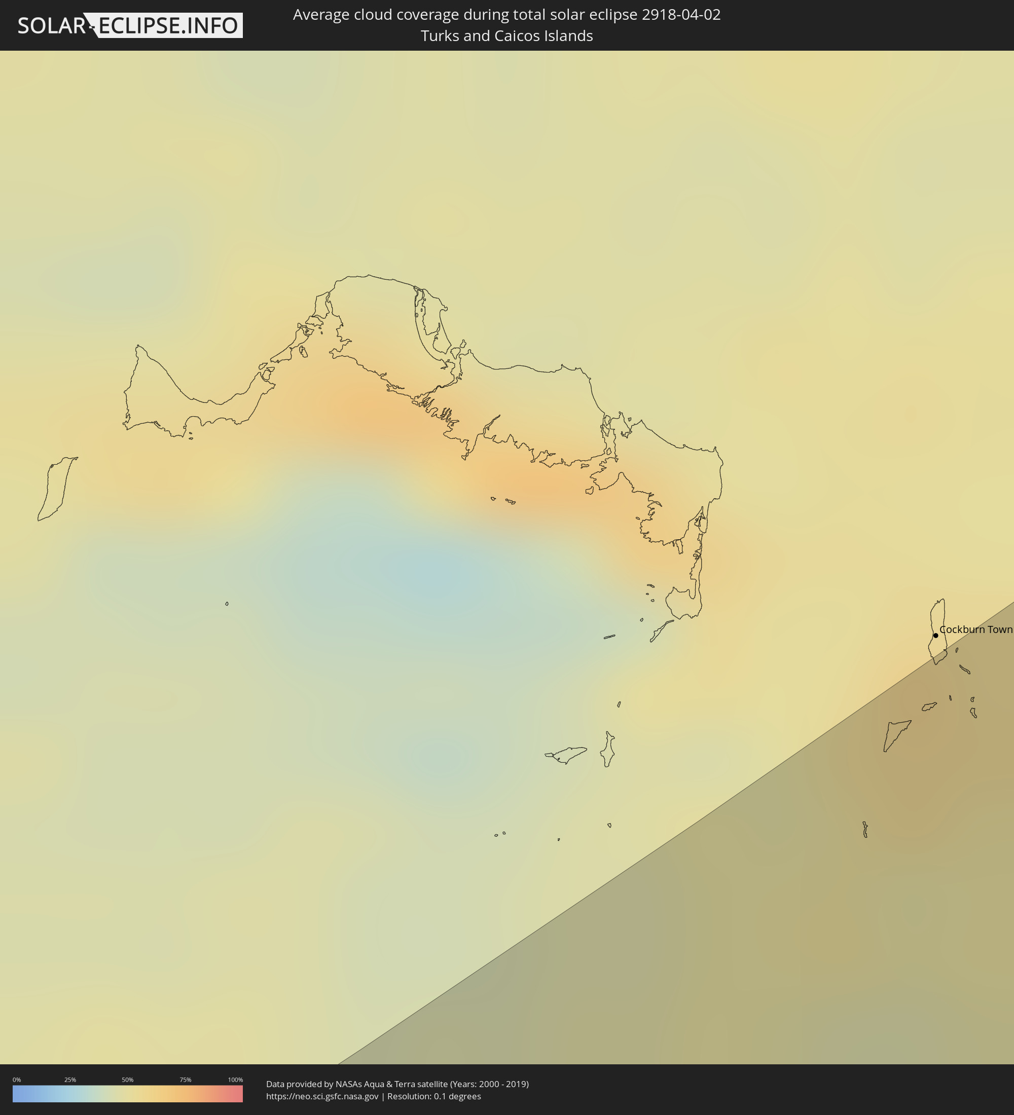 Turks- und Caicosinseln
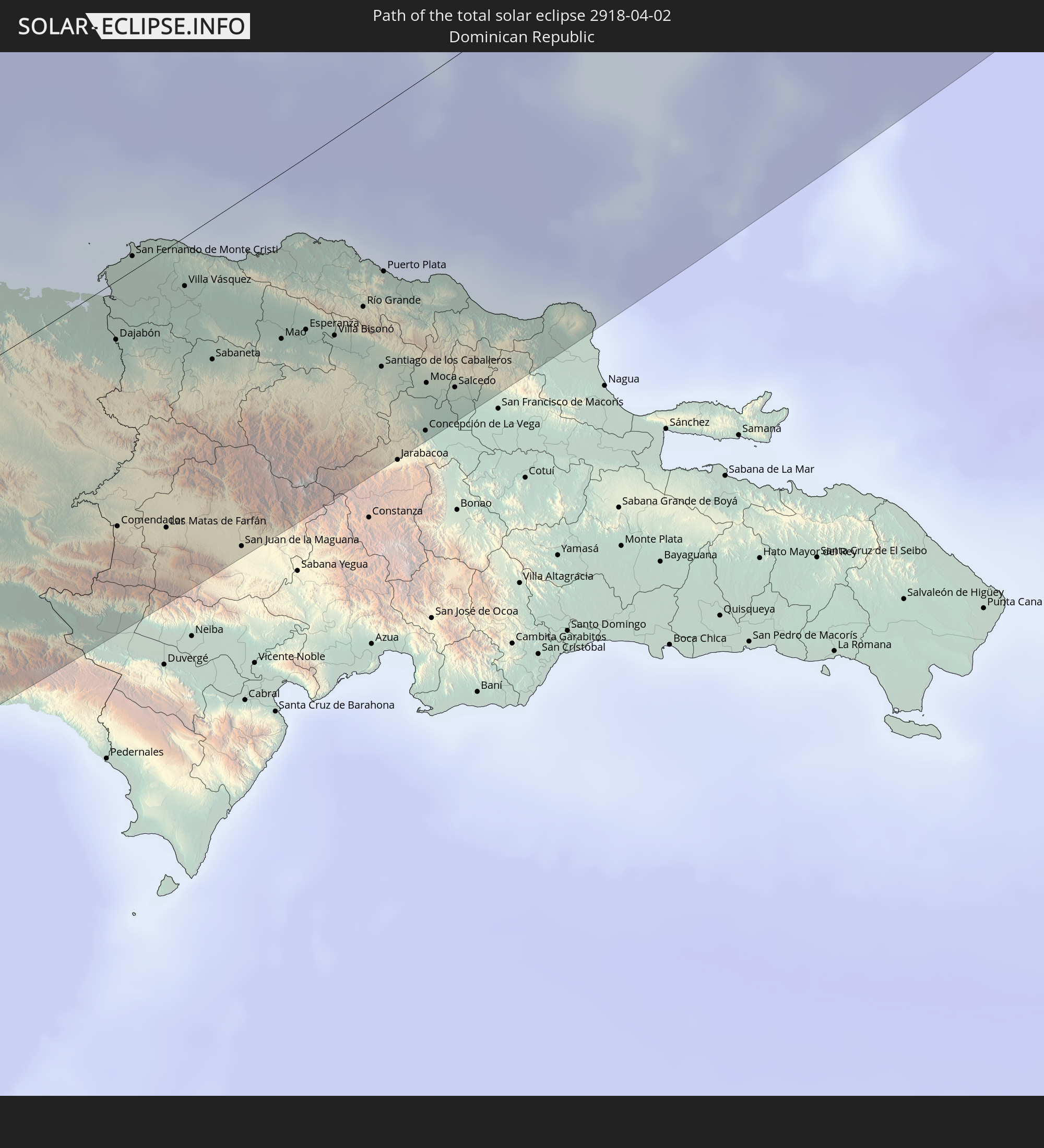
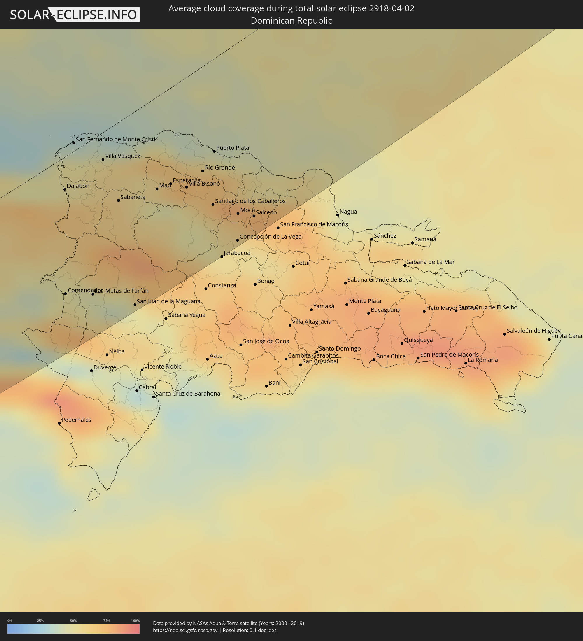 Dominikanische Republik
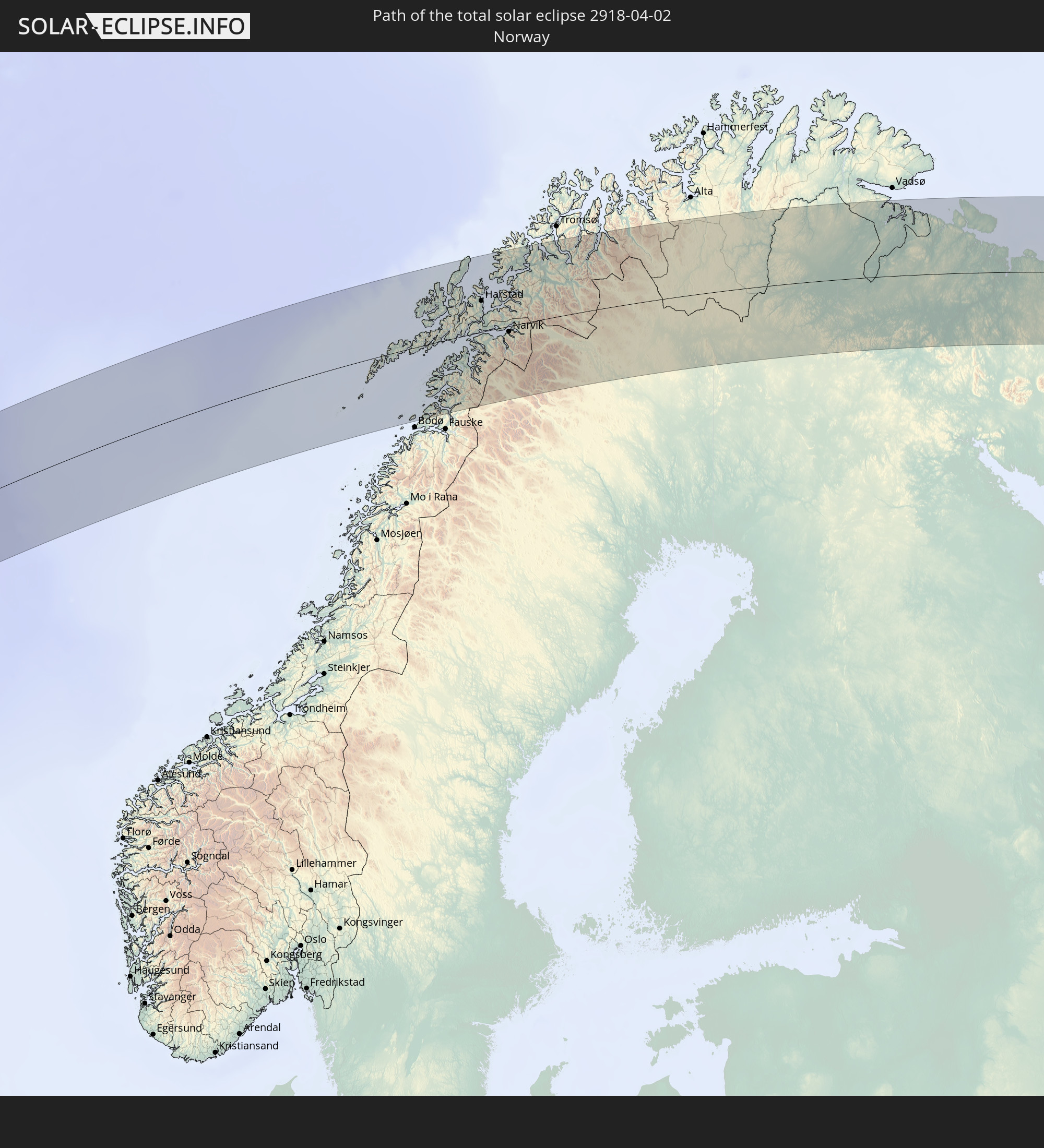
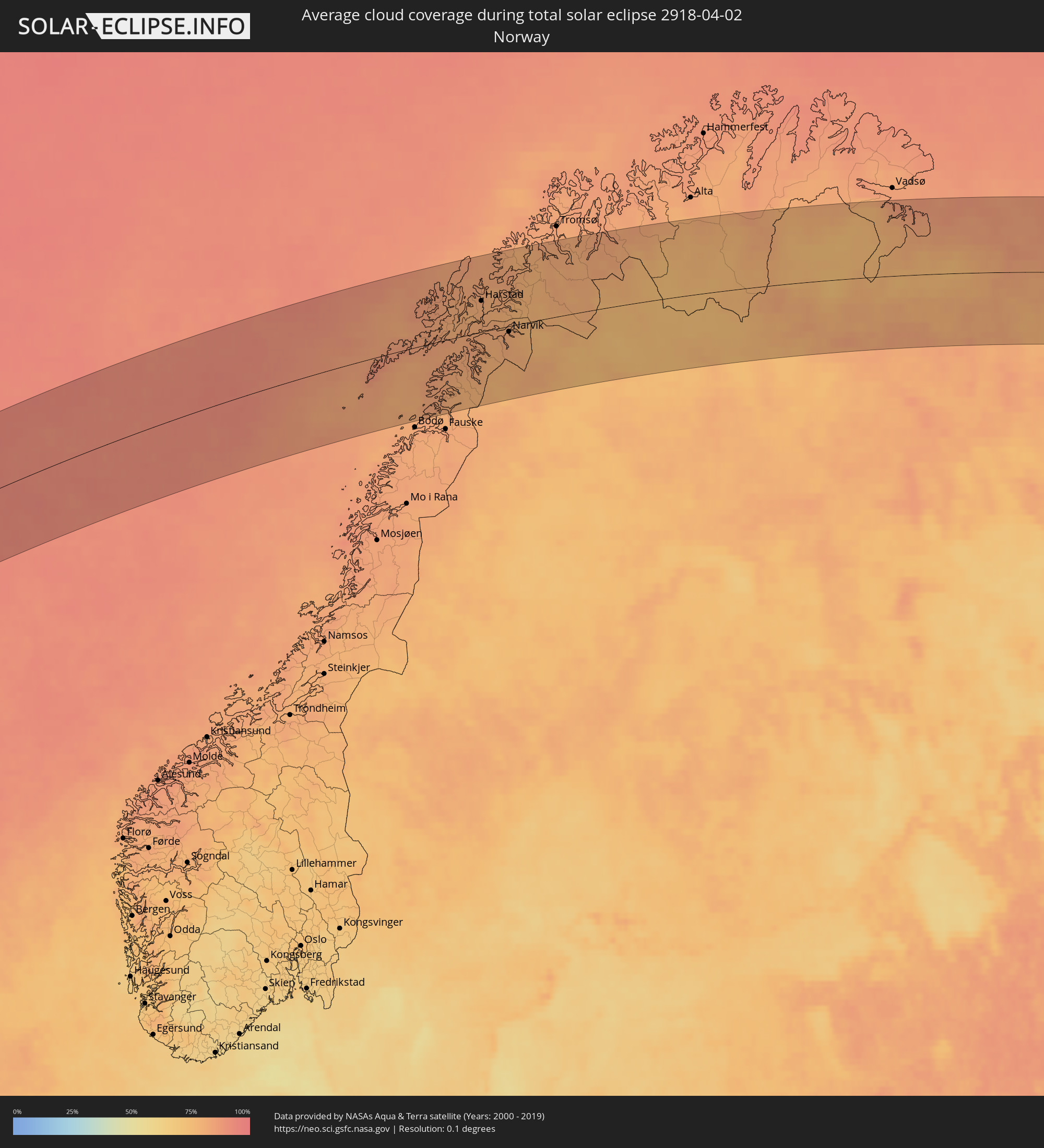 Norwegen
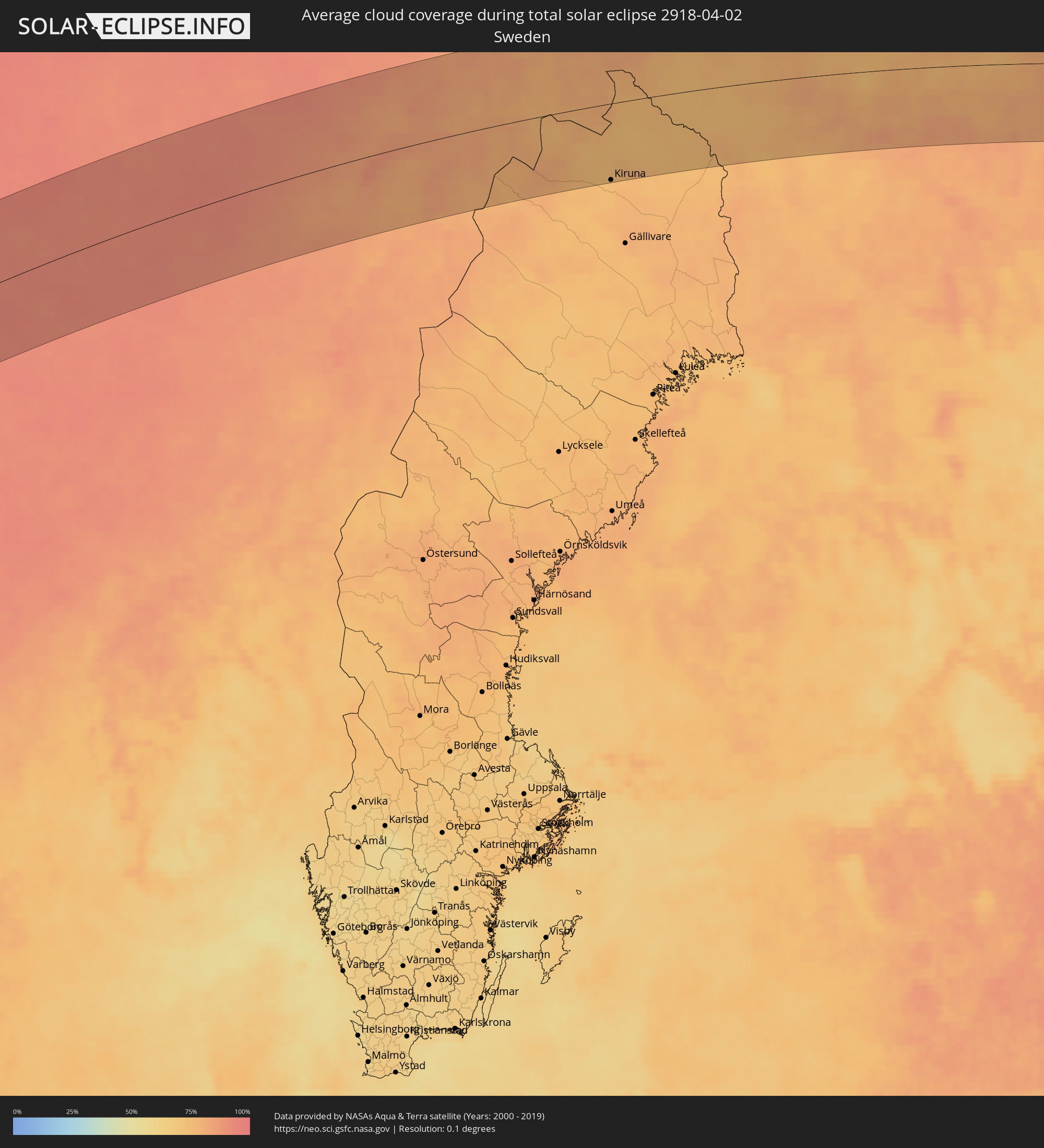 Schweden
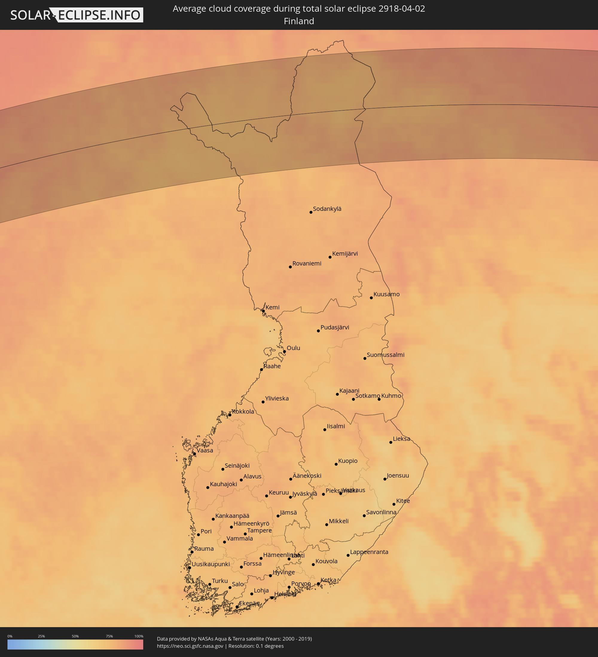 Finnland
Orte im Finsternispfad
Die nachfolgene Tabelle zeigt Städte und Orte mit mehr als 5.000 Einwohnern, die sich im Finsternispfad befinden. Städte mit mehr als 100.000 Einwohnern sind dick gekennzeichnet. Mit einem Klick auf den Ort öffnet sich eine Detailkarte die die Lage des jeweiligen Ortes zusammen mit dem Verlauf der zentralen Finsternis präsentiert.
| Ort | Typ | Dauer der Verfinsterung | Ortszeit bei maximaler Verfinsterung | Entfernung zur Zentrallinie | Ø Bewölkung |
|
Acajutla, Sonsonate
|
total | - | 06:35:22 UTC-06:00 | 79 km | 40% |
|
Sonsonate, Sonsonate
|
total | - | 06:35:33 UTC-06:00 | 91 km | 52% |
|
Armenia, Sonsonate
|
total | - | 06:35:37 UTC-06:00 | 88 km | 65% |
|
La Libertad, La Libertad
|
total | - | 06:35:19 UTC-06:00 | 56 km | 44% |
|
Quezaltepeque, La Libertad
|
total | - | 06:35:46 UTC-06:00 | 93 km | 55% |
|
San Salvador, San Salvador
|
total | - | 06:35:36 UTC-06:00 | 75 km | 54% |
|
Cojutepeque, Cuscatlán
|
total | - | 06:35:41 UTC-06:00 | 72 km | 56% |
|
Zacatecoluca, La Paz
|
total | - | 06:35:24 UTC-06:00 | 47 km | 54% |
|
San Vicente, San Vicente
|
total | - | 06:35:35 UTC-06:00 | 60 km | 56% |
|
Sensuntepeque, Cabañas
|
total | - | 06:35:56 UTC-06:00 | 81 km | 41% |
|
Jiquilisco, Usulután
|
total | - | 06:35:12 UTC-06:00 | 20 km | 36% |
|
Berlín, Usulután
|
total | - | 06:35:27 UTC-06:00 | 39 km | 62% |
|
Usulután, Usulután
|
total | - | 06:35:16 UTC-06:00 | 21 km | 50% |
|
Jucuapa, Usulután
|
total | - | 06:35:30 UTC-06:00 | 37 km | 55% |
|
Chinameca, San Miguel
|
total | - | 06:35:29 UTC-06:00 | 34 km | 55% |
|
Ciudad Barrios, San Miguel
|
total | - | 06:35:51 UTC-06:00 | 61 km | 50% |
|
San Miguel, San Miguel
|
total | - | 06:35:30 UTC-06:00 | 28 km | 38% |
|
San Francisco, Morazán
|
total | - | 06:35:48 UTC-06:00 | 50 km | 45% |
|
Marcala, La Paz
|
total | - | 06:36:25 UTC-06:00 | 97 km | 51% |
|
Santa Rosa de Lima, La Unión
|
total | - | 06:35:44 UTC-06:00 | 36 km | 38% |
|
La Unión, La Unión
|
total | - | 06:35:22 UTC-06:00 | 4 km | 32% |
|
La Alianza, Valle
|
total | - | 06:35:37 UTC-06:00 | 20 km | 32% |
|
Villa de San Antonio, Comayagua
|
total | - | 06:36:44 UTC-06:00 | 104 km | 42% |
|
Nacaome, Valle
|
total | - | 06:35:42 UTC-06:00 | 16 km | 32% |
|
San Lorenzo, Valle
|
total | - | 06:35:33 UTC-06:00 | 3 km | 36% |
|
Monjarás, Choluteca
|
total | - | 06:35:16 UTC-06:00 | 23 km | 35% |
|
Tegucigalpa, Francisco Morazán
|
total | - | 06:36:30 UTC-06:00 | 68 km | 50% |
|
Ciudad Choluteca, Choluteca
|
total | - | 06:35:26 UTC-06:00 | 17 km | 46% |
|
Puerto Morazán, Chinandega
|
total | - | 06:34:50 UTC-06:00 | 66 km | 42% |
|
Chinandega, Chinandega
|
total | - | 06:34:33 UTC-06:00 | 91 km | 42% |
|
Talanga, Francisco Morazán
|
total | - | 06:36:58 UTC-06:00 | 99 km | 57% |
|
Chichigalpa, Chinandega
|
total | - | 06:34:30 UTC-06:00 | 99 km | 44% |
|
El Triunfo, Choluteca
|
total | - | 06:35:14 UTC-06:00 | 42 km | 40% |
|
Villa de San Francisco, Francisco Morazán
|
total | - | 06:36:40 UTC-06:00 | 71 km | 55% |
|
Somotillo, Chinandega
|
total | - | 06:35:09 UTC-06:00 | 52 km | 46% |
|
Yuscarán, El Paraíso
|
total | - | 06:36:23 UTC-06:00 | 43 km | 54% |
|
San Marcos de Colón, Choluteca
|
total | - | 06:35:42 UTC-06:00 | 13 km | 48% |
|
Campamento, Olancho
|
total | - | 06:37:16 UTC-06:00 | 103 km | 65% |
|
Danlí, El Paraíso
|
total | - | 06:36:34 UTC-06:00 | 46 km | 61% |
|
Somoto, Madriz
|
total | - | 06:35:49 UTC-06:00 | 14 km | 58% |
|
Larreynaga, León
|
total | - | 06:34:44 UTC-06:00 | 101 km | 38% |
|
El Paraíso, El Paraíso
|
total | - | 06:36:21 UTC-06:00 | 27 km | 60% |
|
El Sauce, León
|
total | - | 06:35:01 UTC-06:00 | 79 km | 48% |
|
Ocotal, Nueva Segovia
|
total | - | 06:36:03 UTC-06:00 | 1 km | 55% |
|
Condega, Estelí
|
total | - | 06:35:42 UTC-06:00 | 31 km | 59% |
|
Estelí, Estelí
|
total | - | 06:35:20 UTC-06:00 | 62 km | 51% |
|
Juticalpa, Olancho
|
total | - | 06:37:32 UTC-06:00 | 103 km | 67% |
|
Jalapa, Nueva Segovia
|
total | - | 06:36:32 UTC-06:00 | 21 km | 67% |
|
Quilalí, Nueva Segovia
|
total | - | 06:36:04 UTC-06:00 | 20 km | 72% |
|
Jinotega, Jinotega
|
total | - | 06:35:26 UTC-06:00 | 71 km | 55% |
|
Las Trojes, El Paraíso
|
total | - | 06:36:46 UTC-06:00 | 32 km | 72% |
|
Matagalpa, Matagalpa
|
total | - | 06:35:13 UTC-06:00 | 92 km | 62% |
|
Wiwilí, Nueva Segovia
|
total | - | 06:36:12 UTC-06:00 | 20 km | 71% |
|
Waslala, Atlántico Norte (RAAN)
|
total | - | 06:35:46 UTC-06:00 | 75 km | 77% |
|
Siuna, Atlántico Norte (RAAN)
|
total | - | 06:36:37 UTC-06:00 | 39 km | 81% |
|
Bonanza, Atlántico Norte (RAAN)
|
total | - | 06:37:05 UTC-06:00 | 13 km | 80% |
|
Waspam, Atlántico Norte (RAAN)
|
total | - | 06:38:17 UTC-06:00 | 43 km | 85% |
|
Puerto Lempira, Gracias a Dios
|
total | - | 06:39:06 UTC-06:00 | 92 km | 62% |
|
Puerto Cabezas, Atlántico Norte (RAAN)
|
total | - | 06:37:27 UTC-06:00 | 51 km | 51% |
|
May Pen, Clarendon
|
total | - | 07:46:05 UTC-05:00 | 111 km | 61% |
|
Lionel Town, Clarendon
|
total | - | 07:45:51 UTC-05:00 | 96 km | 42% |
|
Hayes, Clarendon
|
total | - | 07:45:57 UTC-05:00 | 102 km | 48% |
|
Old Harbour, Saint Catherine
|
total | - | 07:46:08 UTC-05:00 | 103 km | 50% |
|
Old Harbour Bay, Saint Catherine
|
total | - | 07:46:05 UTC-05:00 | 99 km | 50% |
|
Bog Walk, Saint Catherine
|
total | - | 07:46:27 UTC-05:00 | 114 km | 70% |
|
Spanish Town, Saint Catherine
|
total | - | 07:46:18 UTC-05:00 | 101 km | 57% |
|
Portmore, Saint Catherine
|
total | - | 07:46:16 UTC-05:00 | 93 km | 58% |
|
Half Way Tree, St. Andrew
|
total | - | 07:46:25 UTC-05:00 | 95 km | 63% |
|
Constant Spring, St. Andrew
|
total | - | 07:46:29 UTC-05:00 | 99 km | 75% |
|
Kingston, Kingston
|
total | - | 07:46:24 UTC-05:00 | 93 km | 63% |
|
Stony Hill, St. Andrew
|
total | - | 07:46:32 UTC-05:00 | 101 km | 75% |
|
New Kingston, St. Andrew
|
total | - | 07:46:25 UTC-05:00 | 94 km | 63% |
|
Yallahs, St. Thomas
|
total | - | 07:46:20 UTC-05:00 | 70 km | 55% |
|
Port Antonio, Portland
|
total | - | 07:46:53 UTC-05:00 | 95 km | 69% |
|
Morant Bay, St. Thomas
|
total | - | 07:46:25 UTC-05:00 | 64 km | 63% |
|
Jérémie, GrandʼAnse
|
total | - | 07:49:05 UTC-05:00 | 25 km | 46% |
|
Les Cayes, Sud
|
total | - | 07:48:34 UTC-05:00 | 39 km | 54% |
|
Miragoâne, Nippes
|
total | - | 07:49:25 UTC-05:00 | 49 km | 71% |
|
Tigwav, Ouest
|
total | - | 07:49:32 UTC-05:00 | 62 km | 75% |
|
Port-de-Paix, Nord-Ouest
|
total | - | 07:52:08 UTC-05:00 | 80 km | 50% |
|
Saint-Louis du Nord, Nord-Ouest
|
total | - | 07:52:12 UTC-05:00 | 73 km | 58% |
|
Saint-Marc, Artibonite
|
total | - | 07:50:48 UTC-05:00 | 7 km | 60% |
|
Gonayiv, Artibonite
|
total | - | 07:51:23 UTC-05:00 | 25 km | 39% |
|
Léogâne, Ouest
|
total | - | 07:49:50 UTC-05:00 | 67 km | 62% |
|
Jacmel, Sud-Est
|
total | - | 07:49:26 UTC-05:00 | 99 km | 46% |
|
Dessalines, Artibonite
|
total | - | 07:51:12 UTC-05:00 | 2 km | 52% |
|
Verrettes, Artibonite
|
total | - | 07:50:52 UTC-05:00 | 25 km | 55% |
|
Lenbe, Nord
|
total | - | 07:52:02 UTC-05:00 | 34 km | 65% |
|
Port-au-Prince, Ouest
|
total | - | 07:50:05 UTC-05:00 | 81 km | 70% |
|
Okap, Nord
|
total | - | 07:52:16 UTC-05:00 | 28 km | 38% |
|
Saint-Raphaël, Nord
|
total | - | 07:51:43 UTC-05:00 | 3 km | 56% |
|
Thomazeau, Ouest
|
total | - | 07:50:27 UTC-05:00 | 83 km | 41% |
|
Hinche, Centre
|
total | - | 07:51:21 UTC-05:00 | 40 km | 52% |
|
Fond Parisien, Ouest
|
total | - | 07:50:17 UTC-05:00 | 103 km | 54% |
|
Fort Liberté, Nord-Est
|
total | - | 07:52:22 UTC-05:00 | 2 km | 49% |
|
Dajabón, Dajabón
|
total | - | 08:52:15 UTC-04:00 | 20 km | 67% |
|
Comendador, Elías Piña
|
total | - | 08:51:06 UTC-04:00 | 83 km | 53% |
|
San Fernando de Monte Cristi, Monte Cristi
|
total | - | 08:52:49 UTC-04:00 | 5 km | 49% |
|
Las Matas de Farfán, San Juan
|
total | - | 08:51:14 UTC-04:00 | 94 km | 46% |
|
Las Matas de Santa Cruz, Monte Cristi
|
total | - | 08:52:37 UTC-04:00 | 20 km | 56% |
|
Villa Vásquez, Monte Cristi
|
total | - | 08:52:47 UTC-04:00 | 16 km | 59% |
|
Sabaneta, Santiago Rodríguez
|
total | - | 08:52:24 UTC-04:00 | 47 km | 61% |
|
San Juan de la Maguana, San Juan
|
total | - | 08:51:20 UTC-04:00 | 117 km | 50% |
|
Mao, Valverde
|
total | - | 08:52:43 UTC-04:00 | 55 km | 48% |
|
San José de Las Matas, Santiago
|
total | - | 08:52:28 UTC-04:00 | 83 km | 57% |
|
Villa Bisonó, Santiago
|
total | - | 08:52:54 UTC-04:00 | 66 km | 52% |
|
Imbert, Puerto Plata
|
total | - | 08:53:16 UTC-04:00 | 51 km | 57% |
|
Villa González, Santiago
|
total | - | 08:52:55 UTC-04:00 | 73 km | 51% |
|
Río Grande, Puerto Plata
|
total | - | 08:53:09 UTC-04:00 | 62 km | 70% |
|
Santiago de los Caballeros, Santiago
|
total | - | 08:52:50 UTC-04:00 | 86 km | 57% |
|
Puerto Plata, Puerto Plata
|
total | - | 08:53:26 UTC-04:00 | 55 km | 56% |
|
Concepción de La Vega, La Vega
|
total | - | 08:52:34 UTC-04:00 | 117 km | 56% |
|
Moca, Espaillat
|
total | - | 08:52:52 UTC-04:00 | 102 km | 60% |
|
Salsipuedes, Hermanas Mirabal
|
total | - | 08:53:00 UTC-04:00 | 109 km | 65% |
|
Río San Juan, María Trinidad Sánchez
|
total | - | 08:53:38 UTC-04:00 | 105 km | 68% |
|
Harstad, Troms
|
total | - | 16:05:08 UTC+01:00 | 40 km | 80% |
|
Narvik, Nordland
|
total | - | 16:05:46 UTC+01:00 | 7 km | 80% |
|
Kiruna, Norrbotten
|
total | - | 16:07:12 UTC+01:00 | 92 km | 74% |
|
Inari, Lapland
|
total | - | 17:07:43 UTC+02:00 | 12 km | 79% |
|
Nikel, Murmansk
|
total | - | 18:07:43 UTC+03:00 | 35 km | 80% |
|
Zapolyarnyy, Murmansk
|
total | - | 18:07:48 UTC+03:00 | 35 km | 76% |
|
Zaozërsk, Murmansk
|
total | - | 18:08:04 UTC+03:00 | 31 km | 80% |
|
Vidyayevo, Murmansk
|
total | - | 18:08:13 UTC+03:00 | 21 km | 81% |
|
Murmashi, Murmansk
|
total | - | 18:08:48 UTC+03:00 | 35 km | 81% |
|
Vidyayevo, Murmansk
|
total | - | 18:08:45 UTC+03:00 | 27 km | 81% |
|
Kola, Murmansk
|
total | - | 18:08:45 UTC+03:00 | 28 km | 81% |
|
Molochnyy, Murmansk
|
total | - | 18:08:47 UTC+03:00 | 31 km | 81% |
|
Murmansk, Murmansk
|
total | - | 18:08:39 UTC+03:00 | 17 km | 81% |
|
Roslyakovo, Murmansk
|
total | - | 18:08:35 UTC+03:00 | 10 km | 81% |
|
Snezhnogorsk, Murmansk
|
total | - | 18:08:25 UTC+03:00 | 7 km | 82% |
|
Gadzhiyevo, Murmansk
|
total | - | 18:08:21 UTC+03:00 | 14 km | 81% |
|
Severomorsk, Murmansk
|
total | - | 18:08:35 UTC+03:00 | 7 km | 82% |
|
Polyarnyy, Murmansk
|
total | - | 18:08:26 UTC+03:00 | 8 km | 83% |
|
Nar'yan-Mar, Nenetskiy Avtonomnyy Okrug
|
total | - | 18:10:49 UTC+03:00 | 85 km | 77% |
|
Iskateley, Nenetskiy Avtonomnyy Okrug
|
total | - | 18:10:46 UTC+03:00 | 79 km | 78% |