Total solar eclipse of 04/02/2918
| Day of week: | Saturday |
| Maximum duration of eclipse: | 03m55s |
| Maximum width of eclipse path: | 233 km |
| Saros cycle: | 173 |
| Coverage: | 100% |
| Magnitude: | 1.0547 |
| Gamma: | 0.6433 |
Wo kann man die Sonnenfinsternis vom 04/02/2918 sehen?
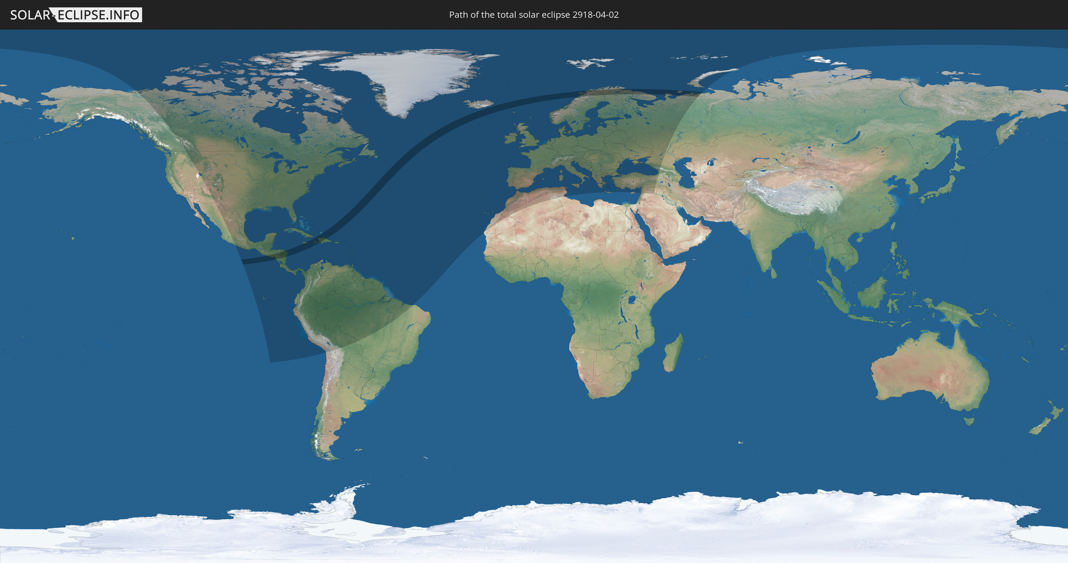
Die Sonnenfinsternis am 04/02/2918 kann man in 109 Ländern als partielle Sonnenfinsternis beobachten.
Der Finsternispfad verläuft durch 13 Länder. Nur in diesen Ländern ist sie als total Sonnenfinsternis zu sehen.
In den folgenden Ländern ist die Sonnenfinsternis total zu sehen
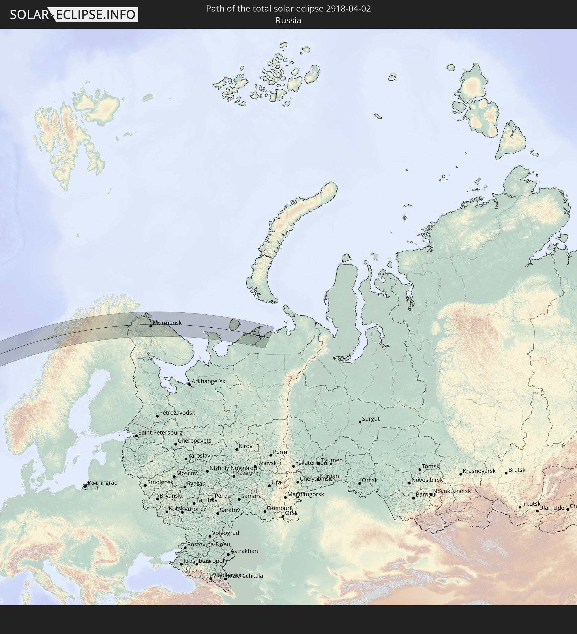 Russia
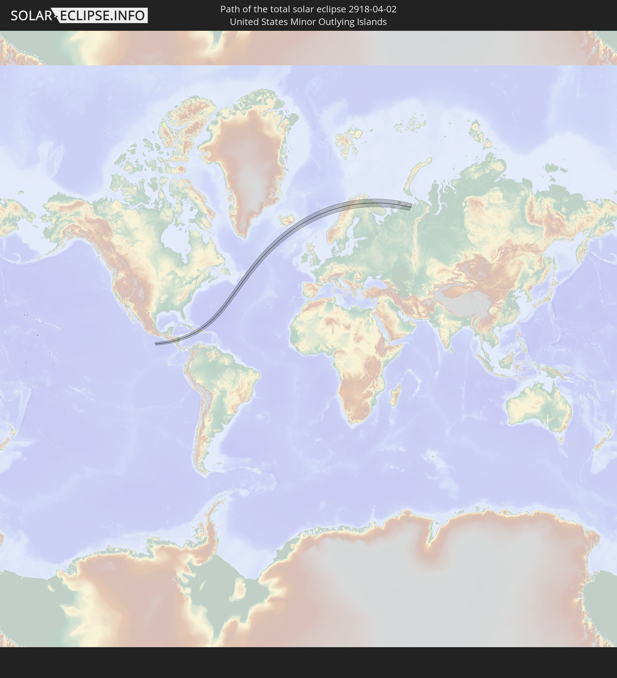 United States Minor Outlying Islands
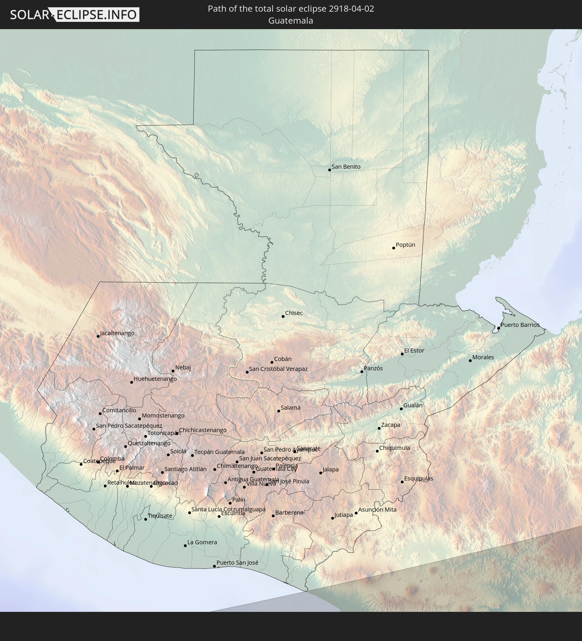 Guatemala
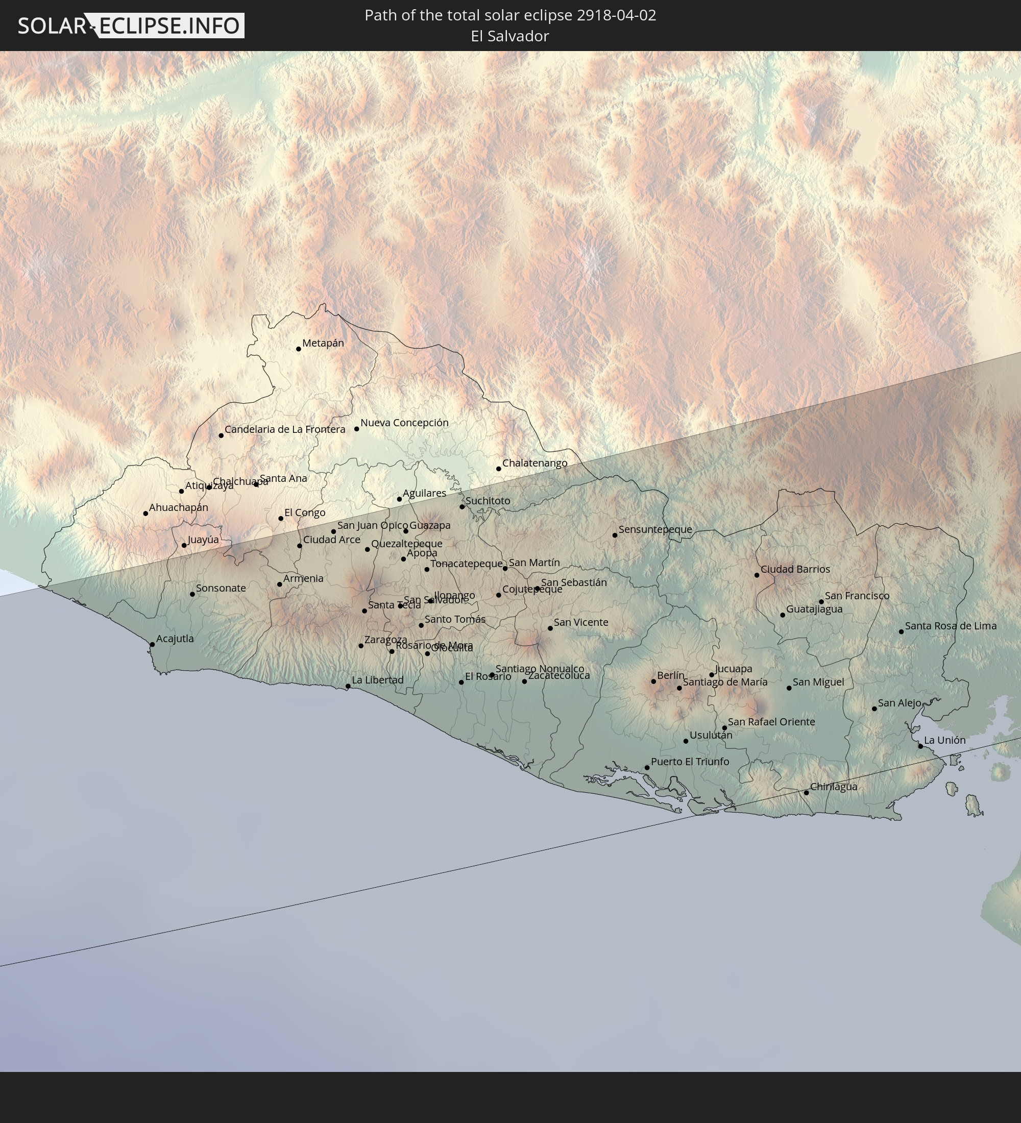 El Salvador
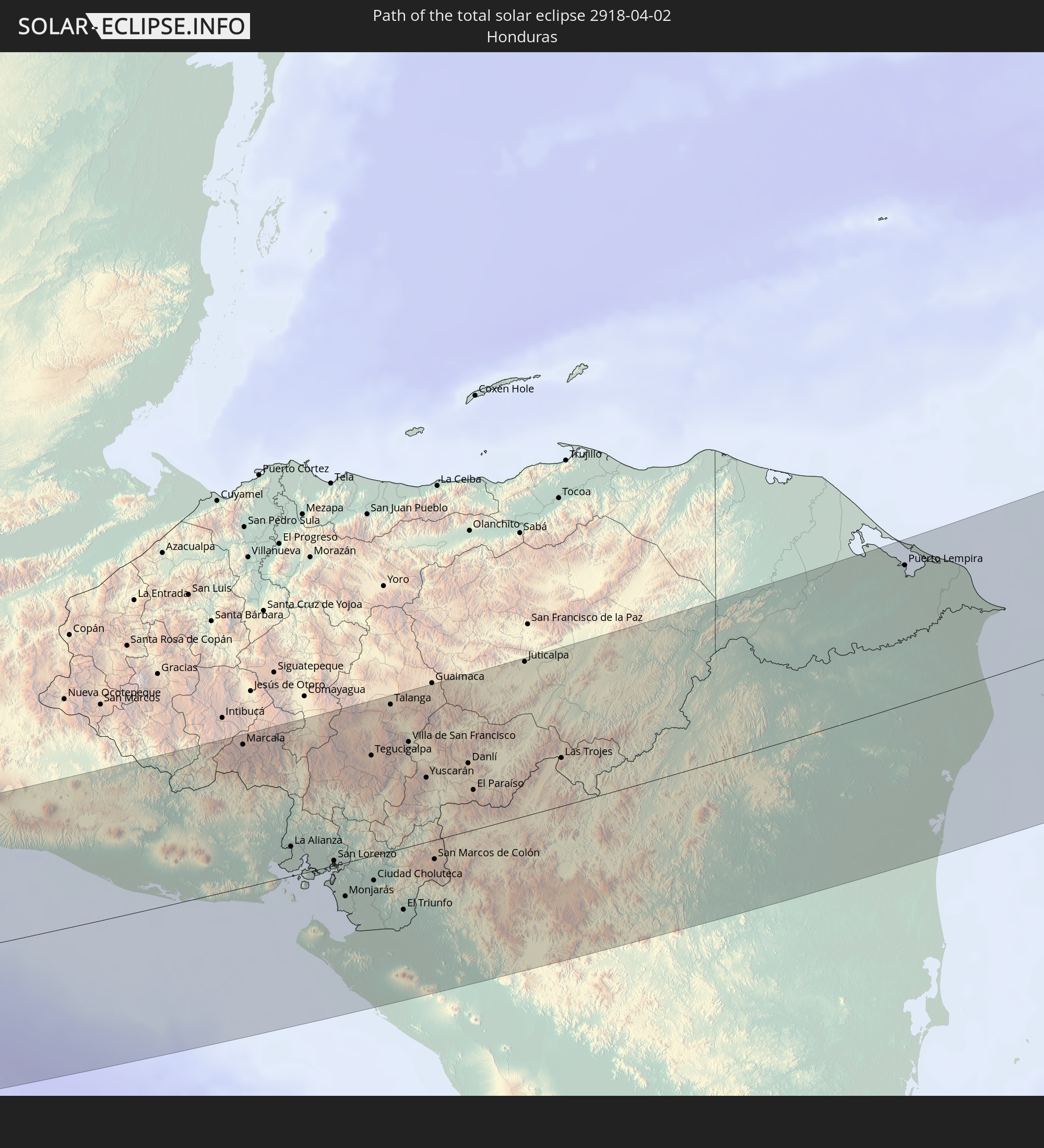 Honduras
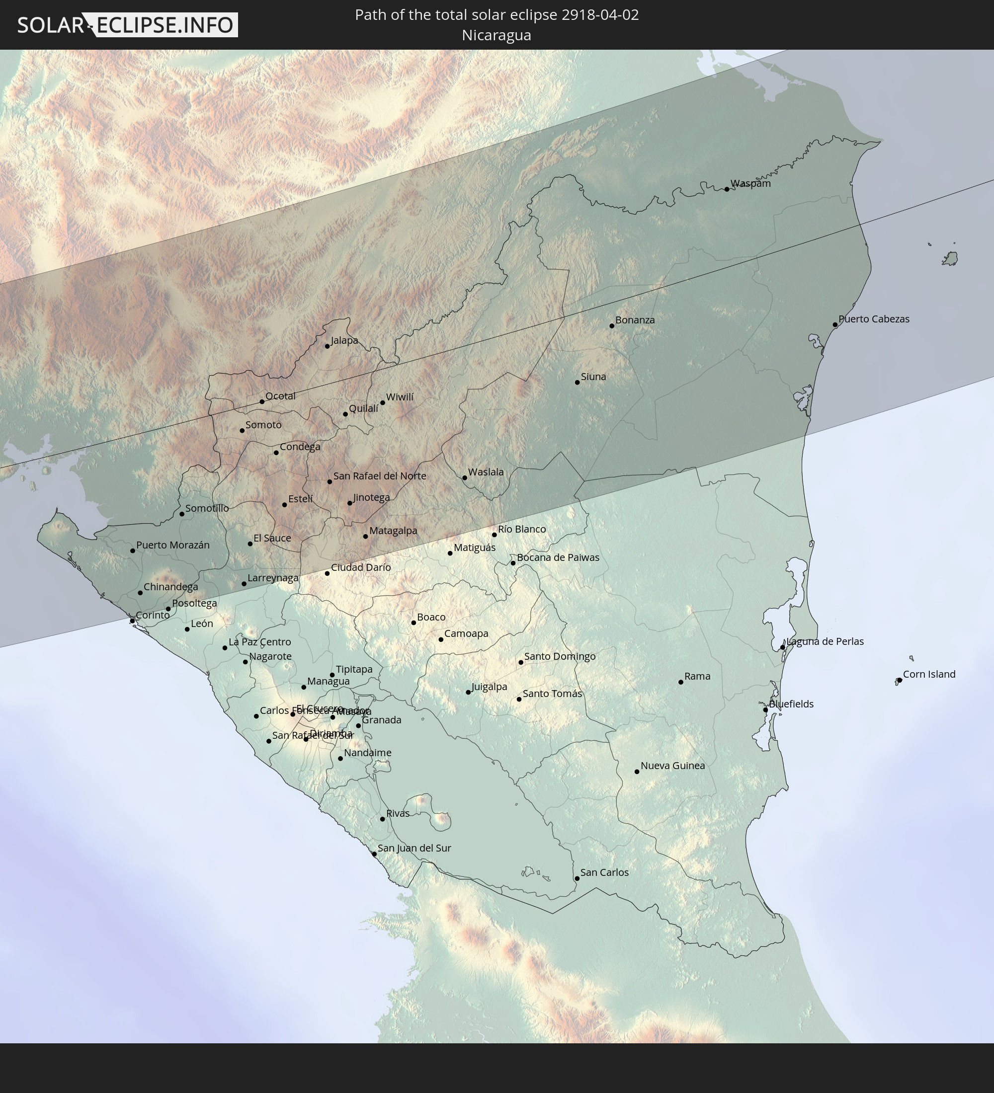 Nicaragua
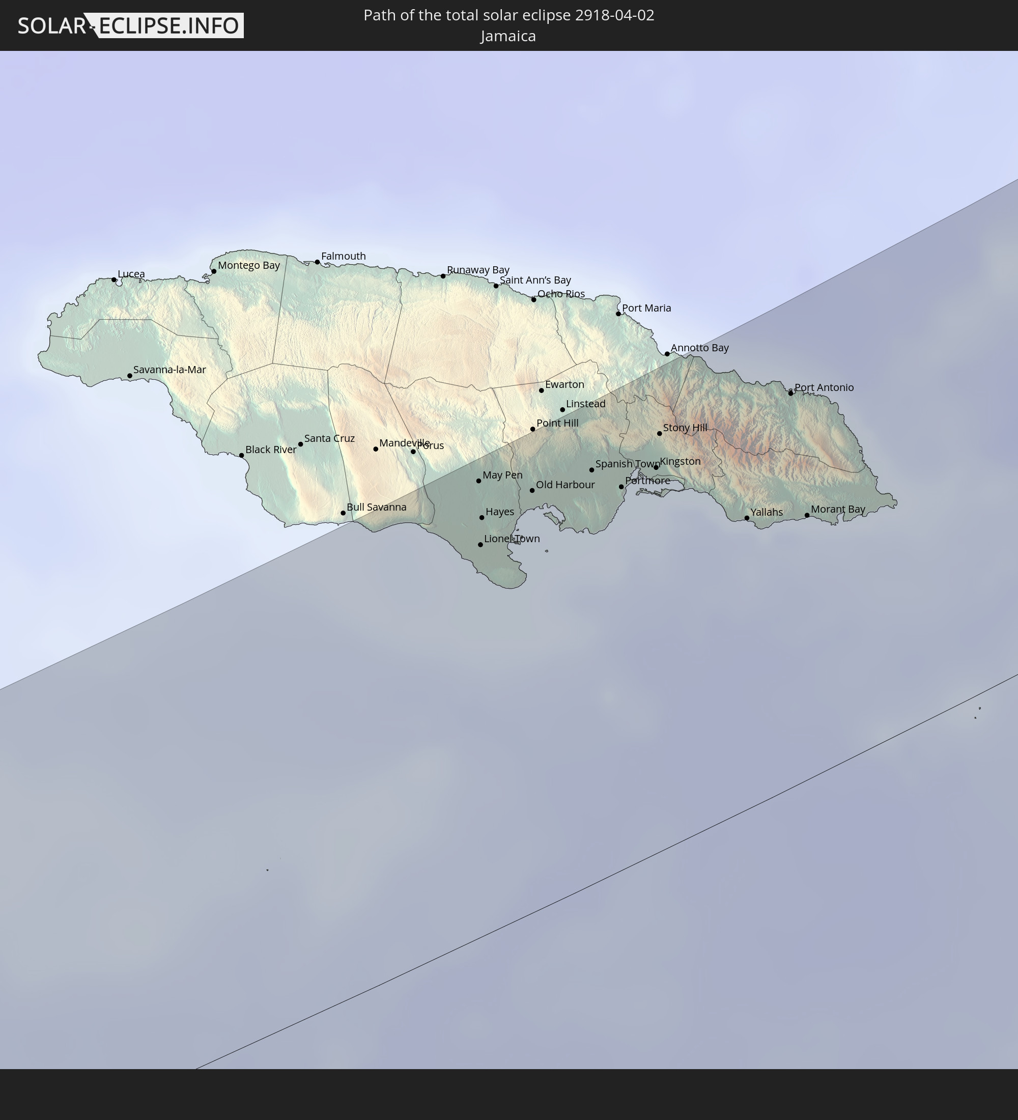 Jamaica
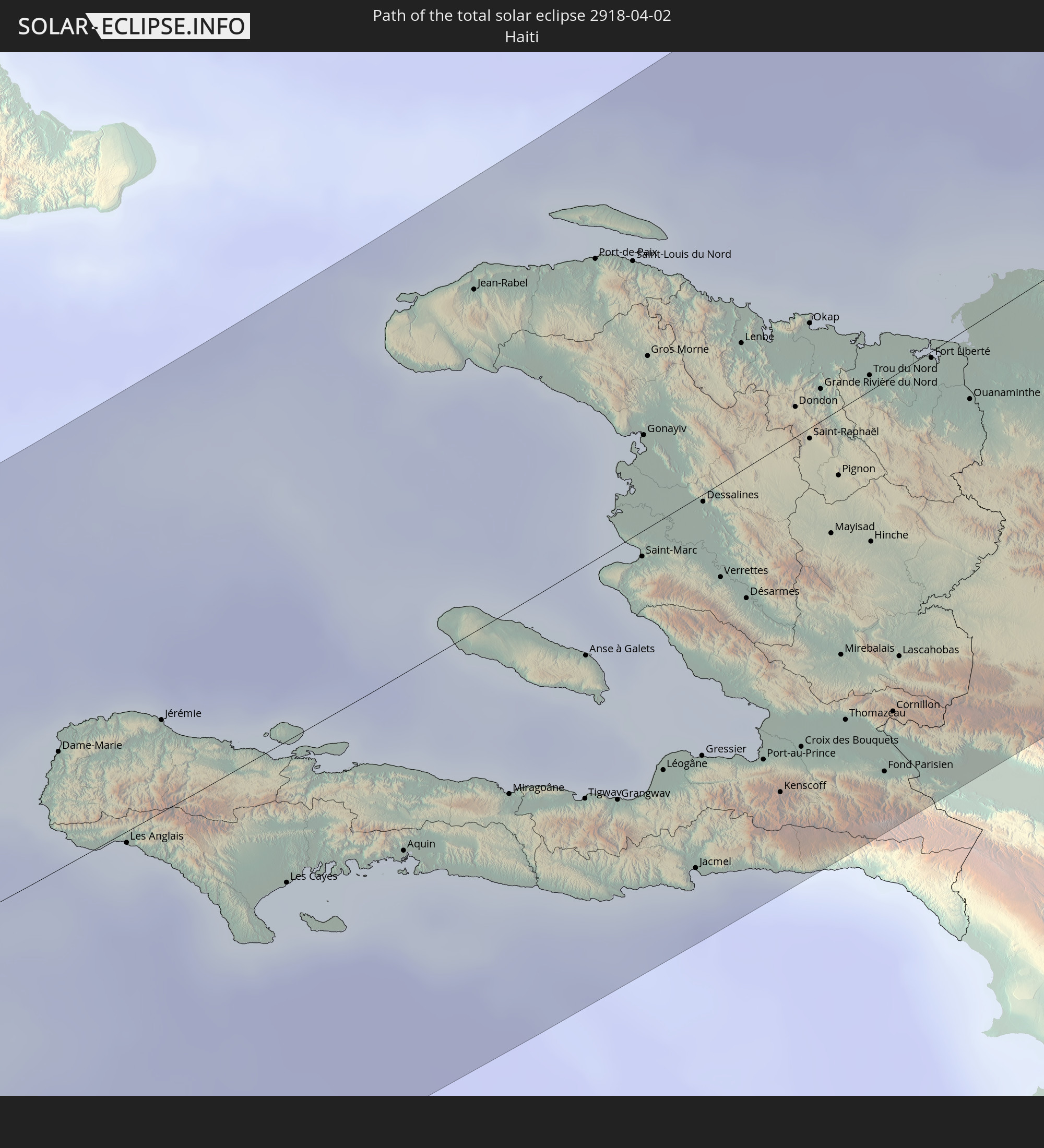 Haiti
Haiti
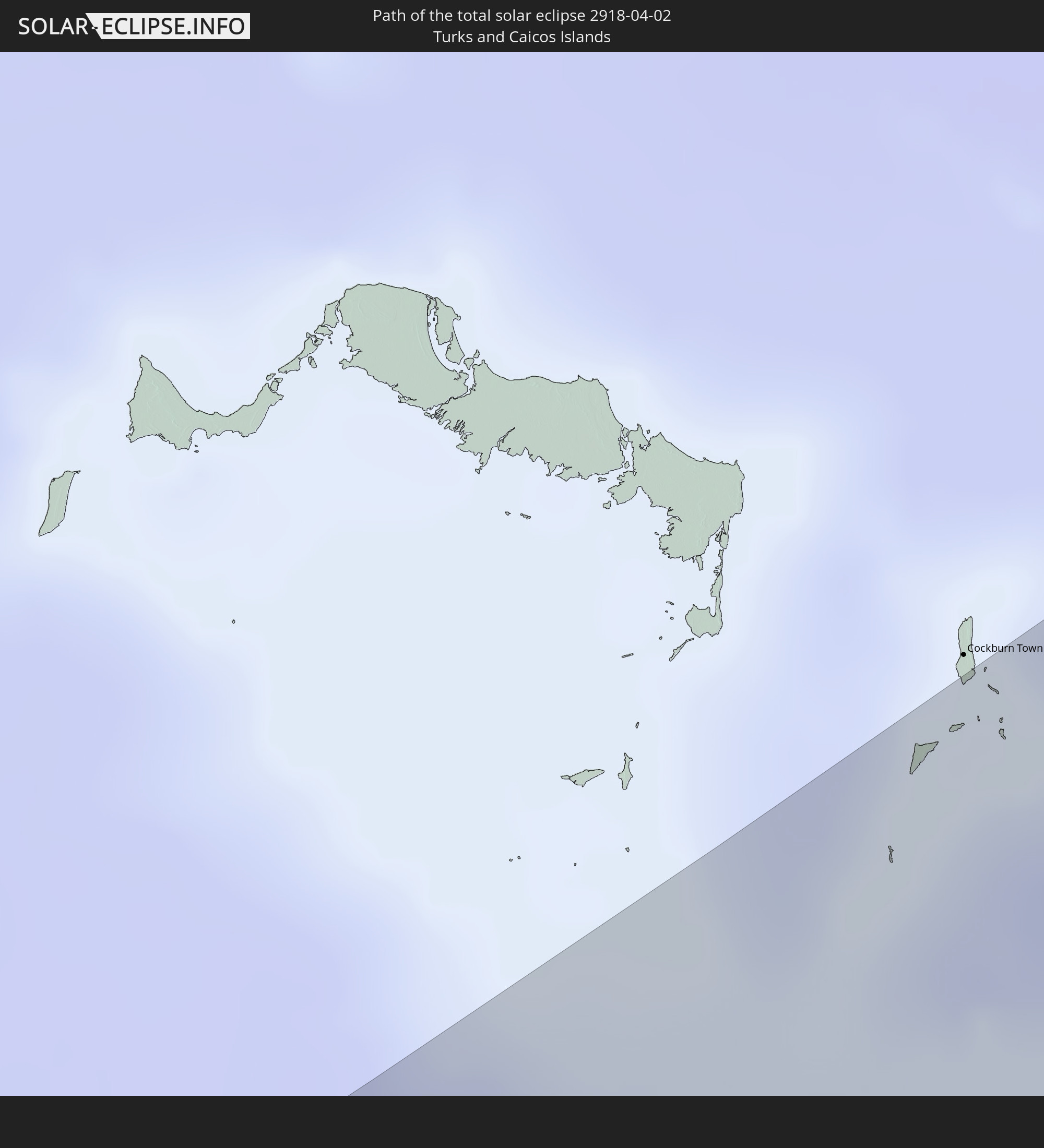 Turks and Caicos Islands
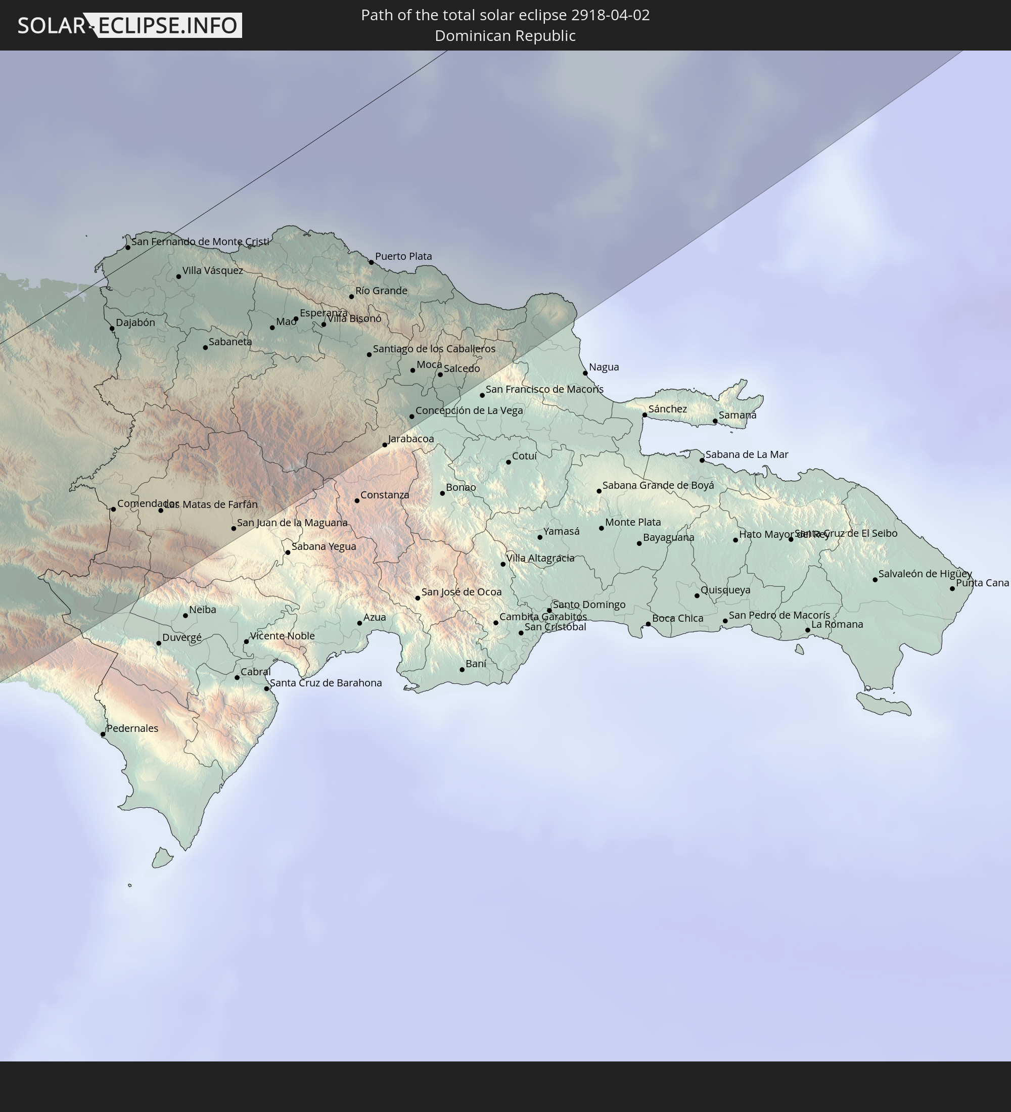 Dominican Republic
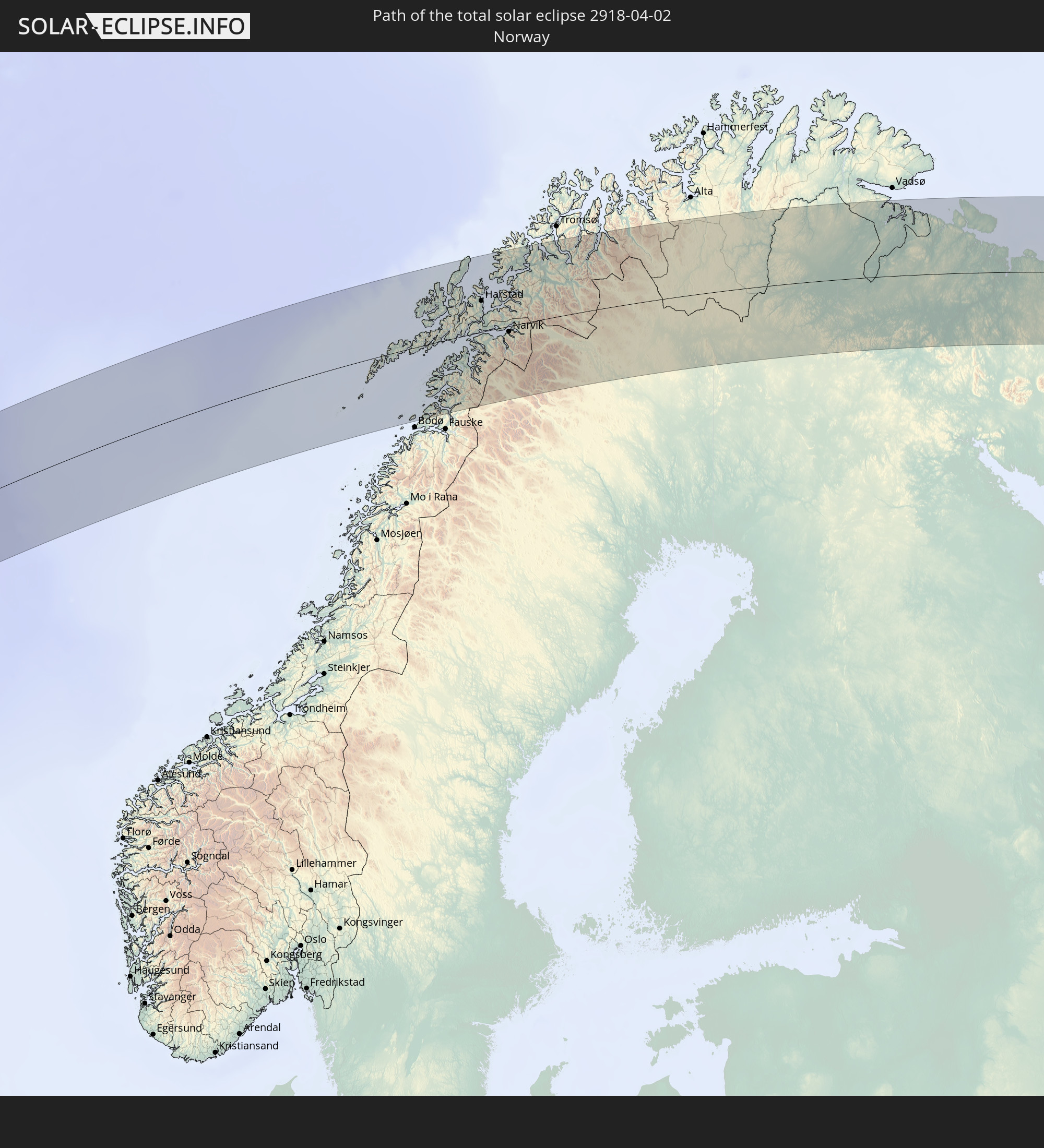 Norway
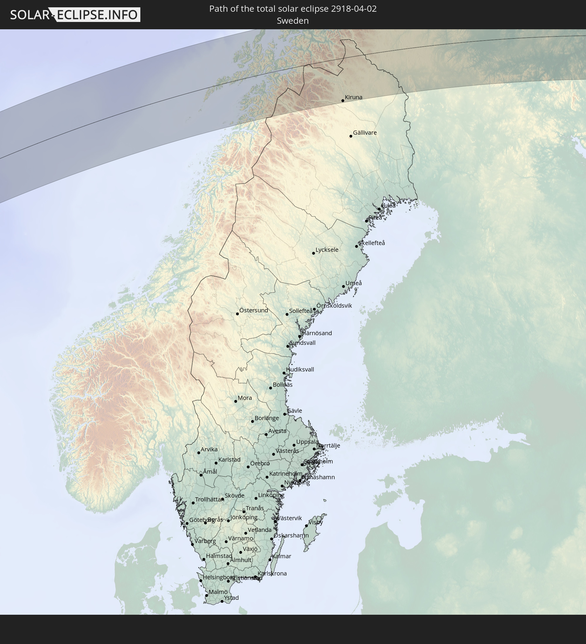 Sweden
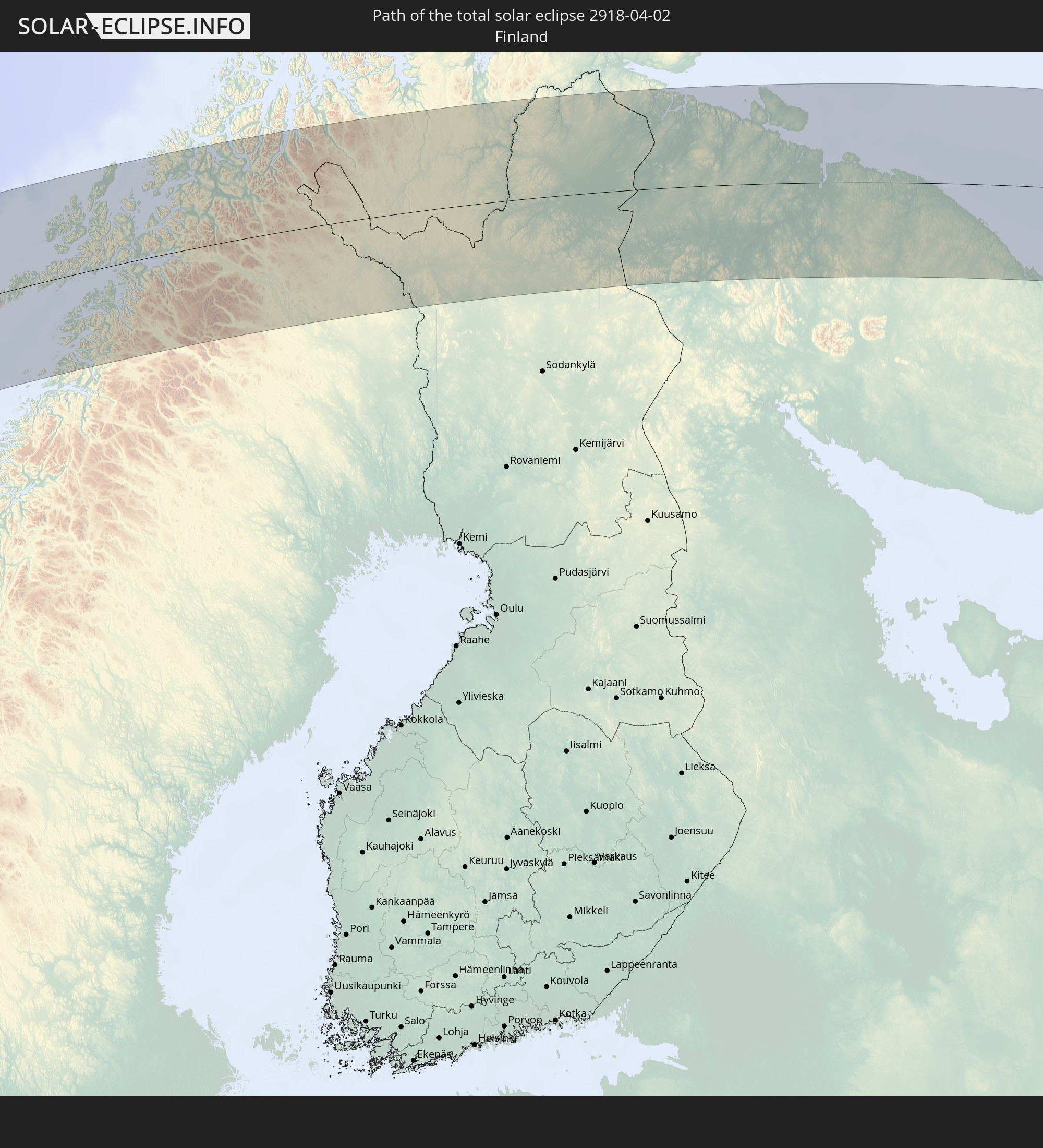 Finland
In den folgenden Ländern ist die Sonnenfinsternis partiell zu sehen
 Russia
 United States
 United States Minor Outlying Islands
 Canada
 Mexico
 Chile
Chile
 Greenland
 Guatemala
 Ecuador
 El Salvador
 Honduras
 Belize
 Nicaragua
 Costa Rica
 Cuba
Cuba
 Panama
 Colombia
 Cayman Islands
 Peru
Peru
 The Bahamas
 Jamaica
 Haiti
Haiti
 Brazil
 Venezuela
 Turks and Caicos Islands
 Dominican Republic
 Aruba
Aruba
 Bolivia
 Puerto Rico
 United States Virgin Islands
 Bermuda
 British Virgin Islands
 Anguilla
 Collectivity of Saint Martin
 Saint Barthélemy
 Saint Kitts and Nevis
 Antigua and Barbuda
 Montserrat
 Trinidad and Tobago
 Guadeloupe
 Grenada
 Dominica
 Saint Vincent and the Grenadines
 Guyana
 Martinique
 Saint Lucia
 Barbados
 Suriname
 Saint Pierre and Miquelon
 French Guiana
 Portugal
 Cabo Verde
 Iceland
 Spain
Spain
 Mauritania
 Morocco
 Republic of Ireland
 Svalbard and Jan Mayen
 Algeria
 United Kingdom
 Faroe Islands
 Gibraltar
 France
 Isle of Man
 Guernsey
 Jersey
 Andorra
 Belgium
 Netherlands
 Norway
 Luxembourg
 Germany
 Switzerland
 Italy
Italy
 Monaco
 Tunisia
 Denmark
 Liechtenstein
 Austria
 Sweden
 Czechia
 San Marino
 Vatican City
 Slovenia
 Croatia
 Poland
 Malta
Malta
 Bosnia and Herzegovina
 Hungary
 Slovakia
 Montenegro
 Serbia
 Albania
 Åland Islands
 Greece
 Romania
 Republic of Macedonia
 Finland
 Lithuania
 Latvia
 Estonia
 Ukraine
 Bulgaria
 Belarus
 Turkey
 Moldova
 Cyprus
 Syria
Syria
 Georgia
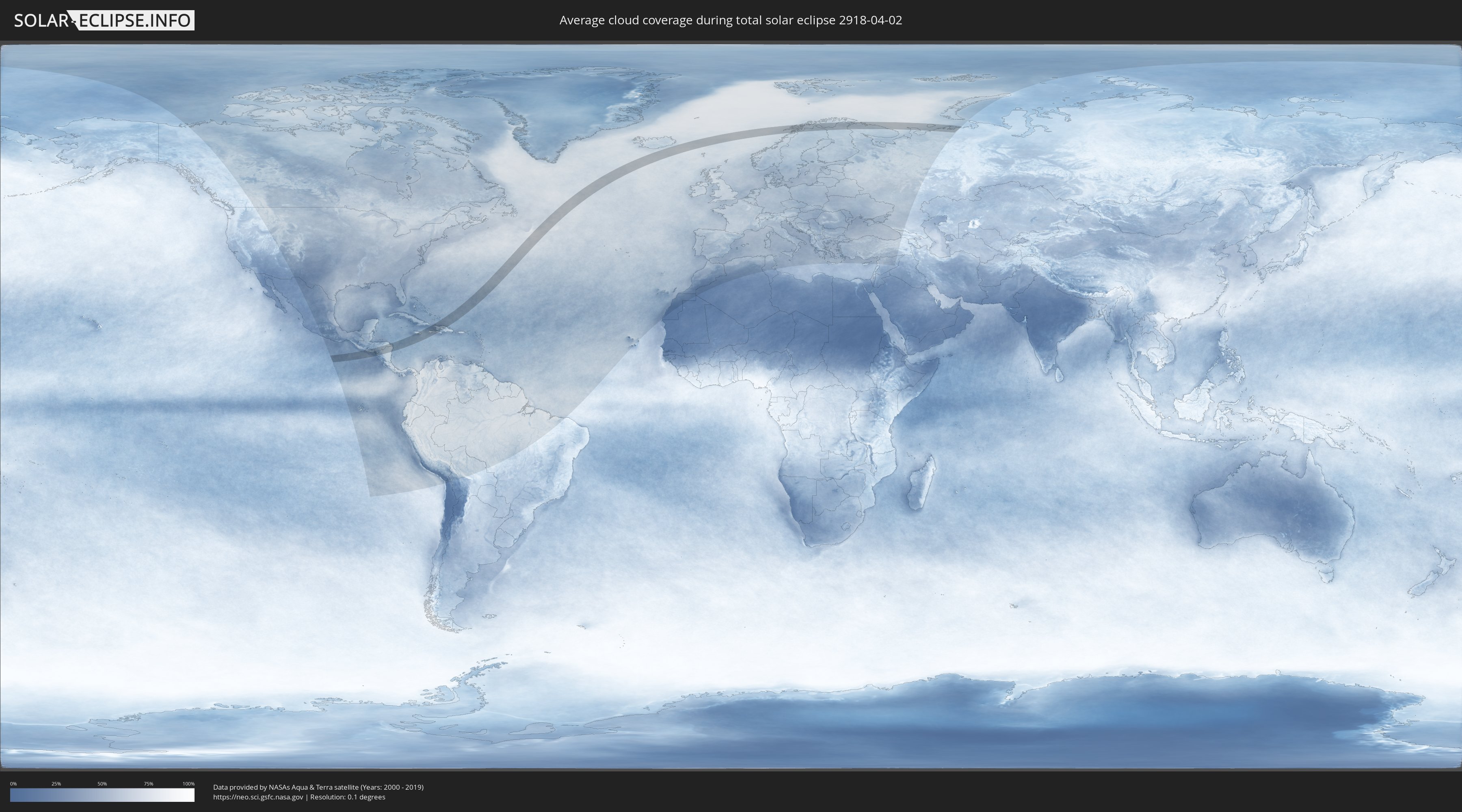
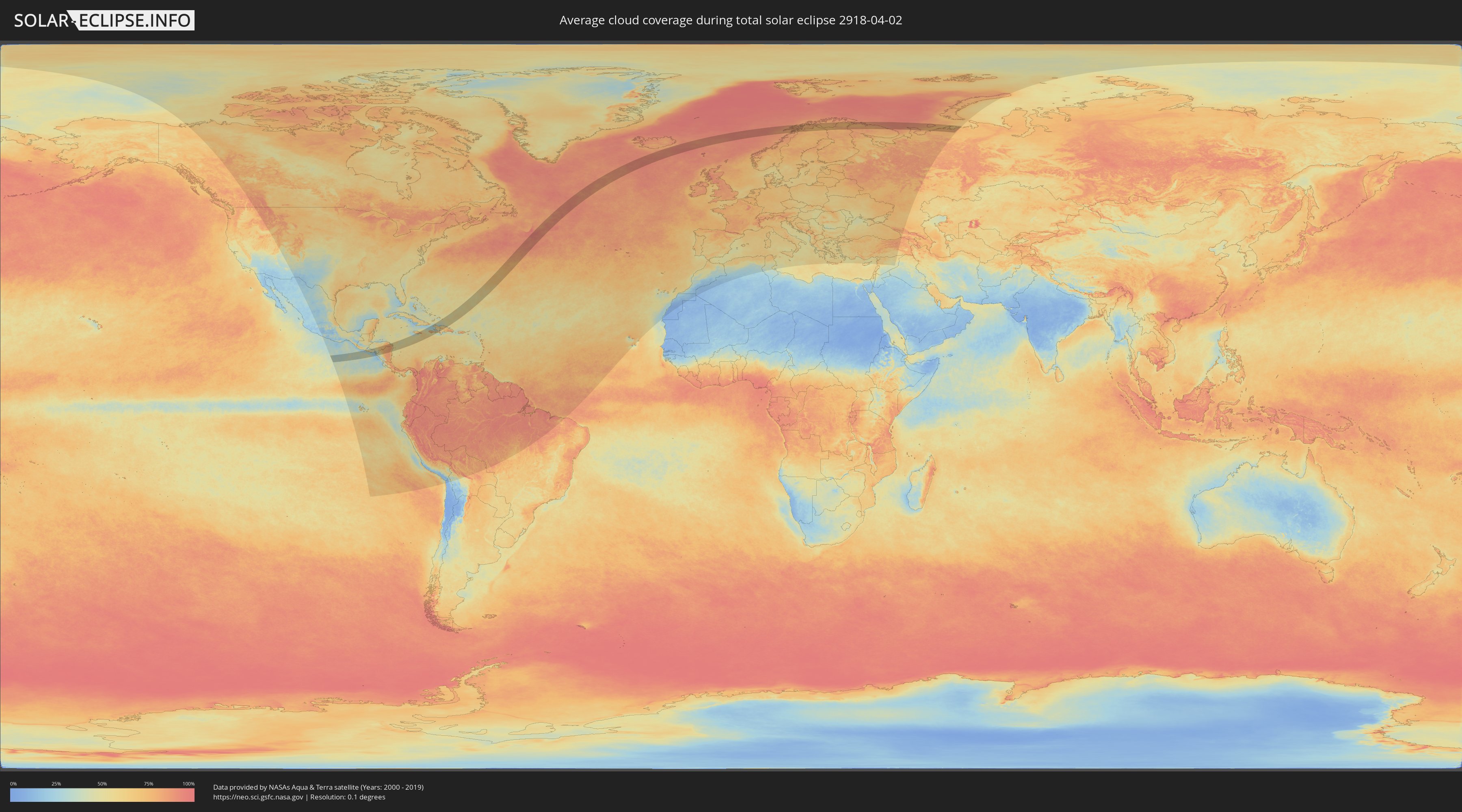
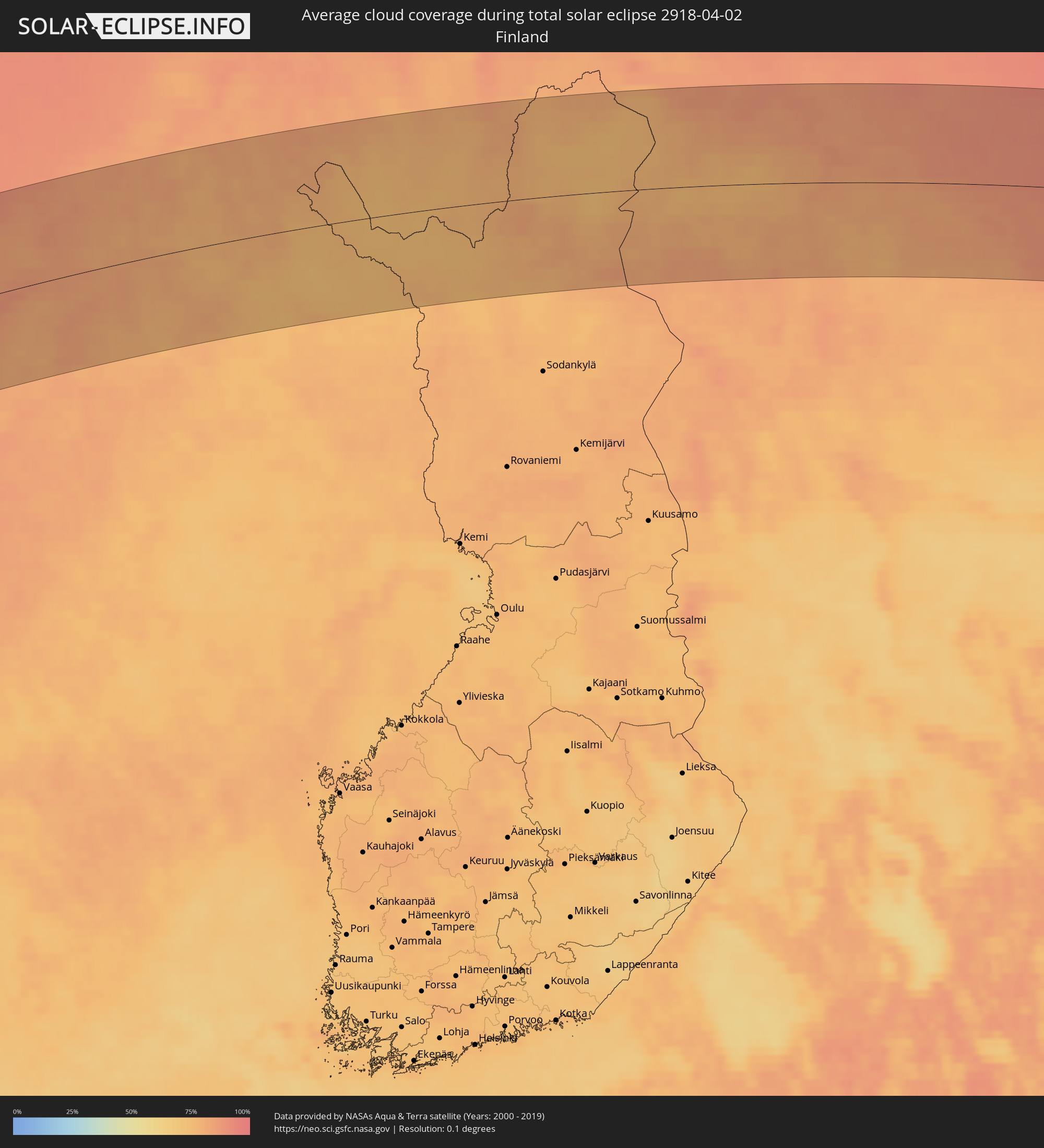
How will be the weather during the total solar eclipse on 04/02/2918?
Where is the best place to see the total solar eclipse of 04/02/2918?
The following maps show the average cloud coverage for the day of the total solar eclipse.
With the help of these maps, it is possible to find the place along the eclipse path, which has the best
chance of a cloudless sky.
Nevertheless, you should consider local circumstances and inform about the weather of your chosen
observation site.
The data is provided by NASAs satellites
AQUA and TERRA.
The cloud maps are averaged over a period of 19 years (2000 - 2019).
Detailed country maps
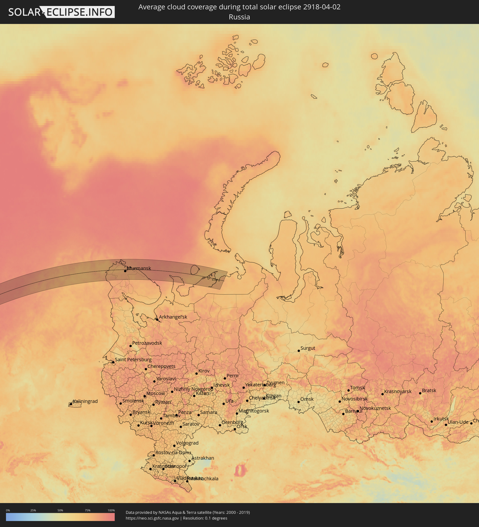 Russia
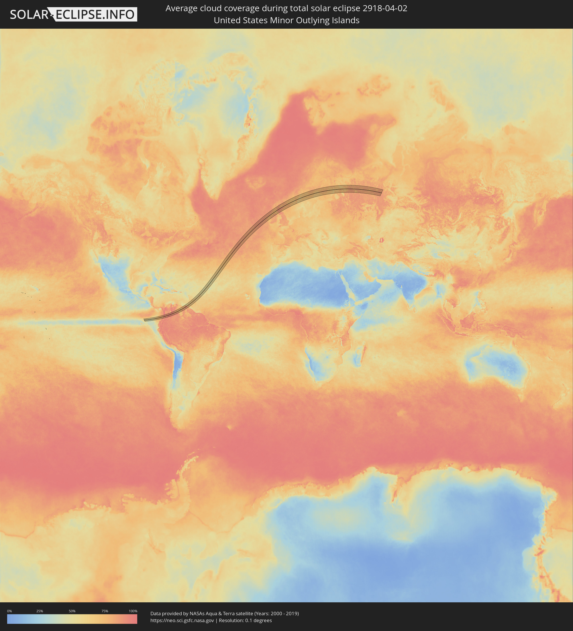 United States Minor Outlying Islands
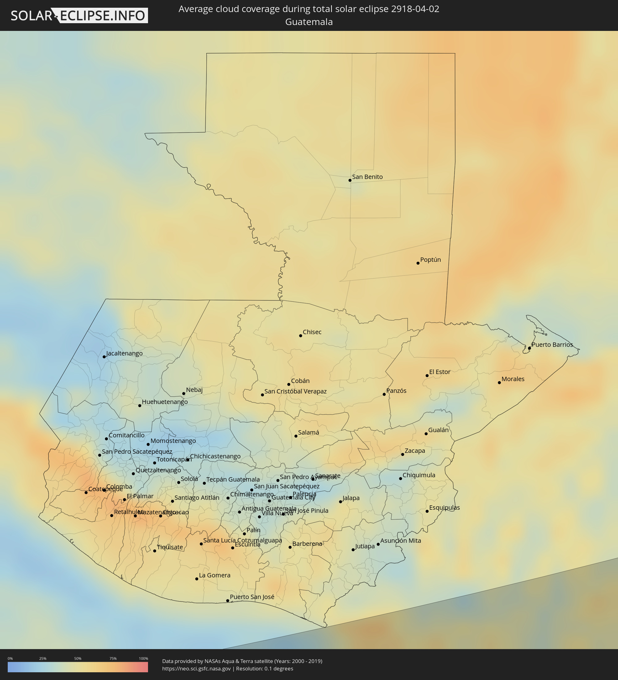 Guatemala
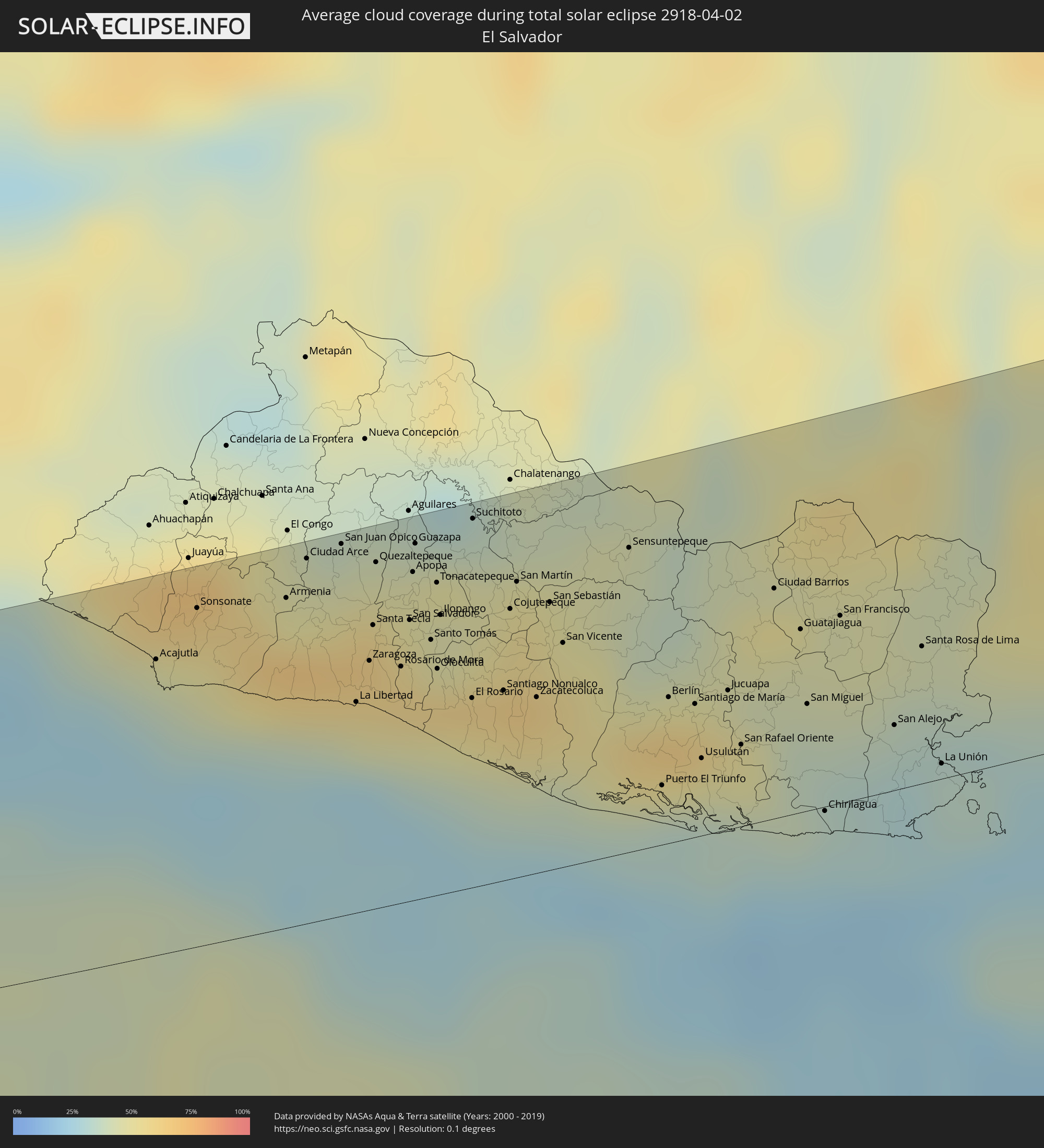 El Salvador
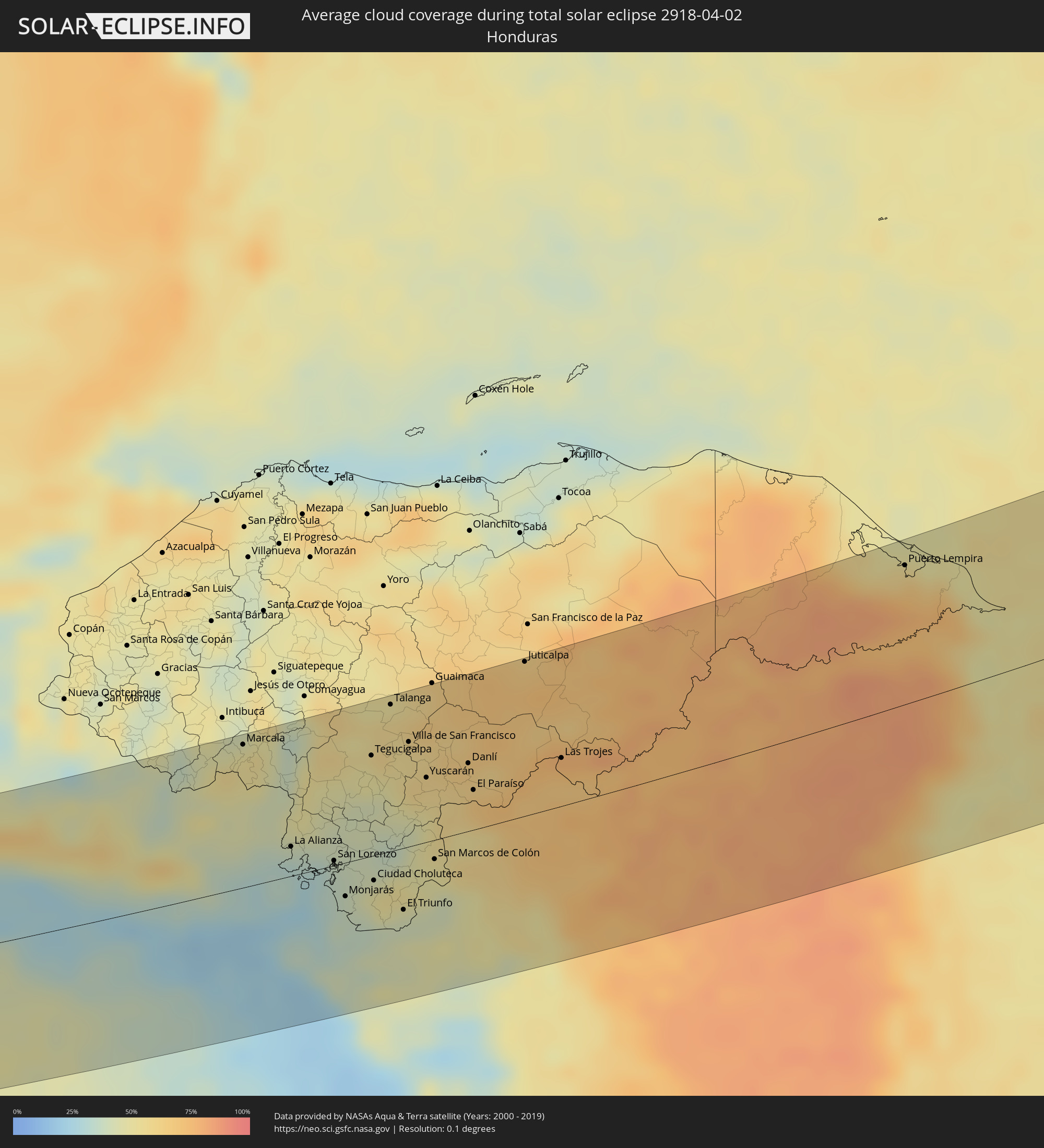 Honduras
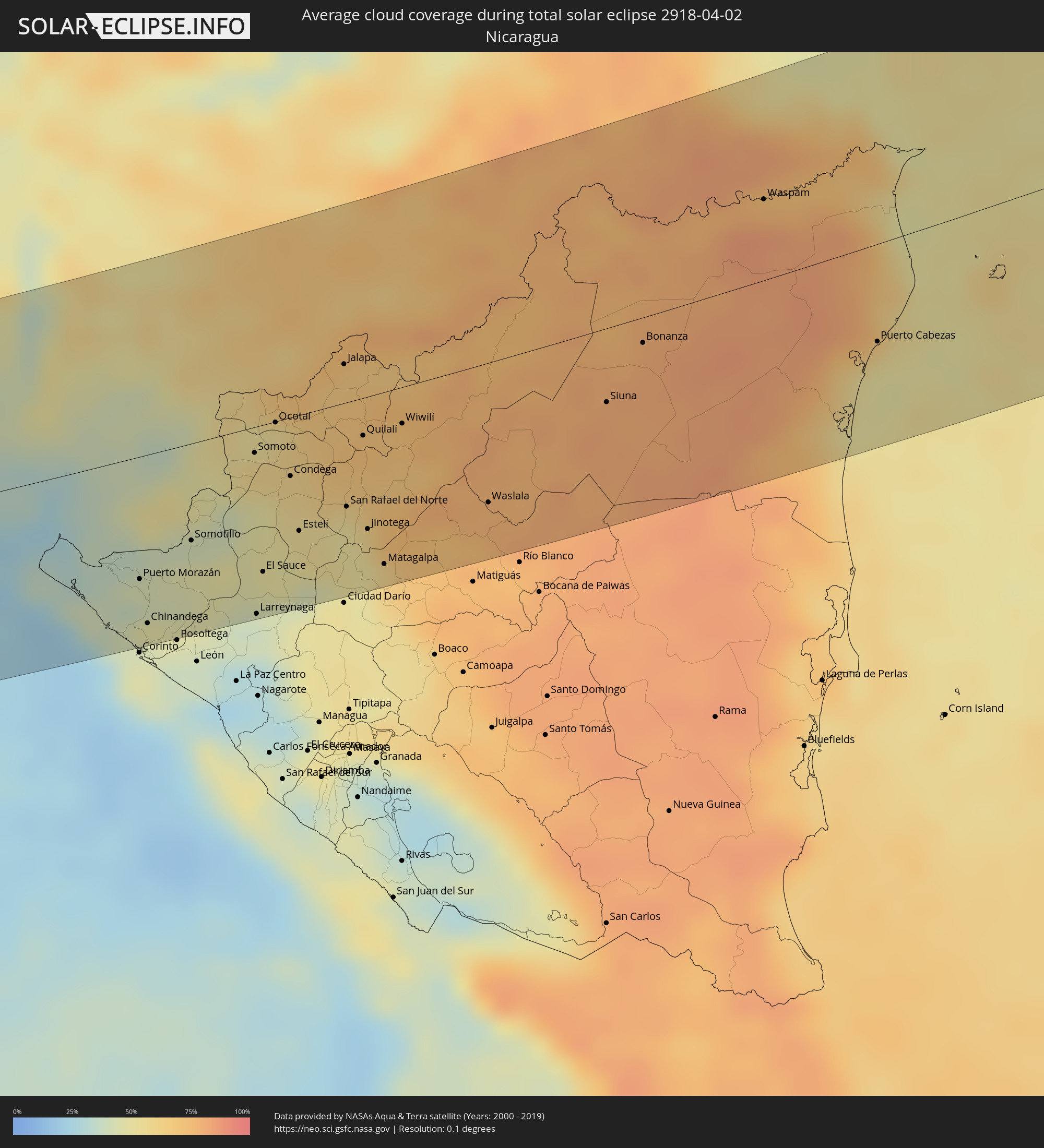 Nicaragua
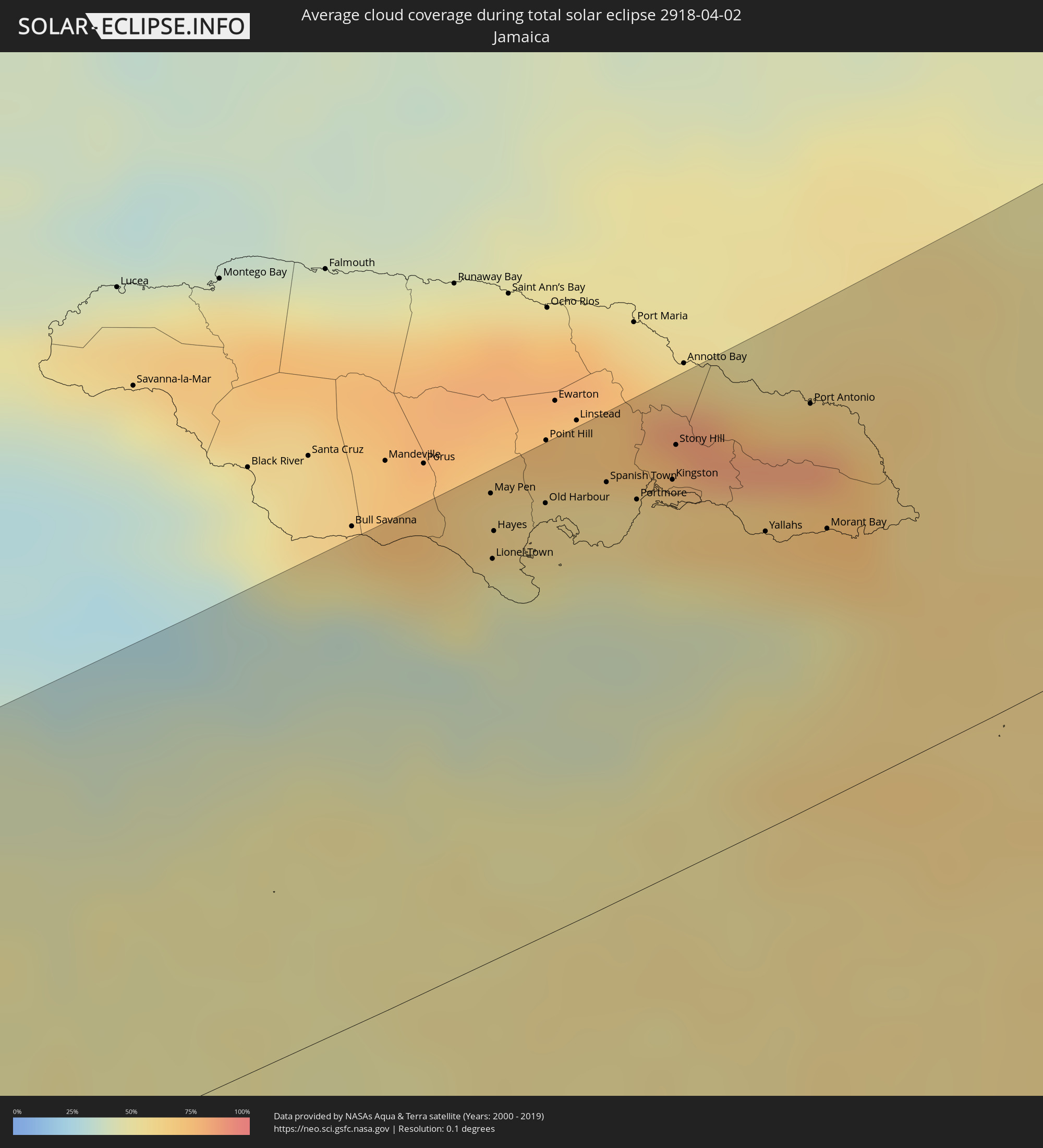 Jamaica
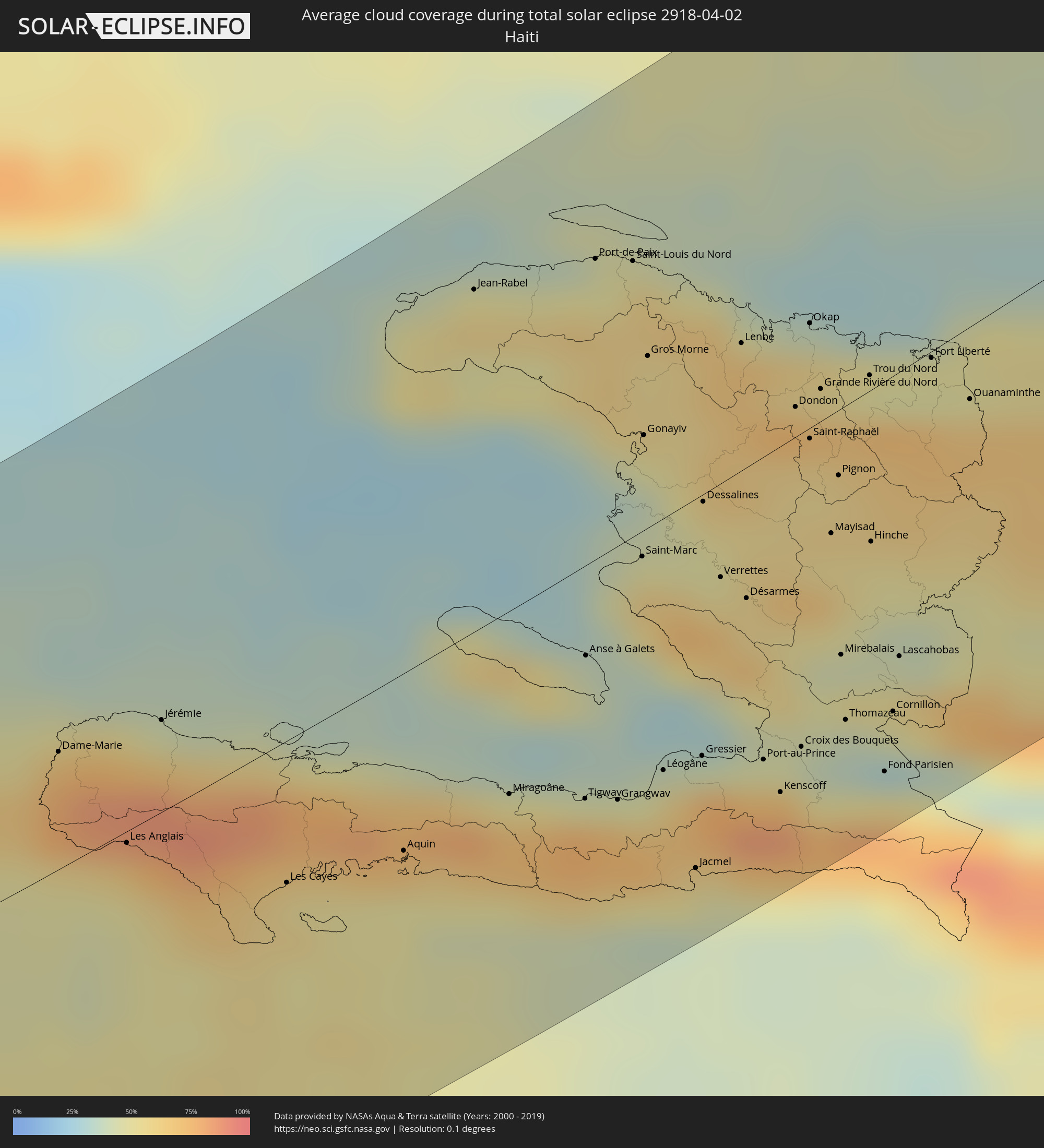 Haiti
Haiti
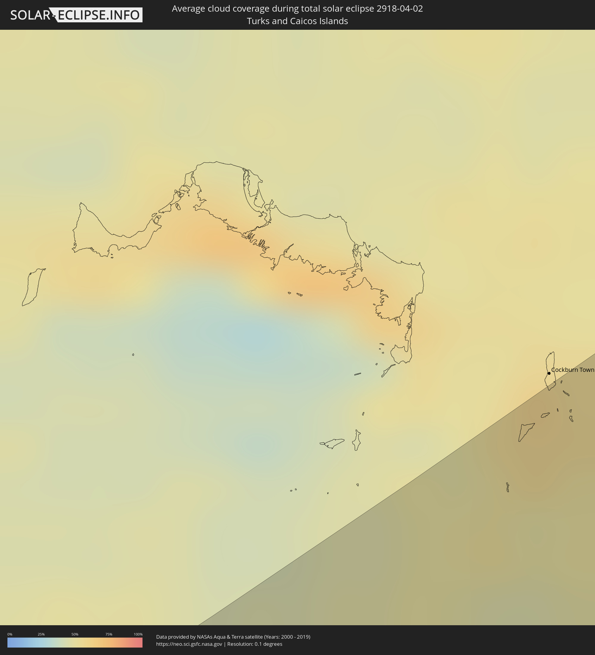 Turks and Caicos Islands
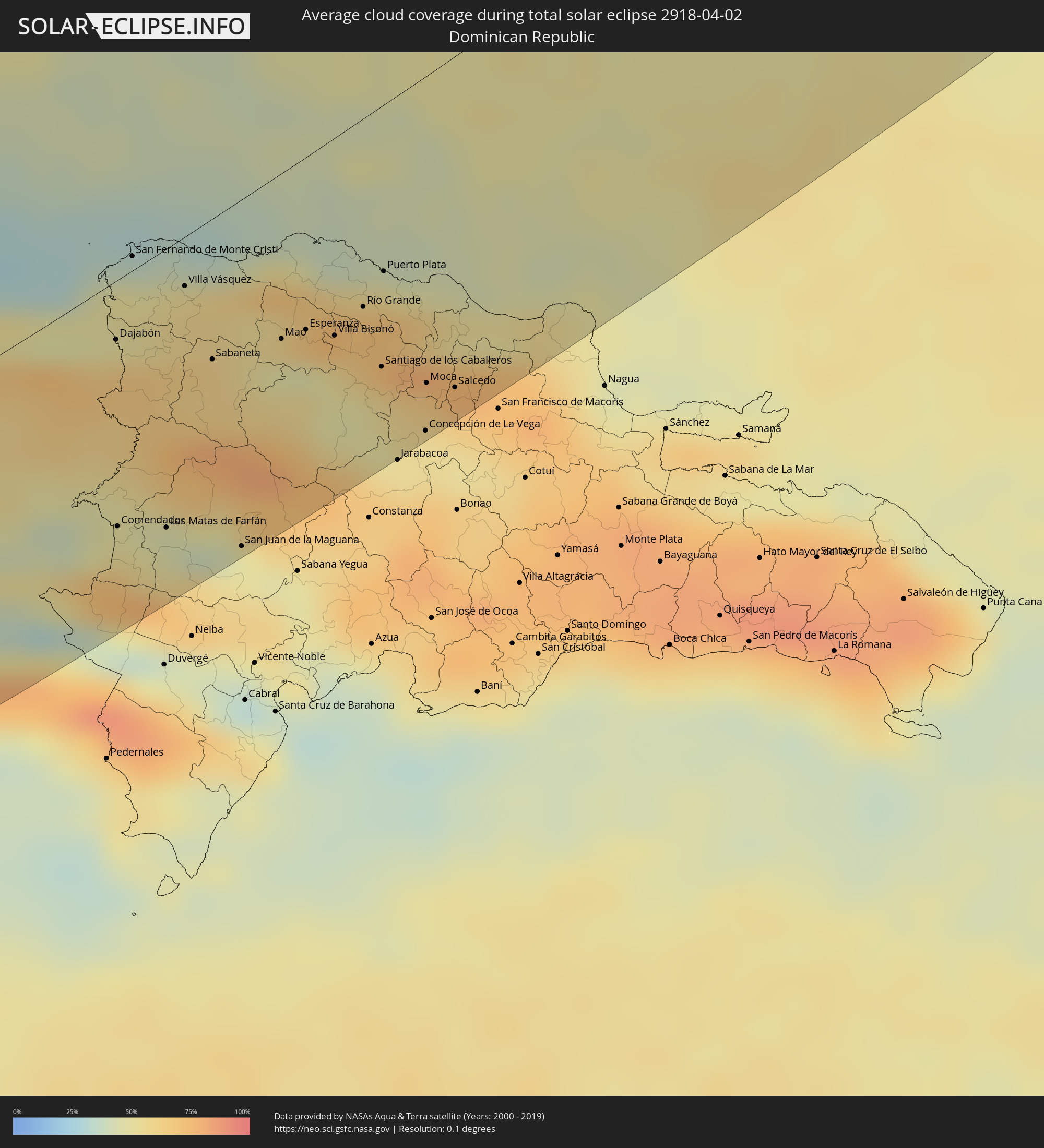 Dominican Republic
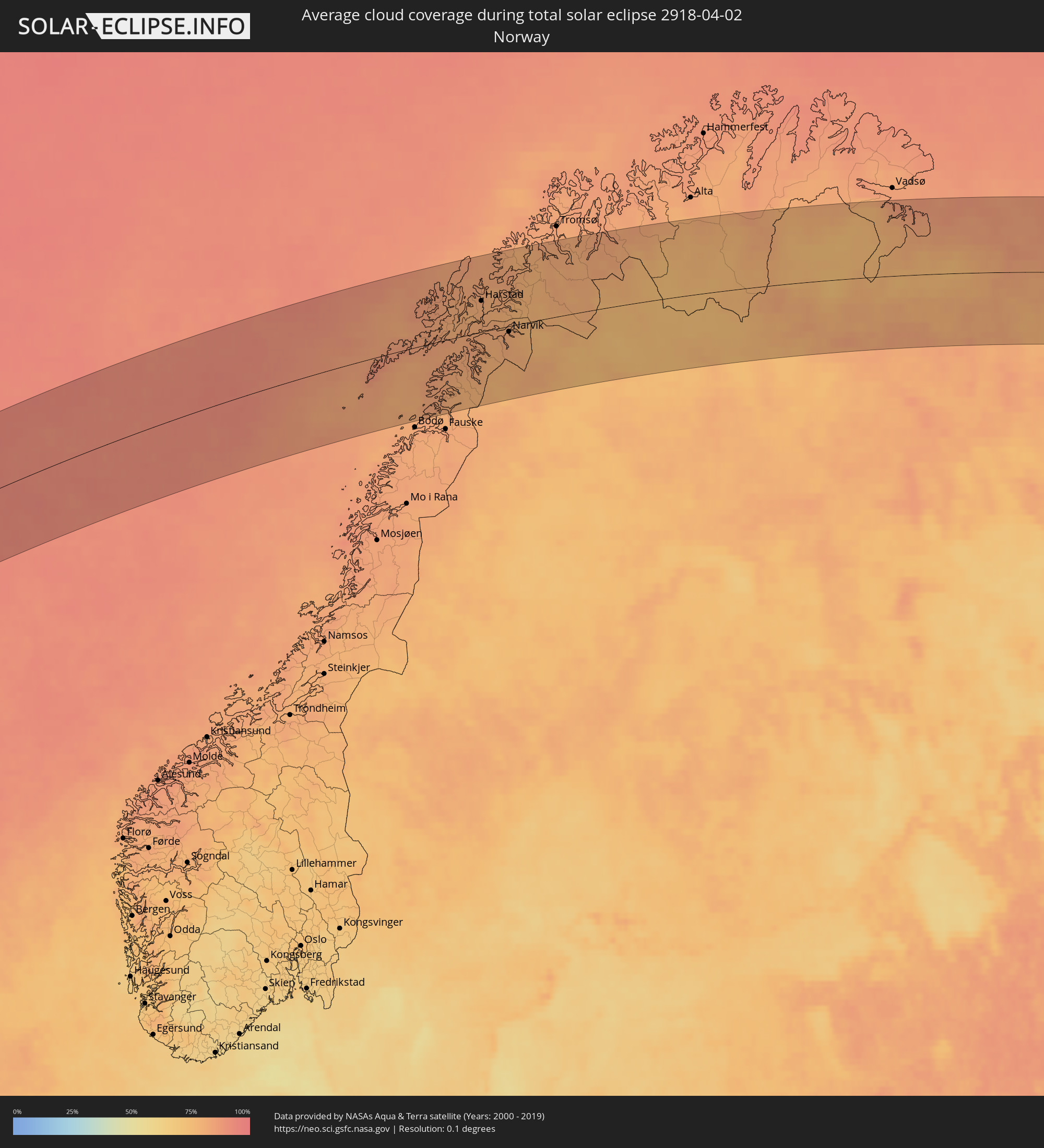 Norway
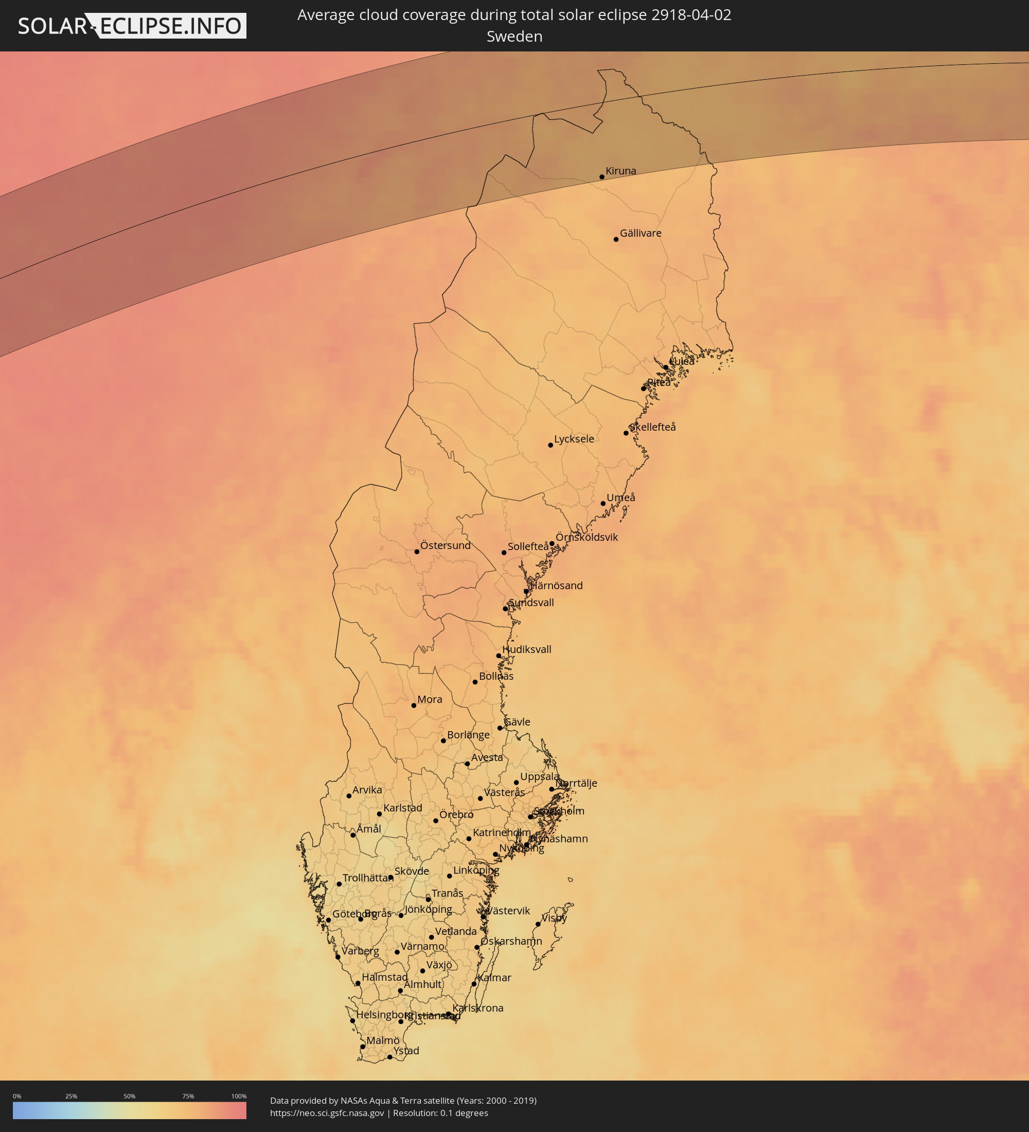 Sweden
 Finland
Cities inside the path of the eclipse
The following table shows all locations with a population of more than 5,000 inside the eclipse path. Cities which have more than 100,000 inhabitants are marked bold. A click at the locations opens a detailed map.
| City | Type | Eclipse duration | Local time of max. eclipse | Distance to central line | Ø Cloud coverage |
|
Acajutla, Sonsonate
|
total | - | 06:35:22 UTC-06:00 | 79 km | 40% |
|
Sonsonate, Sonsonate
|
total | - | 06:35:33 UTC-06:00 | 91 km | 52% |
|
Armenia, Sonsonate
|
total | - | 06:35:37 UTC-06:00 | 88 km | 65% |
|
La Libertad, La Libertad
|
total | - | 06:35:19 UTC-06:00 | 56 km | 44% |
|
Quezaltepeque, La Libertad
|
total | - | 06:35:46 UTC-06:00 | 93 km | 55% |
|
San Salvador, San Salvador
|
total | - | 06:35:36 UTC-06:00 | 75 km | 54% |
|
Cojutepeque, Cuscatlán
|
total | - | 06:35:41 UTC-06:00 | 72 km | 56% |
|
Zacatecoluca, La Paz
|
total | - | 06:35:24 UTC-06:00 | 47 km | 54% |
|
San Vicente, San Vicente
|
total | - | 06:35:35 UTC-06:00 | 60 km | 56% |
|
Sensuntepeque, Cabañas
|
total | - | 06:35:56 UTC-06:00 | 81 km | 41% |
|
Jiquilisco, Usulután
|
total | - | 06:35:12 UTC-06:00 | 20 km | 36% |
|
Berlín, Usulután
|
total | - | 06:35:27 UTC-06:00 | 39 km | 62% |
|
Usulután, Usulután
|
total | - | 06:35:16 UTC-06:00 | 21 km | 50% |
|
Jucuapa, Usulután
|
total | - | 06:35:30 UTC-06:00 | 37 km | 55% |
|
Chinameca, San Miguel
|
total | - | 06:35:29 UTC-06:00 | 34 km | 55% |
|
Ciudad Barrios, San Miguel
|
total | - | 06:35:51 UTC-06:00 | 61 km | 50% |
|
San Miguel, San Miguel
|
total | - | 06:35:30 UTC-06:00 | 28 km | 38% |
|
San Francisco, Morazán
|
total | - | 06:35:48 UTC-06:00 | 50 km | 45% |
|
Marcala, La Paz
|
total | - | 06:36:25 UTC-06:00 | 97 km | 51% |
|
Santa Rosa de Lima, La Unión
|
total | - | 06:35:44 UTC-06:00 | 36 km | 38% |
|
La Unión, La Unión
|
total | - | 06:35:22 UTC-06:00 | 4 km | 32% |
|
La Alianza, Valle
|
total | - | 06:35:37 UTC-06:00 | 20 km | 32% |
|
Villa de San Antonio, Comayagua
|
total | - | 06:36:44 UTC-06:00 | 104 km | 42% |
|
Nacaome, Valle
|
total | - | 06:35:42 UTC-06:00 | 16 km | 32% |
|
San Lorenzo, Valle
|
total | - | 06:35:33 UTC-06:00 | 3 km | 36% |
|
Monjarás, Choluteca
|
total | - | 06:35:16 UTC-06:00 | 23 km | 35% |
|
Tegucigalpa, Francisco Morazán
|
total | - | 06:36:30 UTC-06:00 | 68 km | 50% |
|
Ciudad Choluteca, Choluteca
|
total | - | 06:35:26 UTC-06:00 | 17 km | 46% |
|
Puerto Morazán, Chinandega
|
total | - | 06:34:50 UTC-06:00 | 66 km | 42% |
|
Chinandega, Chinandega
|
total | - | 06:34:33 UTC-06:00 | 91 km | 42% |
|
Talanga, Francisco Morazán
|
total | - | 06:36:58 UTC-06:00 | 99 km | 57% |
|
Chichigalpa, Chinandega
|
total | - | 06:34:30 UTC-06:00 | 99 km | 44% |
|
El Triunfo, Choluteca
|
total | - | 06:35:14 UTC-06:00 | 42 km | 40% |
|
Villa de San Francisco, Francisco Morazán
|
total | - | 06:36:40 UTC-06:00 | 71 km | 55% |
|
Somotillo, Chinandega
|
total | - | 06:35:09 UTC-06:00 | 52 km | 46% |
|
Yuscarán, El Paraíso
|
total | - | 06:36:23 UTC-06:00 | 43 km | 54% |
|
San Marcos de Colón, Choluteca
|
total | - | 06:35:42 UTC-06:00 | 13 km | 48% |
|
Campamento, Olancho
|
total | - | 06:37:16 UTC-06:00 | 103 km | 65% |
|
Danlí, El Paraíso
|
total | - | 06:36:34 UTC-06:00 | 46 km | 61% |
|
Somoto, Madriz
|
total | - | 06:35:49 UTC-06:00 | 14 km | 58% |
|
Larreynaga, León
|
total | - | 06:34:44 UTC-06:00 | 101 km | 38% |
|
El Paraíso, El Paraíso
|
total | - | 06:36:21 UTC-06:00 | 27 km | 60% |
|
El Sauce, León
|
total | - | 06:35:01 UTC-06:00 | 79 km | 48% |
|
Ocotal, Nueva Segovia
|
total | - | 06:36:03 UTC-06:00 | 1 km | 55% |
|
Condega, Estelí
|
total | - | 06:35:42 UTC-06:00 | 31 km | 59% |
|
Estelí, Estelí
|
total | - | 06:35:20 UTC-06:00 | 62 km | 51% |
|
Juticalpa, Olancho
|
total | - | 06:37:32 UTC-06:00 | 103 km | 67% |
|
Jalapa, Nueva Segovia
|
total | - | 06:36:32 UTC-06:00 | 21 km | 67% |
|
Quilalí, Nueva Segovia
|
total | - | 06:36:04 UTC-06:00 | 20 km | 72% |
|
Jinotega, Jinotega
|
total | - | 06:35:26 UTC-06:00 | 71 km | 55% |
|
Las Trojes, El Paraíso
|
total | - | 06:36:46 UTC-06:00 | 32 km | 72% |
|
Matagalpa, Matagalpa
|
total | - | 06:35:13 UTC-06:00 | 92 km | 62% |
|
Wiwilí, Nueva Segovia
|
total | - | 06:36:12 UTC-06:00 | 20 km | 71% |
|
Waslala, Atlántico Norte (RAAN)
|
total | - | 06:35:46 UTC-06:00 | 75 km | 77% |
|
Siuna, Atlántico Norte (RAAN)
|
total | - | 06:36:37 UTC-06:00 | 39 km | 81% |
|
Bonanza, Atlántico Norte (RAAN)
|
total | - | 06:37:05 UTC-06:00 | 13 km | 80% |
|
Waspam, Atlántico Norte (RAAN)
|
total | - | 06:38:17 UTC-06:00 | 43 km | 85% |
|
Puerto Lempira, Gracias a Dios
|
total | - | 06:39:06 UTC-06:00 | 92 km | 62% |
|
Puerto Cabezas, Atlántico Norte (RAAN)
|
total | - | 06:37:27 UTC-06:00 | 51 km | 51% |
|
May Pen, Clarendon
|
total | - | 07:46:05 UTC-05:00 | 111 km | 61% |
|
Lionel Town, Clarendon
|
total | - | 07:45:51 UTC-05:00 | 96 km | 42% |
|
Hayes, Clarendon
|
total | - | 07:45:57 UTC-05:00 | 102 km | 48% |
|
Old Harbour, Saint Catherine
|
total | - | 07:46:08 UTC-05:00 | 103 km | 50% |
|
Old Harbour Bay, Saint Catherine
|
total | - | 07:46:05 UTC-05:00 | 99 km | 50% |
|
Bog Walk, Saint Catherine
|
total | - | 07:46:27 UTC-05:00 | 114 km | 70% |
|
Spanish Town, Saint Catherine
|
total | - | 07:46:18 UTC-05:00 | 101 km | 57% |
|
Portmore, Saint Catherine
|
total | - | 07:46:16 UTC-05:00 | 93 km | 58% |
|
Half Way Tree, St. Andrew
|
total | - | 07:46:25 UTC-05:00 | 95 km | 63% |
|
Constant Spring, St. Andrew
|
total | - | 07:46:29 UTC-05:00 | 99 km | 75% |
|
Kingston, Kingston
|
total | - | 07:46:24 UTC-05:00 | 93 km | 63% |
|
Stony Hill, St. Andrew
|
total | - | 07:46:32 UTC-05:00 | 101 km | 75% |
|
New Kingston, St. Andrew
|
total | - | 07:46:25 UTC-05:00 | 94 km | 63% |
|
Yallahs, St. Thomas
|
total | - | 07:46:20 UTC-05:00 | 70 km | 55% |
|
Port Antonio, Portland
|
total | - | 07:46:53 UTC-05:00 | 95 km | 69% |
|
Morant Bay, St. Thomas
|
total | - | 07:46:25 UTC-05:00 | 64 km | 63% |
|
Jérémie, GrandʼAnse
|
total | - | 07:49:05 UTC-05:00 | 25 km | 46% |
|
Les Cayes, Sud
|
total | - | 07:48:34 UTC-05:00 | 39 km | 54% |
|
Miragoâne, Nippes
|
total | - | 07:49:25 UTC-05:00 | 49 km | 71% |
|
Tigwav, Ouest
|
total | - | 07:49:32 UTC-05:00 | 62 km | 75% |
|
Port-de-Paix, Nord-Ouest
|
total | - | 07:52:08 UTC-05:00 | 80 km | 50% |
|
Saint-Louis du Nord, Nord-Ouest
|
total | - | 07:52:12 UTC-05:00 | 73 km | 58% |
|
Saint-Marc, Artibonite
|
total | - | 07:50:48 UTC-05:00 | 7 km | 60% |
|
Gonayiv, Artibonite
|
total | - | 07:51:23 UTC-05:00 | 25 km | 39% |
|
Léogâne, Ouest
|
total | - | 07:49:50 UTC-05:00 | 67 km | 62% |
|
Jacmel, Sud-Est
|
total | - | 07:49:26 UTC-05:00 | 99 km | 46% |
|
Dessalines, Artibonite
|
total | - | 07:51:12 UTC-05:00 | 2 km | 52% |
|
Verrettes, Artibonite
|
total | - | 07:50:52 UTC-05:00 | 25 km | 55% |
|
Lenbe, Nord
|
total | - | 07:52:02 UTC-05:00 | 34 km | 65% |
|
Port-au-Prince, Ouest
|
total | - | 07:50:05 UTC-05:00 | 81 km | 70% |
|
Okap, Nord
|
total | - | 07:52:16 UTC-05:00 | 28 km | 38% |
|
Saint-Raphaël, Nord
|
total | - | 07:51:43 UTC-05:00 | 3 km | 56% |
|
Thomazeau, Ouest
|
total | - | 07:50:27 UTC-05:00 | 83 km | 41% |
|
Hinche, Centre
|
total | - | 07:51:21 UTC-05:00 | 40 km | 52% |
|
Fond Parisien, Ouest
|
total | - | 07:50:17 UTC-05:00 | 103 km | 54% |
|
Fort Liberté, Nord-Est
|
total | - | 07:52:22 UTC-05:00 | 2 km | 49% |
|
Dajabón, Dajabón
|
total | - | 08:52:15 UTC-04:00 | 20 km | 67% |
|
Comendador, Elías Piña
|
total | - | 08:51:06 UTC-04:00 | 83 km | 53% |
|
San Fernando de Monte Cristi, Monte Cristi
|
total | - | 08:52:49 UTC-04:00 | 5 km | 49% |
|
Las Matas de Farfán, San Juan
|
total | - | 08:51:14 UTC-04:00 | 94 km | 46% |
|
Las Matas de Santa Cruz, Monte Cristi
|
total | - | 08:52:37 UTC-04:00 | 20 km | 56% |
|
Villa Vásquez, Monte Cristi
|
total | - | 08:52:47 UTC-04:00 | 16 km | 59% |
|
Sabaneta, Santiago Rodríguez
|
total | - | 08:52:24 UTC-04:00 | 47 km | 61% |
|
San Juan de la Maguana, San Juan
|
total | - | 08:51:20 UTC-04:00 | 117 km | 50% |
|
Mao, Valverde
|
total | - | 08:52:43 UTC-04:00 | 55 km | 48% |
|
San José de Las Matas, Santiago
|
total | - | 08:52:28 UTC-04:00 | 83 km | 57% |
|
Villa Bisonó, Santiago
|
total | - | 08:52:54 UTC-04:00 | 66 km | 52% |
|
Imbert, Puerto Plata
|
total | - | 08:53:16 UTC-04:00 | 51 km | 57% |
|
Villa González, Santiago
|
total | - | 08:52:55 UTC-04:00 | 73 km | 51% |
|
Río Grande, Puerto Plata
|
total | - | 08:53:09 UTC-04:00 | 62 km | 70% |
|
Santiago de los Caballeros, Santiago
|
total | - | 08:52:50 UTC-04:00 | 86 km | 57% |
|
Puerto Plata, Puerto Plata
|
total | - | 08:53:26 UTC-04:00 | 55 km | 56% |
|
Concepción de La Vega, La Vega
|
total | - | 08:52:34 UTC-04:00 | 117 km | 56% |
|
Moca, Espaillat
|
total | - | 08:52:52 UTC-04:00 | 102 km | 60% |
|
Salsipuedes, Hermanas Mirabal
|
total | - | 08:53:00 UTC-04:00 | 109 km | 65% |
|
Río San Juan, María Trinidad Sánchez
|
total | - | 08:53:38 UTC-04:00 | 105 km | 68% |
|
Harstad, Troms
|
total | - | 16:05:08 UTC+01:00 | 40 km | 80% |
|
Narvik, Nordland
|
total | - | 16:05:46 UTC+01:00 | 7 km | 80% |
|
Kiruna, Norrbotten
|
total | - | 16:07:12 UTC+01:00 | 92 km | 74% |
|
Inari, Lapland
|
total | - | 17:07:43 UTC+02:00 | 12 km | 79% |
|
Nikel, Murmansk
|
total | - | 18:07:43 UTC+03:00 | 35 km | 80% |
|
Zapolyarnyy, Murmansk
|
total | - | 18:07:48 UTC+03:00 | 35 km | 76% |
|
Zaozërsk, Murmansk
|
total | - | 18:08:04 UTC+03:00 | 31 km | 80% |
|
Vidyayevo, Murmansk
|
total | - | 18:08:13 UTC+03:00 | 21 km | 81% |
|
Murmashi, Murmansk
|
total | - | 18:08:48 UTC+03:00 | 35 km | 81% |
|
Vidyayevo, Murmansk
|
total | - | 18:08:45 UTC+03:00 | 27 km | 81% |
|
Kola, Murmansk
|
total | - | 18:08:45 UTC+03:00 | 28 km | 81% |
|
Molochnyy, Murmansk
|
total | - | 18:08:47 UTC+03:00 | 31 km | 81% |
|
Murmansk, Murmansk
|
total | - | 18:08:39 UTC+03:00 | 17 km | 81% |
|
Roslyakovo, Murmansk
|
total | - | 18:08:35 UTC+03:00 | 10 km | 81% |
|
Snezhnogorsk, Murmansk
|
total | - | 18:08:25 UTC+03:00 | 7 km | 82% |
|
Gadzhiyevo, Murmansk
|
total | - | 18:08:21 UTC+03:00 | 14 km | 81% |
|
Severomorsk, Murmansk
|
total | - | 18:08:35 UTC+03:00 | 7 km | 82% |
|
Polyarnyy, Murmansk
|
total | - | 18:08:26 UTC+03:00 | 8 km | 83% |
|
Nar'yan-Mar, Nenetskiy Avtonomnyy Okrug
|
total | - | 18:10:49 UTC+03:00 | 85 km | 77% |
|
Iskateley, Nenetskiy Avtonomnyy Okrug
|
total | - | 18:10:46 UTC+03:00 | 79 km | 78% |