Totale Sonnenfinsternis vom 15.04.2963
| Wochentag: | Freitag |
| Maximale Dauer der Verfinsterung: | 03m44s |
| Maximale Breite des Finsternispfades: | 273 km |
| Saroszyklus: | 154 |
| Bedeckungsgrad: | 100% |
| Magnitude: | 1.0547 |
| Gamma: | 0.7513 |
Wo kann man die Sonnenfinsternis vom 15.04.2963 sehen?
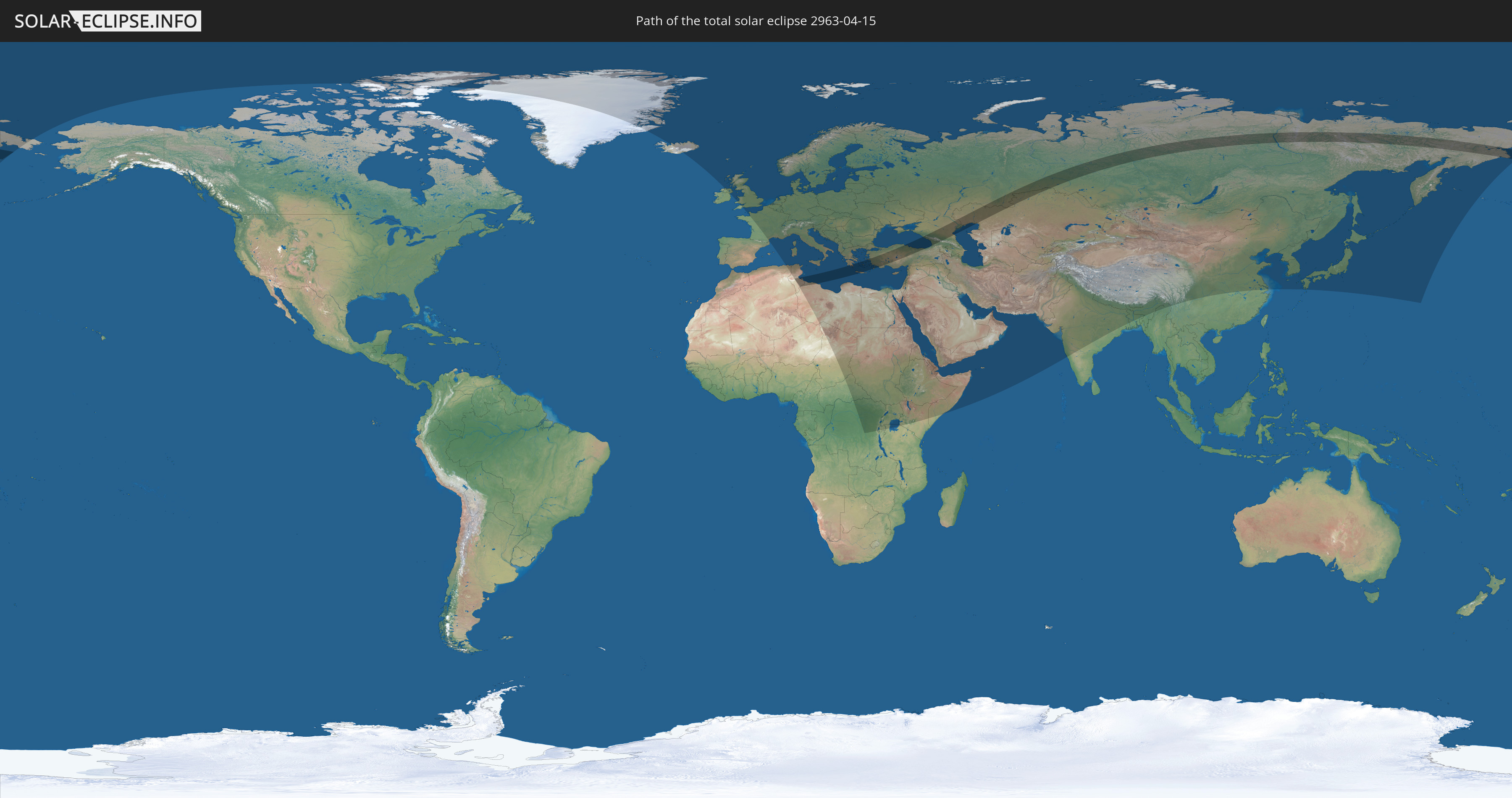
Die Sonnenfinsternis am 15.04.2963 kann man in 101 Ländern als partielle Sonnenfinsternis beobachten.
Der Finsternispfad verläuft durch 7 Länder. Nur in diesen Ländern ist sie als totale Sonnenfinsternis zu sehen.
In den folgenden Ländern ist die Sonnenfinsternis total zu sehen
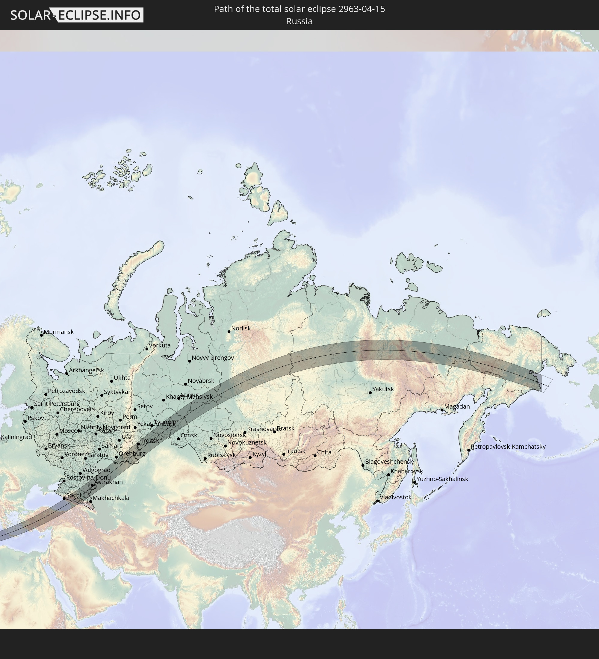 Russland
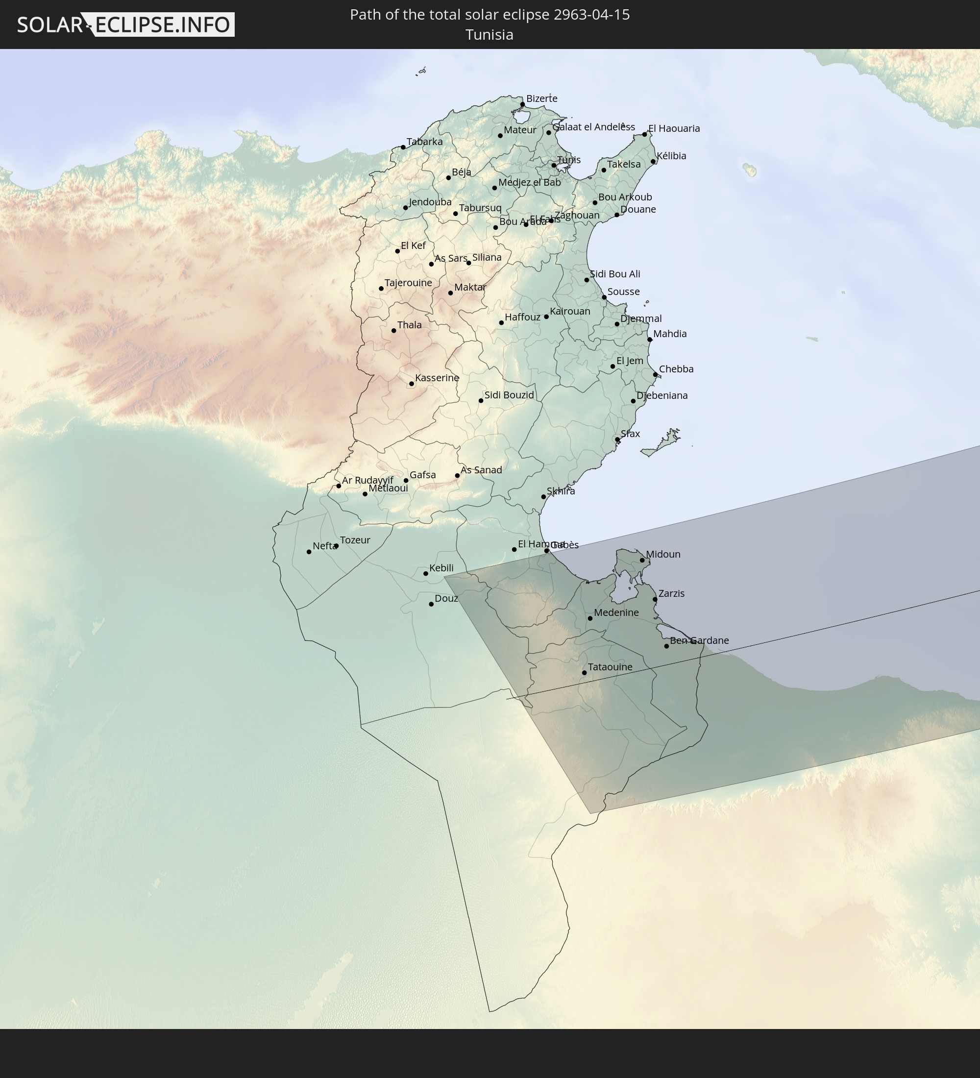 Tunesien
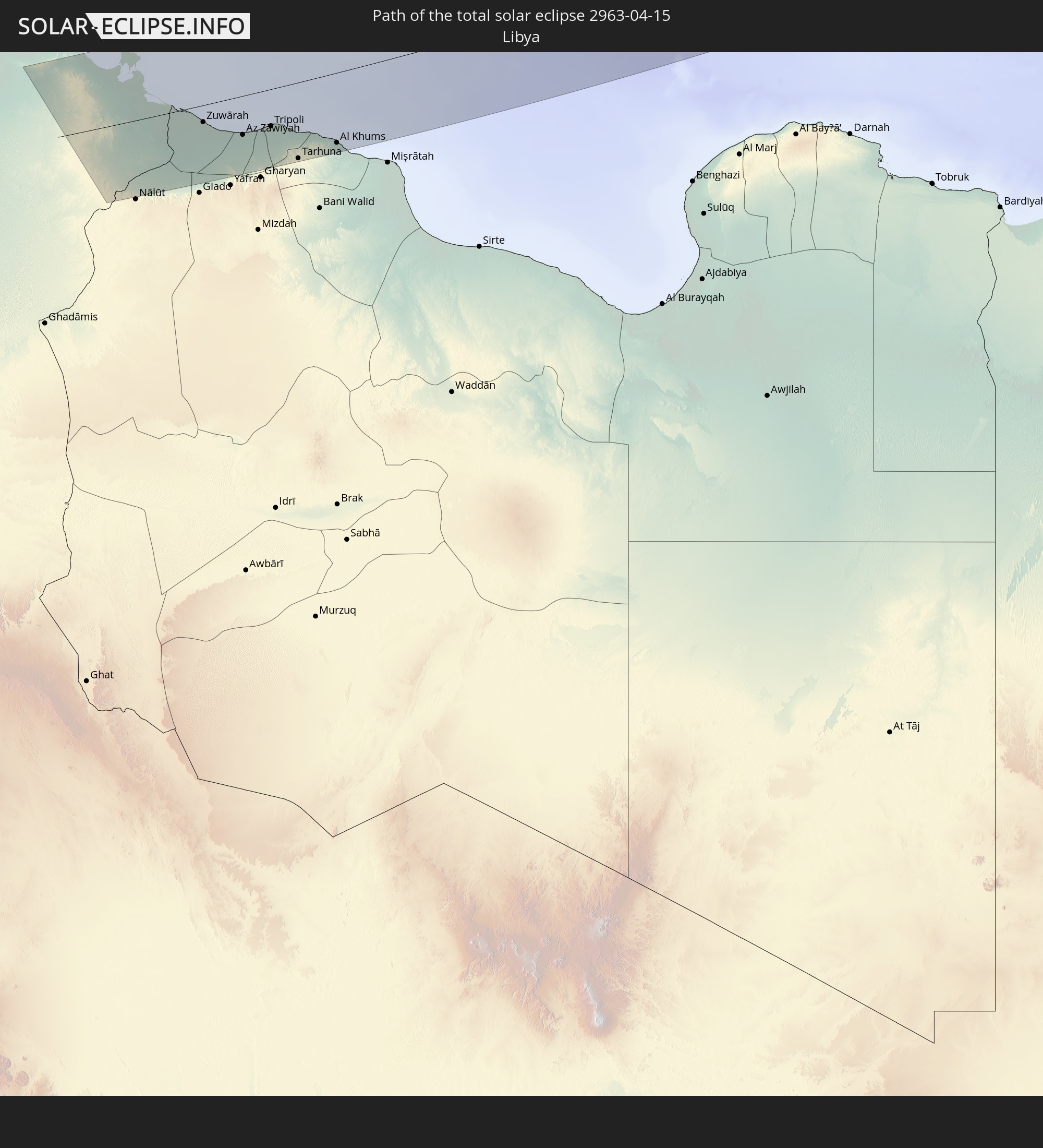 Libyen
 Griechenland
 Türkei
 Georgien
 Kasachstan
In den folgenden Ländern ist die Sonnenfinsternis partiell zu sehen
 Russland
 Kanada
 Grönland
 Island
 Irland
 Spitzbergen
 Algerien
 Vereinigtes Königreich
 Färöer
 Frankreich
 Isle of Man
 Guernsey
 Jersey
 Belgien
 Niederlande
 Norwegen
 Luxemburg
 Deutschland
 Schweiz
 Italien
 Monaco
 Tunesien
 Dänemark
 Libyen
 Liechtenstein
 Österreich
 Schweden
 Tschechien
 Demokratische Republik Kongo
 San Marino
 Vatikanstadt
 Slowenien
 Tschad
 Kroatien
 Polen
Polen
 Malta
Malta
 Zentralafrikanische Republik
 Bosnien und Herzegowina
 Ungarn
 Slowakei
 Montenegro
 Serbien
 Albanien
 Åland Islands
 Griechenland
 Rumänien
 Mazedonien
 Finnland
 Litauen
 Lettland
 Estland
 Sudan
Sudan
 Ukraine
 Bulgarien
 Weißrussland
 Ägypten
 Türkei
 Moldawien
 Ruanda
 Tansania
 Uganda
 Republik Zypern
 Äthiopien
 Kenia
Kenia
 Staat Palästina
 Israel
 Saudi-Arabien
 Jordanien
 Libanon
 Syrien
 Eritrea
 Irak
Irak
 Georgien
 Somalia
 Dschibuti
 Jemen
Jemen
 Armenien
 Iran
Iran
 Aserbaidschan
 Kasachstan
 Kuwait
 Bahrain
 Katar
Katar
 Vereinigte Arabische Emirate
 Oman
Oman
 Turkmenistan
 Usbekistan
 Afghanistan
 Pakistan
 Tadschikistan
 Indien
 Kirgisistan
 Volksrepublik China
 Nepal
Nepal
 Mongolei
 Bangladesch
 Bhutan
 Myanmar
 Japan
Japan
 Nordkorea
 Südkorea
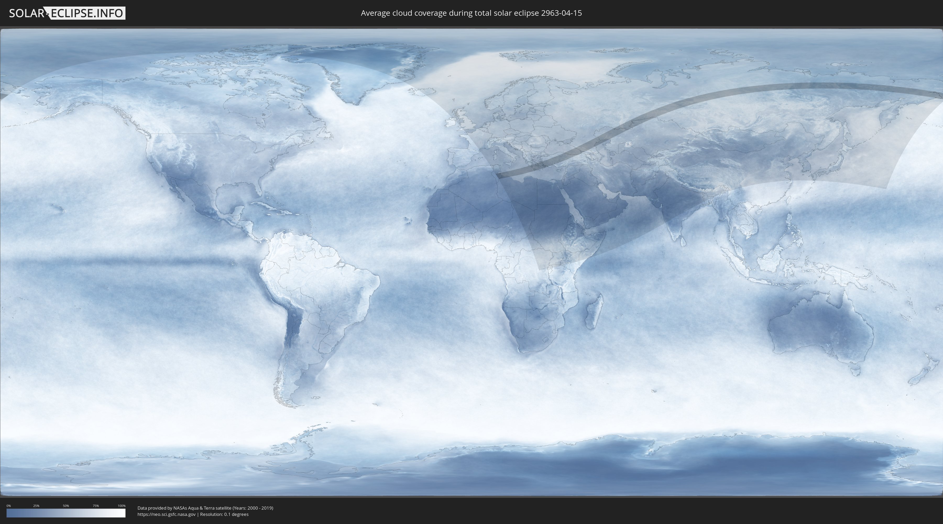
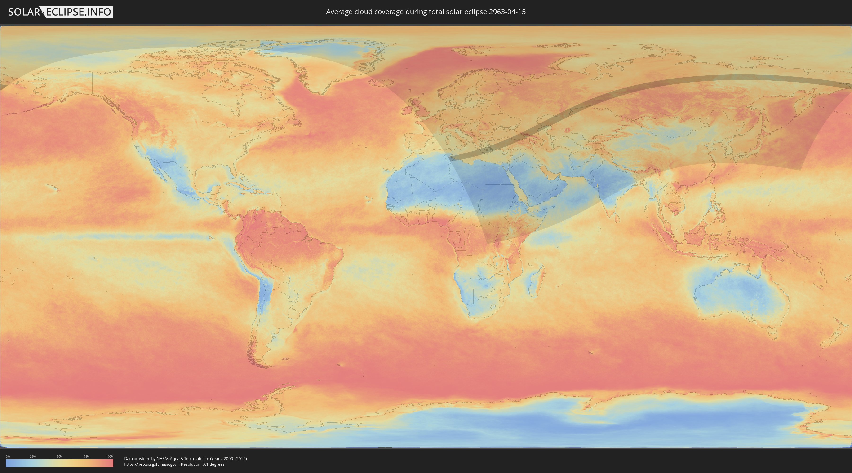
Wie wird das Wetter während der totalen Sonnenfinsternis am 15.04.2963?
Wo ist der beste Ort, um die totale Sonnenfinsternis vom 15.04.2963 zu beobachten?
Die folgenden Karten zeigen die durchschnittliche Bewölkung für den Tag, an dem die totale Sonnenfinsternis
stattfindet. Mit Hilfe der Karten lässt sich der Ort entlang des Finsternispfades eingrenzen,
der die besten Aussichen auf einen klaren wolkenfreien Himmel bietet.
Trotzdem muss man immer lokale Gegenenheiten beachten und sollte sich genau über das Wetter an seinem
gewählten Beobachtungsort informieren.
Die Daten stammen von den beiden NASA-Satelliten
AQUA und TERRA
und wurden über einen Zeitraum von 19 Jahren (2000 - 2019) gemittelt.
Detaillierte Länderkarten
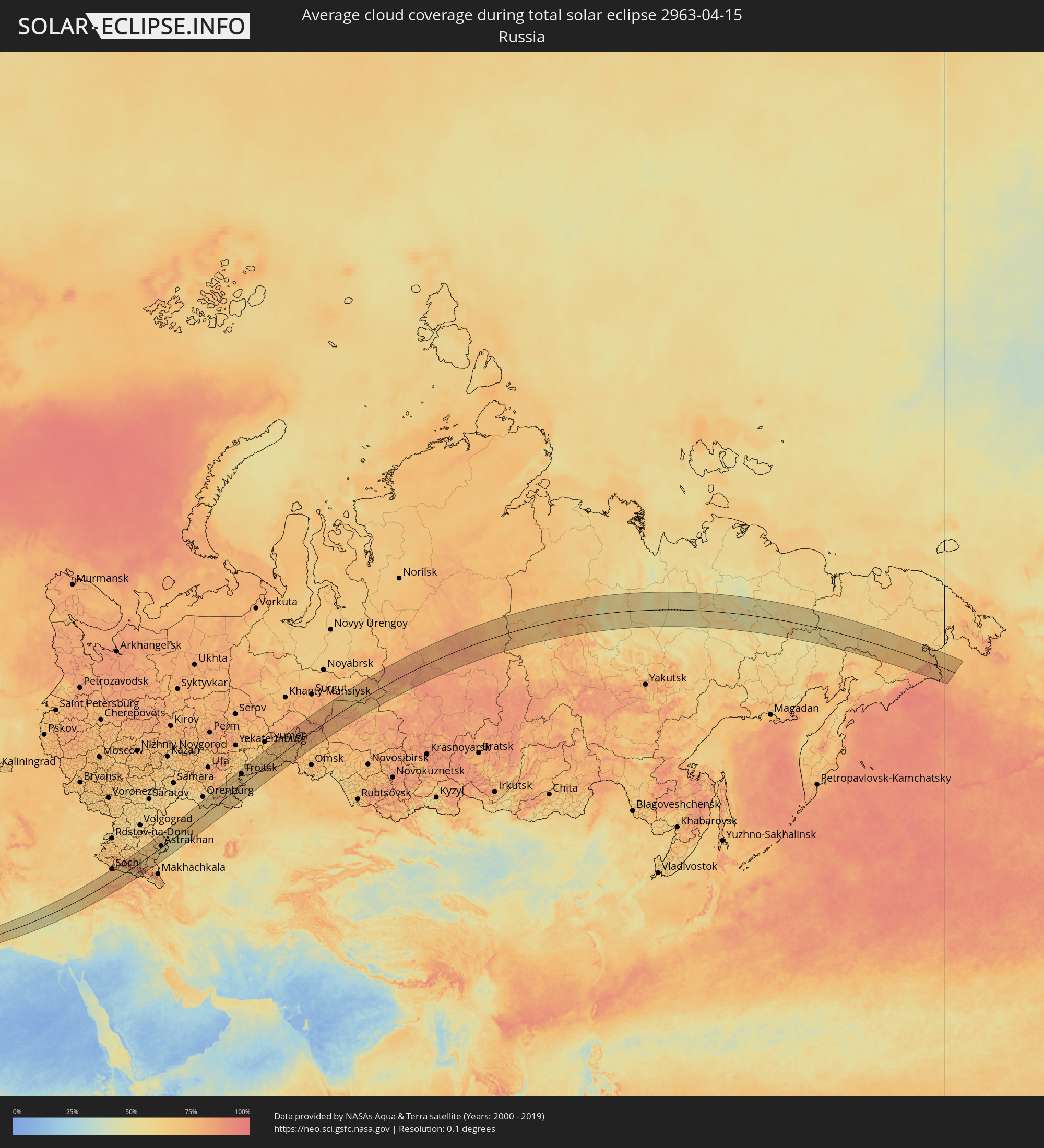 Russland
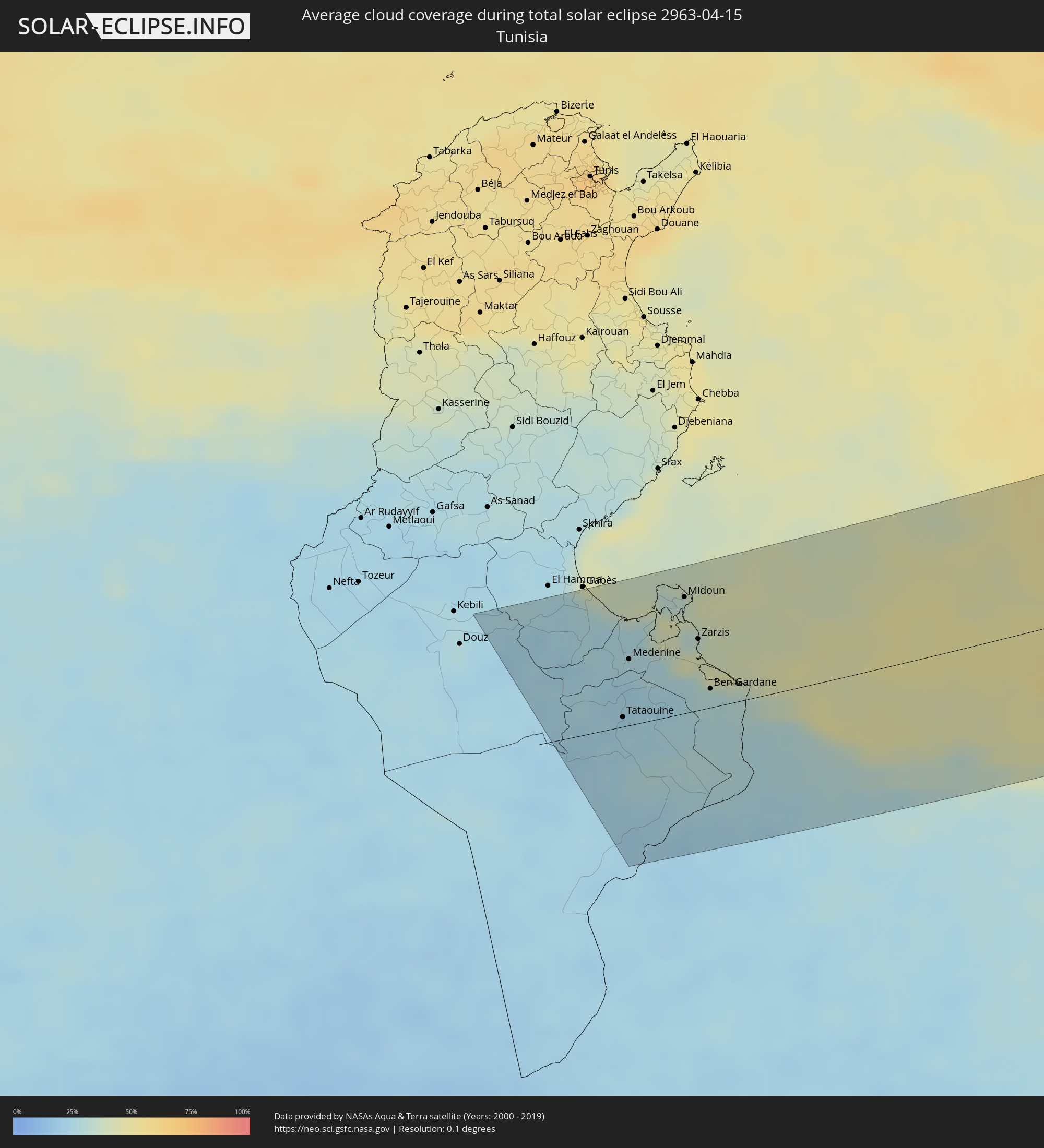 Tunesien
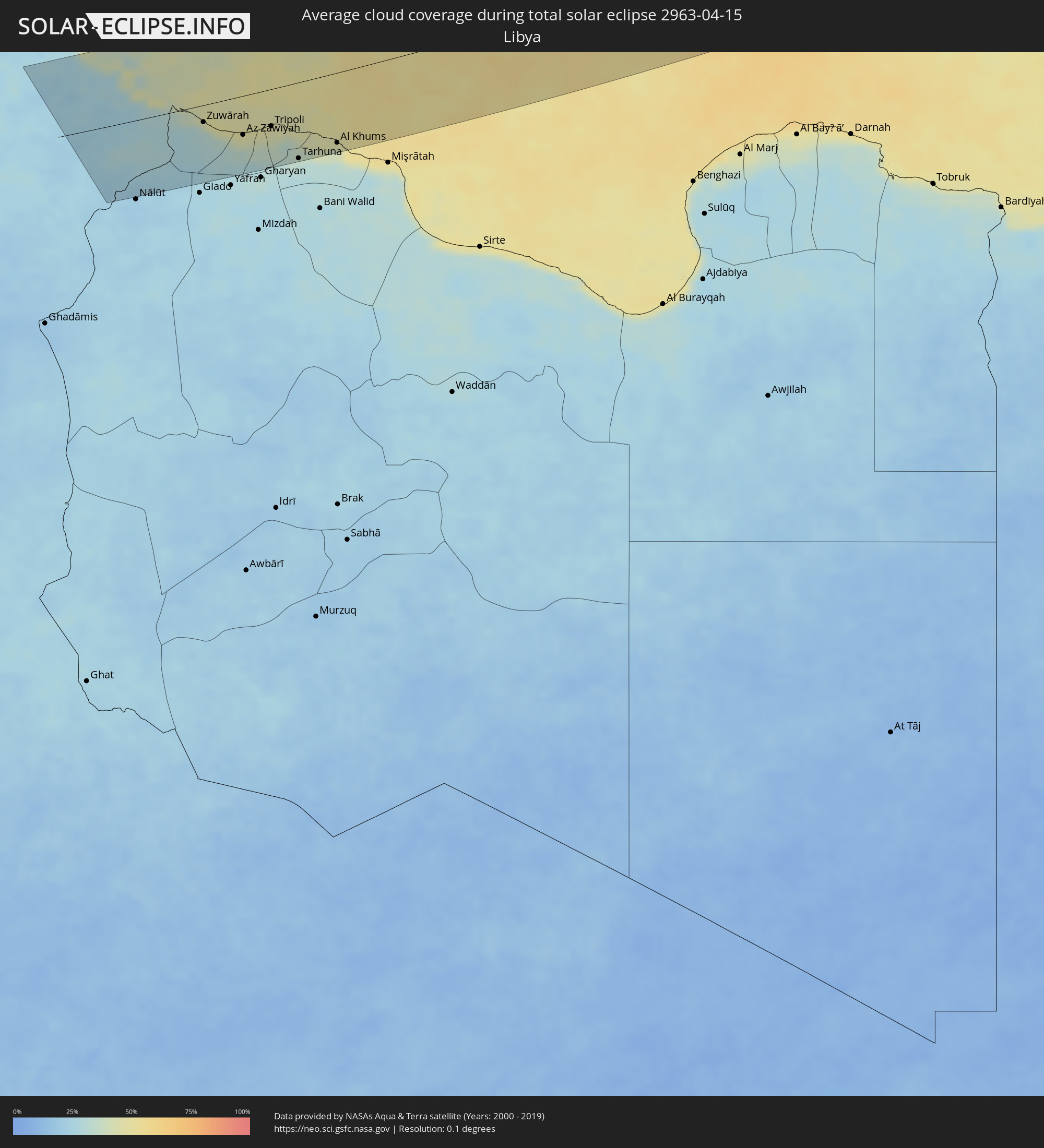 Libyen
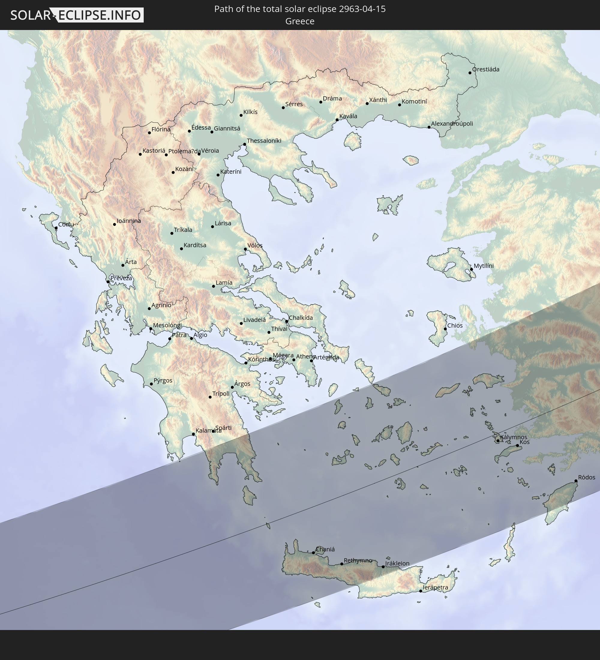
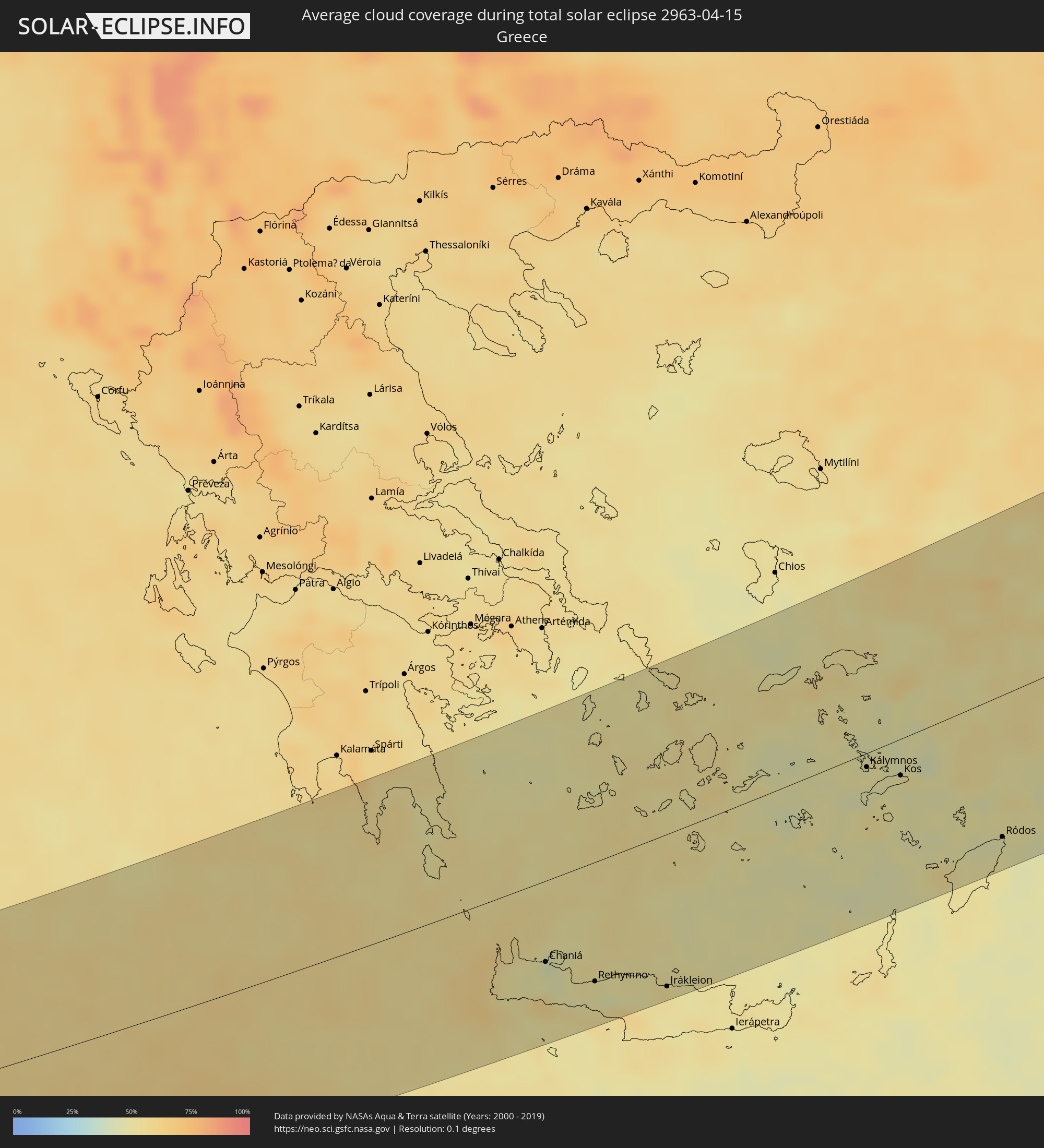 Griechenland
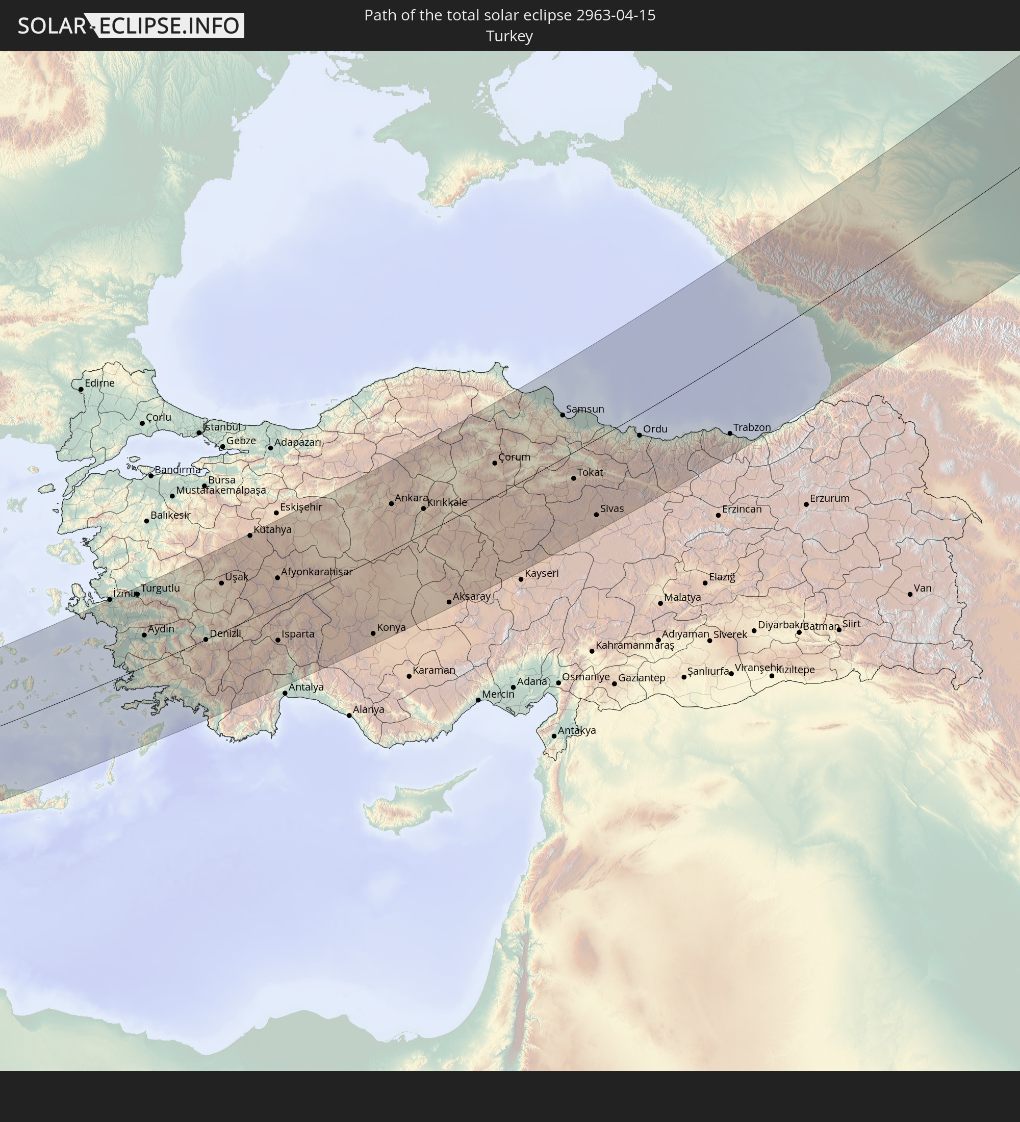
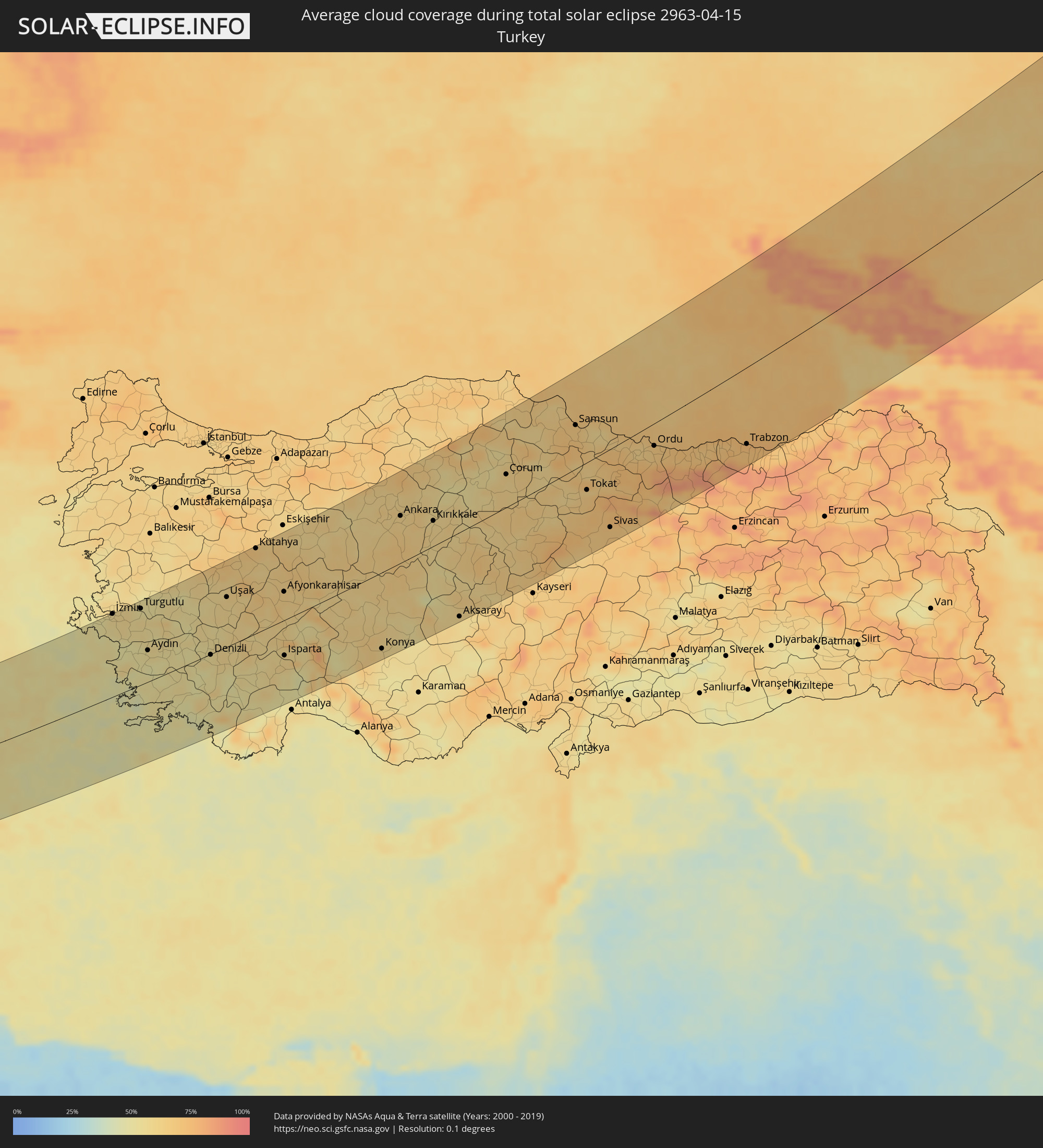 Türkei
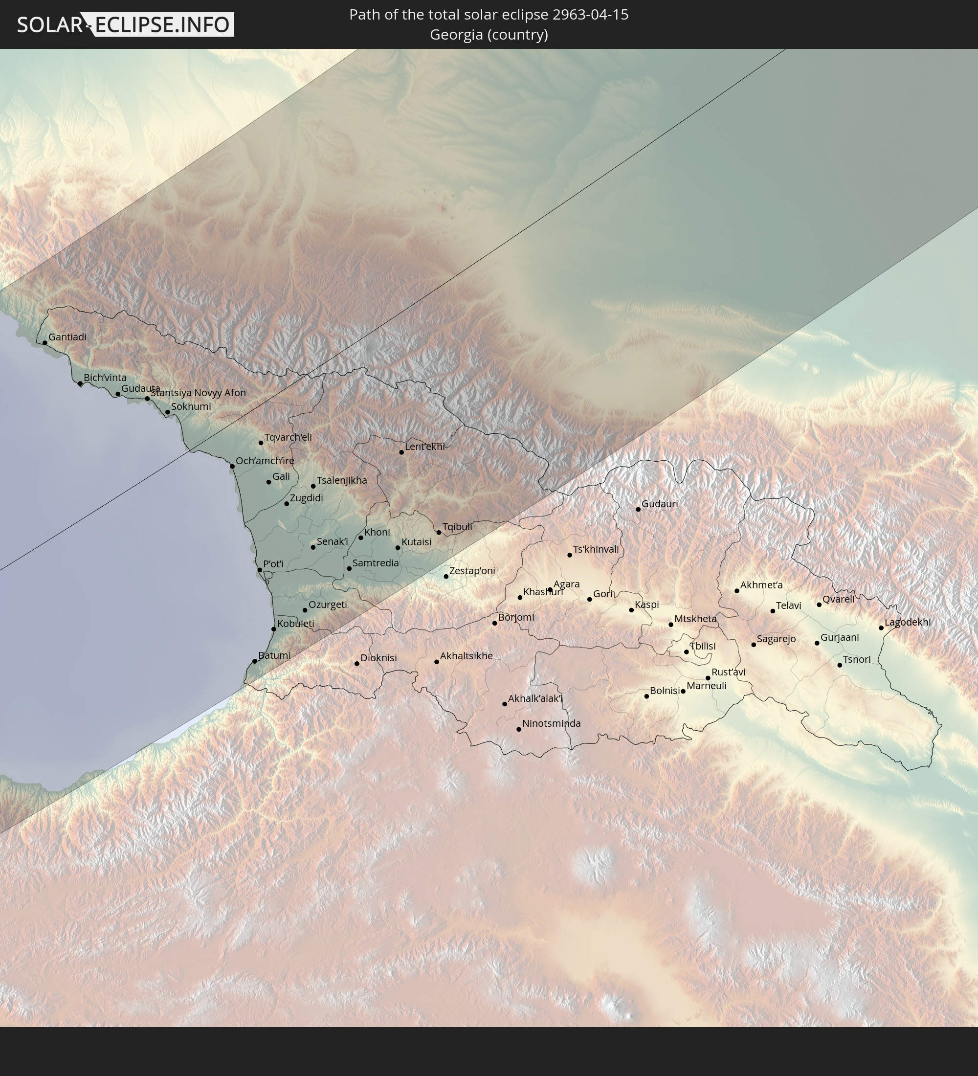
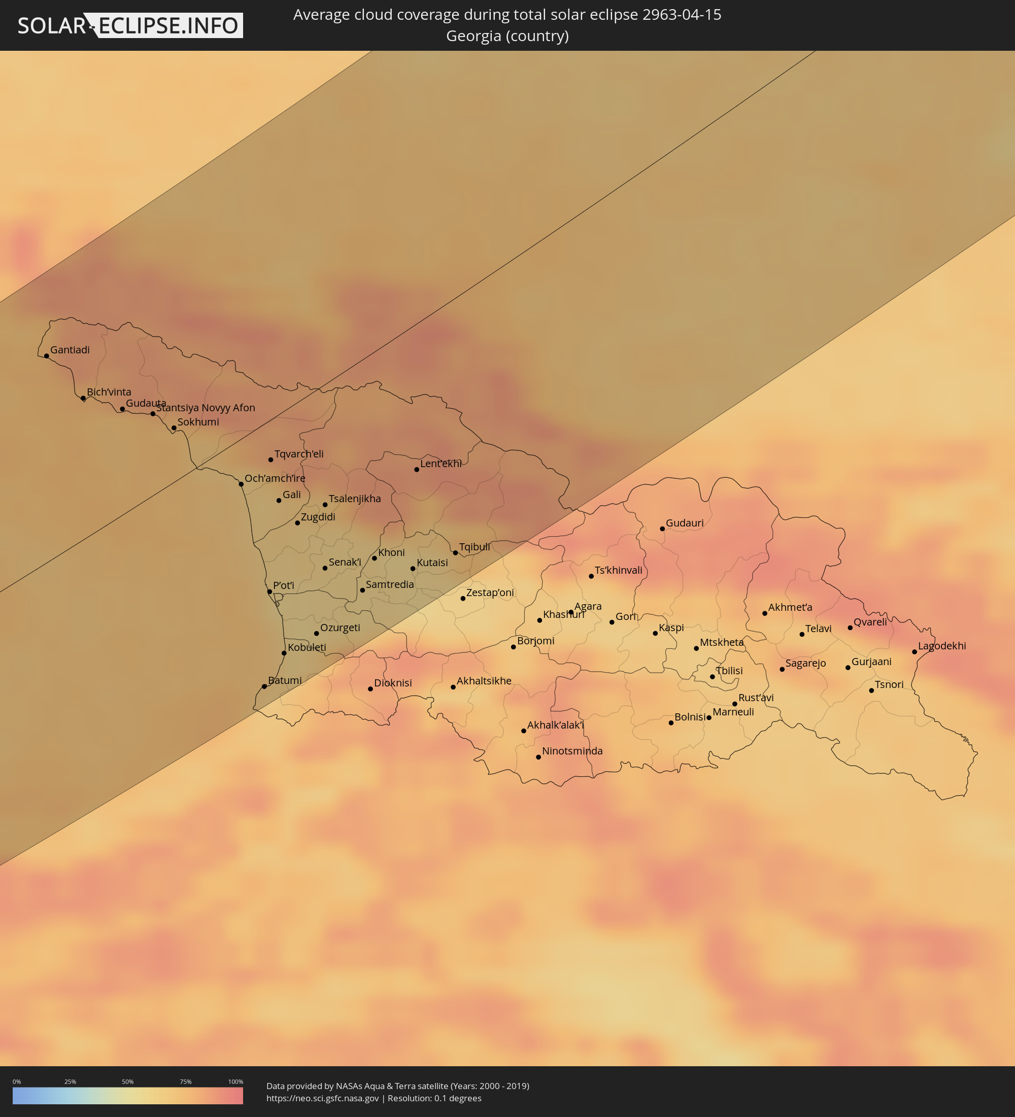 Georgien
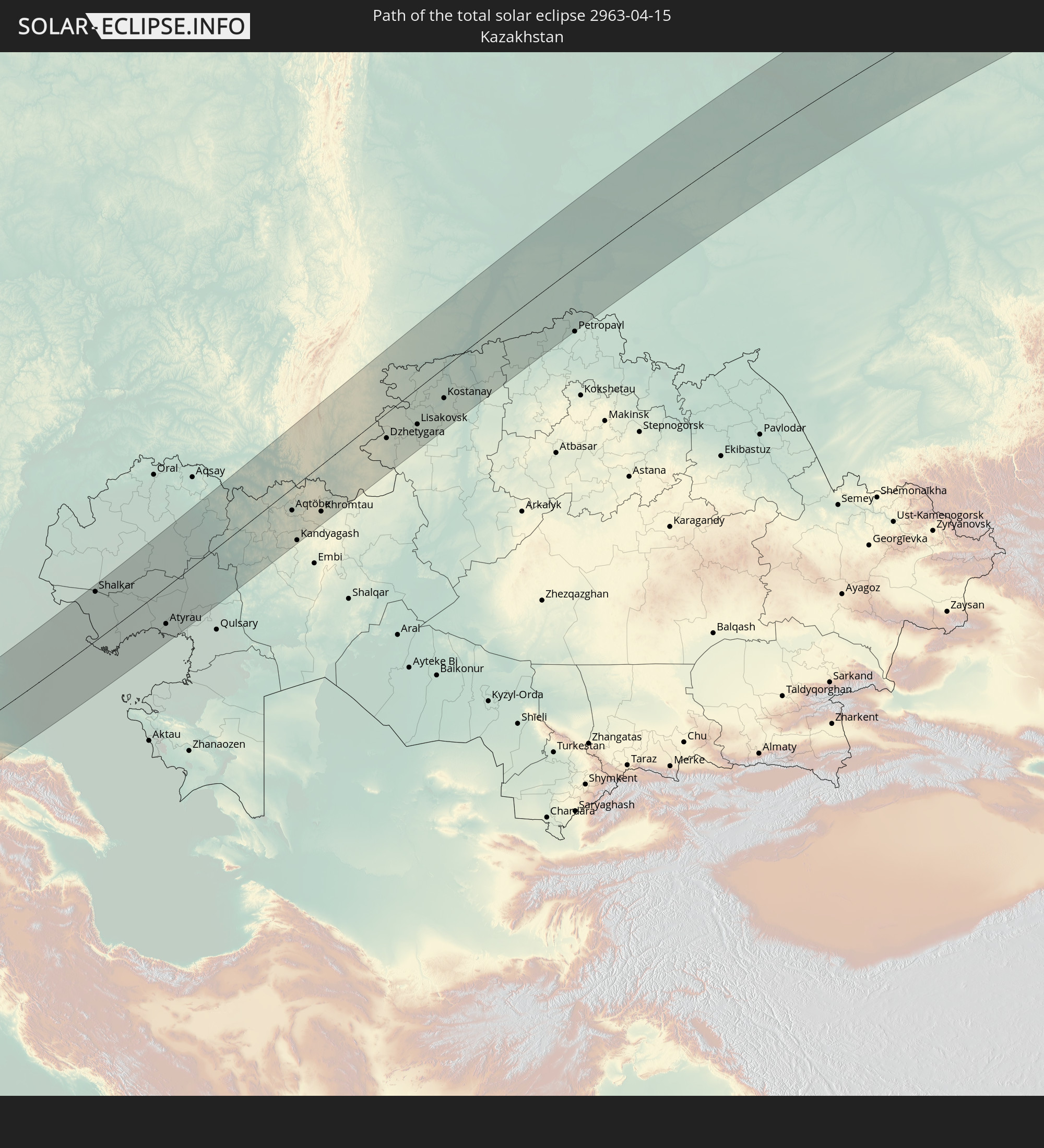
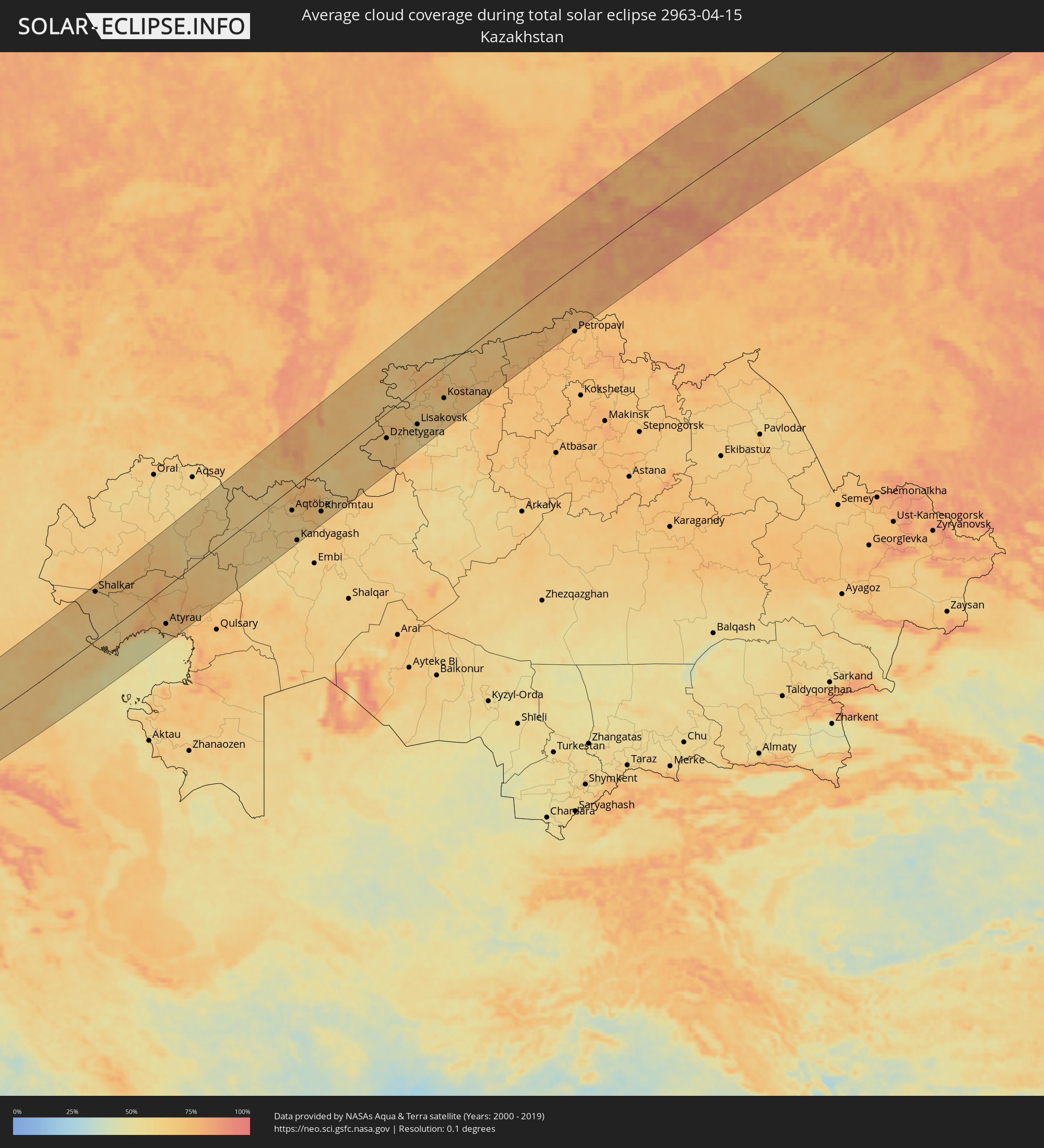 Kasachstan
Orte im Finsternispfad
Die nachfolgene Tabelle zeigt Städte und Orte mit mehr als 5.000 Einwohnern, die sich im Finsternispfad befinden. Städte mit mehr als 100.000 Einwohnern sind dick gekennzeichnet. Mit einem Klick auf den Ort öffnet sich eine Detailkarte die die Lage des jeweiligen Ortes zusammen mit dem Verlauf der zentralen Finsternis präsentiert.
| Ort | Typ | Dauer der Verfinsterung | Ortszeit bei maximaler Verfinsterung | Entfernung zur Zentrallinie | Ø Bewölkung |
|
Tataouine, Tataouine
|
total | - | 05:56:05 UTC+01:00 | 8 km | 25% |
|
Medenine, Madanīn
|
total | - | 05:56:38 UTC+01:00 | 54 km | 26% |
|
Houmt Souk, Madanīn
|
total | - | 05:57:16 UTC+01:00 | 103 km | 33% |
|
Midoun, Madanīn
|
total | - | 05:57:09 UTC+01:00 | 95 km | 37% |
|
Zarzis, Madanīn
|
total | - | 05:56:43 UTC+01:00 | 62 km | 41% |
|
Ben Gardane, Madanīn
|
total | - | 05:56:12 UTC+01:00 | 28 km | 29% |
|
Zalţan, An Nuqāţ al Khams
|
total | - | 06:55:50 UTC+02:00 | 25 km | 28% |
|
Zuwārah, An Nuqāţ al Khams
|
total | - | 06:55:46 UTC+02:00 | 25 km | 31% |
|
Şabrātah, Az Zāwiyah
|
total | - | 06:55:31 UTC+02:00 | 50 km | 40% |
|
Şurmān, Az Zāwiyah
|
total | - | 06:55:27 UTC+02:00 | 55 km | 44% |
|
Az Zāwīyah, Az Zāwiyah
|
total | - | 06:55:26 UTC+02:00 | 58 km | 45% |
|
Zawiya, Az Zāwiyah
|
total | - | 06:55:26 UTC+02:00 | 59 km | 45% |
|
Al ‘Azīzīyah, Sha‘bīyat al Jafārah
|
total | - | 06:55:05 UTC+02:00 | 90 km | 30% |
|
Tripoli, Tripoli
|
total | - | 06:55:31 UTC+02:00 | 55 km | 43% |
|
Tagiura, Tripoli
|
total | - | 06:55:30 UTC+02:00 | 61 km | 43% |
|
Tarhuna, Al Marqab
|
total | - | 06:54:52 UTC+02:00 | 113 km | 30% |
|
Masallātah, Al Marqab
|
total | - | 06:55:03 UTC+02:00 | 103 km | 41% |
|
Al Khums, Al Marqab
|
total | - | 06:55:04 UTC+02:00 | 103 km | 42% |
|
Mourniés, Crete
|
total | - | 06:59:05 UTC+02:00 | 70 km | 48% |
|
Chaniá, Crete
|
total | - | 06:59:08 UTC+02:00 | 66 km | 48% |
|
Soúda, Crete
|
total | - | 06:59:06 UTC+02:00 | 69 km | 46% |
|
Rethymno, Crete
|
total | - | 06:58:58 UTC+02:00 | 93 km | 48% |
|
Ermoúpolis, South Aegean
|
total | - | 07:02:15 UTC+02:00 | 109 km | 51% |
|
Gázi, Crete
|
total | - | 06:59:00 UTC+02:00 | 116 km | 52% |
|
Irákleion, Crete
|
total | - | 06:59:00 UTC+02:00 | 119 km | 52% |
|
Páros, South Aegean
|
total | - | 07:01:43 UTC+02:00 | 65 km | 53% |
|
Néa Alikarnassós, Crete
|
total | - | 06:59:02 UTC+02:00 | 118 km | 51% |
|
Náxos, South Aegean
|
total | - | 07:01:48 UTC+02:00 | 60 km | 53% |
|
Néon Karlovásion, North Aegean
|
total | - | 07:03:09 UTC+02:00 | 85 km | 54% |
|
Kálymnos, South Aegean
|
total | - | 07:01:53 UTC+02:00 | 12 km | 49% |
|
İzmir, İzmir
|
total | - | 08:04:14 UTC+03:00 | 135 km | 57% |
|
Kos, South Aegean
|
total | - | 07:01:51 UTC+02:00 | 32 km | 47% |
|
Turgutlu, Manisa
|
total | - | 08:04:30 UTC+03:00 | 124 km | 54% |
|
Aydın, Aydın
|
total | - | 08:03:30 UTC+03:00 | 51 km | 50% |
|
Archángelos, South Aegean
|
total | - | 07:00:58 UTC+02:00 | 126 km | 50% |
|
Salihli, Manisa
|
total | - | 08:04:36 UTC+03:00 | 105 km | 55% |
|
Afántou, South Aegean
|
total | - | 07:01:06 UTC+02:00 | 120 km | 51% |
|
Triánta, South Aegean
|
total | - | 07:01:17 UTC+02:00 | 109 km | 49% |
|
Faliraki, South Aegean
|
total | - | 07:01:11 UTC+02:00 | 117 km | 51% |
|
Ródos, South Aegean
|
total | - | 07:01:21 UTC+02:00 | 109 km | 49% |
|
Nazilli, Aydın
|
total | - | 08:03:44 UTC+03:00 | 41 km | 53% |
|
Denizli, Denizli
|
total | - | 08:03:43 UTC+03:00 | 8 km | 55% |
|
Uşak, Uşak
|
total | - | 08:05:16 UTC+03:00 | 81 km | 60% |
|
Kütahya, Kütahya
|
total | - | 08:06:40 UTC+03:00 | 133 km | 66% |
|
Afyonkarahisar, Afyonkarahisar
|
total | - | 08:05:45 UTC+03:00 | 44 km | 63% |
|
Isparta, Isparta
|
total | - | 08:04:08 UTC+03:00 | 60 km | 60% |
|
Polatlı, Ankara
|
total | - | 08:07:40 UTC+03:00 | 65 km | 60% |
|
Konya, Konya
|
total | - | 08:04:59 UTC+03:00 | 119 km | 59% |
|
Ankara, Ankara
|
total | - | 08:08:31 UTC+03:00 | 75 km | 61% |
|
Kırıkkale, Kırıkkale
|
total | - | 08:08:40 UTC+03:00 | 43 km | 61% |
|
Aksaray, Aksaray
|
total | - | 08:06:25 UTC+03:00 | 129 km | 58% |
|
Kırşehir, Kırşehir
|
total | - | 08:07:46 UTC+03:00 | 59 km | 61% |
|
Yozgat, Yozgat
|
total | - | 08:09:11 UTC+03:00 | 26 km | 61% |
|
Çorum, Çorum
|
total | - | 08:10:29 UTC+03:00 | 54 km | 59% |
|
Amasya, Amasya
|
total | - | 08:11:05 UTC+03:00 | 23 km | 60% |
|
Bafra, Samsun
|
total | - | 08:12:41 UTC+03:00 | 108 km | 63% |
|
Turhal, Tokat
|
total | - | 08:10:45 UTC+03:00 | 13 km | 61% |
|
Samsun, Samsun
|
total | - | 08:12:25 UTC+03:00 | 66 km | 66% |
|
Tokat, Tokat
|
total | - | 08:10:52 UTC+03:00 | 44 km | 67% |
|
Sivas, Sivas
|
total | - | 08:10:08 UTC+03:00 | 115 km | 68% |
|
Ünye, Ordu
|
total | - | 08:12:38 UTC+03:00 | 18 km | 64% |
|
Fatsa, Ordu
|
total | - | 08:12:35 UTC+03:00 | 12 km | 62% |
|
Ordu, Ordu
|
total | - | 08:12:42 UTC+03:00 | 37 km | 67% |
|
Giresun, Giresun
|
total | - | 08:12:52 UTC+03:00 | 59 km | 69% |
|
Sochi, Krasnodarskiy
|
total | - | 08:18:18 UTC+03:00 | 138 km | 72% |
|
Trabzon, Trabzon
|
total | - | 08:13:48 UTC+03:00 | 108 km | 70% |
|
Adler, Krasnodarskiy
|
total | - | 08:18:08 UTC+03:00 | 114 km | 75% |
|
Gantiadi
|
total | - | 09:18:08 UTC+04:00 | 104 km | 76% |
|
Gagra, Abkhazia
|
total | - | 09:18:05 UTC+04:00 | 85 km | 76% |
|
Bich’vinta, Abkhazia
|
total | - | 09:17:55 UTC+04:00 | 72 km | 73% |
|
Gudauta, Abkhazia
|
total | - | 09:18:00 UTC+04:00 | 52 km | 71% |
|
Stantsiya Novyy Afon, Abkhazia
|
total | - | 09:18:05 UTC+04:00 | 41 km | 73% |
|
Sokhumi, Abkhazia
|
total | - | 09:18:03 UTC+04:00 | 31 km | 73% |
|
Och’amch’ire, Abkhazia
|
total | - | 09:17:51 UTC+04:00 | 29 km | 65% |
|
Batumi, Ajaria
|
total | - | 09:16:06 UTC+04:00 | 132 km | 66% |
|
P’ot’i, Samegrelo and Zemo Svaneti
|
total | - | 09:17:00 UTC+04:00 | 86 km | 64% |
|
Tqvarch'eli, Abkhazia
|
total | - | 09:18:13 UTC+04:00 | 20 km | 69% |
|
Chakvi, Ajaria
|
total | - | 09:16:18 UTC+04:00 | 127 km | 64% |
|
Gali, Abkhazia
|
total | - | 09:17:53 UTC+04:00 | 43 km | 65% |
|
Kobuleti, Ajaria
|
total | - | 09:16:30 UTC+04:00 | 120 km | 63% |
|
Zugdidi, Samegrelo and Zemo Svaneti
|
total | - | 09:17:46 UTC+04:00 | 60 km | 63% |
|
Khobi, Samegrelo and Zemo Svaneti
|
total | - | 09:17:27 UTC+04:00 | 80 km | 59% |
|
Nevinnomyssk, Stavropol'skiy
|
total | - | 08:21:32 UTC+03:00 | 135 km | 71% |
|
Ozurgeti, Guria
|
total | - | 09:16:50 UTC+04:00 | 122 km | 66% |
|
Cherkessk, Karachayevo-Cherkesiya
|
total | - | 08:20:53 UTC+03:00 | 94 km | 69% |
|
Senak’i, Samegrelo and Zemo Svaneti
|
total | - | 09:17:29 UTC+04:00 | 91 km | 61% |
|
Tsalenjikha, Samegrelo and Zemo Svaneti
|
total | - | 09:18:04 UTC+04:00 | 62 km | 63% |
|
Abasha, Samegrelo and Zemo Svaneti
|
total | - | 09:17:28 UTC+04:00 | 103 km | 61% |
|
Samtredia, Imereti
|
total | - | 09:17:27 UTC+04:00 | 114 km | 60% |
|
Mart’vili, Samegrelo and Zemo Svaneti
|
total | - | 09:17:56 UTC+04:00 | 93 km | 61% |
|
Khoni, Imereti
|
total | - | 09:17:48 UTC+04:00 | 104 km | 61% |
|
Tsqaltubo, Imereti
|
total | - | 09:17:58 UTC+04:00 | 108 km | 59% |
|
Kutaisi, Imereti
|
total | - | 09:17:54 UTC+04:00 | 119 km | 59% |
|
Kislovodsk, Stavropol'skiy
|
total | - | 08:20:48 UTC+03:00 | 34 km | 75% |
|
Lent’ekhi, Racha-Lechkhumi and Kvemo Svaneti
|
total | - | 09:18:50 UTC+04:00 | 75 km | 83% |
|
Yessentuki, Stavropol'skiy
|
total | - | 08:21:07 UTC+03:00 | 41 km | 73% |
|
Tqibuli
|
total | - | 09:18:15 UTC+04:00 | 125 km | 70% |
|
Pyatigorsk, Stavropol'skiy
|
total | - | 08:21:16 UTC+03:00 | 38 km | 73% |
|
Mineralnye Vody, Stavropol'skiy
|
total | - | 08:21:36 UTC+03:00 | 43 km | 71% |
|
Georgiyevsk, Stavropol'skiy
|
total | - | 08:21:44 UTC+03:00 | 25 km | 71% |
|
Nal’chik, Kabardino-Balkariya
|
total | - | 08:20:42 UTC+03:00 | 49 km | 71% |
|
Zelenokumsk, Stavropol'skiy
|
total | - | 08:22:29 UTC+03:00 | 28 km | 68% |
|
Prokhladnyy, Kabardino-Balkariya
|
total | - | 08:21:27 UTC+03:00 | 46 km | 69% |
|
Budënnovsk, Stavropol'skiy
|
total | - | 08:23:21 UTC+03:00 | 48 km | 64% |
|
Staryy Malgobek, Ingushetiya
|
total | - | 08:21:29 UTC+03:00 | 85 km | 68% |
|
Mozdok, North Ossetia
|
total | - | 08:21:53 UTC+03:00 | 71 km | 65% |
|
Vladikavkaz, North Ossetia
|
total | - | 08:20:39 UTC+03:00 | 137 km | 75% |
|
Nazran’, Ingushetiya
|
total | - | 08:21:04 UTC+03:00 | 123 km | 66% |
|
Ordzhonikidzevskaya, Ingushetiya
|
total | - | 08:21:26 UTC+03:00 | 127 km | 66% |
|
Astrakhan, Astrakhan
|
total | - | 09:29:07 UTC+04:00 | 14 km | 64% |
|
Shalkar, Atyraū
|
total | - | 10:32:45 UTC+05:00 | 124 km | 69% |
|
Maloye Ganyushkino, Atyraū
|
total | - | 10:30:35 UTC+05:00 | 23 km | 64% |
|
Makhambet, Atyraū
|
total | - | 10:34:29 UTC+05:00 | 34 km | 74% |
|
Īnderbor, Atyraū
|
total | - | 10:36:10 UTC+05:00 | 38 km | 72% |
|
Balyqshy, Atyraū
|
total | - | 10:33:43 UTC+05:00 | 97 km | 69% |
|
Atyrau, Atyraū
|
total | - | 10:33:49 UTC+05:00 | 94 km | 69% |
|
Dossor, Atyraū
|
total | - | 10:35:33 UTC+05:00 | 106 km | 71% |
|
Maqat, Atyraū
|
total | - | 10:36:04 UTC+05:00 | 111 km | 71% |
|
Miyaly, Atyraū
|
total | - | 10:38:36 UTC+05:00 | 23 km | 66% |
|
Bayganin, Aqtöbe
|
total | - | 10:40:20 UTC+05:00 | 135 km | 58% |
|
Shubarkuduk, Aqtöbe
|
total | - | 10:41:42 UTC+05:00 | 120 km | 60% |
|
Martuk, Aqtöbe
|
total | - | 10:44:19 UTC+05:00 | 25 km | 61% |
|
Aqtöbe, Aqtöbe
|
total | - | 10:44:16 UTC+05:00 | 57 km | 64% |
|
Kandyagash, Aqtöbe
|
total | - | 10:43:11 UTC+05:00 | 135 km | 62% |
|
Batamshinskiy, Aqtöbe
|
total | - | 10:45:49 UTC+05:00 | 75 km | 73% |
|
Novotroitsk, Orenburg
|
total | - | 10:46:53 UTC+05:00 | 24 km | 63% |
|
Khromtau, Aqtöbe
|
total | - | 10:45:30 UTC+05:00 | 109 km | 68% |
|
Gay, Orenburg
|
total | - | 10:47:26 UTC+05:00 | 7 km | 66% |
|
Orsk, Orenburg
|
total | - | 10:47:08 UTC+05:00 | 36 km | 60% |
|
Sibay, Bashkortostan
|
total | - | 10:49:34 UTC+05:00 | 96 km | 71% |
|
Magnitogorsk, Chelyabinsk
|
total | - | 10:51:01 UTC+05:00 | 140 km | 70% |
|
Dzhetygara, Qostanay
|
total | - | 10:51:25 UTC+05:00 | 57 km | 66% |
|
Yuzhnoural’sk, Chelyabinsk
|
total | - | 10:54:46 UTC+05:00 | 136 km | 65% |
|
Troitsk, Chelyabinsk
|
total | - | 10:54:36 UTC+05:00 | 93 km | 63% |
|
Komsomolets, Qostanay
|
total | - | 10:54:36 UTC+05:00 | 43 km | 66% |
|
Lisakovsk, Qostanay
|
total | - | 10:53:21 UTC+05:00 | 83 km | 63% |
|
Tobol, Qostanay
|
total | - | 10:53:39 UTC+05:00 | 70 km | 65% |
|
Fedorovka, Qostanay
|
total | - | 10:55:07 UTC+05:00 | 21 km | 71% |
|
Kachar, Qostanay
|
total | - | 10:54:55 UTC+05:00 | 23 km | 63% |
|
Rudnyy, Qostanay
|
total | - | 10:54:38 UTC+05:00 | 68 km | 64% |
|
Kostanay, Qostanay
|
total | - | 10:55:32 UTC+05:00 | 68 km | 63% |
|
Borovskoy, Qostanay
|
total | - | 10:56:57 UTC+05:00 | 42 km | 67% |
|
Kurgan, Kurgan
|
total | - | 11:00:24 UTC+05:00 | 61 km | 68% |
|
Ishim, Tyumenskaya
|
total | - | 11:05:45 UTC+05:00 | 40 km | 77% |
|
Strezhevoy, Tomsk
|
total | - | 13:18:50 UTC+07:00 | 110 km | 69% |