Total solar eclipse of 08/08/-0151
| Day of week: | Monday |
| Maximum duration of eclipse: | 01m43s |
| Maximum width of eclipse path: | 87 km |
| Saros cycle: | 62 |
| Coverage: | 100% |
| Magnitude: | 1.0218 |
| Gamma: | 0.5222 |
Wo kann man die Sonnenfinsternis vom 08/08/-0151 sehen?
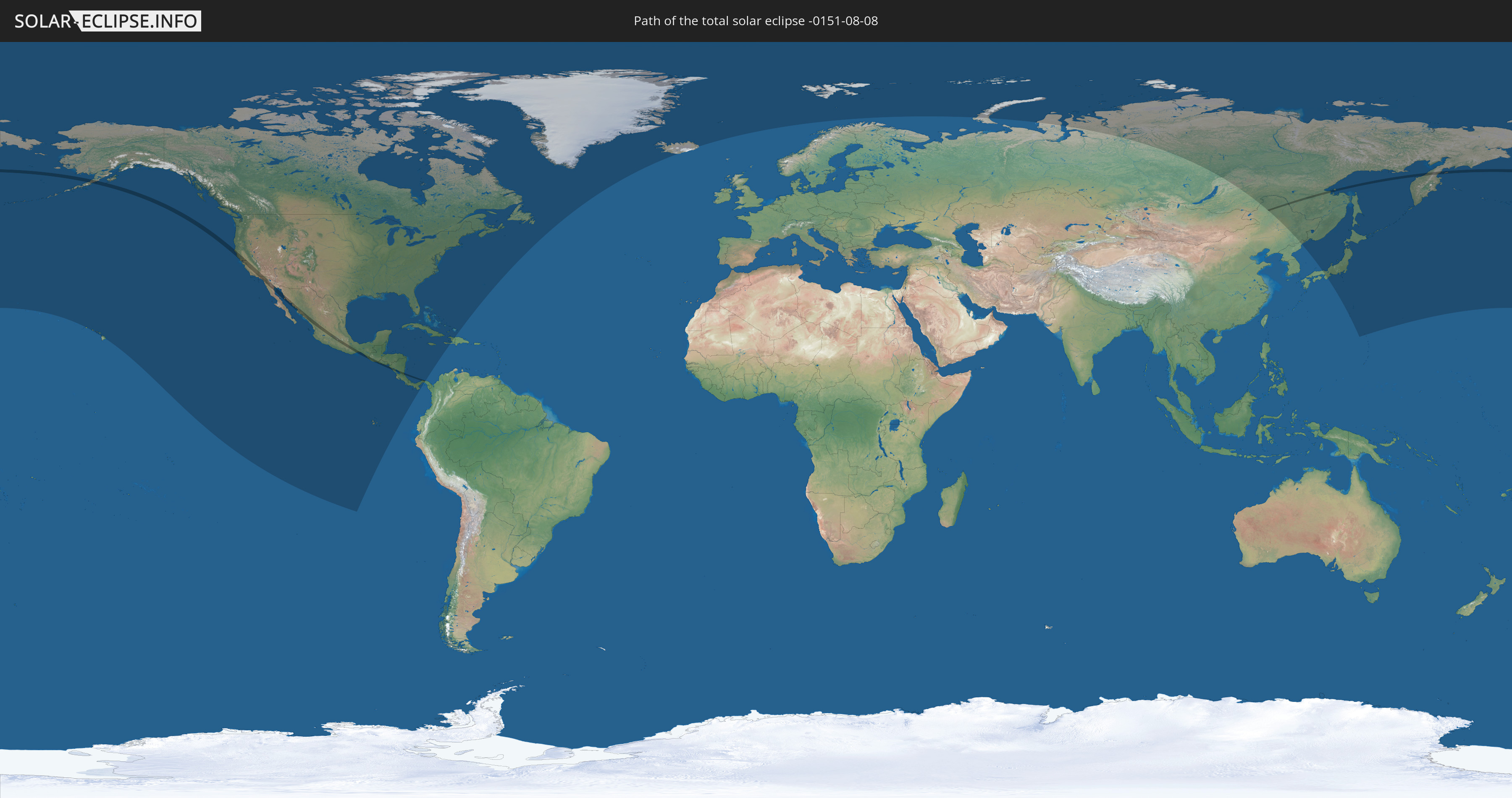
Die Sonnenfinsternis am 08/08/-0151 kann man in 30 Ländern als partielle Sonnenfinsternis beobachten.
Der Finsternispfad verläuft durch 9 Länder. Nur in diesen Ländern ist sie als total Sonnenfinsternis zu sehen.
In den folgenden Ländern ist die Sonnenfinsternis total zu sehen
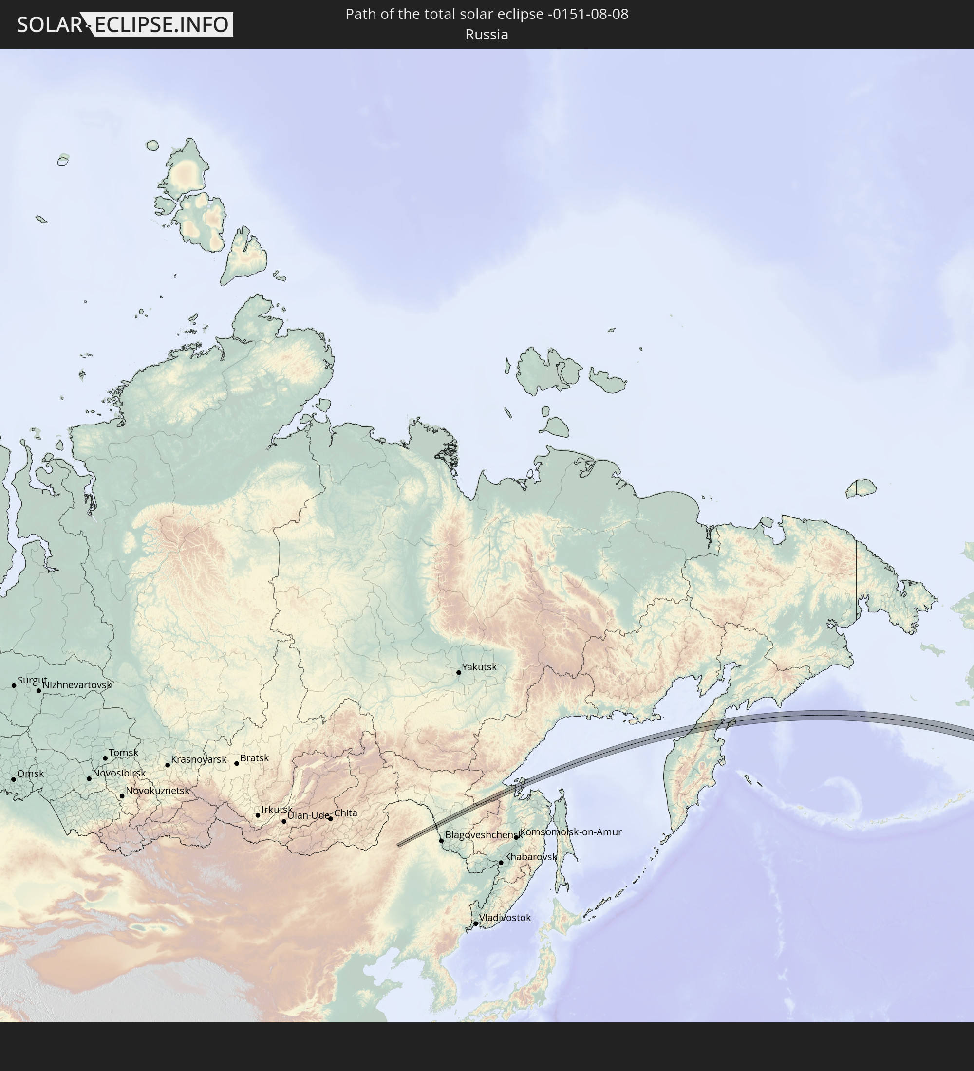 Russia
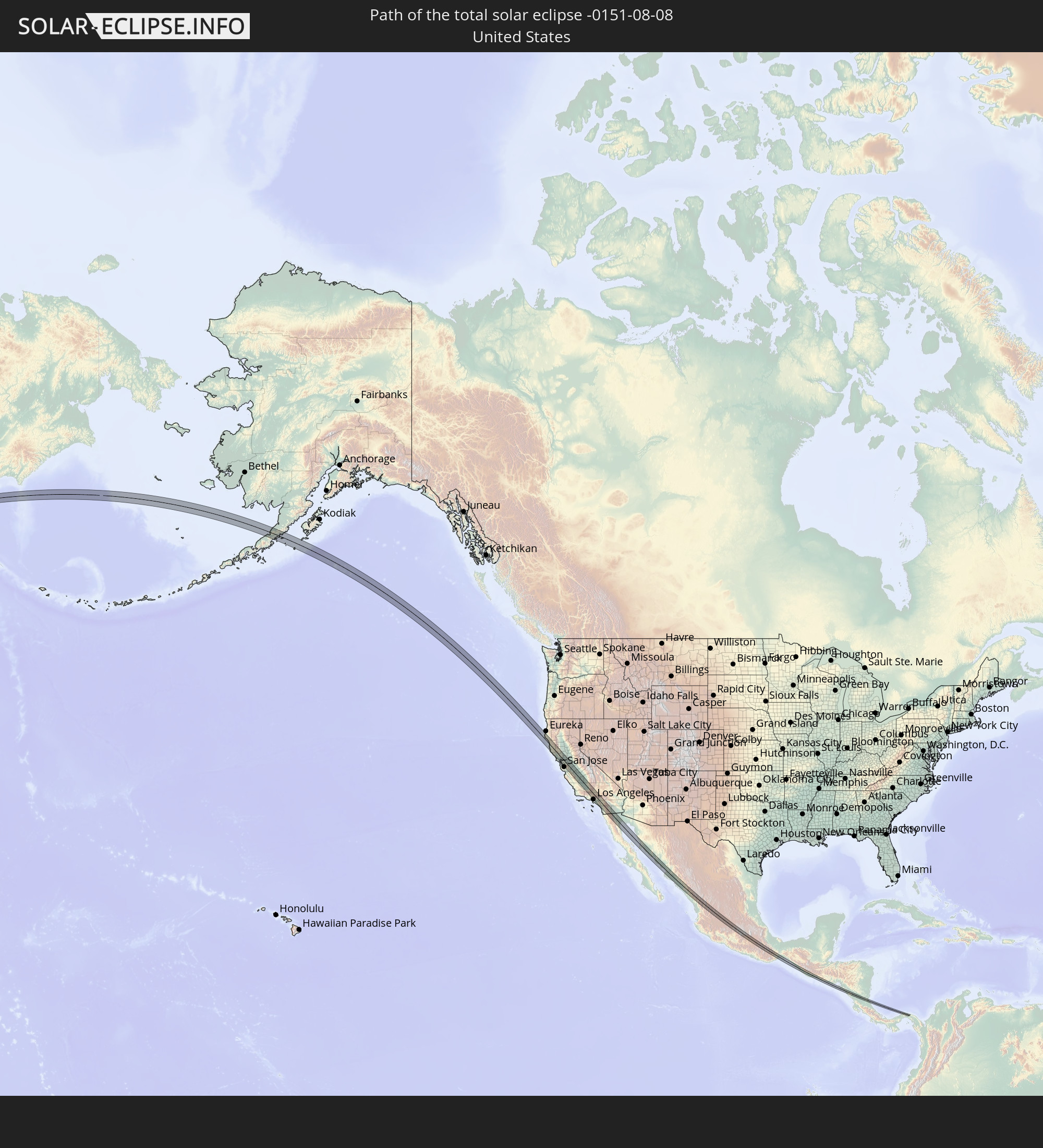 United States
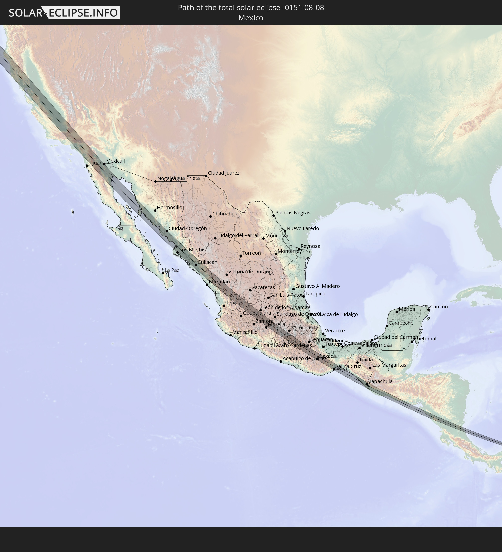 Mexico
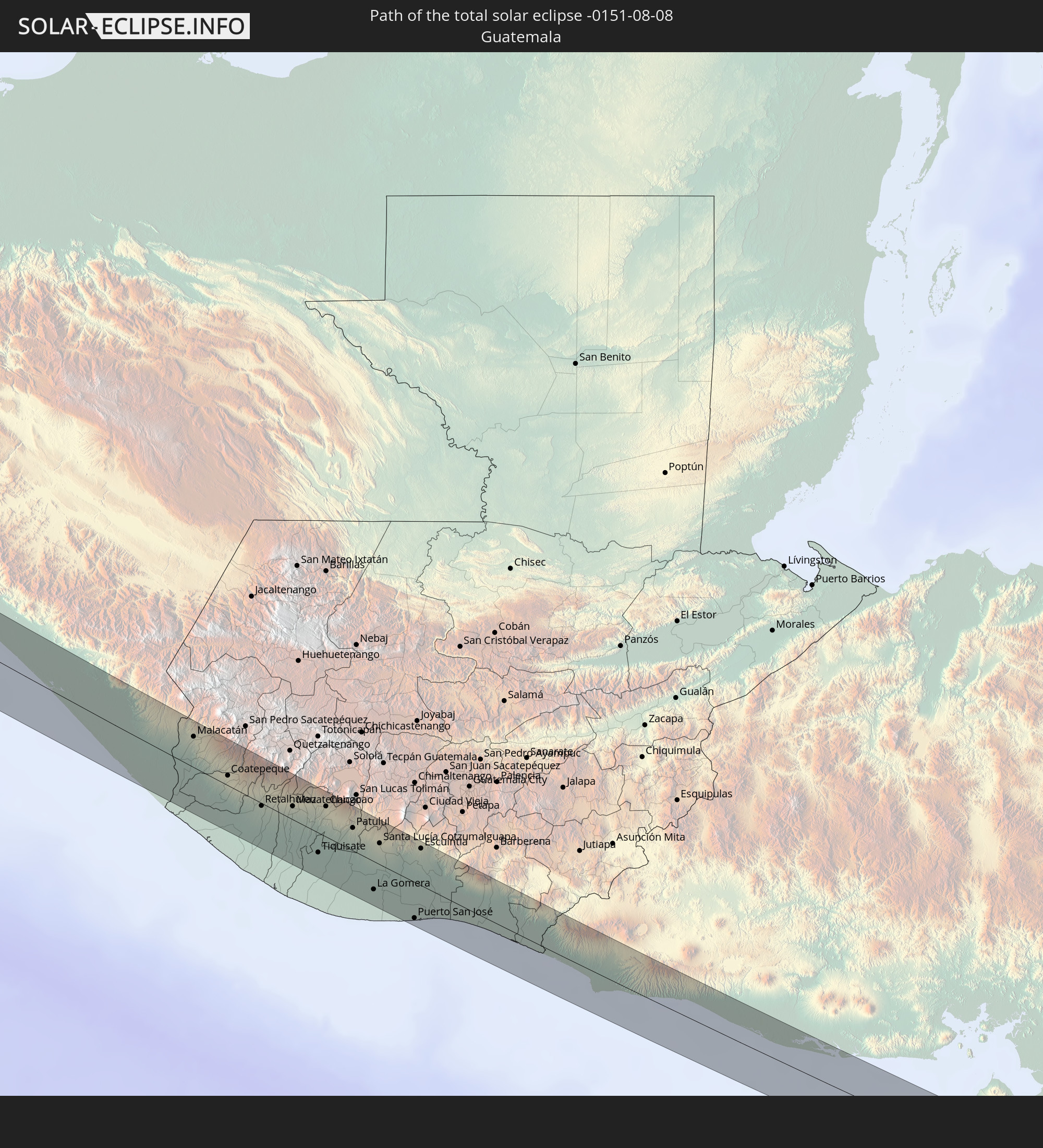 Guatemala
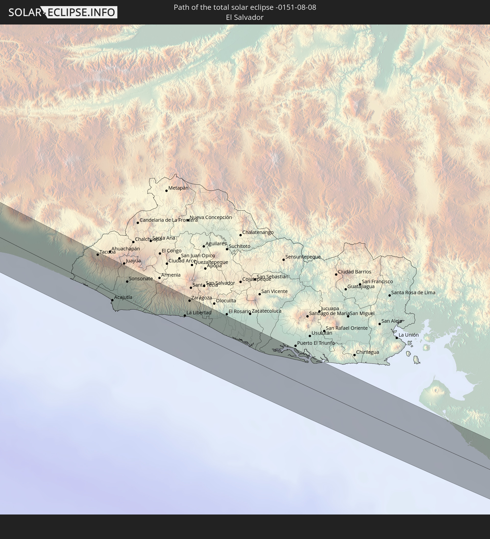 El Salvador
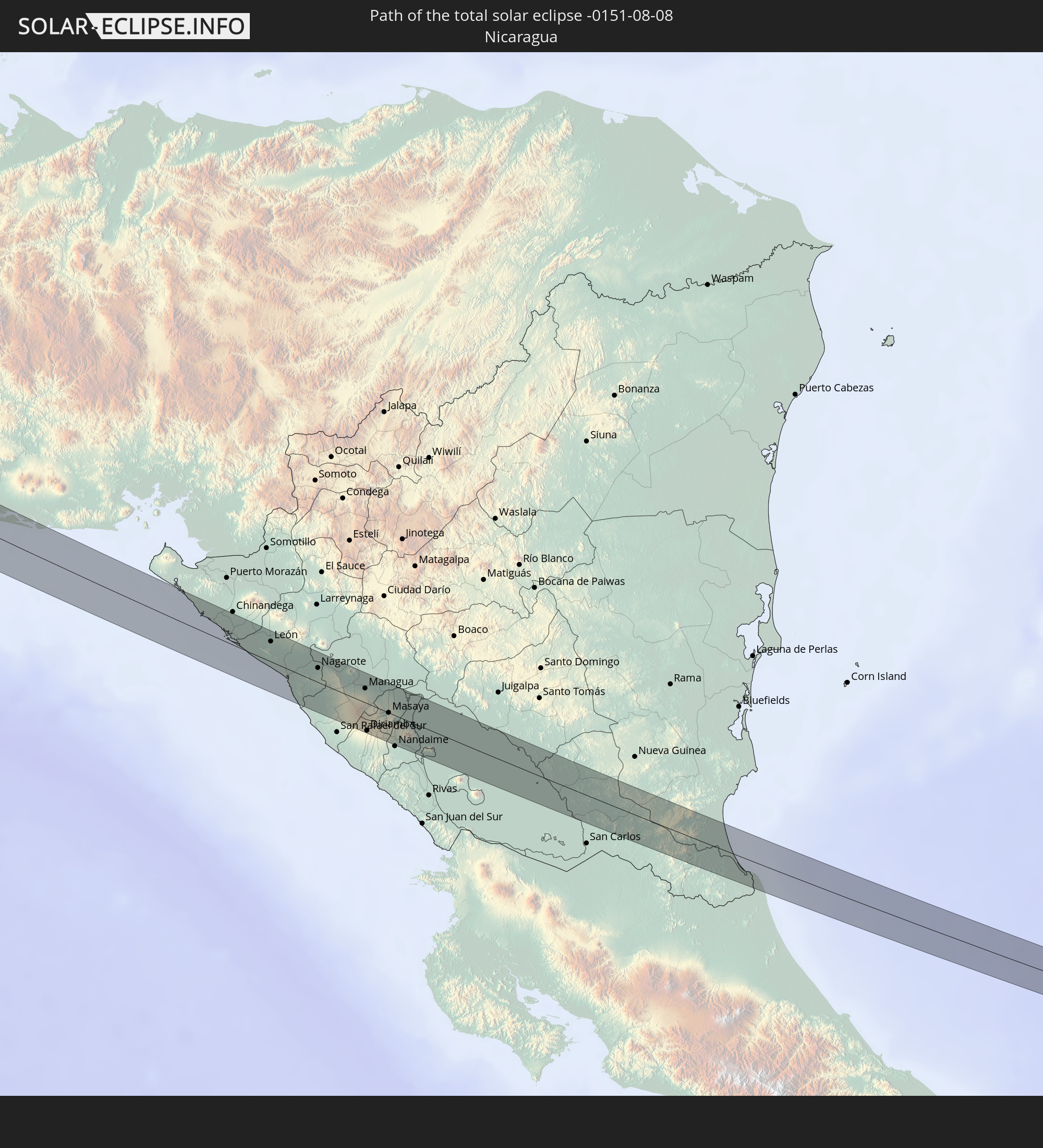 Nicaragua
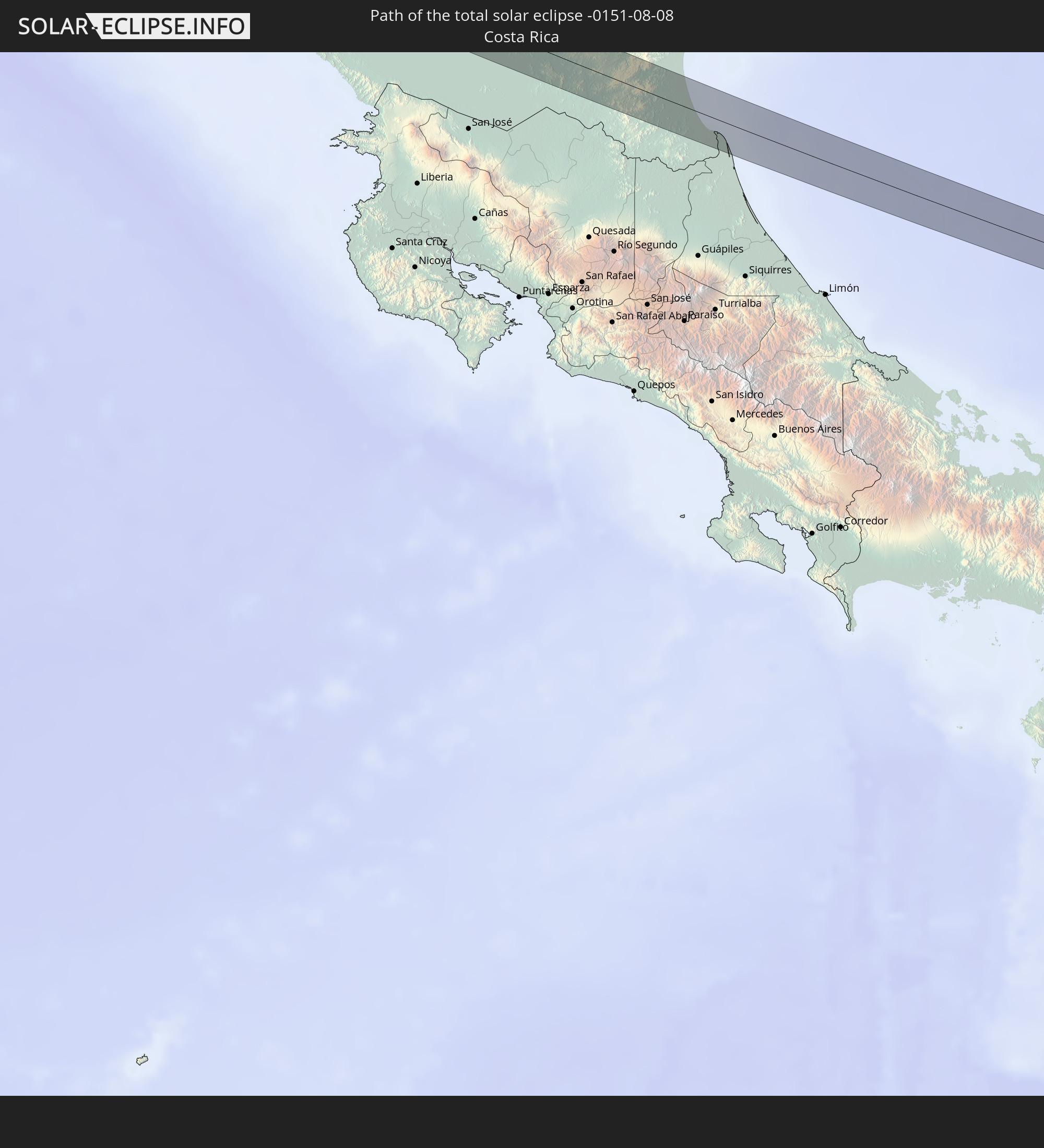 Costa Rica
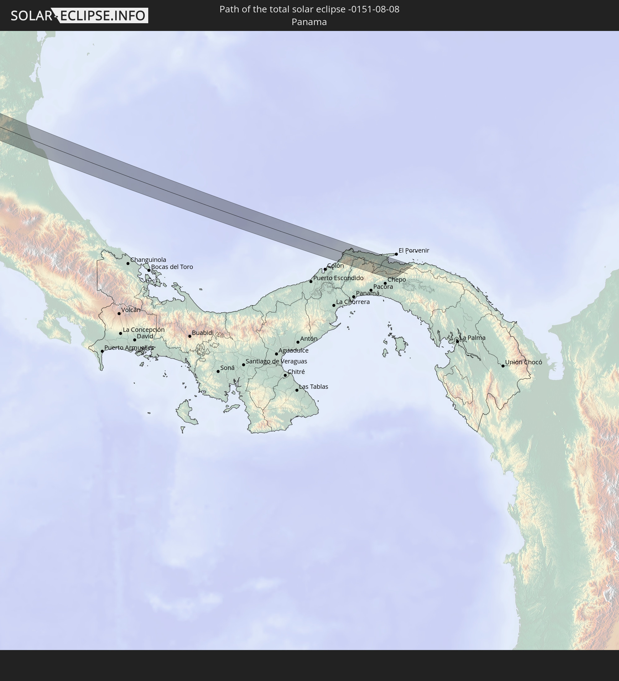 Panama
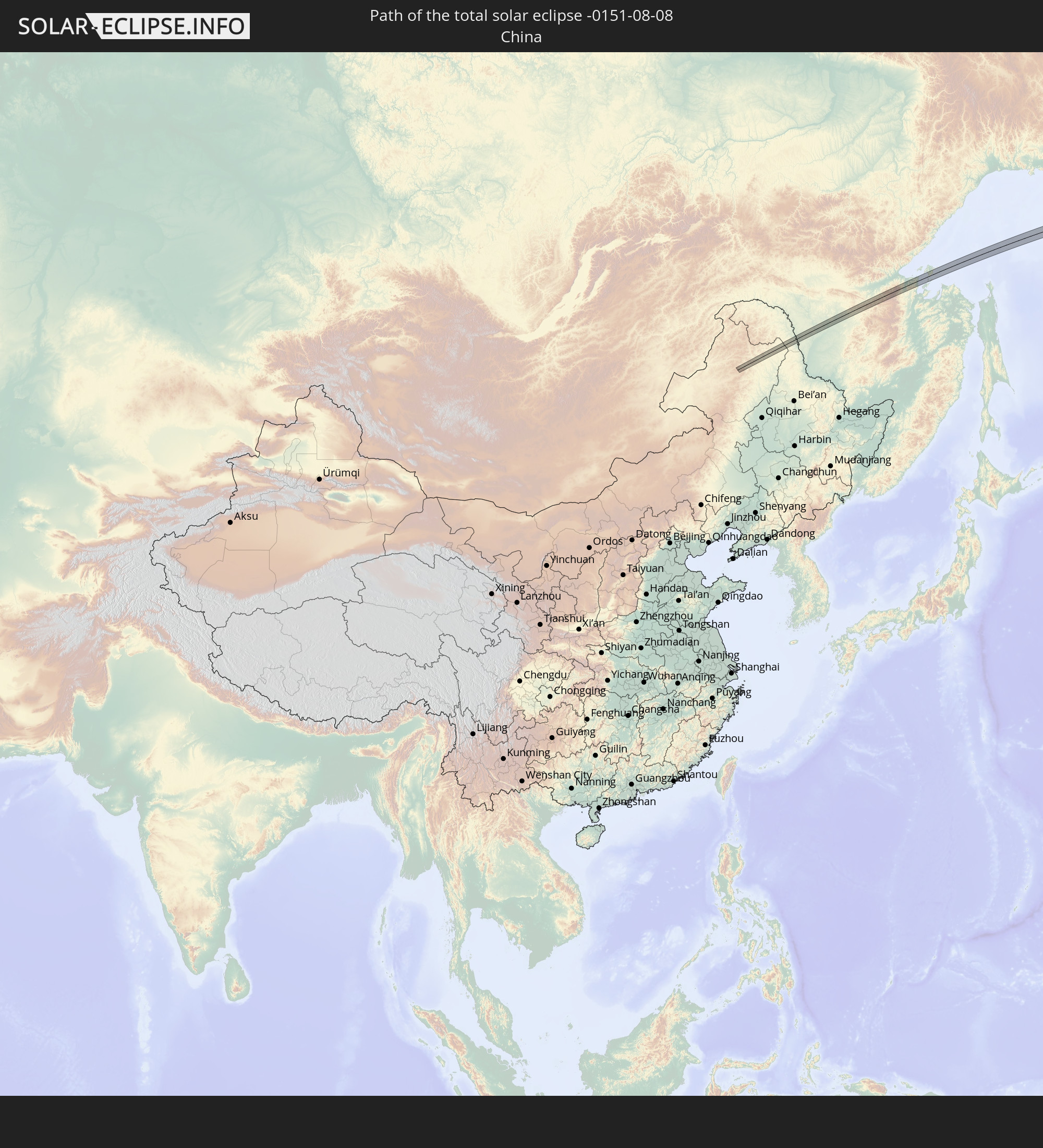 China
China
In den folgenden Ländern ist die Sonnenfinsternis partiell zu sehen
 Russia
 United States
 United States Minor Outlying Islands
 Canada
 Mexico
 Greenland
 Guatemala
 Ecuador
 El Salvador
 Honduras
 Belize
 Nicaragua
 Costa Rica
 Cuba
Cuba
 Panama
 Colombia
 Cayman Islands
 The Bahamas
 Jamaica
 Haiti
Haiti
 Turks and Caicos Islands
 Dominican Republic
 Bermuda
 Saint Pierre and Miquelon
 Iceland
 Svalbard and Jan Mayen
 China
China
 Japan
Japan
 North Korea
 Northern Mariana Islands
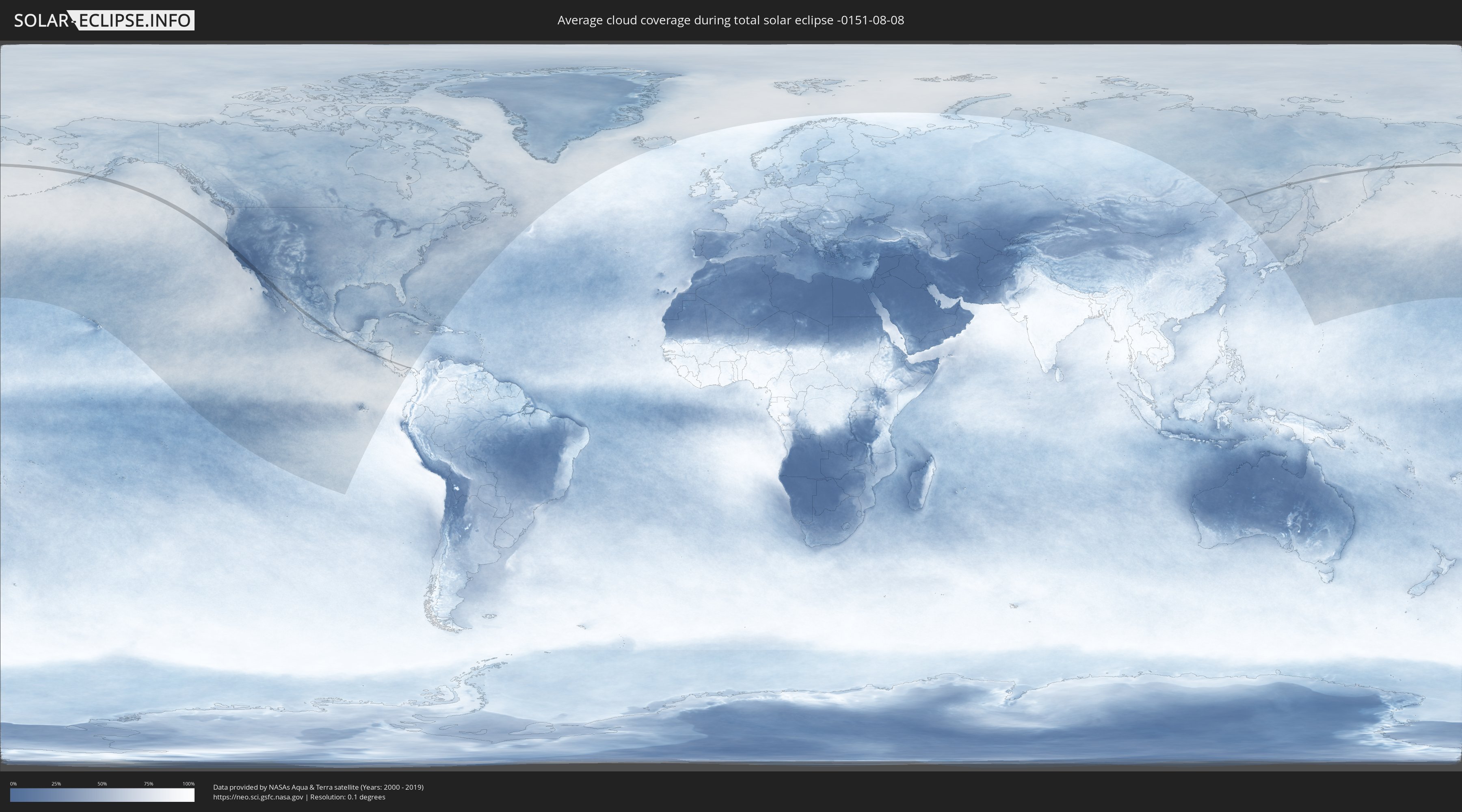
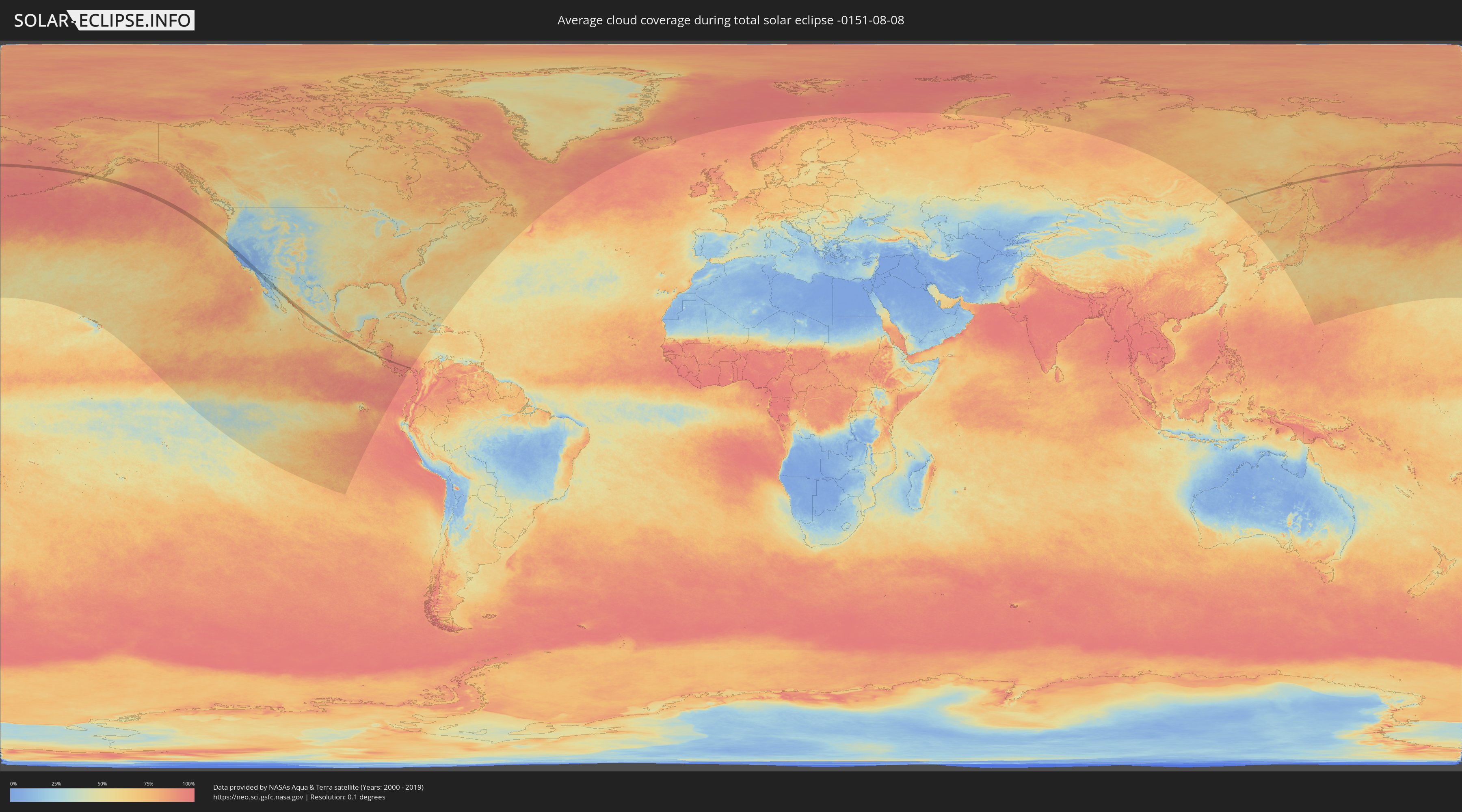
How will be the weather during the total solar eclipse on 08/08/-0151?
Where is the best place to see the total solar eclipse of 08/08/-0151?
The following maps show the average cloud coverage for the day of the total solar eclipse.
With the help of these maps, it is possible to find the place along the eclipse path, which has the best
chance of a cloudless sky.
Nevertheless, you should consider local circumstances and inform about the weather of your chosen
observation site.
The data is provided by NASAs satellites
AQUA and TERRA.
The cloud maps are averaged over a period of 19 years (2000 - 2019).
Detailed country maps
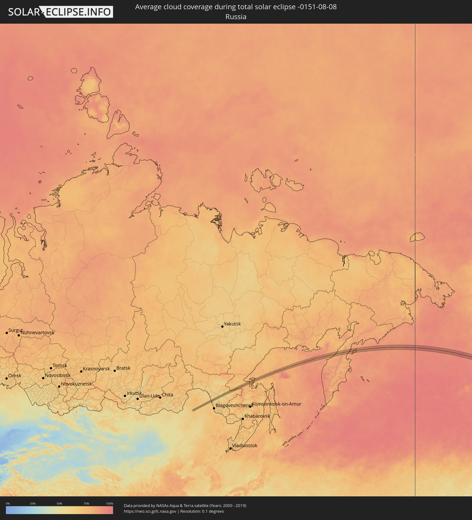 Russia
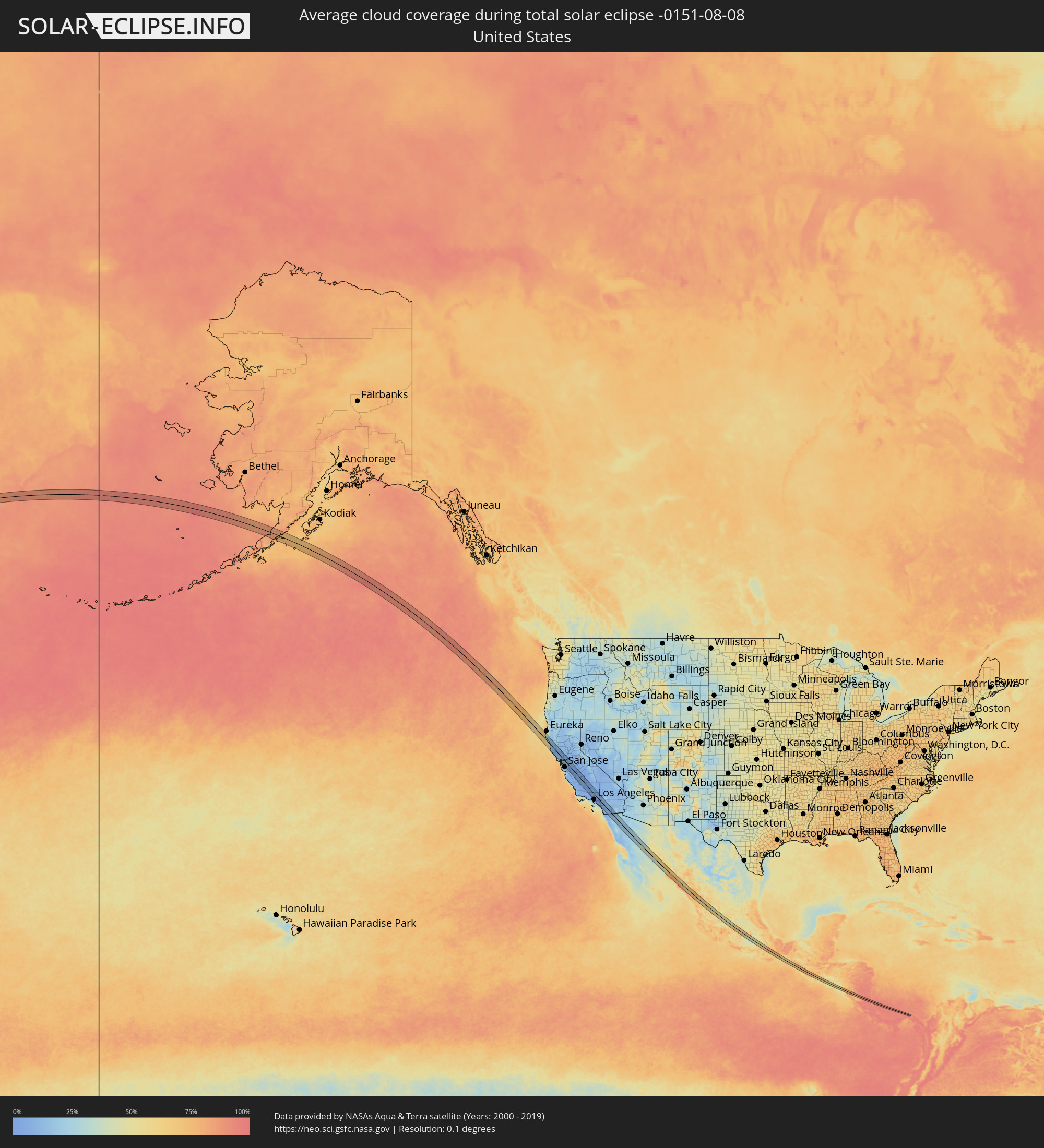 United States
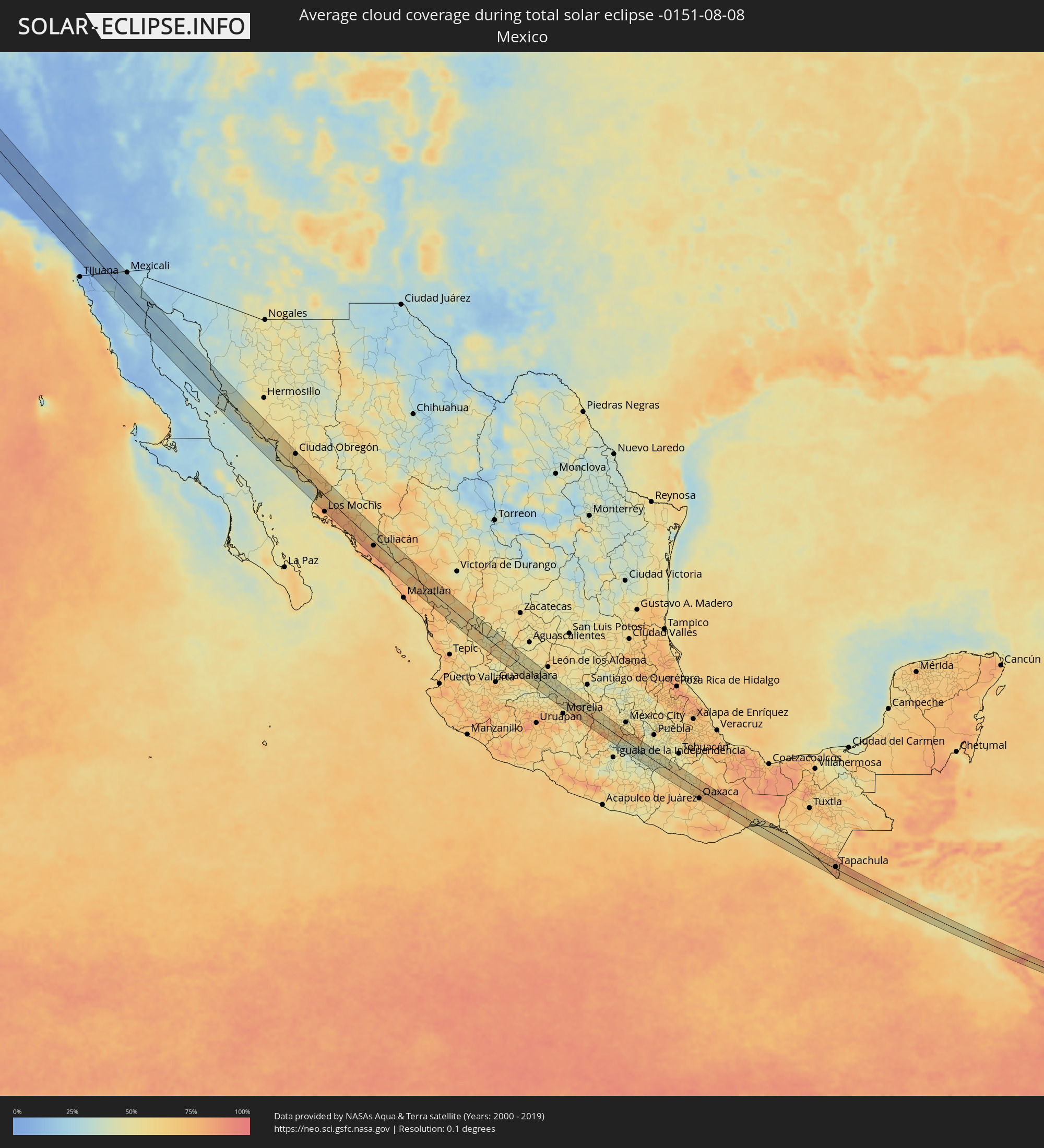 Mexico
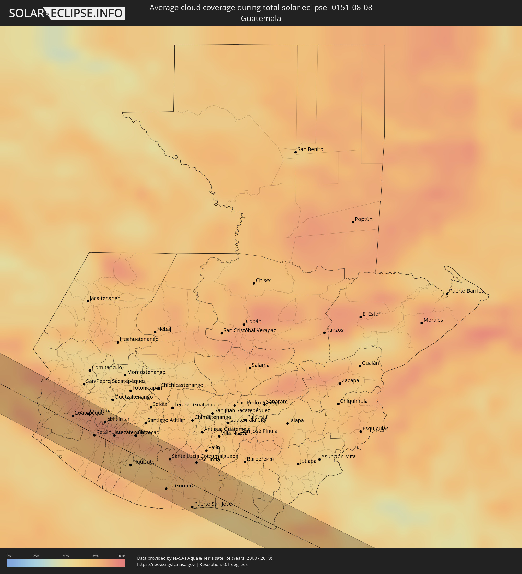 Guatemala
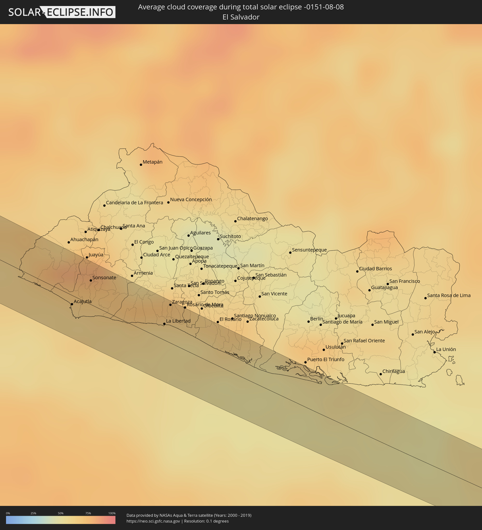 El Salvador
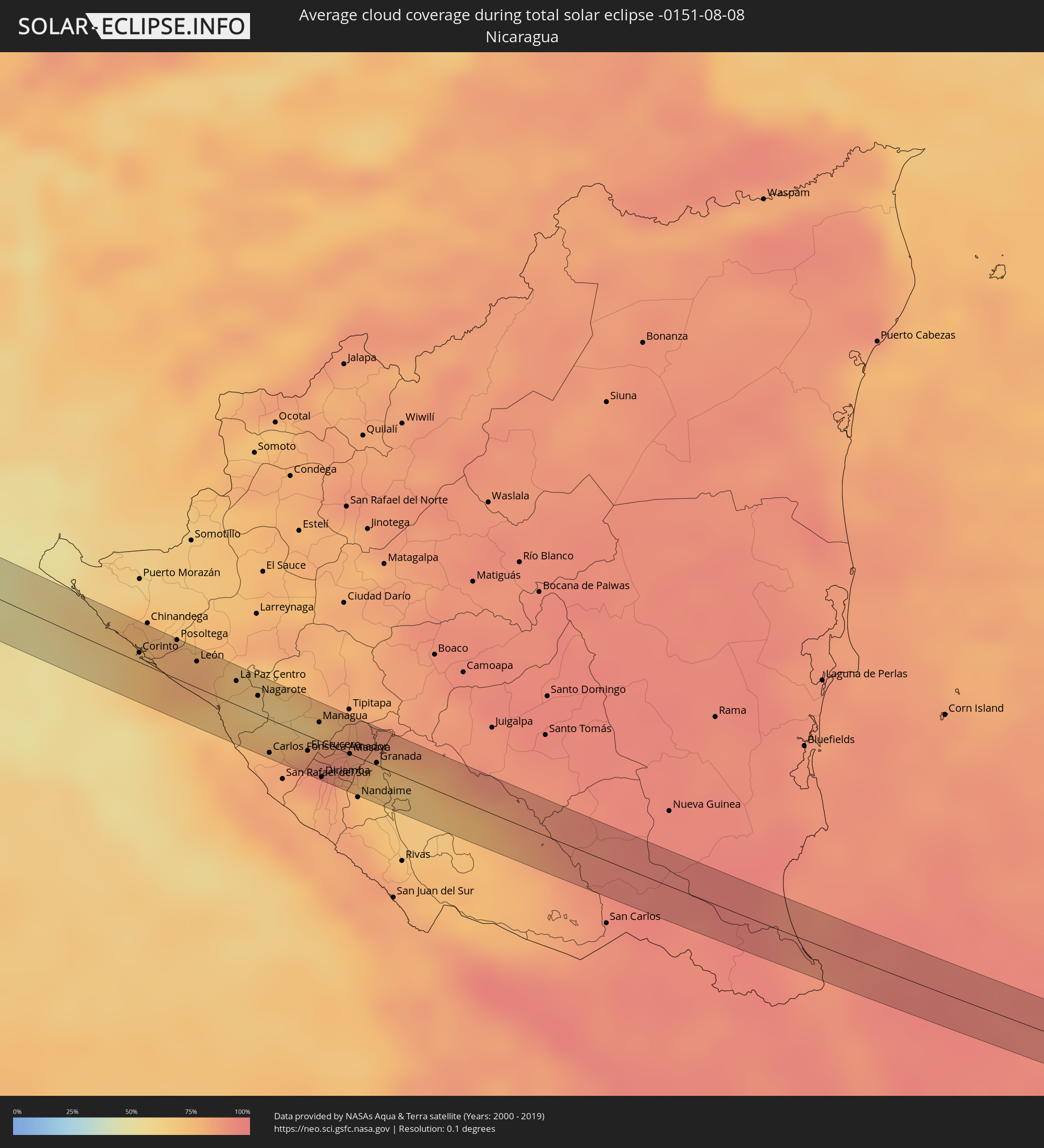 Nicaragua
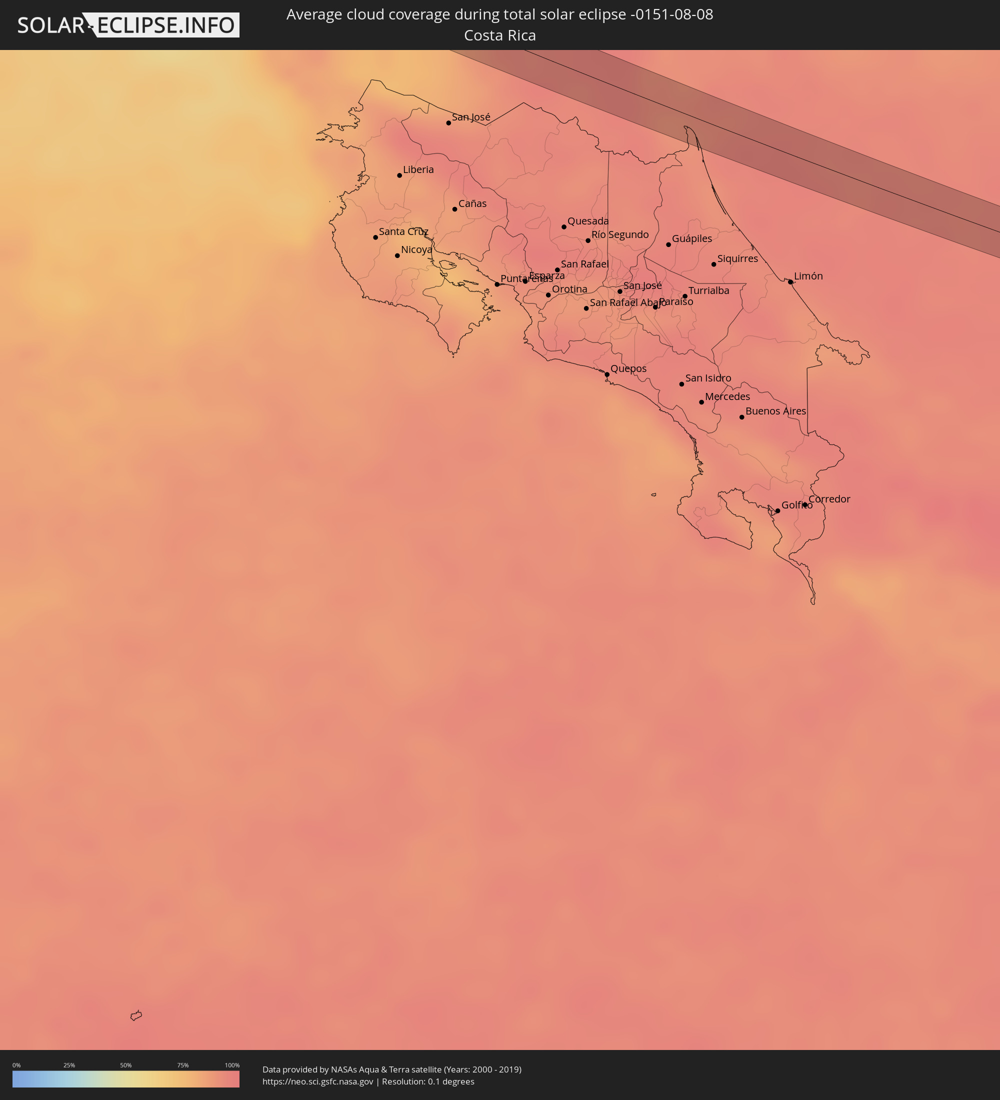 Costa Rica
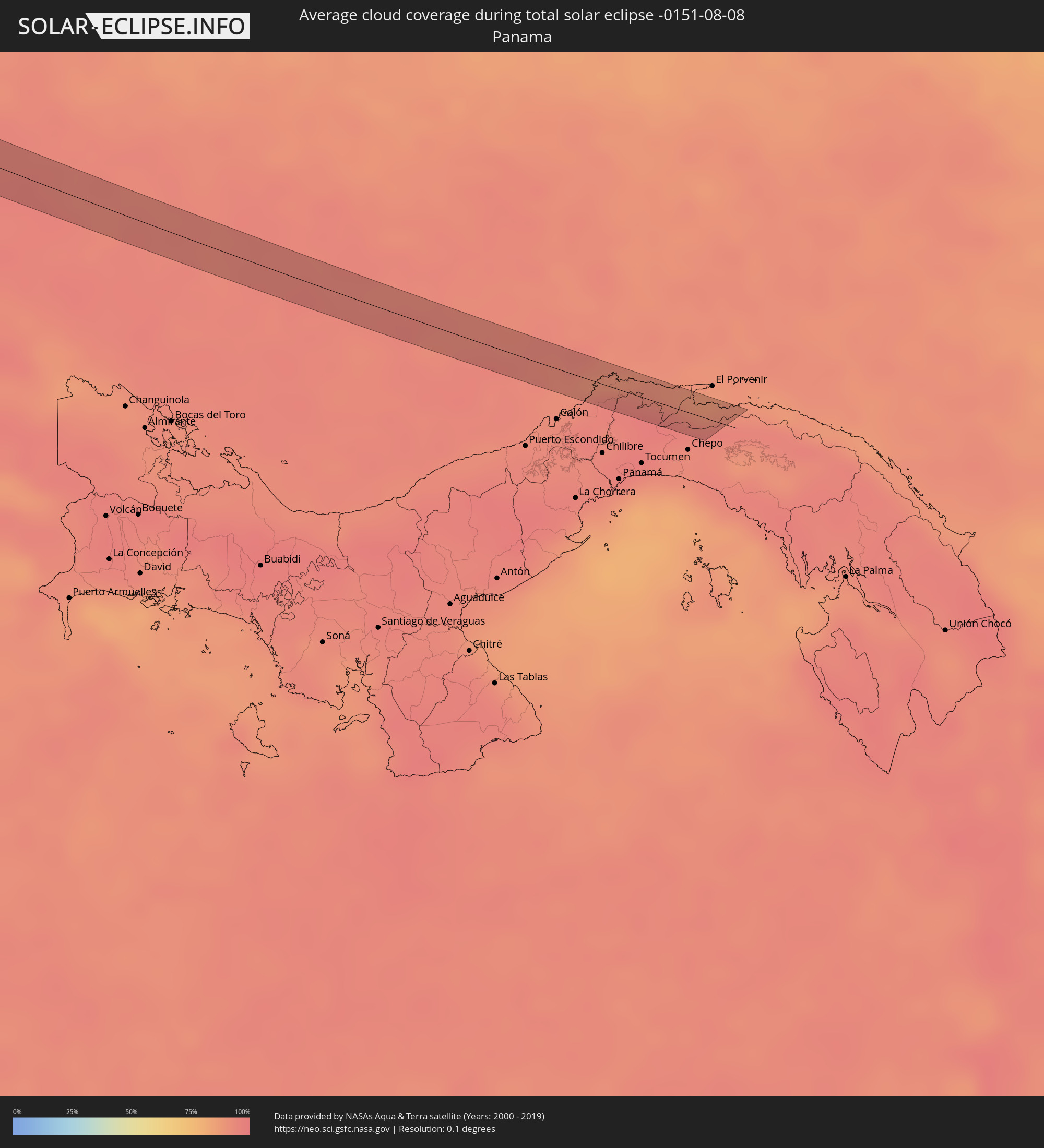 Panama
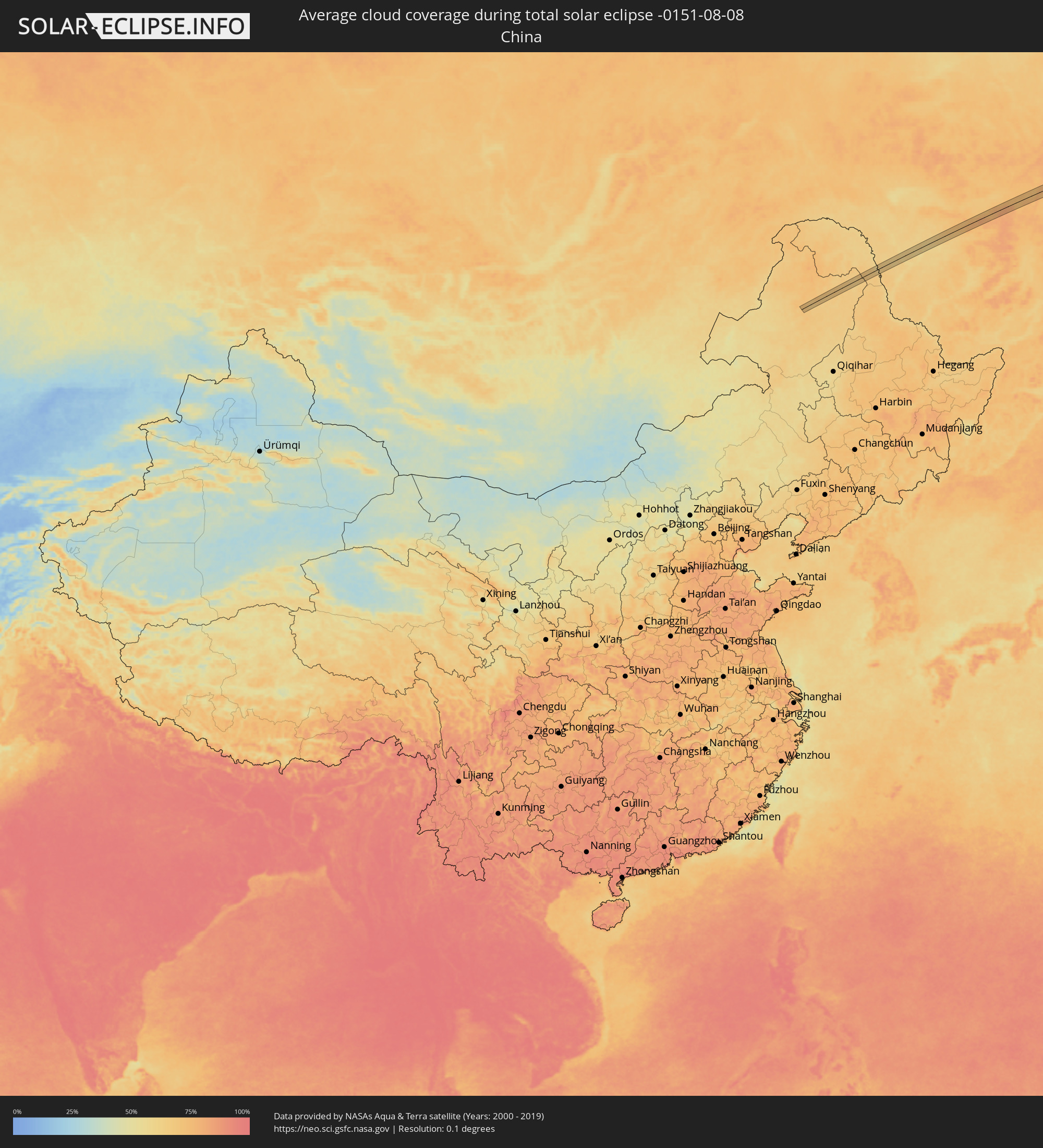 China
China
Cities inside the path of the eclipse
The following table shows all locations with a population of more than 5,000 inside the eclipse path. Cities which have more than 100,000 inhabitants are marked bold. A click at the locations opens a detailed map.
| City | Type | Eclipse duration | Local time of max. eclipse | Distance to central line | Ø Cloud coverage |
|
Santa Rosa, California
|
total | - | 14:25:23 UTC-08:00 | 18 km | 16% |
|
Richmond, California
|
total | - | 14:26:48 UTC-08:00 | 31 km | 30% |
|
Oakland, California
|
total | - | 14:27:09 UTC-08:00 | 36 km | 28% |
|
Vallejo, California
|
total | - | 14:26:34 UTC-08:00 | 13 km | 16% |
|
Hayward, California
|
total | - | 14:27:38 UTC-08:00 | 34 km | 16% |
|
Fairfield, California
|
total | - | 14:26:32 UTC-08:00 | 12 km | 10% |
|
Concord, California
|
total | - | 14:27:05 UTC-08:00 | 7 km | 8% |
|
Fremont, California
|
total | - | 14:27:59 UTC-08:00 | 36 km | 20% |
|
Antioch, California
|
total | - | 14:27:17 UTC-08:00 | 9 km | 5% |
|
Stockton, California
|
total | - | 14:27:57 UTC-08:00 | 40 km | 7% |
|
Modesto, California
|
total | - | 14:28:55 UTC-08:00 | 36 km | 8% |
|
Bakersfield, California
|
total | - | 14:35:35 UTC-08:00 | 2 km | 3% |
|
Santa Clarita, California
|
total | - | 14:38:02 UTC-08:00 | 38 km | 3% |
|
North Glendale, California
|
total | - | 14:38:47 UTC-08:00 | 36 km | 4% |
|
East Los Angeles, California
|
total | - | 14:39:09 UTC-08:00 | 40 km | 6% |
|
Lancaster, California
|
total | - | 14:37:50 UTC-08:00 | 12 km | 5% |
|
West Covina, California
|
total | - | 14:39:18 UTC-08:00 | 21 km | 3% |
|
Anaheim, California
|
total | - | 14:39:48 UTC-08:00 | 36 km | 7% |
|
Irvine, California
|
total | - | 14:40:13 UTC-08:00 | 42 km | 8% |
|
Pomona, California
|
total | - | 14:39:31 UTC-08:00 | 9 km | 3% |
|
Mission Viejo, California
|
total | - | 14:40:30 UTC-08:00 | 37 km | 11% |
|
Rancho Cucamonga, California
|
total | - | 14:39:34 UTC-08:00 | 6 km | 5% |
|
Corona, California
|
total | - | 14:40:04 UTC-08:00 | 9 km | 3% |
|
Riverside, California
|
total | - | 14:40:04 UTC-08:00 | 8 km | 6% |
|
San Bernardino, California
|
total | - | 14:39:52 UTC-08:00 | 27 km | 6% |
|
Vista, California
|
total | - | 14:41:44 UTC-08:00 | 37 km | 9% |
|
Moreno Valley, California
|
total | - | 14:40:16 UTC-08:00 | 18 km | 7% |
|
Murrieta, California
|
total | - | 14:41:03 UTC-08:00 | 9 km | 6% |
|
Escondido, California
|
total | - | 14:42:03 UTC-08:00 | 33 km | 8% |
|
Tecate, Baja California
|
total | - | 14:55:31 UTC-07:48 | 42 km | 9% |
|
Heroica Guaymas, Sonora
|
total | - | 15:33:37 UTC-07:23 | 1 km | 44% |
|
Ciudad Obregón, Sonora
|
total | - | 15:35:07 UTC-07:23 | 33 km | 58% |
|
Navojoa, Sonora
|
total | - | 15:36:14 UTC-07:23 | 34 km | 67% |
|
Los Mochis, Sinaloa
|
total | - | 15:57:06 UTC-07:05 | 38 km | 76% |
|
Guasave, Sinaloa
|
total | - | 15:57:51 UTC-07:05 | 20 km | 81% |
|
Guamúchil, Sinaloa
|
total | - | 15:58:17 UTC-07:05 | 2 km | 77% |
|
Culiacán, Sinaloa
|
total | - | 15:59:54 UTC-07:05 | 11 km | 75% |
|
Arandas, Jalisco
|
total | - | 16:38:26 UTC-06:36 | 30 km | 60% |
|
San Juan de los Lagos, Jalisco
|
total | - | 16:37:32 UTC-06:36 | 19 km | 51% |
|
San Francisco del Rincón, Guanajuato
|
total | - | 16:38:06 UTC-06:36 | 29 km | 46% |
|
Irapuato, Guanajuato
|
total | - | 16:38:50 UTC-06:36 | 30 km | 46% |
|
Valle de Santiago, Guanajuato
|
total | - | 16:39:21 UTC-06:36 | 15 km | 50% |
|
Salamanca, Guanajuato
|
total | - | 16:39:04 UTC-06:36 | 31 km | 47% |
|
Uriangato, Guanajuato
|
total | - | 16:39:46 UTC-06:36 | 7 km | 54% |
|
Acámbaro, Guanajuato
|
total | - | 16:40:05 UTC-06:36 | 11 km | 60% |
|
Ciudad Hidalgo, Michoacán
|
total | - | 16:40:41 UTC-06:36 | 9 km | 66% |
|
Heróica Zitácuaro, Michoacán
|
total | - | 16:41:09 UTC-06:36 | 20 km | 68% |
|
Toluca, México
|
total | - | 16:41:35 UTC-06:36 | 9 km | 58% |
|
Cuernavaca, Morelos
|
total | - | 16:42:16 UTC-06:36 | 1 km | 46% |
|
Yautepec, Morelos
|
total | - | 16:42:23 UTC-06:36 | 7 km | 46% |
|
Cuautla Morelos, Morelos
|
total | - | 16:42:32 UTC-06:36 | 7 km | 44% |
|
Izúcar de Matamoros, Puebla
|
total | - | 16:42:58 UTC-06:36 | 17 km | 42% |
|
Ciudad de Huajuapan de León, Oaxaca
|
total | - | 16:44:19 UTC-06:36 | 17 km | 53% |
|
Oaxaca, Oaxaca
|
total | - | 16:45:38 UTC-06:36 | 26 km | 68% |
|
Santo Domingo Tehuantepec, Oaxaca
|
total | - | 16:46:55 UTC-06:36 | 14 km | 68% |
|
Salina Cruz, Oaxaca
|
total | - | 16:47:08 UTC-06:36 | 25 km | 63% |
|
Juchitán de Zaragoza, Oaxaca
|
total | - | 16:46:47 UTC-06:36 | 9 km | 57% |
|
Tapachula, Chiapas
|
total | - | 16:49:07 UTC-06:36 | 6 km | 82% |
|
Ayutla, San Marcos
|
total | - | 17:23:58 UTC-06:02 | 11 km | 74% |
|
Malacatán, San Marcos
|
total | - | 17:23:39 UTC-06:02 | 16 km | 73% |
|
Pajapita, San Marcos
|
total | - | 17:23:54 UTC-06:02 | 1 km | 72% |
|
San Pablo, San Marcos
|
total | - | 17:23:38 UTC-06:02 | 21 km | 76% |
|
Nuevo Progreso, San Marcos
|
total | - | 17:23:48 UTC-06:02 | 13 km | 76% |
|
Coatepeque, Quetzaltenango
|
total | - | 17:23:56 UTC-06:02 | 5 km | 72% |
|
Flores Costa Cuca, Quetzaltenango
|
total | - | 17:24:02 UTC-06:02 | 1 km | 73% |
|
El Quetzal, San Marcos
|
total | - | 17:23:51 UTC-06:02 | 14 km | 83% |
|
Retalhuleu, Retalhuleu
|
total | - | 17:24:10 UTC-06:02 | 1 km | 76% |
|
San Sebastián, Retalhuleu
|
total | - | 17:24:07 UTC-06:02 | 3 km | 75% |
|
San Felipe, Retalhuleu
|
total | - | 17:24:03 UTC-06:02 | 10 km | 76% |
|
El Palmar, Quetzaltenango
|
total | - | 17:24:01 UTC-06:02 | 15 km | 83% |
|
Cuyotenango, Suchitepeque
|
total | - | 17:24:10 UTC-06:02 | 4 km | 72% |
|
San Francisco Zapotitlán, Suchitepeque
|
total | - | 17:24:06 UTC-06:02 | 11 km | 76% |
|
Mazatenango, Suchitepeque
|
total | - | 17:24:10 UTC-06:02 | 7 km | 71% |
|
Samayac, Quetzaltenango
|
total | - | 17:24:06 UTC-06:02 | 14 km | 76% |
|
San Antonio Suchitepéquez, Suchitepeque
|
total | - | 17:24:10 UTC-06:02 | 11 km | 69% |
|
Tiquisate, Escuintla
|
total | - | 17:24:30 UTC-06:02 | 11 km | 76% |
|
Río Bravo, Suchitepeque
|
total | - | 17:24:21 UTC-06:02 | 3 km | 69% |
|
Chicacao, Suchitepeque
|
total | - | 17:24:10 UTC-06:02 | 16 km | 68% |
|
Nueva Concepción, Escuintla
|
total | - | 17:24:36 UTC-06:02 | 16 km | 75% |
|
Santa Bárbara, Suchitepeque
|
total | - | 17:24:18 UTC-06:02 | 11 km | 70% |
|
Patulul, Suchitepeque
|
total | - | 17:24:19 UTC-06:02 | 12 km | 70% |
|
La Gomera, Escuintla
|
total | - | 17:24:46 UTC-06:02 | 15 km | 76% |
|
Santa Lucía Cotzumalguapa, Escuintla
|
total | - | 17:24:26 UTC-06:02 | 11 km | 75% |
|
Masagua, Escuintla
|
total | - | 17:24:36 UTC-06:02 | 7 km | 75% |
|
Puerto San José, Escuintla
|
total | - | 17:24:58 UTC-06:02 | 19 km | 61% |
|
Escuintla, Escuintla
|
total | - | 17:24:28 UTC-06:02 | 20 km | 74% |
|
Chiquimulilla, Santa Rosa
|
total | - | 17:24:45 UTC-06:02 | 17 km | 71% |
|
Tacuba, Ahuachapán
|
total | - | 17:30:14 UTC-05:56 | 21 km | 79% |
|
Concepción de Ataco, Ahuachapán
|
total | - | 17:30:17 UTC-05:56 | 22 km | 79% |
|
Acajutla, Sonsonate
|
total | - | 17:30:38 UTC-05:56 | 5 km | 60% |
|
San Antonio del Monte, Sonsonate
|
total | - | 17:30:28 UTC-05:56 | 12 km | 66% |
|
Nahuizalco, Sonsonate
|
total | - | 17:30:23 UTC-05:56 | 18 km | 73% |
|
Sonsonate, Sonsonate
|
total | - | 17:30:28 UTC-05:56 | 13 km | 66% |
|
Sonzacate, Sonsonate
|
total | - | 17:30:27 UTC-05:56 | 15 km | 66% |
|
Izalco, Sonsonate
|
total | - | 17:30:26 UTC-05:56 | 18 km | 66% |
|
La Libertad, La Libertad
|
total | - | 17:30:44 UTC-05:56 | 9 km | 56% |
|
Zaragoza, La Libertad
|
total | - | 17:30:37 UTC-05:56 | 20 km | 61% |
|
Corinto, Chinandega
|
total | - | 17:43:24 UTC-05:45 | 5 km | 68% |
|
El Realejo, Chinandega
|
total | - | 17:43:19 UTC-05:45 | 11 km | 68% |
|
Posoltega, Chinandega
|
total | - | 17:43:18 UTC-05:45 | 20 km | 78% |
|
León, León
|
total | - | 17:43:25 UTC-05:45 | 13 km | 73% |
|
La Paz Centro, León
|
total | - | 17:43:31 UTC-05:45 | 12 km | 72% |
|
Nagarote, León
|
total | - | 17:43:35 UTC-05:45 | 9 km | 71% |
|
Carlos Fonseca Amador, Managua
|
total | - | 17:43:55 UTC-05:45 | 17 km | 83% |
|
Ciudad Sandino, Managua
|
total | - | 17:43:41 UTC-05:45 | 8 km | 80% |
|
El Crucero, Managua
|
total | - | 17:43:53 UTC-05:45 | 8 km | 87% |
|
Managua, Managua
|
total | - | 17:43:42 UTC-05:45 | 9 km | 87% |
|
Diriamba, Carazo
|
total | - | 17:44:01 UTC-05:45 | 18 km | 82% |
|
Dolores, Carazo
|
total | - | 17:44:01 UTC-05:45 | 17 km | 82% |
|
Ticuantepe, Managua
|
total | - | 17:43:49 UTC-05:45 | 1 km | 89% |
|
San Marcos, Carazo
|
total | - | 17:43:57 UTC-05:45 | 11 km | 82% |
|
Jinotepe, Carazo
|
total | - | 17:44:01 UTC-05:45 | 17 km | 82% |
|
La Concepción, Masaya
|
total | - | 17:43:55 UTC-05:45 | 8 km | 82% |
|
Masatepe, Masaya
|
total | - | 17:43:56 UTC-05:45 | 8 km | 80% |
|
Nindirí, Masaya
|
total | - | 17:43:50 UTC-05:45 | 2 km | 81% |
|
Nandasmo, Masaya
|
total | - | 17:43:56 UTC-05:45 | 6 km | 80% |
|
Niquinohomo, Masaya
|
total | - | 17:43:57 UTC-05:45 | 7 km | 80% |
|
Masaya, Masaya
|
total | - | 17:43:52 UTC-05:45 | 0 km | 81% |
|
Diriomo, Granada
|
total | - | 17:43:58 UTC-05:45 | 8 km | 80% |
|
Tisma, Masaya
|
total | - | 17:43:44 UTC-05:45 | 14 km | 80% |
|
Granada, Granada
|
total | - | 17:43:54 UTC-05:45 | 1 km | 75% |
|
Oroqen Zizhiqi, Inner Mongolia
|
total | - | 04:26:37 UTC+08:00 | 0 km | 66% |
|
Shimanovsk, Amur
|
total | - | 05:06:03 UTC+08:38 | 16 km | 61% |