Total solar eclipse of 06/06/-0194
| Day of week: | Wednesday |
| Maximum duration of eclipse: | 06m26s |
| Maximum width of eclipse path: | 232 km |
| Saros cycle: | 63 |
| Coverage: | 100% |
| Magnitude: | 1.0707 |
| Gamma: | -0.1348 |
Wo kann man die Sonnenfinsternis vom 06/06/-0194 sehen?
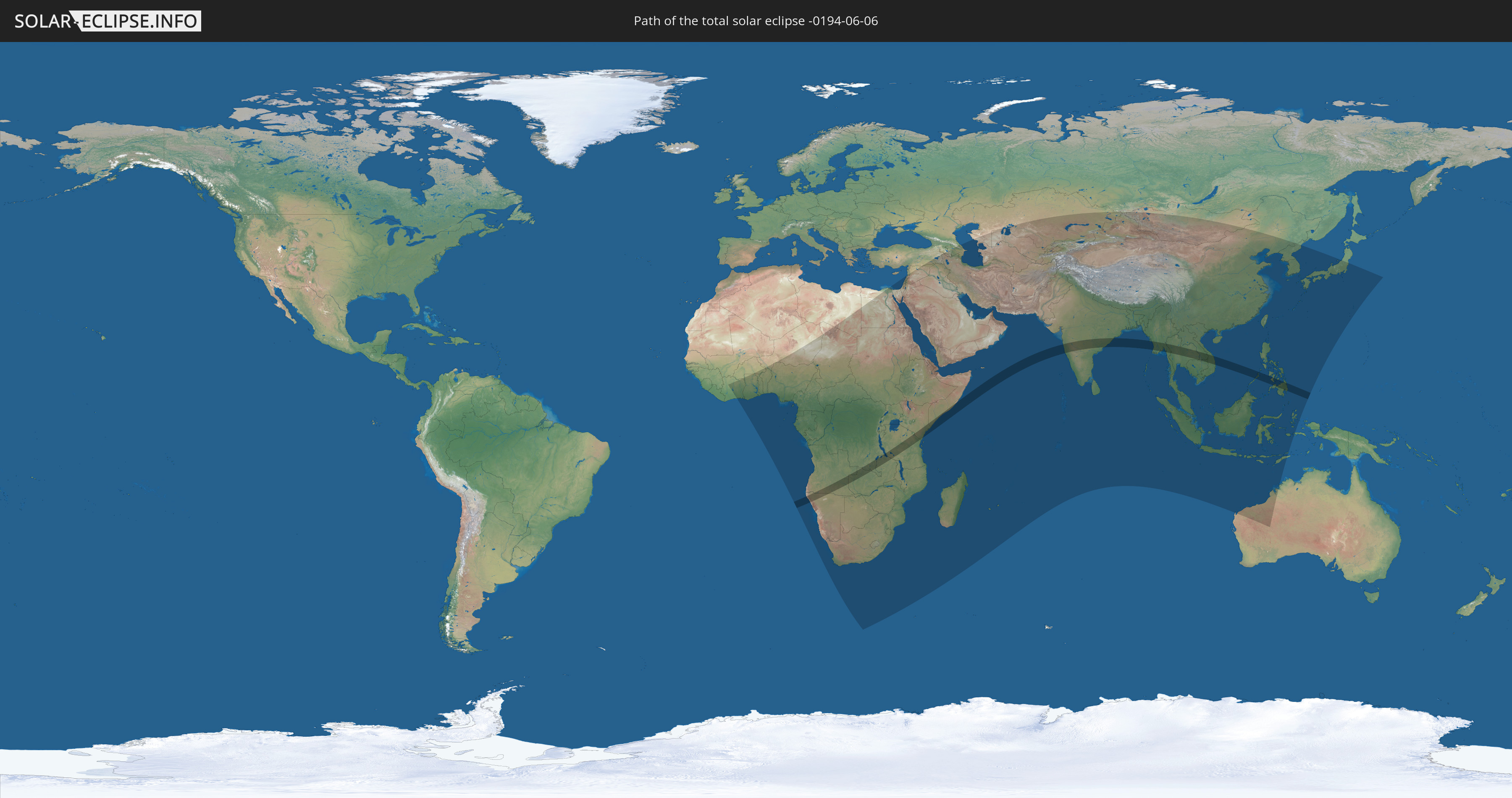
Die Sonnenfinsternis am 06/06/-0194 kann man in 98 Ländern als partielle Sonnenfinsternis beobachten.
Der Finsternispfad verläuft durch 14 Länder. Nur in diesen Ländern ist sie als total Sonnenfinsternis zu sehen.
In den folgenden Ländern ist die Sonnenfinsternis total zu sehen
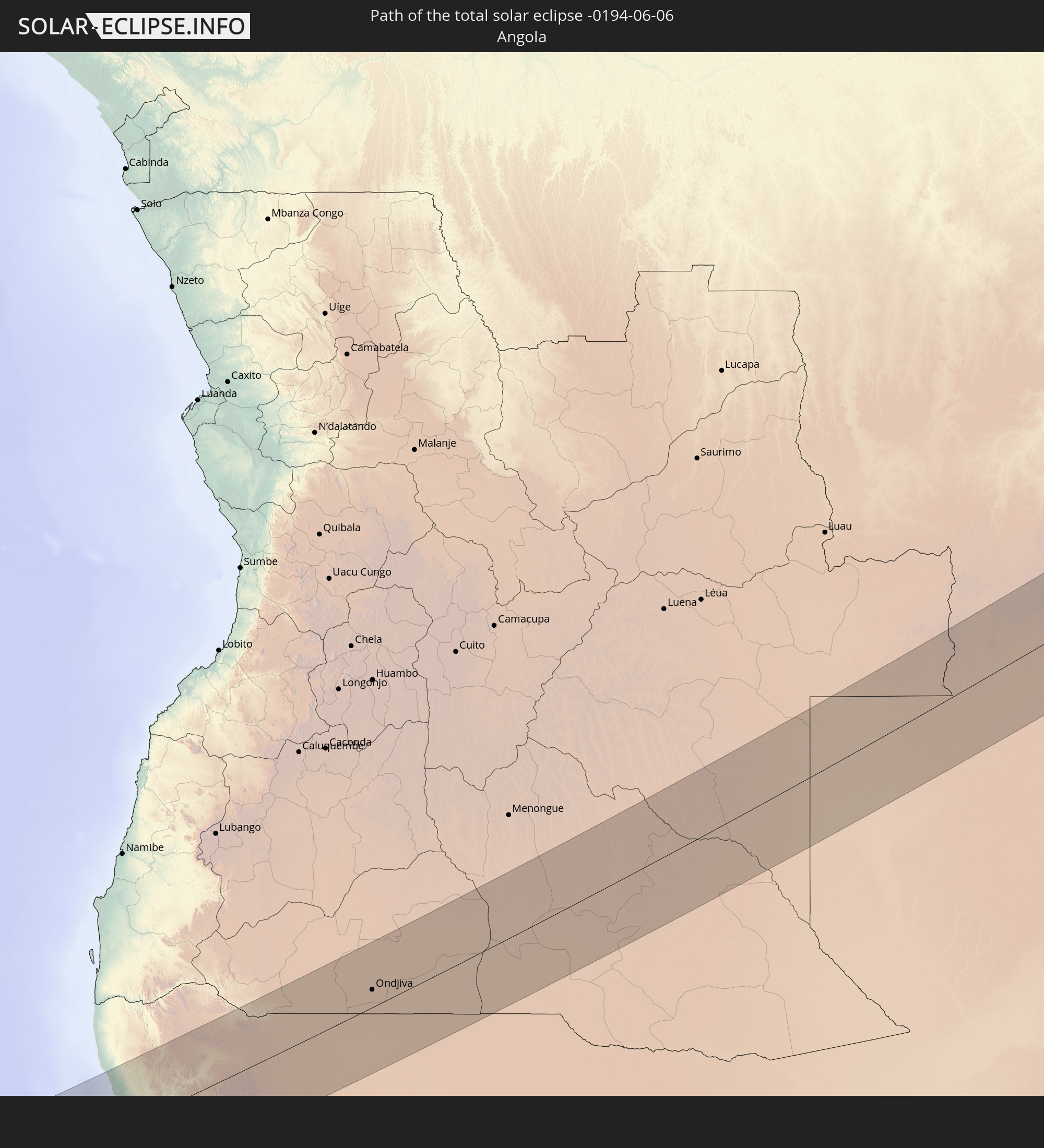 Angola
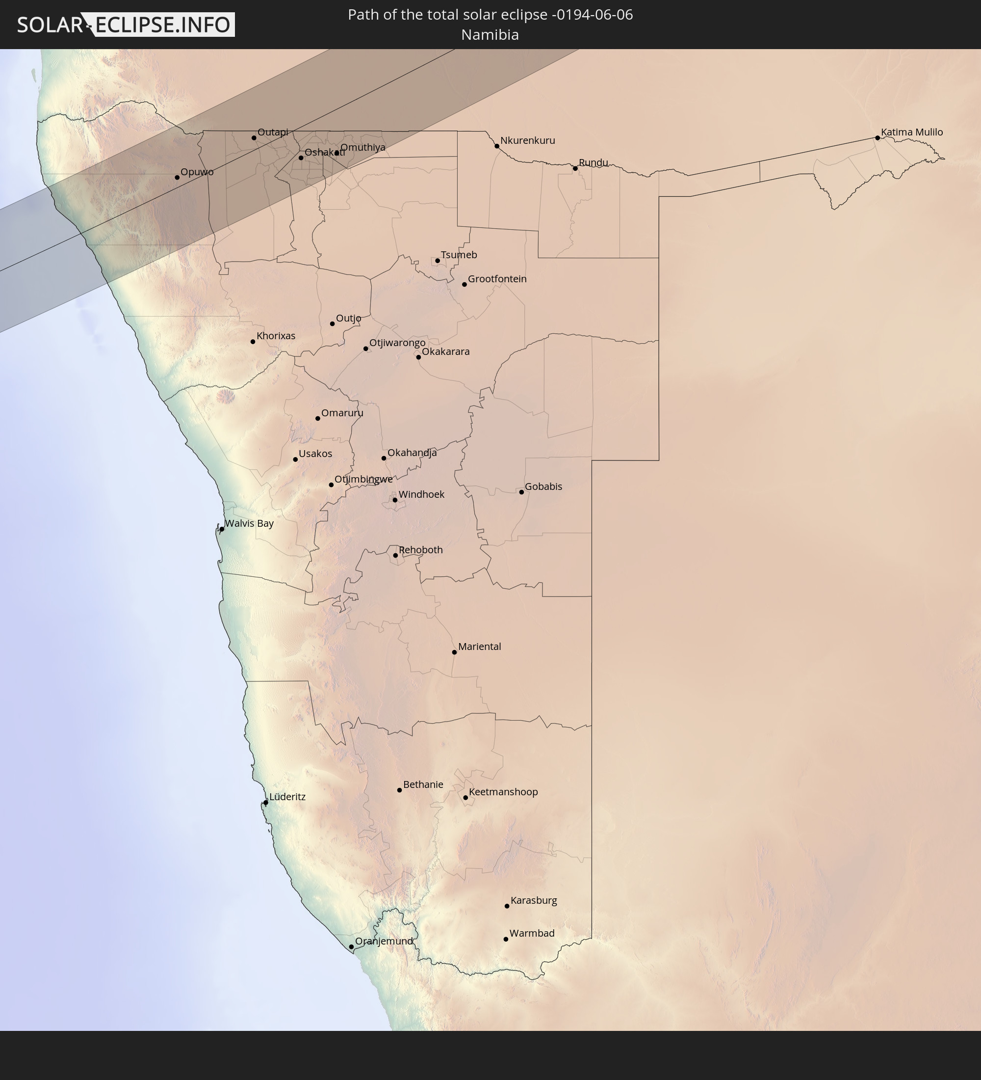 Namibia
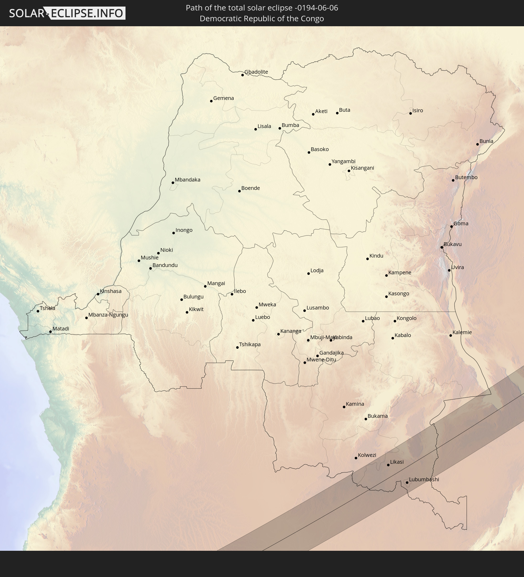 Democratic Republic of the Congo
 Zambia
 Tanzania
 Kenya
Kenya
 Somalia
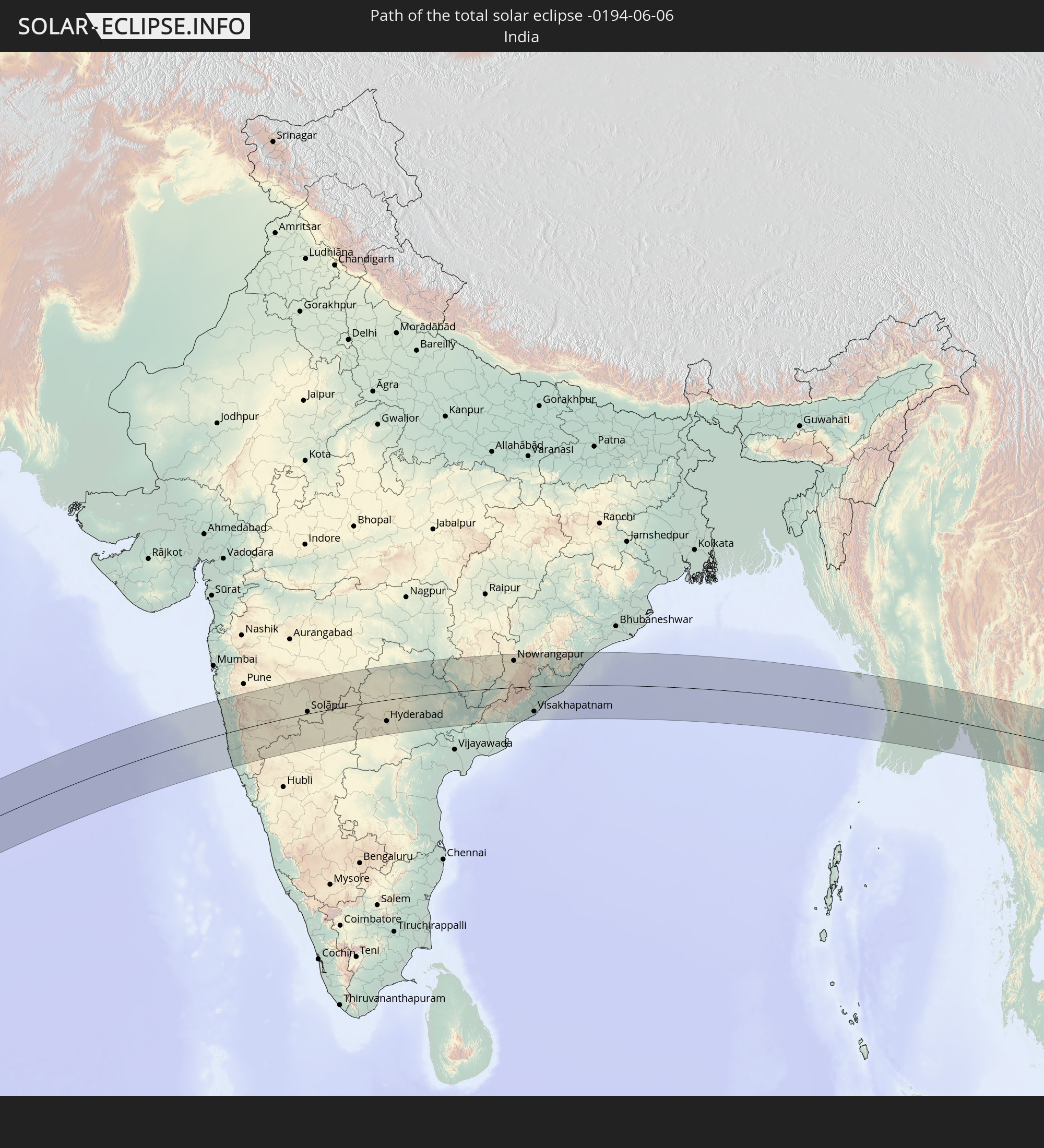 India
India
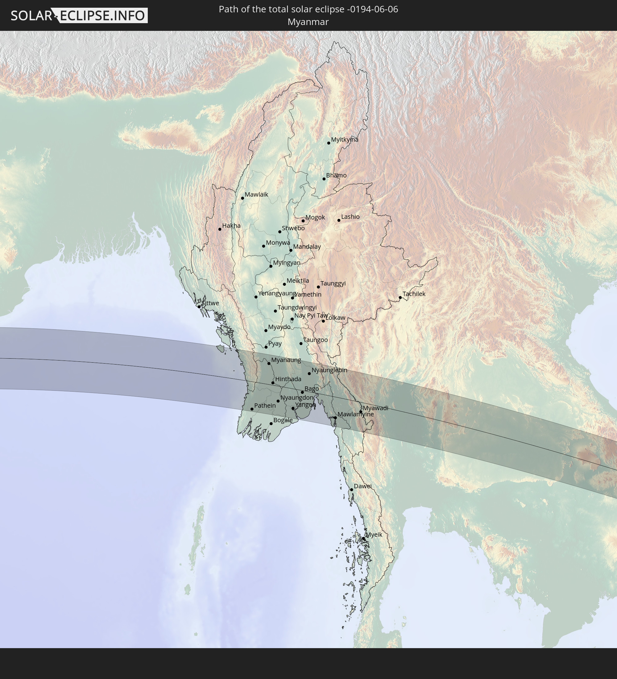 Myanmar
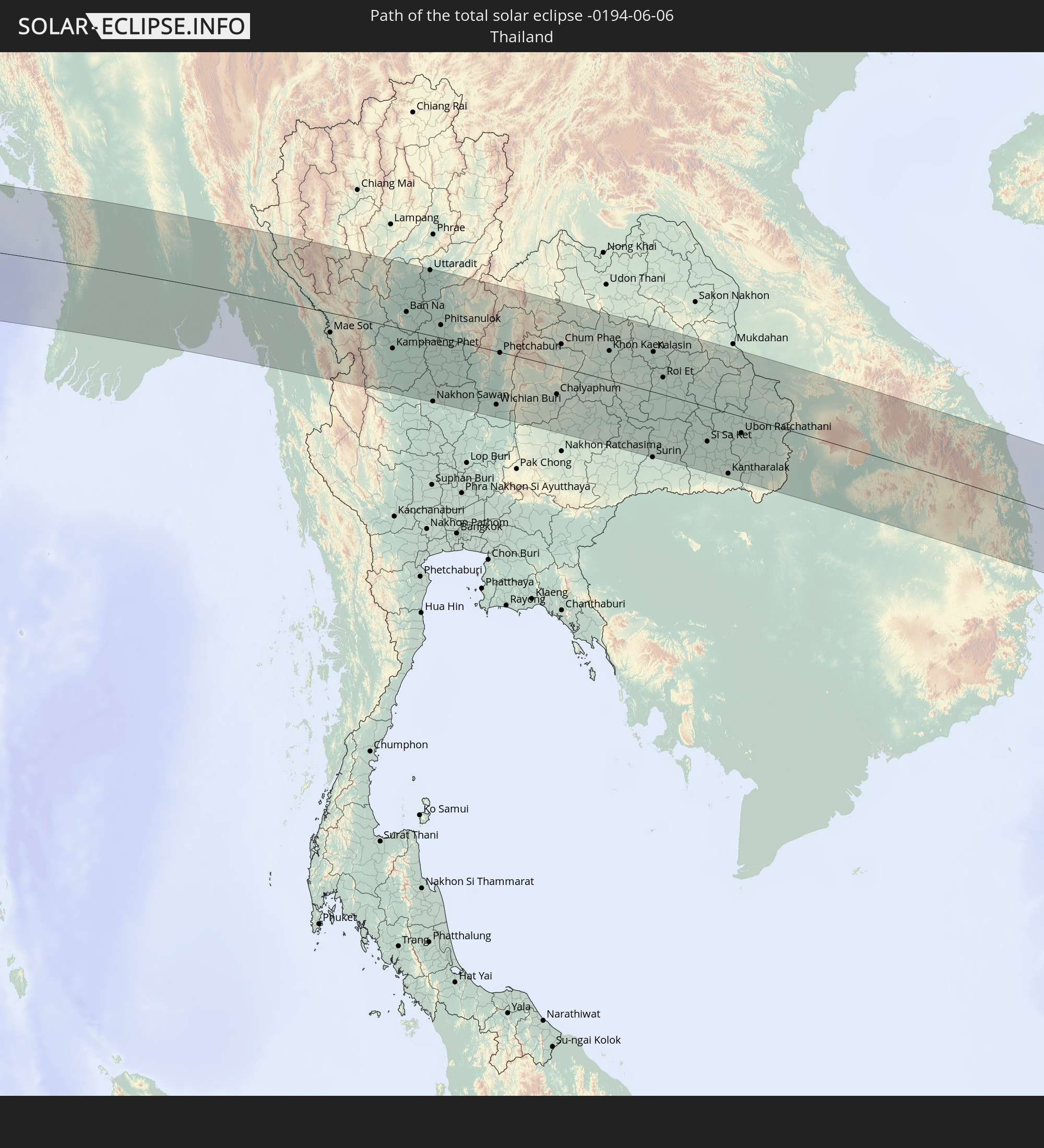 Thailand
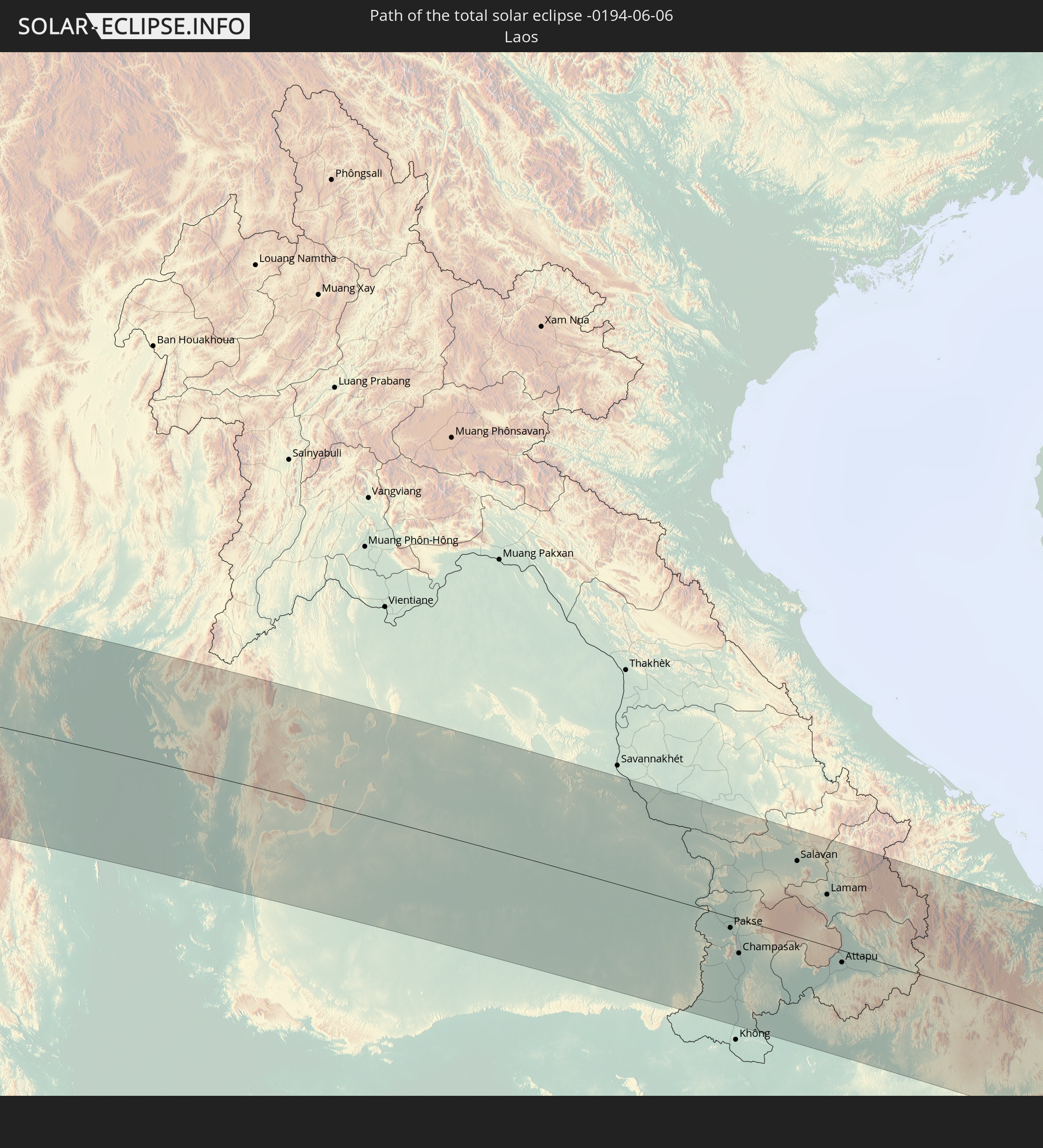 Laos
Laos
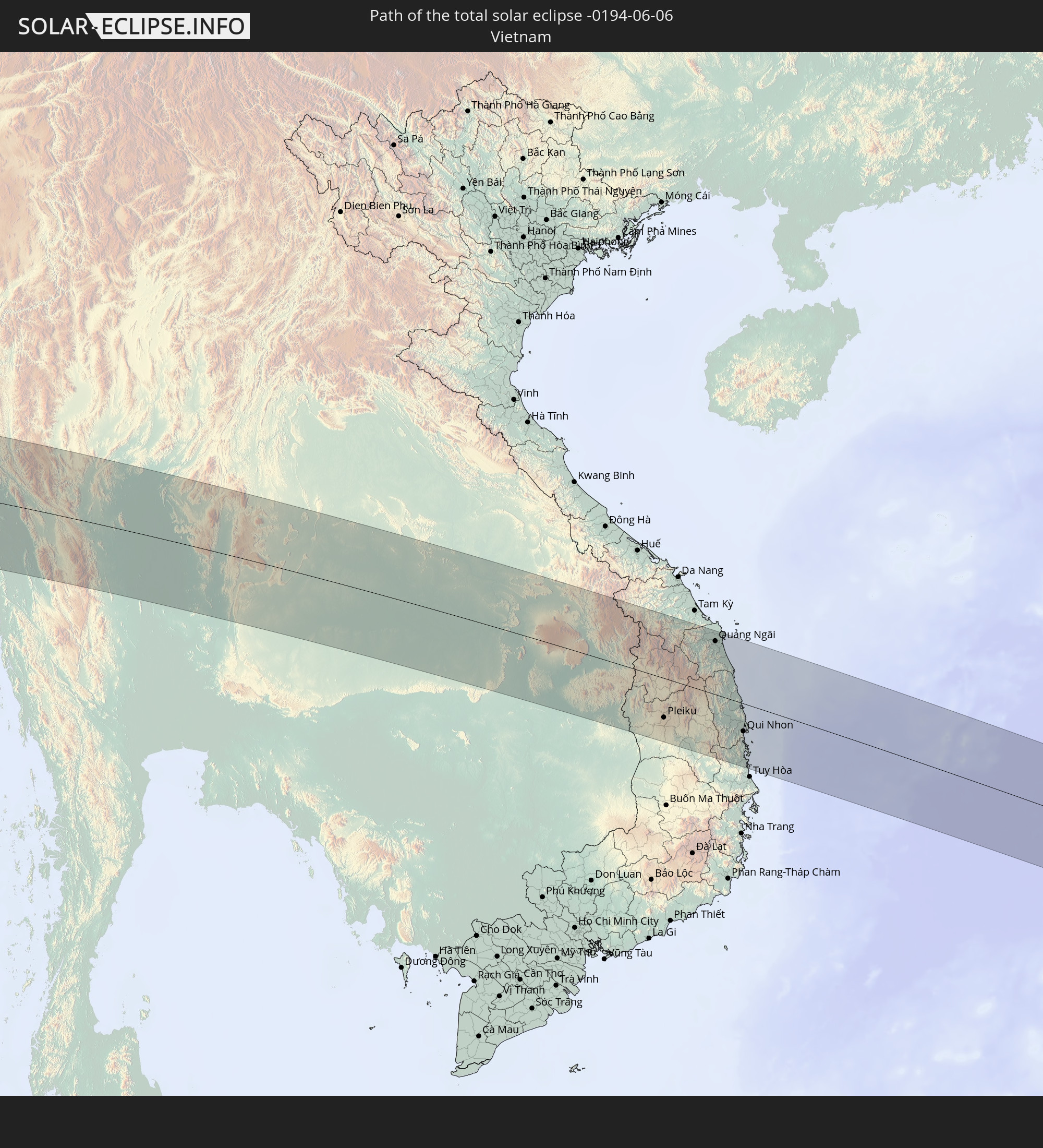 Vietnam
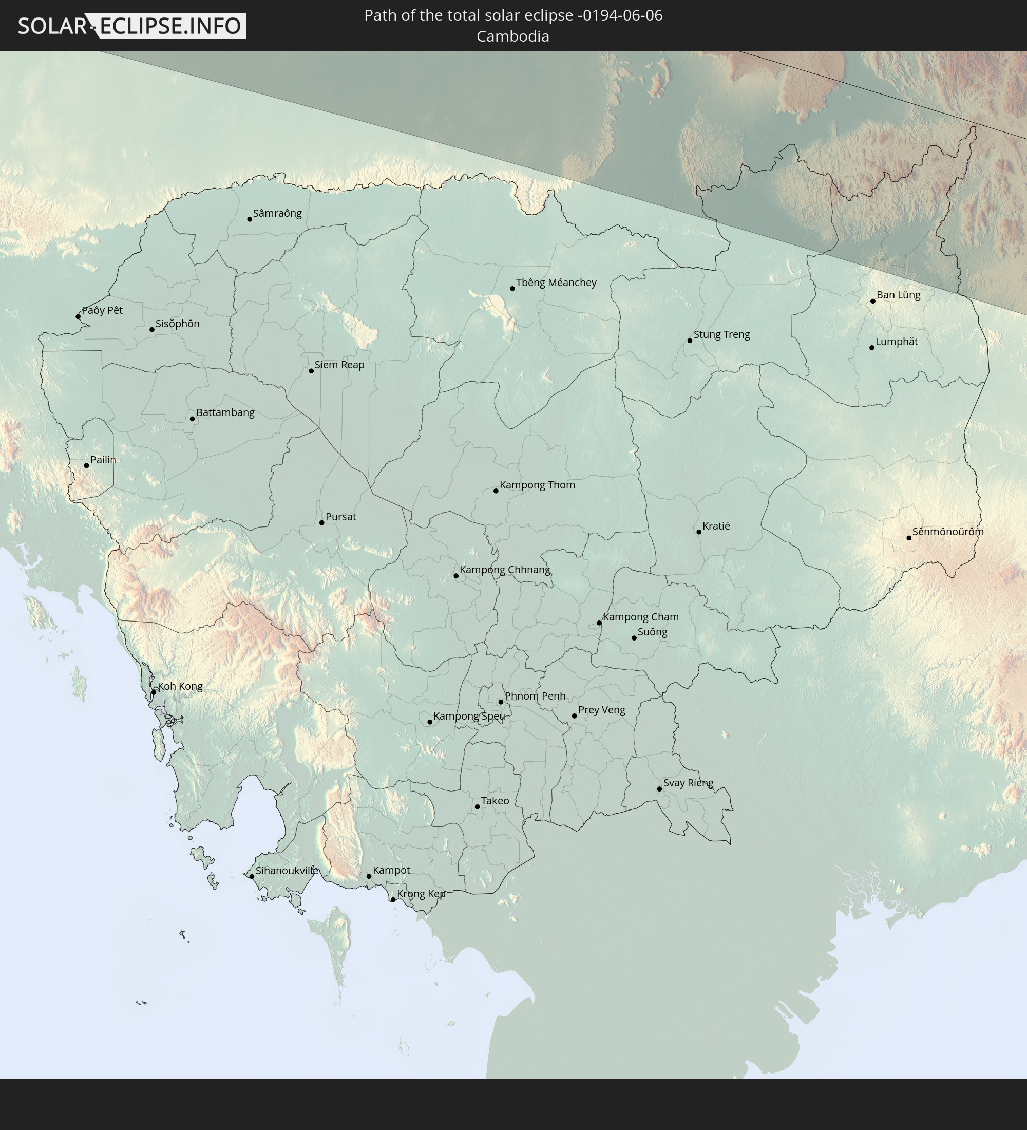 Cambodia
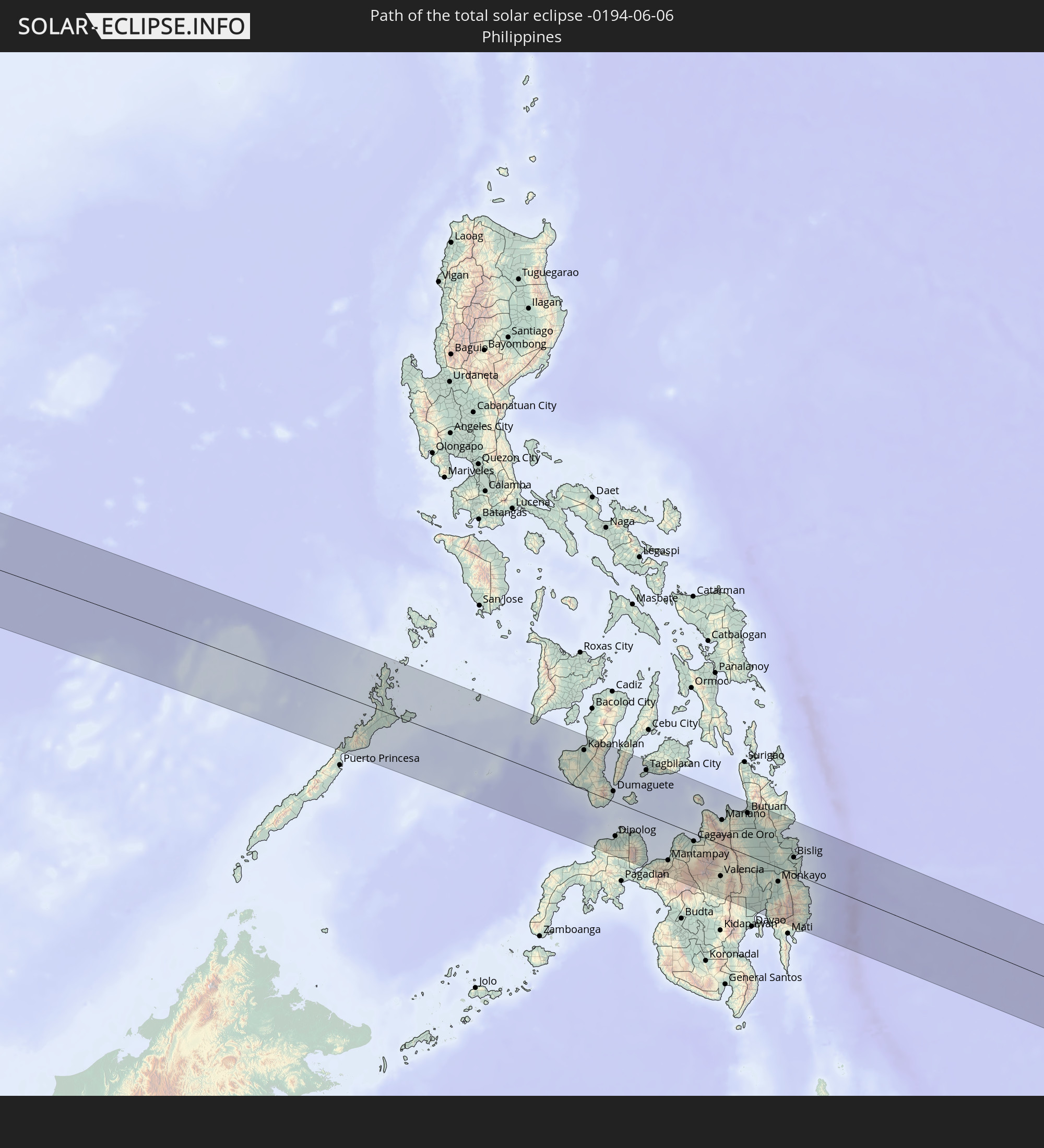 Philippines
In den folgenden Ländern ist die Sonnenfinsternis partiell zu sehen
 Russia
 Ivory Coast
 Burkina Faso
 Ghana
Ghana
 Togo
Togo
 Niger
Niger
 Benin
Benin
 Nigeria
 Equatorial Guinea
 São Tomé and Príncipe
 Cameroon
 Gabon
Gabon
 Libya
Libya
 Republic of the Congo
 Angola
 Namibia
 Democratic Republic of the Congo
 Chad
Chad
 Central African Republic
 South Africa
 Botswana
 Sudan
Sudan
 Zambia
 Egypt
Egypt
 Zimbabwe
 Turkey
 Lesotho
 Rwanda
 Burundi
 Tanzania
 Uganda
 Mozambique
 Swaziland
 Malawi
 Ethiopia
 Kenya
Kenya
 State of Palestine
 Israel
 Saudi Arabia
 Jordan
 Lebanon
 Syria
Syria
 Eritrea
 Iraq
Iraq
 French Southern and Antarctic Lands
 Somalia
 Djibouti
 Yemen
Yemen
 Madagascar
 Comoros
 Armenia
 Iran
Iran
 Azerbaijan
 Mayotte
 Seychelles
 Kazakhstan
 Kuwait
 Bahrain
 Qatar
Qatar
 United Arab Emirates
 Oman
Oman
 Turkmenistan
 Réunion
 Uzbekistan
 Mauritius
 Afghanistan
 Pakistan
 Tajikistan
 India
India
 Kyrgyzstan
 British Indian Ocean Territory
 Maldives
 China
China
 Sri Lanka
 Nepal
Nepal
 Mongolia
 Bangladesh
 Bhutan
 Myanmar
 Indonesia
 Cocos Islands
 Thailand
 Malaysia
 Laos
Laos
 Vietnam
 Cambodia
 Singapore
 Christmas Island
 Australia
 Macau
Macau
 Hong Kong
 Brunei
 Taiwan
 Philippines
 Japan
Japan
 East Timor
 North Korea
 South Korea
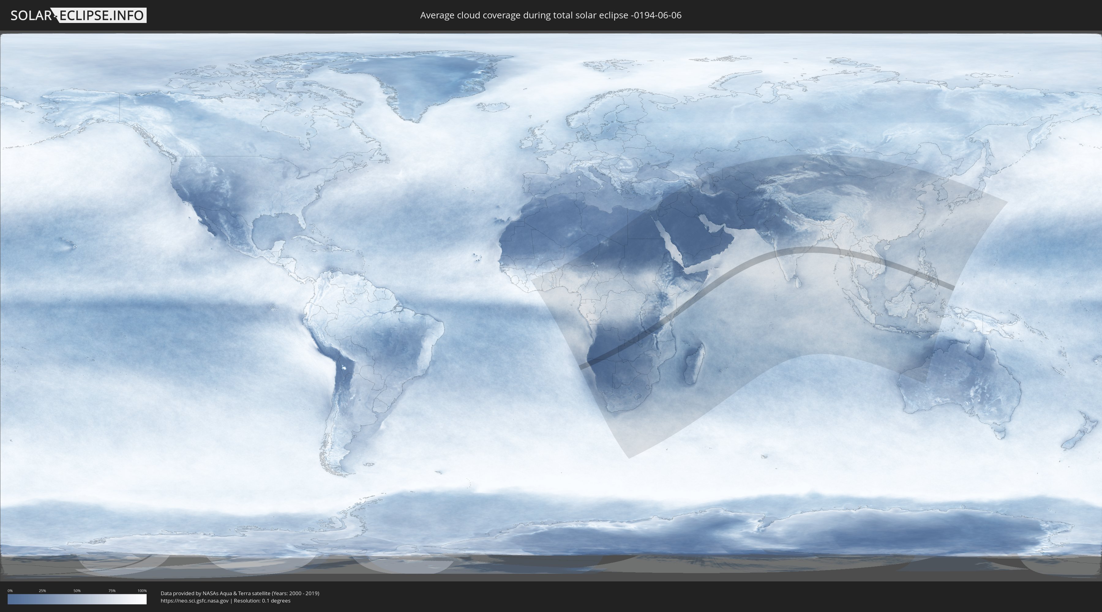
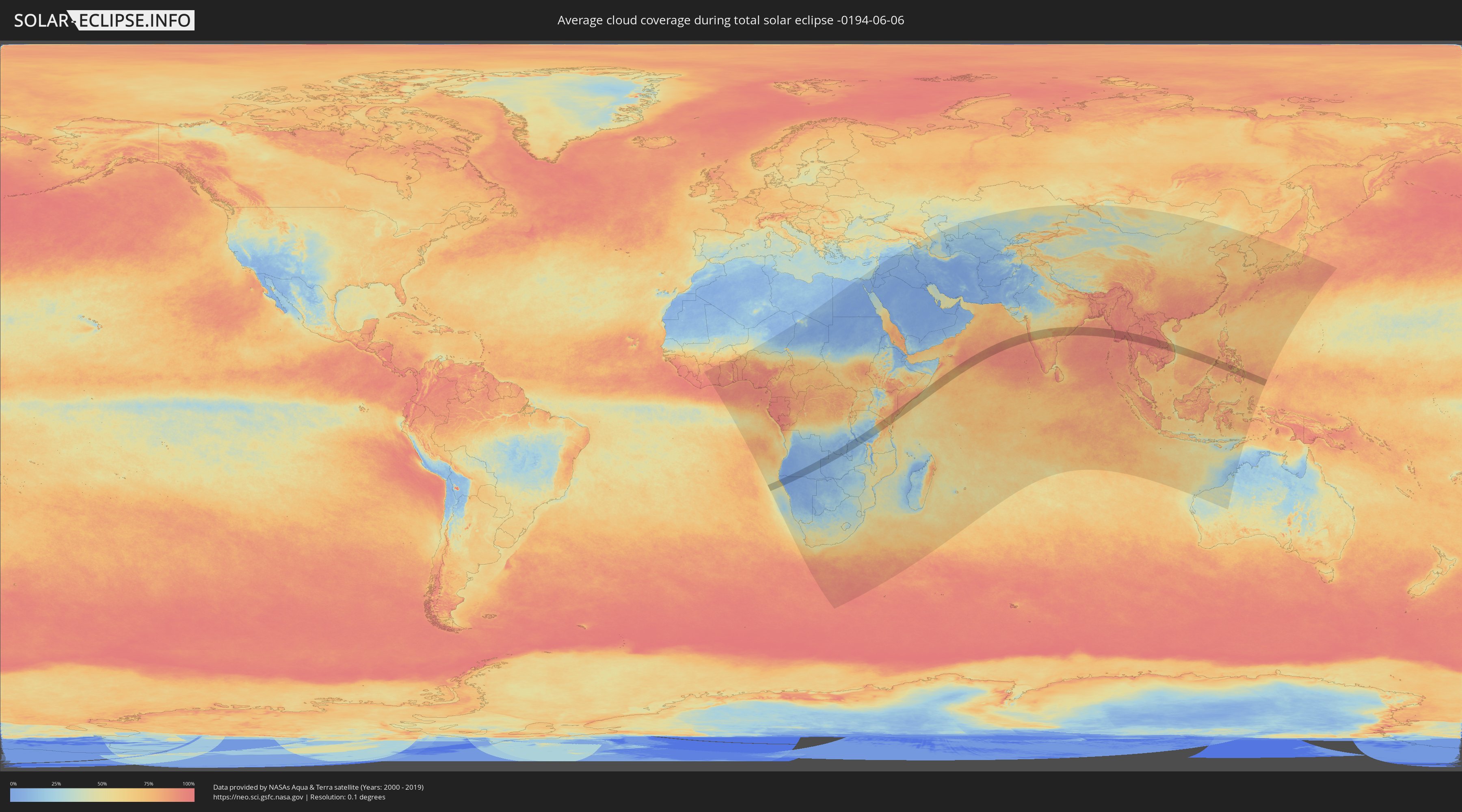
How will be the weather during the total solar eclipse on 06/06/-0194?
Where is the best place to see the total solar eclipse of 06/06/-0194?
The following maps show the average cloud coverage for the day of the total solar eclipse.
With the help of these maps, it is possible to find the place along the eclipse path, which has the best
chance of a cloudless sky.
Nevertheless, you should consider local circumstances and inform about the weather of your chosen
observation site.
The data is provided by NASAs satellites
AQUA and TERRA.
The cloud maps are averaged over a period of 19 years (2000 - 2019).
Detailed country maps
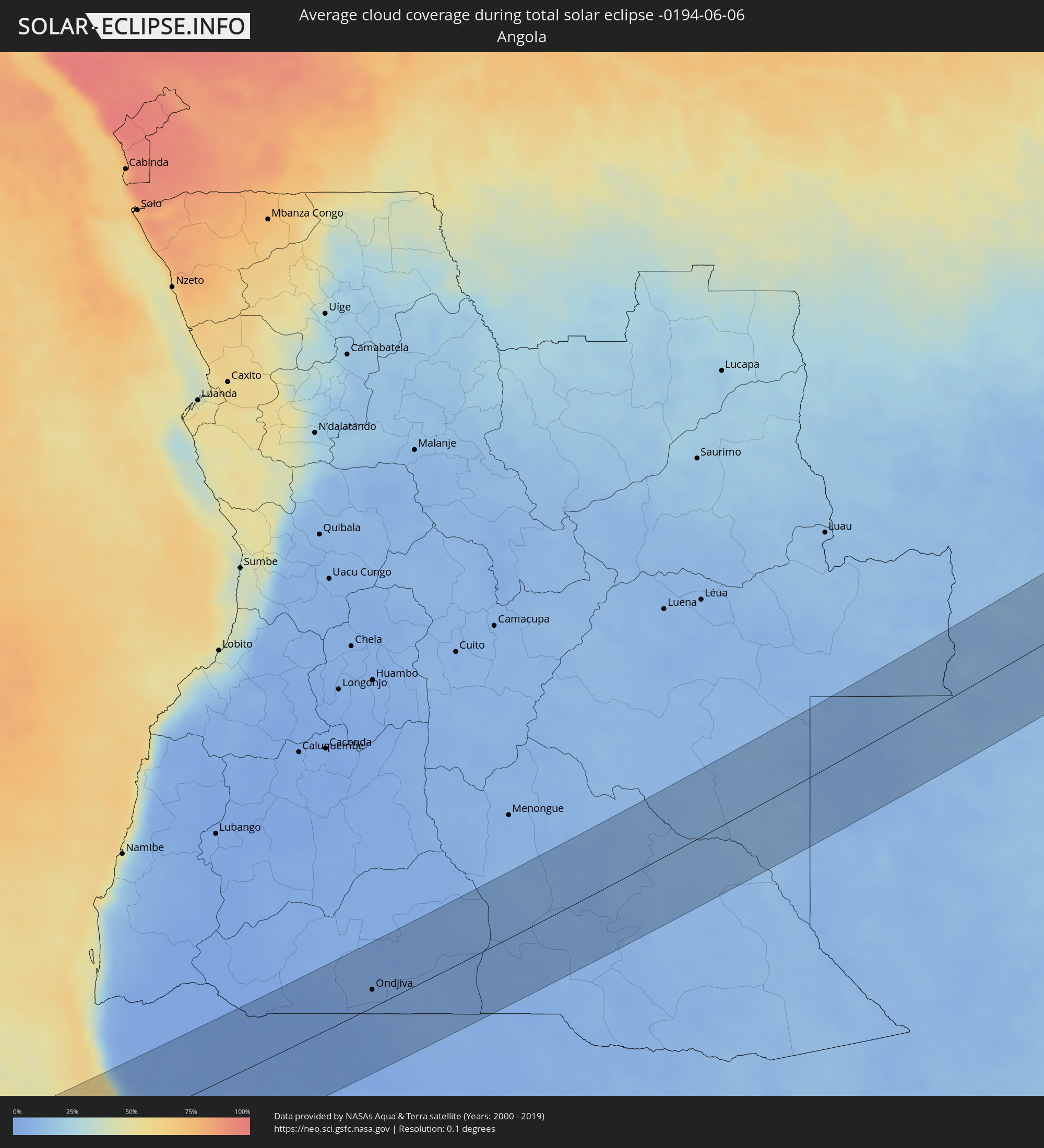 Angola
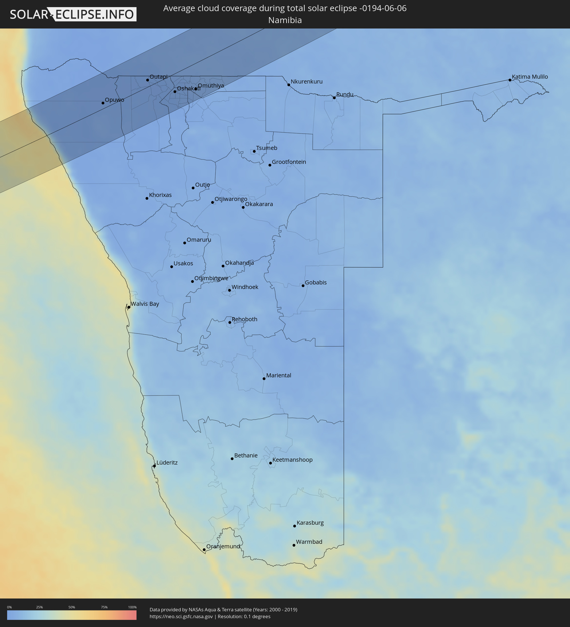 Namibia
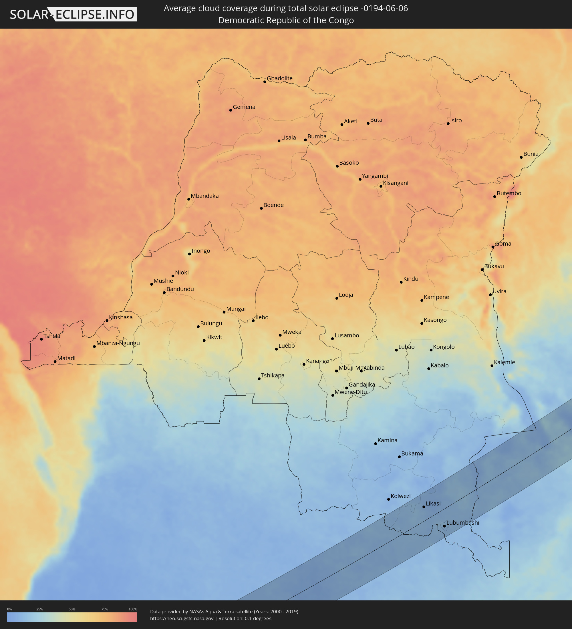 Democratic Republic of the Congo
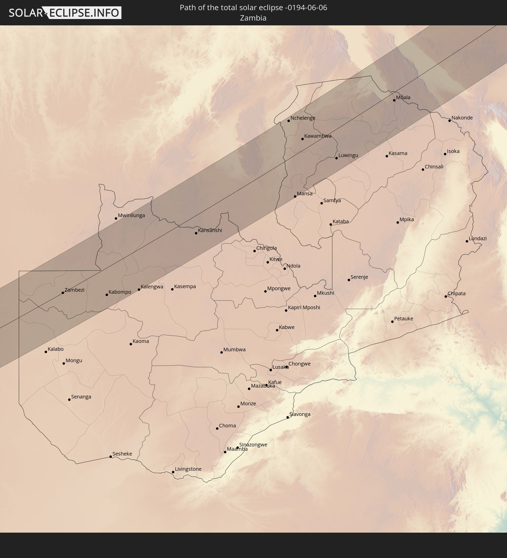
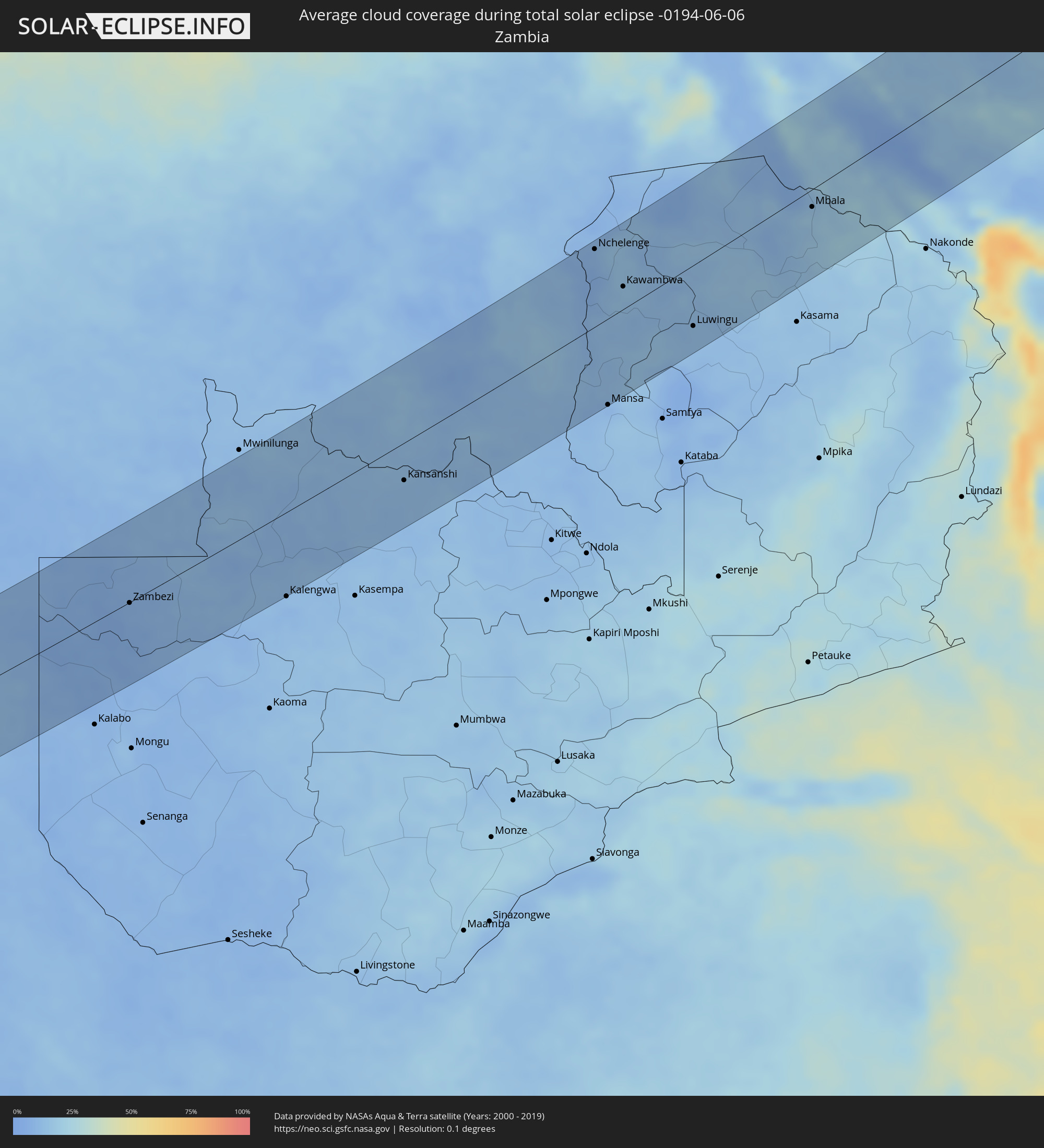 Zambia
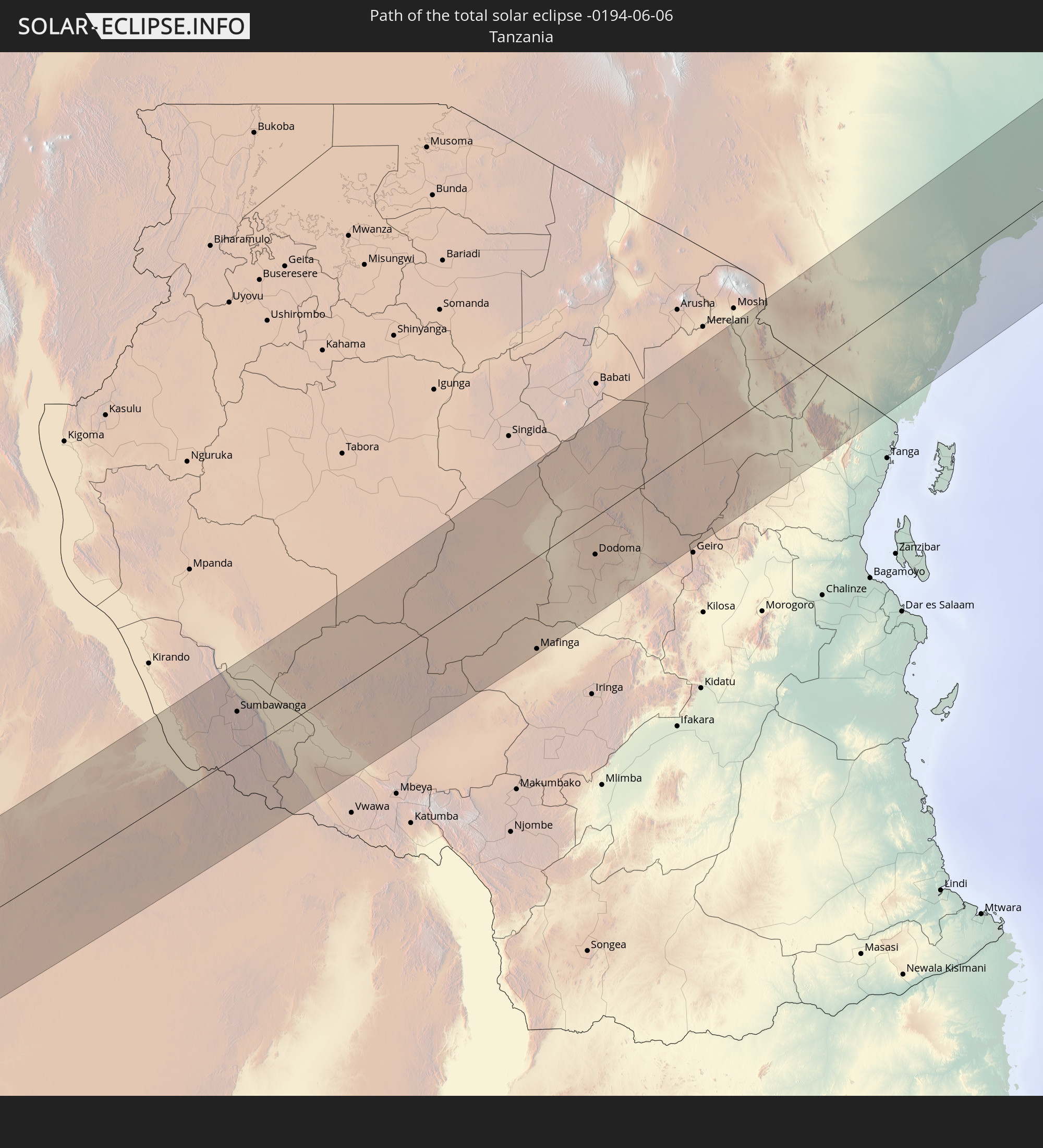
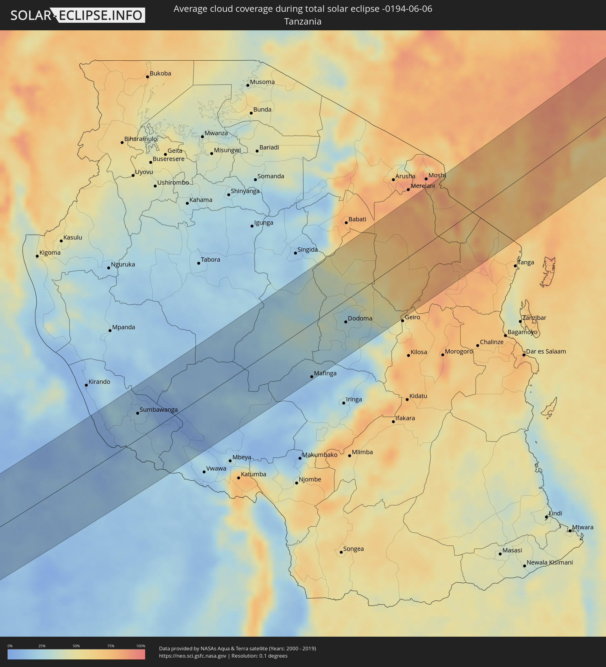 Tanzania
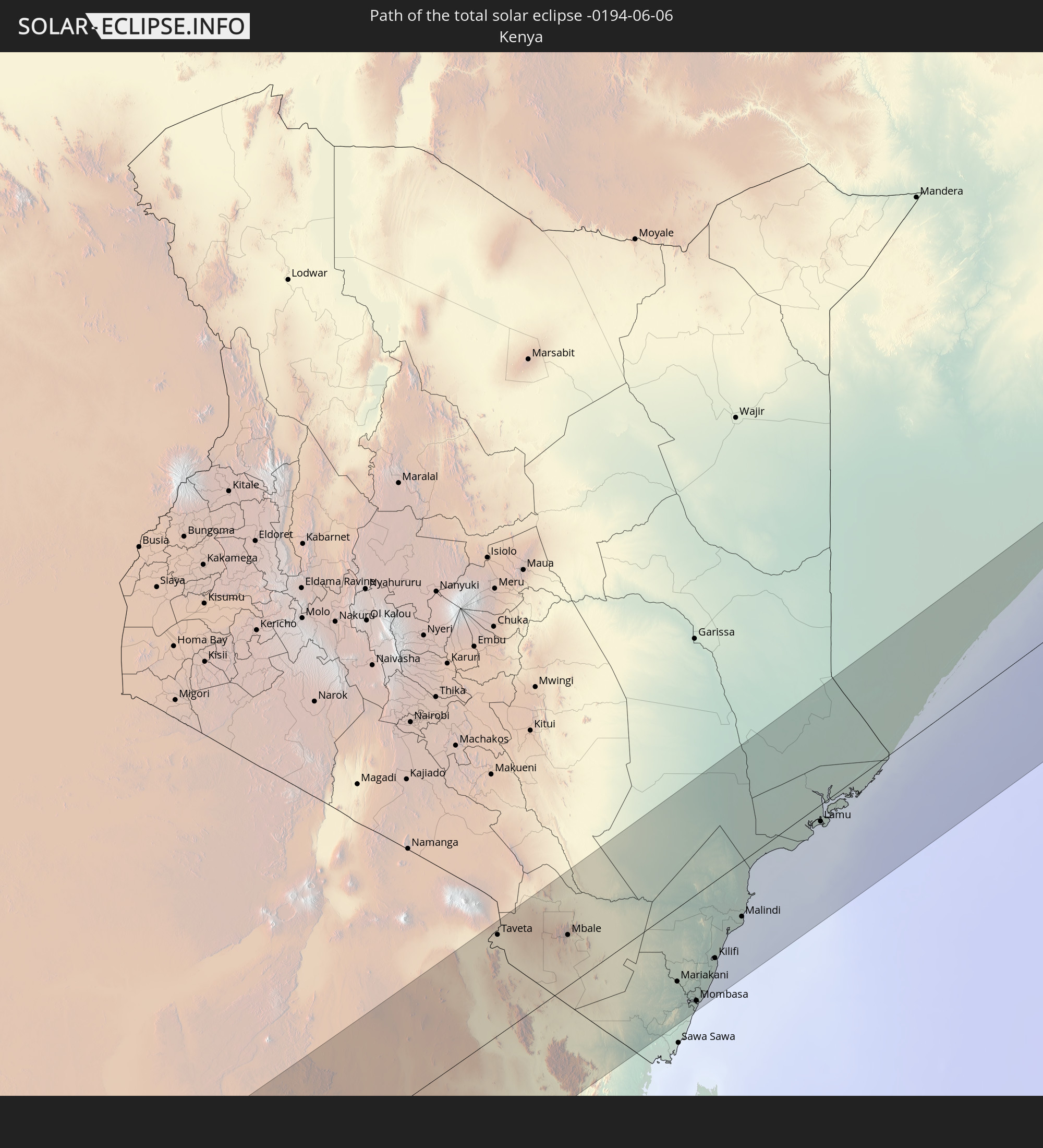
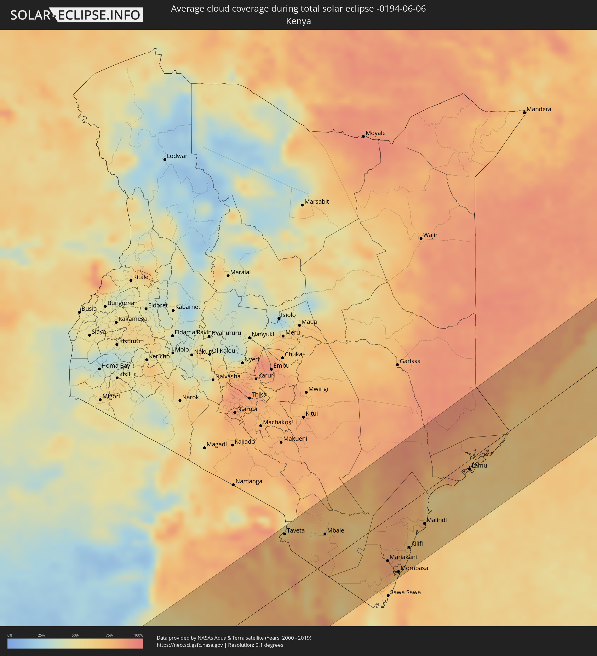 Kenya
Kenya
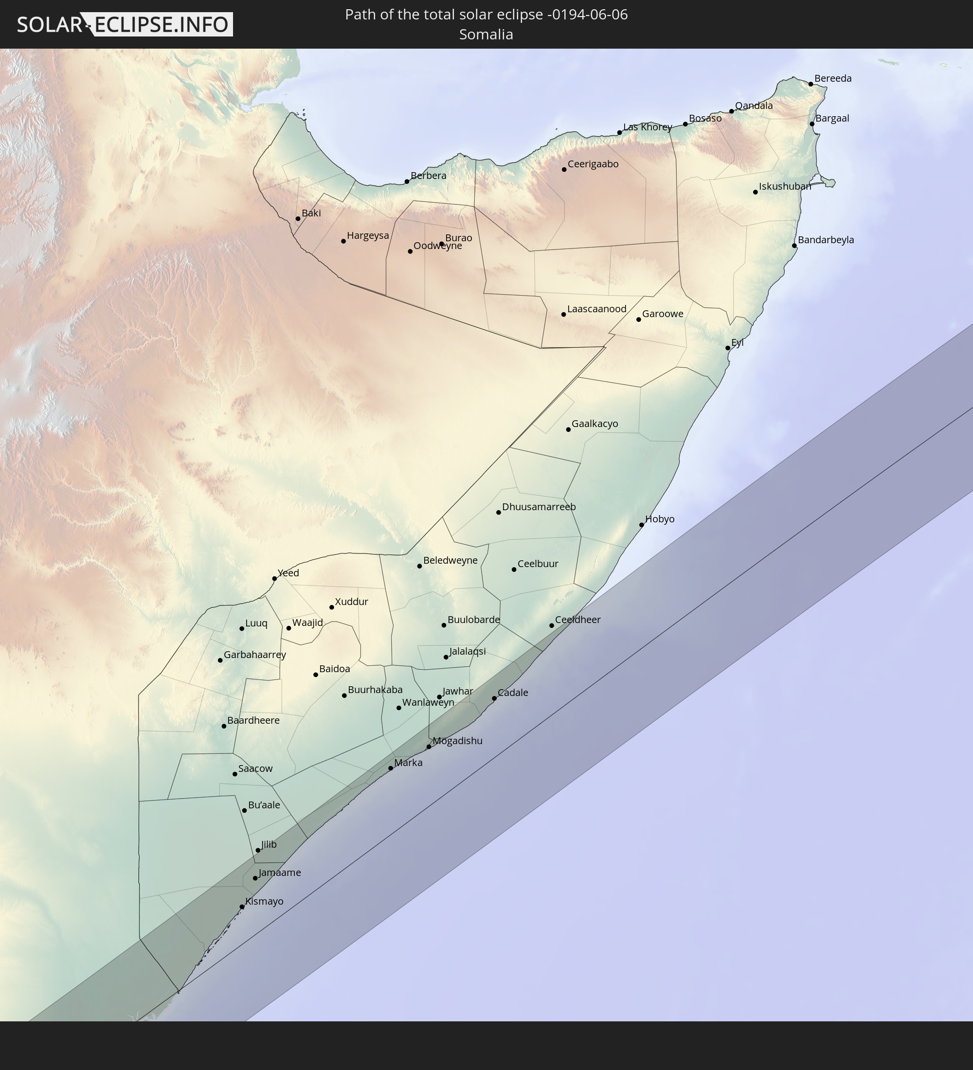
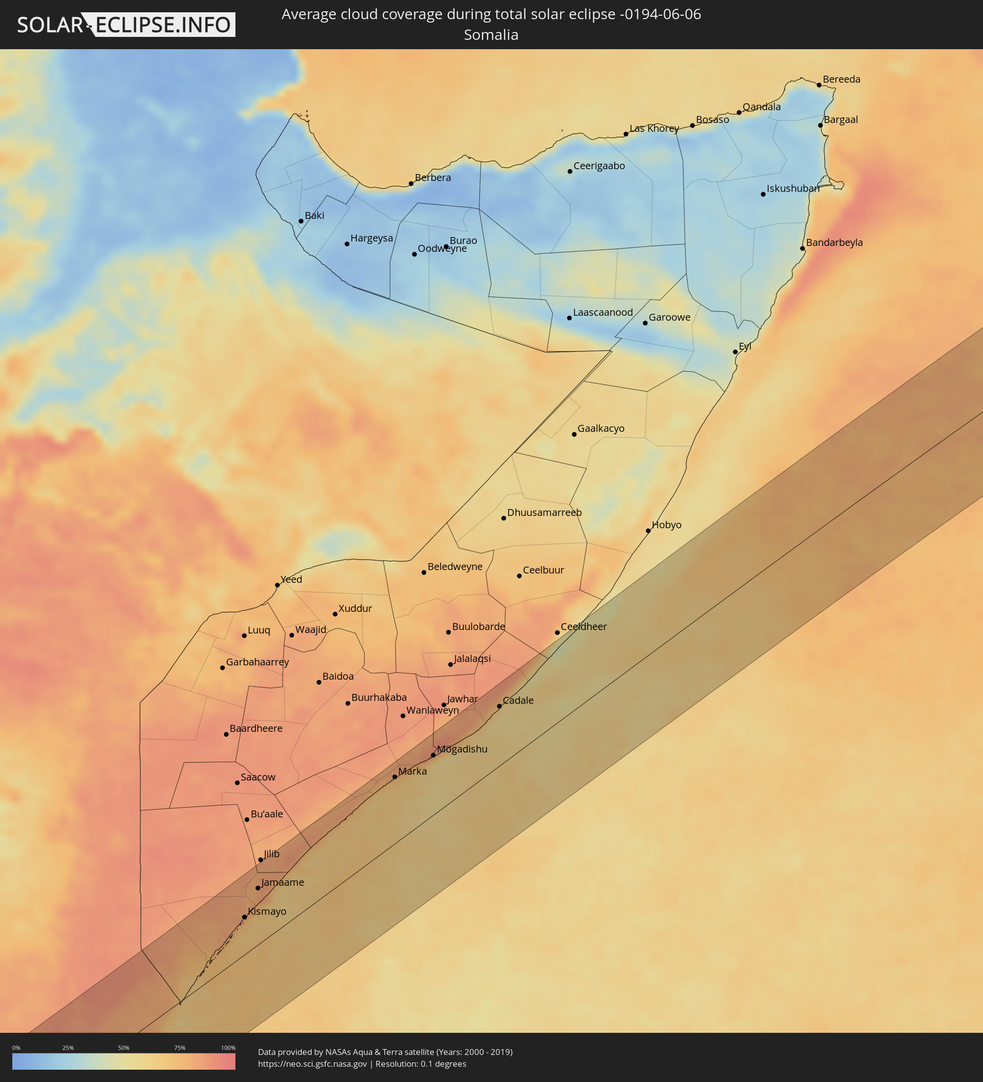 Somalia
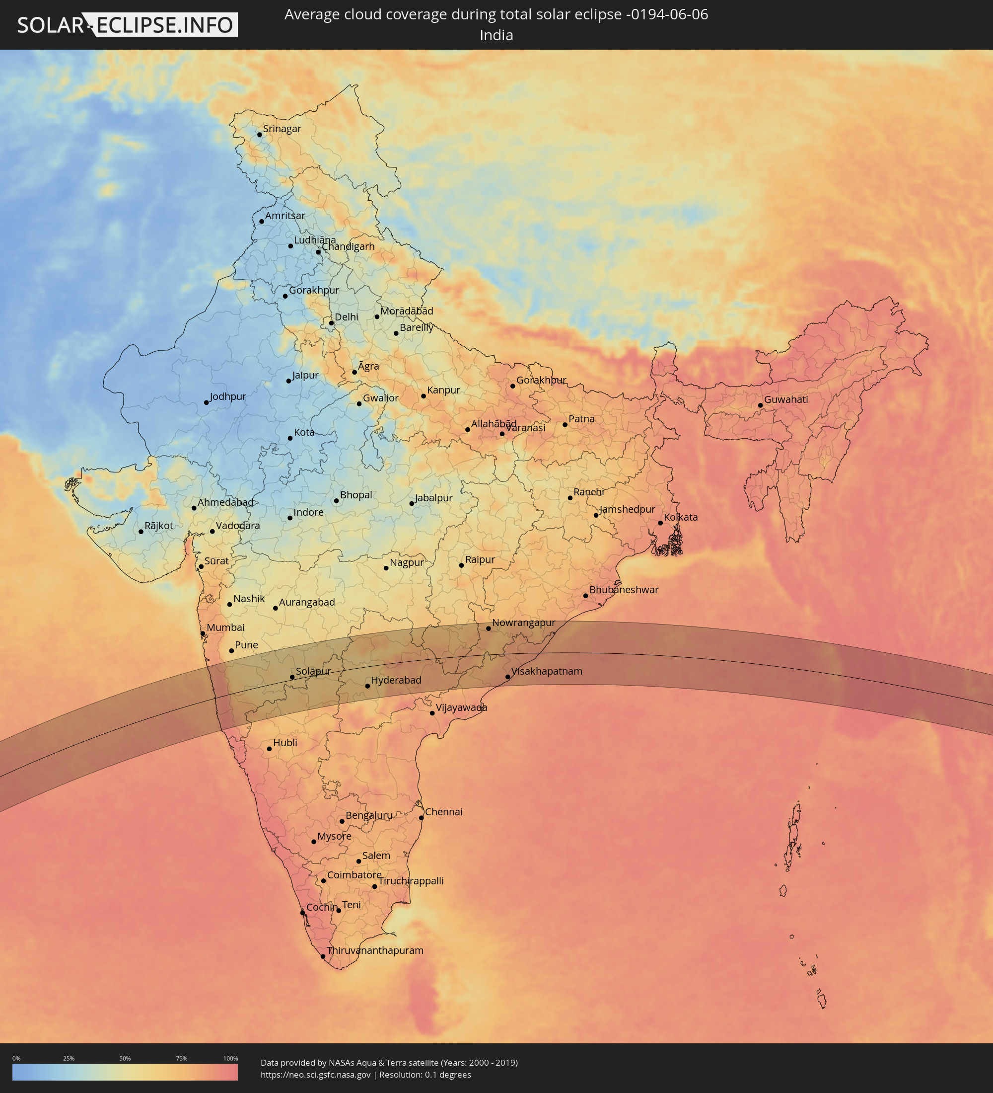 India
India
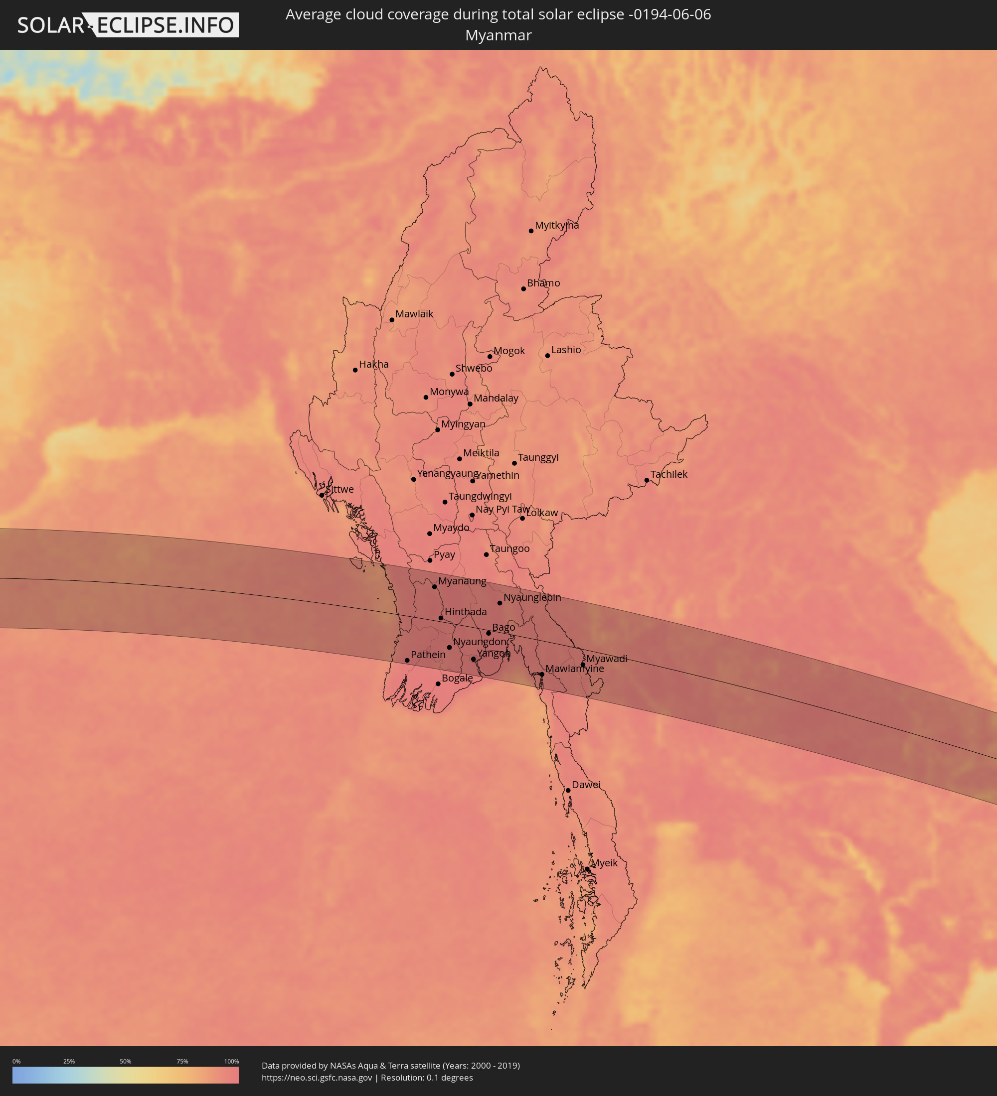 Myanmar
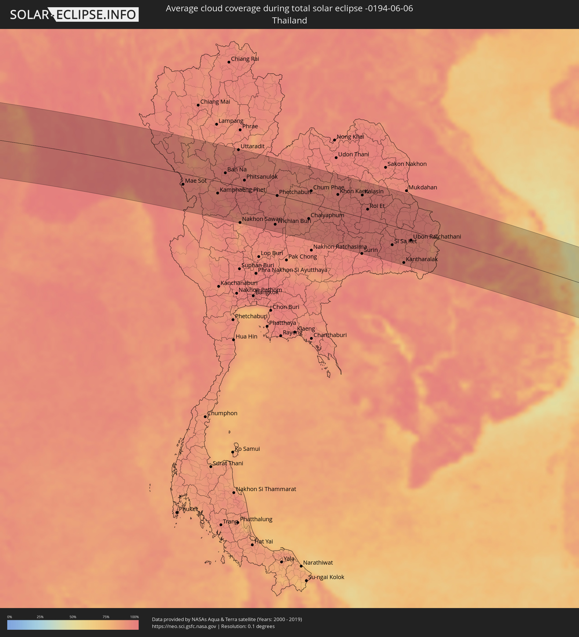 Thailand
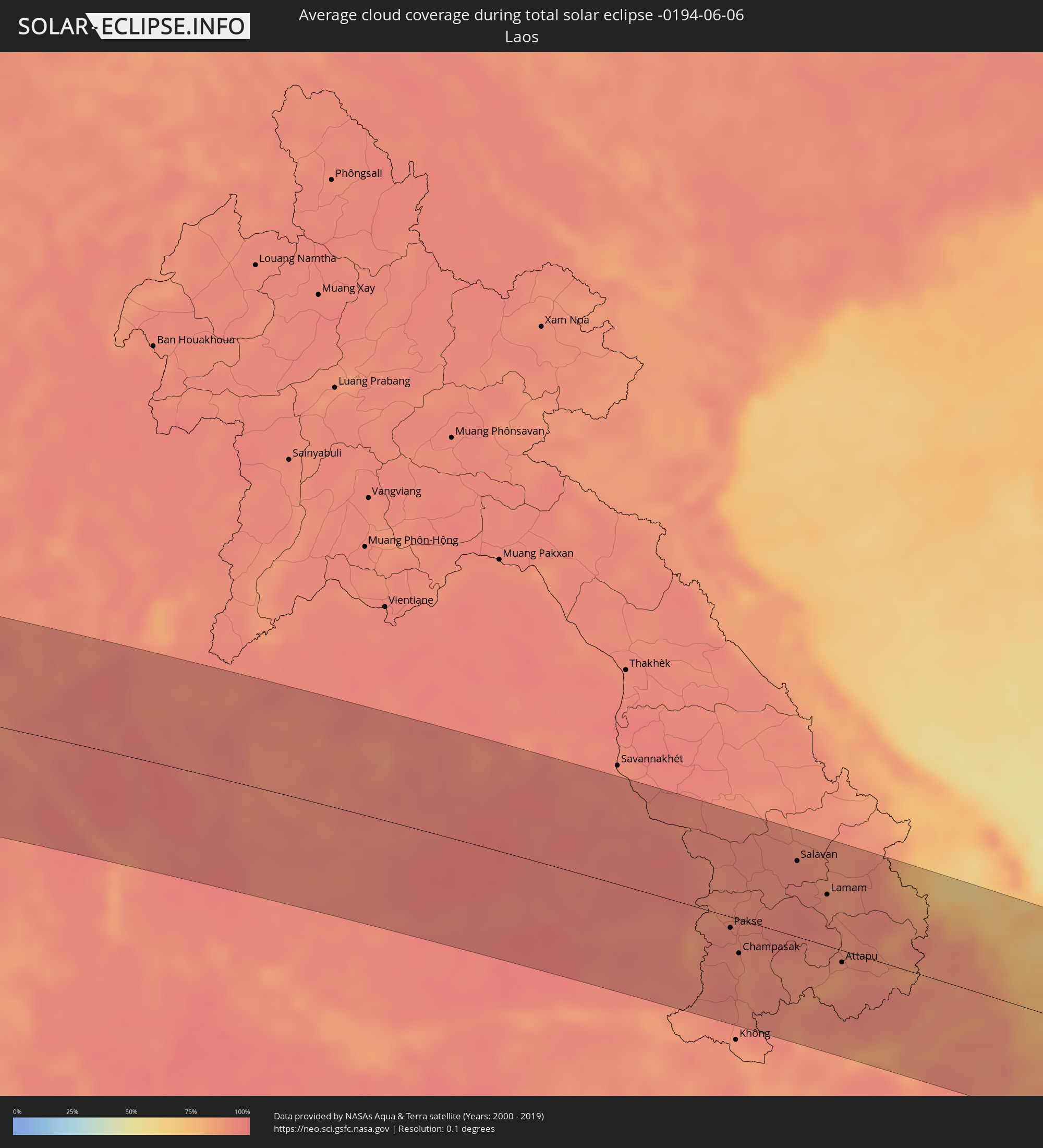 Laos
Laos
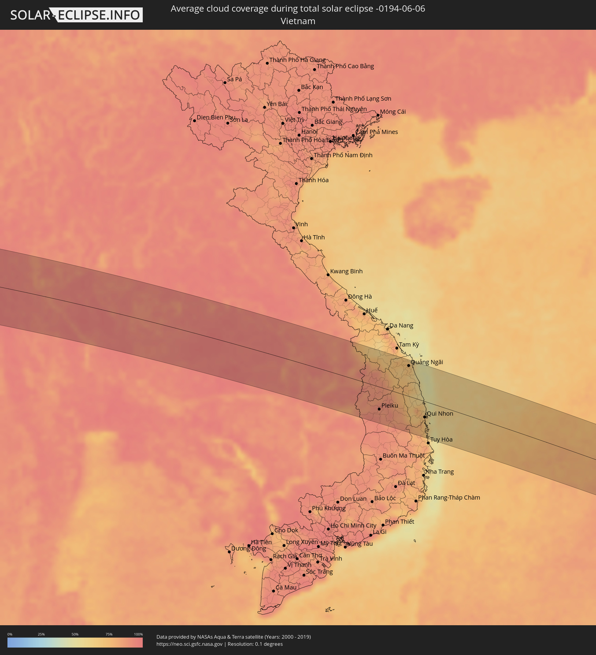 Vietnam
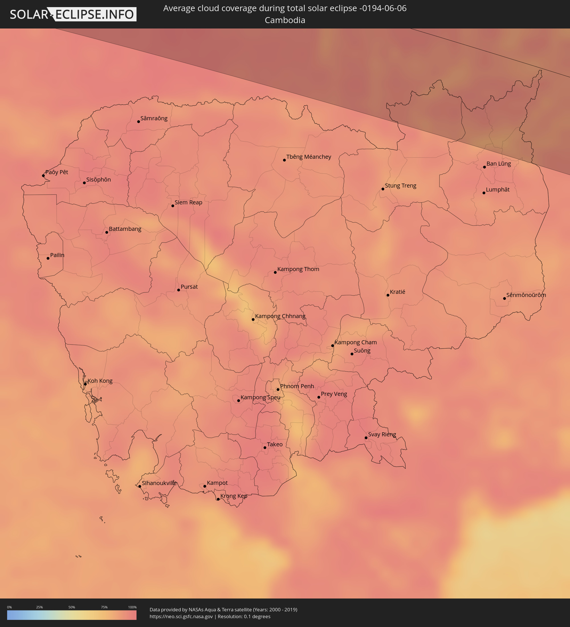 Cambodia
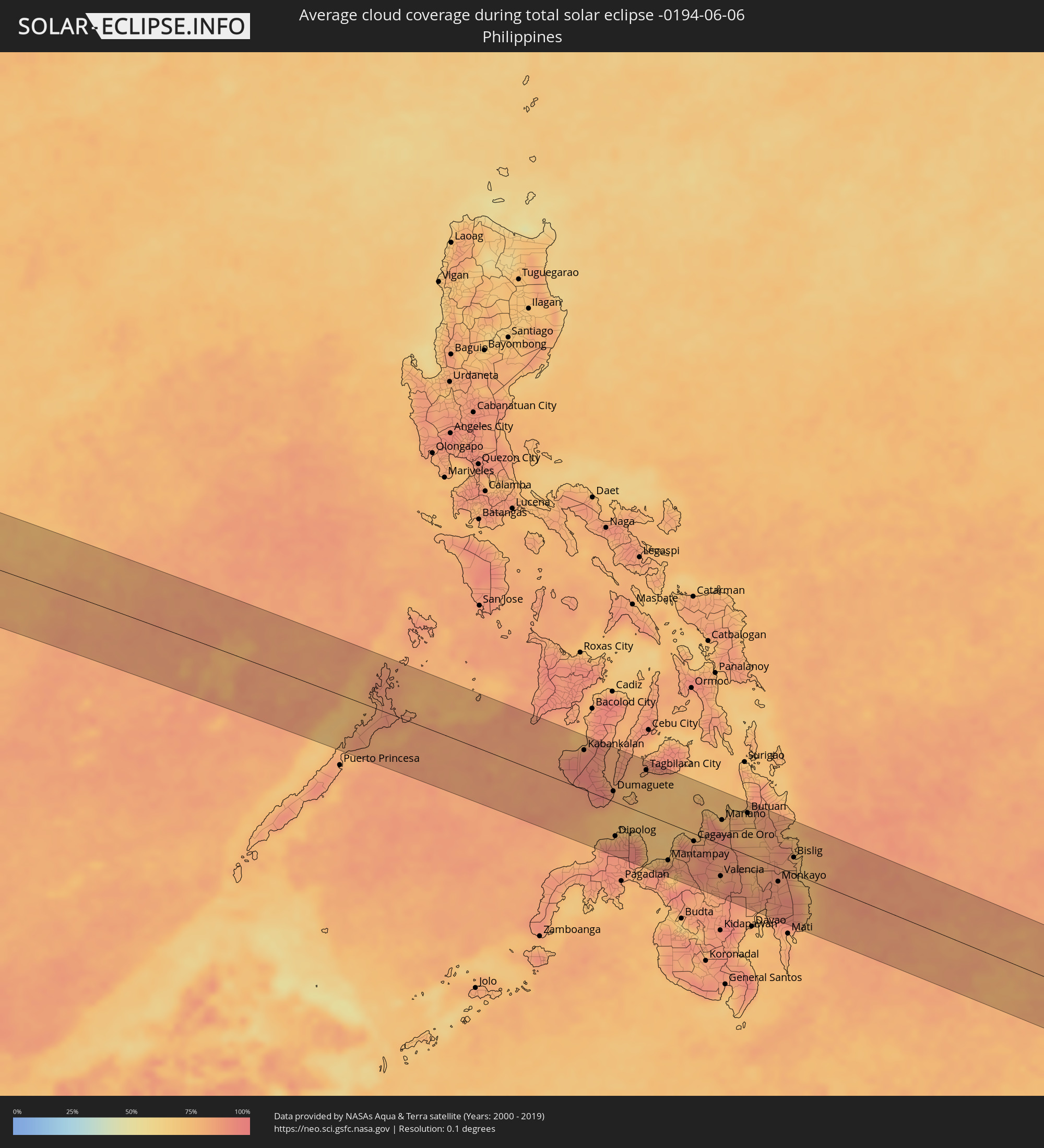 Philippines
Cities inside the path of the eclipse
The following table shows all locations with a population of more than 5,000 inside the eclipse path. Cities which have more than 100,000 inhabitants are marked bold. A click at the locations opens a detailed map.
| City | Type | Eclipse duration | Local time of max. eclipse | Distance to central line | Ø Cloud coverage |
|
Opuwo, Kunene
|
total | - | 07:20:44 UTC+01:30 | 13 km | 2% |
|
Outapi, Omusati
|
total | - | 07:20:57 UTC+01:30 | 16 km | 1% |
|
Oshakati, Oshana
|
total | - | 07:21:00 UTC+01:30 | 45 km | 2% |
|
Ondjiva, Cunene
|
total | - | 06:04:44 UTC+00:13 | 24 km | 4% |
|
Ongwediva, Oshana
|
total | - | 07:21:01 UTC+01:30 | 49 km | 2% |
|
Ondangwa, Oshana
|
total | - | 07:21:01 UTC+01:30 | 71 km | 2% |
|
Omuthiya, Oshikoto
|
total | - | 07:21:06 UTC+01:30 | 64 km | 4% |
|
Eenhana, Ohangwena
|
total | - | 07:21:10 UTC+01:30 | 44 km | 5% |
|
Zambezi, North-Western
|
total | - | 08:04:31 UTC+02:10 | 1 km | 7% |
|
Solwezi, North-Western
|
total | - | 08:06:37 UTC+02:10 | 47 km | 11% |
|
Kansanshi, North-Western
|
total | - | 08:06:40 UTC+02:10 | 43 km | 12% |
|
Kambove, Katanga
|
total | - | 08:07:22 UTC+02:10 | 65 km | 11% |
|
Likasi, Katanga
|
total | - | 08:07:23 UTC+02:10 | 46 km | 11% |
|
Kipushi, Katanga
|
total | - | 08:07:16 UTC+02:10 | 57 km | 12% |
|
Lubumbashi, Katanga
|
total | - | 08:07:27 UTC+02:10 | 60 km | 10% |
|
Nchelenge, Luapula
|
total | - | 08:09:29 UTC+02:10 | 88 km | 9% |
|
Mansa, Luapula
|
total | - | 08:08:31 UTC+02:10 | 97 km | 8% |
|
Kawambwa, Luapula
|
total | - | 08:09:26 UTC+02:10 | 26 km | 14% |
|
Luwingu, Northern
|
total | - | 08:09:43 UTC+02:10 | 68 km | 12% |
|
Mpulungu, Northern
|
total | - | 08:11:29 UTC+02:10 | 3 km | 11% |
|
Mbala, Northern
|
total | - | 08:11:37 UTC+02:10 | 20 km | 16% |
|
Matai, Rukwa
|
total | - | 08:29:01 UTC+02:27 | 22 km | 18% |
|
Sumbawanga, Rukwa
|
total | - | 08:29:19 UTC+02:27 | 47 km | 21% |
|
Laela, Rukwa
|
total | - | 08:29:14 UTC+02:27 | 35 km | 19% |
|
Mgandu, Singida
|
total | - | 08:32:54 UTC+02:27 | 81 km | 21% |
|
Itigi, Singida
|
total | - | 08:33:25 UTC+02:27 | 82 km | 23% |
|
Mafinga, Iringa
|
total | - | 08:32:43 UTC+02:27 | 97 km | 13% |
|
Dodoma, Dodoma
|
total | - | 08:34:12 UTC+02:27 | 40 km | 29% |
|
Kondoa, Dodoma
|
total | - | 08:35:19 UTC+02:27 | 74 km | 50% |
|
Mpwapwa, Dodoma
|
total | - | 08:34:46 UTC+02:27 | 102 km | 38% |
|
Naberera, Manyara
|
total | - | 08:37:05 UTC+02:27 | 66 km | 78% |
|
Lembeni, Kilimanjaro
|
total | - | 08:38:12 UTC+02:27 | 60 km | 77% |
|
Taveta
|
total | - | 08:38:38 UTC+02:27 | 91 km | 77% |
|
Same, Kilimanjaro
|
total | - | 08:38:03 UTC+02:27 | 27 km | 75% |
|
Hedaru, Kilimanjaro
|
total | - | 08:37:50 UTC+02:27 | 23 km | 74% |
|
Ndungu, Kilimanjaro
|
total | - | 08:38:07 UTC+02:27 | 21 km | 59% |
|
Makuyuni, Tanga
|
total | - | 08:37:50 UTC+02:27 | 57 km | 70% |
|
Lushoto, Tanga
|
total | - | 08:37:59 UTC+02:27 | 73 km | 82% |
|
Wundanyi, Taita Taveta
|
total | - | 08:39:22 UTC+02:27 | 47 km | 78% |
|
Mbale, Vihiga
|
total | - | 08:39:23 UTC+02:27 | 46 km | 78% |
|
Voi, Taita Taveta
|
total | - | 08:39:35 UTC+02:27 | 35 km | 78% |
|
Kinango, Kwale
|
total | - | 08:39:44 UTC+02:27 | 81 km | 72% |
|
Kwale, Kwale
|
total | - | 08:39:52 UTC+02:27 | 93 km | 74% |
|
Mariakani, Kwale
|
total | - | 08:40:11 UTC+02:27 | 66 km | 83% |
|
Mombasa, Mombasa
|
total | - | 08:40:13 UTC+02:27 | 96 km | 69% |
|
Kilifi, Kilifi
|
total | - | 08:40:51 UTC+02:27 | 70 km | 73% |
|
Takaungu, Kilifi
|
total | - | 08:40:48 UTC+02:27 | 75 km | 69% |
|
Malindi, Kilifi
|
total | - | 08:41:34 UTC+02:27 | 50 km | 72% |
|
Witu, Lamu
|
total | - | 08:42:48 UTC+02:27 | 4 km | 73% |
|
Lamu, Lamu
|
total | - | 08:43:29 UTC+02:27 | 15 km | 63% |
|
Kismayo, Lower Juba
|
total | - | 08:47:42 UTC+02:27 | 49 km | 70% |
|
Jamaame, Lower Juba
|
total | - | 08:48:28 UTC+02:27 | 74 km | 79% |
|
Marka, Lower Shabeelle
|
total | - | 08:53:20 UTC+02:27 | 87 km | 68% |
|
Afgooye, Lower Shabeelle
|
total | - | 08:54:23 UTC+02:27 | 102 km | 84% |
|
Mogadishu, Banaadir
|
total | - | 08:54:36 UTC+02:27 | 78 km | 67% |
|
Cadale, Middle Shabele
|
total | - | 08:57:03 UTC+02:27 | 78 km | 66% |
|
Kolhāpur, Maharashtra
|
total | - | 13:16:49 UTC+05:21 | 60 km | 80% |
|
Ichalkaranji, Maharashtra
|
total | - | 13:17:27 UTC+05:21 | 66 km | 79% |
|
Sāngli, Maharashtra
|
total | - | 13:17:53 UTC+05:21 | 51 km | 75% |
|
Bijapur, Karnataka
|
total | - | 13:21:04 UTC+05:21 | 81 km | 70% |
|
Solāpur, Maharashtra
|
total | - | 13:22:13 UTC+05:21 | 7 km | 65% |
|
Latur, Maharashtra
|
total | - | 13:24:30 UTC+05:21 | 73 km | 62% |
|
Gulbarga, Karnataka
|
total | - | 13:24:32 UTC+05:21 | 49 km | 68% |
|
Nizāmābād, Telangana
|
total | - | 13:28:44 UTC+05:21 | 76 km | 68% |
|
Hyderabad, Telangana
|
total | - | 13:28:58 UTC+05:21 | 71 km | 72% |
|
Secunderabad, Telangana
|
total | - | 13:29:16 UTC+05:21 | 60 km | 69% |
|
Karīmnagar, Telangana
|
total | - | 13:31:19 UTC+05:21 | 35 km | 75% |
|
Rāmgundam, Telangana
|
total | - | 13:32:21 UTC+05:21 | 71 km | 66% |
|
Warangal, Telangana
|
total | - | 13:32:18 UTC+05:21 | 19 km | 79% |
|
Nowrangapur, Odisha
|
total | - | 13:40:19 UTC+05:21 | 91 km | 79% |
|
Visakhapatnam, Andhra Pradesh
|
total | - | 13:41:28 UTC+05:21 | 85 km | 87% |
|
Brahmapur, Odisha
|
total | - | 13:45:43 UTC+05:21 | 93 km | 85% |
|
Pathein, Ayeyarwady
|
total | - | 15:10:02 UTC+06:24 | 101 km | 97% |
|
Hinthada, Ayeyarwady
|
total | - | 15:11:11 UTC+06:24 | 7 km | 96% |
|
Maubin, Ayeyarwady
|
total | - | 15:11:40 UTC+06:24 | 90 km | 97% |
|
Tharyarwady, Bago
|
total | - | 15:11:45 UTC+06:24 | 14 km | 98% |
|
Twante, Yangon
|
total | - | 15:12:09 UTC+06:24 | 87 km | 97% |
|
Kanbe, Yangon
|
total | - | 15:12:16 UTC+06:24 | 86 km | 98% |
|
Yangon, Yangon
|
total | - | 15:12:31 UTC+06:24 | 72 km | 98% |
|
Bago, Bago
|
total | - | 15:12:59 UTC+06:24 | 8 km | 98% |
|
Thongwa, Yangon
|
total | - | 15:13:09 UTC+06:24 | 70 km | 98% |
|
Nyaunglebin, Bago
|
total | - | 15:13:16 UTC+06:24 | 64 km | 97% |
|
Kyaikto, Mon
|
total | - | 15:13:52 UTC+06:24 | 0 km | 96% |
|
Thaton, Mon
|
total | - | 15:14:31 UTC+06:24 | 35 km | 96% |
|
Martaban, Mon
|
total | - | 15:14:59 UTC+06:24 | 73 km | 95% |
|
Mawlamyine, Mon
|
total | - | 15:15:01 UTC+06:24 | 77 km | 95% |
|
Hpa-an, Kayin
|
total | - | 15:14:57 UTC+06:24 | 33 km | 96% |
|
Mudon, Mon
|
total | - | 15:15:13 UTC+06:24 | 100 km | 95% |
|
Mae Sot, Tak
|
total | - | 15:33:44 UTC+06:42 | 31 km | 94% |
|
Kamphaeng Phet, Kamphaeng Phet
|
total | - | 15:35:14 UTC+06:42 | 35 km | 92% |
|
Ban Na, Sukhothai
|
total | - | 15:35:25 UTC+06:42 | 28 km | 95% |
|
Uttaradit, Uttaradit
|
total | - | 15:35:47 UTC+06:42 | 103 km | 96% |
|
Nakhon Sawan, Nakhon Sawan
|
total | - | 15:36:19 UTC+06:42 | 104 km | 86% |
|
Phitsanulok, Phitsanulok
|
total | - | 15:36:14 UTC+06:42 | 20 km | 96% |
|
Wichian Buri, Phetchabun
|
total | - | 15:37:42 UTC+06:42 | 85 km | 97% |
|
Phetchabun, Phetchabun
|
total | - | 15:37:36 UTC+06:42 | 1 km | 94% |
|
Chaiyaphum, Chaiyaphum
|
total | - | 15:38:56 UTC+06:42 | 44 km | 94% |
|
Chum Phae, Khon Kaen
|
total | - | 15:38:50 UTC+06:42 | 37 km | 91% |
|
Khon Kaen, Khon Kaen
|
total | - | 15:39:48 UTC+06:42 | 46 km | 94% |
|
Maha Sarakham, Maha Sarakham
|
total | - | 15:40:28 UTC+06:42 | 31 km | 96% |
|
Kalasin, Kalasin
|
total | - | 15:40:39 UTC+06:42 | 63 km | 95% |
|
Roi Et, Roi Et
|
total | - | 15:40:56 UTC+06:42 | 27 km | 96% |
|
Si Sa Ket, Sisaket
|
total | - | 15:42:01 UTC+06:42 | 55 km | 96% |
|
Ubon Ratchathani, Changwat Ubon Ratchathani
|
total | - | 15:42:36 UTC+06:42 | 26 km | 94% |
|
Pakse, Champasak
|
total | - | 15:43:42 UTC+06:42 | 10 km | 92% |
|
Champasak, Champasak
|
total | - | 15:43:51 UTC+06:42 | 32 km | 88% |
|
Salavan, Salavan
|
total | - | 15:44:12 UTC+06:42 | 72 km | 92% |
|
Lamam, Xékong
|
total | - | 15:44:35 UTC+06:42 | 49 km | 89% |
|
Attapu, Attapu
|
total | - | 15:44:54 UTC+06:42 | 12 km | 85% |
|
Pleiku, Gia Lai
|
total | - | 16:10:55 UTC+07:06 | 62 km | 89% |
|
Kon Tum, Kon Tum
|
total | - | 16:10:50 UTC+07:06 | 23 km | 86% |
|
Quảng Ngãi, Quảng Ngãi
|
total | - | 16:11:22 UTC+07:06 | 84 km | 70% |
|
Sông Cầu, Phú Yên
|
total | - | 16:12:14 UTC+07:06 | 78 km | 73% |
|
Qui Nhon, Bình Định
|
total | - | 16:12:09 UTC+07:06 | 44 km | 71% |
|
Kabankalan, Western Visayas
|
total | - | 17:14:23 UTC+08:00 | 67 km | 92% |
|
Bais, Central Visayas
|
total | - | 17:14:32 UTC+08:00 | 39 km | 85% |
|
Dumaguete, Central Visayas
|
total | - | 17:14:38 UTC+08:00 | 17 km | 80% |
|
Dipolog, Zamboanga Peninsula
|
total | - | 17:14:46 UTC+08:00 | 58 km | 79% |
|
Ozamiz City, Northern Mindanao
|
total | - | 17:14:57 UTC+08:00 | 81 km | 78% |
|
Tagbilaran City, Central Visayas
|
total | - | 17:14:43 UTC+08:00 | 76 km | 81% |
|
Mantampay, Northern Mindanao
|
total | - | 17:15:03 UTC+08:00 | 63 km | 79% |
|
Marawi City, Autonomous Region in Muslim Mindanao
|
total | - | 17:15:05 UTC+08:00 | 78 km | 74% |
|
Iligan City, Soccsksargen
|
total | - | 17:15:04 UTC+08:00 | 47 km | 83% |
|
Cagayan de Oro, Northern Mindanao
|
total | - | 17:15:06 UTC+08:00 | 13 km | 86% |
|
Valencia, Northern Mindanao
|
total | - | 17:15:16 UTC+08:00 | 54 km | 81% |
|
Mariano, Northern Mindanao
|
total | - | 17:15:08 UTC+08:00 | 42 km | 80% |
|
Malaybalay, Northern Mindanao
|
total | - | 17:15:14 UTC+08:00 | 27 km | 85% |
|
Butuan, Caraga
|
total | - | 17:15:12 UTC+08:00 | 72 km | 78% |
|
Tagum, Davao
|
total | - | 17:15:27 UTC+08:00 | 72 km | 77% |
|
Bislig, Caraga
|
total | - | 17:15:27 UTC+08:00 | 28 km | 80% |