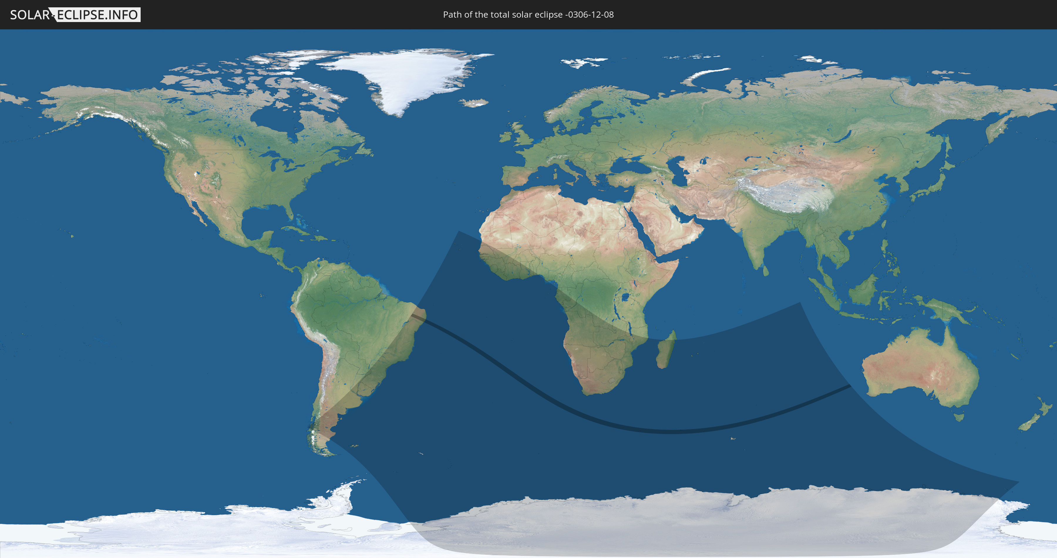
Total solar eclipse of 12/08/-0306
| Day of week: | Monday |
| Maximum duration of eclipse: | 03m31s |
| Maximum width of eclipse path: | 161 km |
| Saros cycle: | 66 |
| Coverage: | 100% |
| Magnitude: | 1.0452 |
| Gamma: | -0.3559 |
Wo kann man die Sonnenfinsternis vom 12/08/-0306 sehen?
Die Sonnenfinsternis am 12/08/-0306 kann man in 46 Ländern als partielle Sonnenfinsternis beobachten.
Der Finsternispfad verläuft durch 2 Länder. Nur in diesen Ländern ist sie als total Sonnenfinsternis zu sehen.
In den folgenden Ländern ist die Sonnenfinsternis total zu sehen
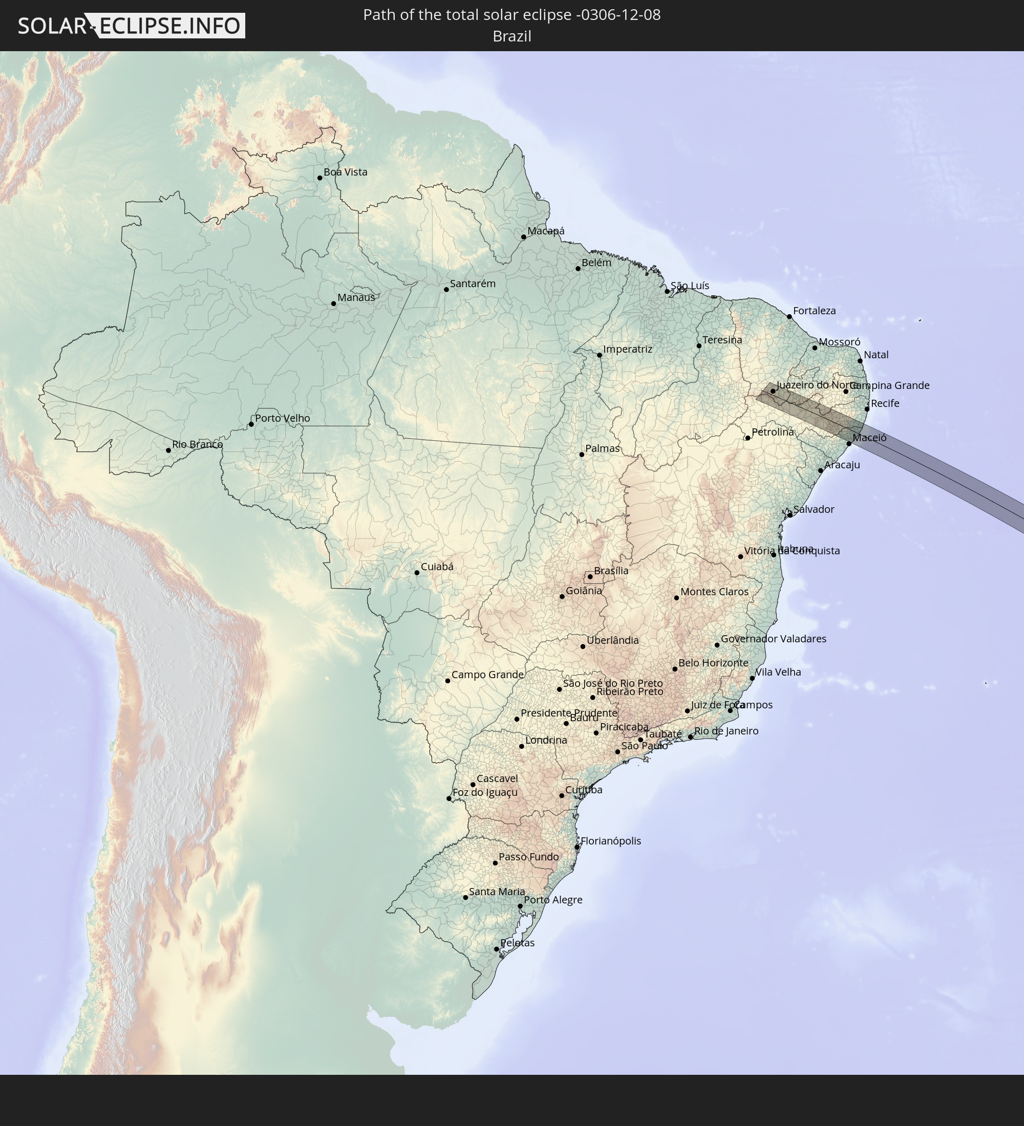 Brazil
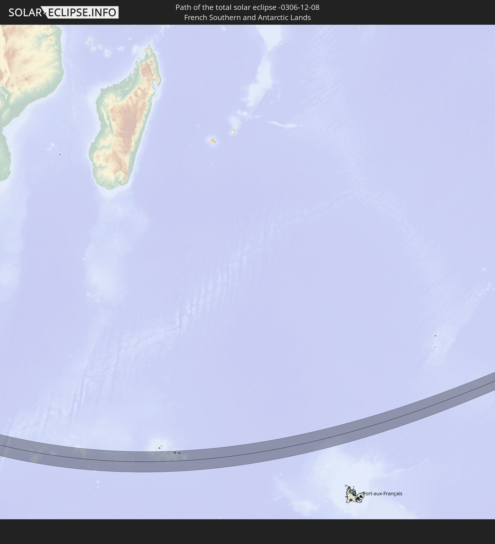 French Southern and Antarctic Lands
In den folgenden Ländern ist die Sonnenfinsternis partiell zu sehen
 Antarctica
 Chile
Chile
 Brazil
 Argentina
 Paraguay
 Falkland Islands
 Uruguay
 South Georgia and the South Sandwich Islands
 Cabo Verde
 Senegal
 Mauritania
 The Gambia
 Guinea-Bissau
 Guinea
 Saint Helena, Ascension and Tristan da Cunha
 Sierra Leone
 Mali
Mali
 Liberia
 Ivory Coast
 Burkina Faso
 Ghana
Ghana
 Togo
Togo
 Benin
Benin
 Nigeria
 Bouvet Island
 Equatorial Guinea
 São Tomé and Príncipe
 Gabon
Gabon
 Republic of the Congo
 Angola
 Namibia
 Democratic Republic of the Congo
 South Africa
 Botswana
 Zambia
 Zimbabwe
 Lesotho
 Mozambique
 Swaziland
 Malawi
 French Southern and Antarctic Lands
 Madagascar
 Réunion
 Mauritius
 Heard Island and McDonald Islands
 Cocos Islands
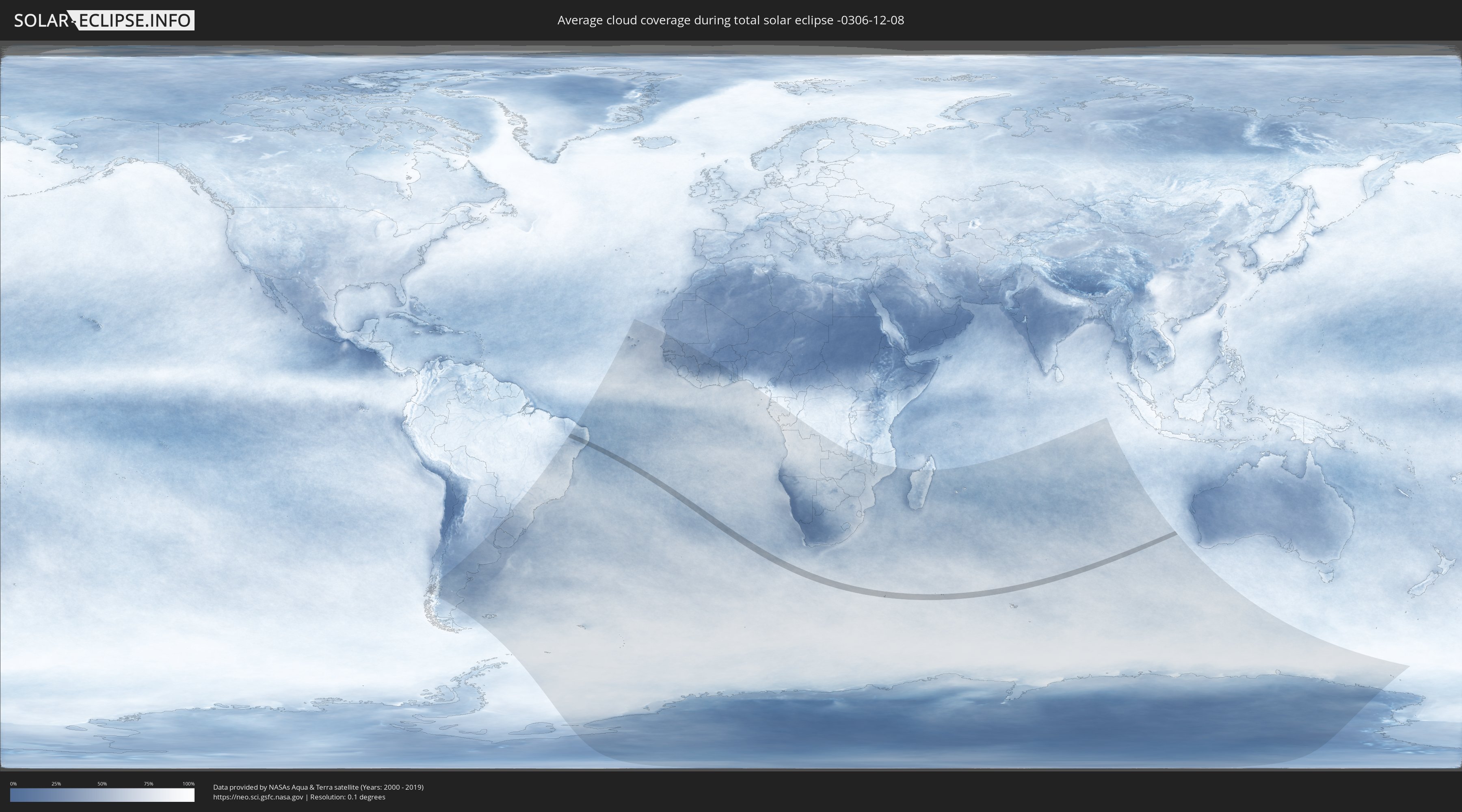
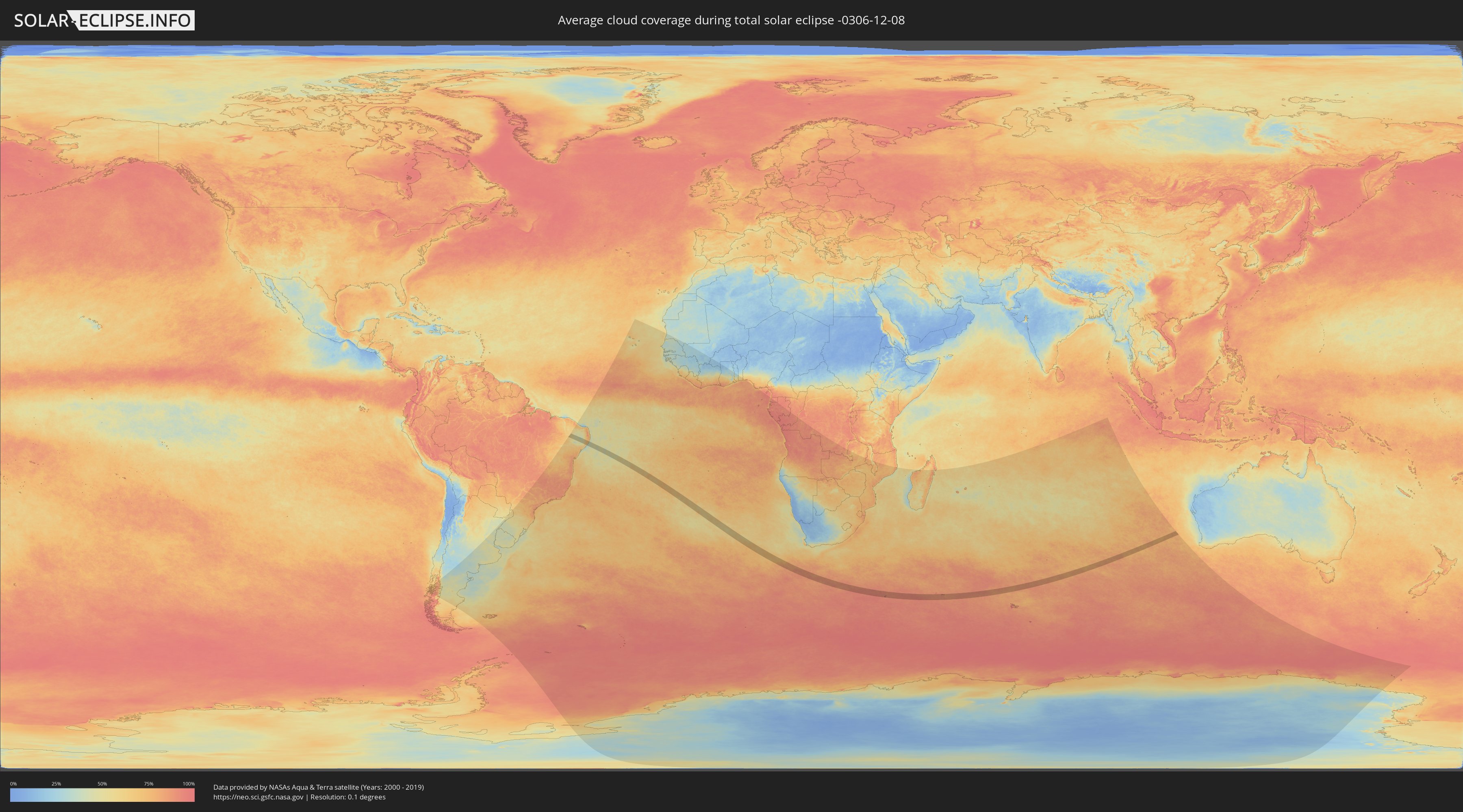
How will be the weather during the total solar eclipse on 12/08/-0306?
Where is the best place to see the total solar eclipse of 12/08/-0306?
The following maps show the average cloud coverage for the day of the total solar eclipse.
With the help of these maps, it is possible to find the place along the eclipse path, which has the best
chance of a cloudless sky.
Nevertheless, you should consider local circumstances and inform about the weather of your chosen
observation site.
The data is provided by NASAs satellites
AQUA and TERRA.
The cloud maps are averaged over a period of 19 years (2000 - 2019).
Detailed country maps
 Brazil
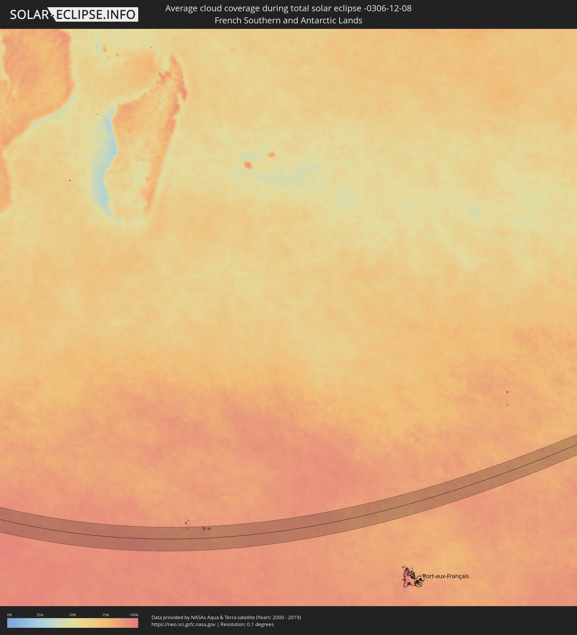 French Southern and Antarctic Lands
Cities inside the path of the eclipse
The following table shows all locations with a population of more than 5,000 inside the eclipse path. Cities which have more than 100,000 inhabitants are marked bold. A click at the locations opens a detailed map.
| City | Type | Eclipse duration | Local time of max. eclipse | Distance to central line | Ø Cloud coverage |
|
Exu, Pernambuco
|
total | - | 06:04:01 UTC-02:19 | 31 km | 58% |
|
Farias Brito, Ceará
|
total | - | 05:49:07 UTC-02:34 | 36 km | 59% |
|
Crato, Ceará
|
total | - | 05:49:18 UTC-02:34 | 13 km | 50% |
|
Juazeiro do Norte, Ceará
|
total | - | 05:49:16 UTC-02:34 | 18 km | 55% |
|
Barbalha, Ceará
|
total | - | 05:49:20 UTC-02:34 | 8 km | 53% |
|
Caririaçu, Ceará
|
total | - | 05:49:07 UTC-02:34 | 36 km | 57% |
|
Missão Velha, Ceará
|
total | - | 05:49:14 UTC-02:34 | 21 km | 56% |
|
Brejo Santo, Ceará
|
total | - | 05:49:23 UTC-02:34 | 3 km | 51% |
|
Milagres, Ceará
|
total | - | 05:49:14 UTC-02:34 | 23 km | 51% |
|
São José do Belmonte, Pernambuco
|
total | - | 06:04:00 UTC-02:19 | 24 km | 46% |
|
Serra Talhada, Pernambuco
|
total | - | 06:03:58 UTC-02:19 | 17 km | 47% |
|
Princesa Isabel, Paraíba
|
total | - | 05:49:17 UTC-02:34 | 22 km | 48% |
|
Flores, Pernambuco
|
total | - | 06:03:47 UTC-02:19 | 10 km | 48% |
|
Ibimirim, Pernambuco
|
total | - | 06:04:15 UTC-02:19 | 46 km | 48% |
|
Custódia, Pernambuco
|
total | - | 06:03:52 UTC-02:19 | 2 km | 48% |
|
Afogados da Ingazeira, Pernambuco
|
total | - | 06:03:36 UTC-02:19 | 37 km | 43% |
|
Tupanatinga, Pernambuco
|
total | - | 06:04:20 UTC-02:19 | 52 km | 47% |
|
Sertânia, Pernambuco
|
total | - | 06:03:46 UTC-02:19 | 21 km | 48% |
|
Buíque, Pernambuco
|
total | - | 06:04:11 UTC-02:19 | 30 km | 45% |
|
Monteiro, Paraíba
|
total | - | 05:49:11 UTC-02:34 | 46 km | 39% |
|
Arcoverde, Pernambuco
|
total | - | 06:03:59 UTC-02:19 | 5 km | 44% |
|
Pedra, Pernambuco
|
total | - | 06:04:01 UTC-02:19 | 8 km | 44% |
|
Pesqueira, Pernambuco
|
total | - | 06:03:51 UTC-02:19 | 18 km | 45% |
|
Caetés, Pernambuco
|
total | - | 06:04:10 UTC-02:19 | 21 km | 44% |
|
Garanhuns, Pernambuco
|
total | - | 06:04:14 UTC-02:19 | 27 km | 51% |
|
Belo Jardim, Pernambuco
|
total | - | 06:03:46 UTC-02:19 | 32 km | 52% |
|
Brejo da Madre de Deus, Pernambuco
|
total | - | 06:03:36 UTC-02:19 | 54 km | 52% |
|
São João, Pernambuco
|
total | - | 06:04:12 UTC-02:19 | 20 km | 53% |
|
Lajedo, Pernambuco
|
total | - | 06:04:01 UTC-02:19 | 4 km | 56% |
|
Cachoeirinha, Pernambuco
|
total | - | 06:03:51 UTC-02:19 | 26 km | 55% |
|
Santana do Mundaú, Alagoas
|
total | - | 05:50:01 UTC-02:34 | 43 km | 61% |
|
Canhotinho, Pernambuco
|
total | - | 06:04:10 UTC-02:19 | 12 km | 57% |
|
Altinho, Pernambuco
|
total | - | 06:03:49 UTC-02:19 | 33 km | 59% |
|
São José da Laje, Alagoas
|
total | - | 05:49:51 UTC-02:34 | 19 km | 64% |
|
União dos Palmares, Alagoas
|
total | - | 05:49:58 UTC-02:34 | 33 km | 65% |
|
Quipapá, Pernambuco
|
total | - | 06:04:05 UTC-02:19 | 1 km | 61% |
|
Cupira, Pernambuco
|
total | - | 06:03:53 UTC-02:19 | 26 km | 61% |
|
Agrestina, Pernambuco
|
total | - | 06:03:45 UTC-02:19 | 42 km | 63% |
|
Murici, Alagoas
|
total | - | 05:50:04 UTC-02:34 | 44 km | 69% |
|
Ibateguara, Alagoas
|
total | - | 05:49:47 UTC-02:34 | 10 km | 65% |
|
Rio Largo, Alagoas
|
total | - | 05:50:12 UTC-02:34 | 57 km | 61% |
|
Messias, Alagoas
|
total | - | 05:50:07 UTC-02:34 | 47 km | 66% |
|
Maraial, Pernambuco
|
total | - | 06:04:00 UTC-02:19 | 15 km | 68% |
|
São Joaquim do Monte, Pernambuco
|
total | - | 06:03:42 UTC-02:19 | 51 km | 63% |
|
Flexeiras, Alagoas
|
total | - | 05:49:57 UTC-02:34 | 25 km | 70% |
|
Bonito, Pernambuco
|
total | - | 06:03:43 UTC-02:19 | 51 km | 65% |
|
Colônia Leopoldina, Alagoas
|
total | - | 05:49:41 UTC-02:34 | 7 km | 73% |
|
Catende, Pernambuco
|
total | - | 06:03:53 UTC-02:19 | 31 km | 69% |
|
Novo Lino, Alagoas
|
total | - | 05:49:40 UTC-02:34 | 10 km | 72% |
|
Palmares, Pernambuco
|
total | - | 06:03:52 UTC-02:19 | 35 km | 71% |
|
São Luís do Quitunde, Alagoas
|
total | - | 05:50:00 UTC-02:34 | 27 km | 60% |
|
Joaquim Nabuco, Pernambuco
|
total | - | 06:03:48 UTC-02:19 | 44 km | 72% |
|
Matriz de Camaragibe, Alagoas
|
total | - | 05:49:51 UTC-02:34 | 9 km | 60% |
|
Água Preta, Pernambuco
|
total | - | 06:03:52 UTC-02:19 | 36 km | 74% |
|
Barra de Santo Antônio, Alagoas
|
total | - | 05:50:04 UTC-02:34 | 33 km | 41% |
|
Porto Calvo, Alagoas
|
total | - | 05:49:44 UTC-02:34 | 8 km | 66% |
|
Gameleira, Pernambuco
|
total | - | 06:03:44 UTC-02:19 | 55 km | 74% |
|
Maragogi, Alagoas
|
total | - | 05:49:40 UTC-02:34 | 20 km | 46% |
|
Barreiros, Pernambuco
|
total | - | 06:03:54 UTC-02:19 | 41 km | 60% |
|
Rio Formoso, Pernambuco
|
total | - | 06:03:46 UTC-02:19 | 57 km | 64% |
|
São José da Coroa Grande, Pernambuco
|
total | - | 06:03:57 UTC-02:19 | 35 km | 44% |
|
Tamandaré, Pernambuco
|
total | - | 06:03:50 UTC-02:19 | 51 km | 47% |