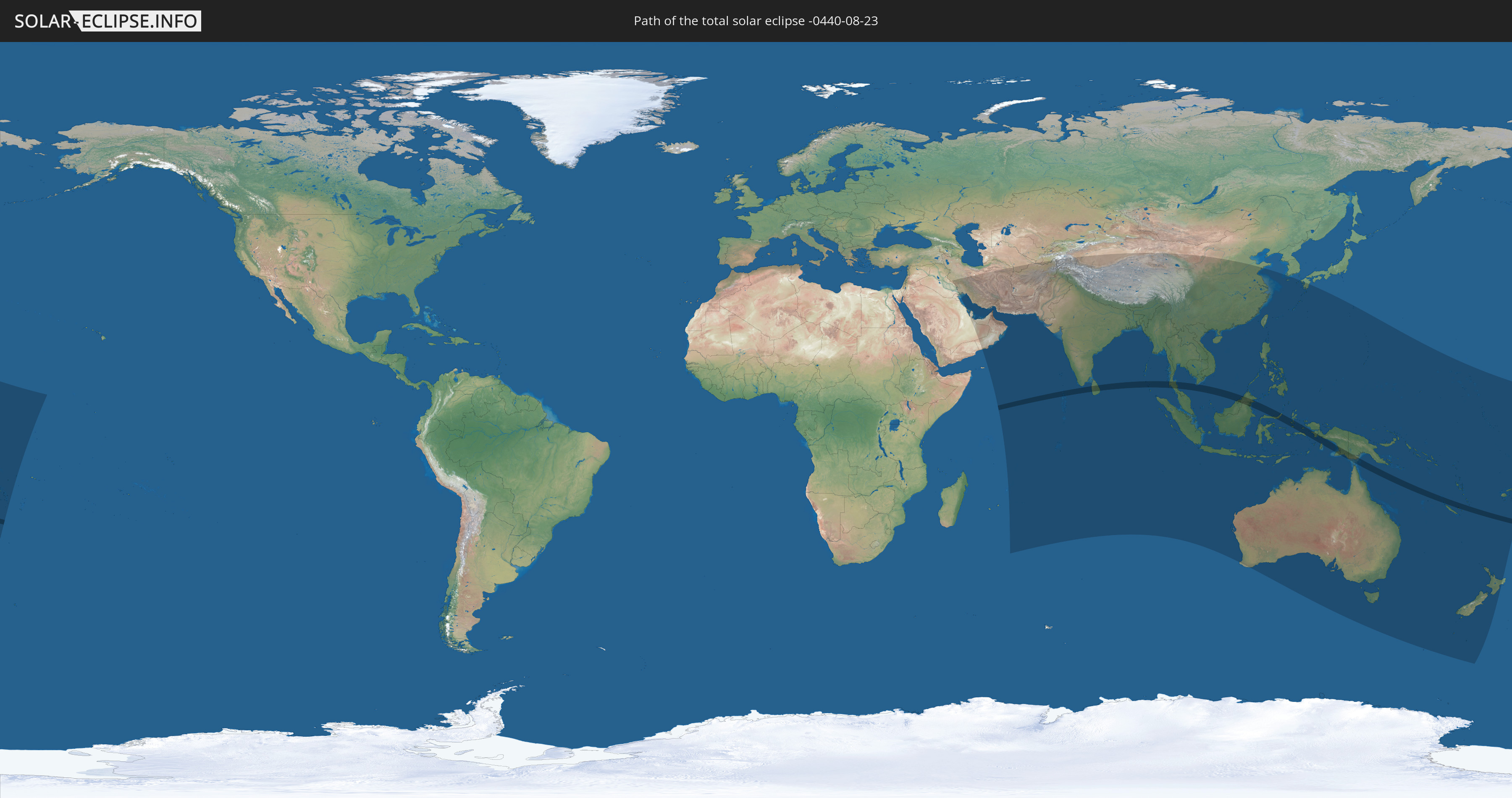
Total solar eclipse of 08/23/-0440
| Day of week: | Monday |
| Maximum duration of eclipse: | 04m59s |
| Maximum width of eclipse path: | 176 km |
| Saros cycle: | 57 |
| Coverage: | 100% |
| Magnitude: | 1.0523 |
| Gamma: | -0.1895 |
Wo kann man die Sonnenfinsternis vom 08/23/-0440 sehen?
Die Sonnenfinsternis am 08/23/-0440 kann man in 57 Ländern als partielle Sonnenfinsternis beobachten.
Der Finsternispfad verläuft durch 11 Länder. Nur in diesen Ländern ist sie als total Sonnenfinsternis zu sehen.
In den folgenden Ländern ist die Sonnenfinsternis total zu sehen
 India
India
 Maldives
 Sri Lanka
 Myanmar
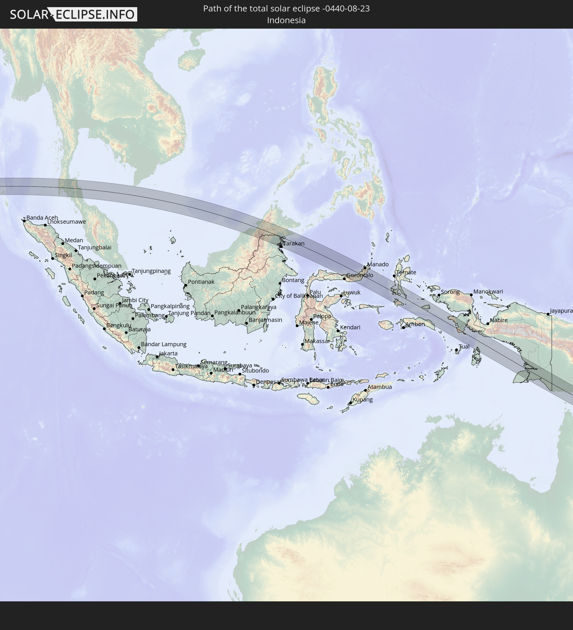 Indonesia
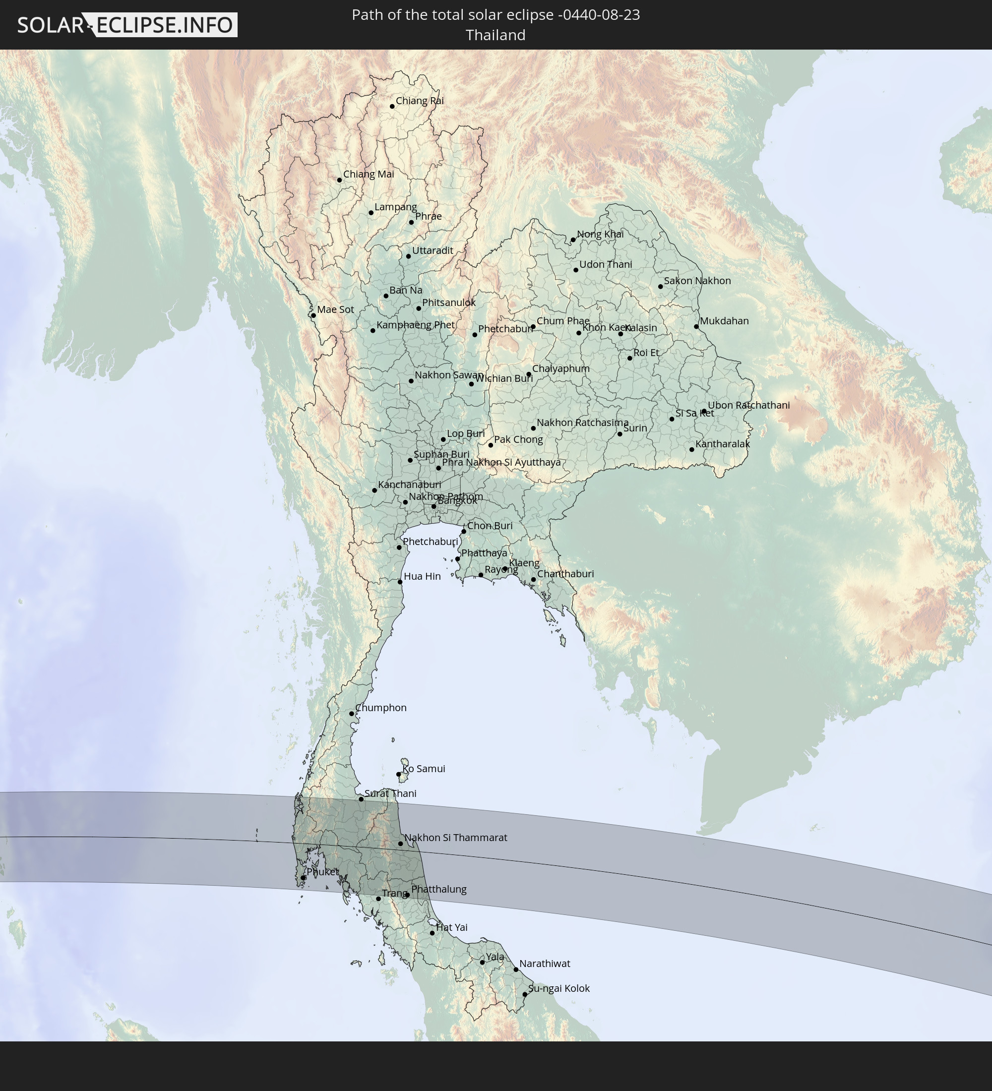 Thailand
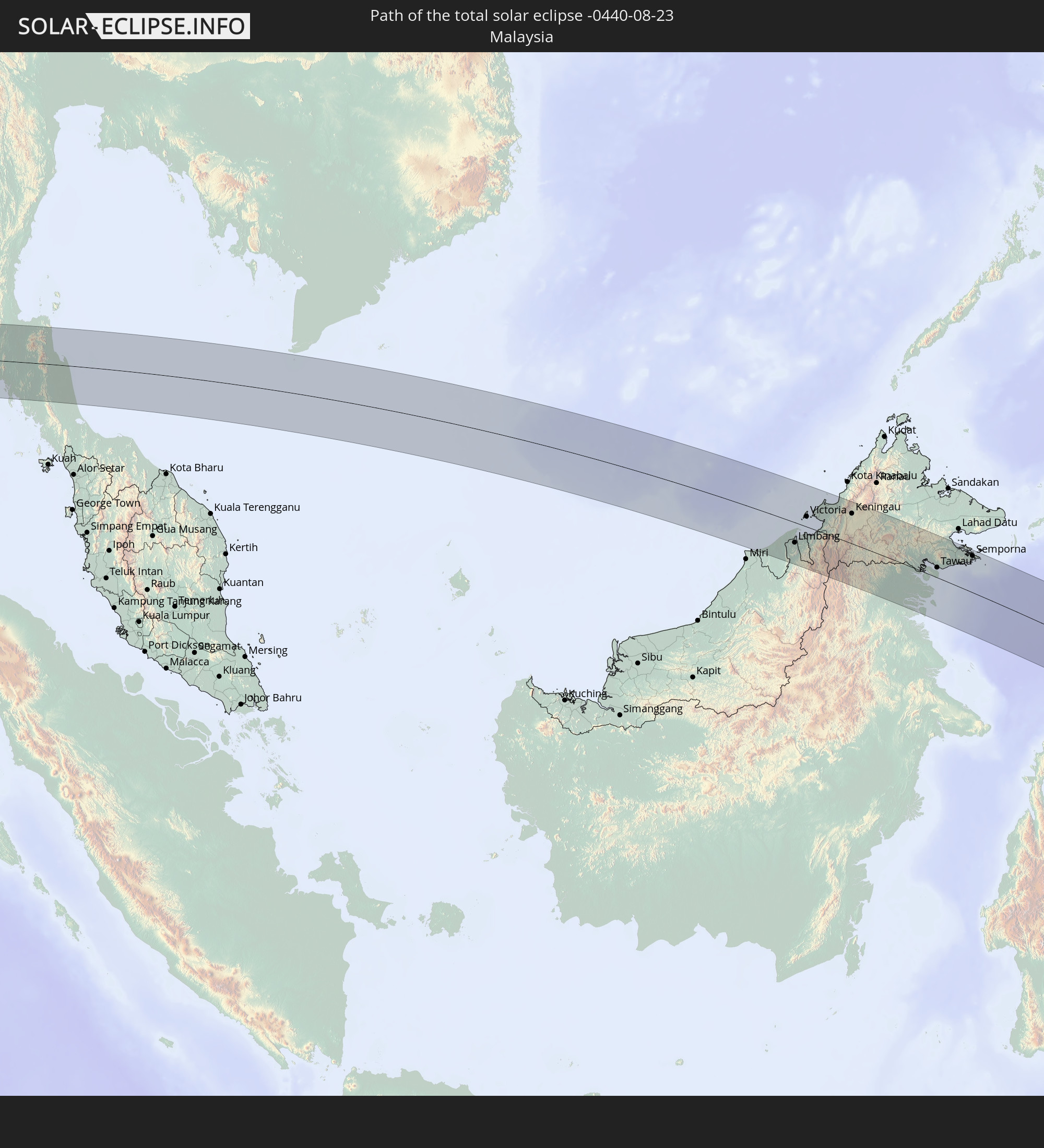 Malaysia
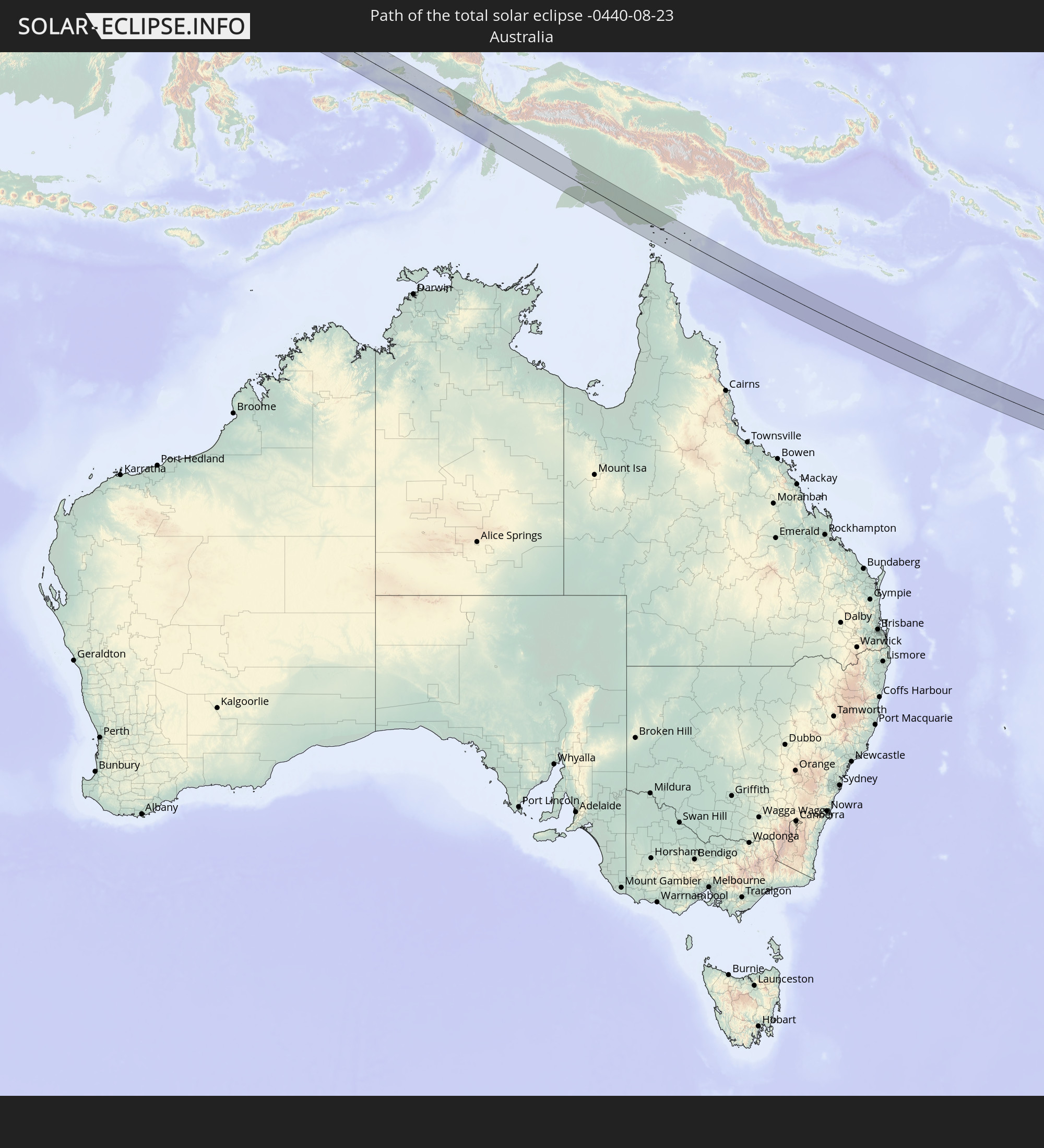 Australia
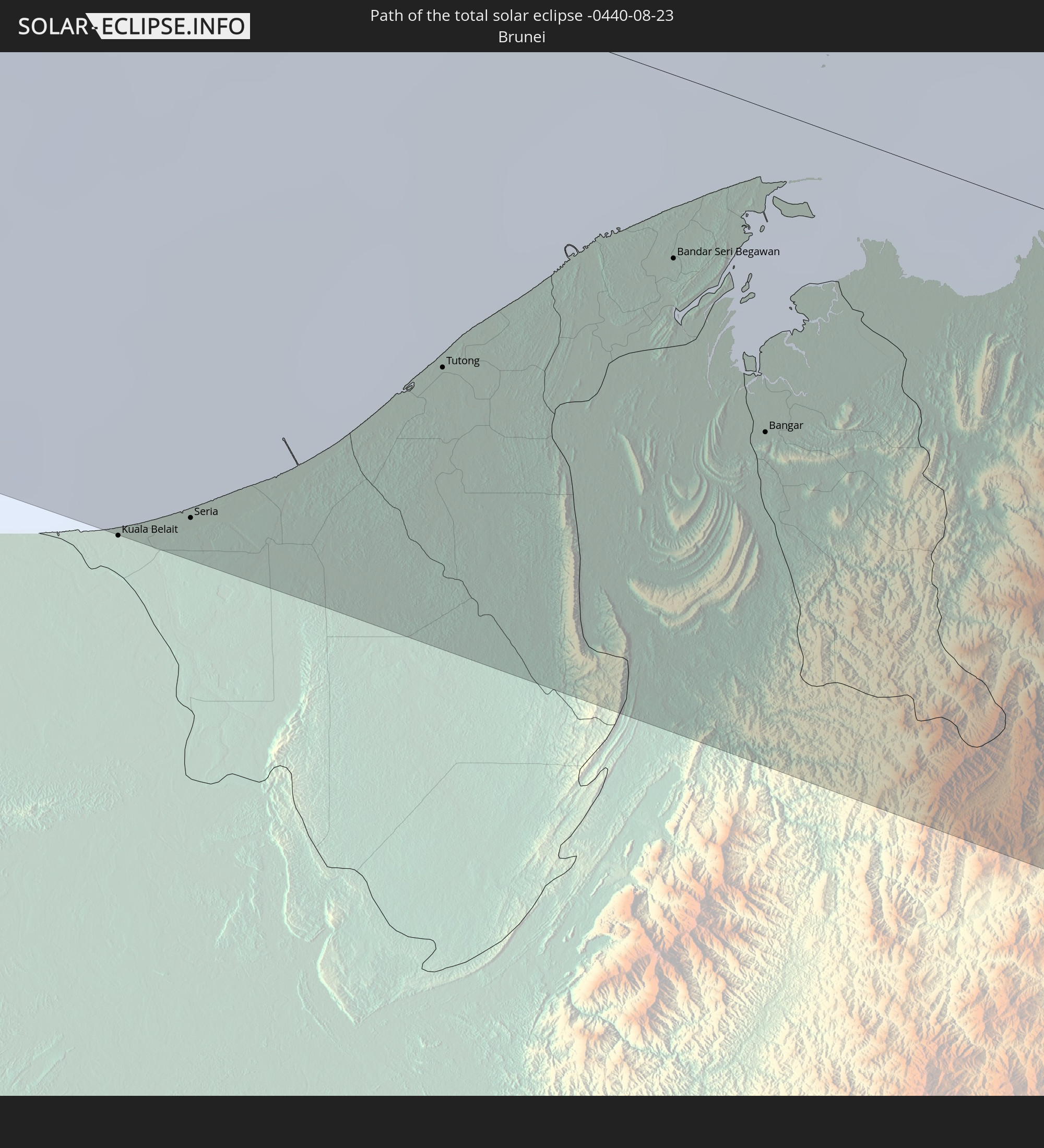 Brunei
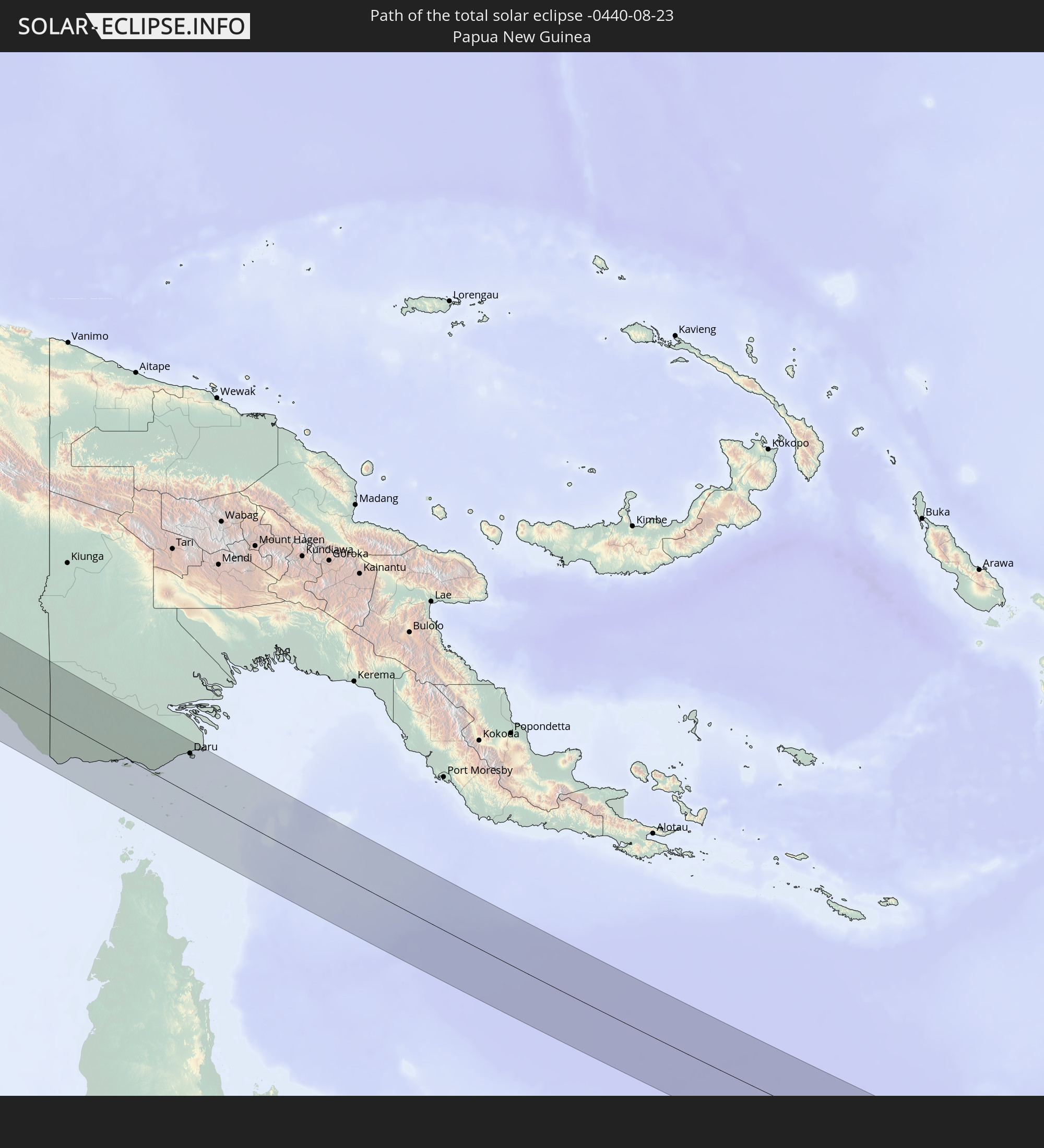 Papua New Guinea
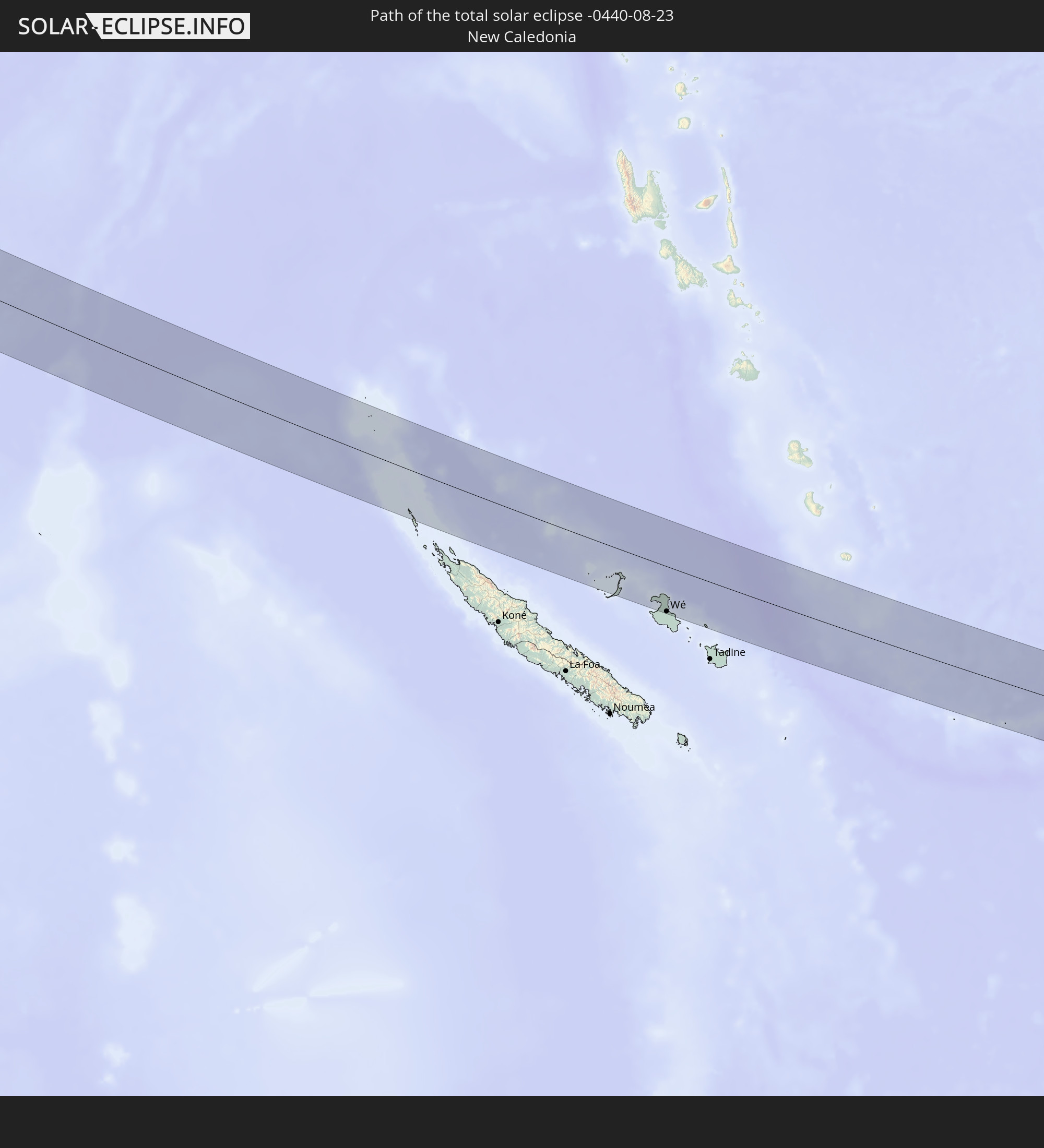 New Caledonia
In den folgenden Ländern ist die Sonnenfinsternis partiell zu sehen
 Fiji
Fiji
 New Zealand
 United States Minor Outlying Islands
 Wallis and Futuna
 Kiribati
 Saudi Arabia
 Iraq
Iraq
 Iran
Iran
 Bahrain
 Qatar
Qatar
 United Arab Emirates
 Oman
Oman
 Turkmenistan
 Uzbekistan
 Mauritius
 Afghanistan
 Pakistan
 Tajikistan
 India
India
 British Indian Ocean Territory
 Maldives
 China
China
 Sri Lanka
 Nepal
Nepal
 Bangladesh
 Bhutan
 Myanmar
 Indonesia
 Cocos Islands
 Thailand
 Malaysia
 Laos
Laos
 Vietnam
 Cambodia
 Singapore
 Christmas Island
 Australia
 Macau
Macau
 Hong Kong
 Brunei
 Taiwan
 Philippines
 Japan
Japan
 East Timor
 South Korea
 Palau
Palau
 Federated States of Micronesia
 Papua New Guinea
 Guam
Guam
 Northern Mariana Islands
 Solomon Islands
 New Caledonia
 Marshall Islands
 Vanuatu
 Nauru
Nauru
 Norfolk Island
 Tuvalu
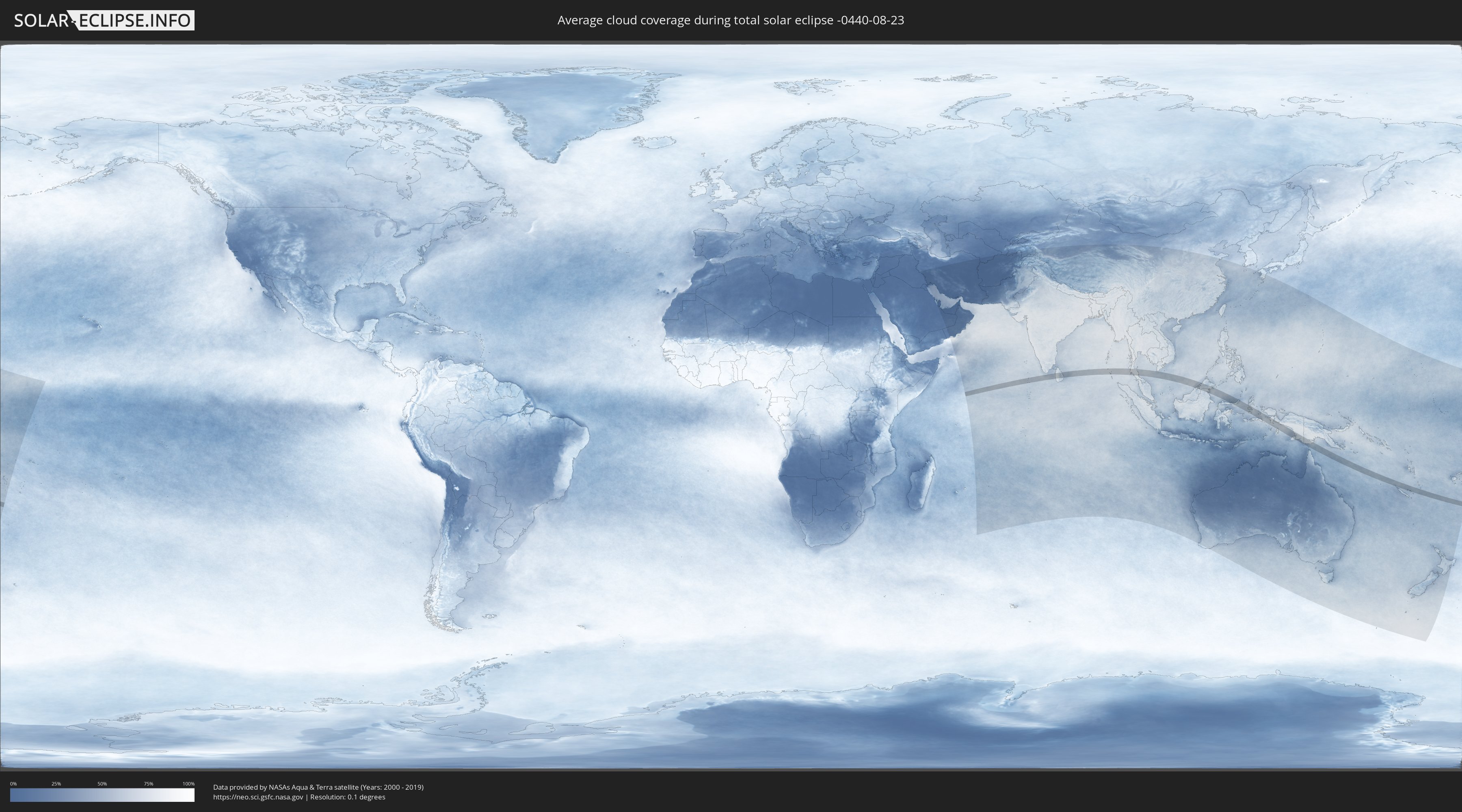
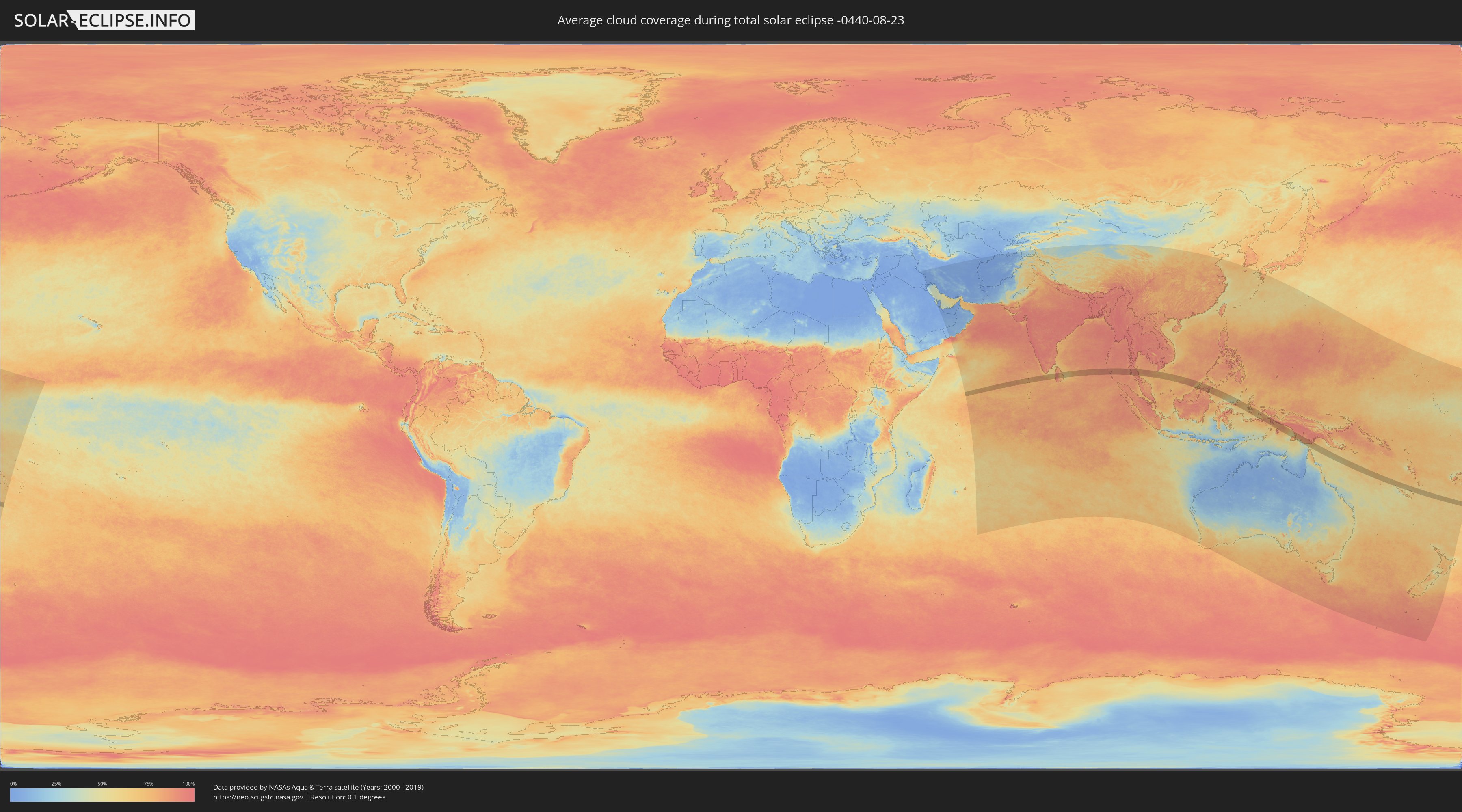
How will be the weather during the total solar eclipse on 08/23/-0440?
Where is the best place to see the total solar eclipse of 08/23/-0440?
The following maps show the average cloud coverage for the day of the total solar eclipse.
With the help of these maps, it is possible to find the place along the eclipse path, which has the best
chance of a cloudless sky.
Nevertheless, you should consider local circumstances and inform about the weather of your chosen
observation site.
The data is provided by NASAs satellites
AQUA and TERRA.
The cloud maps are averaged over a period of 19 years (2000 - 2019).
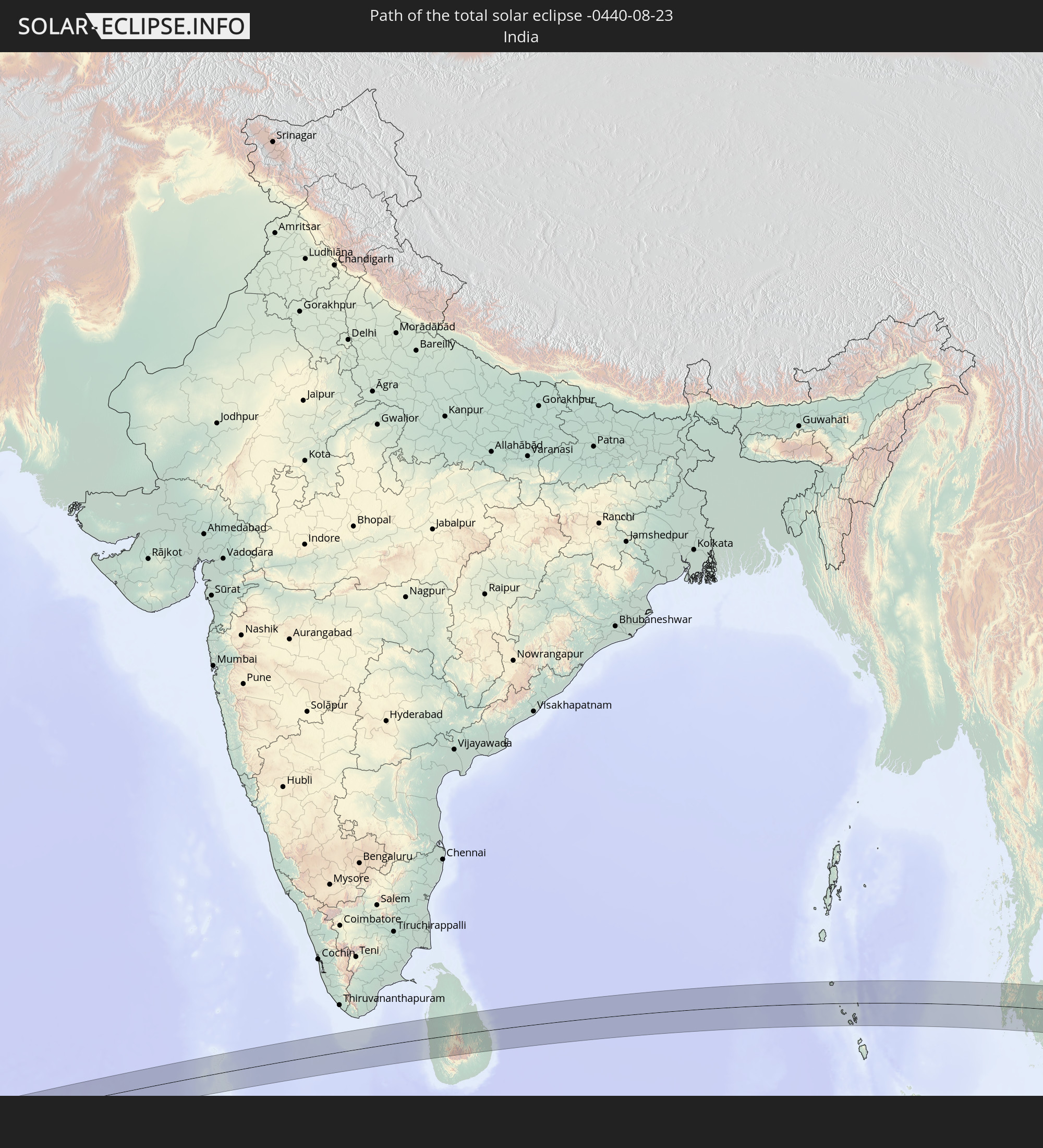
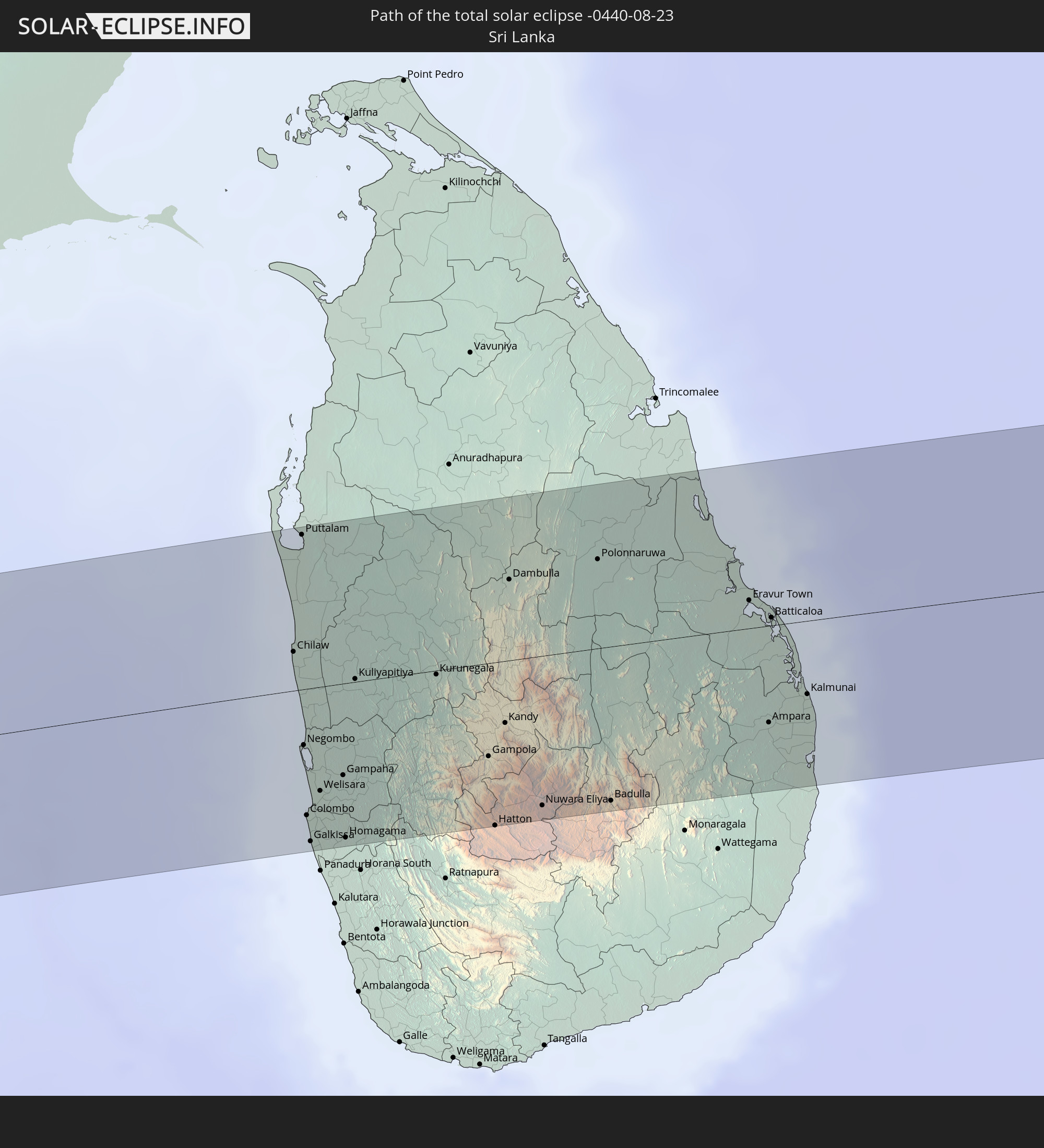
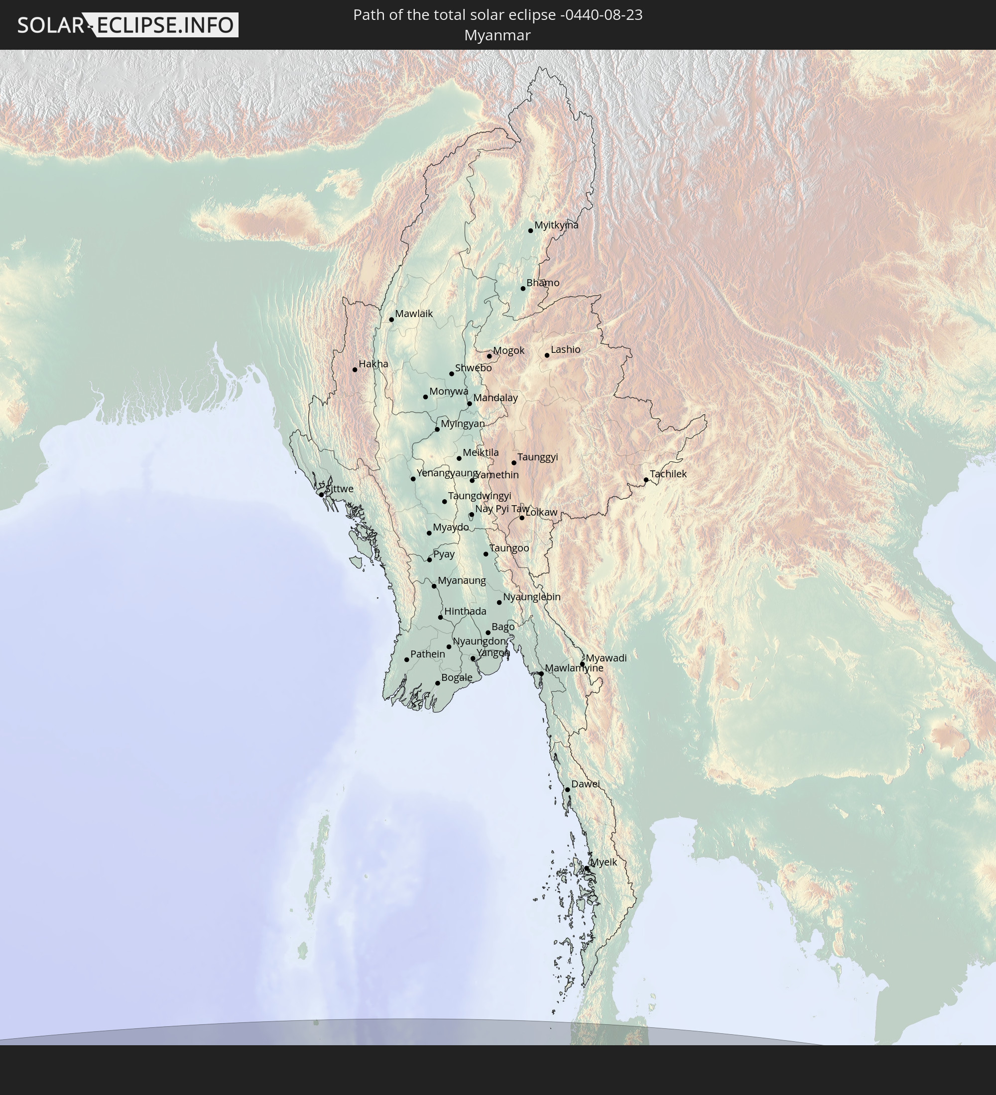
Detailed country maps
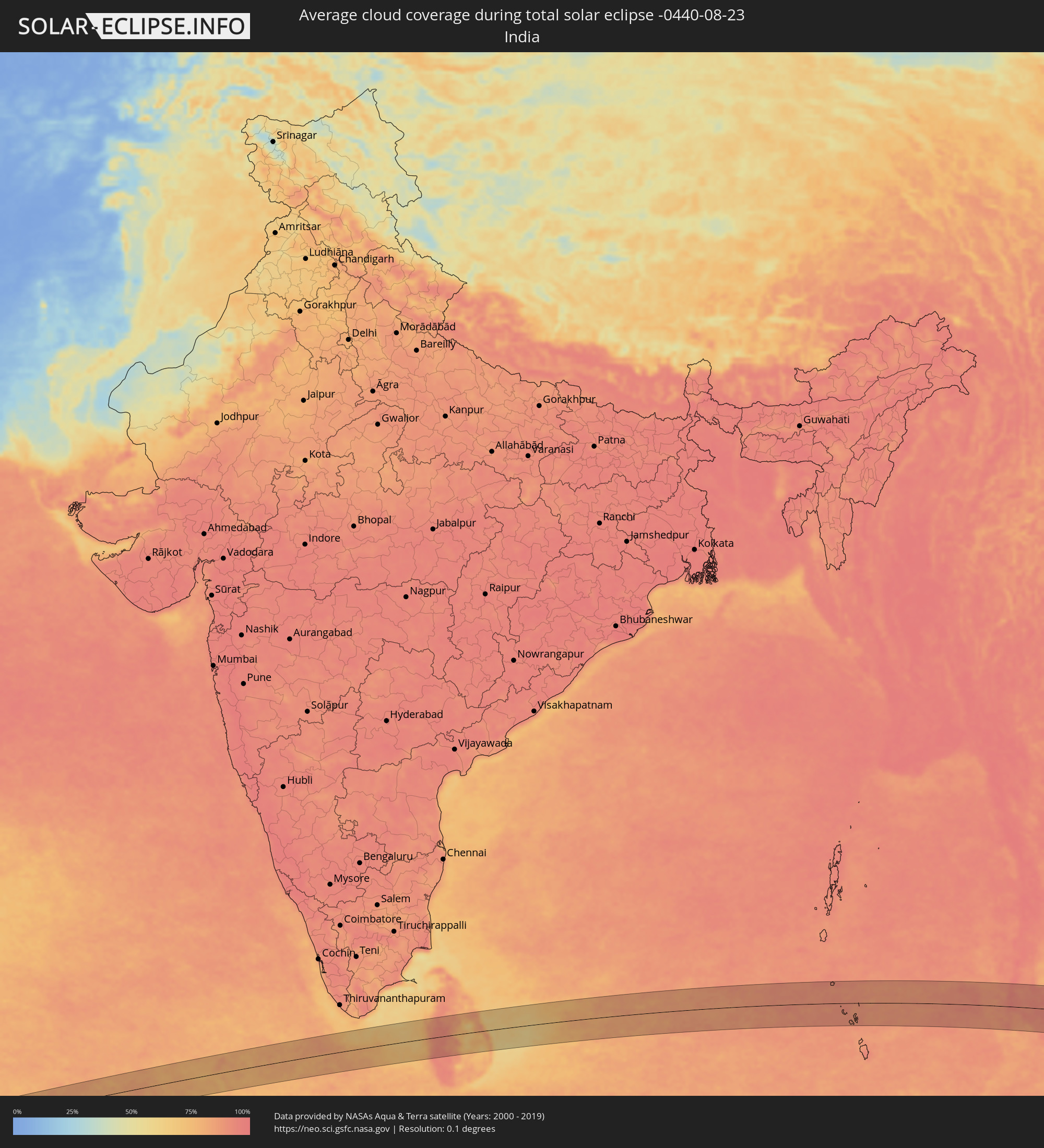 India
India
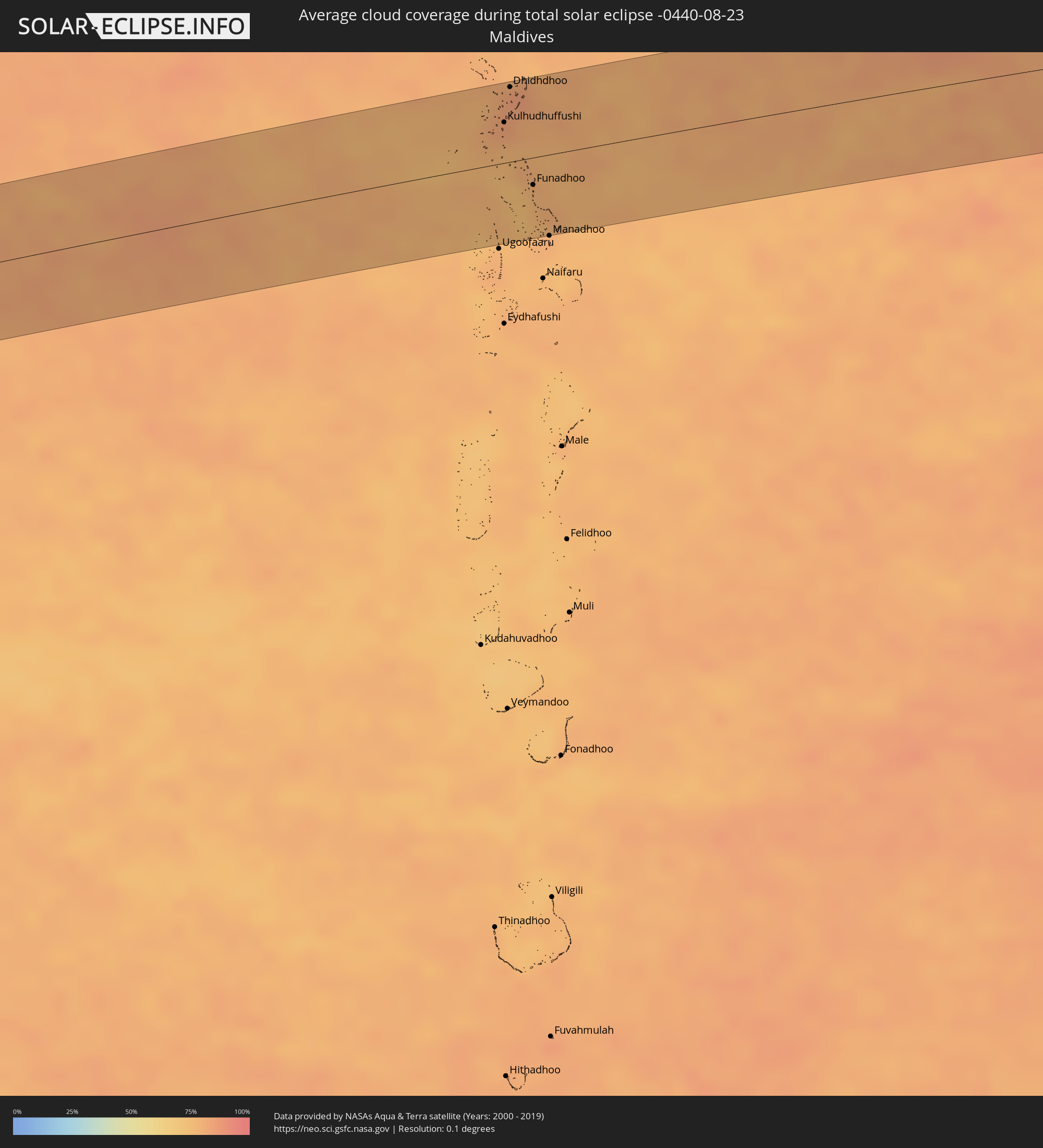 Maldives
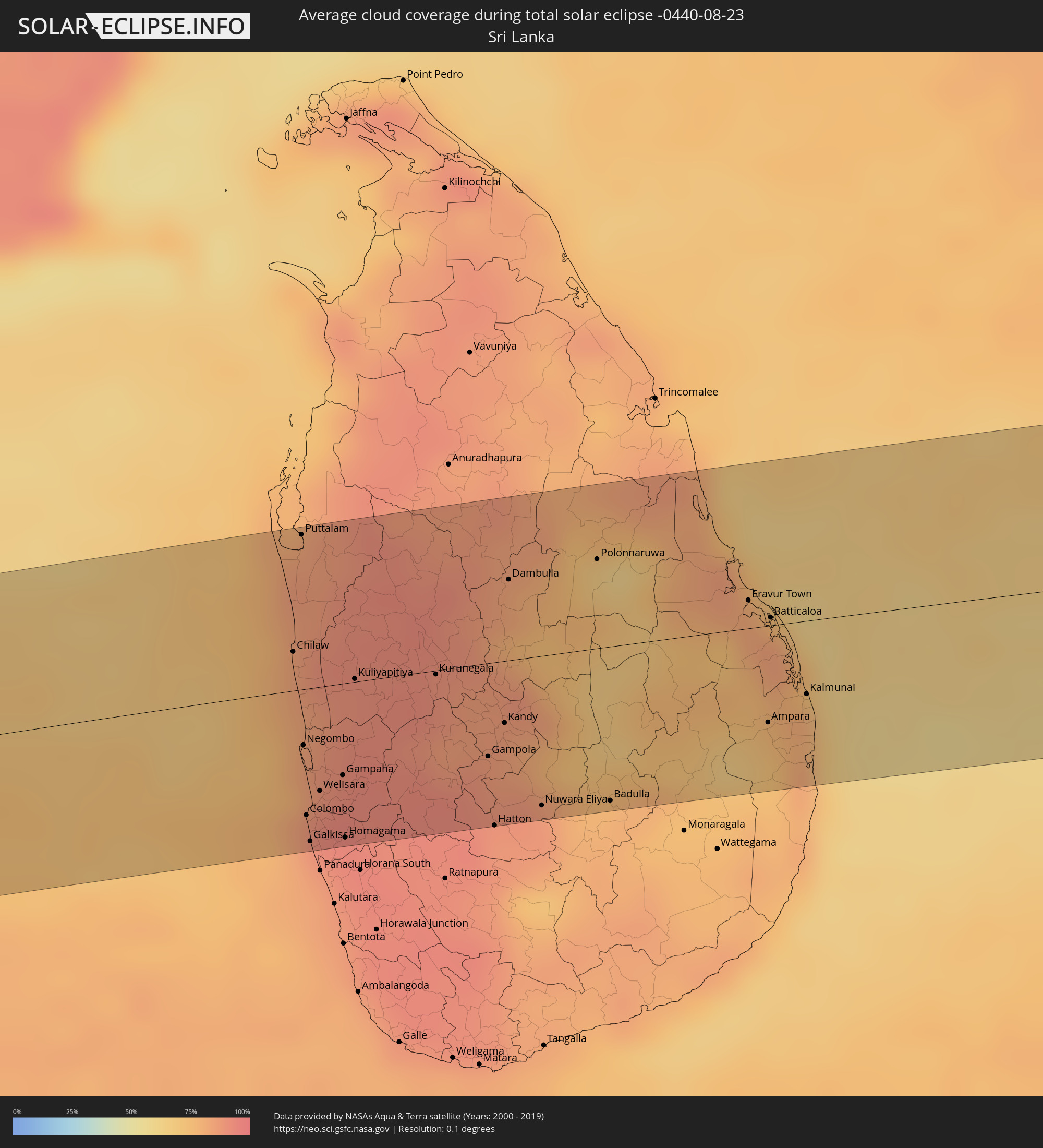 Sri Lanka
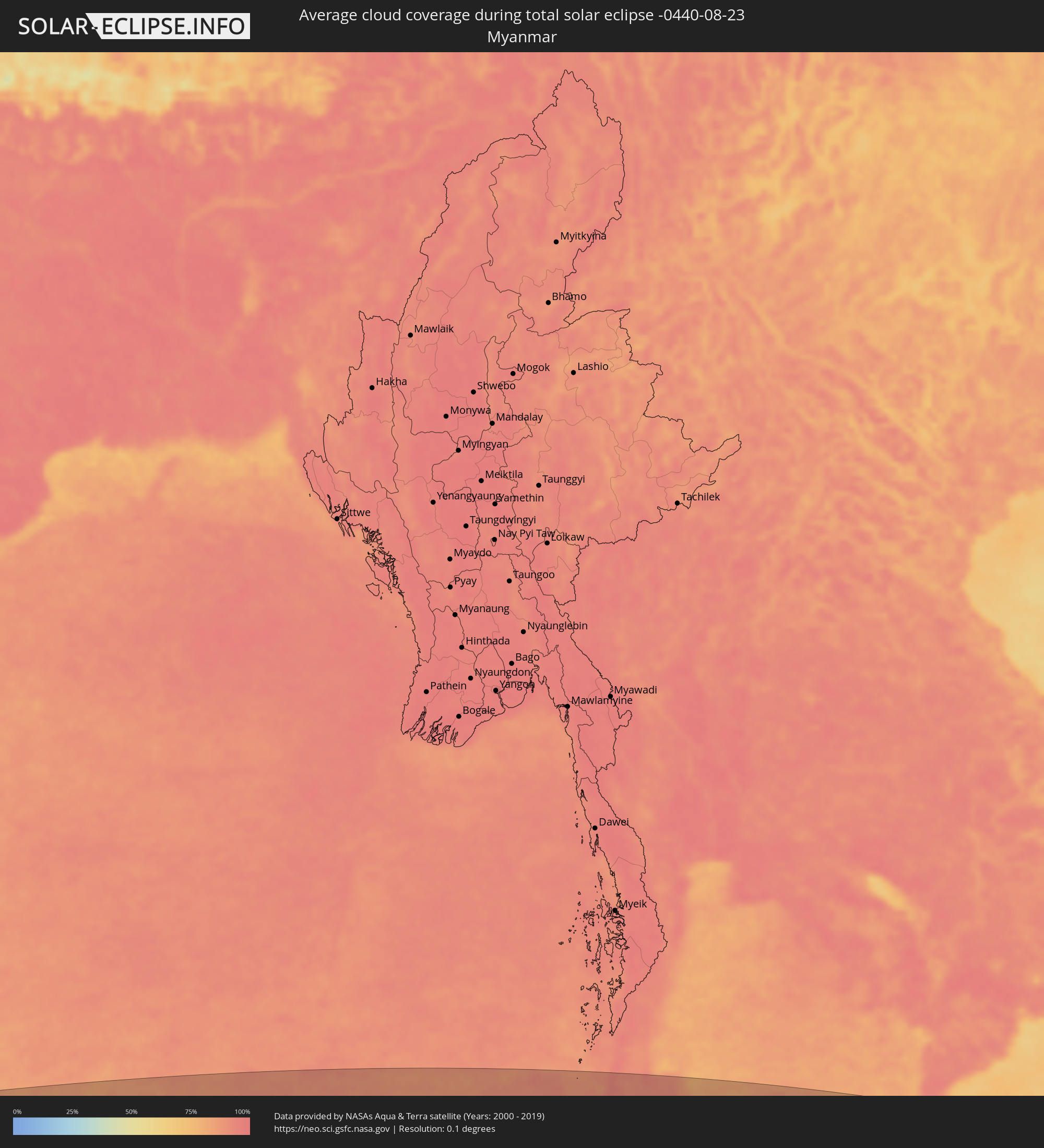 Myanmar
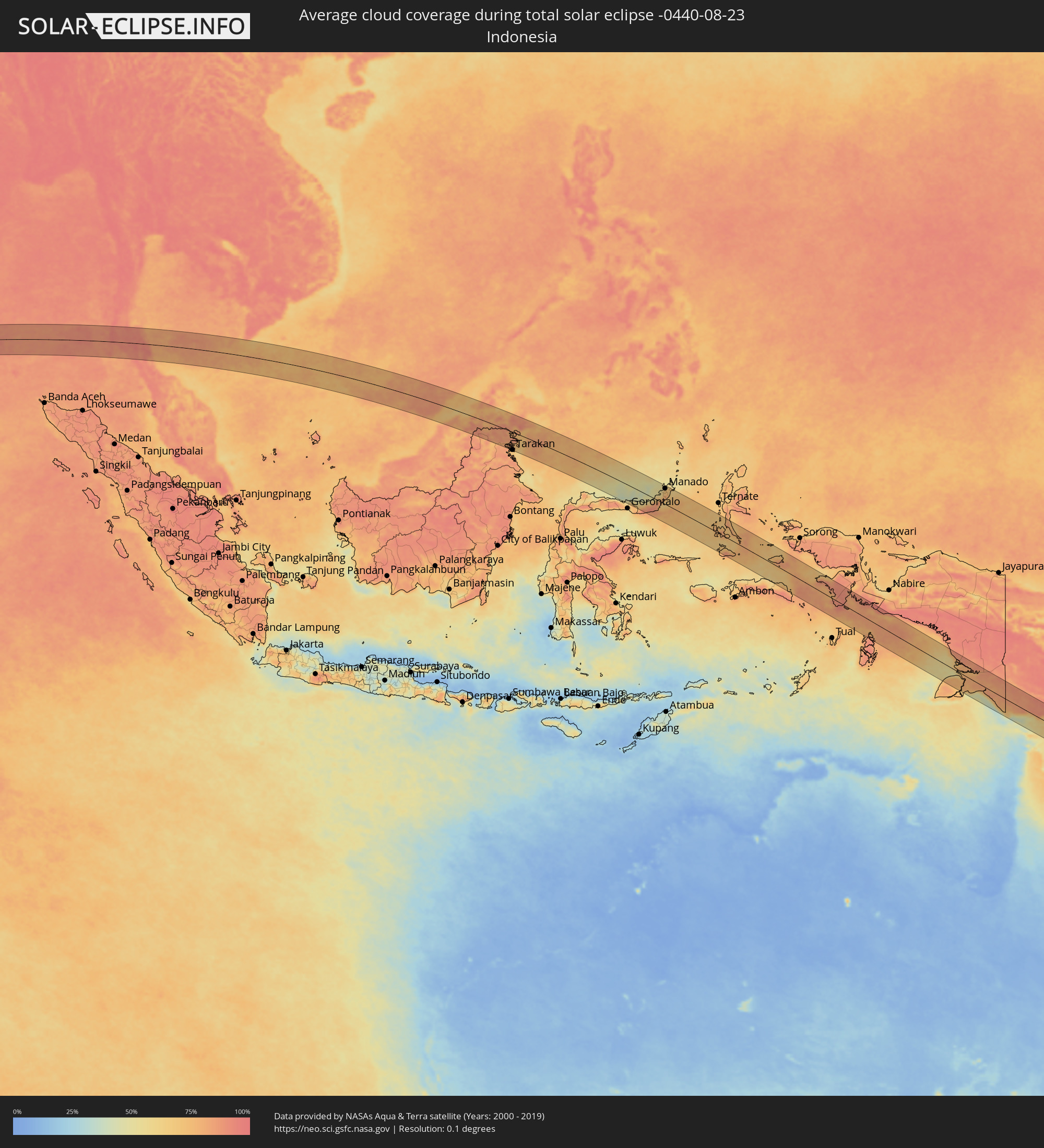 Indonesia
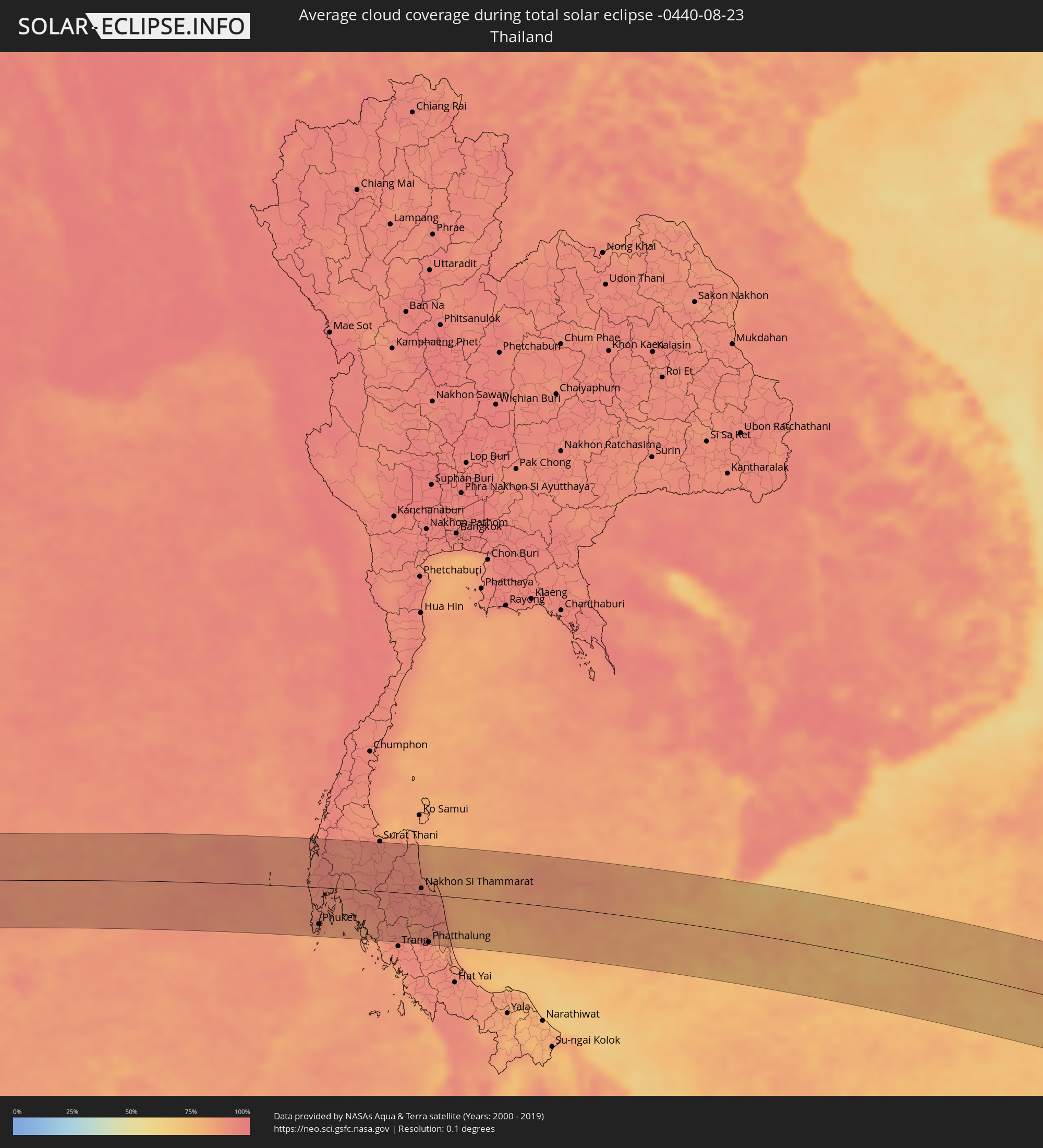 Thailand
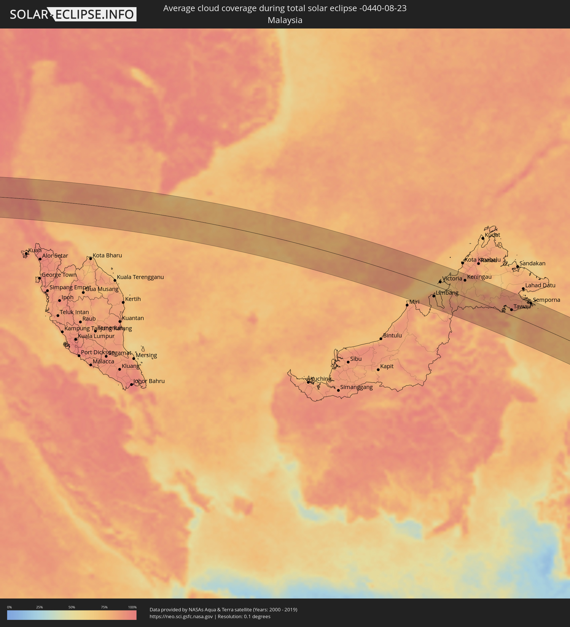 Malaysia
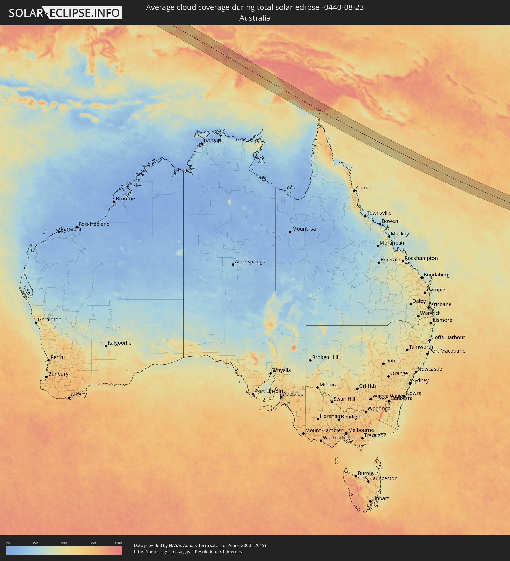 Australia
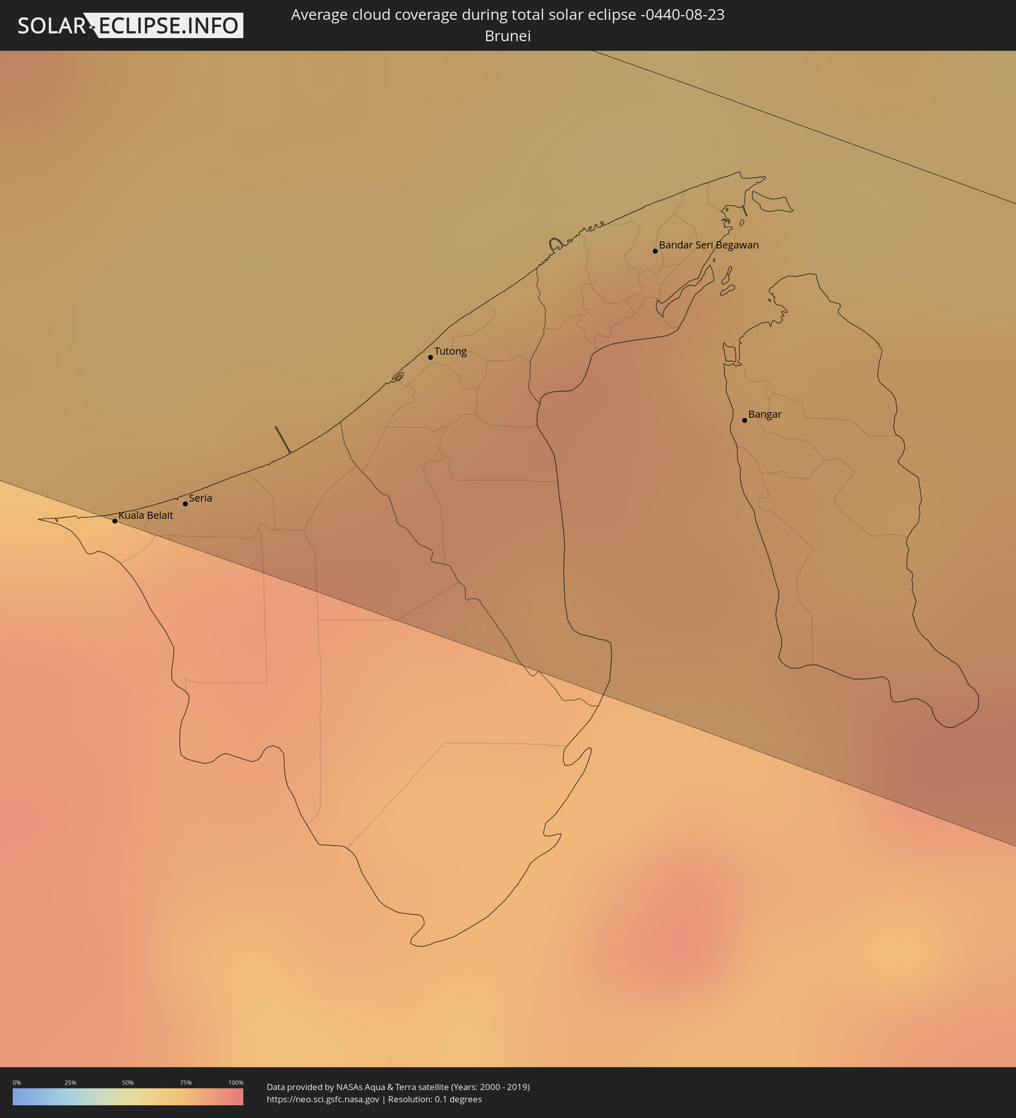 Brunei
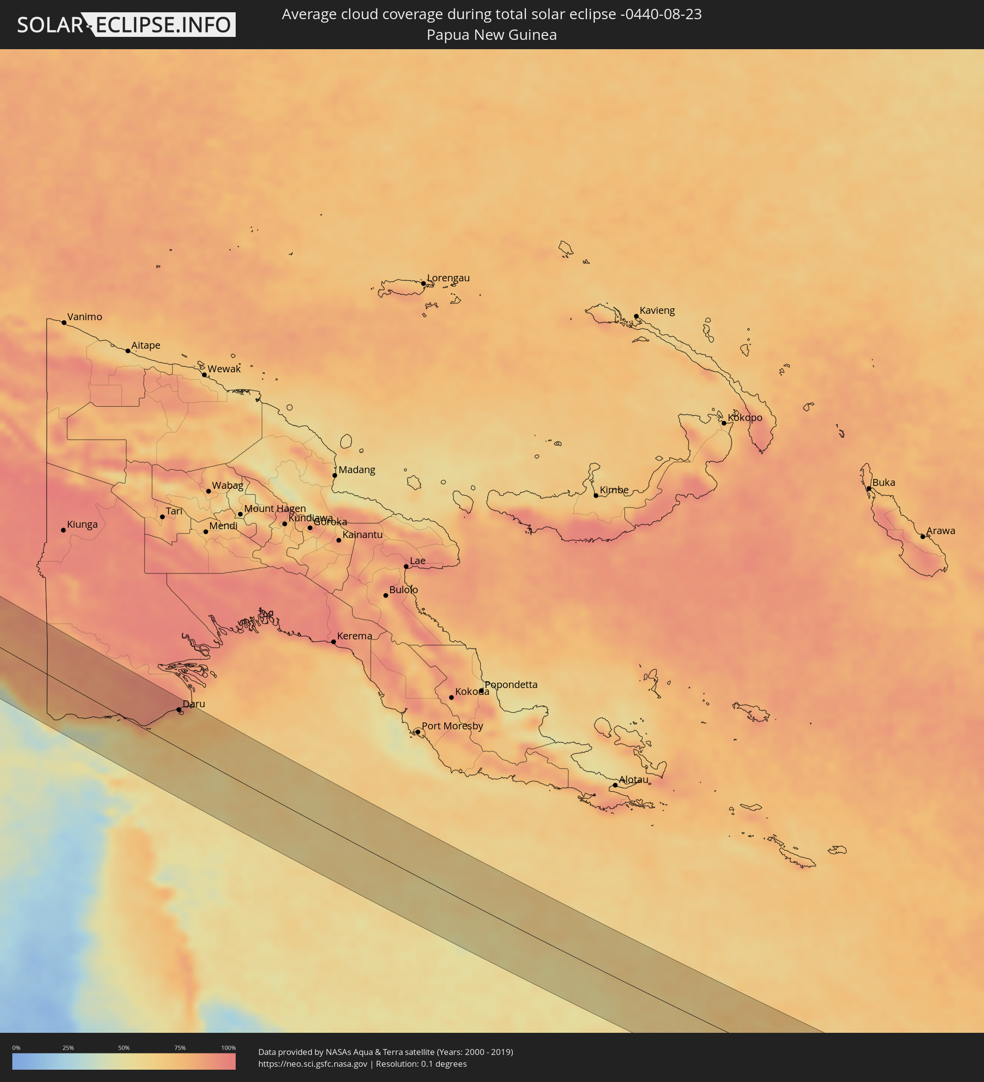 Papua New Guinea
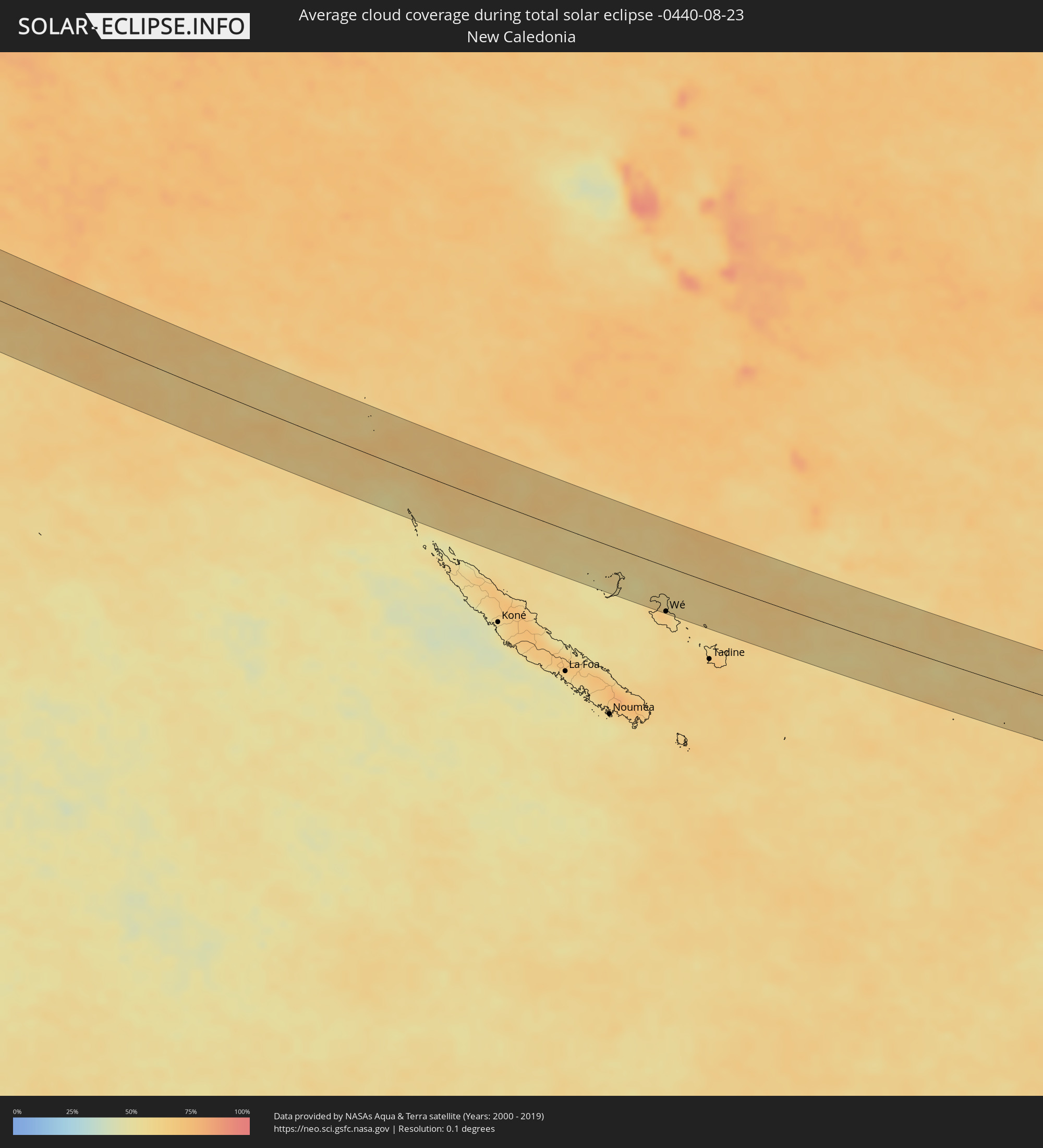 New Caledonia
Cities inside the path of the eclipse
The following table shows all locations with a population of more than 5,000 inside the eclipse path. Cities which have more than 100,000 inhabitants are marked bold. A click at the locations opens a detailed map.
| City | Type | Eclipse duration | Local time of max. eclipse | Distance to central line | Ø Cloud coverage |
|
Kulhudhuffushi, Haa Dhaalu Atholhu
|
total | - | 07:07:04 UTC+04:54 | 34 km | 82% |
|
Dhidhdhoo, Haa Alifu Atholhu
|
total | - | 07:07:04 UTC+04:54 | 62 km | 83% |
|
Funadhoo, Shaviyani Atholhu
|
total | - | 07:07:15 UTC+04:54 | 22 km | 78% |
|
Chilaw, North Western
|
total | - | 07:37:56 UTC+05:19 | 17 km | 83% |
|
Puttalam, North Western
|
total | - | 07:37:54 UTC+05:19 | 67 km | 84% |
|
Negombo, Western
|
total | - | 07:38:01 UTC+05:19 | 24 km | 80% |
|
Colombo, Western
|
total | - | 07:38:04 UTC+05:19 | 55 km | 82% |
|
Hendala, Western
|
total | - | 07:38:06 UTC+05:19 | 49 km | 91% |
|
Peliyagoda, Western
|
total | - | 07:38:06 UTC+05:19 | 51 km | 91% |
|
Wattala, Western
|
total | - | 07:38:06 UTC+05:19 | 50 km | 91% |
|
Ja Ela, Western
|
total | - | 07:38:05 UTC+05:19 | 40 km | 87% |
|
Kandana, Western
|
total | - | 07:38:06 UTC+05:19 | 43 km | 91% |
|
Welisara, Western
|
total | - | 07:38:06 UTC+05:19 | 45 km | 91% |
|
Kelaniya, Western
|
total | - | 07:38:08 UTC+05:19 | 53 km | 91% |
|
Mulleriyawa, Western
|
total | - | 07:38:09 UTC+05:19 | 56 km | 91% |
|
Homagama, Western
|
total | - | 07:38:14 UTC+05:19 | 67 km | 92% |
|
Hanwella Ihala, Western
|
total | - | 07:38:19 UTC+05:19 | 62 km | 93% |
|
Kurunegala, North Western
|
total | - | 07:38:30 UTC+05:19 | 2 km | 89% |
|
Gampola, Central
|
total | - | 07:38:46 UTC+05:19 | 40 km | 86% |
|
Kandy, Central
|
total | - | 07:38:49 UTC+05:19 | 27 km | 86% |
|
Dambulla, Central
|
total | - | 07:38:45 UTC+05:19 | 35 km | 80% |
|
Nuwara Eliya, Central
|
total | - | 07:39:01 UTC+05:19 | 65 km | 86% |
|
Badulla, Uva
|
total | - | 07:39:18 UTC+05:19 | 67 km | 79% |
|
Eravur Town, Eastern Province
|
total | - | 07:39:46 UTC+05:19 | 12 km | 81% |
|
Ampara, Eastern Province
|
total | - | 07:39:55 UTC+05:19 | 42 km | 75% |
|
Batticaloa, Eastern Province
|
total | - | 07:39:52 UTC+05:19 | 3 km | 83% |
|
Kalmunai, Eastern Province
|
total | - | 07:40:04 UTC+05:19 | 32 km | 80% |
|
Shanjeev Home, Eastern Province
|
total | - | 07:40:05 UTC+05:19 | 35 km | 80% |
|
Patong, Phuket
|
total | - | 09:29:06 UTC+06:42 | 62 km | 88% |
|
Ban Karon, Phuket
|
total | - | 09:29:07 UTC+06:42 | 67 km | 84% |
|
Rawai, Phuket
|
total | - | 09:29:13 UTC+06:42 | 75 km | 84% |
|
Ban Chalong, Phuket
|
total | - | 09:29:13 UTC+06:42 | 67 km | 84% |
|
Ban Talat Nua, Phuket
|
total | - | 09:29:18 UTC+06:42 | 63 km | 91% |
|
Ban Ko Kaeo, Phuket
|
total | - | 09:29:17 UTC+06:42 | 57 km | 91% |
|
Phuket, Phuket
|
total | - | 09:29:19 UTC+06:42 | 62 km | 91% |
|
Ban Ratsada, Phuket
|
total | - | 09:29:19 UTC+06:42 | 60 km | 91% |
|
Phang Nga, Phangnga
|
total | - | 09:29:20 UTC+06:42 | 1 km | 92% |
|
Ao Luek, Krabi
|
total | - | 09:29:47 UTC+06:42 | 6 km | 89% |
|
Ban Ao Nang, Phangnga
|
total | - | 09:30:08 UTC+06:42 | 42 km | 85% |
|
Krabi, Krabi
|
total | - | 09:30:20 UTC+06:42 | 38 km | 88% |
|
Nuea Khlong, Krabi
|
total | - | 09:30:32 UTC+06:42 | 38 km | 89% |
|
Phunphin, Surat Thani
|
total | - | 09:30:32 UTC+06:42 | 79 km | 93% |
|
Ban Na San, Surat Thani
|
total | - | 09:30:58 UTC+06:42 | 46 km | 90% |
|
Wiang Sa, Surat Thani
|
total | - | 09:31:04 UTC+06:42 | 28 km | 92% |
|
Tham Phannara, Nakhon Si Thammarat
|
total | - | 09:31:14 UTC+06:42 | 4 km | 93% |
|
Chawang, Nakhon Si Thammarat
|
total | - | 09:31:28 UTC+06:42 | 5 km | 93% |
|
Huai Yot, Trang
|
total | - | 09:32:05 UTC+06:42 | 64 km | 90% |
|
Thung Song, Nakhon Si Thammarat
|
total | - | 09:32:00 UTC+06:42 | 22 km | 93% |
|
Ron Phibun, Nakhon Si Thammarat
|
total | - | 09:32:23 UTC+06:42 | 19 km | 93% |
|
Nakhon Si Thammarat, Nakhon Si Thammarat
|
total | - | 09:32:30 UTC+06:42 | 10 km | 94% |
|
Phatthalung, Phatthalung
|
total | - | 09:33:11 UTC+06:42 | 79 km | 92% |
|
Pak Phanang, Nakhon Si Thammarat
|
total | - | 09:33:04 UTC+06:42 | 3 km | 90% |
|
Ranot, Songkhla
|
total | - | 09:33:39 UTC+06:42 | 59 km | 86% |
|
Seria, Belait
|
total | - | 11:11:27 UTC+07:39 | 83 km | 84% |
|
Tutong, Tutong
|
total | - | 11:12:11 UTC+07:39 | 51 km | 82% |
|
Bandar Seri Begawan, Brunei and Muara
|
total | - | 11:12:54 UTC+07:39 | 25 km | 84% |
|
Limbang, Sarawak
|
total | - | 10:54:56 UTC+07:21 | 43 km | 81% |
|
Bangar, Temburong
|
total | - | 11:13:30 UTC+07:39 | 44 km | 78% |
|
Victoria, Labuan
|
total | - | 10:55:02 UTC+07:21 | 22 km | 69% |
|
Bandar Labuan, Sabah
|
total | - | 10:55:06 UTC+07:21 | 24 km | 70% |
|
Beaufort, Sabah
|
total | - | 10:56:25 UTC+07:21 | 48 km | 73% |
|
Keningau, Sabah
|
total | - | 10:57:39 UTC+07:21 | 63 km | 76% |
|
Sembakung, East Kalimantan
|
total | - | 11:38:56 UTC+07:57 | 50 km | 81% |
|
Tarakan, North Kalimantan
|
total | - | 11:40:34 UTC+07:57 | 88 km | 70% |
|
Tawau, Sabah
|
total | - | 11:04:02 UTC+07:21 | 21 km | 80% |
|
Semporna, Sabah
|
total | - | 03:44:30 UTC+00:00 | 76 km | 78% |
|
Tomohon, North Sulawesi
|
total | - | 12:04:01 UTC+07:57 | 55 km | 70% |
|
Manado, North Sulawesi
|
total | - | 12:03:55 UTC+07:57 | 73 km | 65% |
|
Tondano, North Sulawesi
|
total | - | 12:04:20 UTC+07:57 | 59 km | 72% |
|
Laikit, Laikit II (Dimembe), North Sulawesi
|
total | - | 12:04:15 UTC+07:57 | 81 km | 69% |
|
Daru, Western Province
|
total | - | 15:00:16 UTC+10:00 | 60 km | 76% |
|
Wé, Loyalty Islands
|
total | - | 16:35:48 UTC+11:05 | 63 km | 63% |