Total solar eclipse of 08/10/-0504
| Day of week: | Saturday |
| Maximum duration of eclipse: | 04m43s |
| Maximum width of eclipse path: | 210 km |
| Saros cycle: | 66 |
| Coverage: | 100% |
| Magnitude: | 1.0528 |
| Gamma: | -0.5679 |
Wo kann man die Sonnenfinsternis vom 08/10/-0504 sehen?
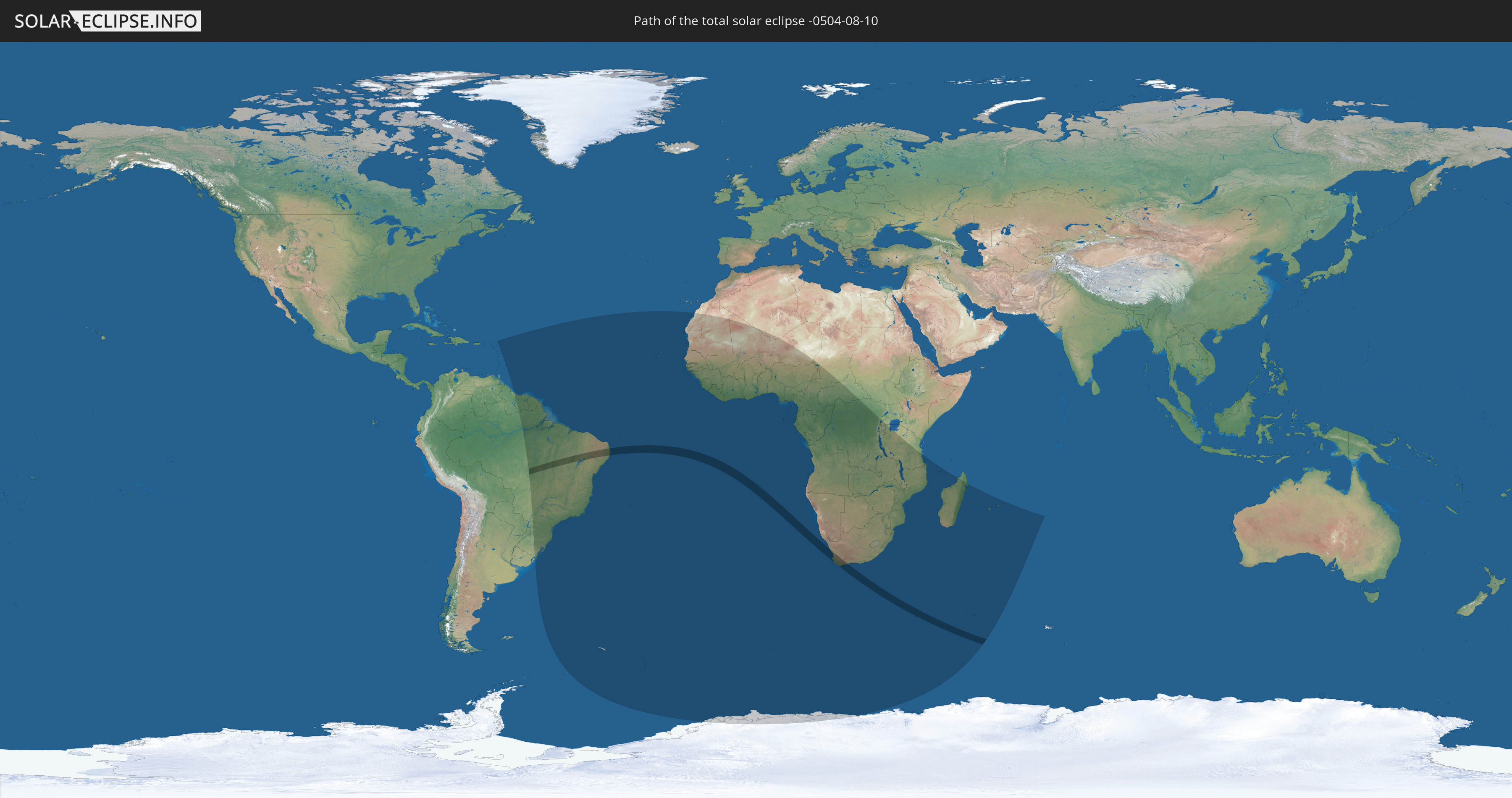
Die Sonnenfinsternis am 08/10/-0504 kann man in 54 Ländern als partielle Sonnenfinsternis beobachten.
Der Finsternispfad verläuft durch 3 Länder. Nur in diesen Ländern ist sie als total Sonnenfinsternis zu sehen.
In den folgenden Ländern ist die Sonnenfinsternis total zu sehen
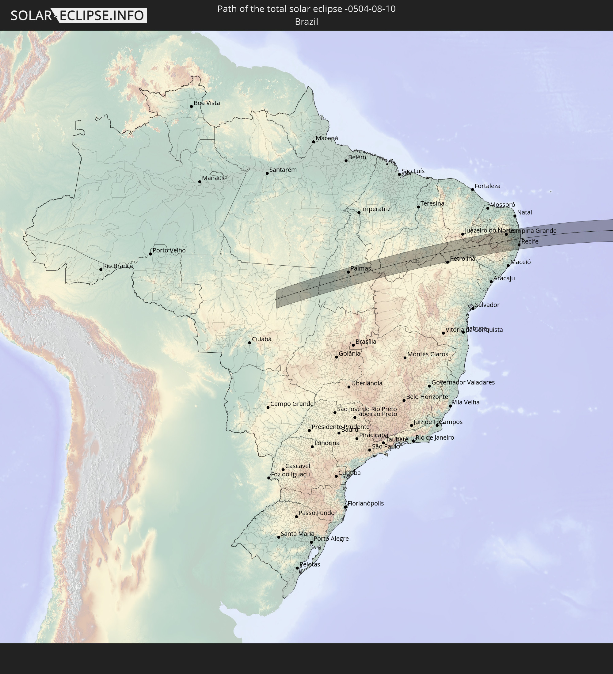 Brazil
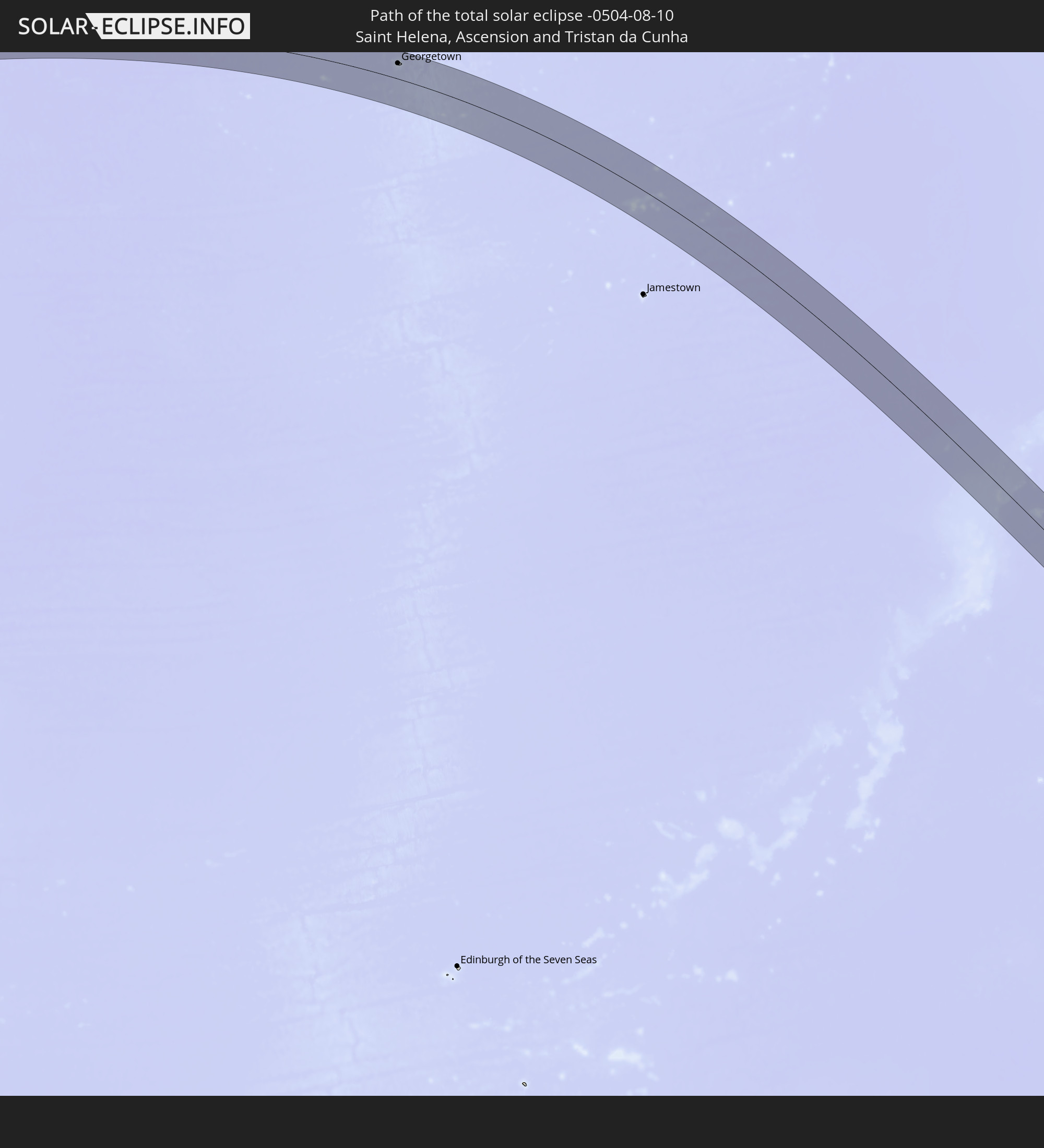 Saint Helena, Ascension and Tristan da Cunha
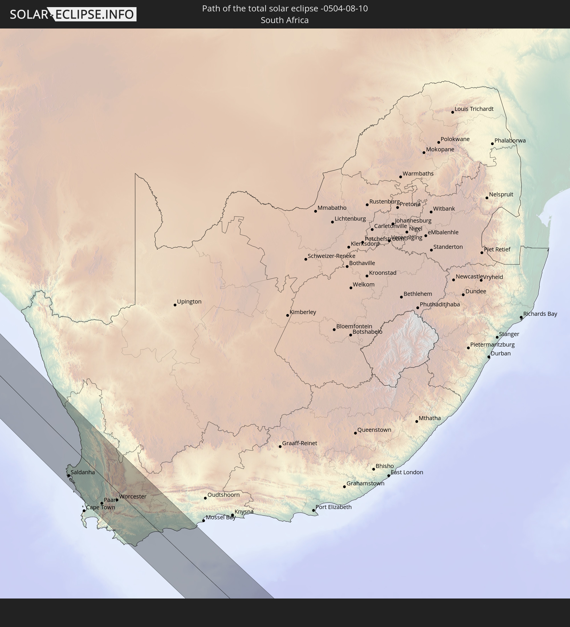 South Africa
In den folgenden Ländern ist die Sonnenfinsternis partiell zu sehen
 Antarctica
 Brazil
 Guyana
 Barbados
 Suriname
 French Guiana
 South Georgia and the South Sandwich Islands
 Cabo Verde
 Senegal
 Mauritania
 The Gambia
 Guinea-Bissau
 Guinea
 Saint Helena, Ascension and Tristan da Cunha
 Sierra Leone
 Mali
Mali
 Liberia
 Algeria
 Ivory Coast
 Burkina Faso
 Ghana
Ghana
 Togo
Togo
 Niger
Niger
 Benin
Benin
 Nigeria
 Bouvet Island
 Equatorial Guinea
 São Tomé and Príncipe
 Cameroon
 Gabon
Gabon
 Republic of the Congo
 Angola
 Namibia
 Democratic Republic of the Congo
 Chad
Chad
 Central African Republic
 South Africa
 Botswana
 Zambia
 Zimbabwe
 Lesotho
 Rwanda
 Burundi
 Tanzania
 Uganda
 Mozambique
 Swaziland
 Malawi
 French Southern and Antarctic Lands
 Madagascar
 Comoros
 Mayotte
 Réunion
 Mauritius
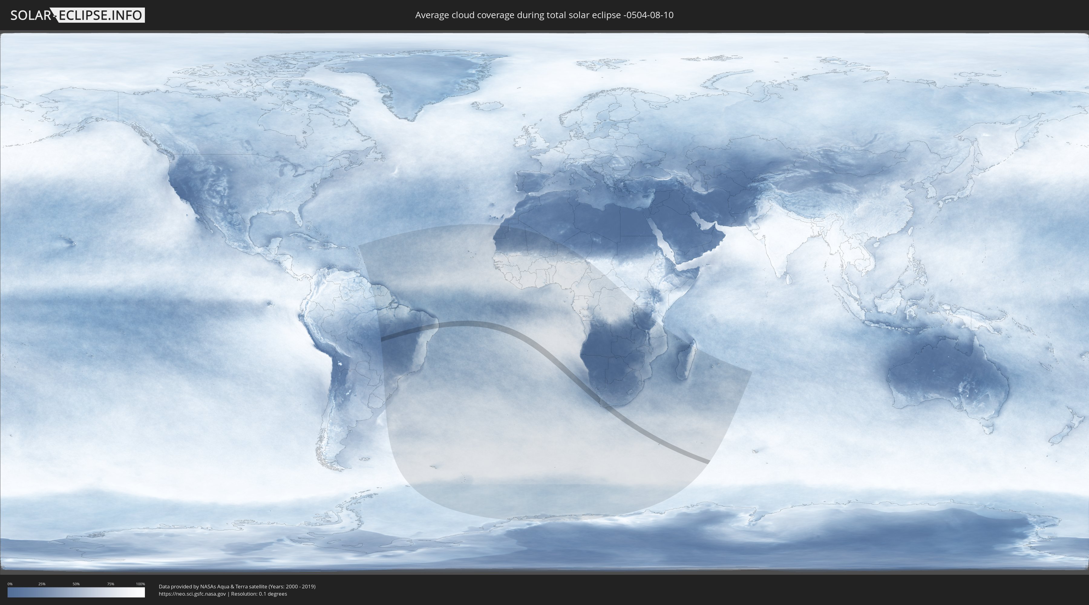
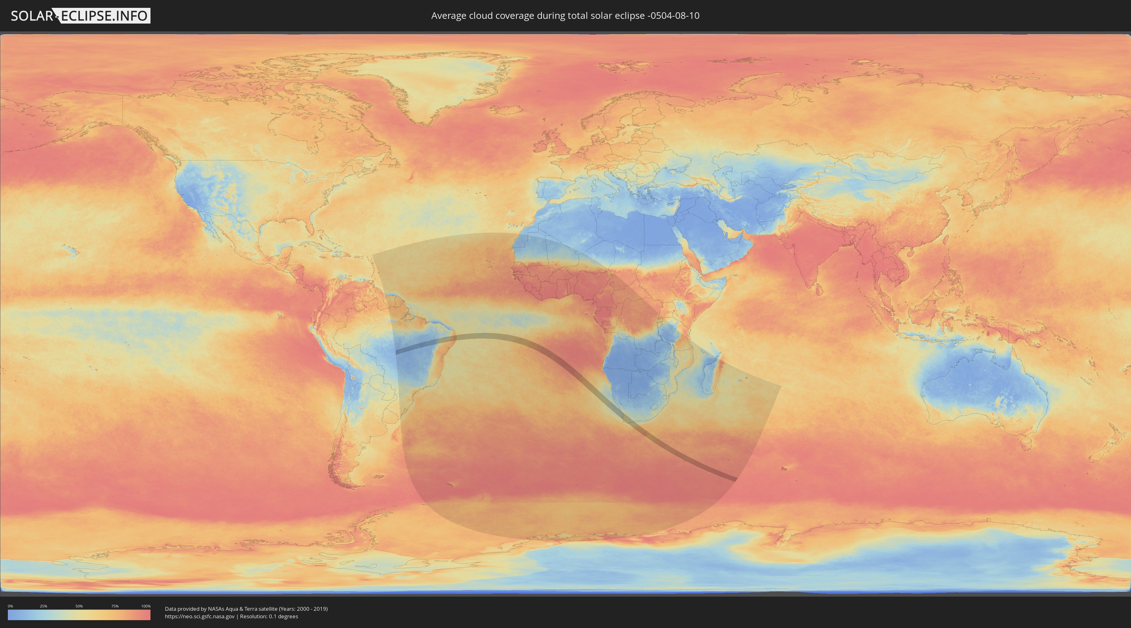
How will be the weather during the total solar eclipse on 08/10/-0504?
Where is the best place to see the total solar eclipse of 08/10/-0504?
The following maps show the average cloud coverage for the day of the total solar eclipse.
With the help of these maps, it is possible to find the place along the eclipse path, which has the best
chance of a cloudless sky.
Nevertheless, you should consider local circumstances and inform about the weather of your chosen
observation site.
The data is provided by NASAs satellites
AQUA and TERRA.
The cloud maps are averaged over a period of 19 years (2000 - 2019).
Detailed country maps
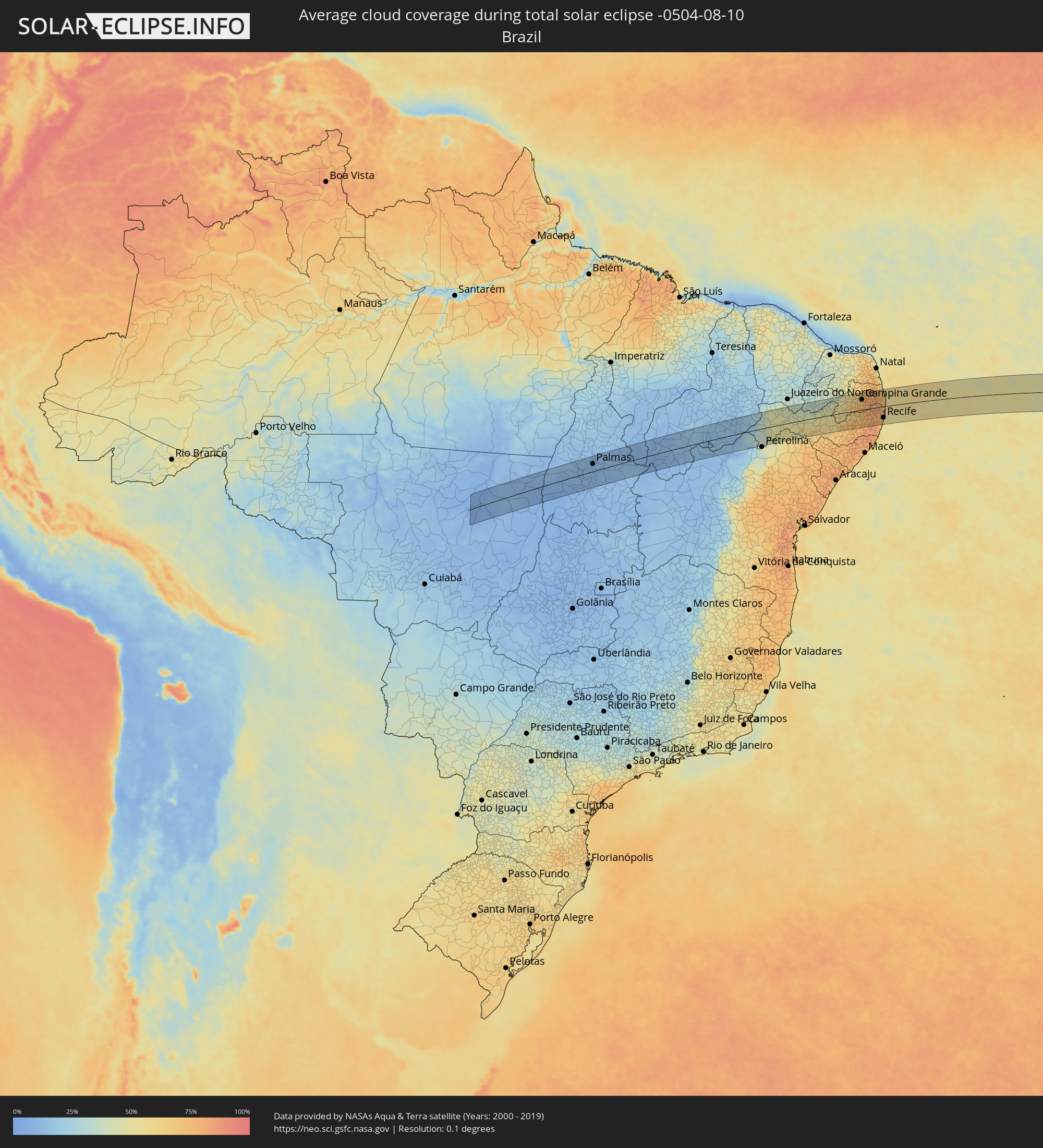 Brazil
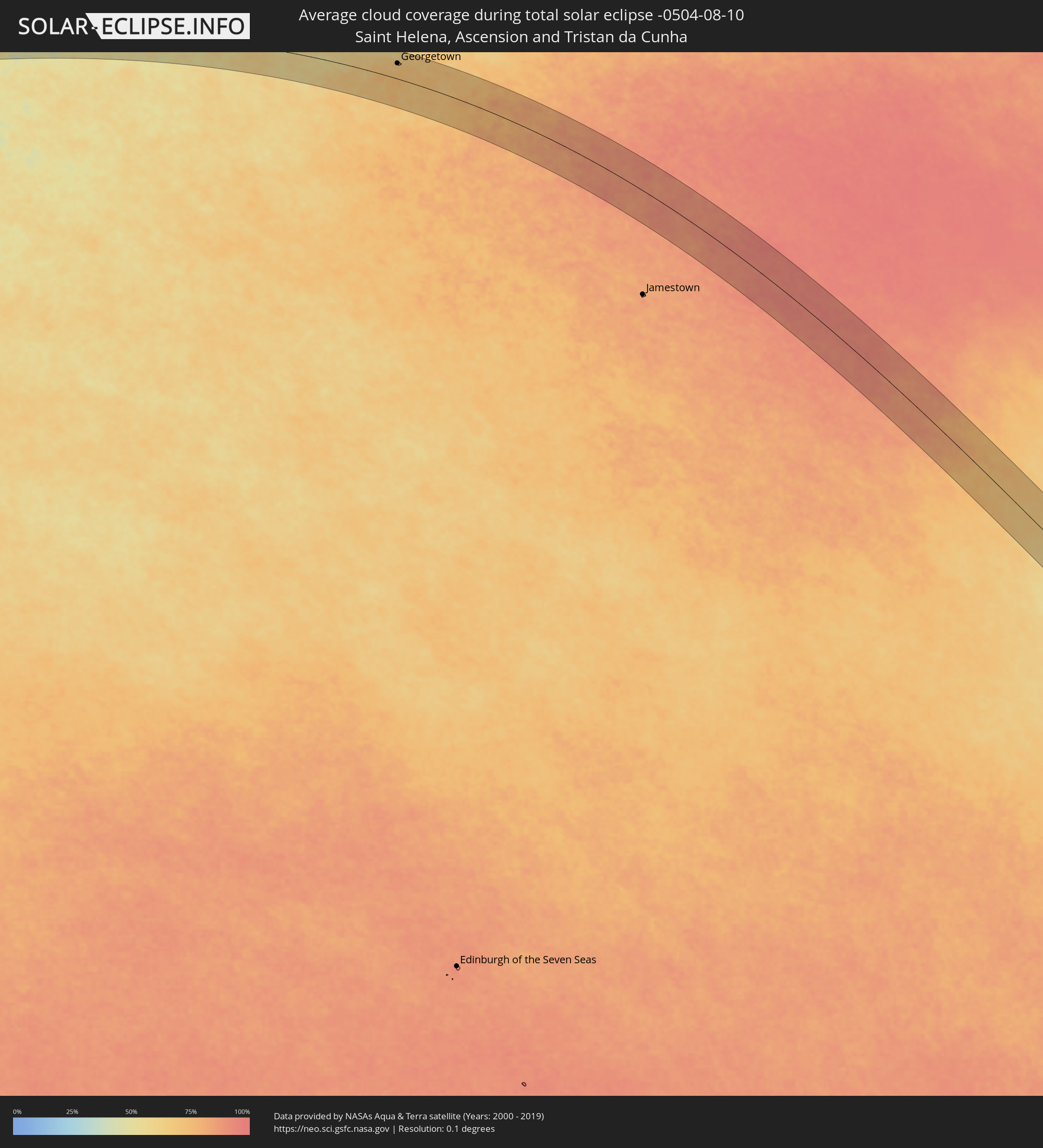 Saint Helena, Ascension and Tristan da Cunha
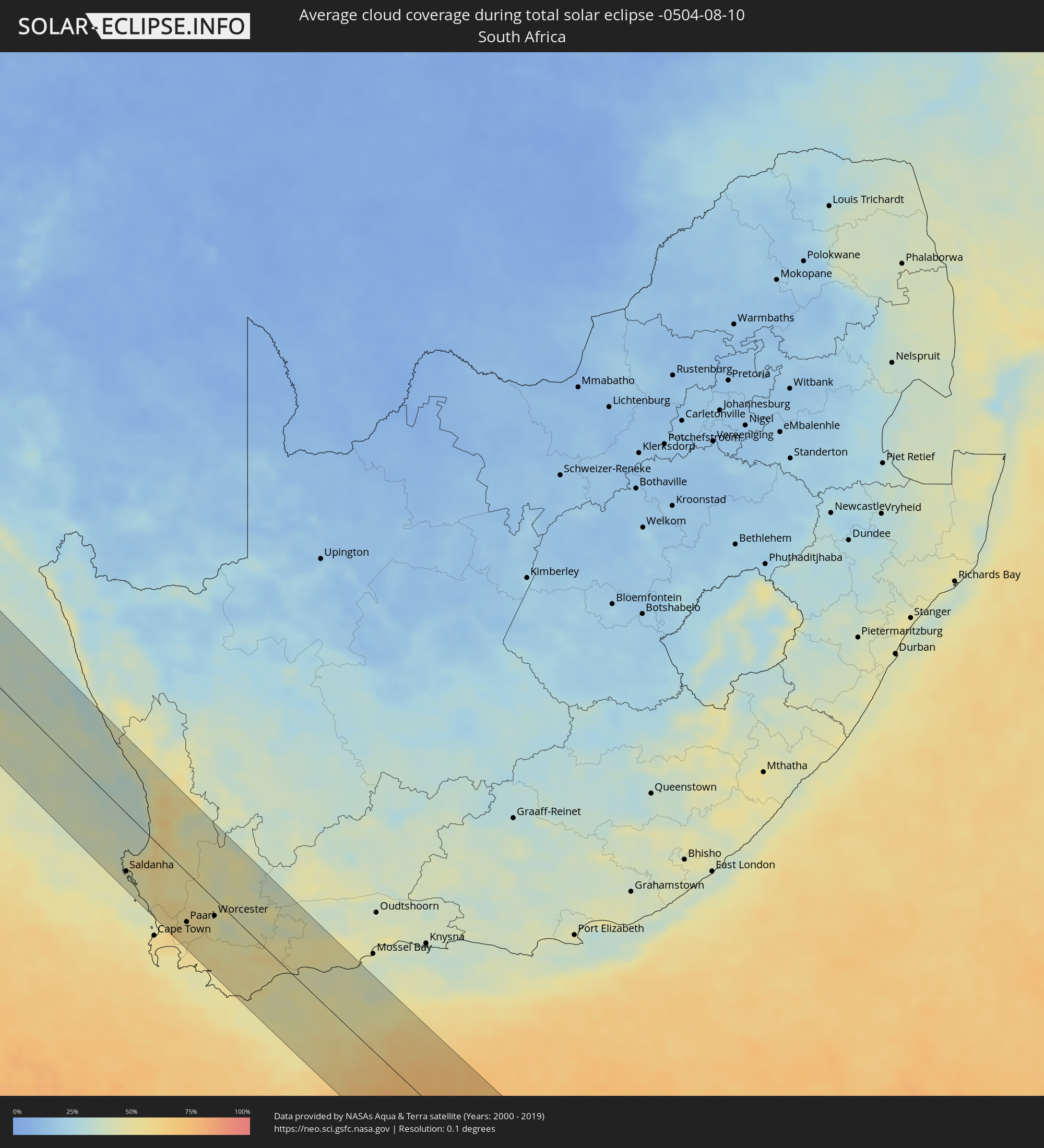 South Africa
Cities inside the path of the eclipse
The following table shows all locations with a population of more than 5,000 inside the eclipse path. Cities which have more than 100,000 inhabitants are marked bold. A click at the locations opens a detailed map.
| City | Type | Eclipse duration | Local time of max. eclipse | Distance to central line | Ø Cloud coverage |
|
Palmas, Tocantins
|
total | - | 07:21:46 UTC-02:34 | 36 km | 10% |
|
São Raimundo Nonato, Piauí
|
total | - | 07:24:15 UTC-02:34 | 3 km | 16% |
|
São João do Piauí, Piauí
|
total | - | 07:24:01 UTC-02:34 | 63 km | 13% |
|
Trindade, Pernambuco
|
total | - | 07:39:30 UTC-02:19 | 81 km | 40% |
|
Ouricuri, Pernambuco
|
total | - | 07:39:46 UTC-02:19 | 64 km | 45% |
|
Santa Maria da Boa Vista, Pernambuco
|
total | - | 07:40:49 UTC-02:19 | 43 km | 48% |
|
Cabrobó, Pernambuco
|
total | - | 07:41:01 UTC-02:19 | 22 km | 49% |
|
Salgueiro, Pernambuco
|
total | - | 07:40:48 UTC-02:19 | 22 km | 45% |
|
Brejo Santo, Ceará
|
total | - | 07:26:00 UTC-02:34 | 82 km | 38% |
|
São José do Belmonte, Pernambuco
|
total | - | 07:40:56 UTC-02:19 | 37 km | 41% |
|
Floresta, Pernambuco
|
total | - | 07:41:48 UTC-02:19 | 48 km | 52% |
|
Serra Talhada, Pernambuco
|
total | - | 07:41:30 UTC-02:19 | 13 km | 45% |
|
Custódia, Pernambuco
|
total | - | 07:42:14 UTC-02:19 | 10 km | 53% |
|
Afogados da Ingazeira, Pernambuco
|
total | - | 07:41:55 UTC-02:19 | 27 km | 47% |
|
Tabira, Pernambuco
|
total | - | 07:41:53 UTC-02:19 | 42 km | 46% |
|
São José do Egito, Pernambuco
|
total | - | 07:42:02 UTC-02:19 | 49 km | 45% |
|
Sertânia, Pernambuco
|
total | - | 07:42:36 UTC-02:19 | 16 km | 54% |
|
Buíque, Pernambuco
|
total | - | 07:43:14 UTC-02:19 | 78 km | 60% |
|
Monteiro, Paraíba
|
total | - | 07:28:10 UTC-02:34 | 1 km | 55% |
|
Arcoverde, Pernambuco
|
total | - | 07:43:08 UTC-02:19 | 58 km | 54% |
|
Pesqueira, Pernambuco
|
total | - | 07:43:27 UTC-02:19 | 58 km | 69% |
|
Belo Jardim, Pernambuco
|
total | - | 07:43:44 UTC-02:19 | 61 km | 77% |
|
Brejo da Madre de Deus, Pernambuco
|
total | - | 07:43:36 UTC-02:19 | 41 km | 68% |
|
Cachoeirinha, Pernambuco
|
total | - | 07:44:05 UTC-02:19 | 81 km | 79% |
|
Santa Cruz do Capibaribe, Pernambuco
|
total | - | 07:43:36 UTC-02:19 | 23 km | 74% |
|
Toritama, Pernambuco
|
total | - | 07:43:49 UTC-02:19 | 31 km | 74% |
|
Taquaritinga do Norte, Pernambuco
|
total | - | 07:43:44 UTC-02:19 | 20 km | 74% |
|
Caruaru, Pernambuco
|
total | - | 07:44:10 UTC-02:19 | 63 km | 77% |
|
Agrestina, Pernambuco
|
total | - | 07:44:22 UTC-02:19 | 83 km | 75% |
|
Campina Grande, Paraíba
|
total | - | 07:28:52 UTC-02:34 | 51 km | 76% |
|
Esperança, Paraíba
|
total | - | 07:28:43 UTC-02:34 | 72 km | 74% |
|
São Joaquim do Monte, Pernambuco
|
total | - | 07:44:30 UTC-02:19 | 82 km | 79% |
|
Bezerros, Pernambuco
|
total | - | 07:44:19 UTC-02:19 | 61 km | 72% |
|
Surubim, Pernambuco
|
total | - | 07:43:59 UTC-02:19 | 17 km | 74% |
|
Areia, Paraíba
|
total | - | 07:28:50 UTC-02:34 | 77 km | 79% |
|
Alagoa Grande, Paraíba
|
total | - | 07:29:05 UTC-02:34 | 55 km | 78% |
|
Bom Jardim, Pernambuco
|
total | - | 07:44:08 UTC-02:19 | 16 km | 77% |
|
Gravatá, Pernambuco
|
total | - | 07:44:32 UTC-02:19 | 61 km | 77% |
|
Guarabira, Paraíba
|
total | - | 07:28:57 UTC-02:34 | 86 km | 79% |
|
Chã Grande, Pernambuco
|
total | - | 07:44:42 UTC-02:19 | 67 km | 80% |
|
Macaparana, Pernambuco
|
total | - | 07:44:03 UTC-02:19 | 8 km | 82% |
|
Amaraji, Pernambuco
|
total | - | 07:44:51 UTC-02:19 | 83 km | 84% |
|
Limoeiro, Pernambuco
|
total | - | 07:44:21 UTC-02:19 | 27 km | 78% |
|
Pombos, Pernambuco
|
total | - | 07:44:40 UTC-02:19 | 57 km | 78% |
|
Feira Nova, Pernambuco
|
total | - | 07:44:30 UTC-02:19 | 36 km | 78% |
|
Itabaiana, Paraíba
|
total | - | 07:29:34 UTC-02:34 | 31 km | 75% |
|
Mari, Paraíba
|
total | - | 07:29:20 UTC-02:34 | 60 km | 81% |
|
Timbaúba, Pernambuco
|
total | - | 07:44:09 UTC-02:19 | 11 km | 82% |
|
Glória do Goitá, Pernambuco
|
total | - | 07:44:39 UTC-02:19 | 44 km | 80% |
|
Vitória de Santo Antão, Pernambuco
|
total | - | 07:44:46 UTC-02:19 | 56 km | 81% |
|
Lagoa do Itaenga, Pernambuco
|
total | - | 07:44:36 UTC-02:19 | 36 km | 76% |
|
Carpina, Pernambuco
|
total | - | 07:44:33 UTC-02:19 | 28 km | 76% |
|
Escada, Pernambuco
|
total | - | 07:45:05 UTC-02:19 | 84 km | 81% |
|
Mamanguape, Paraíba
|
total | - | 07:29:21 UTC-02:34 | 82 km | 77% |
|
Pedras de Fogo, Paraíba
|
total | - | 07:29:53 UTC-02:34 | 19 km | 81% |
|
Araçoiaba, Pernambuco
|
total | - | 07:44:41 UTC-02:19 | 24 km | 78% |
|
São Lourenço da Mata, Pernambuco
|
total | - | 07:44:58 UTC-02:19 | 48 km | 75% |
|
Goiana, Pernambuco
|
total | - | 07:44:34 UTC-02:19 | 0 km | 75% |
|
Jaboatão, Pernambuco
|
total | - | 07:45:10 UTC-02:19 | 68 km | 67% |
|
Caaporã, Paraíba
|
total | - | 07:30:14 UTC-02:34 | 4 km | 64% |
|
Conde, Paraíba
|
total | - | 07:29:59 UTC-02:34 | 32 km | 69% |
|
Igarassu, Pernambuco
|
total | - | 07:44:56 UTC-02:19 | 32 km | 68% |
|
Itapissuma, Pernambuco
|
total | - | 07:44:54 UTC-02:19 | 25 km | 68% |
|
Recife, Pernambuco
|
total | - | 07:45:11 UTC-02:19 | 56 km | 54% |
|
João Pessoa, Paraíba
|
total | - | 07:29:54 UTC-02:34 | 47 km | 69% |
|
Cabedelo, Paraíba
|
total | - | 07:29:49 UTC-02:34 | 61 km | 52% |
|
Itamaracá, Pernambuco
|
total | - | 07:44:57 UTC-02:19 | 23 km | 50% |
|
Georgetown, Ascension
|
total | - | 10:24:28 UTC-00:16 | 58 km | 72% |
|
Saldanha, Western Cape
|
total | - | 13:51:37 UTC+01:30 | 66 km | 43% |
|
Atlantis, Western Cape
|
total | - | 13:52:41 UTC+01:30 | 75 km | 51% |
|
Vredendal, Western Cape
|
total | - | 13:51:41 UTC+01:30 | 77 km | 53% |
|
Kraaifontein, Western Cape
|
total | - | 13:53:09 UTC+01:30 | 82 km | 62% |
|
Malmesbury, Western Cape
|
total | - | 13:52:59 UTC+01:30 | 51 km | 58% |
|
Stellenbosch, Western Cape
|
total | - | 13:53:24 UTC+01:30 | 79 km | 56% |
|
Paarl, Western Cape
|
total | - | 13:53:28 UTC+01:30 | 56 km | 53% |
|
Ceres, Western Cape
|
total | - | 13:53:46 UTC+01:30 | 5 km | 53% |
|
Worcester, Western Cape
|
total | - | 13:54:05 UTC+01:30 | 19 km | 47% |
|
Bredasdorp, Western Cape
|
total | - | 13:55:17 UTC+01:30 | 51 km | 54% |
|
Swellendam, Western Cape
|
total | - | 13:55:37 UTC+01:30 | 15 km | 50% |
|
Hardys Memories of Africa, Western Cape
|
total | - | 13:55:57 UTC+01:30 | 42 km | 46% |
|
Riversdale, Western Cape
|
total | - | 13:56:45 UTC+01:30 | 61 km | 50% |
|
Albertina, Western Cape
|
total | - | 13:57:13 UTC+01:30 | 73 km | 47% |