Annular solar eclipse of 01/26/-0513
| Day of week: | Monday |
| Maximum duration of eclipse: | 06m38s |
| Maximum width of eclipse path: | 291 km |
| Saros cycle: | 42 |
| Coverage: | 94.5% |
| Magnitude: | 0.9452 |
| Gamma: | 0.7217 |
Wo kann man die Sonnenfinsternis vom 01/26/-0513 sehen?
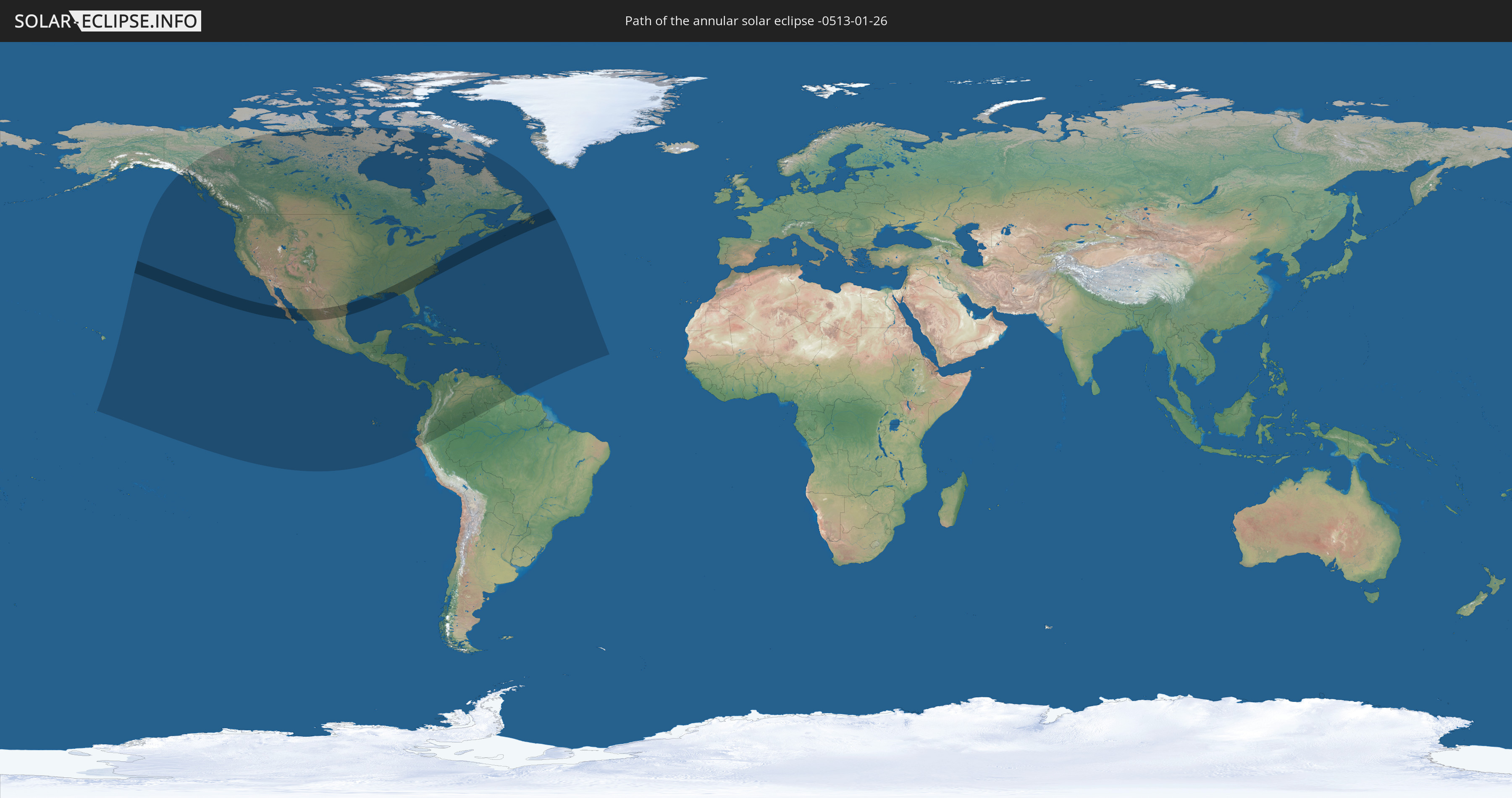
Die Sonnenfinsternis am 01/26/-0513 kann man in 46 Ländern als partielle Sonnenfinsternis beobachten.
Der Finsternispfad verläuft durch 4 Länder. Nur in diesen Ländern ist sie als annular Sonnenfinsternis zu sehen.
In den folgenden Ländern ist die Sonnenfinsternis annular zu sehen
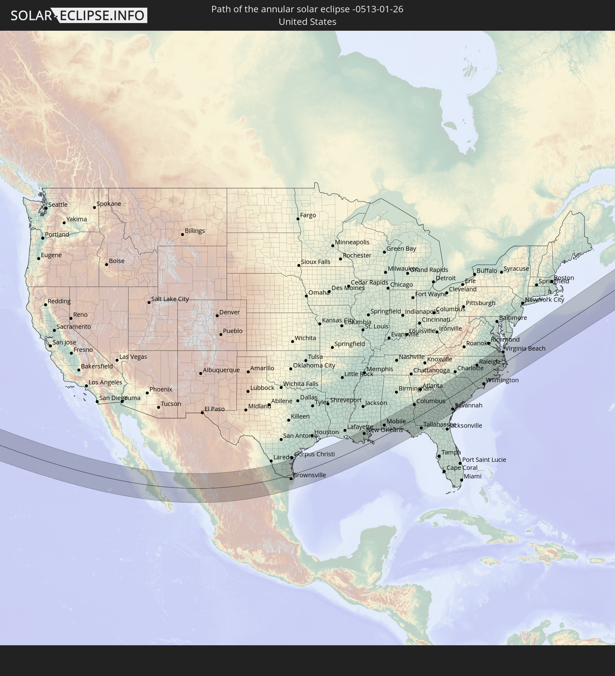 United States
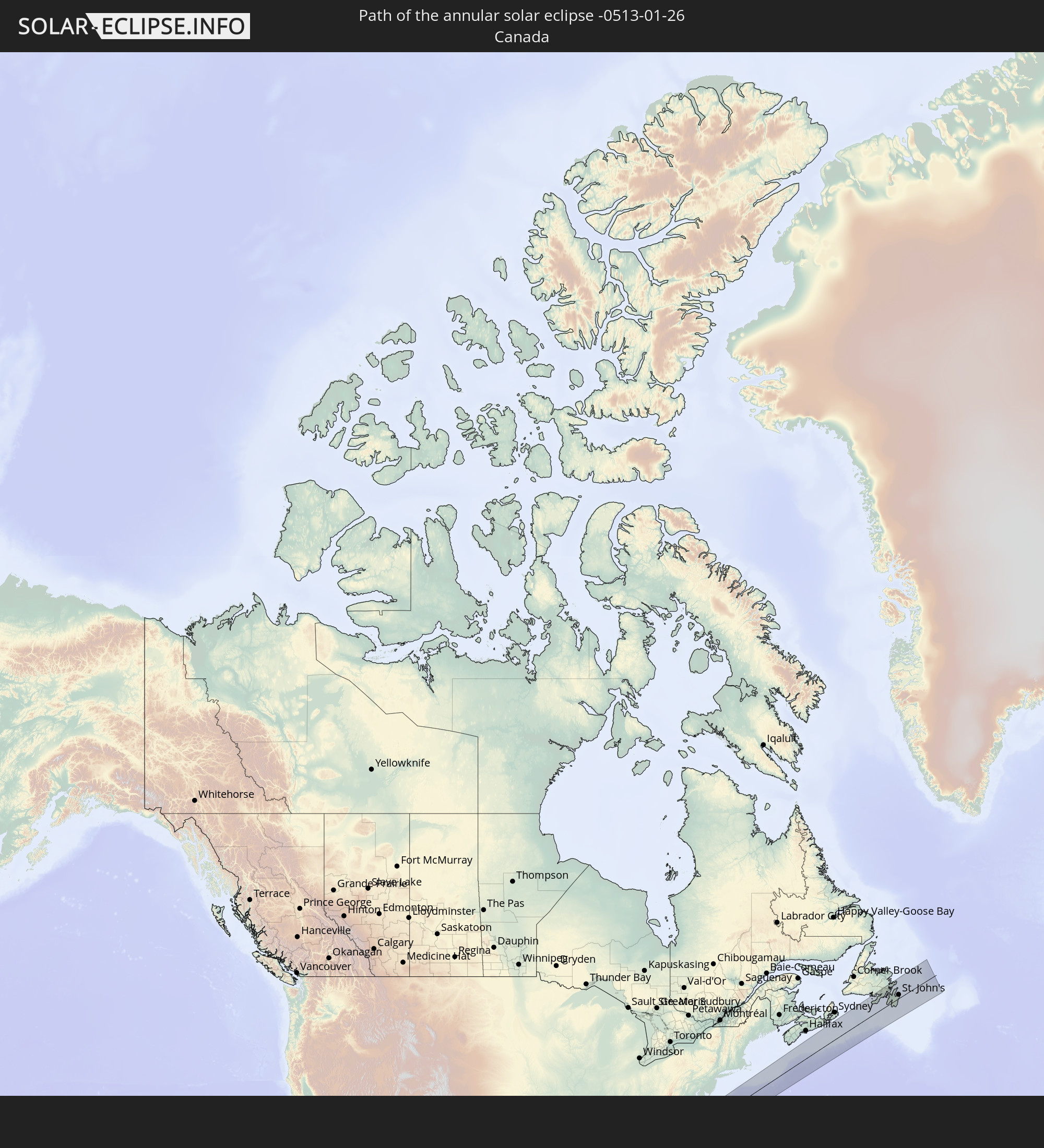 Canada
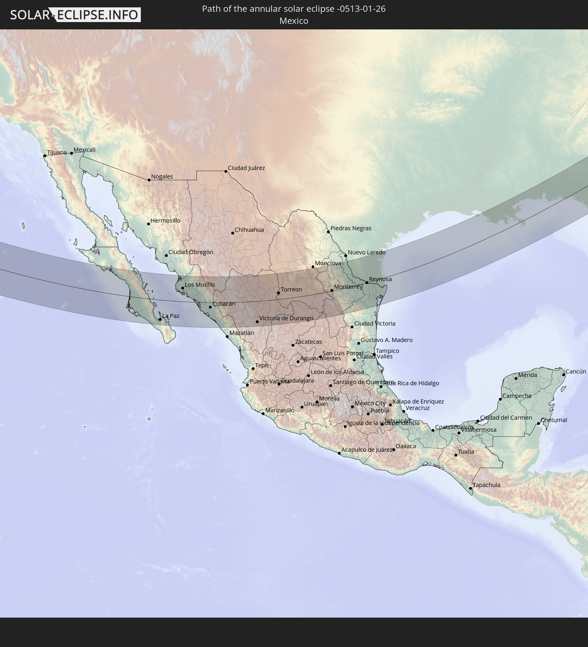 Mexico
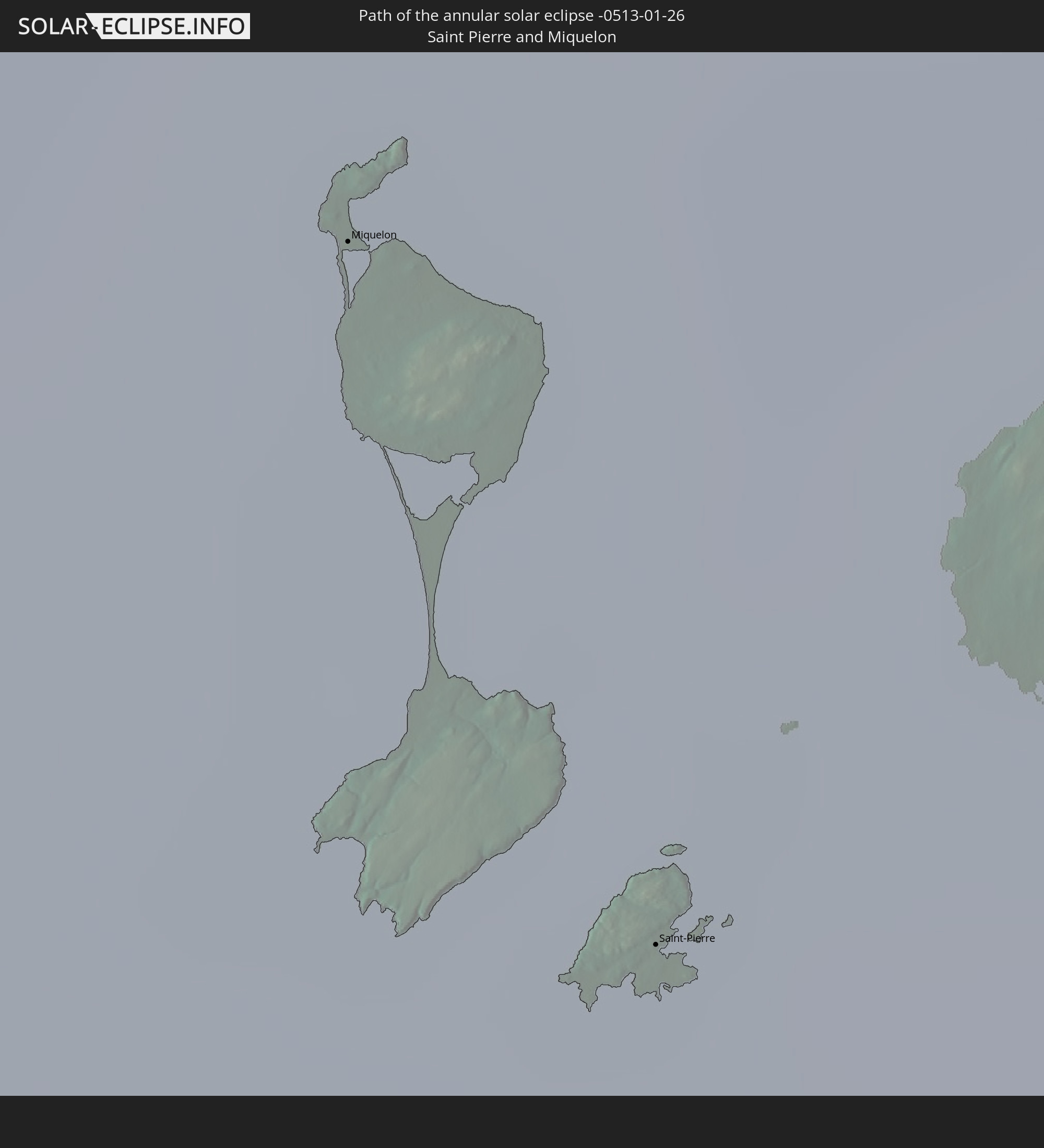 Saint Pierre and Miquelon
In den folgenden Ländern ist die Sonnenfinsternis partiell zu sehen
 United States
 United States Minor Outlying Islands
 Canada
 Mexico
 Greenland
 Guatemala
 Ecuador
 El Salvador
 Honduras
 Belize
 Nicaragua
 Costa Rica
 Cuba
Cuba
 Panama
 Colombia
 Cayman Islands
 Peru
Peru
 The Bahamas
 Jamaica
 Haiti
Haiti
 Brazil
 Venezuela
 Turks and Caicos Islands
 Dominican Republic
 Aruba
Aruba
 Puerto Rico
 United States Virgin Islands
 Bermuda
 British Virgin Islands
 Anguilla
 Collectivity of Saint Martin
 Saint Barthélemy
 Saint Kitts and Nevis
 Antigua and Barbuda
 Montserrat
 Trinidad and Tobago
 Guadeloupe
 Grenada
 Dominica
 Saint Vincent and the Grenadines
 Guyana
 Martinique
 Saint Lucia
 Barbados
 Suriname
 Saint Pierre and Miquelon
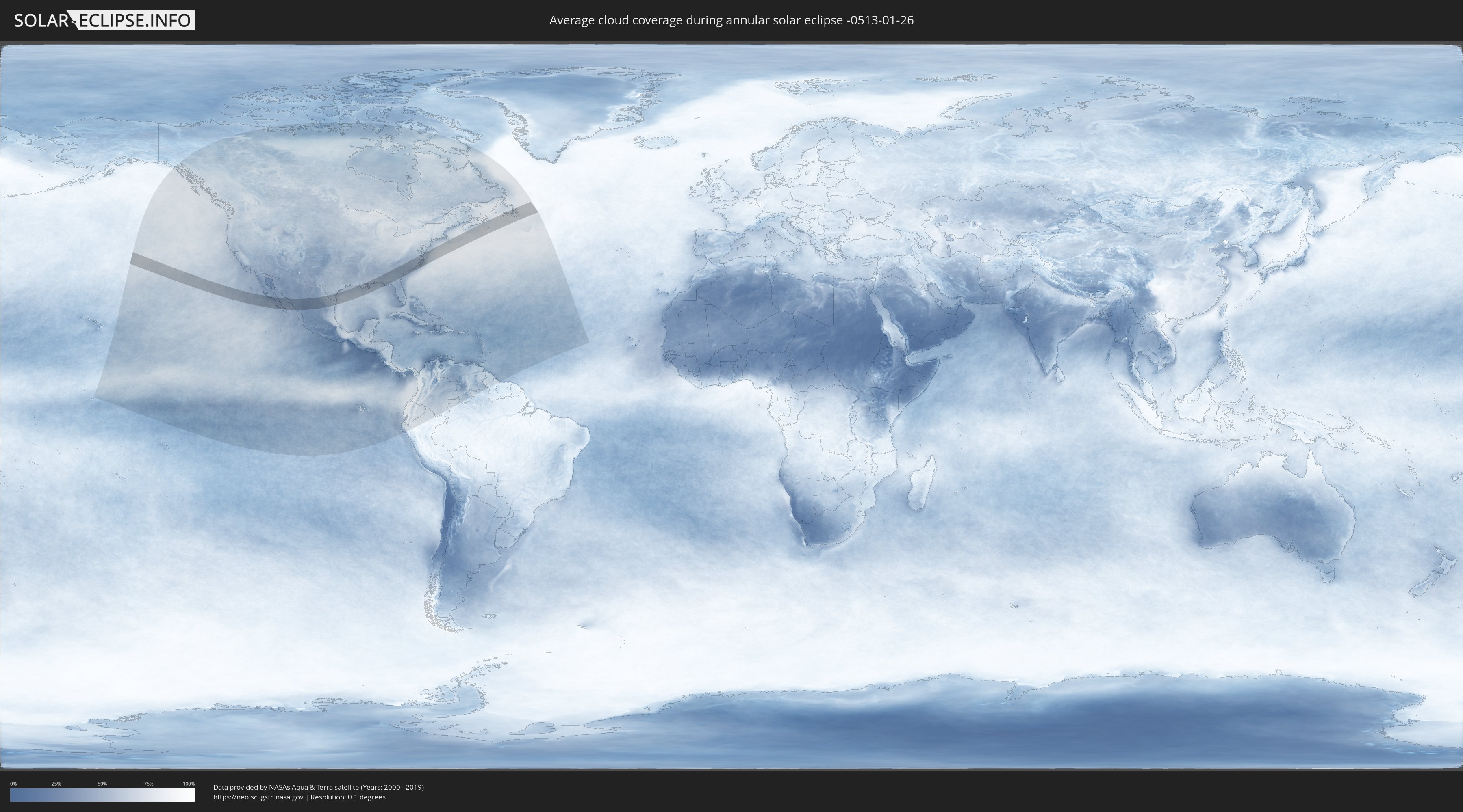
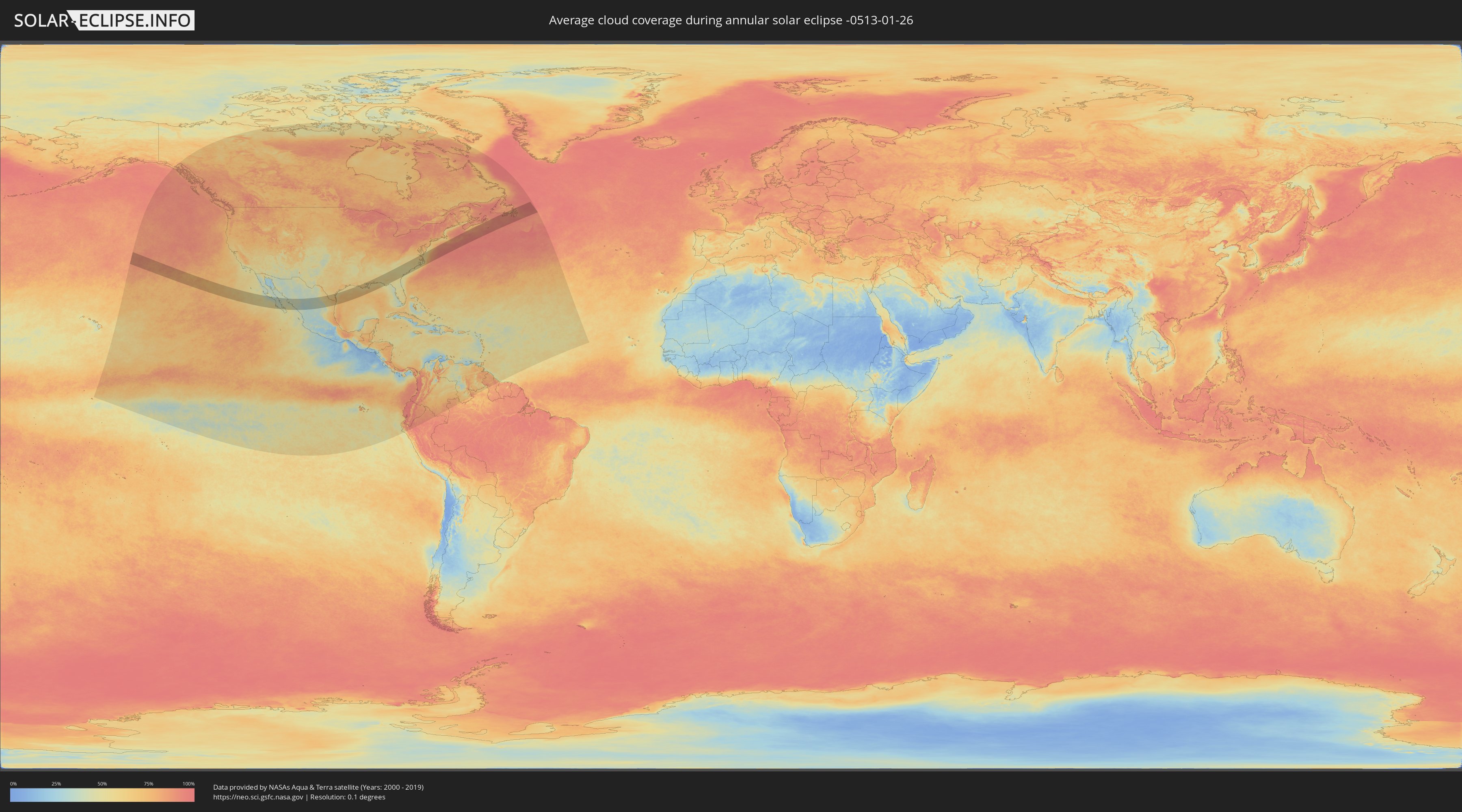
How will be the weather during the annular solar eclipse on 01/26/-0513?
Where is the best place to see the annular solar eclipse of 01/26/-0513?
The following maps show the average cloud coverage for the day of the annular solar eclipse.
With the help of these maps, it is possible to find the place along the eclipse path, which has the best
chance of a cloudless sky.
Nevertheless, you should consider local circumstances and inform about the weather of your chosen
observation site.
The data is provided by NASAs satellites
AQUA and TERRA.
The cloud maps are averaged over a period of 19 years (2000 - 2019).
Detailed country maps
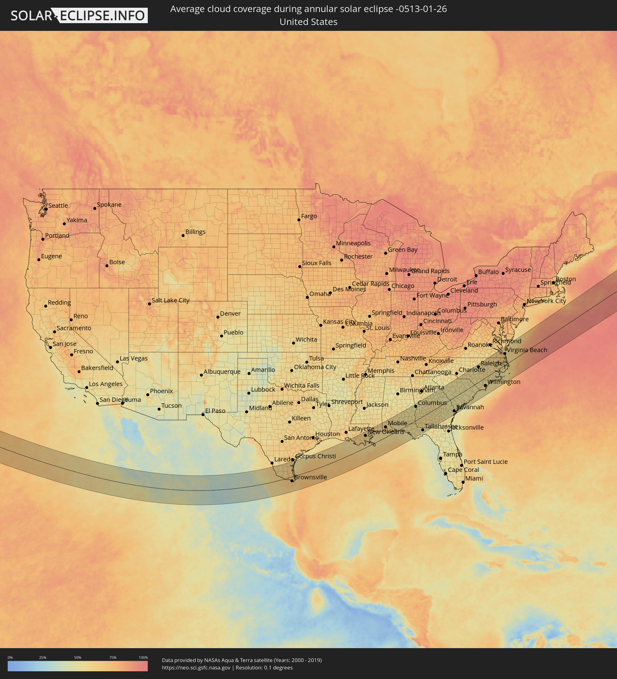 United States
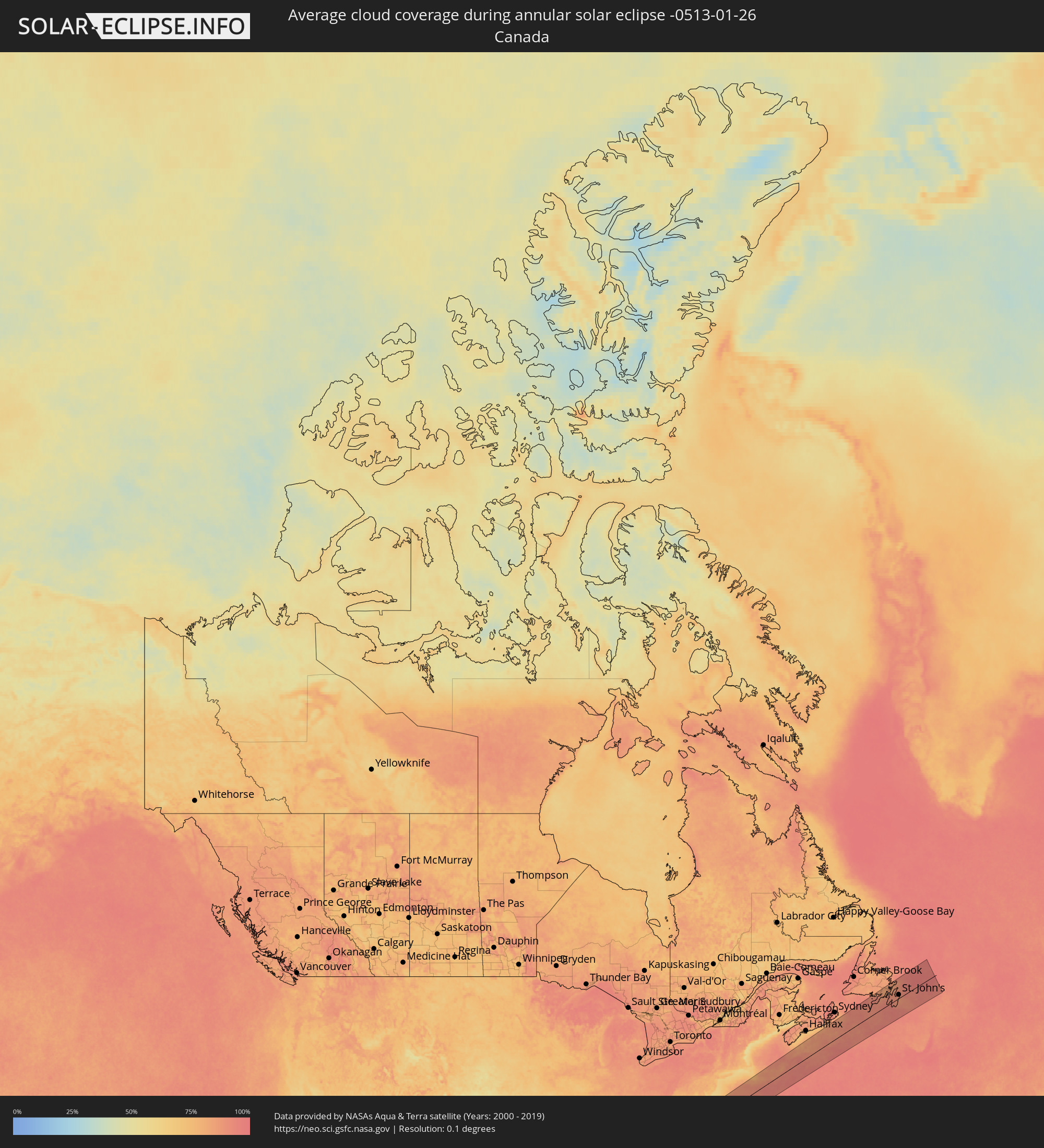 Canada
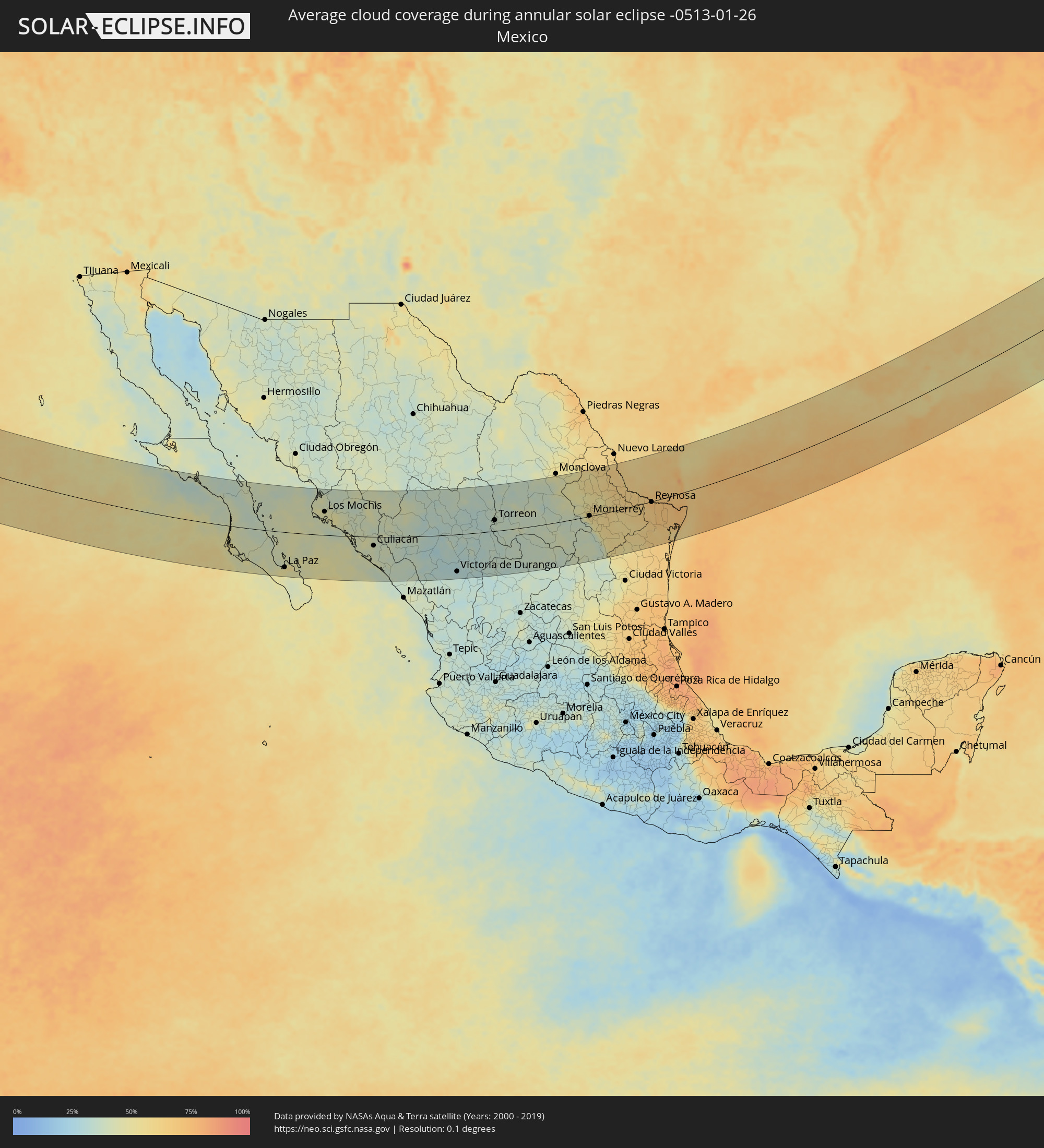 Mexico
 Saint Pierre and Miquelon
Cities inside the path of the eclipse
The following table shows all locations with a population of more than 5,000 inside the eclipse path. Cities which have more than 100,000 inhabitants are marked bold. A click at the locations opens a detailed map.
| City | Type | Eclipse duration | Local time of max. eclipse | Distance to central line | Ø Cloud coverage |
|
Ciudad Constitución, Baja California Sur
|
annular | - | 10:45:34 UTC-07:05 | 32 km | 41% |
|
Loreto, Baja California Sur
|
annular | - | 10:47:18 UTC-07:05 | 80 km | 39% |
|
La Paz, Baja California Sur
|
annular | - | 10:48:37 UTC-07:05 | 116 km | 50% |
|
Ahome, Sinaloa
|
annular | - | 10:53:24 UTC-07:05 | 90 km | 48% |
|
Los Mochis, Sinaloa
|
annular | - | 10:53:50 UTC-07:05 | 77 km | 47% |
|
Juan Jose Rios, Sinaloa
|
annular | - | 10:54:17 UTC-07:05 | 74 km | 47% |
|
Leyva Solano, Sinaloa
|
annular | - | 10:54:45 UTC-07:05 | 64 km | 48% |
|
El Fuerte de Montes Claros, Sinaloa
|
annular | - | 10:55:28 UTC-07:05 | 148 km | 38% |
|
Guasave, Sinaloa
|
annular | - | 10:55:11 UTC-07:05 | 54 km | 45% |
|
Guamúchil, Sinaloa
|
annular | - | 10:56:15 UTC-07:05 | 44 km | 39% |
|
Navolato, Sinaloa
|
annular | - | 10:56:48 UTC-07:05 | 33 km | 45% |
|
Licenciado Benito Juárez (Campo Gobierno), Sinaloa
|
annular | - | 10:57:11 UTC-07:05 | 44 km | 42% |
|
Villa de Costa Rica, Sinaloa
|
annular | - | 10:57:36 UTC-07:05 | 51 km | 41% |
|
Culiacán, Sinaloa
|
annular | - | 10:57:46 UTC-07:05 | 29 km | 41% |
|
El Dorado, Sinaloa
|
annular | - | 10:57:27 UTC-07:05 | 81 km | 42% |
|
El Rosario, Sinaloa
|
annular | - | 10:57:57 UTC-07:05 | 89 km | 42% |
|
La Cruz, Sinaloa
|
annular | - | 10:58:34 UTC-07:05 | 126 km | 38% |
|
Santiago Papasquiaro, Durango
|
annular | - | 11:33:07 UTC-06:36 | 4 km | 31% |
|
San Miguel de Papasquiaro, Durango
|
annular | - | 11:33:12 UTC-06:36 | 29 km | 30% |
|
Canatlán, Durango
|
annular | - | 11:34:44 UTC-06:36 | 66 km | 30% |
|
Victoria de Durango, Durango
|
annular | - | 11:34:42 UTC-06:36 | 123 km | 29% |
|
Guadalupe Victoria, Durango
|
annular | - | 11:36:44 UTC-06:36 | 80 km | 30% |
|
Poanas, Durango
|
annular | - | 11:39:24 UTC-06:36 | 63 km | 35% |
|
Torreon, Coahuila
|
annular | - | 11:39:49 UTC-06:36 | 36 km | 37% |
|
Juan Aldama, Zacatecas
|
annular | - | 11:38:57 UTC-06:36 | 103 km | 36% |
|
Matamoros, Coahuila
|
annular | - | 11:40:25 UTC-06:36 | 32 km | 36% |
|
Parras de la Fuente, Coahuila
|
annular | - | 11:43:43 UTC-06:36 | 8 km | 36% |
|
Castaños, Coahuila
|
annular | - | 11:47:05 UTC-06:36 | 144 km | 46% |
|
Saltillo, Coahuila
|
annular | - | 11:47:30 UTC-06:36 | 13 km | 37% |
|
García, Nuevo León
|
annular | - | 11:49:06 UTC-06:36 | 22 km | 47% |
|
Mitras Poniente, Nuevo León
|
annular | - | 11:49:37 UTC-06:36 | 15 km | 56% |
|
Monterrey, Nuevo León
|
annular | - | 11:49:54 UTC-06:36 | 2 km | 56% |
|
Sabinas Hidalgo, Nuevo León
|
annular | - | 11:50:54 UTC-06:36 | 89 km | 57% |
|
Ciénega de Flores, Nuevo León
|
annular | - | 11:50:35 UTC-06:36 | 29 km | 56% |
|
Apodaca, Nuevo León
|
annular | - | 11:50:28 UTC-06:36 | 8 km | 59% |
|
Fraccionamiento Real Palmas, Nuevo León
|
annular | - | 11:50:34 UTC-06:36 | 23 km | 58% |
|
Santiago, Nuevo León
|
annular | - | 11:50:16 UTC-06:36 | 29 km | 48% |
|
Allende, Nuevo León
|
annular | - | 11:50:37 UTC-06:36 | 48 km | 53% |
|
Cadereyta, Nuevo León
|
annular | - | 11:50:55 UTC-06:36 | 15 km | 56% |
|
Montemorelos, Nuevo León
|
annular | - | 11:51:10 UTC-06:36 | 61 km | 57% |
|
Hidalgo, Nuevo León
|
annular | - | 11:52:17 UTC-06:36 | 7 km | 58% |
|
Linares, Nuevo León
|
annular | - | 11:51:47 UTC-06:36 | 103 km | 57% |
|
Ciudad Miguel Alemán, Tamaulipas
|
annular | - | 11:54:33 UTC-06:36 | 51 km | 62% |
|
Camargo, Tamaulipas
|
annular | - | 11:55:03 UTC-06:36 | 31 km | 64% |
|
Ciudad Díaz Ordaz, Tamaulipas
|
annular | - | 11:55:50 UTC-06:36 | 23 km | 63% |
|
Reynosa, Tamaulipas
|
annular | - | 11:56:44 UTC-06:36 | 2 km | 75% |
|
McAllen, Texas
|
annular | - | 12:33:36 UTC-06:00 | 10 km | 68% |
|
San Fernando, Tamaulipas
|
annular | - | 11:56:24 UTC-06:36 | 138 km | 66% |
|
Río Bravo, Tamaulipas
|
annular | - | 11:57:18 UTC-06:36 | 17 km | 70% |
|
Weslaco, Texas
|
annular | - | 12:34:20 UTC-06:00 | 1 km | 69% |
|
Valle Hermoso, Tamaulipas
|
annular | - | 11:58:00 UTC-06:36 | 58 km | 71% |
|
Harlingen, Texas
|
annular | - | 12:35:18 UTC-06:00 | 6 km | 70% |
|
Heroica Matamoros, Tamaulipas
|
annular | - | 11:59:08 UTC-06:36 | 44 km | 75% |
|
Brownsville, Texas
|
annular | - | 12:35:46 UTC-06:00 | 42 km | 75% |
|
Houma, Louisiana
|
annular | - | 12:58:12 UTC-06:00 | 96 km | 65% |
|
Laplace, Louisiana
|
annular | - | 12:59:01 UTC-06:00 | 133 km | 63% |
|
Kenner, Louisiana
|
annular | - | 12:59:40 UTC-06:00 | 115 km | 64% |
|
New Orleans, Louisiana
|
annular | - | 13:00:08 UTC-06:00 | 104 km | 64% |
|
West Gulfport, Mississippi
|
annular | - | 13:02:57 UTC-06:00 | 105 km | 61% |
|
Biloxi, Mississippi
|
annular | - | 13:03:32 UTC-06:00 | 95 km | 59% |
|
Mobile, Alabama
|
annular | - | 13:05:51 UTC-06:00 | 87 km | 62% |
|
East Pensacola Heights, Florida
|
annular | - | 13:08:06 UTC-06:00 | 21 km | 62% |
|
Navarre, Florida
|
annular | - | 13:08:55 UTC-06:00 | 4 km | 60% |
|
Panama City, Florida
|
annular | - | 13:12:00 UTC-06:00 | 76 km | 56% |
|
Dothan, Alabama
|
annular | - | 13:12:46 UTC-06:00 | 14 km | 57% |
|
Columbus, Georgia
|
annular | - | 14:13:48 UTC-05:00 | 114 km | 51% |
|
Tallahassee, Florida
|
annular | - | 14:15:28 UTC-05:00 | 114 km | 51% |
|
Albany, Georgia
|
annular | - | 14:15:49 UTC-05:00 | 10 km | 56% |
|
Macon, Georgia
|
annular | - | 14:17:02 UTC-05:00 | 85 km | 52% |
|
Warner Robins, Georgia
|
annular | - | 14:17:03 UTC-05:00 | 63 km | 56% |
|
Valdosta, Georgia
|
annular | - | 14:17:53 UTC-05:00 | 124 km | 51% |
|
Evans, Georgia
|
annular | - | 14:20:24 UTC-05:00 | 78 km | 50% |
|
Augusta, Georgia
|
annular | - | 14:20:45 UTC-05:00 | 64 km | 50% |
|
Statesboro, Georgia
|
annular | - | 14:21:17 UTC-05:00 | 42 km | 55% |
|
Aiken, South Carolina
|
annular | - | 14:21:18 UTC-05:00 | 60 km | 53% |
|
Hinesville, Georgia
|
annular | - | 14:21:45 UTC-05:00 | 109 km | 49% |
|
Savannah, Georgia
|
annular | - | 14:22:50 UTC-05:00 | 110 km | 53% |
|
Columbia, South Carolina
|
annular | - | 14:22:43 UTC-05:00 | 68 km | 53% |
|
Hilton Head Island, South Carolina
|
annular | - | 14:23:35 UTC-05:00 | 115 km | 50% |
|
Monroe, North Carolina
|
annular | - | 14:23:33 UTC-05:00 | 136 km | 55% |
|
Sumter, South Carolina
|
annular | - | 14:24:12 UTC-05:00 | 26 km | 52% |
|
Summerville, South Carolina
|
annular | - | 14:24:43 UTC-05:00 | 67 km | 53% |
|
Charleston, South Carolina
|
annular | - | 14:25:16 UTC-05:00 | 102 km | 57% |
|
Florence, South Carolina
|
annular | - | 14:25:21 UTC-05:00 | 24 km | 49% |
|
Fort Bragg, North Carolina
|
annular | - | 14:26:39 UTC-05:00 | 75 km | 55% |
|
Fayetteville, North Carolina
|
annular | - | 14:26:56 UTC-05:00 | 60 km | 55% |
|
Apex, North Carolina
|
annular | - | 14:26:48 UTC-05:00 | 122 km | 54% |
|
Raleigh, North Carolina
|
annular | - | 14:27:12 UTC-05:00 | 116 km | 57% |
|
Wake Forest, North Carolina
|
annular | - | 14:27:23 UTC-05:00 | 129 km | 58% |
|
Goldsboro, North Carolina
|
annular | - | 14:28:34 UTC-05:00 | 48 km | 60% |
|
Wilmington, North Carolina
|
annular | - | 14:29:00 UTC-05:00 | 63 km | 59% |
|
Wilson, North Carolina
|
annular | - | 14:28:37 UTC-05:00 | 75 km | 60% |
|
Rocky Mount, North Carolina
|
annular | - | 14:28:47 UTC-05:00 | 89 km | 58% |
|
Jacksonville, North Carolina
|
annular | - | 14:29:51 UTC-05:00 | 39 km | 57% |
|
Greenville, North Carolina
|
annular | - | 14:29:41 UTC-05:00 | 38 km | 56% |
|
New Bern, North Carolina
|
annular | - | 14:30:28 UTC-05:00 | 25 km | 55% |
|
Suffolk, Virginia
|
annular | - | 14:30:43 UTC-05:00 | 103 km | 62% |
|
Newport News, Virginia
|
annular | - | 14:30:47 UTC-05:00 | 131 km | 63% |
|
Norfolk, Virginia
|
annular | - | 14:31:13 UTC-05:00 | 100 km | 66% |
|
Virginia Beach, Virginia
|
annular | - | 14:31:46 UTC-05:00 | 85 km | 63% |
|
Miquelon, Miquelon-Langlade
|
annular | - | 16:02:50 UTC-03:44 | 133 km | 93% |
|
Saint-Pierre, Saint-Pierre
|
annular | - | 16:03:20 UTC-03:44 | 95 km | 93% |
|
Bay Roberts, Newfoundland and Labrador
|
annular | - | 16:18:15 UTC-03:30 | 52 km | 89% |
|
Carbonear, Newfoundland and Labrador
|
annular | - | 16:18:08 UTC-03:30 | 62 km | 88% |
|
Conception Bay South, Newfoundland and Labrador
|
annular | - | 16:18:33 UTC-03:30 | 32 km | 90% |
|
Mount Pearl, Newfoundland and Labrador
|
annular | - | 16:18:40 UTC-03:30 | 24 km | 88% |
|
St. John's, Newfoundland and Labrador
|
annular | - | 16:18:39 UTC-03:30 | 26 km | 89% |