Total solar eclipse of 05/31/-0538
| Day of week: | Thursday |
| Maximum duration of eclipse: | 01m55s |
| Maximum width of eclipse path: | 81 km |
| Saros cycle: | 48 |
| Coverage: | 100% |
| Magnitude: | 1.0218 |
| Gamma: | 0.3934 |
Wo kann man die Sonnenfinsternis vom 05/31/-0538 sehen?
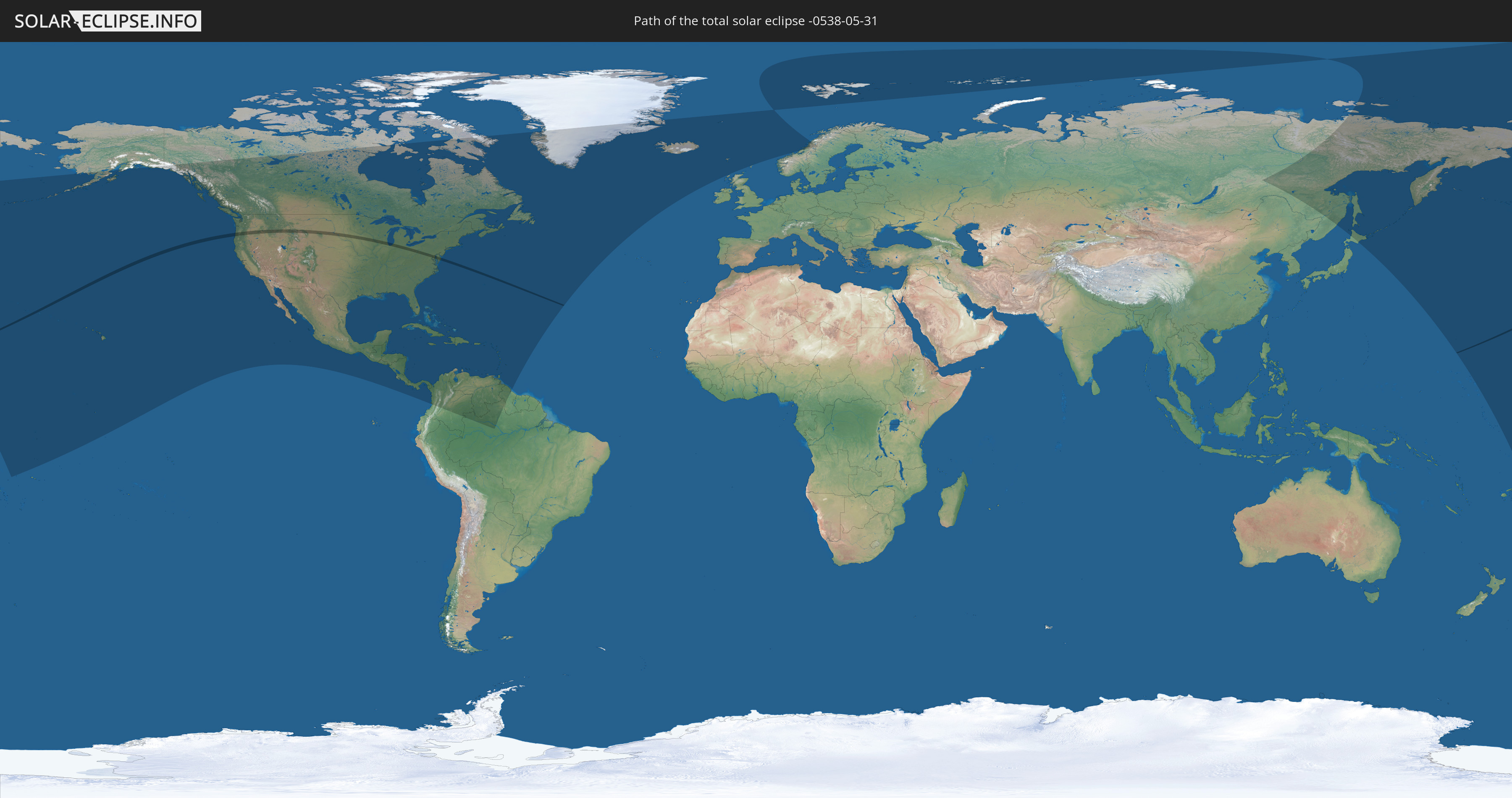
Die Sonnenfinsternis am 05/31/-0538 kann man in 54 Ländern als partielle Sonnenfinsternis beobachten.
Der Finsternispfad verläuft durch 2 Länder. Nur in diesen Ländern ist sie als total Sonnenfinsternis zu sehen.
In den folgenden Ländern ist die Sonnenfinsternis total zu sehen
 United States
 United States Minor Outlying Islands
In den folgenden Ländern ist die Sonnenfinsternis partiell zu sehen
 Russia
 United States
 United States Minor Outlying Islands
 Kiribati
 Tokelau
 Canada
 Mexico
 Greenland
 Guatemala
 El Salvador
 Honduras
 Belize
 Nicaragua
 Costa Rica
 Cuba
Cuba
 Panama
 Colombia
 Cayman Islands
 The Bahamas
 Jamaica
 Haiti
Haiti
 Brazil
 Venezuela
 Turks and Caicos Islands
 Dominican Republic
 Aruba
Aruba
 Puerto Rico
 United States Virgin Islands
 Bermuda
 British Virgin Islands
 Anguilla
 Collectivity of Saint Martin
 Saint Barthélemy
 Saint Kitts and Nevis
 Antigua and Barbuda
 Montserrat
 Trinidad and Tobago
 Guadeloupe
 Grenada
 Dominica
 Saint Vincent and the Grenadines
 Guyana
 Martinique
 Saint Lucia
 Barbados
 Saint Pierre and Miquelon
 Iceland
 Svalbard and Jan Mayen
 United Kingdom
 Faroe Islands
 Norway
 Sweden
 Japan
Japan
 Marshall Islands
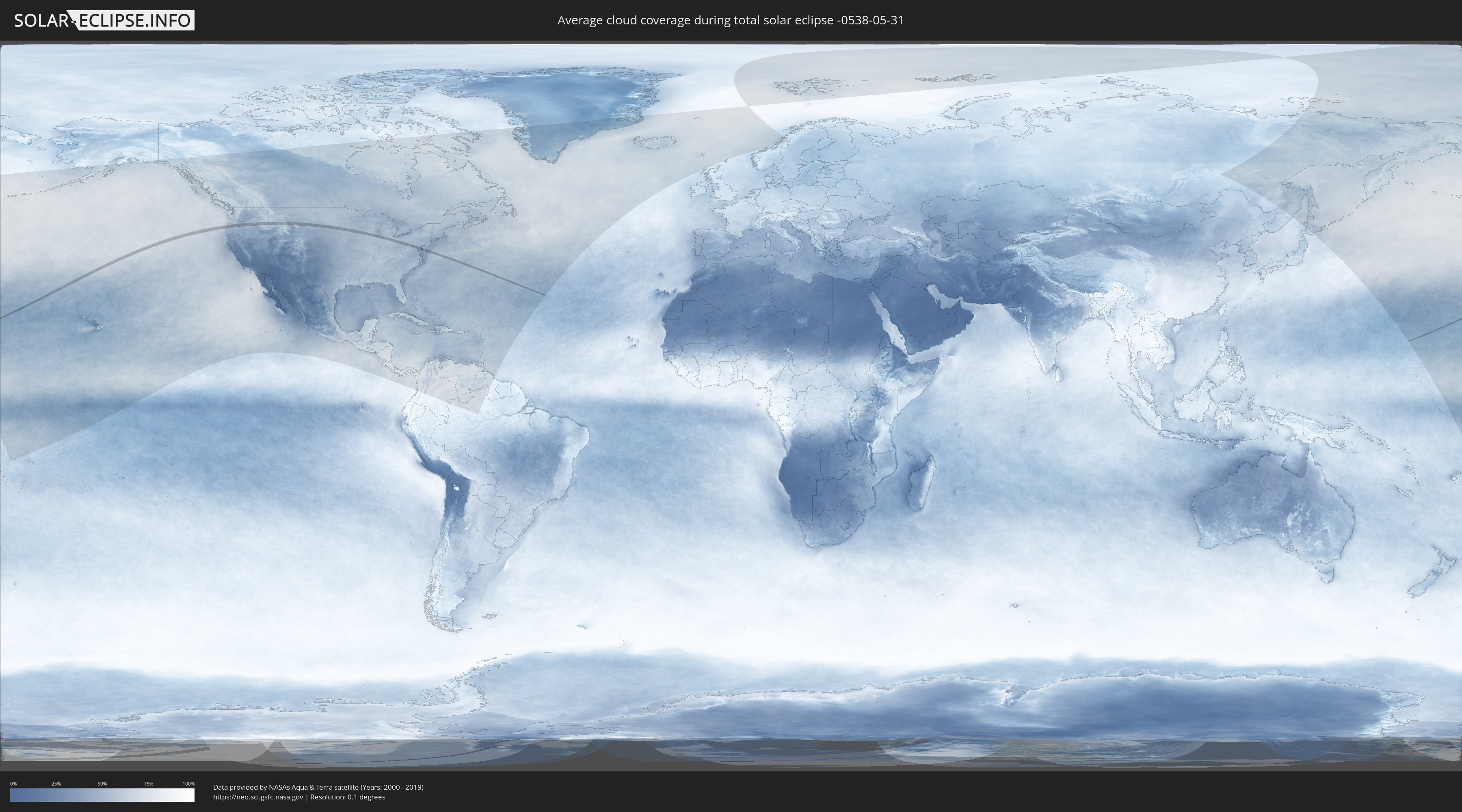
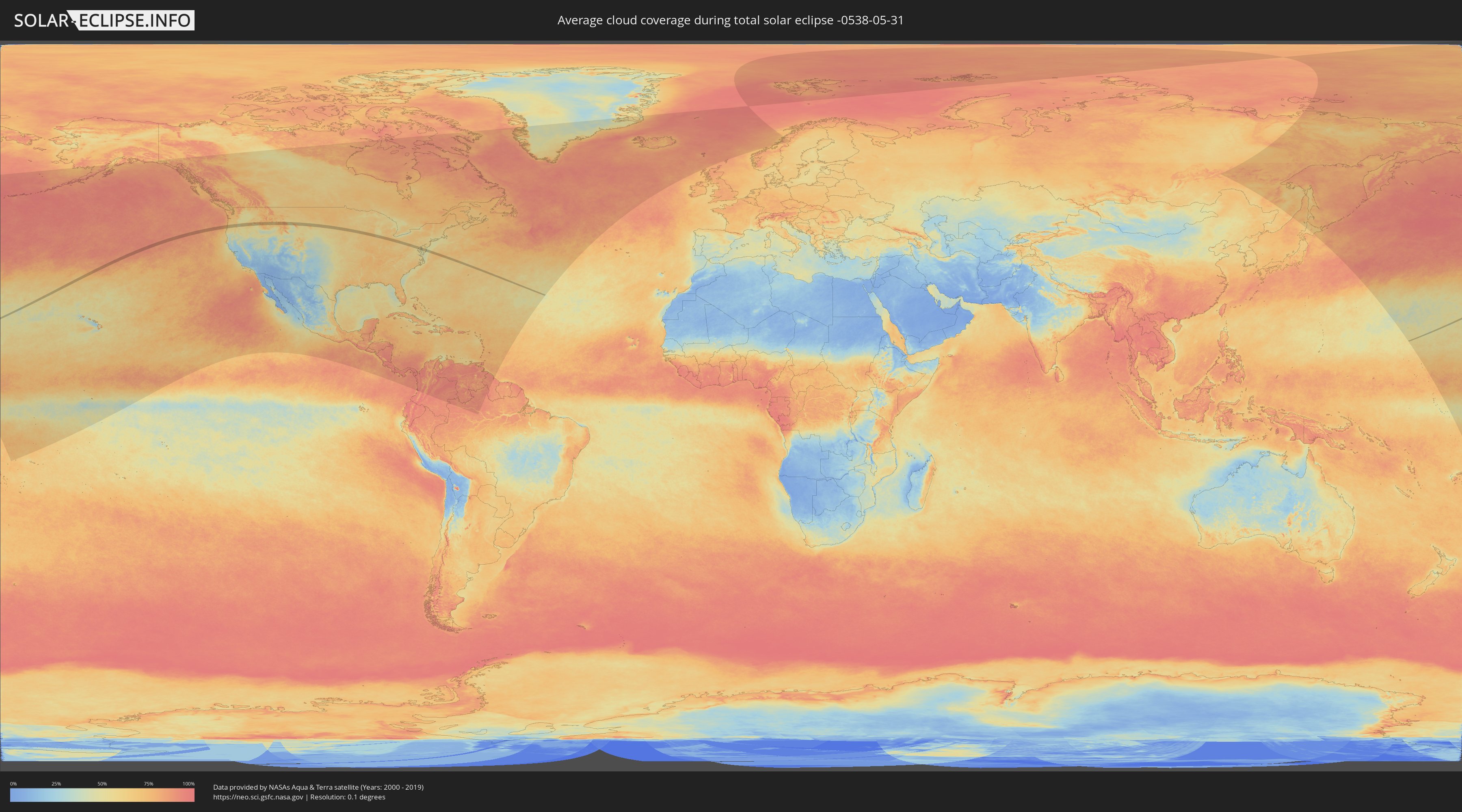
How will be the weather during the total solar eclipse on 05/31/-0538?
Where is the best place to see the total solar eclipse of 05/31/-0538?
The following maps show the average cloud coverage for the day of the total solar eclipse.
With the help of these maps, it is possible to find the place along the eclipse path, which has the best
chance of a cloudless sky.
Nevertheless, you should consider local circumstances and inform about the weather of your chosen
observation site.
The data is provided by NASAs satellites
AQUA and TERRA.
The cloud maps are averaged over a period of 19 years (2000 - 2019).
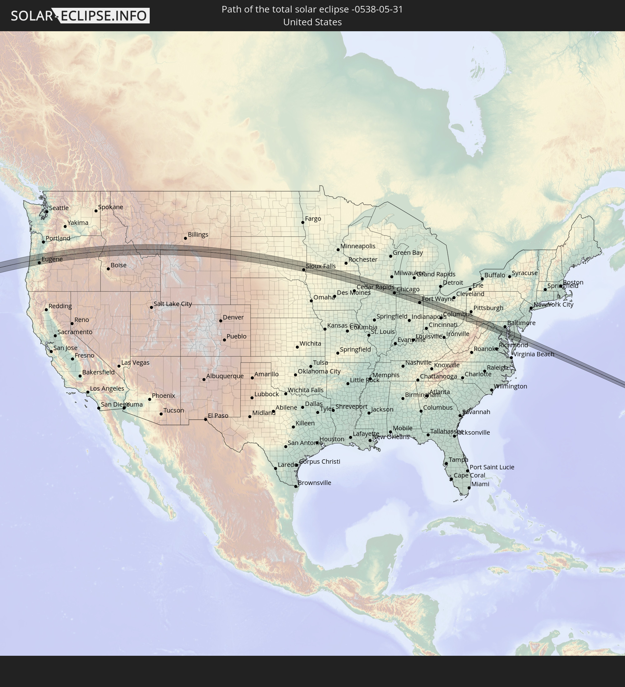
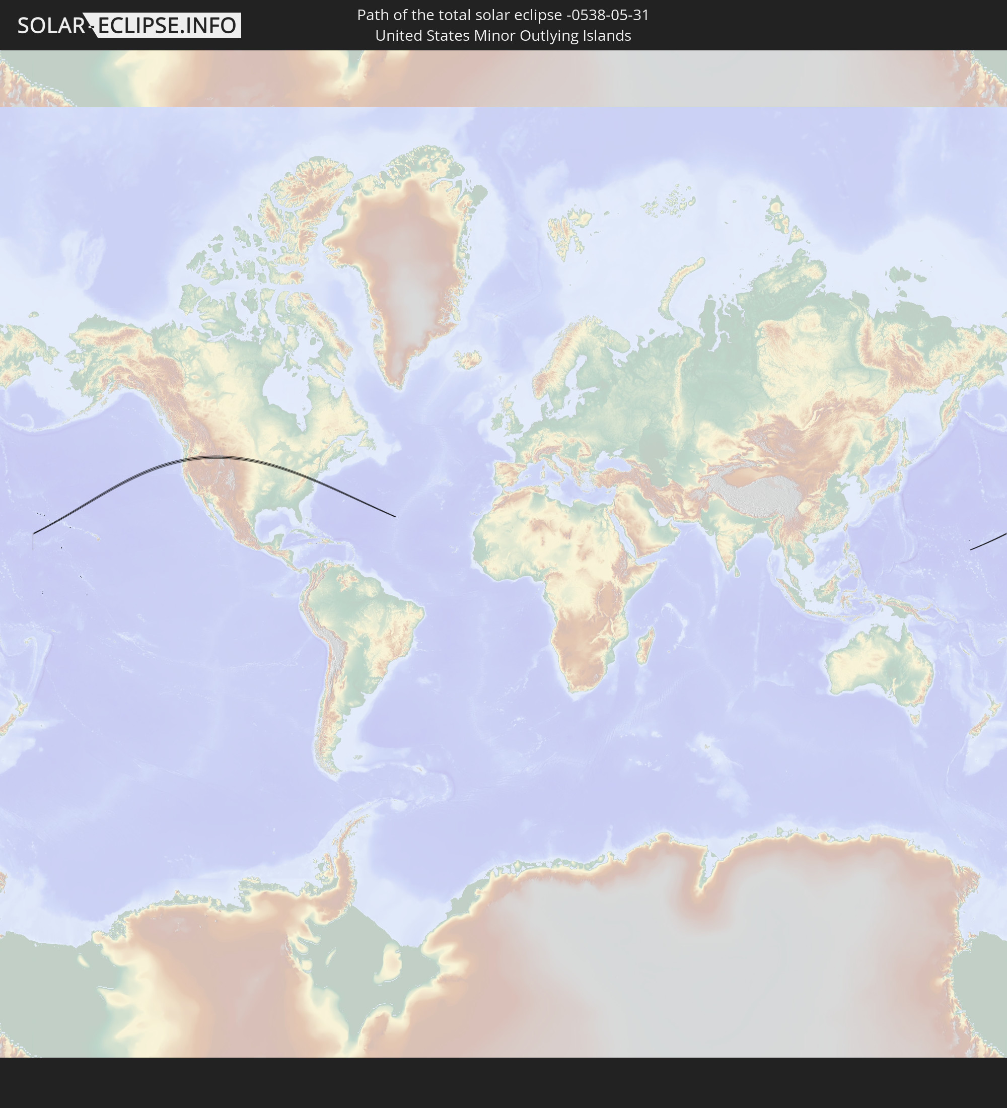
Detailed country maps
 United States
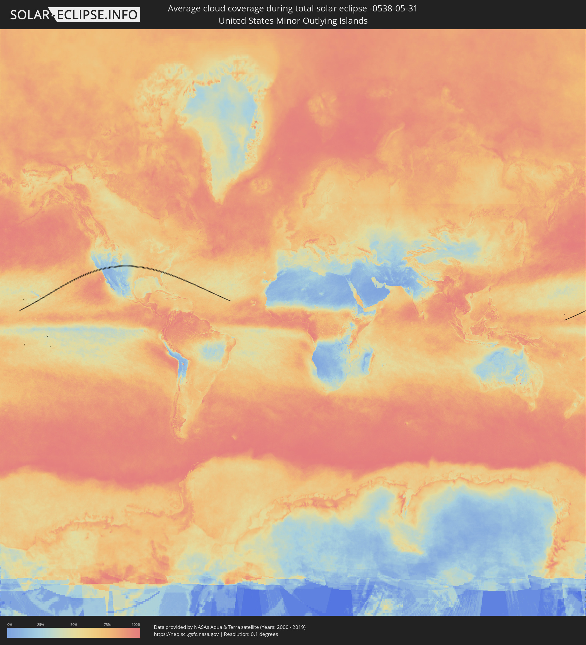 United States Minor Outlying Islands
Cities inside the path of the eclipse
The following table shows all locations with a population of more than 5,000 inside the eclipse path. Cities which have more than 100,000 inhabitants are marked bold. A click at the locations opens a detailed map.
| City | Type | Eclipse duration | Local time of max. eclipse | Distance to central line | Ø Cloud coverage |
|
Florence, Oregon
|
total | - | 12:02:23 UTC-08:00 | 24 km | 62% |
|
Corvallis, Oregon
|
total | - | 12:04:21 UTC-08:00 | 27 km | 63% |
|
Eugene, Oregon
|
total | - | 12:04:30 UTC-08:00 | 31 km | 61% |
|
Lebanon, Oregon
|
total | - | 12:05:03 UTC-08:00 | 19 km | 60% |
|
Sweet Home, Oregon
|
total | - | 12:05:21 UTC-08:00 | 2 km | 59% |
|
Redmond, Oregon
|
total | - | 12:08:30 UTC-08:00 | 32 km | 50% |
|
Prineville, Oregon
|
total | - | 12:09:12 UTC-08:00 | 32 km | 53% |
|
Baker City, Oregon
|
total | - | 12:15:22 UTC-08:00 | 7 km | 56% |
|
Sheridan, Wyoming
|
total | - | 13:36:22 UTC-07:00 | 10 km | 61% |
|
Spearfish, South Dakota
|
total | - | 13:42:04 UTC-07:00 | 20 km | 65% |
|
Pierre, South Dakota
|
total | - | 14:48:01 UTC-06:00 | 7 km | 60% |
|
Huron, South Dakota
|
total | - | 14:51:23 UTC-06:00 | 37 km | 65% |
|
Mitchell, South Dakota
|
total | - | 14:52:19 UTC-06:00 | 31 km | 61% |
|
Sioux Falls, South Dakota
|
total | - | 14:54:29 UTC-06:00 | 26 km | 63% |
|
Brandon, South Dakota
|
total | - | 14:54:38 UTC-06:00 | 19 km | 63% |
|
Worthington, Minnesota
|
total | - | 14:56:02 UTC-06:00 | 1 km | 67% |
|
Fairmont, Minnesota
|
total | - | 14:57:37 UTC-06:00 | 25 km | 66% |
|
Clear Lake, Iowa
|
total | - | 14:59:42 UTC-06:00 | 9 km | 62% |
|
Mason City, Iowa
|
total | - | 14:59:55 UTC-06:00 | 3 km | 63% |
|
Charles City, Iowa
|
total | - | 15:00:44 UTC-06:00 | 2 km | 63% |
|
Waverly, Iowa
|
total | - | 15:01:24 UTC-06:00 | 34 km | 61% |
|
Dubuque, Iowa
|
total | - | 15:04:02 UTC-06:00 | 18 km | 64% |
|
Platteville, Wisconsin
|
total | - | 15:03:59 UTC-06:00 | 11 km | 69% |
|
Monroe, Wisconsin
|
total | - | 15:05:11 UTC-06:00 | 16 km | 71% |
|
Freeport, Illinois
|
total | - | 15:05:34 UTC-06:00 | 16 km | 71% |
|
Rockford, Illinois
|
total | - | 15:06:15 UTC-06:00 | 6 km | 70% |
|
Rockton, Illinois
|
total | - | 15:06:03 UTC-06:00 | 14 km | 69% |
|
South Beloit, Illinois
|
total | - | 15:06:02 UTC-06:00 | 19 km | 69% |
|
Beloit, Wisconsin
|
total | - | 15:06:01 UTC-06:00 | 21 km | 69% |
|
Roscoe, Illinois
|
total | - | 15:06:10 UTC-06:00 | 11 km | 68% |
|
Belvidere, Illinois
|
total | - | 15:06:33 UTC-06:00 | 1 km | 67% |
|
DeKalb, Illinois
|
total | - | 15:07:05 UTC-06:00 | 34 km | 69% |
|
Harvard, Illinois
|
total | - | 15:06:38 UTC-06:00 | 22 km | 69% |
|
Marengo, Illinois
|
total | - | 15:06:51 UTC-06:00 | 4 km | 67% |
|
Crystal Lake, Illinois
|
total | - | 15:07:12 UTC-06:00 | 10 km | 66% |
|
Batavia, Illinois
|
total | - | 15:07:42 UTC-06:00 | 31 km | 70% |
|
West Dundee, Illinois
|
total | - | 15:07:25 UTC-06:00 | 4 km | 67% |
|
Elgin, Illinois
|
total | - | 15:07:30 UTC-06:00 | 11 km | 70% |
|
Island Lake, Illinois
|
total | - | 15:07:18 UTC-06:00 | 17 km | 65% |
|
Fox Lake, Illinois
|
total | - | 15:07:10 UTC-06:00 | 30 km | 67% |
|
Winfield, Illinois
|
total | - | 15:07:52 UTC-06:00 | 26 km | 71% |
|
Naperville, Illinois
|
total | - | 15:07:58 UTC-06:00 | 34 km | 71% |
|
Barrington, Illinois
|
total | - | 15:07:31 UTC-06:00 | 5 km | 67% |
|
Inverness, Illinois
|
total | - | 15:07:37 UTC-06:00 | 3 km | 68% |
|
Round Lake Park, Illinois
|
total | - | 15:07:20 UTC-06:00 | 28 km | 65% |
|
Lake Villa, Illinois
|
total | - | 15:07:16 UTC-06:00 | 35 km | 65% |
|
Hawthorn Woods, Illinois
|
total | - | 15:07:33 UTC-06:00 | 14 km | 68% |
|
Itasca, Illinois
|
total | - | 15:07:54 UTC-06:00 | 10 km | 71% |
|
Mundelein, Illinois
|
total | - | 15:07:32 UTC-06:00 | 20 km | 66% |
|
Long Grove, Illinois
|
total | - | 15:07:39 UTC-06:00 | 11 km | 68% |
|
Gages Lake, Illinois
|
total | - | 15:07:27 UTC-06:00 | 30 km | 65% |
|
Arlington Heights, Illinois
|
total | - | 15:07:47 UTC-06:00 | 2 km | 70% |
|
Clarendon Hills, Illinois
|
total | - | 15:08:11 UTC-06:00 | 28 km | 71% |
|
Elmhurst, Illinois
|
total | - | 15:08:04 UTC-06:00 | 17 km | 72% |
|
Willowbrook, Illinois
|
total | - | 15:08:14 UTC-06:00 | 30 km | 69% |
|
Oak Brook, Illinois
|
total | - | 15:08:10 UTC-06:00 | 24 km | 69% |
|
Burr Ridge, Illinois
|
total | - | 15:08:17 UTC-06:00 | 32 km | 67% |
|
Lincolnshire, Illinois
|
total | - | 15:07:44 UTC-06:00 | 15 km | 68% |
|
Hillside, Illinois
|
total | - | 15:08:08 UTC-06:00 | 18 km | 72% |
|
Northlake, Illinois
|
total | - | 15:08:06 UTC-06:00 | 14 km | 72% |
|
Park City, Illinois
|
total | - | 15:07:34 UTC-06:00 | 32 km | 66% |
|
Schiller Park, Illinois
|
total | - | 15:08:05 UTC-06:00 | 9 km | 72% |
|
Broadview, Illinois
|
total | - | 15:08:13 UTC-06:00 | 18 km | 72% |
|
North Chicago, Illinois
|
total | - | 15:07:39 UTC-06:00 | 31 km | 63% |
|
River Grove, Illinois
|
total | - | 15:08:09 UTC-06:00 | 11 km | 71% |
|
Riverside, Illinois
|
total | - | 15:08:17 UTC-06:00 | 21 km | 70% |
|
Lyons, Illinois
|
total | - | 15:08:19 UTC-06:00 | 23 km | 70% |
|
River Forest, Illinois
|
total | - | 15:08:13 UTC-06:00 | 14 km | 71% |
|
Summit, Illinois
|
total | - | 15:08:22 UTC-06:00 | 25 km | 70% |
|
Harwood Heights, Illinois
|
total | - | 15:08:08 UTC-06:00 | 6 km | 70% |
|
Highland Park, Illinois
|
total | - | 15:07:53 UTC-06:00 | 17 km | 66% |
|
Glencoe, Illinois
|
total | - | 15:07:59 UTC-06:00 | 13 km | 69% |
|
Oak Lawn, Illinois
|
total | - | 15:08:31 UTC-06:00 | 32 km | 69% |
|
Winnetka, Illinois
|
total | - | 15:08:03 UTC-06:00 | 10 km | 65% |
|
Lincolnwood, Illinois
|
total | - | 15:08:11 UTC-06:00 | 0 km | 68% |
|
Evanston, Illinois
|
total | - | 15:08:11 UTC-06:00 | 5 km | 68% |
|
Chicago, Illinois
|
total | - | 15:08:28 UTC-06:00 | 15 km | 69% |
|
Gary, Indiana
|
total | - | 15:09:08 UTC-06:00 | 34 km | 66% |
|
Lake Station, Indiana
|
total | - | 15:09:17 UTC-06:00 | 33 km | 65% |
|
Chesterton, Indiana
|
total | - | 15:09:26 UTC-06:00 | 25 km | 65% |
|
Michigan City, Indiana
|
total | - | 15:09:30 UTC-06:00 | 10 km | 63% |
|
LaPorte, Indiana
|
total | - | 15:09:49 UTC-06:00 | 16 km | 66% |
|
Plymouth, Indiana
|
total | - | 16:10:37 UTC-05:00 | 33 km | 66% |
|
Niles, Michigan
|
total | - | 16:10:03 UTC-05:00 | 19 km | 62% |
|
South Bend, Indiana
|
total | - | 16:10:15 UTC-05:00 | 4 km | 64% |
|
Elkhart, Indiana
|
total | - | 16:10:32 UTC-05:00 | 11 km | 65% |
|
Warsaw, Indiana
|
total | - | 16:11:15 UTC-05:00 | 32 km | 68% |
|
Goshen, Indiana
|
total | - | 16:10:49 UTC-05:00 | 4 km | 66% |
|
Columbia City, Indiana
|
total | - | 16:11:44 UTC-05:00 | 31 km | 70% |
|
Kendallville, Indiana
|
total | - | 16:11:36 UTC-05:00 | 5 km | 70% |
|
Fort Wayne, Indiana
|
total | - | 16:12:09 UTC-05:00 | 24 km | 71% |
|
Auburn, Indiana
|
total | - | 16:11:55 UTC-05:00 | 3 km | 69% |
|
Angola, Indiana
|
total | - | 16:11:38 UTC-05:00 | 33 km | 68% |
|
Bryan, Ohio
|
total | - | 16:12:18 UTC-05:00 | 28 km | 71% |
|
Defiance, Ohio
|
total | - | 16:12:45 UTC-05:00 | 14 km | 67% |
|
Delphos, Ohio
|
total | - | 16:13:20 UTC-05:00 | 32 km | 70% |
|
Napoleon, Ohio
|
total | - | 16:12:50 UTC-05:00 | 31 km | 69% |
|
Findlay, Ohio
|
total | - | 16:13:46 UTC-05:00 | 8 km | 70% |
|
Kenton, Ohio
|
total | - | 16:14:19 UTC-05:00 | 32 km | 70% |
|
Fostoria, Ohio
|
total | - | 16:13:51 UTC-05:00 | 27 km | 67% |
|
Tiffin, Ohio
|
total | - | 16:14:08 UTC-05:00 | 29 km | 69% |
|
Marion, Ohio
|
total | - | 16:14:52 UTC-05:00 | 24 km | 67% |
|
Bucyrus, Ohio
|
total | - | 16:14:44 UTC-05:00 | 3 km | 66% |
|
Galion, Ohio
|
total | - | 16:15:00 UTC-05:00 | 1 km | 69% |
|
Shelby, Ohio
|
total | - | 16:14:56 UTC-05:00 | 20 km | 67% |
|
Mansfield, Ohio
|
total | - | 16:15:14 UTC-05:00 | 11 km | 65% |
|
Mount Vernon, Ohio
|
total | - | 16:15:44 UTC-05:00 | 26 km | 68% |
|
Ashland, Ohio
|
total | - | 16:15:16 UTC-05:00 | 28 km | 69% |
|
Coshocton, Ohio
|
total | - | 16:16:29 UTC-05:00 | 20 km | 63% |
|
New Philadelphia, Ohio
|
total | - | 16:16:34 UTC-05:00 | 15 km | 63% |
|
Moundsville, West Virginia
|
total | - | 16:17:56 UTC-05:00 | 23 km | 60% |
|
Martins Ferry, Ohio
|
total | - | 16:17:43 UTC-05:00 | 4 km | 59% |
|
Wheeling, West Virginia
|
total | - | 16:17:46 UTC-05:00 | 8 km | 59% |
|
Steubenville, Ohio
|
total | - | 16:17:26 UTC-05:00 | 27 km | 59% |
|
Washington, Pennsylvania
|
total | - | 16:18:02 UTC-05:00 | 18 km | 61% |
|
Canonsburg, Pennsylvania
|
total | - | 16:17:57 UTC-05:00 | 29 km | 62% |
|
Maple Glen, Pennsylvania
|
total | - | 16:18:28 UTC-05:00 | 10 km | 56% |
|
Morgantown, West Virginia
|
total | - | 16:19:00 UTC-05:00 | 29 km | 60% |
|
Monessen, Pennsylvania
|
total | - | 16:18:22 UTC-05:00 | 27 km | 56% |
|
Cheat Lake, West Virginia
|
total | - | 16:19:01 UTC-05:00 | 21 km | 61% |
|
Uniontown, Pennsylvania
|
total | - | 16:18:50 UTC-05:00 | 6 km | 63% |
|
Connellsville, Pennsylvania
|
total | - | 16:18:47 UTC-05:00 | 23 km | 61% |
|
Frostburg, Maryland
|
total | - | 16:19:47 UTC-05:00 | 6 km | 64% |
|
Cumberland, Maryland
|
total | - | 16:19:56 UTC-05:00 | 11 km | 61% |
|
Winchester, Virginia
|
total | - | 16:21:01 UTC-05:00 | 18 km | 65% |
|
Martinsburg, West Virginia
|
total | - | 16:20:48 UTC-05:00 | 16 km | 60% |
|
Purcellville, Virginia
|
total | - | 16:21:25 UTC-05:00 | 9 km | 58% |
|
Brambleton, Virginia
|
total | - | 16:21:45 UTC-05:00 | 19 km | 61% |
|
Broadlands, Virginia
|
total | - | 16:21:43 UTC-05:00 | 15 km | 61% |
|
Ashburn, Virginia
|
total | - | 16:21:42 UTC-05:00 | 11 km | 61% |
|
Centreville, Virginia
|
total | - | 16:22:01 UTC-05:00 | 30 km | 55% |
|
Countryside, Virginia
|
total | - | 16:21:46 UTC-05:00 | 9 km | 63% |
|
Floris, Virginia
|
total | - | 16:21:54 UTC-05:00 | 20 km | 59% |
|
Frederick, Maryland
|
total | - | 16:21:16 UTC-05:00 | 30 km | 61% |
|
Greenbriar, Virginia
|
total | - | 16:22:00 UTC-05:00 | 26 km | 59% |
|
Sugarland Run, Virginia
|
total | - | 16:21:48 UTC-05:00 | 8 km | 63% |
|
Lowes Island, Virginia
|
total | - | 16:21:47 UTC-05:00 | 5 km | 56% |
|
Urbana, Maryland
|
total | - | 16:21:26 UTC-05:00 | 22 km | 58% |
|
Dranesville, Virginia
|
total | - | 16:21:52 UTC-05:00 | 11 km | 57% |
|
Reston, Virginia
|
total | - | 16:21:55 UTC-05:00 | 14 km | 57% |
|
Green Valley, Maryland
|
total | - | 16:21:30 UTC-05:00 | 22 km | 58% |
|
Germantown, Maryland
|
total | - | 16:21:42 UTC-05:00 | 9 km | 56% |
|
Travilah, Maryland
|
total | - | 16:21:50 UTC-05:00 | 1 km | 53% |
|
Mantua, Virginia
|
total | - | 16:22:08 UTC-05:00 | 23 km | 59% |
|
Dunn Loring, Virginia
|
total | - | 16:22:06 UTC-05:00 | 18 km | 59% |
|
North Springfield, Virginia
|
total | - | 16:22:14 UTC-05:00 | 27 km | 55% |
|
Annandale, Virginia
|
total | - | 16:22:12 UTC-05:00 | 24 km | 55% |
|
Falls Church, Virginia
|
total | - | 16:22:09 UTC-05:00 | 17 km | 59% |
|
Lake Barcroft, Virginia
|
total | - | 16:22:13 UTC-05:00 | 20 km | 55% |
|
Seven Corners, Virginia
|
total | - | 16:22:11 UTC-05:00 | 18 km | 59% |
|
South Kensington, Maryland
|
total | - | 16:22:02 UTC-05:00 | 0 km | 61% |
|
Aspen Hill, Maryland
|
total | - | 16:21:58 UTC-05:00 | 6 km | 61% |
|
North Kensington, Maryland
|
total | - | 16:22:02 UTC-05:00 | 1 km | 61% |
|
Chevy Chase, Maryland
|
total | - | 16:22:04 UTC-05:00 | 2 km | 61% |
|
Rossmoor, Maryland
|
total | - | 16:21:56 UTC-05:00 | 9 km | 61% |
|
Huntington, Virginia
|
total | - | 16:22:21 UTC-05:00 | 23 km | 54% |
|
Leisure World, Maryland
|
total | - | 16:21:56 UTC-05:00 | 9 km | 61% |
|
Washington, D.C., Washington, D.C.
|
total | - | 16:22:14 UTC-05:00 | 12 km | 60% |
|
Kemp Mill, Maryland
|
total | - | 16:22:03 UTC-05:00 | 4 km | 60% |
|
Four Corners, Maryland
|
total | - | 16:22:05 UTC-05:00 | 2 km | 60% |
|
Friendly, Maryland
|
total | - | 16:22:28 UTC-05:00 | 25 km | 56% |
|
Mount Rainier, Maryland
|
total | - | 16:22:13 UTC-05:00 | 5 km | 60% |
|
Temple Hills, Maryland
|
total | - | 16:22:24 UTC-05:00 | 17 km | 58% |
|
Bladensburg, Maryland
|
total | - | 16:22:15 UTC-05:00 | 4 km | 61% |
|
Burtonsville, Maryland
|
total | - | 16:22:01 UTC-05:00 | 14 km | 60% |
|
Riverdale Park, Maryland
|
total | - | 16:22:13 UTC-05:00 | 1 km | 62% |
|
Coral Hills, Maryland
|
total | - | 16:22:21 UTC-05:00 | 10 km | 61% |
|
Clinton, Maryland
|
total | - | 16:22:30 UTC-05:00 | 21 km | 58% |
|
Walker Mill, Maryland
|
total | - | 16:22:22 UTC-05:00 | 9 km | 61% |
|
New Carrollton, Maryland
|
total | - | 16:22:15 UTC-05:00 | 1 km | 62% |
|
Forestville, Maryland
|
total | - | 16:22:25 UTC-05:00 | 12 km | 58% |
|
Lanham, Maryland
|
total | - | 16:22:16 UTC-05:00 | 2 km | 62% |
|
South Laurel, Maryland
|
total | - | 16:22:08 UTC-05:00 | 12 km | 60% |
|
Columbia, Maryland
|
total | - | 16:21:55 UTC-05:00 | 30 km | 61% |
|
Largo, Maryland
|
total | - | 16:22:23 UTC-05:00 | 5 km | 60% |
|
Lake Arbor, Maryland
|
total | - | 16:22:22 UTC-05:00 | 4 km | 60% |
|
Savage, Maryland
|
total | - | 16:22:04 UTC-05:00 | 20 km | 58% |
|
Kettering, Maryland
|
total | - | 16:22:24 UTC-05:00 | 5 km | 60% |
|
Westphalia, Maryland
|
total | - | 16:22:28 UTC-05:00 | 9 km | 56% |
|
Rosaryville, Maryland
|
total | - | 16:22:35 UTC-05:00 | 18 km | 56% |
|
Marlton, Maryland
|
total | - | 16:22:34 UTC-05:00 | 16 km | 56% |
|
Fort George G Mead Junction, Maryland
|
total | - | 16:22:06 UTC-05:00 | 20 km | 58% |
|
Jessup, Maryland
|
total | - | 16:22:05 UTC-05:00 | 23 km | 58% |
|
Brock Hall, Maryland
|
total | - | 16:22:29 UTC-05:00 | 7 km | 60% |
|
Fort Meade, Maryland
|
total | - | 16:22:10 UTC-05:00 | 20 km | 57% |
|
Mitchellville, Maryland
|
total | - | 16:22:24 UTC-05:00 | 1 km | 58% |
|
Bowie, Maryland
|
total | - | 16:22:23 UTC-05:00 | 3 km | 58% |
|
Davidsonville, Maryland
|
total | - | 16:22:29 UTC-05:00 | 5 km | 54% |
|
Glen Burnie, Maryland
|
total | - | 16:22:10 UTC-05:00 | 29 km | 54% |
|
Edgewater, Maryland
|
total | - | 16:22:30 UTC-05:00 | 11 km | 52% |
|
Londontowne, Maryland
|
total | - | 16:22:32 UTC-05:00 | 8 km | 53% |
|
Mayo, Maryland
|
total | - | 16:22:37 UTC-05:00 | 5 km | 53% |
|
Annapolis, Maryland
|
total | - | 16:22:30 UTC-05:00 | 15 km | 52% |
|
Cape Saint Claire, Maryland
|
total | - | 16:22:27 UTC-05:00 | 23 km | 53% |
|
Cambridge, Maryland
|
total | - | 16:23:20 UTC-05:00 | 14 km | 49% |
|
Easton, Maryland
|
total | - | 16:23:04 UTC-05:00 | 8 km | 50% |
|
Seaford, Delaware
|
total | - | 16:23:33 UTC-05:00 | 10 km | 58% |
|
Salisbury, Maryland
|
total | - | 16:23:56 UTC-05:00 | 19 km | 58% |
|
Ocean Pines, Maryland
|
total | - | 16:24:10 UTC-05:00 | 1 km | 55% |
|
Ocean City, Maryland
|
total | - | 16:24:18 UTC-05:00 | 4 km | 58% |