Annular solar eclipse of 04/25/-0722
| Day of week: | Saturday |
| Maximum duration of eclipse: | 06m45s |
| Maximum width of eclipse path: | 193 km |
| Saros cycle: | 46 |
| Coverage: | 94.8% |
| Magnitude: | 0.9475 |
| Gamma: | 0.0391 |
Wo kann man die Sonnenfinsternis vom 04/25/-0722 sehen?

Die Sonnenfinsternis am 04/25/-0722 kann man in 102 Ländern als partielle Sonnenfinsternis beobachten.
Der Finsternispfad verläuft durch 15 Länder. Nur in diesen Ländern ist sie als annular Sonnenfinsternis zu sehen.
In den folgenden Ländern ist die Sonnenfinsternis annular zu sehen
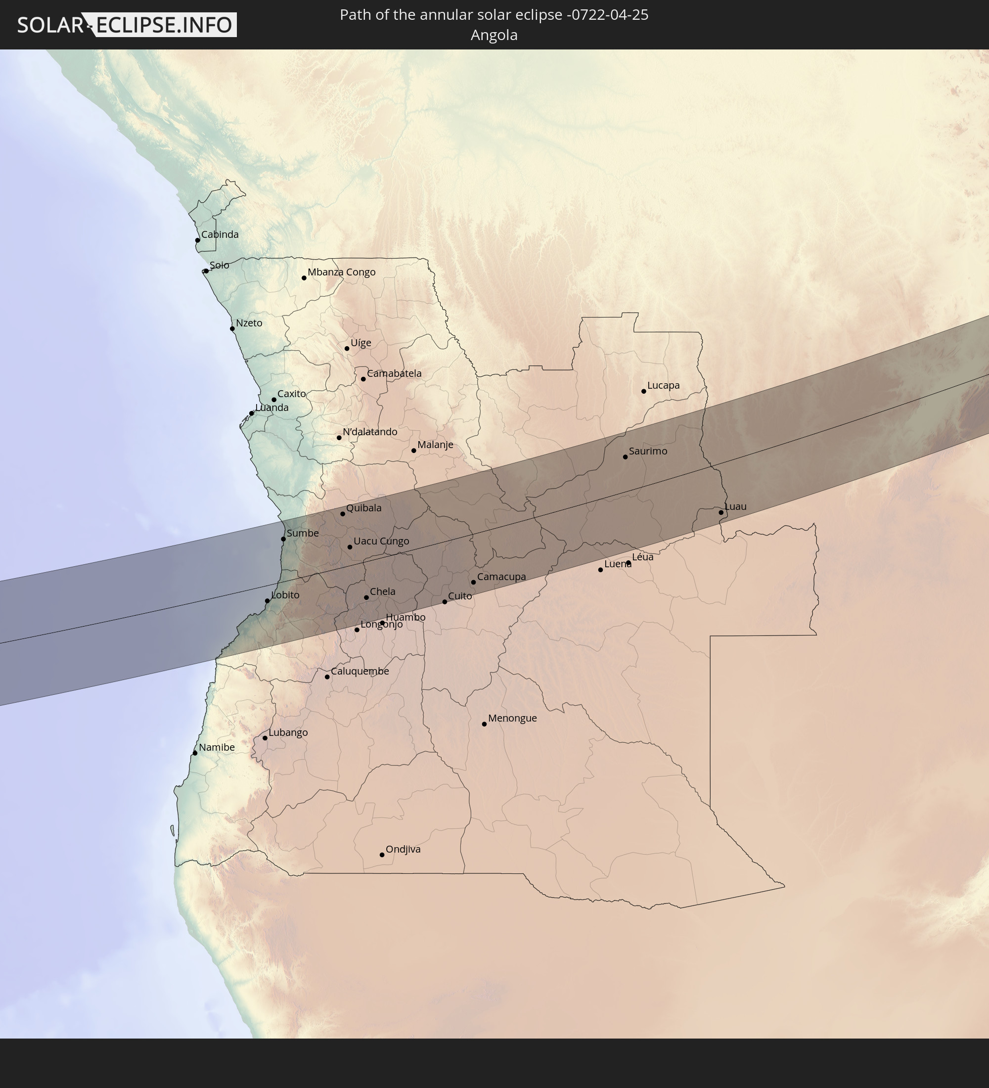 Angola
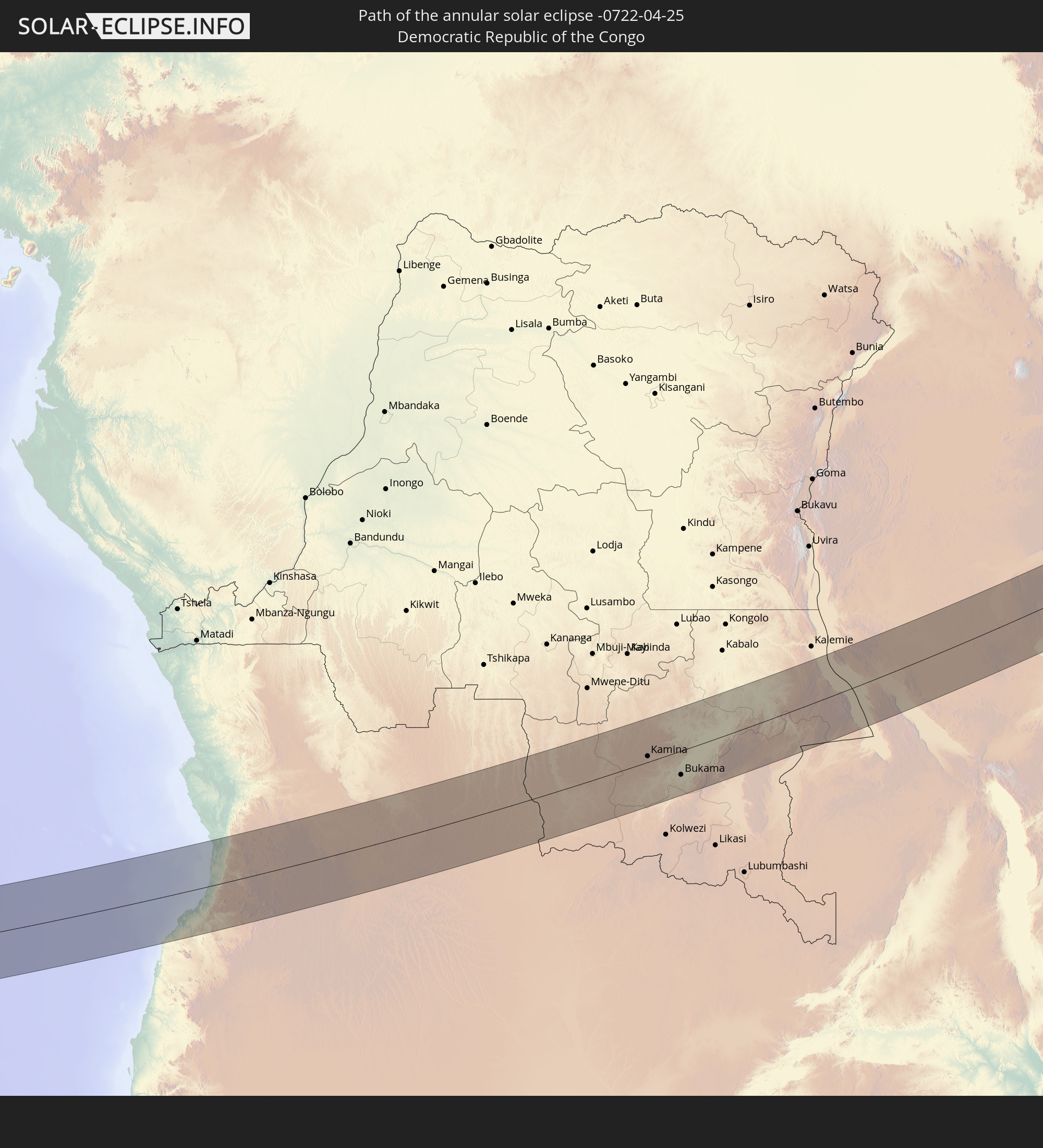 Democratic Republic of the Congo
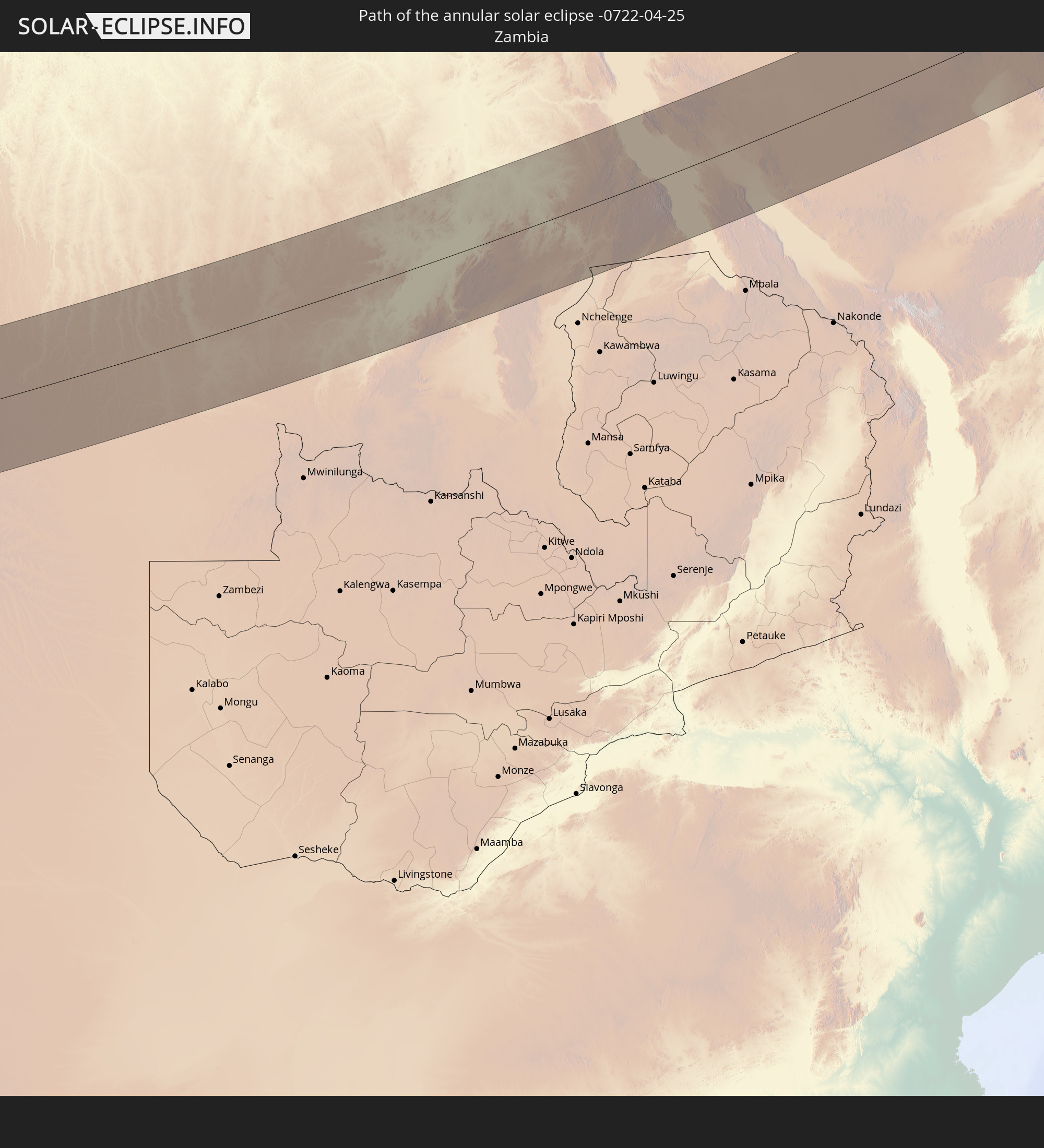 Zambia
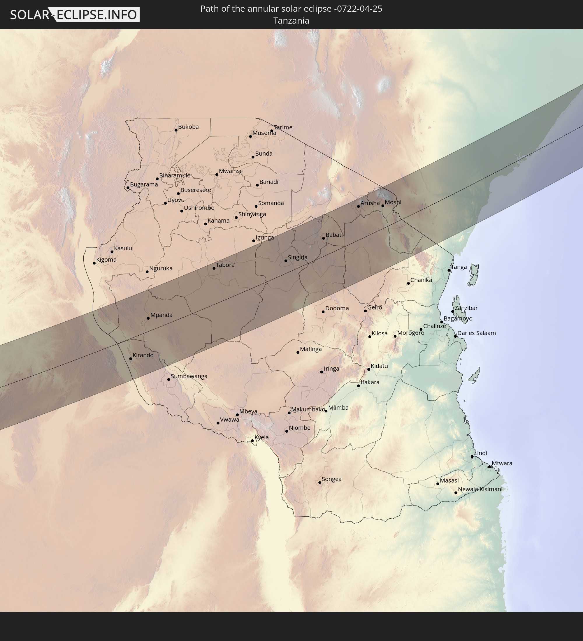 Tanzania
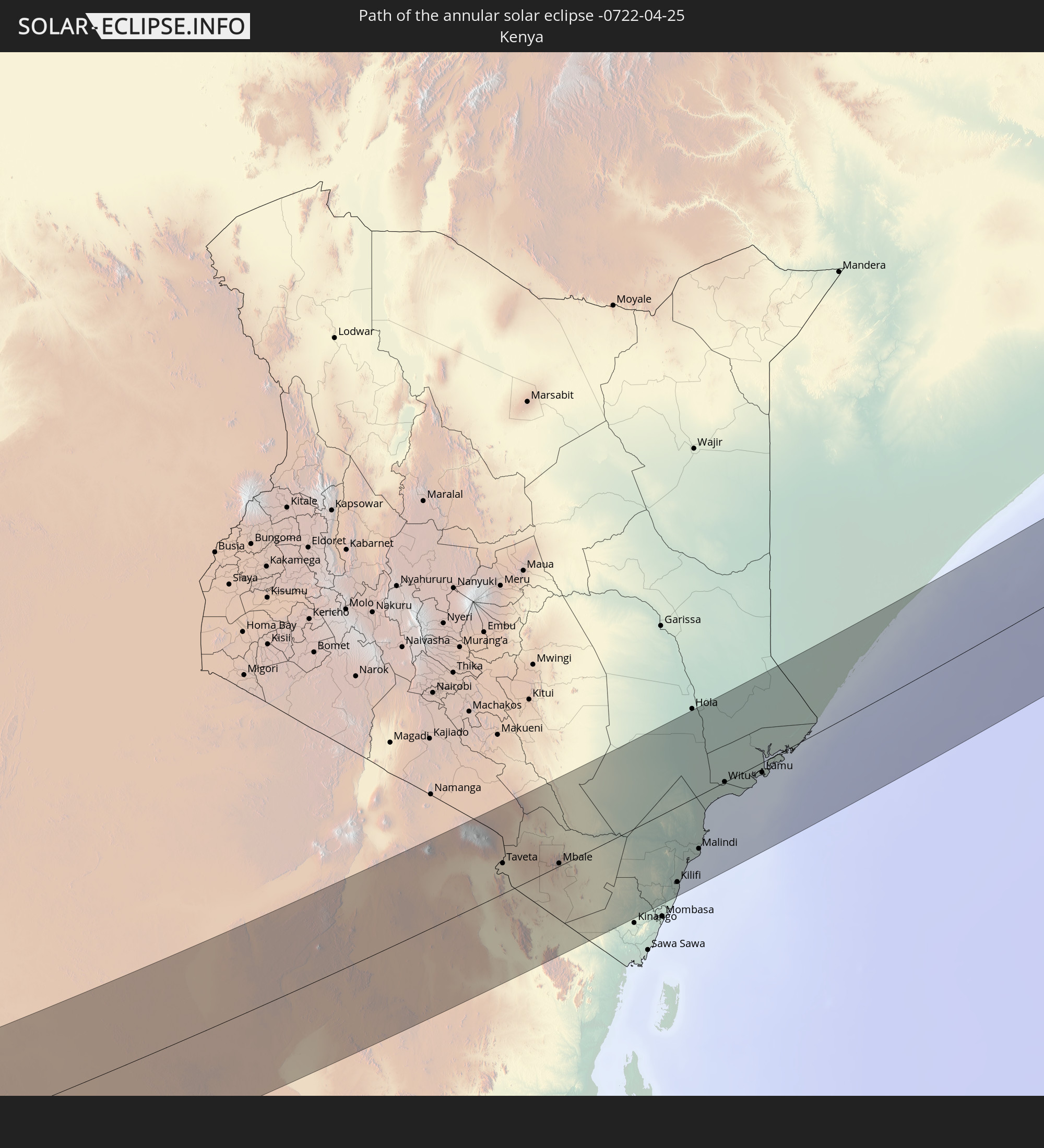 Kenya
Kenya
 Somalia
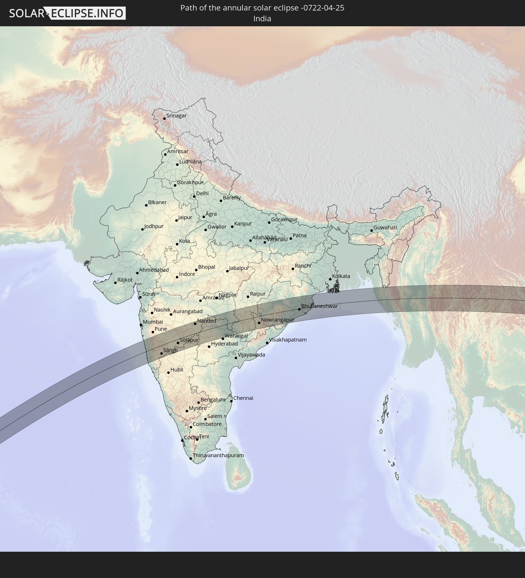 India
India
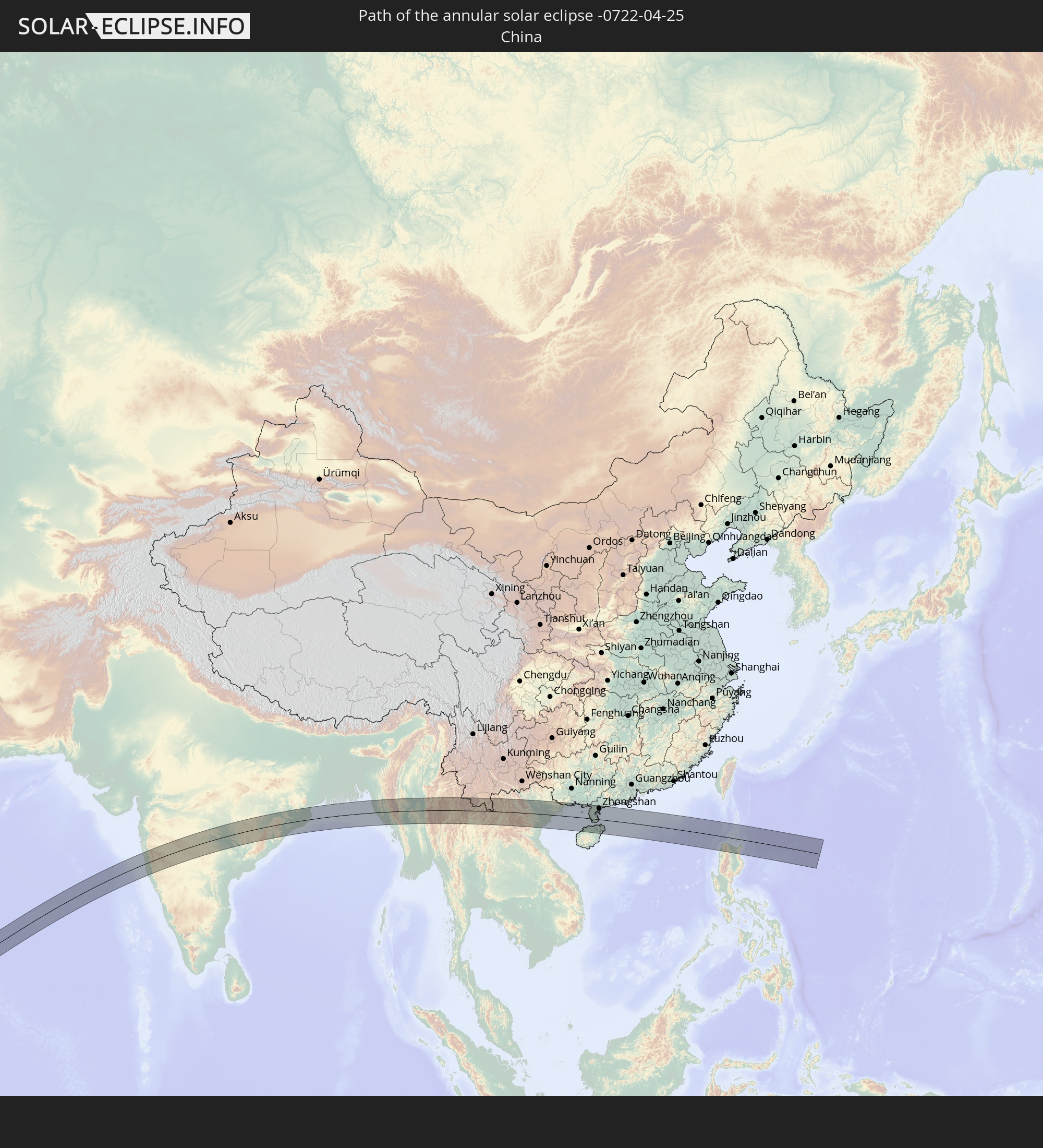 China
China
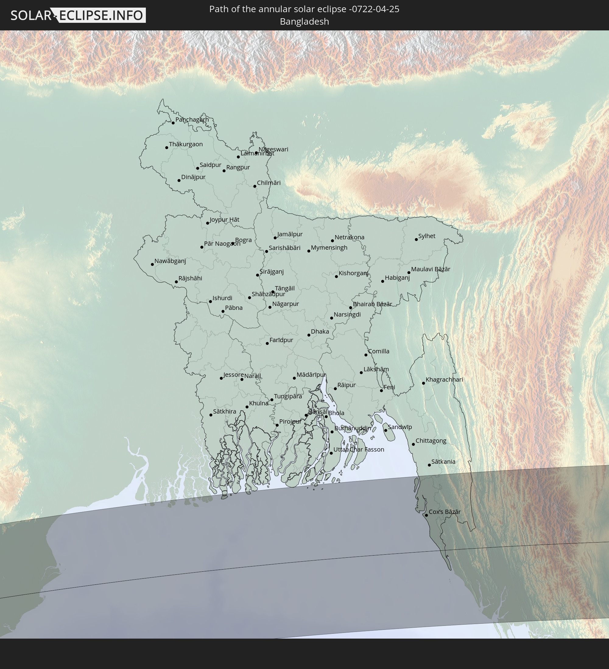 Bangladesh
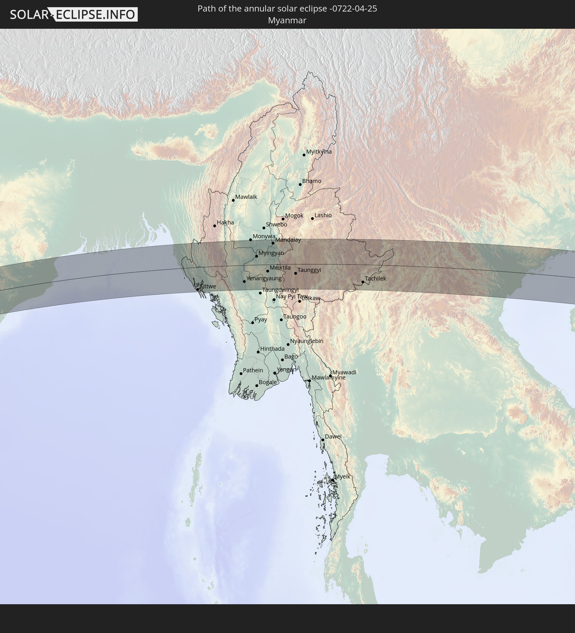 Myanmar
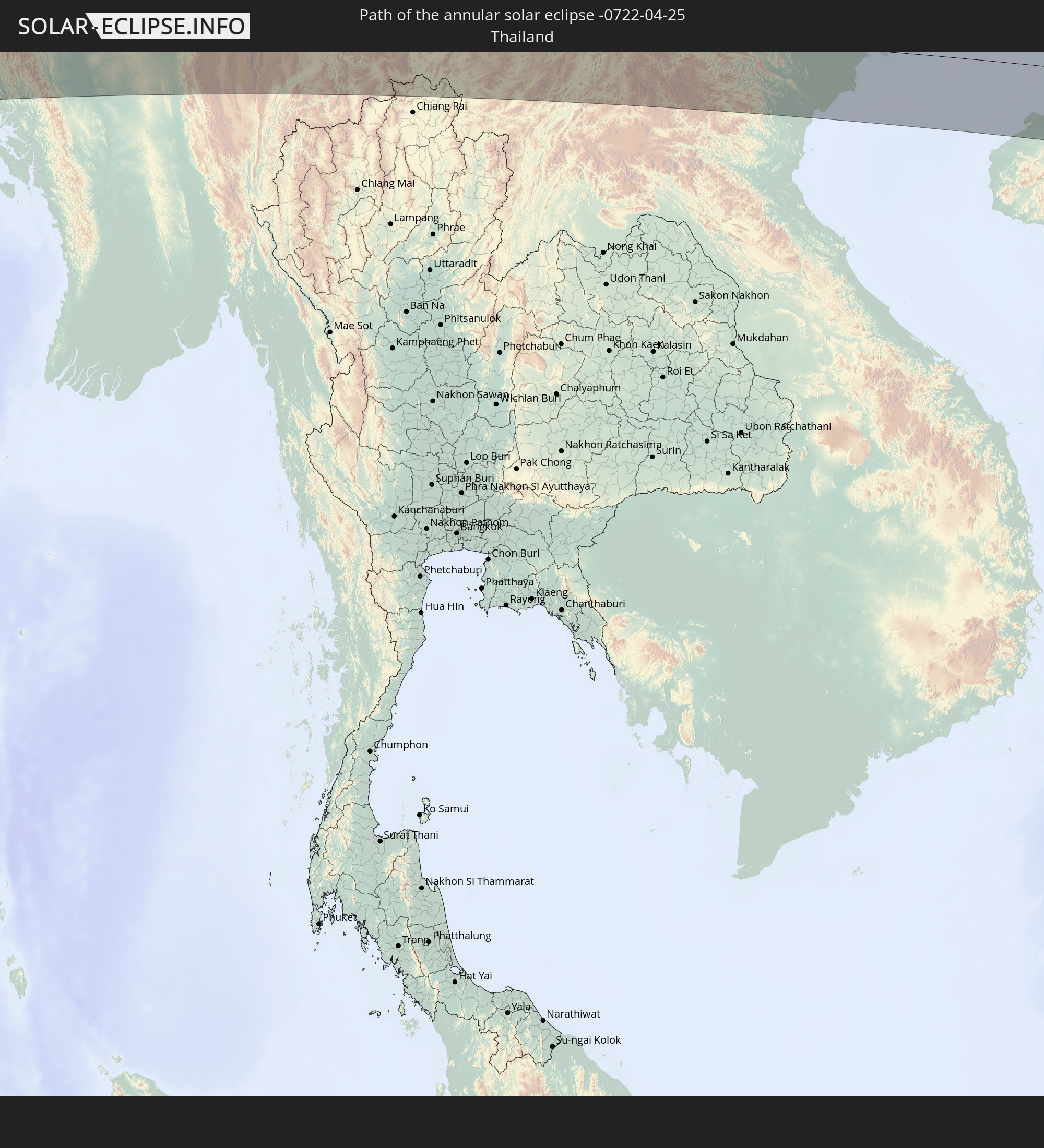 Thailand
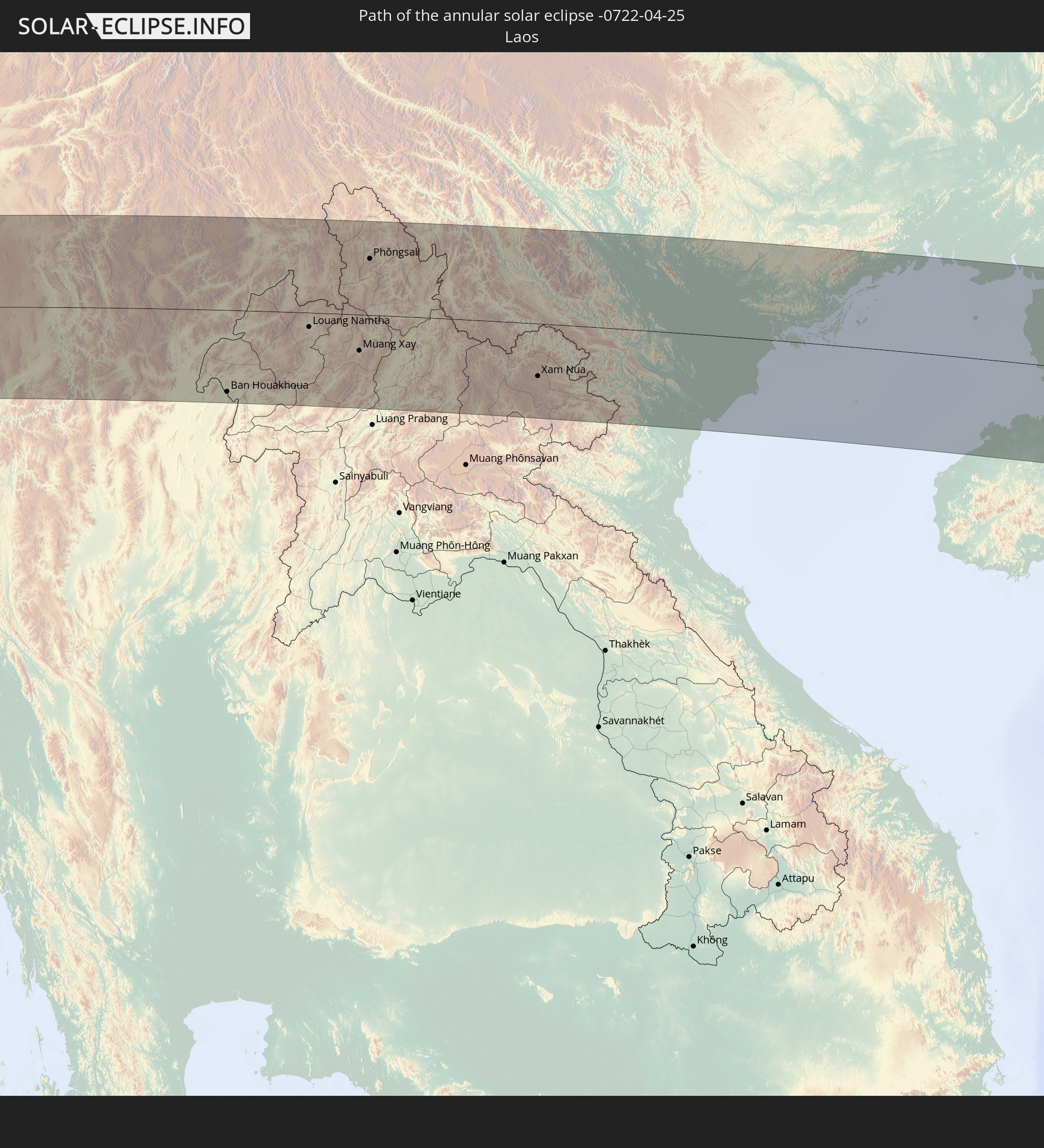 Laos
Laos
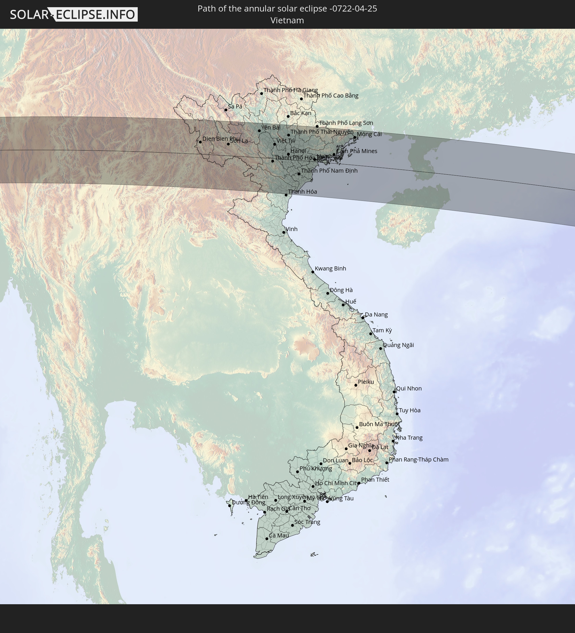 Vietnam
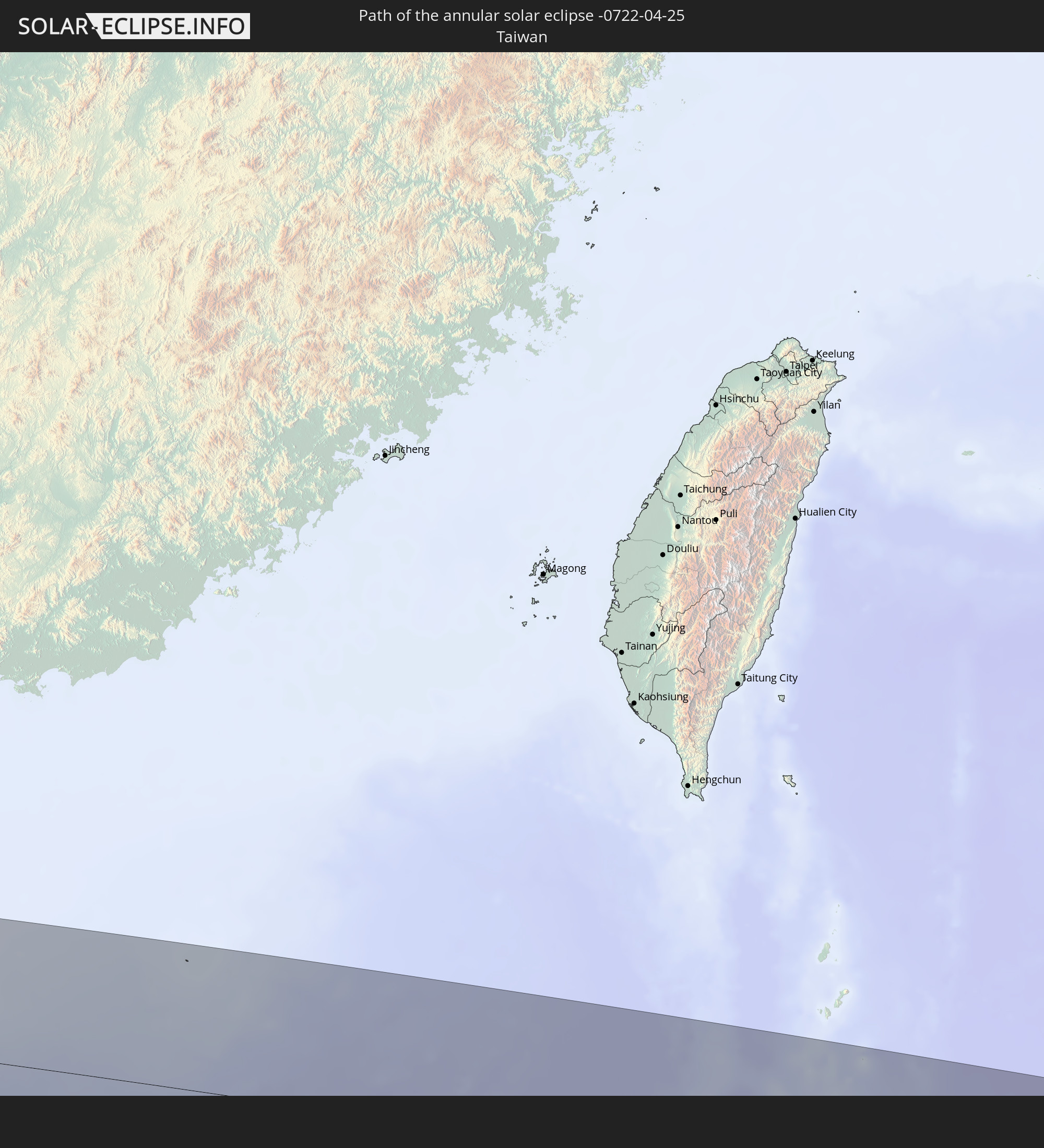 Taiwan
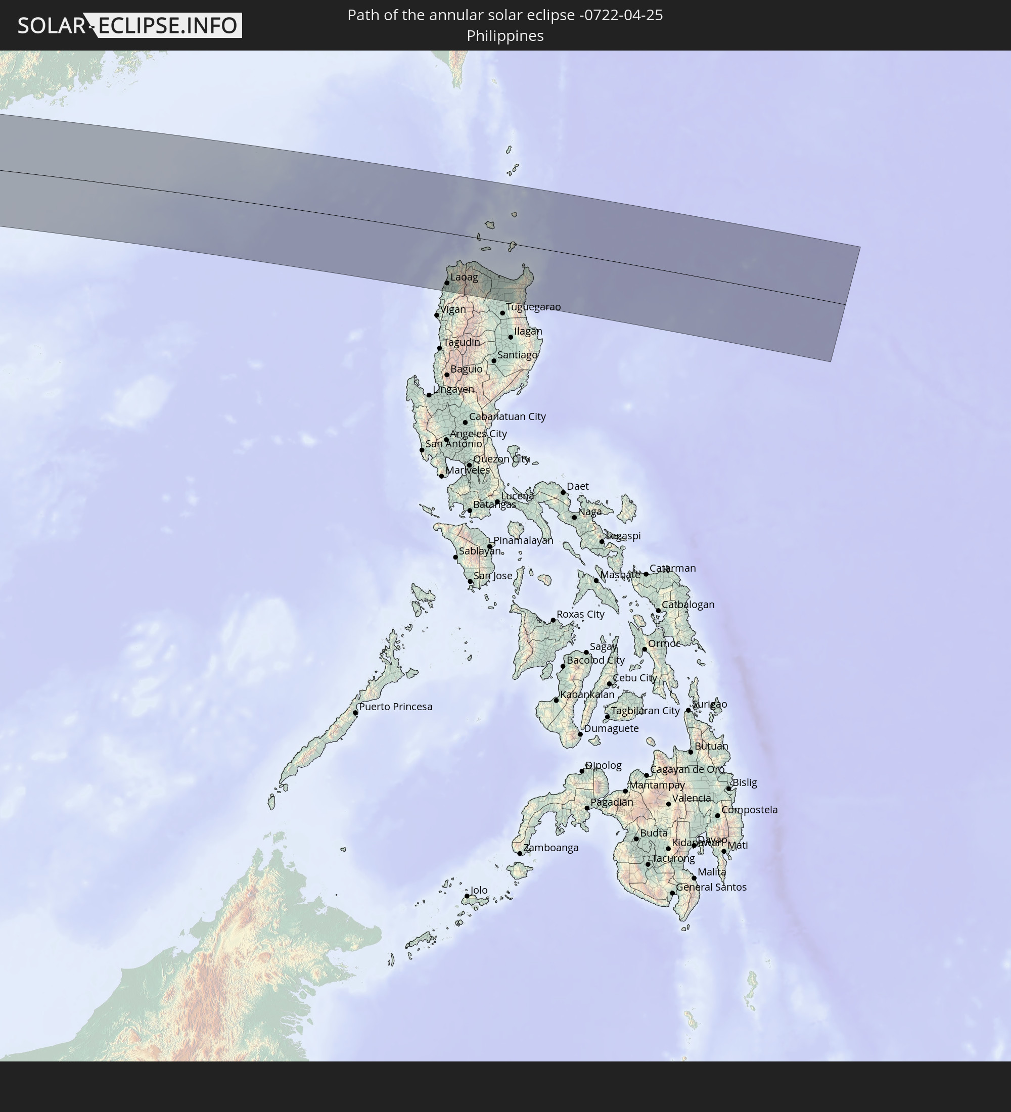 Philippines
In den folgenden Ländern ist die Sonnenfinsternis partiell zu sehen
 Russia
 Mauritania
 Mali
Mali
 Algeria
 Burkina Faso
 Ghana
Ghana
 Togo
Togo
 Niger
Niger
 Benin
Benin
 Nigeria
 Equatorial Guinea
 São Tomé and Príncipe
 Cameroon
 Gabon
Gabon
 Libya
Libya
 Republic of the Congo
 Angola
 Namibia
 Democratic Republic of the Congo
 Chad
Chad
 Central African Republic
 South Africa
 Botswana
 Sudan
Sudan
 Zambia
 Egypt
Egypt
 Zimbabwe
 Turkey
 Lesotho
 Rwanda
 Burundi
 Tanzania
 Uganda
 Mozambique
 Swaziland
 Cyprus
 Malawi
 Ethiopia
 Kenya
Kenya
 State of Palestine
 Israel
 Saudi Arabia
 Jordan
 Lebanon
 Syria
Syria
 Eritrea
 Iraq
Iraq
 Georgia
 French Southern and Antarctic Lands
 Somalia
 Djibouti
 Yemen
Yemen
 Madagascar
 Comoros
 Armenia
 Iran
Iran
 Azerbaijan
 Mayotte
 Seychelles
 Kazakhstan
 Kuwait
 Bahrain
 Qatar
Qatar
 United Arab Emirates
 Oman
Oman
 Turkmenistan
 Réunion
 Uzbekistan
 Mauritius
 Afghanistan
 Pakistan
 Tajikistan
 India
India
 Kyrgyzstan
 British Indian Ocean Territory
 Maldives
 China
China
 Sri Lanka
 Nepal
Nepal
 Mongolia
 Bangladesh
 Bhutan
 Myanmar
 Indonesia
 Cocos Islands
 Thailand
 Malaysia
 Laos
Laos
 Vietnam
 Cambodia
 Singapore
 Christmas Island
 Australia
 Macau
Macau
 Hong Kong
 Brunei
 Taiwan
 Philippines
 Japan
Japan
 East Timor
 North Korea
 South Korea
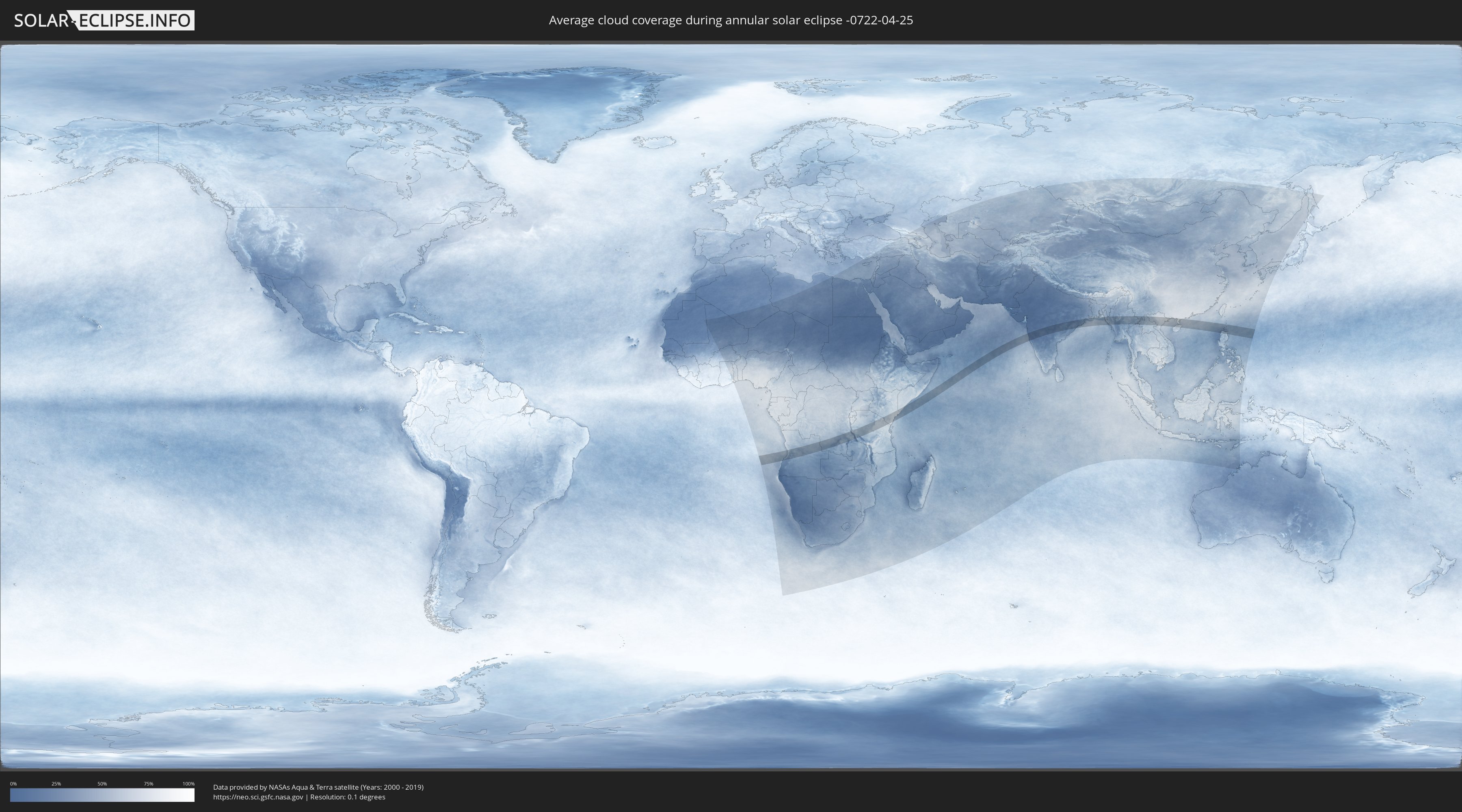
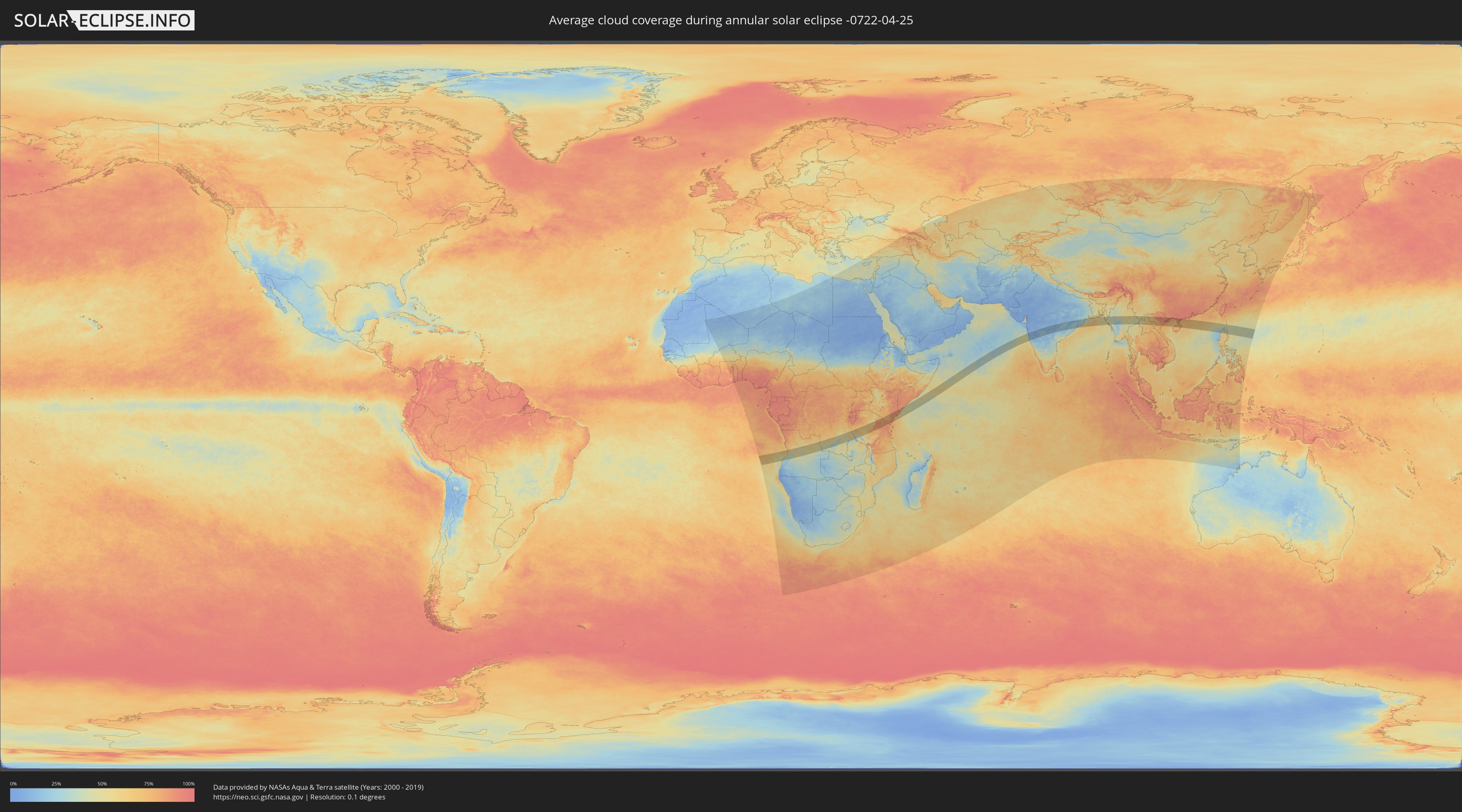
How will be the weather during the annular solar eclipse on 04/25/-0722?
Where is the best place to see the annular solar eclipse of 04/25/-0722?
The following maps show the average cloud coverage for the day of the annular solar eclipse.
With the help of these maps, it is possible to find the place along the eclipse path, which has the best
chance of a cloudless sky.
Nevertheless, you should consider local circumstances and inform about the weather of your chosen
observation site.
The data is provided by NASAs satellites
AQUA and TERRA.
The cloud maps are averaged over a period of 19 years (2000 - 2019).
Detailed country maps
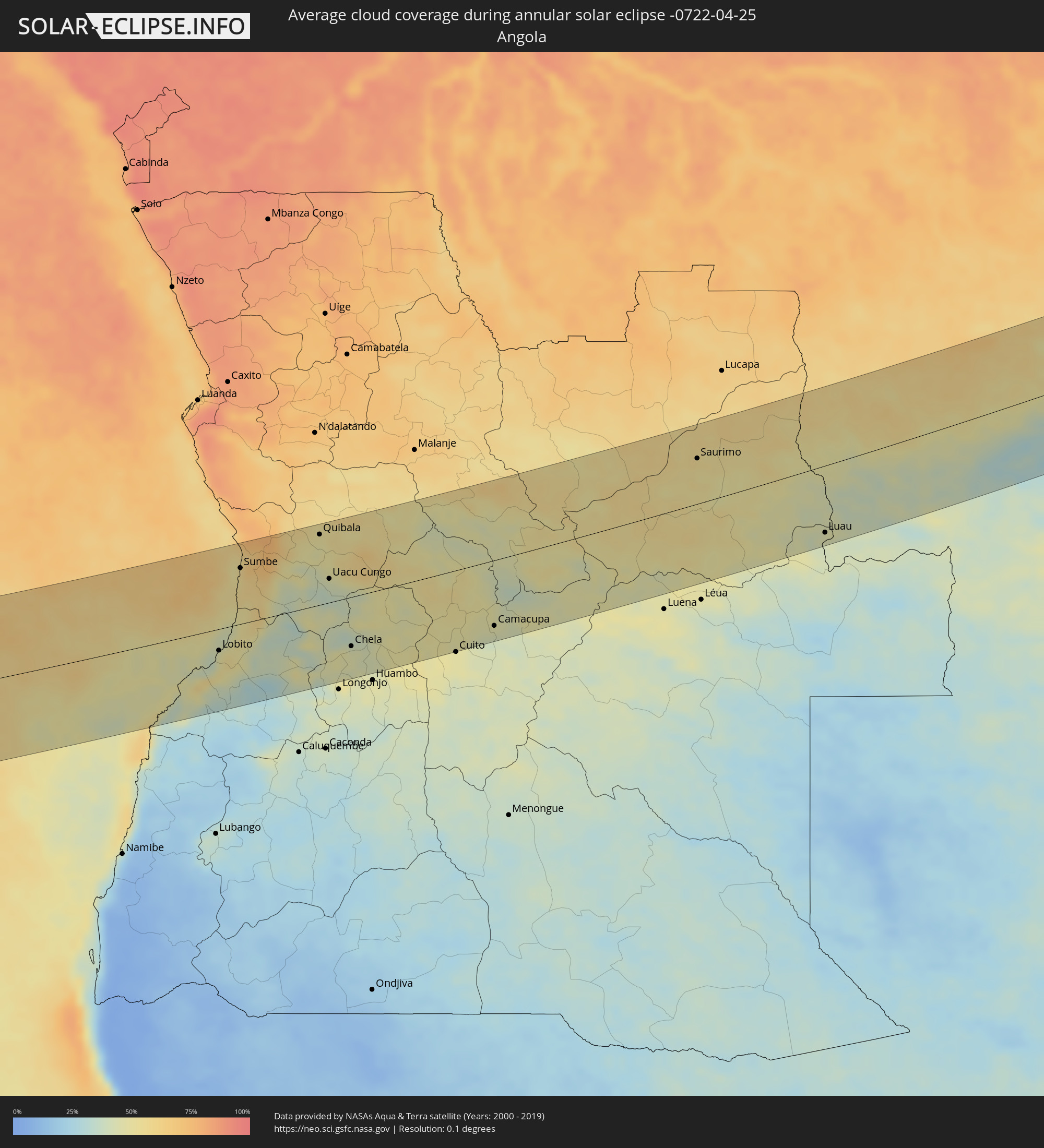 Angola
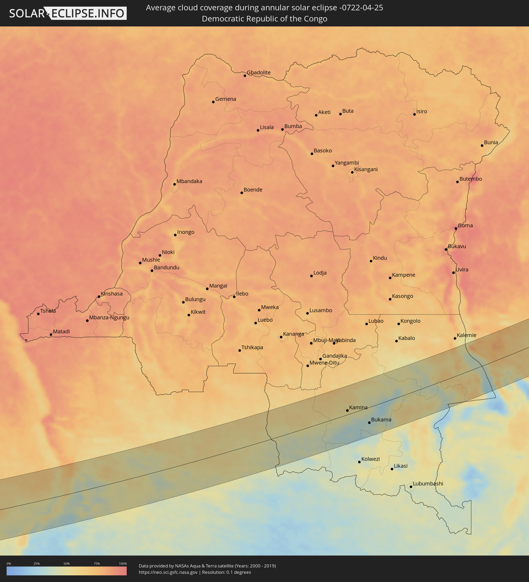 Democratic Republic of the Congo
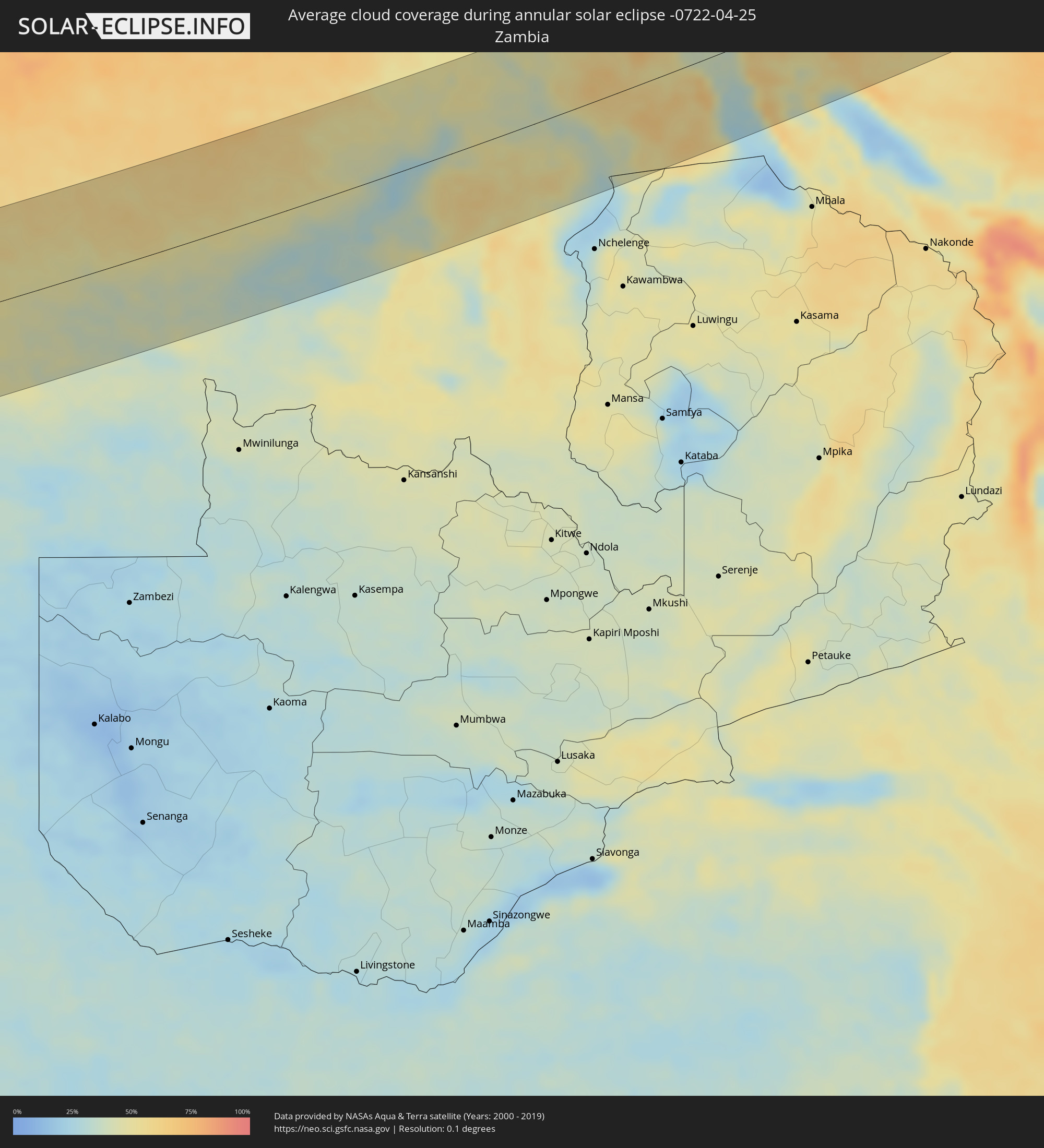 Zambia
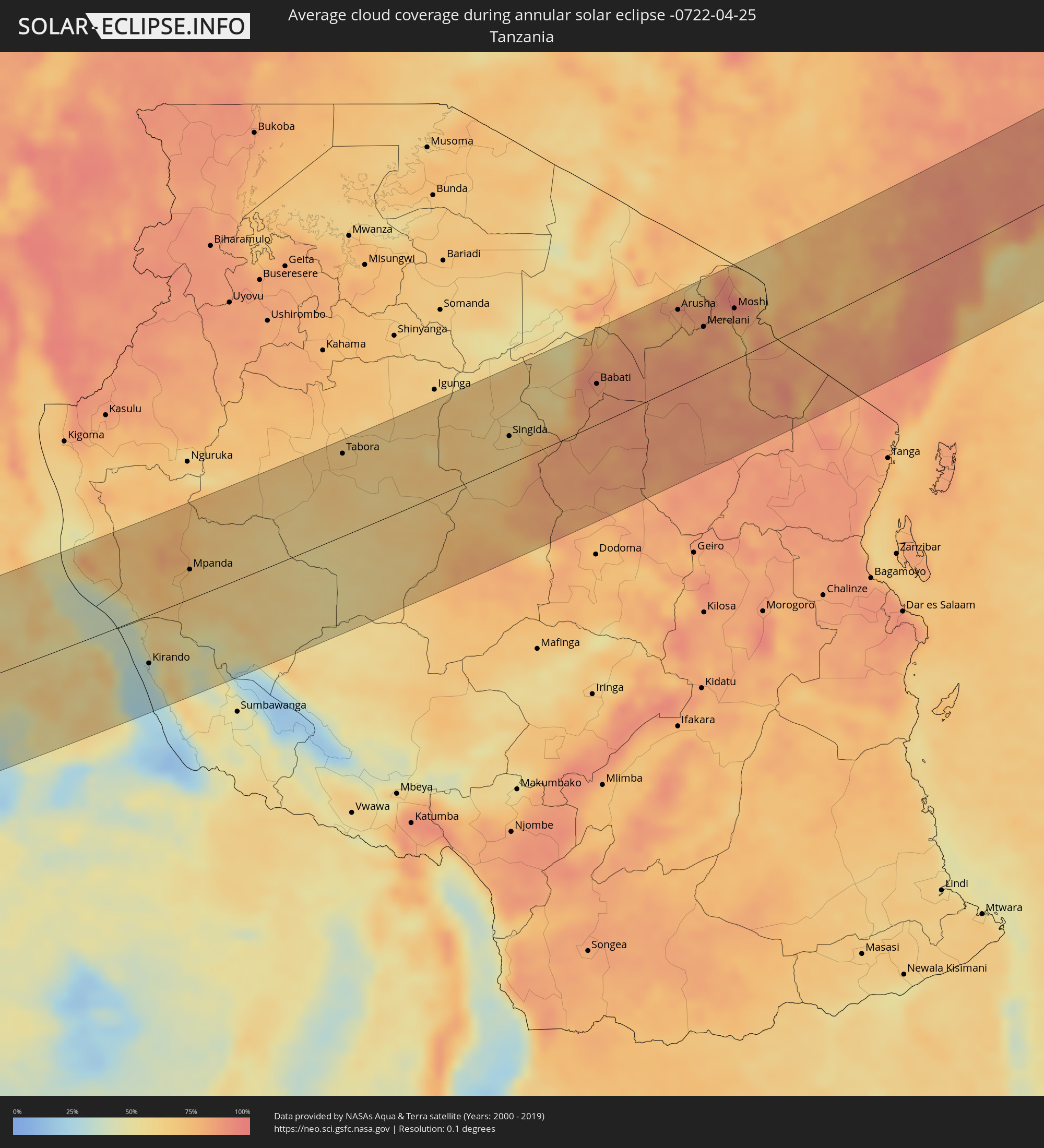 Tanzania
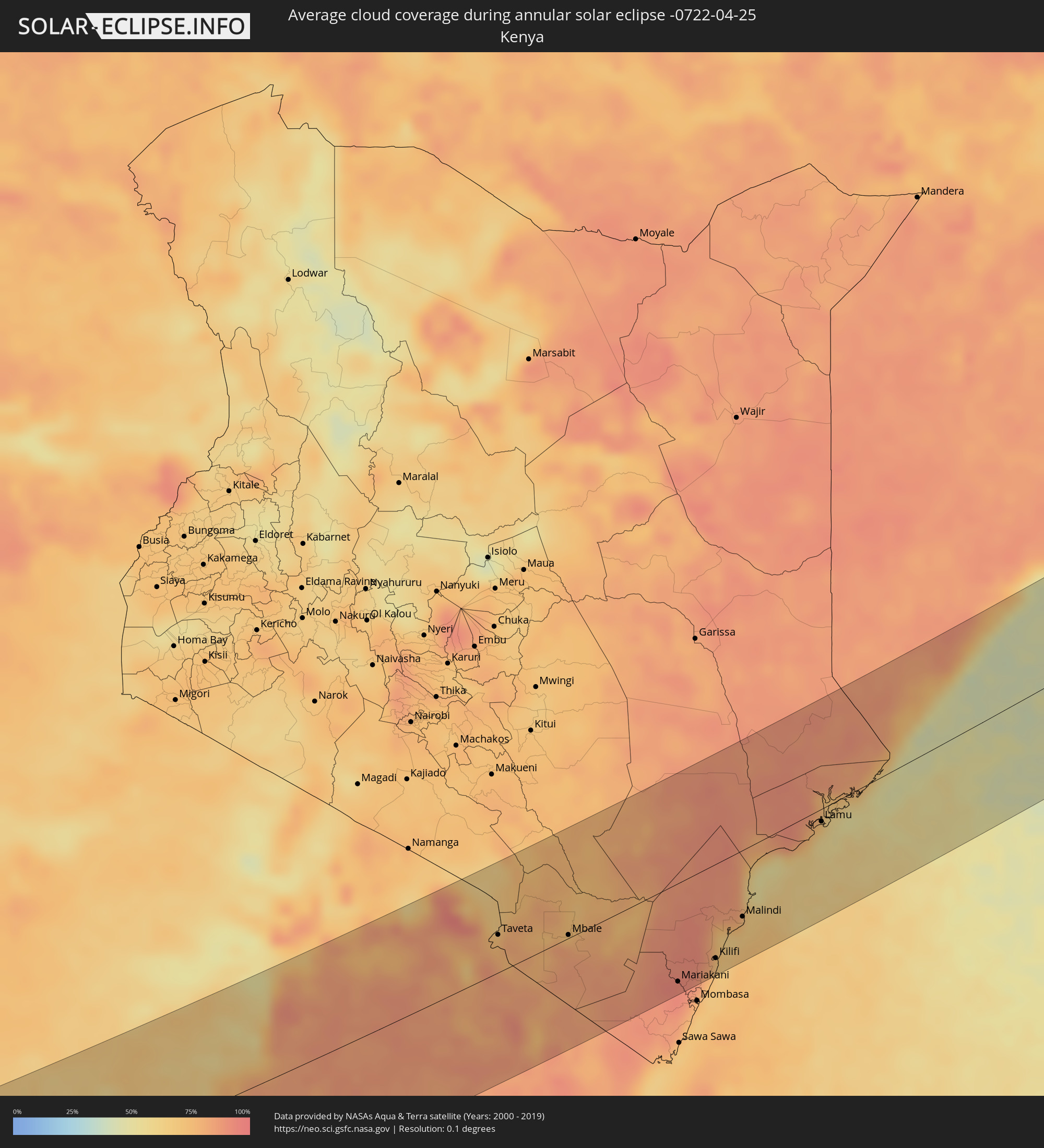 Kenya
Kenya
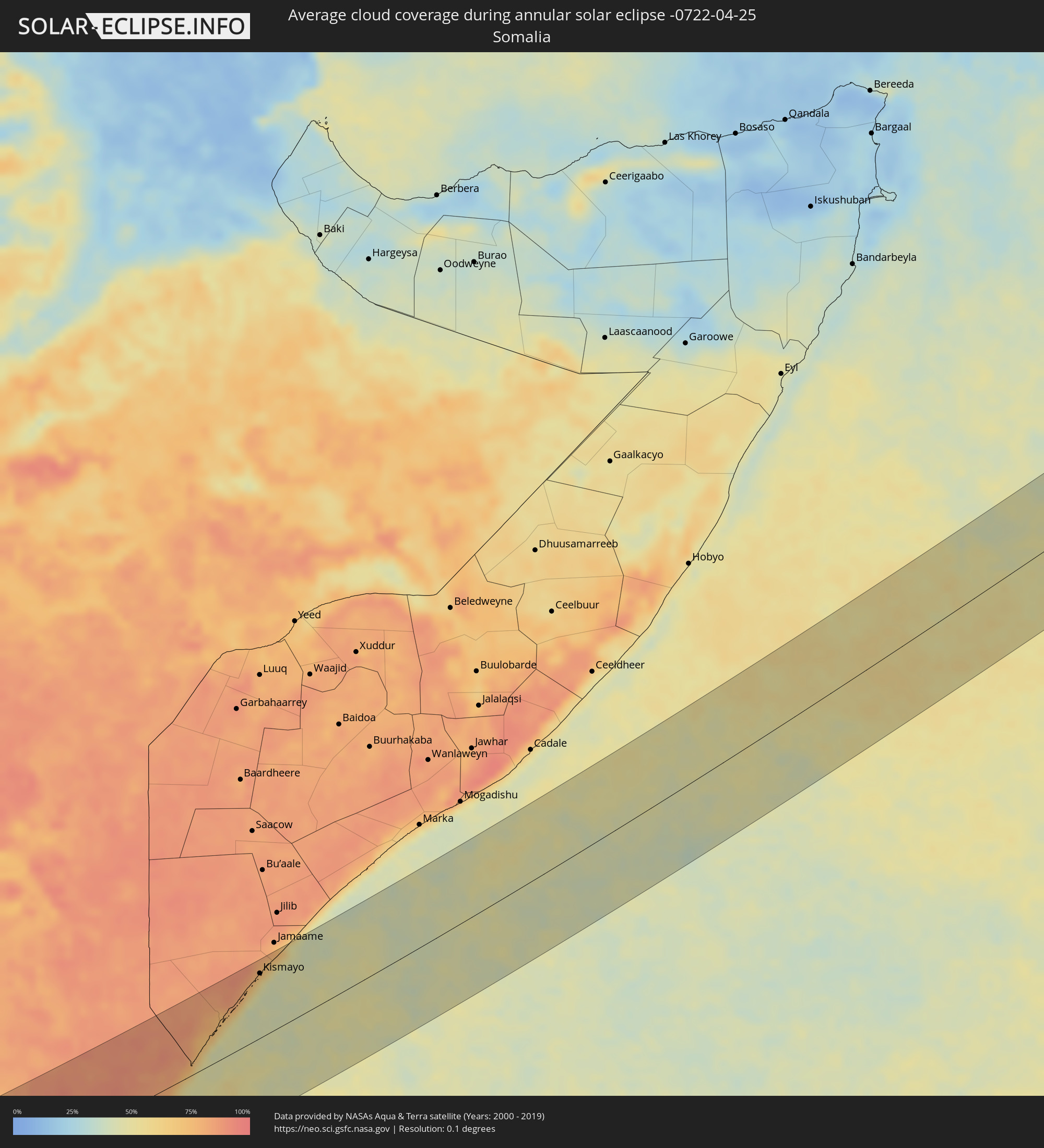 Somalia
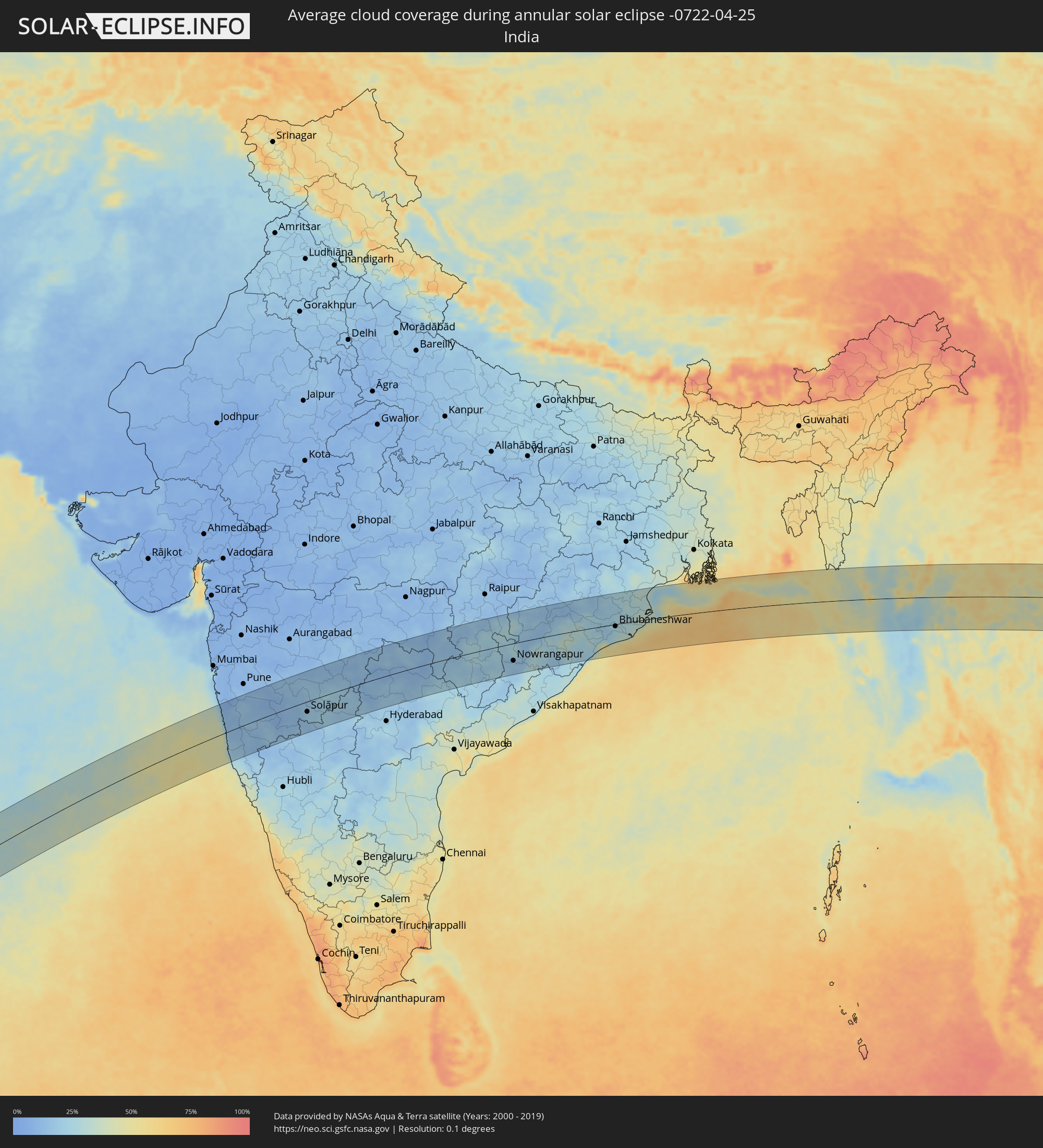 India
India
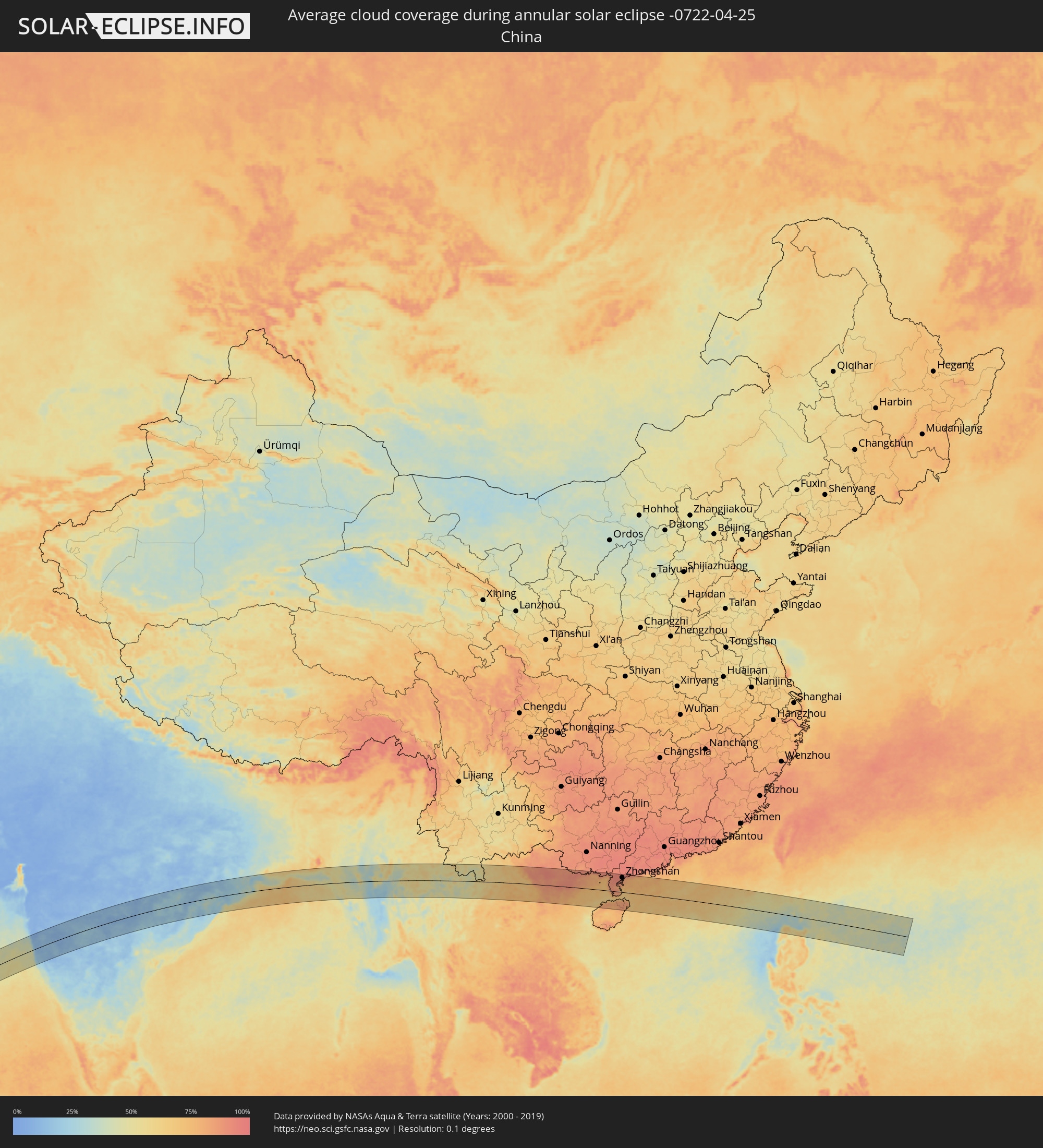 China
China
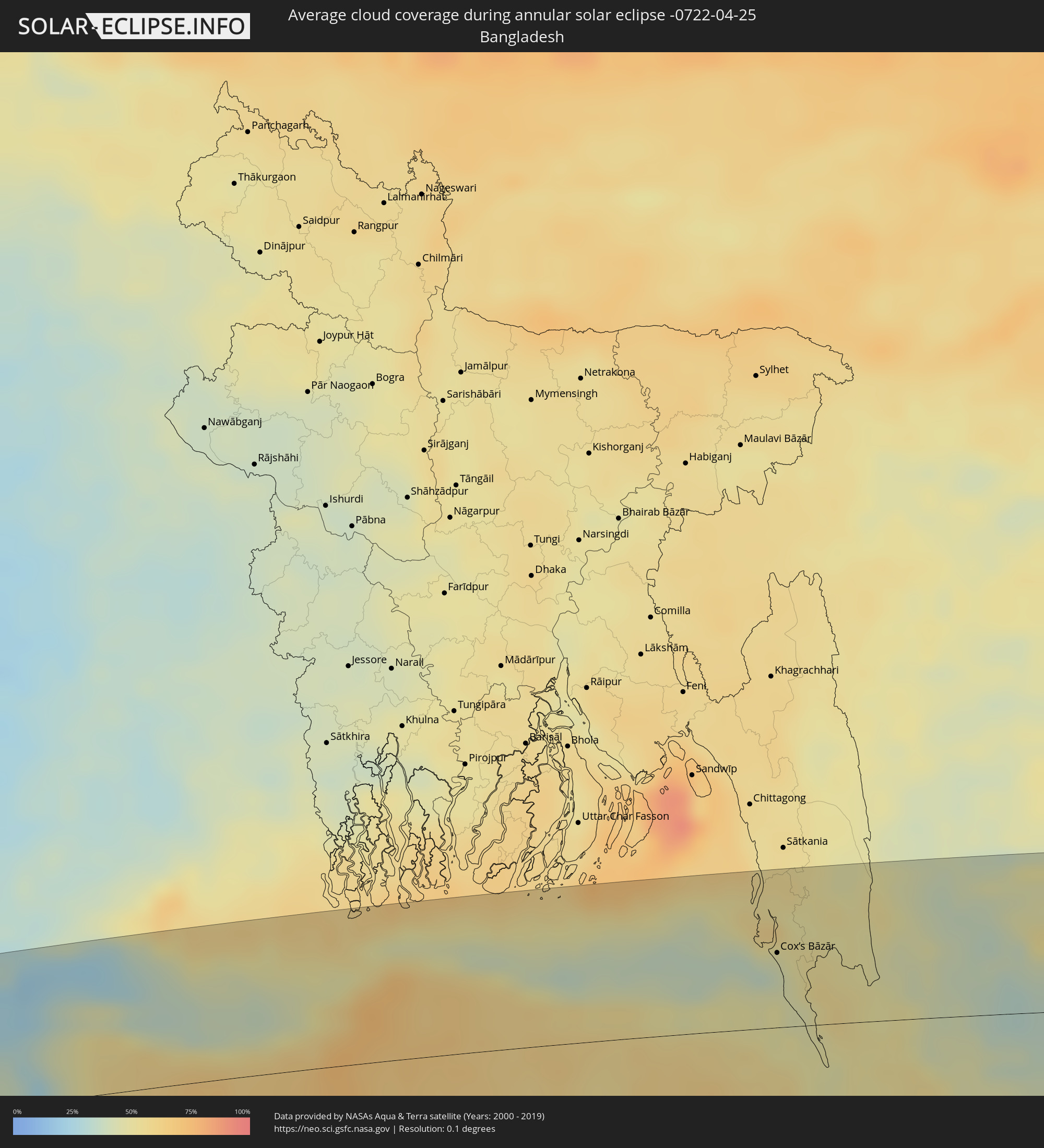 Bangladesh
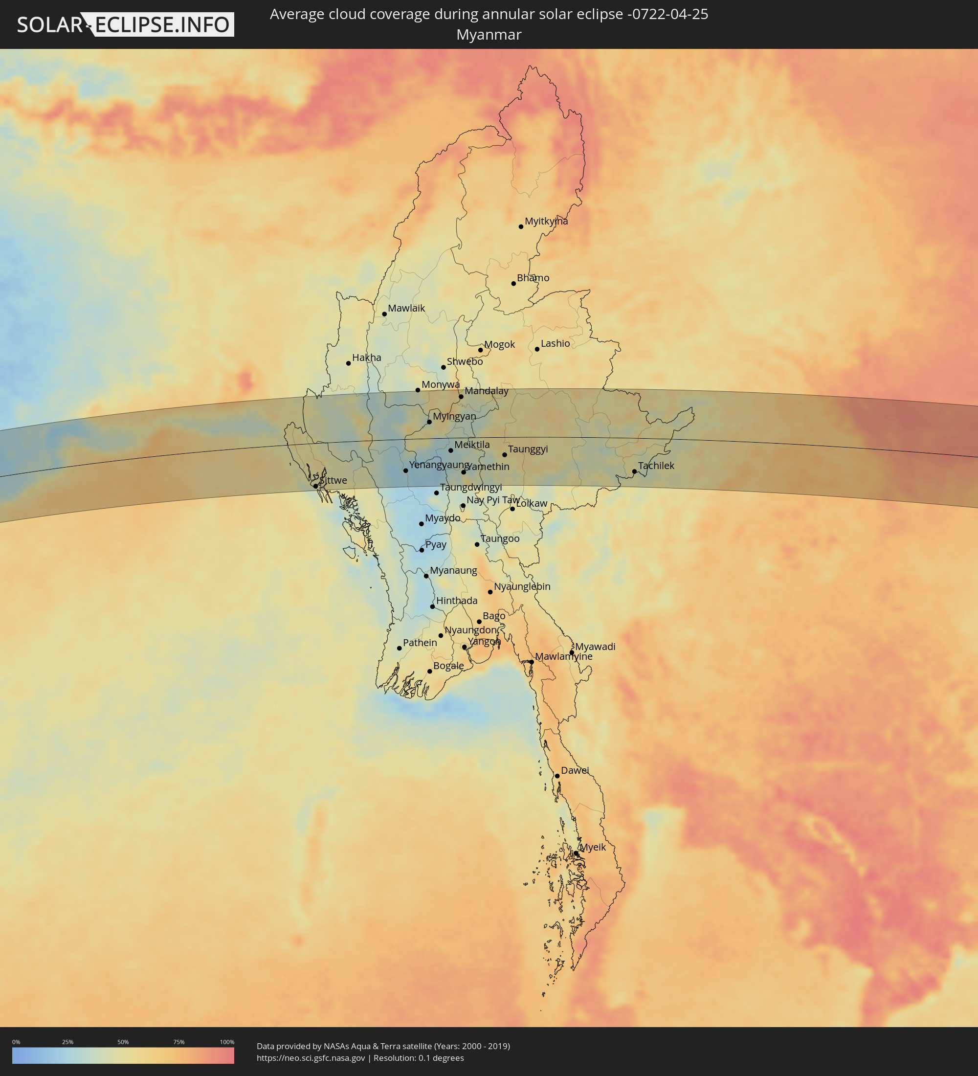 Myanmar
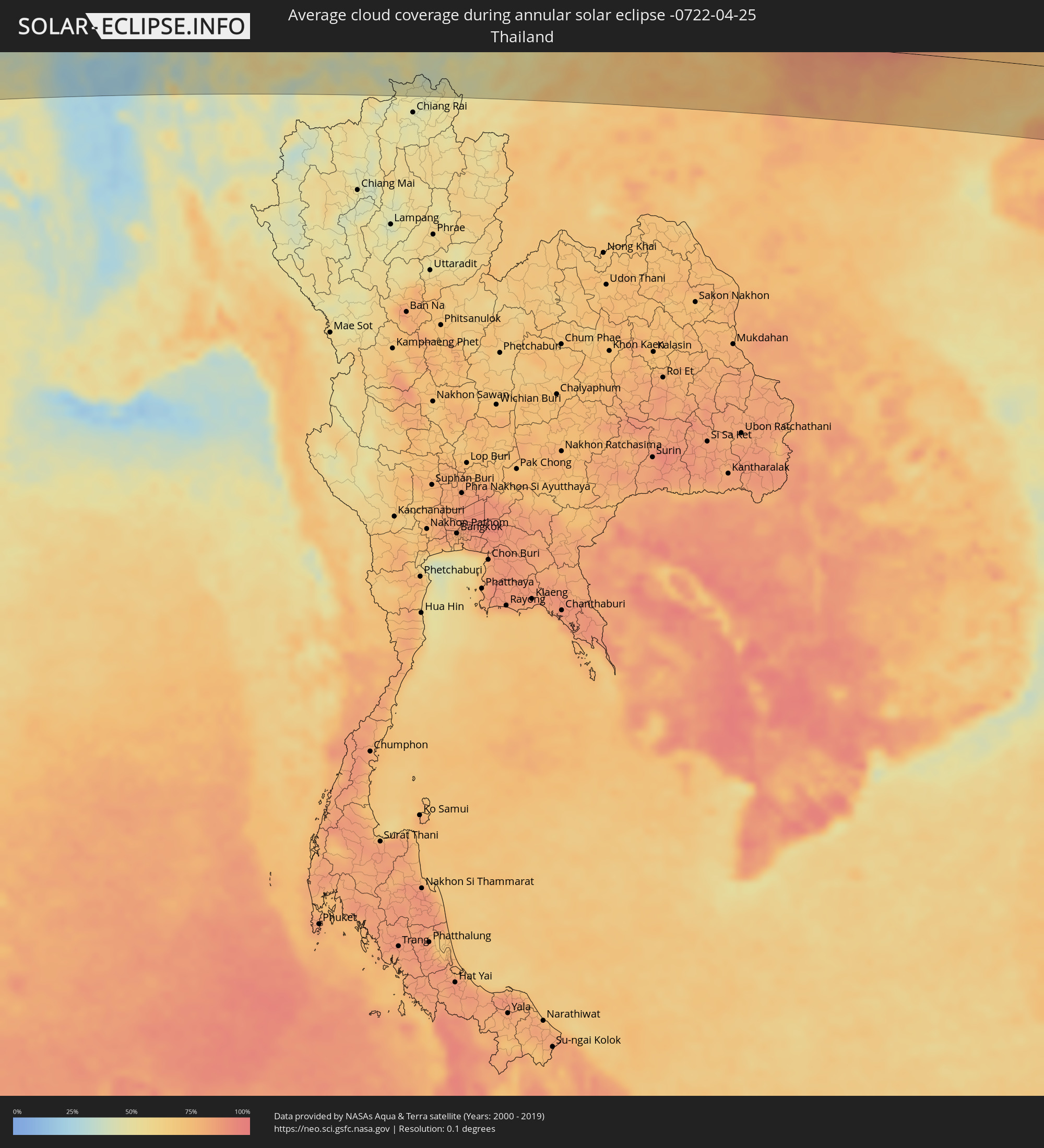 Thailand
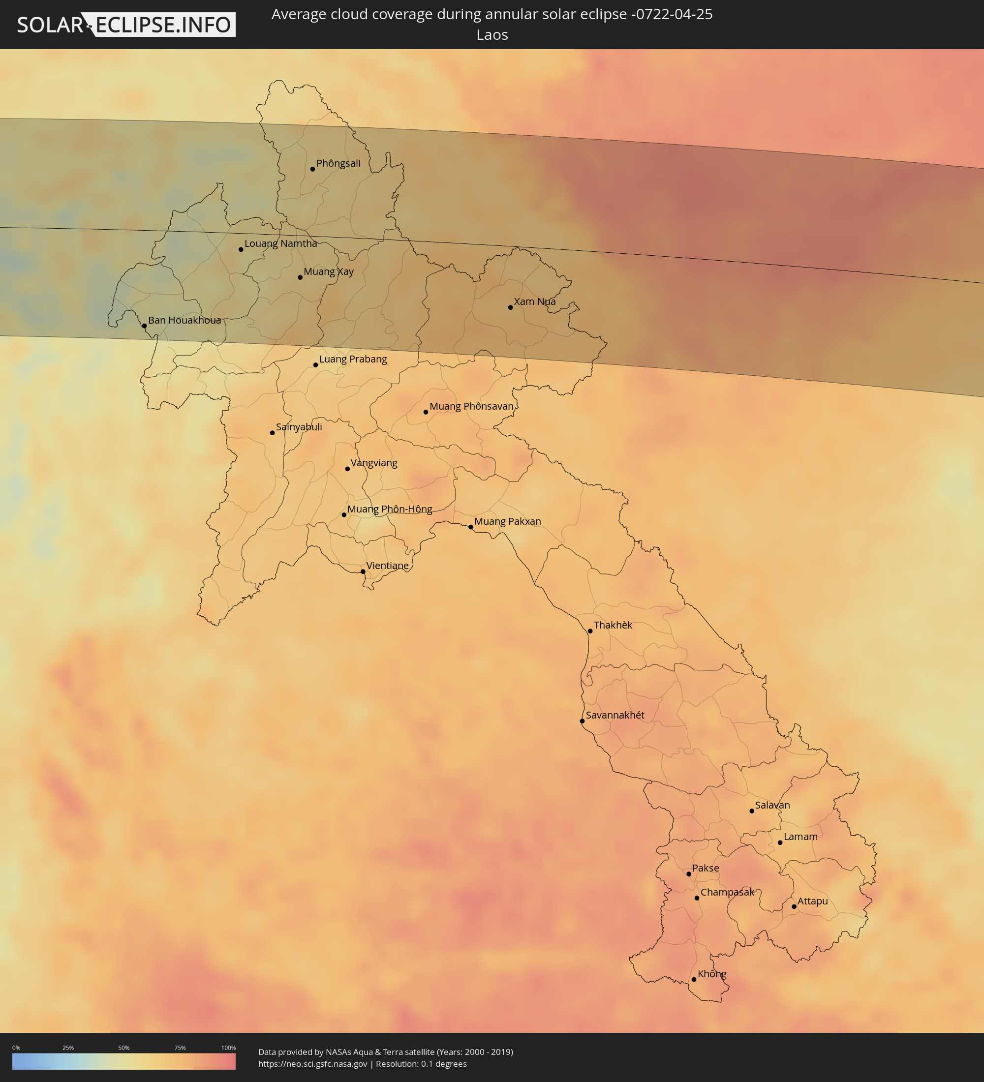 Laos
Laos
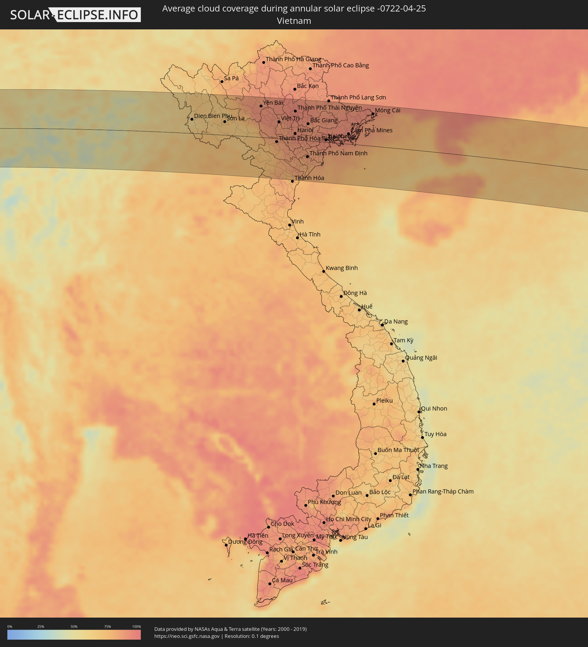 Vietnam
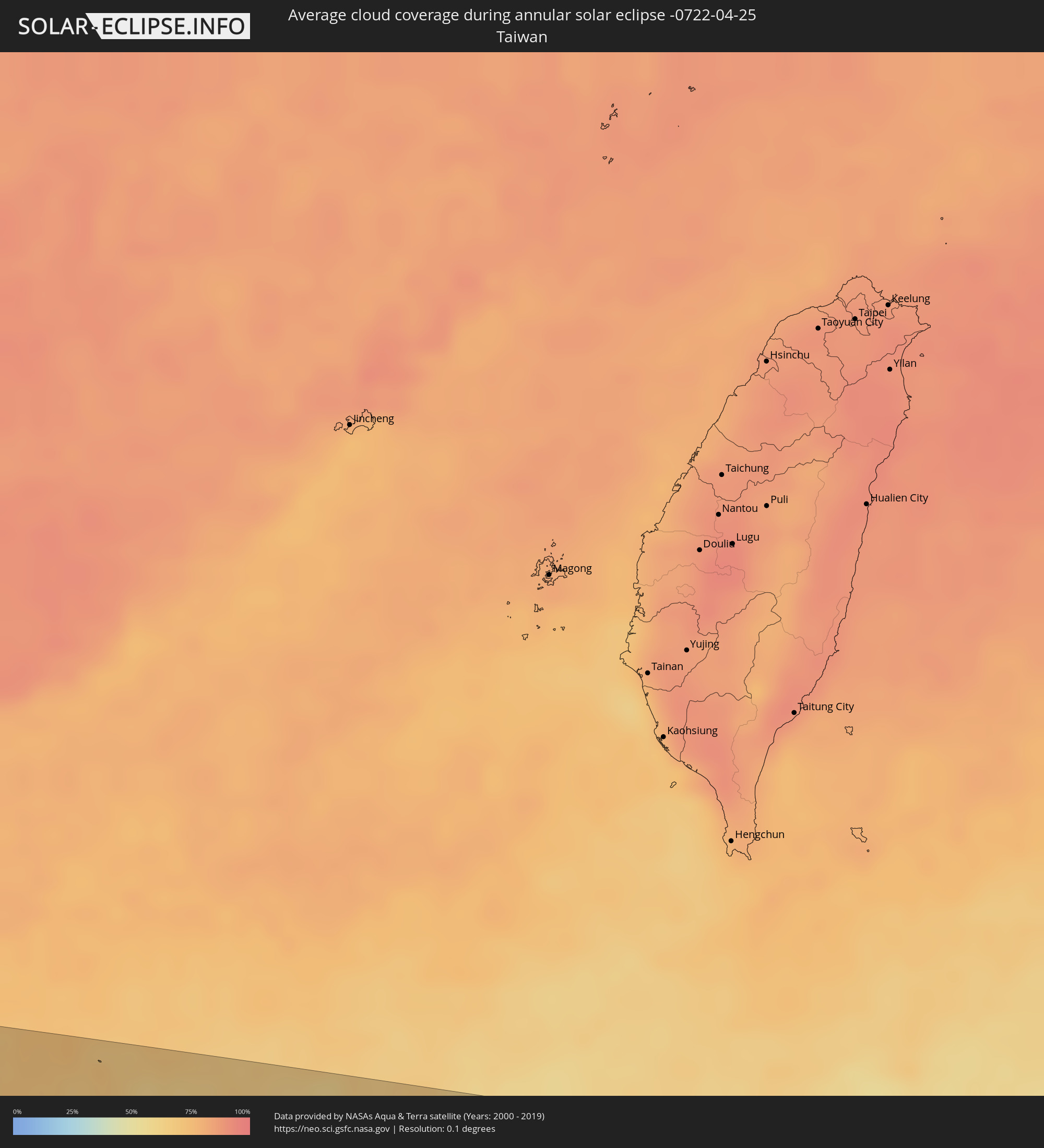 Taiwan
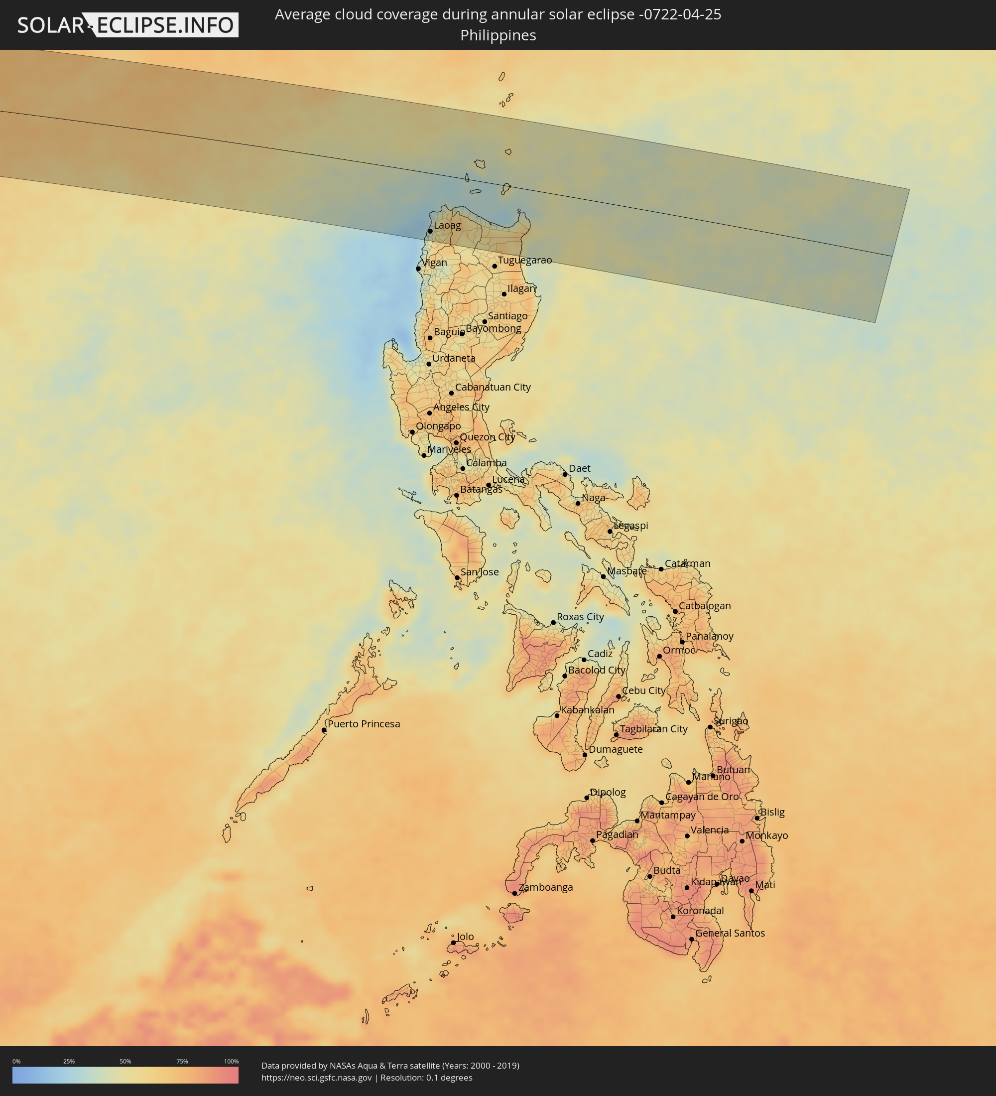 Philippines
Cities inside the path of the eclipse
The following table shows all locations with a population of more than 5,000 inside the eclipse path. Cities which have more than 100,000 inhabitants are marked bold. A click at the locations opens a detailed map.
| City | Type | Eclipse duration | Local time of max. eclipse | Distance to central line | Ø Cloud coverage |
|
Benguela, Benguela Province
|
annular | - | 05:52:48 UTC+00:13 | 53 km | 54% |
|
Lobito, Benguela Province
|
annular | - | 05:52:54 UTC+00:13 | 33 km | 47% |
|
Catumbela, Benguela Province
|
annular | - | 05:52:53 UTC+00:13 | 40 km | 47% |
|
Sumbe, Kwanza Sul
|
annular | - | 05:53:24 UTC+00:13 | 85 km | 56% |
|
Quibala, Kwanza Sul
|
annular | - | 05:53:51 UTC+00:13 | 107 km | 51% |
|
Uacu Cungo, Kwanza Sul
|
annular | - | 05:53:37 UTC+00:13 | 36 km | 40% |
|
Chela, Huambo
|
annular | - | 05:53:18 UTC+00:13 | 74 km | 44% |
|
Catabola, Bíe
|
annular | - | 05:53:52 UTC+00:13 | 108 km | 40% |
|
Chissamba, Bíe
|
annular | - | 05:53:52 UTC+00:13 | 111 km | 40% |
|
Camacupa, Bíe
|
annular | - | 05:53:59 UTC+00:13 | 99 km | 45% |
|
Saurimo, Lunda Sul
|
annular | - | 05:56:14 UTC+00:13 | 68 km | 52% |
|
Luau, Moxico
|
annular | - | 05:56:32 UTC+00:13 | 101 km | 44% |
|
Kamina, Katanga
|
annular | - | 07:56:07 UTC+02:10 | 16 km | 51% |
|
Bukama, Katanga
|
annular | - | 07:56:22 UTC+02:10 | 64 km | 35% |
|
Kirando, Rukwa
|
annular | - | 08:18:31 UTC+02:27 | 57 km | 38% |
|
Namanyere, Rukwa
|
annular | - | 08:18:52 UTC+02:27 | 86 km | 44% |
|
Mpanda, Katavi
|
annular | - | 08:19:55 UTC+02:27 | 35 km | 67% |
|
Sikonge, Tabora
|
annular | - | 08:22:21 UTC+02:27 | 36 km | 64% |
|
Tabora, Tabora
|
annular | - | 08:23:02 UTC+02:27 | 97 km | 68% |
|
Mgandu, Singida
|
annular | - | 08:23:34 UTC+02:27 | 56 km | 74% |
|
Shelui, Singida
|
annular | - | 08:25:17 UTC+02:27 | 103 km | 69% |
|
Kiomboi, Singida
|
annular | - | 08:25:36 UTC+02:27 | 105 km | 64% |
|
Sepuka, Singida
|
annular | - | 08:25:17 UTC+02:27 | 49 km | 63% |
|
Singida, Singida
|
annular | - | 08:25:28 UTC+02:27 | 32 km | 62% |
|
Mtinko, Singida
|
annular | - | 08:25:53 UTC+02:27 | 55 km | 60% |
|
Babati, Manyara
|
annular | - | 08:27:23 UTC+02:27 | 47 km | 84% |
|
Magugu, Manyara
|
annular | - | 08:27:37 UTC+02:27 | 67 km | 86% |
|
Arusha, Arusha
|
annular | - | 08:29:35 UTC+02:27 | 89 km | 79% |
|
Merelani, Arusha
|
annular | - | 08:29:46 UTC+02:27 | 55 km | 86% |
|
Moshi, Kilimanjaro
|
annular | - | 08:30:30 UTC+02:27 | 59 km | 78% |
|
Taveta
|
annular | - | 08:30:56 UTC+02:27 | 38 km | 75% |
|
Wundanyi, Taita Taveta
|
annular | - | 08:31:54 UTC+02:27 | 4 km | 82% |
|
Mbale, Vihiga
|
annular | - | 08:31:56 UTC+02:27 | 3 km | 82% |
|
Voi, Taita Taveta
|
annular | - | 08:32:12 UTC+02:27 | 5 km | 80% |
|
Mariakani, Kwale
|
annular | - | 08:32:59 UTC+02:27 | 97 km | 93% |
|
Kilifi, Kilifi
|
annular | - | 08:33:50 UTC+02:27 | 93 km | 82% |
|
Takaungu, Kilifi
|
annular | - | 08:33:47 UTC+02:27 | 98 km | 68% |
|
Malindi, Kilifi
|
annular | - | 08:34:46 UTC+02:27 | 65 km | 74% |
|
Witu, Lamu
|
annular | - | 08:36:22 UTC+02:27 | 0 km | 81% |
|
Lamu, Lamu
|
annular | - | 08:37:16 UTC+02:27 | 12 km | 62% |
|
Kismayo, Lower Juba
|
annular | - | 08:42:48 UTC+02:27 | 88 km | 58% |
|
Kolhāpur, Maharashtra
|
annular | - | 13:37:51 UTC+05:21 | 72 km | 12% |
|
Ichalkaranji, Maharashtra
|
annular | - | 13:38:34 UTC+05:21 | 82 km | 11% |
|
Sāngli, Maharashtra
|
annular | - | 13:39:06 UTC+05:21 | 69 km | 17% |
|
Solāpur, Maharashtra
|
annular | - | 13:44:18 UTC+05:21 | 33 km | 18% |
|
Latur, Maharashtra
|
annular | - | 13:47:06 UTC+05:21 | 21 km | 20% |
|
Nanded, Maharashtra
|
annular | - | 13:50:06 UTC+05:21 | 77 km | 11% |
|
Bīdar, Karnataka
|
annular | - | 13:49:28 UTC+05:21 | 62 km | 18% |
|
Nizāmābād, Telangana
|
annular | - | 13:51:54 UTC+05:21 | 1 km | 13% |
|
Ādilābād, Telangana
|
annular | - | 13:54:05 UTC+05:21 | 94 km | 13% |
|
Karīmnagar, Telangana
|
annular | - | 13:54:40 UTC+05:21 | 55 km | 15% |
|
Rāmgundam, Telangana
|
annular | - | 13:55:55 UTC+05:21 | 25 km | 13% |
|
Nowrangapur, Odisha
|
annular | - | 14:04:44 UTC+05:21 | 57 km | 17% |
|
Brahmapur, Odisha
|
annular | - | 14:10:32 UTC+05:21 | 94 km | 27% |
|
Puri, Odisha
|
annular | - | 14:13:17 UTC+05:21 | 59 km | 50% |
|
Bhubaneshwar, Odisha
|
annular | - | 14:13:31 UTC+05:21 | 7 km | 24% |
|
Cuttack, Odisha
|
annular | - | 14:13:42 UTC+05:21 | 13 km | 27% |
|
Cox’s Bāzār, Chittagong
|
annular | - | 14:59:03 UTC+05:53 | 50 km | 40% |
|
Teknāf, Chittagong
|
annular | - | 14:59:32 UTC+05:53 | 16 km | 48% |
|
Sittwe, Rakhine
|
annular | - | 15:32:02 UTC+06:24 | 99 km | 40% |
|
Chauk, Magway
|
annular | - | 15:35:30 UTC+06:24 | 24 km | 34% |
|
Yenangyaung, Magway
|
annular | - | 15:35:35 UTC+06:24 | 73 km | 26% |
|
Minbu, Magway
|
annular | - | 15:35:35 UTC+06:24 | 105 km | 25% |
|
Magway, Magway
|
annular | - | 15:35:41 UTC+06:24 | 108 km | 23% |
|
Pakokku, Magway
|
annular | - | 15:35:56 UTC+06:24 | 23 km | 50% |
|
Myingyan, Mandalay
|
annular | - | 15:36:26 UTC+06:24 | 36 km | 43% |
|
Meiktila, Mandalay
|
annular | - | 15:37:13 UTC+06:24 | 30 km | 34% |
|
Sagaing, Sagain
|
annular | - | 15:37:22 UTC+06:24 | 81 km | 50% |
|
Mandalay, Mandalay
|
annular | - | 15:37:31 UTC+06:24 | 92 km | 46% |
|
Kyaukse, Mandalay
|
annular | - | 15:37:38 UTC+06:24 | 51 km | 36% |
|
Yamethin, Mandalay
|
annular | - | 15:37:41 UTC+06:24 | 80 km | 48% |
|
Pyin Oo Lwin, Mandalay
|
annular | - | 15:38:06 UTC+06:24 | 98 km | 43% |
|
Taunggyi, Shan
|
annular | - | 15:39:05 UTC+06:24 | 41 km | 49% |
|
Mae Chan, Chiang Rai
|
annular | - | 16:00:31 UTC+06:42 | 111 km | 46% |
|
Mae Sai, Chiang Rai
|
annular | - | 16:00:31 UTC+06:42 | 79 km | 47% |
|
Tachilek, Shan
|
annular | - | 16:00:32 UTC+06:42 | 77 km | 47% |
|
Chiang Saen, Chiang Rai
|
annular | - | 16:00:50 UTC+06:42 | 96 km | 47% |
|
Chiang Khong, Chiang Rai
|
annular | - | 16:01:15 UTC+06:42 | 97 km | 51% |
|
Ban Houayxay, Bokeo Province
|
annular | - | 16:01:16 UTC+06:42 | 95 km | 51% |
|
Ban Houakhoua, Bokeo Province
|
annular | - | 16:01:19 UTC+06:42 | 98 km | 48% |
|
Jinghong, Yunnan
|
annular | - | 17:19:20 UTC+08:00 | 97 km | 54% |
|
Louang Namtha, Loungnamtha
|
annular | - | 16:02:26 UTC+06:42 | 17 km | 53% |
|
Muang Xay, Oudômxai
|
annular | - | 16:03:12 UTC+06:42 | 43 km | 62% |
|
Phôngsali, Phôngsali
|
annular | - | 16:03:09 UTC+06:42 | 67 km | 60% |
|
Xam Nua, Houaphan
|
annular | - | 16:05:38 UTC+06:42 | 63 km | 71% |
|
Yên Bái, Yên Bái
|
annular | - | 16:30:50 UTC+07:06 | 88 km | 89% |
|
Thành Phố Hòa Bình, Hòa Bình
|
annular | - | 16:31:29 UTC+07:06 | 10 km | 79% |
|
Việt Trì, Phú Thọ
|
annular | - | 16:31:26 UTC+07:06 | 47 km | 85% |
|
Hà Đông, Ha Nội
|
annular | - | 16:31:53 UTC+07:06 | 11 km | 90% |
|
Hanoi, Ha Nội
|
annular | - | 16:31:56 UTC+07:06 | 17 km | 90% |
|
Thành Phố Thái Nguyên, Thái Nguyên
|
annular | - | 16:31:47 UTC+07:06 | 80 km | 93% |
|
Bỉm Sơn, Thanh Hóa
|
annular | - | 16:32:11 UTC+07:06 | 88 km | 82% |
|
Thành Phố Nam Định, Nam Định
|
annular | - | 16:32:24 UTC+07:06 | 46 km | 83% |
|
Bắc Giang, Bắc Giang
|
annular | - | 16:32:12 UTC+07:06 | 47 km | 86% |
|
Thành Phố Hải Dương, Hải Dương
|
annular | - | 16:32:26 UTC+07:06 | 12 km | 88% |
|
Thành Phố Thái Bình, Thái Bình
|
annular | - | 16:32:33 UTC+07:06 | 43 km | 84% |
|
Haiphong, Hải Phòng
|
annular | - | 16:32:46 UTC+07:06 | 6 km | 91% |
|
Thành Phố Uông Bí, Quảng Ninh
|
annular | - | 16:32:49 UTC+07:06 | 25 km | 89% |
|
Thành Phố Hạ Long, Quảng Ninh
|
annular | - | 16:33:06 UTC+07:06 | 19 km | 90% |
|
Cẩm Phả Mines, Quảng Ninh
|
annular | - | 16:33:18 UTC+07:06 | 28 km | 90% |
|
Móng Cái, Quảng Ninh
|
annular | - | 16:33:43 UTC+07:06 | 90 km | 87% |
|
Beihai, Guangxi Zhuang Autonomous Region
|
annular | - | 17:27:59 UTC+08:00 | 97 km | 85% |
|
Lincheng, Hainan
|
annular | - | 17:28:54 UTC+08:00 | 72 km | 83% |
|
Jinjiang, Hainan
|
annular | - | 17:29:11 UTC+08:00 | 88 km | 78% |
|
Xucheng, Guangdong
|
annular | - | 17:29:09 UTC+08:00 | 20 km | 71% |
|
Xiuying, Hainan
|
annular | - | 17:29:20 UTC+08:00 | 55 km | 84% |
|
Haikou, Hainan
|
annular | - | 17:29:21 UTC+08:00 | 49 km | 84% |
|
Zhanjiang, Guangdong
|
annular | - | 17:28:59 UTC+08:00 | 88 km | 93% |
|
Qiongshan, Hainan
|
annular | - | 17:29:22 UTC+08:00 | 53 km | 83% |
|
Zhongshan, Guangdong
|
annular | - | 17:29:08 UTC+08:00 | 94 km | 88% |
|
Wuchuan, Guangdong
|
annular | - | 17:29:14 UTC+08:00 | 112 km | 92% |
|
Batac City, Ilocos
|
annular | - | 17:34:51 UTC+08:00 | 123 km | 48% |
|
San Nicolas, Ilocos
|
annular | - | 17:34:50 UTC+08:00 | 109 km | 43% |
|
Laoag, Ilocos
|
annular | - | 17:34:49 UTC+08:00 | 107 km | 43% |
|
Bacarra, Ilocos
|
annular | - | 17:34:49 UTC+08:00 | 100 km | 38% |
|
Pasuquin, Ilocos
|
annular | - | 17:34:47 UTC+08:00 | 91 km | 38% |
|
Sarrat, Ilocos
|
annular | - | 17:34:51 UTC+08:00 | 110 km | 43% |
|
Dingras, Ilocos
|
annular | - | 17:34:52 UTC+08:00 | 115 km | 56% |
|
Claveria, Cagayan Valley
|
annular | - | 17:34:50 UTC+08:00 | 53 km | 47% |
|
Cabaritan East, Cagayan Valley
|
annular | - | 17:34:58 UTC+08:00 | 67 km | 46% |
|
Ballesteros, Cagayan Valley
|
annular | - | 17:34:59 UTC+08:00 | 67 km | 46% |
|
Lasam, Cagayan Valley
|
annular | - | 17:35:06 UTC+08:00 | 104 km | 57% |
|
Aparri, Cagayan Valley
|
annular | - | 17:35:01 UTC+08:00 | 71 km | 42% |
|
Magapit, Cagayan Valley
|
annular | - | 17:35:05 UTC+08:00 | 95 km | 59% |
|
Magapit, Aguiguican, Cagayan Valley
|
annular | - | 17:35:06 UTC+08:00 | 98 km | 59% |
|
Gonzaga, Cagayan Valley
|
annular | - | 17:35:07 UTC+08:00 | 76 km | 48% |
|
Santa Ana, Cagayan Valley
|
annular | - | 17:35:05 UTC+08:00 | 50 km | 39% |